

In July 1898, U.S. minister to Haiti W. F. Powell requested permission for the United States Weather Bureau to establish a reporting station at Mole St. Nicholas, citing the value of weather reports to international commerce and public safety and suggesting a moral imperative for “‘co-operation in this advancement in the world of science.’” When Secretary of State for Foreign Affairs Brutus St. Victor conveyed Haiti's refusal based on a fear of American imperial ambitions, U.S. Secretary of Agriculture James Wilson reacted to this “‘exceedingly unfriendly’” response and “‘suspicio[n] of ulterior motive on the part of this Government’” by ordering the suspension of all U.S. weather reports to Haiti. The New York Times headline trumpeting “Haiti to be Cut Off from Favors” underscored the way in which the U.S. weather reporting network was deployed as an instrument of empire: the United States displayed its political and technoscientific power by controlling access to meteorological information.Footnote 2
Wilson's strategy paid off when a September 1898 hurricane traced a devastating northwesterly trajectory from Martinique and Trinidad to Barbados, St. Kitts, St. Thomas, and Cuba. In Barbados, 83 people were killed, 150 injured, and $2.5 million lost in damages to what the Advocate called the most “appalling calamity” in the island's history. But the New Orleans Times-Democrat deemed these losses “infinitesimal” compared with what might have transpired had the U.S. Weather Bureau not issued hurricane warnings at noon on September 10, 9 hours before the winds reached their maximum force. The Kingston Daily Gleaner praised the Weather Bureau's cables to Barbados, Martinique, St. Kitts, and St. Thomas for providing “sufficient warning beforehand to prepare masters of vessels for impending danger,” and the Philadelphia North American proclaimed, “The Information Was the Salvation.”Footnote 3 After the Weather Bureau issued a statement testifying to the “hundreds if not thousands of lives and millions of dollars worth of property [that] were protected,” Haitian Minister Legere promised to “co-operate in the fullest degree” and exchange weather observations and storm signals with the United States.Footnote 4 Similarly, the French islands of Martinique and Guadeloupe, which had previously rejected the presence of U.S. weather stations amid their own but volunteered their data, formally requested access to the U.S. network.Footnote 5 As this episode reveals, storm warnings functioned as a political weapon in the service of American expansionism, and contests over meteorological infrastructure were mapped onto geopolitical conflicts in the Western Hemisphere.Footnote 6
This article examines the mutually constitutive relationship between government science and American empire through a history of the U.S. Weather Bureau's West Indian weather service at the turn of the twentieth century.Footnote 7 The Weather Bureau, established in 1891 in the U.S. Department of Agriculture, took over the administration of the first national weather service from the U.S. Army Signal Service, where it had resided since its creation in 1870.Footnote 8 As Weather Bureau officials in the 1890s realized, the creation of a meteorological infrastructure involved, in addition to the construction of far-reaching sociotechnical networks, controversies over institutional politics and contests over professional and scientific authority between government and private forecasters.Footnote 9 But establishing an American weather service in the West Indies also required attention to geopolitics: since weather knows no national boundaries, the U.S. Weather Bureau needed to form cooperative relationships with existing weather services and obtain permission to establish its own stations.
The original impetus for the United States’ West Indian weather service was to protect naval vessels from hurricanes during the Spanish-Cuban-American War, but what began as a component of military security in 1898 became, within a year, an instrument of economic expansion. A meteorological infrastructure initially established to provide hurricane warnings was subsequently expanded to produce climatological data and agricultural reports for American investors in sugar cane and tobacco, as the U.S. Weather Bureau's Climate and Crop Reporting Service aggregated climatological data that would be used in a predictive capacity in the world of agricultural commodity speculation. The meteorological infrastructure of American empire connected government officials and investors, commodity exchanges, ship captains, Weather Bureau and local observers in the West Indies, climate and crop reporters, Cuban meteorologists, newspaper editors, and residents of the West Indies and Gulf Coast to forms of future knowledge that protected lives and capital while also exploiting them. The humanitarian and commercial imperatives of the U.S. Weather Bureau's West Indian weather service were intertwined from its inception.
The Weather Bureau's West Indian weather service was, I argue, a project of imperial meteorology that sought to impose a rational scientific and bureaucratic order on a region that American officials considered racially and culturally inferior. The meteorological infrastructure of American empire in the Caribbean between 1898 and 1902 consisted of a system of observation and calculation that translated environmental data into predictive knowledge with economic value, as well as an information network that relied on the labor of local observers and meteorological experts. Yet it also restricted public access to daily forecasts and storm warnings in the West Indies, ultimately extracting agricultural and climatological information for the benefit of American investors.Footnote 10
The history of meteorological infrastructures in the West Indies at the turn of the twentieth century reveals interlocking conflicts over military and political power, government authority, and scientific expertise that characterized American expansion on both sides of the globe.Footnote 11 The Weather Bureau's West Indian weather service epitomized the “asymmetries in … regimes of spatial ordering” that Paul Kramer has identified as one of the constitutive elements of the imperial, particularly in the way that weather information networks embody “the material, institutional, and discursive organization of space.”Footnote 12 The creation of an American meteorological infrastructure in the West Indies involved an imperial spatial politics in which the U.S. Weather Bureau sought to impose scientific and administrative order on these multiple registers: the material (telegraph networks, meteorological instruments, and reporting forms), the institutional (new observers, offices, and reporting stations), and the discursive (control over the publication of official Weather Bureau forecasts in Cuban newspapers). In its focus on how weather reporting networks aligned with American military, political, and economic aims in the Caribbean, this article follows the historiographical shift away from abstract debates over definitions of empire, emphasizing instead analysis of the imperial as it operates in specific historical contexts.Footnote 13 Although some historians have abandoned the category of imperial science and its center-periphery model in favor of a global framework of knowledge production, I retain it here, suggesting that meteorological infrastructures are characterized by imperial hierarchies of power as well as local networks of knowledge production. Meteorological infrastructures in the West Indies in the 1890s included telegraph networks controlled by the United States, Spain, Britain, France, and the Netherlands, multiple and overlapping networks analogous to what Leida Fernández Prieto terms a “global archipelago of scientific knowledge” produced in Latin America and the Caribbean.Footnote 14 Although U.S. Weather Bureau officials indeed attempted to create a “center of calculation” in Washington, D.C., to control the circulation of weather forecasts in the West Indies, a singular center-periphery framework does not adequately capture the region's various meteorological infrastructures, both existing and newly created, in which centers and peripheries were “contingent and continually contested and renegotiated.”Footnote 15
Historians have recently identified the importance of an imperial context for hurricane prediction to histories of state-building and to global environmental history. James Francis Warren's study of the transformation of the Manila Weather Observatory into the United States’ Philippine Weather Bureau reveals the interconnectedness of meteorological infrastructure, global capitalism, and empire in the turn-of-the-century American state. Warren depicts the combination of American bureaucracy and Philippine labor as “a marriage between Jesuit science and American imperialism” in an account centering on the celebrated Jesuit meteorologist José Algué’s successful top-down administration of a weather reporting network in the first decade of the twentieth century in which forecasts had unquestioned economic value.Footnote 16 In a recent essay, Gregory T. Cushman adopts a global framework for the history of hurricane tracking in the nineteenth-century Pacific and the Caribbean from 1839 to 1900 that demonstrates how hurricane prediction both reflected and transcended geopolitical competition among nation-states. Cushman's global environmental history of hurricanes and empire illuminates the relationships among nation-states, scientists, and missionaries across the globe who contributed to the “scientific internationalism” of hurricane prediction before 1900.Footnote 17
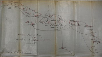
While acknowledging the Atlantic World as the broader geographical framework for the history of hurricanes as well as the longer historical trajectories of natural disaster and hurricane prediction that have shaped the Greater Caribbean, this article focuses more narrowly on the American occupation of Cuba at the turn of the twentieth century in order to analyze the creation and contestation of meteorological infrastructures on the ground.Footnote 18 This approach shifts the focus away from a macro-scale analysis of infrastructure and toward the micro- and meso-scales that are vital but sometimes obscured elements of what Paul Edwards has described as a “multiscalar analysis” of infrastructure.Footnote 19 This article's analysis of imperial meteorology from the bottom up and from the middle reveals that hurricane tracking and agricultural statistics were inextricably linked components of the U.S. Weather Bureau's meteorological infrastructure in the West Indies from its creation, which has not previously been acknowledged. This historical connection between weather and crop reporting reflects the interlocking imperatives of humanitarianism and capitalism that structured the American meteorological infrastructure in the West Indies. While sharing Warren's and Cushman's thematic focus on hurricane prediction in the context of imperial expansion, this article uses archival sources to offer a more fine-grained account of imperial meteorology in the West Indies that includes the voices of historical actors who debated the scientific, economic, and geopolitical stakes of hurricane forecasting. The archival record reveals how American imperial meteorology was met with not only resistance but also negotiation and cooperation on the part of elite Cuban scientists who sought to align themselves with the Weather Bureau as it established an official presence in the region.Footnote 20 The decentralized, local, and cooperative nature of weather reporting networks meant that the meteorological infrastructure of American empire would depend on hierarchies of imperial power and scientific authority as well as collaborative relationships with scientists, observers, and the press in the West Indies. (See Figure 1.)
This map drawn by U.S. Weather Bureau personnel in June 1900 depicts the information networks (lines indicate undersea cables linking the islands, and flags indicate stations where hurricane warnings were displayed) that were the most crucial component of American meteorological infrastructure in the West Indies during the U.S. occupation of Cuba. Reproduced from Weather Bureau Correspondence 1870–1912, box 1407, Records of the U.S. Weather Bureau, Record Group 27, National Archives, College Park, MD.

TRACKING HURRICANES BEFORE THE U.S.S. MAINE
Military conflict between the United States and Spain, which lasted from late April to mid-August of 1898, ended just as the worst of the hurricane season began. But Weather Bureau chief Willis L. Moore offered a moral explanation for the absence of storms during American naval operations: “Providence seemed to be on the side of those who fought against the oppressors of humanity … It seemed that nature was … letting the winds burst in one terrific hurricane after the American fleet had sailed north.”Footnote 21 Moore's connection between natural disasters and national security was a logical one in 1898, when American expansionism and the Weather Bureau's scientific aims converged, and fears of Spanish naval attacks and tropical hurricanes legitimated the extension of weather information networks into the West Indies. After the U.S.S. Maine explosion on February 15, 1898, Moore warned the president of the threats posed by the weather to seagoing vessels, and shortly thereafter, McKinley famously declared, “I am more afraid of the West Indian Hurricane than I am of the entire Spanish Navy.”Footnote 22
The U.S. Weather Bureau's extension into the West Indies took place in the context of turn-of-the-century expansionism, but both the United States and the Weather Bureau had sought an official presence in the region long before. The United States had made formal offers to purchase Cuba, under James Polk in 1848 and Franklin Pierce in 1854, and the Weather Bureau had long hoped that its information network would reach into the West Indies, as eminent meteorologist Cleveland Abbe noted in 1893:
The need of more reports from the West Indies, especially during the hurricane season, was very deeply felt in 1871, and the establishment of regular stations, manned by enlisted men of the Signal Service, was very exceedingly desirable; but this invasion of foreign countries, and especially the transmission of cipher dispatches presented many objections which could only be overcome by international courtesy.Footnote 23
This would-be “invasion” was more accurately a gradual expansion that yielded a meteorological infrastructure dependent on volunteer reports and hampered by financial constraints. Jamaican magistrate Maxwell Hall had tried unsuccessfully to establish a volunteer International West Indian Service, so the United States relied on hurricane and storm warnings from Havana's Belen College Observatory, and, in the late 1880s, on observations from U.S. consuls in the West Indies and Bermuda.Footnote 24 The weather information exchange between the United States and the West Indies was at times reciprocal. In 1889, the United States and the Spanish naval meteorological service worked on “the prospect of being able to exchange reports,” after which Spanish representatives of the Naval Observatory in Havana arranged to have U.S. consul observations telegraphed there, and by 1892, American and West Indian observers freely exchanged “special message[s]” of “unusual disturbances” during hurricane season.Footnote 25 However, the U.S. Weather Bureau's network in the early 1890s did not extend throughout the West Indies, and the dissemination of the information it did collect was limited. In 1892, the Bureau's Washington, D.C., office received information from paid observers in San Domingo, Kingston, St. Thomas, and Santiago de Cuba, as well as reports from Jesuit Benito Viñes in Havana and a voluntary observer in Bermuda. The Bureau also benefited from an agreement with the Bahamas that allowed free exchange of daily weather reports from Nassau to Jupiter, Florida.Footnote 26 Similar arrangements continued through 1895 and 1896, when the Bureau paid a few observers in Kingston, Santiago de Cuba, and St. Thomas, and received storm warnings from the Spanish Naval Meteorological Service and the Belen College Observatory.Footnote 27 Until 1898, the United States relied on this combination of existing telegraph networks, local weather observers, and voluntary international exchange of weather warnings.
Although unpredictable but inevitable hurricanes have been central to the history of the Caribbean—and appeared more numerous after the advent of improved data-gathering in the late eighteenth century—it was not until the late nineteenth century that new methods for hurricane forecasting emerged.Footnote 28 As Louis A. Pérez, Jr. notes, “The hurricane entered the cosmology of Cuba as a fact of life, a specter against which people were obliged in the ordinary course of events to mediate the possibility of potential catastrophe with the needs of daily life.”Footnote 29 The centuries-old epistemological tradition of ascribing hurricanes’ existence and force to divine Providence was augmented, beginning in the late seventeenth century, by conceptions of hurricanes as natural forces governed by natural laws.Footnote 30
The late nineteenth century marked the emergence of systematic empirical observation of storms combined with the use of telegraphy to track and predict what one writer called “the weather freaks of the West Indies.”Footnote 31 The presence of a hurricane was indicated by a slight rise and then a drop in barometric pressure; fluctuating humidity and dew points; observations of long, rolling swells at sea; visible changes in cloud formations and the sky at sunrise and sunset; and dramatic changes in wind and weather. Forecasters then used cloud movements to project storm tracks relative to these observations. As Francis Watts, government chemist and agricultural official for the Leeward Islands, explained at the turn of the twentieth century, “Much is heard about the prediction of hurricanes. It should be clearly understood what is meant by such an expression. The prediction of a hurricane weeks or months before its formation is clearly a thing impossible in the present state of our knowledge. All that can be done is to ascertain the existence and predict the probable course of a cyclone already existing.”Footnote 32 This method often worked quite well, as the Havana newspaper La Marina Cubana noted in a laudatory account: “formation, track and intensity [of hurricanes] can be determined, and forecast with nearly mathematical exactness—this the United States Weather Bureau does from the very valuable data which it has at its disposition.”Footnote 33
Cuban meteorological expertise became internationally renowned in the late nineteenth century through the work of Father Benito Viñes, a Spanish-born Jesuit who fled to France after the 1868 revolution and then came to Havana in 1870 to run the Belen College Observatory, where he built organizational and technoscientific infrastructures that transformed hurricane forecasting.Footnote 34 Jesuit observatories worldwide played a pivotal role in establishing educational institutions and meteorological reporting networks throughout the nineteenth century. Viñes fit into this history of what Gregory T. Cushman has characterized as “missionary science” as well as an established tradition of Jesuit scientific education in Havana at the Colegio de Belén, founded in 1854.Footnote 35 After publishing his first hurricane forecast in 1875, Viñes embarked on four “scientific inspection trip[s]” throughout Cuba, Santo Domingo, and Puerto Rico to systematically survey the destruction wrought by the hurricanes of 1876. He collected data on felled trees and floodwaters in addition to interviewing local residents and reading press accounts of the storms, noting that “[i]t is through the combination of all these methods that I was able to gather more or less complete data on the event,” which he published in his widely read 1877 Apuntes Relativos a los Huracanes de las Antillas en Septiembre y Octubre de 1875 y ’76 (Notes Concerning the Antilles Hurricanes of September and October of 1875 and 1876).Footnote 36 Following his individual observations of hurricane-ravaged landscapes, Viñes established the first weather reporting network in Cuba, a knowledge infrastructure that linked Belen College, Jesuit and lay observers, high-quality instruments, and the newspaper editors who published Viñes's hurricane warnings.Footnote 37 Viñes, seeking funding from the Spanish colonial government for such a network, which would finally be operational in 1887, emphasized the importance of a knowledge infrastructure to hurricane forecasting: “In the case of hurricanes, it is of utmost importance to acquire data in as many locations as possible … It is necessary for all to realize that without the availability of simultaneous observations made at different locations it is not possible to solve the problems that arise in each particular case.”Footnote 38 By the late 1880s, Viñes's publications and forecasting acumen had made him a leading figure in an internationalizing meteorological community, and his work was of particular interest to the United States, which exchanged observations and forecasts with him beginning in 1877.Footnote 39 Viñes's studies, which were excerpted and published in English, French, and German, were published in the United States starting in 1885 and frequently through the 1890s. The U.S. Weather Bureau chief endorsed one “as the most satisfactory statement of the laws and phenomena of these storms which has yet been made.”Footnote 40
Viñes's foundational principle of hurricane motion, what he called the “law of cyclonic currents at different altitudes,” emerged from his method of using daily cloud observations to track hurricanes. Viñes identified “cirro-stratus plumiformes,” which resembled “white and delicate feathers or like great and showy plumes crossing the firmament,” as unmistakable signs of an impending hurricane.Footnote 41 Once a storm had formed, Viñes used observations of clouds at different altitudes—from low clouds to a middle layer of alto-cumulus, cirro-stratus, and cirro-cumulus clouds to the highest light cirrus clouds—to calculate its probable direction based on the motion of air currents that tended to move low clouds perpendicularly to the storm center, while the uppermost cirrus clouds diverged from the storm center.Footnote 42 According to Viñes, cloud movement revealed the path of a storm “as if these clouds form an extension of the body of the hurricane itself,” and hurricanes followed predictable parabolic tracks westward through the West Indies before recurving—at different latitudes depending on the date—eastward into the Atlantic.Footnote 43
Viñes's projections of storm paths were generally reliable, as shown by favorable accounts of his forecasts in the Cuban press and the U.S. Weather Bureau's republication of his theories in their own bulletins, but not universally accepted.Footnote 44 In 1902, Weather Bureau official W. H. Alexander cited sailors’ demand for a “Storm Chart” showing typical paths of hurricanes, which he then produced using Viñes's correlations between the calendar and the latitude of recurving and included as part of his Weather Bureau bulletin entitled Hurricanes: Especially Those of Porto Rico and St. Kitts, published in 1902.Footnote 45 (See Figure 2.) Although Viñes's work appeared in multiple U.S. Weather Bureau bulletins, not all Bureau officials endorsed his laws of hurricane motion. As head forecaster E. B. Garriott wrote to Alexander, “There is no ‘usual or normal track of the West Indian hurricanes at the different periods of the hurricane season.’ … Neither have the most intense and destructive hurricanes followed the ‘normal paths,’ nor have they described a parabolic curve.” Garriott cited the historical charts of hurricanes the Weather Bureau had published in its 1900 bulletin on West Indian Hurricanes (see Figure 3), as evidence of twenty-three years’ worth of hurricanes that defied predictable parabolic storm tracks.Footnote 46 Viñes acknowledged that his projections of storm tracks were “approximate” and average but maintained that they also “offer[ed] in many cases great probabilities of truth,” forecasts that were clearly valued by his contemporaries, who considered him “among the foremost contributors to modern meteorology.”Footnote 47 Viñes died in 1893, two years before the final phase of the Cuban insurgency, but he had established a meteorological infrastructure in the West Indies that the United States would both rely on and appropriate during war with Spain and the subsequent American occupation.
Reprinted from William H. Alexander, Hurricanes: Especially Those of Porto Rico and St. Kitts (Washington, D.C.: Government Printing Office, 1902), 19–20.Weather Bureau official William H. Alexander, stationed at St. Kitts and Puerto Rico at the turn of the century, published a bulletin in 1902 in response to widespread demand among navigators for a chart of the typical paths of hurricanes and a set of guidelines for anticipating and navigating storms. This chart depicts Viñes's calculations of the “Law of the normal direction of the tracks at the different dates and altitudes,” which predicted a parabolic “recurve” at different latitudes and longitudes throughout the hurricane season. Track I indicates average storm tracks for June 1–10 and October 21–31; Track II, June 11–20 and October 11–20; Track III, June 21–30 and October 1–10; Track IV, July; Track V, August; Track VI, September.

Reprinted from E. B. Garriott, West Indian Hurricanes (Washington, D.C.: Weather Bureau, 1900), 75. E. B. Garriott, the head of the U.S. Weather Bureau's forecasting division, authored a bulletin that included historical charts, like this one for September from 1878 to 1900, mapping the tracks of West Indian hurricanes throughout the late nineteenth century, with the “mean track” indicated by a heavy black line.

MAKING “A SINGLE, COMPREHENSIVE SYSTEM”
Between the Spanish surrender at Santiago de Cuba on July 17, 1898, and the start of U.S. military occupation of Cuba on January 1, 1899, Weather Bureau personnel and Cuban meteorologists envisioned themselves as architects of a new meteorological infrastructure. Two prominent Cuban residents offered their expertise as the Bureau was beginning to establish its institutional presence: Jesuit Lorenzo Gangoiti, professor of meteorology and Viñes's successor at Belen College; and retired Spanish naval captain Luis Garcia y Carbonnell, director of the Spanish Naval Meteorological Service for the West Indies, who had previously worked in an informal capacity for the United States. While Gangoiti and Carbonnell were vying for recognition, the Weather Bureau was preparing to build an information network that would rely on local expertise but ultimately locate its authority in its Washington, D.C. office. The Weather Bureau's relationships with Gangoiti and Garcia y Carbonnell revealed the imperatives of a centralized bureaucratic order that privileged a distant rather than local authority, while at the same time complicating the framework of imperial power and local resistance, as Cuban elites sought to become part of a new American meteorological infrastructure.
Carbonnell had been making weather observations in Cuba since 1889, and by 1892 he was transmitting hurricane season reports from Santiago de Cuba and San Juan to the United States without charge.Footnote 48 Recognizing the opportunity for funding and prestige after the Spanish surrender, Carbonnell sought a formal role in the Weather Bureau as a mediator between the existing Spanish meteorological infrastructure and a new American one. Beyond recording and transmitting weather observations, Carbonnell offered to broker the purchase of instruments from Spain, hire a local forecaster, and help implement an experimental program involving the use of carrier pigeons to transmit weather data.Footnote 49 Initially, the Bureau was interested, and in September 1898 Moore asked Carbonnell to assess Spanish weather stations and instrumentation and send twice-daily observations from Havana to Key West in exchange for a new set of instruments, telegraphy costs, and “reasonable compensation.”Footnote 50 Carbonnell agreed but had greater ambitions, including plans to incorporate the morning and evening observations of well-regarded private forecaster Julio Jover y Anido; create a new station at Santiago de Cuba (which the Bureau already had established, unbeknownst to Carbonnell); and collect weekly or biweekly reports from Havana, Santa Clara, and Santiago de Cuba, “giving the maxima, minima and mean daily barometric pressure and humidity of the air, duration and force of the prevailing winds, kind and amount of clouds, with any other data that you may desire.” The enterprising Carbonnell also offered the pigeon house he had built in the Antilles Central Station observatory, his connections to pigeon breeder Dr. Chaquacedo, and his own breeding expertise, gleaned from “a good treatise of pigeon raising which [he had] studied.”Footnote 51 Moore, however, imagined a more limited role for Carbonnell, proposing to designate him an official Weather Bureau representative with the authority to conduct local administrative inquiries but declining to purchase Spanish instruments that weren't compatible with American instruments, employ Jover, or authorize anything beyond maintaining the continuity of daily observations.Footnote 52 Still, Carbonnell was seemingly on his way to, at the very least, a paid observer's position and official status within the Weather Bureau.
Carbonnell's major competition was Father Lorenzo Gangoiti of Havana's Belen College Observatory, who made two formal overtures in the winter of 1898, appealing first to fellow Jesuit J. G. Hagen of the Georgetown College Observatory, and then to Moore. For the political interim, Gangoiti proposed that Belen College be designated an official U.S. Weather Bureau station, citing its many advantages: its prominence in the network of Cuban observation stations, its ability to transmit at least one daily set of observations from Belen and other Cuban stations (and more frequent observations during hurricane season), and superior accuracy in measuring barometric pressure.Footnote 53
This competition between local experts posed a logistical and epistemological problem for the Weather Bureau. As head meteorologist Cleveland Abbe wrote to Moore,
there are in Havana three conflicting institutions and interests, all striving for recognition by you, namely: the Jesuit College; the remnants of the Spanish Marine and the remnants of the ‘Society of Planters’ with its meteorological library. The latter is a popular Cuban institution, but the two others … have not the popular support.Footnote 54
This existing meteorological infrastructure, which meant “at least three sets of differing observations, and … the respective observers … not working in entire harmony,” required, as head forecaster Garriott explained to Moore, an administrative consolidation in which meteorological work in Cuba would be overseen by one “who is thoroughly familiar with the methods and policy of this Bureau.”Footnote 55 Moore accordingly rejected Gangoiti's offer in December 1898, explaining that Carbonnell had an existing relationship with the U.S. Weather Bureau, his reports were “fairly accurate,” and “there [had] been no break in the continuity of his observations, which have always been satisfactory to us.”Footnote 56
Moore's dismissal of Gangoiti reflected the Bureau's imperative for standardization and centralized control of its weather network. Uncertain about the Weather Bureau's role in Cuba under U.S. occupation, Moore noted to a colleague, “If we establish a meteorological service of our own there it will undoubtedly be placed in supreme charge of some trained official sent from the United States, as we must have some one in charge of the work who is thoroughly acquainted with our methods, etc.”Footnote 57 Despite his efforts to secure instruments and office space and his tendency to submit copious amounts of data, Carbonnell received notification from Moore in January 1899 that his observations would no longer be necessary. The Weather Bureau's Kingston headquarters would be moving to Havana under the oversight of former Kingston forecast official H. H. C. Dunwoody and the daily management of Bureau official William B. Stockman. The Bureau had dismissed Gangoiti on the grounds that Carbonnell was more reliable, but then passed over Carbonnell in favor of Stockman, whom writer Erik Larson has deemed “a ponderous bureaucrat, given to writing immense reports about tiny things.”Footnote 58
The Weather Bureau encountered a range of obstacles—environmental, bureaucratic, and geopolitical—in building its West Indian meteorological infrastructure. An 1898 study of Cuba's climate noted that precipitation and temperature in the West Indies did not exhibit any kind of “tropical uniformity,” which underscored the need for a weather service to protect the two hundred vessels the United States had dispatched to Havana in the spring and early summer of 1898.Footnote 59 Congress approved the expansion of the West Indian weather service on July 7, 1898, only a week before hurricane season began, authorizing funding for new Weather Bureau stations at Kingston, Santiago de Cuba, Santo Domingo, St. Thomas, Barbados, Port of Spain, Curaçao, and Barranquilla, where hurricane warning signals were posted and observations were recorded twice daily and telegraphed to Kingston and Washington.Footnote 60 At a minimum, each station would be equipped with two anemometers (to measure wind velocity), an anemoscope (to register wind direction), two barometers, a set of thermometers, a rain gauge, and an instrument shelter.Footnote 61 However, the Bureau did not have enough instruments on hand for these stations and had to order them from vendors in Washington, D.C., and New York, and when the first Bureau officials arrived in Kingston on July 22, 1898, Stockman could not find any office space because Cuban refugees had taken shelter in any available structure. Stockman finally found an office outside of the city and set up headquarters there on August 7, 1898; and two days later, offices in Trinidad, Curaçao, Santo Domingo, and Santiago de Cuba were telegraphing weather reports twice daily to Kingston.Footnote 62 By 1901, the U.S. weather network spanned the West Indies, reaching from Port of Spain, Trinidad, to Havana, Cuba, with observations coming into Havana daily at 8 a.m. during hurricane season.Footnote 63 The Havana headquarters, which also received reports from various British weather stations as well as a few Mexican coastal stations, produced daily charts and compiled these observations for transmission to Washington, D.C.Footnote 64
The telegraphic cable linking West Indian weather reporting stations was itself a contested entity, given the political geography of the islands. At first the Weather Bureau encountered resistance from a few telegraph company managers who insisted upon prepayment for cables. Another problem involved coordinating the operating hours of West Indian cable offices, most of which closed before 6 p.m., with the Bureau's regular observation times. The Bureau shifted its evening observation one hour earlier but still could not convince the West India and Panama Telegraph Company to remain open later than 7:30 p.m. The Bureau appealed to the governor of Jamaica, who instructed the colonial secretary to confront the telegraph company directors with a warning “calling attention to the great detriment the early closing of the cable offices in the West Indies was to the efficient transmission of reports and warnings, particularly during seasons of unsettled conditions or the presence of storm conditions.”Footnote 65 The company agreed to change its policy for the next hurricane season by keeping its offices open until the Bureau's Kingston headquarters sent out a signal permitting them to close, thereby conforming the local communications network to the Weather Bureau's system for collecting and transmitting observations.Footnote 66
In March 1900, Secretary of Agriculture James Wilson explained to Secretary of War Elihu Root the Weather Bureau's plan to simplify and control the meteorological infrastructure in Cuba. He listed the various individuals and institutions that circulated weather reports and hurricane warnings, including sixteen reporting stations under Carbonnell's direction during Spanish rule, the Belen College Observatory, as well as private forecasters and other educational institutions. Wilson argued that only “a single, comprehensive system” of significant geographical scope should have the authority to make storm warnings, and his emphasis on infrastructural reach was echoed several months later by Moore, who commented on the “gigantic scale” of a West Indian weather reporting network and insisted that “no one can make forecasts for the West Indies without a comprehensive survey over a large area which must embrace all of our stations about the Caribbean Sea and the Gulf of Mexico and in the interest of commerce such forecasts should be made only by one institution.”Footnote 67 Their logic was driven by an economic imperative that Wilson made clear to Root: “There are many scientific men and many deserving institutions that are ambitious to issue weather warnings, but I am of the opinion that the welfare of the individual or the institutions should be subordinated to that of international commerce.”Footnote 68 Indeed, American officials emphasized the commercial benefits of a West Indian weather service from the very start, as the New York Times observed in July 1898: “The weather authorities explain that the service is aimed at the future great commerce expected to be built up there.”Footnote 69 And the long-term operation of a meteorological infrastructure in the West Indies would serve American interests above all, as Wilson noted: “I believe it will be imperative upon this Government, for all time to come, no matter who may be in charge of the local administration of Cuba, to insist on maintaining at least three meteorological observatories to form a part of the general West Indian service, which service is of more importance to the commerce of our Gulf and south Atlantic ports than it is to any of the islands of the West Indies.”Footnote 70
Creating a “single, comprehensive system” in the service of commerce required the construction of a singular scientific authority. U.S. Weather Bureau officials in the West Indies relied on reports of local observers to produce forecasts and storm warnings, but, just as they had done in the United States from the 1890s well into the twentieth century, attempted to suppress competition from private forecasters who challenged the Bureau's authority by policing their own infrastructure, the press, and the circulation of unofficial forecasts.Footnote 71 The Cuban press was the most visible site of contests over scientific authority, and Weather Bureau officials monitored press coverage accordingly, as they did in the United States. To take one example, in September 1899, two weeks after a hurricane left “[t]he desolation and ruin wrought by this monster in the West Indies … fresh in the minds of all,” a Bureau official wrote to the editor of Cuba's Diario de la Marina to protest the publication of Gangoiti's forecasts from the Belen College Observatory under the heading “El Tiempo” with the subheading “Departamento de Agricultura de los Estados Unidos—Weather Bureau” and to request that future reports “be so placed in your paper that there may be no doubt in the minds of your readers as to the source from which it emanates and that there may be no danger of confounding the official bulletins with those originating from a private source.”Footnote 72 Bureau officials also maintained tight control over access to their infrastructure for the same reason. In August 1900, Gangoiti requested current Weather Bureau data telegraphed from New Orleans but was told that “it would be manifestly unfair to the public and unjust to the Bureau to furnish individuals and institutions competing for public favor, with the data.”Footnote 73
Of course no weather service, however comprehensive or authoritative, can prevent storms, and when hurricanes did form, the Weather Bureau produced predictive storm warnings and retrospective calculations of damage sustained and avoided. Although the Bureau regularly published testimonials to the value of forecasts and storm warnings, hurricanes brought the greatest threat to human life and property and thus the most visible occasion for demonstrating, and sometimes debating, the efficacy of a government weather service. To take one example, the hurricane that swept from Puerto Rico to Florida between September 28 and October 2, 1898, was preceded by Weather Bureau advisory messages and storm signals from Key West to Norfolk, Virginia. The storm made landfall between Jacksonville and Savannah on October 2, causing widespread damage and loss of life, as crops, livestock, farmland, boats, railroad track, and telegraph lines were destroyed.Footnote 74 The Bureau's Florida section director A. J. Mitchell cited “incalculable damages” on the Georgia coast, but in most areas the damages were indeed calculated. Mitchell reported that “[a] conservative estimate of the damages in Florida may be placed at $500,000,” and estimated the probable cost of the hurricane absent Weather Bureau warnings as at least 10 ships (that heeded warnings and remained in port), with 56 crew members and $380,000 in cargo.Footnote 75 The value of hurricane warnings was also cited by those who did not receive them, including W. A. Bessey of Stewart, Florida, 20 miles north of Jupiter, who inquired on behalf of his neighbors why no warnings were issued in their area, observing that “[t]he severity of these storms and the terrible destruction … make it all most necessary that we know when they are approaching.”Footnote 76
Bessey's words would ring true again approximately two years later, when the deadliest hurricane in U.S. history devastated the booming port city of Galveston, Texas, on September 8, 1900. The Weather Bureau's Galveston forecast official, Isaac M. Cline, despaired that “the ruin which it wrought beggars description,” counting his wife among more than six thousand residents who drowned as floodwaters over ten feet high carried away bodies and debris, destroying 2,636 houses and causing an estimated $30 million in property damage.Footnote 77 Given the severity of the hurricane and the extensive loss of life and property, scholarly and popular accounts of hurricanes have ascribed to Galveston singular and unparalleled significance. However, in the context of meteorological infrastructures, Galveston was, in three important respects, not exceptional at all.Footnote 78
First, multiple and contradictory forecasts attempted to predict the hurricane's path and intensity, just as rainstorms and snowstorms in the United States were predicted by the U.S. Weather Bureau (and before it the U.S. Army Signal Service) along with myriad private short-term and long-range forecasters. There was no single Galveston forecast but rather multiple and changing forecasts produced by competing knowledge infrastructures, which Weather Bureau officials documented as a threat to Wilson's goal of a “single, comprehensive system.” A compilation of daily forecasts from August 30 to September 6, 1900, issued by the U.S. Weather Bureau, the Belen College Observatory headed by Lorenzo Gangoiti, and private forecasters Jover and Faquineto revealed a spectrum of risk ranging from the Weather Bureau's conservative description of a “disturbance” of “moderate energy” through September 4, to Jover's warning of a cyclone beginning on August 31. On September 4, Belen College noted that a “cyclonic disturbance” was atypically “preparing to recurve” toward the northeast, and the U.S. Weather Bureau maintained two days later that the storm center was continuing on a northeastward trajectory toward Florida; however, the hurricane had not recurved but rather had intensified and was headed northwest, straight for Galveston.Footnote 79
Second, although the Galveston hurricane made visible contestations over the relative accuracy of American and Cuban weather reports, controversy over forecasters’ authority and expertise in the aftermath of a storm was commonplace in the nineteenth century, as it has remained to the present day. Disputes over who had failed to correctly predict the intensity and track of the hurricane quickly emerged in American and Cuban newspapers. The Houston Post denounced “the failure of an adequate warning” from the congressionally funded Weather Bureau while praising the work of commercial long-range forecaster Rev. Irl Hicks, whose almanac had foretold—nearly a year earlier—“‘a decided storm period’” from September 6–11, 1900, and called particular attention to September 8 and 9 as days when “[i]t will be wise for dwellers on the south seas, islands and coasts to heed all signals of West India hurricanes at this time.” The editorial further suggested that a long-range forecaster like Hicks “take charge of the bureau and shake it up.”Footnote 80 Moore soon fired back in the pages of the Post, listing the warnings that his agency had provided by telegraph and signal flags before launching into the vigorous repudiation of long-range forecasting for which he became well known during his tenure as Weather Bureau head from 1895 to 1913.Footnote 81 This exchange between the head of the federal government's weather forecasting service and a newspaper editor over the value and legitimacy of short-term versus long-range forecasting was hardly unique to Galveston and occurred repeatedly in the aftermath of major storms, including the historic blizzard of 1888 and the Inauguration Day snowstorm in 1909.Footnote 82 Cuban newspapers also judged the Weather Bureau's tracking of the Galveston hurricane a failure. Havana's La Discusión faulted the Bureau for a “phenomenal error” in tracking and judging the severity of the Galveston hurricane, “which he [Moore] persisted in calling a little storm in all the advices [and predicted] was central in the north Atlantic when it was causing in Galveston the tremendous destruction that it did.”Footnote 83
Third, the Galveston hurricane revealed continuity rather than disjuncture in that it did not transform meteorological infrastructures or debates over forecasting in the region. Rather, Weather Bureau officials continued their existing efforts to achieve the ideal of a “single, comprehensive system” of weather forecasting in the Caribbean. In the summer of 1900, Bureau official H. H. C. Dunwoody had issued an order shutting down telegraphic transmission and publication of non-Weather Bureau forecasts—to the great objection of “cranks on the island,” he noted—but by mid-September Governor General Wood overturned Dunwoody's order.Footnote 84 Wood had, in the judgment of Bureau officials, yielded to pressure from private forecasters in Cuba and thereby “place[d] the Weather Bureau … on an equal footing with several little institutions, none of which is properly equipped to perform this important function for commerce.” Moore complained to the Secretary of Agriculture that “this Department cannot carry on an efficient Weather service and properly attend to the needs of commerce if the public prints of Cuba are to be filled with irresponsible forecasts from half a dozen sources, many of which forecasts are attributed by the public to the Weather Bureau.”Footnote 85 When Cuban meteorologists and editors sought to expand their own information networks, they continued to face resistance from Weather Bureau officials who, as Moore admitted, “feel like jealously guarding against the issuing of storm warnings by irresponsible persons or by those that have not sufficient data at their command.”Footnote 86 And editors of La Discusión alleged that Bureau official William Stockman had refused them weather data because the newspaper regularly featured forecasts by Gangoiti and Jover, a charge Stockman denied.Footnote 87
MAKING THE WEST INDIES LEGIBLE
In the mid to late 1890s, the U.S. Weather Bureau's meteorological infrastructure rendered the West Indies more legible by translating local weather observations into a systematized, centralized, and bureaucratized form of knowledge with economic value for American markets and investors. The West Indian weather service produced environmental and economic legibility through mapping, climatological data collection, and crop reporting—all forms of knowledge production that undergirded agricultural improvement, capitalism, and the civilizing mission of American science.Footnote 88
As the United States’ government weather service expanded and professionalized in the late nineteenth century, its research activities included mapping projects that aggregated data for use in long-range climatological studies and for inclusion on daily weather maps. In the mid-1870s, “hoping … to entirely surround the areas of high and low pressure that appear in our extreme northwestern border,” the U.S. Army Signal Service sought to extend its reach to the “distant territory” of Manitoba through the establishment of five regular observation stations in cooperation with the Hudson Bay Company. The Signal Service provided instruments for the prospective stations in 1874, but observations were never submitted, and in 1893, the government's leading meteorologist, Cleveland Abbe, lamented what was still a “blank upon the Daily Weather Map of North America.”Footnote 89 Regions south of the United States were also meteorologically illegible, Abbe noted:
To the south of the United States the meteorology of Mexico was almost a terra incognita; we knew something of its climatology, but the dynamic meteorology could not be understood without a daily representation of its conditions on the weather map. The United States series of stations stopped abruptly at the Mexican boundary … but although the extension of our isobars and isotherms over Mexican territory was desired … and even attempted … in 1882, from Brownsville southward to Panama and beyond, it is still unaccomplished; it is to be hoped that this important extension of the work of the Service may be carried out by the Weather Bureau under the Department of Agriculture. There is evidently still a great expansion to be desired in the immediate future of the Daily Weather Map.Footnote 90
Abbe's concerns about unmapped regions reflected the Weather Bureau's scientific aims as well as symbolic value of the daily weather map.Footnote 91 Collecting weather data beyond national boundaries would extend the physical reach of the Bureau's information network, but more points plotted on the daily map would also signify the nation's geopolitical reach and the professional legitimacy of a federal agency that had faced its share of public scrutiny.Footnote 92
Cuba in particular was environmentally illegible to the United States at the start of war with Spain. In May 1898, Weather Bureau officials confronted “scant” and “fragmentary meteorological data” and noted “very little precise and accurate information obtainable regarding the climate of Cuba.”Footnote 93 The rest of the West Indies was far more legible, with “a good deal of [precipitation and temperature] data” available for various proximate locations: “[t]o the north, Key West, Fla., and Nassau, Bahamas; to the east, Port au Prince, Haiti, San Juan, Puerto Rico, and St. Thomas; and to the south, Kingston and other stations in Jamaica.”Footnote 94
As Weather Bureau personnel noted their lack of climatological knowledge, American imperialists invoked a rhetoric of colonial improvement that linked the physical and moral transformation of the Cuban landscape from “‘hell … into a paradise,’” as Congressman Henry F. Gibson put it, justifying the Platt Amendment, which stipulated U.S. control over Cuban affairs beyond the end of occupation, to his House colleagues in 1901.Footnote 95 As Louis A. Pérez, Jr. has noted, popular accounts depicted a chaotic Cuba in need of modernizing infrastructure and celebrated the transformation of Havana through “‘an almost inconceivable amount of reconstruction, sanitation, reformation and improvement.’”Footnote 96 War had ravaged Cuba's agricultural landscape, eliminating 500,000 acres from overall production between 1895 and 1898; displacing farmers and laborers; destroying 903 out of 1,110 sugar mills; damaging warehouses, farm machinery, and machine shops; and weakening the transportation infrastructure of roads, bridges, and railroads.Footnote 97 Cubans condemned U.S. policy that left landowners with heavily mortgaged property and little hope of an influx of investment capital. In 1901, Secretary of Agriculture, Commerce and Industry Perfecto Lacosta lamented, “‘Up to the present time, nothing has been done toward the improvement of our agricultural situation.’”Footnote 98
Agricultural improvement was, however, an aim of the West Indian weather service, which was expanded to monitor agricultural production in Cuba and Puerto Rico through a climate and crop reporting network. As the New York Times announced, the Weather Bureau's Havana headquarters would afford unprecedented economic legibility: “our people will be fully informed as to the condition of everything meteorological and agricultural in the various portions of the island, and as to the progress of the rehabilitation of the industries which, during the recent war, were either suspended or completely annihilated.”Footnote 99 Contemporary observers judged climate and crop reports for American investors in West Indian sugar and tobacco production more valuable to the United States than the transmission of hurricane warnings for the safety of local inhabitants. In December 1898 the New York Tribune reported that climate and crop reports from Puerto Rico would “be published for the benefit of the people of the United States,” and a Weather Bureau official stationed in Havana commented in 1901 that “[w]hile the value of the service to the islands of the West Indies is great, it is all incidental, in a way, when we consider the benefits of this branch of the weather service to us at home.”Footnote 100 (See Figure 4.)
This representative photograph of a U.S. Weather Bureau station in the Philadelphia Bourse, c. 1900, indicates the prominence of predictive weather and climate data in the spaces of finance capitalism. Climate and crop reports from Cuba and Puerto Rico are posted to the right of the weather map, in the bottom row. Reproduced from Administrative and Fiscal Records, Records Relating to Opinions Concerning Emerson Hough's Article on the Weather Bureau, 1909, box 2, RG 27, NA-College Park, MD.

The Weather Bureau initiated its climate and crop reporting work in Puerto Rico in October 1898 and in Cuba in early 1899, providing thermometers, rain gauges, and standardized reporting forms for stations that were staffed by a group of “efficient observers,” including planters and other volunteers. By 1902, twenty-five observation stations and eighty-six crop correspondents comprised the climate and crop reporting network, and the Weekly Climate and Crop Bulletin was published in English and Spanish by January 1899 in Puerto Rico and May 1899 in Cuba. It included summary paragraphs describing rainfall and temperature and their effects on sugar cane, tobacco, corn, rice, and other crops, in addition to excerpts from observers’ remarks. Monthly summaries of meteorological data and observers’ comments, in both English and Spanish, came shortly thereafter.Footnote 101 Climatological charts included mean, highs, and lows for temperature, as well as total precipitation, precipitation highs, and the number of rainy days for each observation station. (See Figure 5.) Climate and crop reports were circulated by mail, newspaper, and telegraph, and the list of Cuban and American subscribers was lengthy.Footnote 102 Although the Bureau suggested that climate and crop reports would be instrumental in diversifying agriculture, the reports’ most important audience was potential investors in large-scale sugar cane and tobacco production since, as a Bureau official noted in 1901, “[n]aturally the first information sought by homeseekers or those contemplating the placing of capital in Cuba is about its climate.”Footnote 103 As U.S. military governor general John R. Brooke observed, the key to postwar economic development was to ensure that “‘capitalists [were] assured as to the future.’”Footnote 104
William B. Stockman, Report for September, 1899, Cuba Section of the Climate and Crop Service of the Weather Bureau (Havana, Cuba: Weather Bureau Office, 1899), 5.

The climatological data that assured capitalists of their future did not have the same predictive value for local agricultural producers, according to Weather Bureau officials who deemed climate and crop reports useless to Puerto Rican farmers on the grounds that they were not legitimate participants in modern markets, modern information networks, or modern agriculture. Bureau officials produced a technoscientific legibility by constructing rigid boundaries between what Bureau personnel perceived as their own modern scientific rationality and the irrational behavior of primitive island residents when it came to anticipating agricultural and meteorological futures. A Bureau representative in Puerto Rico noted that
The greater part of the masses … pay no attention whatever to the reports. They can't read. They perform all the labors incident to farming with a machete. They are not educated up to the fact that the reports are of value, and they will not be for some generations yet to come. We must consider that we in the United States raise crops in the most modern fashion possible, to the best interests of agriculture. But in Porto Rico methods are primitive; crops are put in and if they fail from lack of attention, such as being choked by weeds, or washed out by torrential rains from want of proper ditching, the planters shrug their shoulders and complain of fate. So we see how difficult it is to ascertain how much value the climate and crop service is to the large number of the islanders at least.Footnote 105
Similarly, hurricane warning signals announced not only an approaching storm but also American scientific and cultural superiority. In 1901, a Bureau official reported that skeptics in Puerto Rico were quickly converted into fervent believers in the authority of American meteorology:
When the hurricane signal was hoisted in the island the first and, thus far, the only time there was some scoffing by native “amateur meteorologists:” for, “How could Americans know anything about tropical hurricanes, having been here such a short time?” But the warning was so timely and the justification so absolute, that now almost any American red flag will have the effect of the bona fide hurricane signal. When the usual red flags are hoisted over the military rifle range for target practice the telephone rings, and terror-stricken inquires are made as to the (supposed) approaching cyclone.Footnote 106
Such panicked reactions were derided by Weather Bureau officials who did not intend their daily forecasts for circulation in the West Indies, according to the “rule [that] no public forecast is made unless disturbed or stormy conditions exist.”Footnote 107 The Bureau issued two types of public warnings for the West Indies: advisory messages and storm warning messages—the former intended to warn outgoing vessels of stormy conditions elsewhere, the latter to indicate a more serious and immediate local storm.Footnote 108 In urgent situations, the Bureau flew a storm warning flag, but, as an official acknowledged, “frequently the information is intended solely for the benefit of vessels ready to leave port and need not be communicated to the general public (as it might cause unnecessary alarm).”Footnote 109 When forecasts were more widely disseminated, Bureau officials blamed residents for failing to interpret them correctly, thereby causing “confusion and unnecessary alarm.”Footnote 110 Bureau personnel also denounced private forecasters’ “sensational and alarming reports” in favor of their own “conservative and reassuring” reports, justifying their tight control over local weather information and policy of “disseminat[ing] with discretion” by blaming a cultural “tendency on the part of the people to misunderstand them [storm warnings].”Footnote 111 Stockman, the Bureau official in charge of Havana headquarters, faulted Cubans for not acknowledging the value of U.S. government storm warnings: “At first it was difficult to interest the people in the warning service, since they are by nature very conservative and slow to adopt any change in their accustomed methods and mode of living. The issue of warnings of hurricanes was a most radical change, the inhabitants being accustomed to hear of these phenomena only upon their near approach.”Footnote 112 With this racialized logic of the capacity to comprehend knowledge of the future, Bureau officials legitimized their decision not to disseminate routine forecasts, thereby rendering Cuba less meteorologically legible to its own people.
After U.S. occupation of Cuba ended in 1902, its West Indian weather service continued in what Weather Bureau officials characterized as a mode of “mutually beneficial cooperation” in which the United States would allow Cuba access to its entire West Indian network in exchange for Cuban management of the four U.S. reporting stations in Cuba, located in Havana, Cienfuegos, Puerto Principe, and Santiago.Footnote 113 Bureau chief Moore noted in March 1902 that “[t]he proper protection of our own seaports on the Gulf and South Atlantic Coasts against the approach of West Indian hurricanes makes it necessary that we have a few observation stations under our control on the island of Cuba.”Footnote 114 Secretary of Agriculture Wilson offered to telegraph the Bureau's regular observations from its West Indian network and any additional U.S. stations the Cuban government desired, as long as Cuba's meteorological service restricted its own forecasts to the island. Further, the U.S. offered to notify Cuba of hurricane warnings for other islands in the West Indies and, in return, requested receipt of any hurricane warnings posted for Cuba. The United States was also granted permission to maintain its observation stations in Jamaica, Dominica, Barbados, and Santo Domingo in exchange for transmitting hurricane warnings to their governments and major shipping companies.Footnote 115 The end of American occupation, then, allowed the U.S. Weather Bureau to expand its reach and maintain its institutional presence throughout the West Indies.
But this is not to say that such an institutional presence faced no resistance. Moore observed in the aftermath of the Galveston hurricane that “people do not appreciate our service, that the only thing they want is to kick us and say good-bye.”Footnote 116 Moore's assessment was confirmed in July 1902, when private forecaster Julio Jover y Anido was asked by the editor of Diario de la Marina, the most widely read newspaper in Cuba, to comment on the U.S. Weather Bureau's official role in the new republic. Jover's response, subsequently published, conveyed a critique of imperial meteorology and recognition that an American observatory in Cuba would have “a great bearing with regard to our people, not only from a scientific point of view, but also from a politico-international one.” Jover resented the implication that Cuban meteorological traditions and the Belen College Observatory were in any way inadequate and professed, “I cannot understand how an official organization of such a nature was aimed at in a foreign country.” Jover went on to underscore the economic and political consequences of meteorological infrastructure, noting that “[t]he influence of a Central Observatory in a nation is of greater importance than it may appear at first sight. It has to deal with the calculations of the exact hour; it is in close relations with the Merchant and War Marine; it has a bearing on other geographical studies and many other questions of … international character. Can all this be entrusted to a foreign government? To grant Washington's demands would be in flat contradiction with the personality that Cuba actually enjoys.”Footnote 117 Jover's letter makes visible not only local resistance to scientific imperialism, but also how conflicts over meteorological infrastructure were embedded in a spatial politics of American empire.
The other part of the American meteorological infrastructure in the West Indies, the climate and crop reporting network, was officially transferred at the end of April 1902 from the U.S. Weather Bureau to the Cuban Department of Agriculture, where it was put under the leadership of Carbonnell, the former director of the Spanish naval weather service.Footnote 118 Although Bureau officials in Havana described the transition as formally “severing our connection” with local voluntary observers, the connection between American and Cuban meteorological infrastructures would endure.Footnote 119 By 1905, the Weather Bureau had scaled down its West Indian weather service, eliminating seven of fourteen stations and replacing Weather Bureau personnel with “non-commissioned employees,” namely operators at local telegraph companies, at the remaining stations.Footnote 120 Between 1906 and 1912, the Weather Bureau maintained between seven and nine such stations until expanding its reach between 1913 and 1918 to encompass the West Indies, the Caribbean Sea, and the Panama Canal Zone. In 1915 the Weather Bureau's annual report reiterated the connection between weather reporting, commerce, and military security that was the impetus for the creation of the West Indian weather service in 1898: “[t]he commercial as well as the naval and military interests of the country fully justify the improvement and extension of the work of the Bureau in the Panama Canal and the region of the Caribbean Sea.”Footnote 121
* * *
The history of the U.S. Weather Bureau's West Indian weather service is the history of a knowledge infrastructure that linked, in addition to weather observers and their instruments, the mutually reinforcing imperatives of imperial, scientific, and commercial expansion at the turn of the twentieth century. The meteorological infrastructure that produced hurricane warnings was a material and symbolic extension of American technoscientific power into the Caribbean, but the creation and operation of that infrastructure hinged on both cooperation with and control of forecasters and volunteer observers throughout the region. In constructing overlapping technical and professional networks that produced short-term hurricane warnings and climate and crop reports, the Weather Bureau relied on local knowledge and labor but then sought to control the circulation of its forecasts according to racial and scientific ideologies that cast residents of the West Indies as incapable of comprehending the work of American science.
As American policy makers anticipated the political future of U.S.-Cuba relations, short-term hurricane warnings and long-range economic calculations based on climate and crop reports constituted a form of environmental and economic foreknowledge that connected the United States to the West Indies. As Louis A. Pérez, Jr. has observed, “It became all but impossible for the Americans to contemplate their future-well-being without the presumption of possession of Cuba. … To have imagined the island as essential to the endurance of the nation … was to have implicated Cuba in the North American sense of future, which meant, too, that the future of Cuba was a matter over which the Americans laid claim as a function of their interests.”Footnote 122 The meteorological infrastructure that produced this knowledge about the future played a crucial role in the networks of scientific and commercial exchange linking the United States to the West Indies and beyond, thereby suggesting that historians might think productively about American empire in not only spatial but also temporal terms.
Just as narratives of interconnected American and Cuban futures circulated at the turn of the twentieth century, so too did narratives of the U.S. Weather Bureau's West Indian weather service. Government scientists published accounts of the new American meteorological infrastructure in which scientific collaboration and “international courtesy” achieved the humanitarian aims of a hurricane warning network.Footnote 123 In April 1899, the Monthly Weather Review celebrated the “international comity” of the West Indian weather service, noting that “[n]o act is allowed that could in any way be interpreted as an effort or willingness on our part to override local rights and the authority of the sometimes long-established local meteorological officials.” The article went on to declare, “It is disastrous to science whenever one man or institution overrides, absorbs, or destroys the honest work of his neighbors. ‘Cooperation and not monopoly,’ is the only principle that can lead to success in the study and practice of meteorology.”Footnote 124 Yet, as this article has revealed, principles of cooperation and monopoly were inextricable in the extension of an American meteorological infrastructure into the West Indies, and indeed U.S. officials relied on cooperation with Cuban scientists and observers precisely in order to create the “single, comprehensive system” envisioned by U.S. Secretary of Agriculture James Wilson that sought to suppress and control local scientific authorities. In this way the U.S. Weather Bureau's West Indian weather service depended on not only the construction of telegraph reporting networks but also the construction of narratives of technoscientific progress that at once legitimated and concealed the operation of a meteorological infrastructure in the service of American empire.