Introduction
Coastal zones are strongly impacted by the watersheds that feed them. Erosion from water flow, input of freshwater to the marine system and contaminants carried by the water affect physical, geochemical and biological processes in the nearshore. Catastrophic watershed events such as floods are well known to structure the topography. Antarctica is a desert and a frozen one at that, and large flood events impacting the coastal zone have not been observed. The Antarctic nearshore is generally characterized by a lack of watershed impacts and sedimentation. Here we present evidence of a large flood event that very much influenced the coastal zone at Salmon Bay in the south-western McMurdo Sound by depositing >50 cm of sediment on the benthic habitat. Furthermore, the flood appears to have influenced an ice-mediated sea floor uplift event in which artificial structures and considerable sediment were buoyed to the underside of the sea ice and ablated to the surface.
The McMurdo Dry Valleys are an extensively studied region in western McMurdo Sound, where the high land to the west restricts the continental ice sheet. When the ice sheet withdrew 10–15 million years ago it left the valleys with hanging glaciers, moraine deposits and lakes. However, the topography of the lower Dry Valleys reflects incursion of the Ross Ice Sheet from the Ross Sea during the Last Glacial Maximum, forming ice-dammed lakes and moraines (Hall & Denton Reference Hall and Denton2000, Hall et al. Reference Hall, Denton, Heath, Jackson and Koffman2015). In addition, summer floods occur in the Wright and Taylor valleys where glaciers empty into the lakes (Foreman et al. Reference Foreman, Wolf and Priscu2004, Doran et al. Reference Doran, McKay, Fountain, Nylen, McKnight, Jaros and Barrett2008, Chinn & Mason Reference Chinn and Mason2015). However, large flood events have not been previously observed to reach the coastal zone because of the buffering influence of the Dry Valley lakes as storage reservoirs. In the Salmon Bay region there is no lake, and flood events can move directly to the ocean with a large sediment load and with freshwater that freezes in the seawater that is almost 2°C below the freezing point of freshwater. We discuss the probable source of the event as well as the consequence of the flood of freshwater.
Methods
Study site
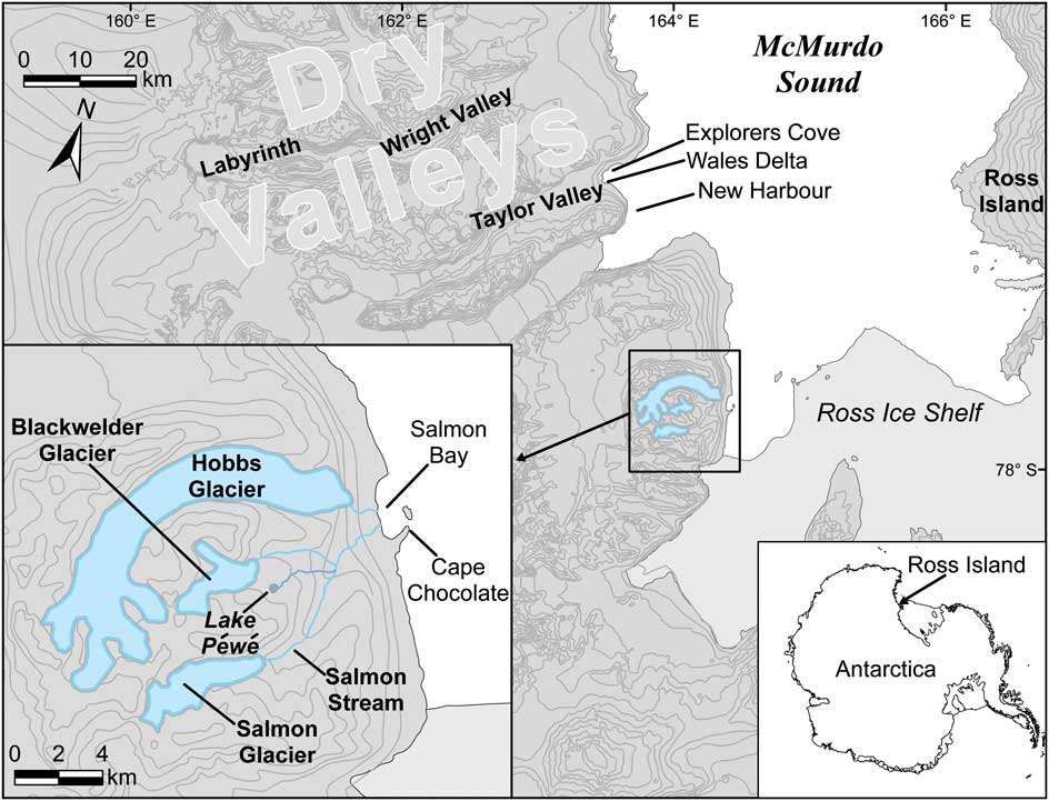
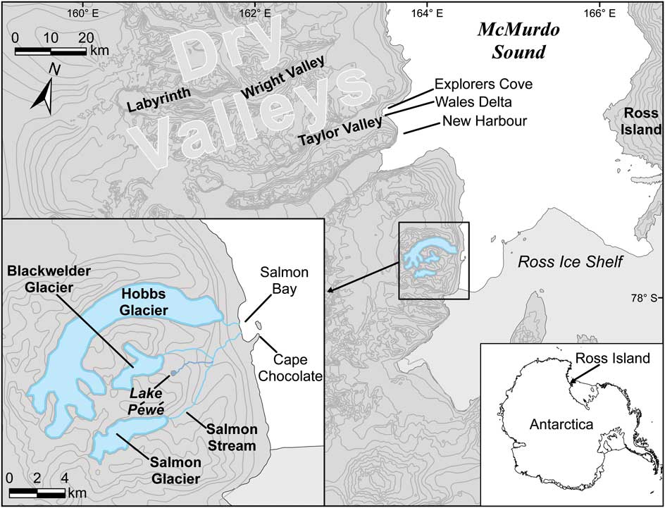
Salmon Bay is a large icebound bay protected from the offshore currents and ice by Cape Chocolate, a large terminal moraine from the Hobbs Glacier (Speden Reference Speden1960). A delta formed by the Hobbs and Salmon glacial streams dominates the east side of the bay and seasonal runoff from both streams flows into the bay. Hobbs Glacier is a little over 1 km and Salmon Glacier is c. 8 km from the bay. Blackwelder Glacier and Lake Péwé are on a plateau between Hobbs and Salmon glaciers and both drain into the Salmon Stream (Fig. 1). The sea ice in this area is usually 8 m thick.
Map of the Salmon Bay region showing the areas discussed in the text. The inset shows the location of the region on the Antarctic continent. The enlargement shows the Salmon Bay region relative to McMurdo Sound.
Historical and current observations and evidence
We established a marine ecology field station near the small stream from the Hobbs Glacier in the late 1980s to study nearshore benthic ecology. In 1988 we made two holes for scuba diving in the 8 m thick perennial sea ice c. 200 and 250 m from shore over water depths of 17 and 35 m. A characteristic of diving through old sea ice in this area is that the dive holes fill with freshwater that flows from very large pockets trapped in the ice (see also Gow et al. Reference Gow, Weeks, Hendrickson and Rowland1965) and by the end of the season there is a layer of freshwater that extends well below the bottom of the sea ice.
The 8 m thick and extremely rough sea ice indicated very infrequent ice breakout. We have worked in this area since the mid-1970s, and had not seen the ice break out through 2010. However, it did break out in February 2011 and again in February 2014. Patches of windblown gravel and large melt pockets characterized the old sea ice internally. Interestingly, the sea ice at Explorers Cove was also c. 8 m thick in 2010 (personal observation) and Murray et al. (Reference Murray, Miller and Bowser2013) report that the ice there had gone out in 1999. Therefore, the coastal sea ice in this area can grow to be some 8 m thick in 11 years. Salmon Bay ice was roughly the same thickness but much older (at least 35 years old), thus it appears the ablation and freezing at the bottom of the ice reach an equilibrium at a thickness c. 8 m.
We sampled the sea floor for invertebrates with small cores processed on shore. In 1989, we established ecological experiments including suspension feeding invertebrates suspended from floats as well as corrals of c. 25 m2 with three fences made of construction fence c. 1.2 m tall to exclude larger benthic predators. We returned in 2010 to survey the site using a small remotely operated underwater vehicle (ROV; Cazenave et al. Reference Cazenave, Zook, Carroll, Flagg and Kim2011) deployed through a Jiffy drill hole.
In both 1989 and 2010, we surveyed the watershed by foot to Hobbs Glacier and almost to Salmon Glacier. Satellite imagery of the area was provided by the Polar Geospatial Center, and the glaciers and shoreline were compared in ArcGIS. The resolution of available imagery varied; in 1986 and 1989 resolution was 30 m, from 2000–02 resolution was 15 m, and from 2009–11 the resolution was 0.5 m.
Results
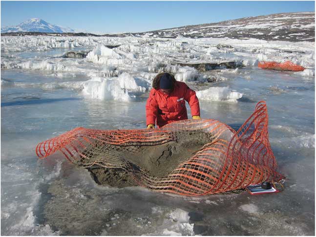
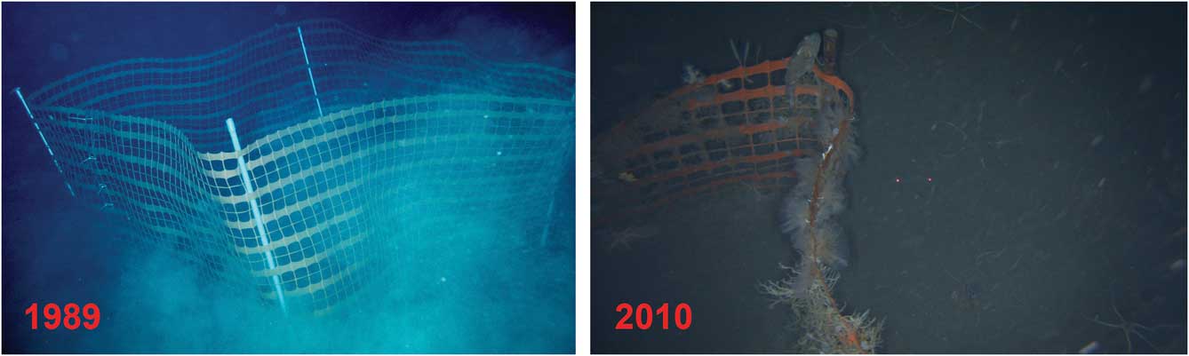
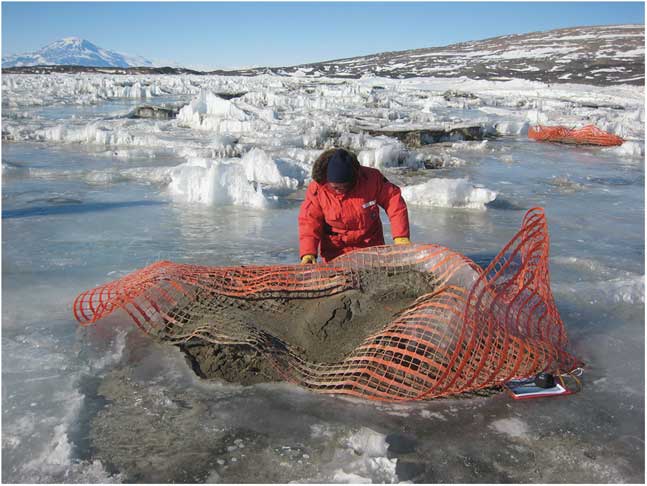
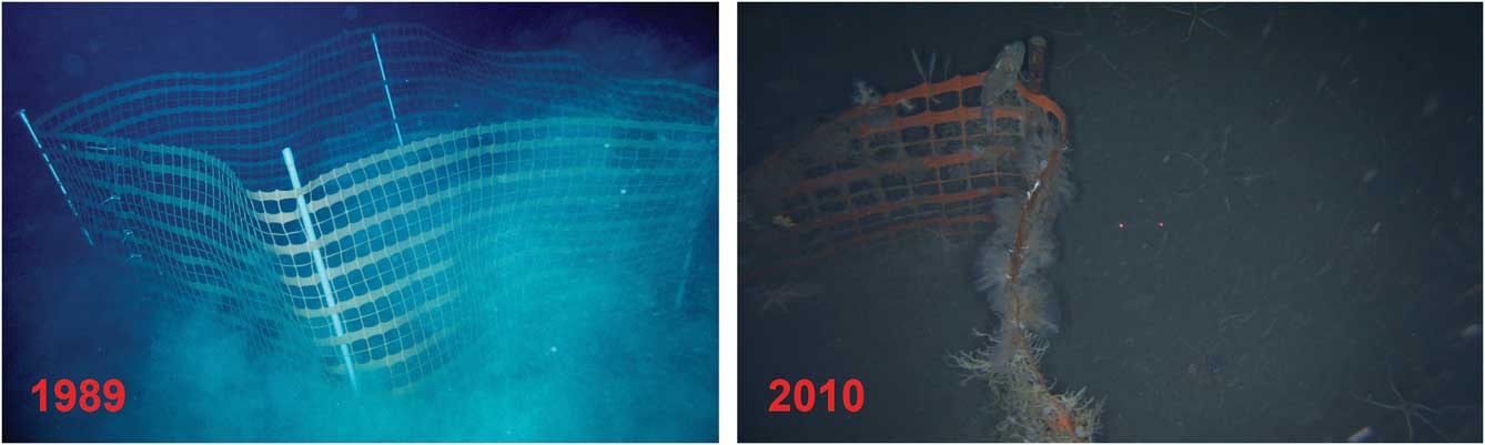
In November 2010, we found the hard blue ice that had refrozen from the freshwater in the holes left in 1989 was clearly visible suggesting that the ice had not gone out since the late 1980s, if not much earlier. Interestingly the ice was still c. 8 m thick, demonstrating that it has maintained about the same thickness over the preceding two decades. We also found that two of the three fences that were placed on the sea floor in 1989, at a depth of 17–20 m, had been uplifted, frozen into the sea ice and ablated through the ice where we found them on the surface with large loads of c. 2 m3 of sea floor sediment (Fig. 2). Analysis of the ROV video showed that more than half of one fence still on the sea floor was buried in sediment (Fig. 3).
Uplifted fence along with c. 2 m3 of sediment that came with it. The sediment extended >50 cm deep into the ice.
Before (left) and after (right) photos of the fence at 25 m depth that remained on the sea floor between 1989 and 2010.
Discussion
The occurrence of 50 cm of sediment washed into McMurdo Sound is a very unusual event considering that there is no record of enough runoff into the sea to move any measurable sediment at nearby, more intensively studied sites below Taylor Valley (Miller et al. Reference Miller, Fan and Bowser2015). It is especially unexpected at a site so far south, where melting is a rare event. In a very detailed study of sedimentation at Explorers Cove, Murray et al. (Reference Murray, Miller and Bowser2013) document very large amounts of windblown sediment on the sea ice, but that this sediment does not work its way to the bottom except when a tide crack releases it. The sea ice seems to reach an equilibrium between freezing at the bottom of the ice and ablation at the surface, and our observations suggest that sediment in old sea ice stays trapped in the ice as observed by Murray et al. (Reference Murray, Miller and Bowser2013), where the windblown sediments near the surface absorb sunlight and melt their way down into the ice, but rarely far enough to fall through. Our benthic study sites further north at Explorers Cove in New Harbor are several hundred meters offshore of the sites reported in Murray et al. (Reference Murray, Miller and Bowser2013), and our sites roughly share the same depositional environment as reported by Miller et al. (Reference Miller, Fan and Bowser2015). We note that the large Wales Delta in New Harbor (see Murray et al. Reference Murray, Miller and Bowser2013) has grown to >30 m wide between 1974 and 2010, yet the sedimentation there is barely enough to cover our thin nylon transect lines, with 2–6 mm of sedimentation at most after almost 40 years. This level of sedimentation is similar to the 0.02 cm yr-1 actually measured by Miller et al. (Reference Miller, Fan and Bowser2015) inshore of our sites. These estimates represent more typical coastal sedimentation rates on the West Sound (Murray et al. Reference Murray, Miller and Bowser2013, Miller et al. Reference Miller, Fan and Bowser2015). Clearly the 50 cm observed at Salmon Bay over 20 years is almost two orders of magnitude more than this rough average. This implies that this Salmon Bay event is extremely unusual over the last half century of research at McMurdo Sound.
The closest potential source of liquid water that might be sufficient to transport sediment into Salmon Bay is the Hobbs Glacier. Satellite images showed no detectable change in the Hobbs Glacier between 1989 (30 m resolution), 2000–02 (15 m resolution) and 2009–11 (0.5 m resolution). Our on-the-ground observations recorded c. 10–20 m retreat since 1989. However, our 1989 and 2010 photographs of the glacier indicated no signs of major water movement and the little outlet stream seems identical to what it was in 1989. Instead, the small retreat of the Hobbs Glacier looked to result from blocks of ice breaking off with subsequent melting. It is very unlikely that the Hobbs Glacier was the source of the 50 cm of sedimentation. Thus we believe that the large flood came down Salmon Creek between our visits.
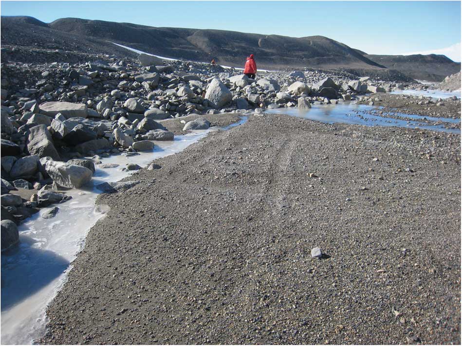
Neither watershed survey went all the way to Salmon Glacier itself nor was there an effort to survey the Blackwelder Glacier or Lake Péwé drainages, so we lack direct evidence of any changes in these glaciers. However, satellite imagery again indicated no changes in any of these areas. There were only a few photographs of the 1989 and 2010 reconnaissances up Salmon Creek, but in 1989 the valley was flat ‘pavement’ as described by Speden (Reference Speden1960). On the approach to Salmon Glacier there was a New Zealand survival hut. It was stocked but almost full of hoar frost and obviously had not been visited in many years. More interestingly, in 1989 there were several clear vehicle tracks along the creek bed from a vehicle that presumably had transported and stocked the hut. The brief 2010 survey was much more difficult because the streambed was full of large boulders, and in places was heavily eroded. We did not remember any such boulders before, and we did not find the hut. David Harrowfield (personal communication, 2015) informs us that the hut was placed in the area in the early days of geological research there. He reported that he believed it was transported there on a trailer pulled by a Ferguson tractor, and subsequently removed either by a helicopter or the trailer. He mentioned that another early research programme in the area had used the tractor and trailer, so one or another of these programmes was the source of the tracks and they would have been almost 30 years old in 1989 and almost 50 years old by 2010 as seen in Fig. 4. This implies little movement of sediments in or near the streambed over two to three decades prior to our 1989 visit, but substantive change in morphology between 1989 and 2010.
Old tyre tracks apparently cut off by debris flow, upper Salmon Valley, 2010. The white streak of snow in the background is the Blackwelder Glacier drainage, putting this photograph c. 1 km upstream from the confluence.
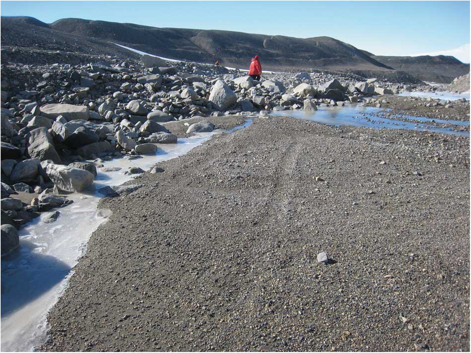
The fairly obvious tyre tracks we saw along the drainage in 1989 were mostly gone in 2010, and we only saw one 15 m stretch of eroded tyre tracks that obviously had been cut by a major flood (Fig. 4). The white strip of snow in the background of Fig. 4 is the drainage from the Blackwelder Glacier, well downstream of this photo. This implies that much of the water came from the Salmon Glacier, although both glaciers may have contributed to the flood. We propose that the flood may have coincided with the 2001–02 warm year, when the Dry Valleys lakes experienced flooding (Doran et al. Reference Doran, McKay, Fountain, Nylen, McKnight, Jaros and Barrett2008).
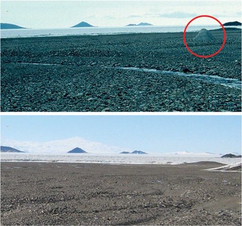
While Fig. 4 and the marine sedimentation are the best evidence of a major flood, we also have a pair of pictures (Fig. 5) from the Salmon Creek delta that show a large rock in 1989 that is apparently missing in 2010 and we speculate that it may have been buried by the debris flow. The two photographs were not taken from the same spot because the 2010 photo was farther up the delta. But notice the typical desert-varnish covered pavement in 1989 was replaced with a very mixed material in 2010. It is obvious that a great deal of sediment had been transported over the delta sometime between when the photos were taken as the pavement from 1989 is totally replaced by flood debris. It is hard to imagine that the large boulder was moved all the way to the bay or that it was covered with that much sediment, but we have not been able to find it in enlargements of the 2010 photo, even though we are able to align images against geographical features to ensure we are looking at the same sections of stream bed. We were also unable to locate the boulder in the 0.5 m resolution satellite imagery from 2009–11.
Upper Salmon Creek delta in 1989 (top) and 2010 (bottom). The large boulder visible in 1989 is expanded from a zoomed image (cobbles are the only scale) but could not be found in a similar photo from 2010. The photos were not from the same spot, but they are similar in perspective as can be seen by lining up the offshore Cape Chocolate ‘islands’.

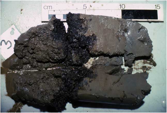
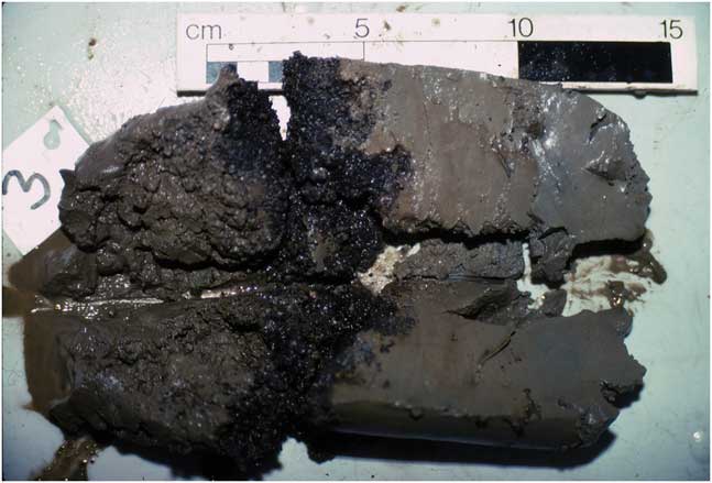
In addition to the event we describe here, there is evidence in the sea floor sediment of an earlier event. Our benthic ecology work involved taking cores in from the study site. The cores that we collected in the late 1980s offer evidence of an earlier event as they all had a layer of gravel a bit more than 5 cm below the surface (Fig. 6). At the time we considered that the uniform nature of the layer and the uniform composition of the small gravel in the layer might have been from a general aeolian deposit when the ice was thin enough so that the black material uniformly melted through the ice. The gravel is relatively well sorted as predicted by Miller et al. (Reference Miller, Fan and Bowser2015) for windblown sediment working its way through the ice. We did not see it in cores outside of Salmon Bay. The clay above the gravel seems much finer than the Explorers Cove sediment (personal observation, Miller et al. Reference Miller, Fan and Bowser2015), so it may represent much slower rates of sedimentation than seen at Explorers Cove. If the Miller et al. (Reference Miller, Fan and Bowser2015) estimate of sedimentation calculated from Explorers Cove is roughly correct, this event would have been between some 220–500 years ago, or perhaps it even reflects a strong wind driven event during the Antarctic version of the medieval warming at 1000–1200 yr bp (Wilson Reference Wilson1964, Lyons et al. Reference Lyons, Tyler, Wharton, McKnight and Vaughn1998, Doran et al. Reference Doran, McKay, Fountain, Nylen, McKnight, Jaros and Barrett2008).
A sediment core taken from 27 m at Salmon Bay in December 1989 showing a thick layer of small gravel below 5–6 cm of fine sediment. This layer of gravel was uniformly found in all of the cores in the study site.
The observation of the uplifted fences and large amounts of sediment may contribute incrementally to the Swithinbank (Reference Swithinbank1970) and Gow et al. (Reference Gow, Weeks, Hendrickson and Rowland1965) excellent reviews of the mechanisms of uplift in which they consider anchor ice as reviewed by Dayton et al. (Reference Dayton, Robilliard and DeVries1969), and basal freezing as carefully discussed in many papers by Debenham (cf 1965). Anchor ice is formed by frazil ice attaching to the bottom, and it can grow to the point that it floats sea floor material up to be incorporated into the sea ice, where overlying ice can ablate away until the material reaches the surface. The formation of frazil or anchor ice depends on super-cooled water and is pressure dependent. As Swithinbank (Reference Swithinbank1970) discusses, it is a common but coastal phenomenon because the ice formation is pressure restricted in deeper waters. From our previous observations, it can lift a few tens of kilograms but not hundreds of kilograms. We have never seen frazil or anchor ice deeper than a few meters at New Harbor or Salmon Bay, and the amount of sediment uplifted by the fences seems far heavier than anchor ice could lift. Debenham (Reference Debenham1965) posited deeper basal freezing processes that also seem to lift heavier material.
We hypothesize that a large pool of freshwater from the flood was injected under the sea ice, and it may have come in contact with the fences at a depth of 17–20 m. In this case freshwater exposed to the much colder seawater would have resulted in basal freezing as suggested by Gow et al. (Reference Gow, Weeks, Hendrickson and Rowland1965), Debenham (Reference Debenham1965) and Swithinbank (Reference Swithinbank1970). Thus we interpret our observations to support a blend of the Debenham (Reference Debenham1965) and Gow et al. (Reference Gow, Weeks, Hendrickson and Rowland1965) hypotheses of basal freezing and ablation moving the material to the surface as observed here, rather than anchor ice uplift. We have observed our own lost floats and dive lights to come through to the ice surface in less than 10 years, suggesting that in these windy coastal areas ablation is faster than the 0.5 m yr-1 estimated by Swithinbank (Reference Swithinbank1970) and others.
Clearly the upper Dry Valleys were influenced by flood events during geological time, especially the Miocene (Smith Reference Smith1965, Lewis et al. Reference Lewis, Marchant, Kowalewski, Baldwin and Webb2006). More recently, the topography of the lower valleys was created during the Last Glacial Maximum by the advance and retreat of the Ross Ice Sheet that left the moraines and lakes (Denton & Marchant Reference Denton and Marchant2000, Hall & Denton Reference Hall and Denton2000). While summer melting results in runoff into the lakes (Chinn & Mason Reference Chinn and Mason2015), there has been no evidence of flooding until the dramatic ‘flood year’ of 2001–02 (Doran et al. Reference Doran, McKay, Fountain, Nylen, McKnight, Jaros and Barrett2008) that included melting from glaciers in Taylor Valley with a significant rise in the lake levels. But the runoff went into the lakes rather than creating a massive flood to the sea. Assuming the Salmon Bay event also occurred in the warm year, it shows the importance of lakes and the moraine dams of the other valleys in protecting the coastal marine habitat from the sedimentation of such flood events. Brenda Hall (personal communication, 2015) also reported signs of flooding in the Marshall Valley, south of Salmon Valley. Thus the flooding may have been a general event in the Royal Society Range. In any case, sedimentation in Antarctic coastal areas is rare although it has been reported at Potter Bay on the Antarctic Peninsula where it had important effects on the benthic biota (Mercuri et al. Reference Mercuri, Tatian, Momo, Fuentes and Sahade2008, Torre et al. Reference Torre, Servetto, Eory, Momo, Tatian, Abele and Sahade2012). At Salmon Bay, the biota was absolutely buried, and by 2010 only a few species of bryozoan and echinoderms had recovered.
We offer no specific mechanistic hypothesis, but warming at global scales has resulted in dramatic changes in the Greenland ice sheet including an increase in the amount of surface meltwater and an increase in iceberg calving rates (Tsai & Rice Reference Tsai and Rice2010). Understanding the physical processes by which meltwater affects glacier dynamics is important for predicting the effects of warming trends in Antarctica as well as Greenland. One process in particular that deserves attention is the drainage of surface meltwater lakes to the base of the ice sheet, thereby potentially lubricating the bed. In Greenland this drainage may be rapid, implying turbulent flow of water as we observed here.
Conclusions
The purpose of this brief note is to alert others that some large event happened between 1989 and 2010 upstream of Salmon Bay in Salmon Creek, probably involving the relatively small Salmon and Blackwelder glaciers. The sedimentation dimly seen in the underwater photos of the fence, and the amount of material brought to the surface offer hard evidence of a single big event. The fact that the tyre tracks seem to have been buried by large boulders, the rugged heavily eroded nature of the streambed and the apparent burial of the large rock in the delta certainly suggest a large flooding event. Our recognition of the event was serendipitous, and we were not able to study the obvious massive impacts on the benthic ecosystem. However, it is clear that with future warming these flood events will become much more common, and there is an urgent need to study this site and also to establish some form of regular monitoring for inevitable future sedimentation events around the Antarctic coastal zone.
Acknowledgements
We thank Vonda Cummings, David Harrowfield, Molly Miller, Brenda Hall and George Denton for helpful comments. We are grateful to Brad Herried, PGC, for providing satellite imagery. This material is based upon work supported by the National Science Foundation under grants PLR-1355533 and ANT-0842064. Any opinions, findings and conclusions or recommendations expressed in this publication are those of the authors and do not necessarily reflect the views of the National Science Foundation.
Author contributions
Conceived and designed the study: PKD, SK, SCJ. Executed and interpreted findings: PKD, KH, SCJ, SK, WN, DJO, SFT. Contributed photographs and observations: PKD, DJO, KH, SFT. Wrote the paper: PKD, SK, SCJ.