

Introduction
It is common wisdom in Turkish historiography and public opinion to maintain that since the Kasr-ı Şirin or Qasr-e Shirin / Zohab Treaty of 1639, Iran and Turkey have not had any border-related problems. This is because the borders that were settled by the Treaty have been respected and remained unchanged.Footnote 1 While this school claims that Turkish–Iranian relations have been stable since 1639, a cursory look at these relations makes it crystal clear that stability in those relations was conjectural and not the norm. Whenever the parties had their hands free from the other fronts, they did not hesitate to attack each other. Notwithstanding the rocky nature of relations between the Ottomans and various dynasties that ruled Iran, the 1639 Treaty has been hailed as a foundational document. It could even be considered a myth in the historiography of Ottoman–Iranian relations. This article argues that the Treaty of Zohab (also Zuhab and Zehav) is only a step in the evolution of a boundary that took almost 400 years to reach maturity. No doubt the 1639 treaty was a significant step in what could be defined as the transformation of a hudud into a sınor/sınır or borderland into a boundary, but it did not define the Ottoman and Iranian frontier as we know it. It is a considerable stride in the long process that Charles S. Maier defined as the territorialization of space and sovereignty, which in the example of Ottomans and Iranians reached its climax only in 1913–14.Footnote 2 This becomes clearer when one looks at Ottoman–Iranian relations from the borderland rather than from the center.
A cursory look at Ottoman–Iranian wars, the negotiations that followed, and the treaties they concluded over the centuries reveals that frontiers and related issues were at the heart of their entangled histories. Neglect of this fact is due, in part, to the abovementioned tradition in Middle Eastern historiography, inspired by nationalist chronologies, which proposes that the Iranian–Ottoman boundary—at present shared by Iran, Turkey, and Iraq—is one of the oldest in the world, already established in 1639 and surviving to the present.Footnote 3 Yet this frontier, which first began to take shape in the early sixteenth century, was not a formal border. As was the case with most pre-modern borderlands, there was no exact line of demarcation, and the entire region was characterized by multiple social, linguistic, and political identities. Even in the nineteenth century, it resembled many things, but a pacified and settled borderland it was not. Indeed, until the mid-nineteenth century, the territorial limits of both the Ottoman Empire and Iran were to a large extent defined by the pledged allegiance of local groups; and since the primary loyalty of these groups was to their own territories, such allegiances shifted as the incessant struggle for hegemony continued. The limits of the respective states relied on the local actors’ recognition of a particular suzerainty, and not a clearly defined territorial sovereignty. This does not mean that there were no borders. In most cases the jealously guarded domains of local aristocracy defined the limits of Iran and the Ottoman Empire. For example, the boundaries of the Kurdish Baban dynasty of present-day Iraqi Kurdistan and the Ardalan dynasty of Iranian Kurdistan were effectively the Ottoman and Iranian boundaries in Kurdistan.Footnote 4 Or in the Shatt al-Arab region, which later became highly contested due to the rising importance of river navigation and related projects in the nineteenth and oil in the twentieth century, it was the allegiance and identity of local tribes that defined the limits of respective states. The Arab Kaʾb tribal confederation’s religious affiliation, Shia, secured Iran the left bank of the river, which was the most contested piece of land along the whole frontier.Footnote 5
The making of the actual boundary as we know it today, or its delimitation, demarcation, and cartographic production, was a process that started in 1842 and ended early in the First World War. Stretching over a period of seventy years, the Russian, British, Iranian and Ottoman diplomatic and technical teams intermittently came together and, following intense negotiations, carried out surveys to transform this borderland into a boundary. In that sense the evolution of the Ottoman–Iranian boundary is quite typical and the 1639 Treaty, for example, could be compared to the 1659 Treaty of Pyrenees which completed the “historical creation of the Pyrenean frontier” between France and Spain. Similar to the Ottoman–Iranian frontier, here too “the boundary line, as permanent expression of territorial sovereignty, only made its appearance in the nineteenth century.”Footnote 6 To better explicate the evolutionary formation of the Ottoman–Iranian boundary, the first half of the article, which is mostly based on the Ottoman sources, will provide a very short history of the Ottoman–Iranian treaties from 1555 to 1914. The second half of the article will go over various versions of the 1639 treaty and show how its consideration as a foundational frontier document emerged as an idea during the negotiations between boundary commissioners of the mid-nineteenth century (1843–47).Footnote 7
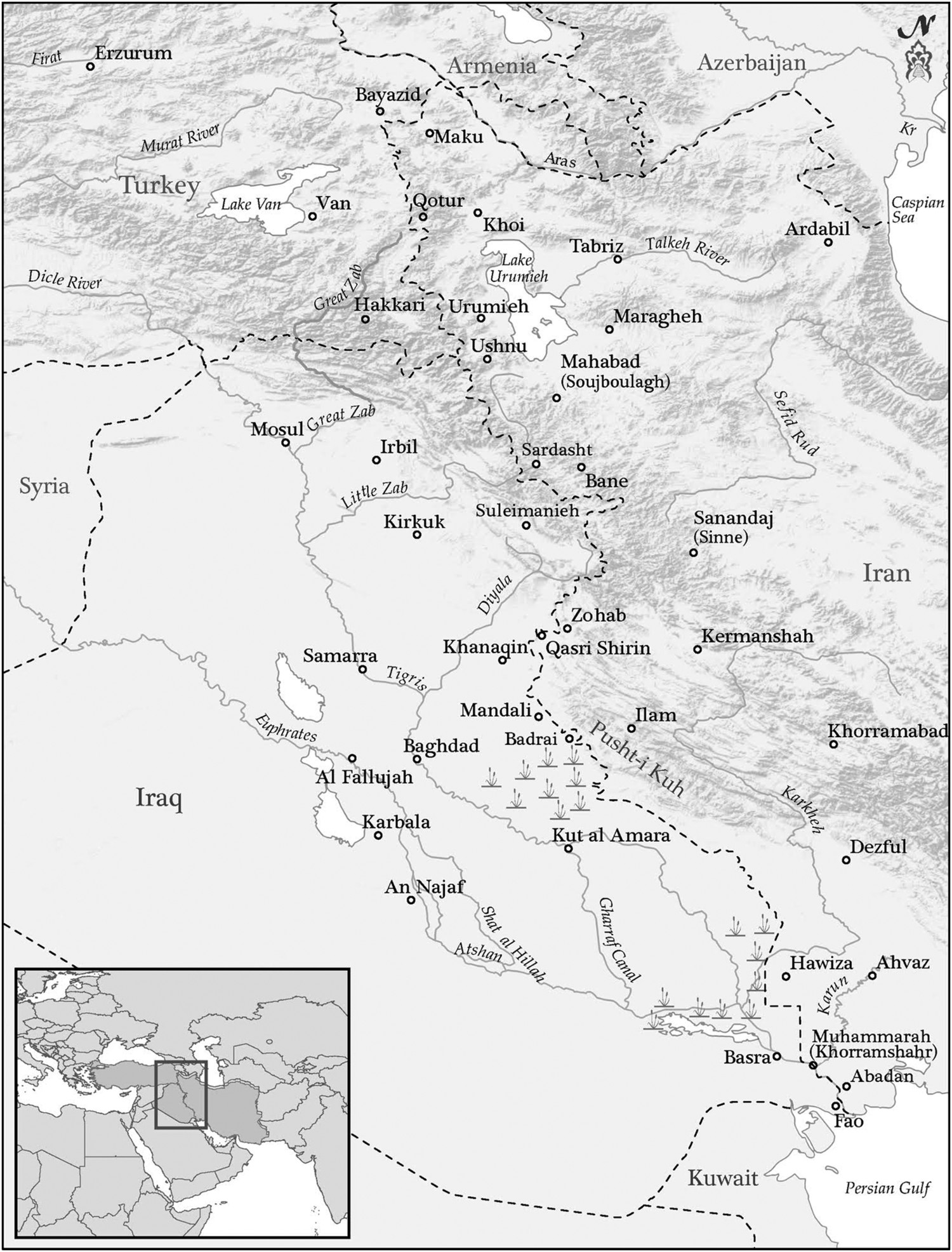
Map 1. Ottoman-Iranian Borderland.
Source: Map reproduced with permission from Ottoman-Iranian Borderlands.
Seen through the lens of boundary-making, the 1639 treaty was not a rupture in time and space. The making of the boundary was a process that took centuries to reach maturity. As Benedict Anderson has noted in another context, “Triangulation by triangulation, war by war, treaty by treaty, the alignment of map and power proceeded.”Footnote 8 The demarcating of the boundary was also facilitated by shifting ideas of territorial sovereignty, “which gradually heightened the importance of the boundaries of kingdoms at the expense of other divisions; local, pacific boundaries eventually merged with militarized state frontier defenses into a single concept of sovereign divisions between states.”Footnote 9 Charles Maier has described such shifts as the “transformation of territoriality,” in which a bounded territory and the control of populations within it increasingly became “the premise of state sovereignty.”Footnote 10 In the Ottoman–Iranian borderland, as in Europe, this “evolving premise of social organization,” with foundations gradually laid out in previous centuries, emerged around the mid-seventeenth century (with the 1639 Treaty of Zohab and Westphalian Settlements of 1648), experienced decisive modifications in the eighteenth century (1747 Treaty of Kurdan), and culminated in the nineteenth century (starting with the First Erzurum Treaty of 1823, and continuing with the Second Erzurum Treaty of 1847), when states successfully intensified efforts to territorialize, integrate, and reclaim space with the help of new technologies. The resulting contest between states for control over a finite space and its inhabitants is the process of “transformation of borderlands into boundaries.”Footnote 11
The Ottoman–Iranian Treaties and the Question of Frontiers
After years of military and ideological confrontations between 1512 and 1554, the Ottomans and Safavids signed the first “treaty” describing their mutual frontiers in the town of Amasya on 21 May 1555. This treaty came about as a result of Sultan Suleiman’s (r. 1520–66) eastern campaigns between 1533 and 1555. Despite containing the Safavid expansion through “the creation of governorates general in Erzurum, Van, Baghdad and eventually Basra,” and its alliance with the Kurdish aristocracy,Footnote 12 the campaigns showed that checkmating the shah would be difficult, if not impossible; a different strategy was necessary.Footnote 13 Consequently, the Treaty of Amasya was signed. This marked the first time the Ottomans recognized Safavid Iran as a legitimate entity.Footnote 14 Notwithstanding its vagueness on the frontier, referred to as hudud or serhadd throughout, the letters exchanged allowed each party to acknowledge the other’s respective domains and sectarian affiliations that would come to evolve as the defining markers of their identities. Notably, this was also the year that the Peace of Augsburg officially established the legal basis for the existence of Protestant and Catholic sovereigns in the Holy Roman Empire. Despite their various differences, it could be argued that those two developments are interrelated and these processes were part of an intercontinental phenomenon that encompassed early modern Eurasia.Footnote 15 With this treaty, similar to the Catholics and Lutherans, the Shiʾi Safavids and Sunni Ottomans started to negotiate terms of an uneasy coexistence, while initiating a period of the territorialization of sovereignty that would take a long period of time to finalize. As Kaya Şahin has noted, similar to Augsburg, Amasya followed a period of intense propaganda and warfare between the Ottomans and Safavids. The signing of the treaty signifies the defeat of earlier Ottoman claims of universal sovereignty and religious and spiritual leadership under a single ruler, Sultan Suleiman. By this treaty the parties offered reluctant but formal recognition of the other side’s creed as both a legitimate religious discourse and a political identity.
Neither the treaty of Amasya nor that of Augsburg, however, put an end to the religio-political confrontations they sought to ameliorate. Dividing Georgia between them,Footnote 16 the negotiations granted the Ottomans Iraq, most of Kurdistan, and western Armenia, while Iran kept parts of Kurdistan, Azerbaijan, Yerevan, and Nakhchevan. At the time it was signed, Erzurum, Diyarbekr, Zulkadriyye, Baghdad, and Shahrizur were also securely in Ottoman hands, with the local Kurdish principalities in Erzurum, Van, and Shahrizur provinces serving as a buffer between the Iran and the Ottomans, and preventing Safavid expansion into Anatolia, where the masses were more sympathetic to the Safavids. While the negotiations left certain regions in Ottoman hands and others in Safavid hands, the limits of sovereignty were not clearly delimited. Studying a group of manuscripts collectively known as Histories of the House of Osman (Tevārih-i Āli Osman), created by Maṭrāḳçı Naṣuh between the 1530s and the mid-1550s, K. E. Ebel has shown that, at this time, frontier cities were used to mark the limits of the Ottoman Empire, because “the administration of the frontier revolved around the local roads and towns that provided crossing points for travelers.” Frontier crossing in an ambiguous transitional zone, that is, was not accomplished by stepping over an invisible line but rather by arriving at the first town on the “other side.”Footnote 17 Since the frontiers of the states were fluid and ever shifting, the limits of the state in Maṭrāḳçı’s works were visualized through a “constellation of points”—that is, cities and towns—rather than by unbroken lines.Footnote 18
Dividing territories and marking frontiers were not the only preoccupations of the treaty, whose terms regarding the religious-political nature of the conflict are also significant. The sultan, at the request of Shah Tahmasp (r. 1524–76) promised protection of and free access for Iranian pilgrims traveling to the holy Shia shrines (ʿatabāt-i ʿāliyāt or meşahid-i muqaddese) and safe transit to the hajj in Hejaz, and emphasized that these places were open to all Muslims (umum muslimin). By including Safavid adherents within the community of Muslims, this last clause points to a conceptual turn in Ottoman–Safavid relations. This was a clear break with the Ottoman practice of the previous decades. Hitherto, the Ottoman establishment located the qezelbash in three overlapping categories of mürtedd (apostates), rāfizi/rafidhi (rejectors), and mülḥid (deviators or heretics). Making war on such “lapsed or heretical” Muslims required a fetvā, or edict of excommunication, which famous sheikh al-Islams like Kemālpaşazāde (d. 1533), and Ebuʾs-suʿud (c. 1490–1574) and their successors willingly provided. Because the sultan promised to protect the honor (namus) of the prophet’s companions, the shah, in turn, pledged to cease abusing Sunni Islam by curbing irreverent and offensive language when referring to the first three caliphs of Islam, the prophet’s wife Aisha, and the Sunni faith in general, and putting a stop to public cursing ceremonies (tabarraʿ).Footnote 19 Ottoman requests for the cessation of this practice, and its continuation in the face of such requests, as well as Iranian requests for the cessation of the mistreatment of Iranian pilgrims, did not end with Amasya and remained as a sine qua non of the Ottoman–Iranian treaties from 1555 to 1823.
While the negotiations of Amasya dealt with the most pronounced sectarian issues and the parties acknowledged the status quo, as Kaya Şahin notes, unlike the treaty of Augsburg, the Treaty of Amasya did not deal with the issue of the religious affiliation of the subjects vs. the ruler, nor was the treaty the outcome of negotiations in a Diet.Footnote 20 Amasya did not deal with the religious affiliation of the Shia subjects of the sultan or the Sunni subjects of the shah. The treaty was codified after the Iranian envoy Kamal al-Din Farrukhzada, who was received with all due respect and pomp, visited Suleiman’s camp at Amasya. Negotiations between the Iranian envoy and the Ottoman dignitaries were followed by a series of letters exchanged between the shah and the sultan. The Amasya Treaty, therefore, in essence is an exchange of letters that have been reproduced in Ottoman accounts like Feridun Bey’s Münşeʾāt-i Feridun or Celāl-zāde Mustafa Çelebi’s Tabakātüʾl-Memālik.Footnote 21
The peace engendered by the 1555 treaty lasted about two decades, and thus could be seen as what General Ferdinand Foch said of the Versailles Treaty: “This is not peace, it is an armistice for twenty years.”Footnote 22 Indeed, due to a variety of reasons, the discussion of which is beyond the bounds of this article, soon afterward the parties were at war and the Treaty of Amasya was no more. A twelve-year-long period (1578–90) of extremely brutal warfare and unimaginable destruction on the Caucasian frontiers followed.Footnote 23 By 1584, after Osman Pasha’s victory at the Battle of Torches (Meşale) at Shirvan, “the Ottomans had largely stabilized their hold over Daghestan, Shirvan, and Georgia and had made important preparations for an all-out attack on Azerbaijan by occupying Erevan and the mountainous parts of Kurdistan.”Footnote 24 The destruction of Tabriz and its people followed, and the devastated city remained in Ottoman hands from 1585 to 1603.Footnote 25 In the meantime, the Safavids suffered similar destruction on their eastern frontiers. Herat, Sarakhs, and Mashad fell to the Uzbeks in 1589 and, for a time, it appeared that sectarian wars would tear Iran apart. At this moment, however, the seventeen-year-old Shah Abbas (r. 1588–1629) arrived on the scene.Footnote 26 At the same time that Ottoman concerns regarding Habsburg pressure were intensifying and thus making them amenable to peace, uprisings inside Iran and Uzbek pressure in Khorasan left the young and pragmatic Shah Abbas with few options. Thus, a large Iranian delegation arrived in Istanbul on 24 January 1590 to sign the Treaty of Istanbul.
When they began to negotiate, in his letter to the shah Sultan Murad III (r. 1574–95) made it clear that the purpose of this treaty was to define the frontiers by establishing the hudud and sınur based on the Amasya Treaty, also known as Sultan Suleiman’s sınur, adding that the essence of the agreement was the cessation of anti-Sunni practices.Footnote 27 In his letters to Shah Abbas the sultan requested that plenipotentiaries (vekil) from both sides work with local elders to delimit the boundaries of Hemin, Darna, and Dartang (sanjaks in the Zohab region), again according to Suleiman’s sınur, that is the Treaty of Amasya.Footnote 28
It is noteworthy that this was the first Ottoman–Iranian treaty to establish that plenipotentiaries (tarafların vekilleri) and knowledgeable elders of local communities would be appointed to delimit and demarcate their mutual frontiers and boundaries. Indeed in 1591, after consulting with local elders, the plenipotentiaries demarcated the boundaries of Azerbaijan, placing boundary marks at key locations and agreeing that the Aras and Kür Rivers would act as the boundary of Shirvan, Revan (Yerevan), and Ganja.Footnote 29 Where it was more difficult to demarcate the boundary, mountain peaks were accepted as frontiers and, in accordance with the treaty, some settlements close to the boundary were demolished. Additionally, they agreed that at the serhadd of Baghdad-Shahrizur, the districts of Kelhuristan, Harunabad, Pelengan, Mihriban, Meragha, and Sinne (if the latter’s hakim submitted to Istanbul) would be left to the Ottomans. The most vexing issue of the 1590 negotiations was the castle of Nihavand, deep in Iran near Hamadan, which was under Ottoman control.Footnote 30 Here it was finally agreed that parts of Azerbaijan, including Tabriz, Ganja, Qarabagh, Shirvan, Revan, Georgia, Nihavand, parts of Luristan (whose wālī had taken refuge on the Ottoman side), Baghdad, Shahrizur, and their dependencies would remain in Ottoman hands, and that kat‘ı hudud or frontier delimitation officials would be appointed for the delimitation of this portion of the frontier.
Although humbling in some respects, the treaty established a security that allowed the young shah to consolidate his rule. Iran asked Istanbul for the return of Nihavand Castle as well as for help against the Uzbeks, but Istanbul refused both requests.Footnote 31 Soon, however, the tables were turned. The long and devastating Jalali uprisings at the turn of the century, facilitated by the Ottoman–Austrian wars and the weak rule of Murad III and Mehmed III (r. 1595–1603), which was followed by the ascension of Ahmed I in 1603 (r.1603–17), provided Isfahan with a golden opportunity. As the uprisings engulfed Anatolia and Baghdad, Shah Abbas took the initiative. Freed from the suffocating pressure of the Uzbek Shibani dynasty since 1598, he recaptured most of Khorasan before moving to overturn the terms of the Istanbul Treaty. By 1604, he had razed Nihavand Castle, and regained control of Tabriz, Revan, and Nakhchivan—that is, most of the lands the Ottomans had retained with the Treaty of Istanbul.
Still, it was only after several more years of sporadic clashes and further destruction of the frontier regions that, in 1611, the two parties began discussing terms of peace and the delimitation and demarcation of the frontiers (kat‘ı sınır and ta‘yin-i suğūr). By now in possession of Azerbaijan, Georgia, and Shirvan, Shah Abbas asked that boundaries be drawn according to the Amasya Treaty, while the Ottomans requested the return of Sunni-inhabited lands, which meant significant chunks of western Iran.Footnote 32 The war officially ended with what Ottoman sources call the Nasuh Pasha, or Istanbul Treaty of 1612.
As a clear indication of the importance of the sectarian divide between the parties, the final text (ahidnāme) sent by Sultan Ahmed to Shah Abbas was penned by the Ottoman sheikh al-Islam. The Ottomans required the cessation of anti-Sunni practices while promising free access for Iranian pilgrims to Mecca. Referring to Suleiman’s hudud as the basis of negotiations, this treaty required the delimitation of the frontiers (katʿı ḥudūd) and the prevention of interference (menʾi sudūd) in internal affairs. Istanbul authorized the muhāfız of Baghdad and the beylerbeg of Van to appoint a plenipotentiary. Shah Abbas likewise authorized the hākim of Revan to demarcate the frontiers in accordance with the 1555 Treaty. In 1614, the appointees drafted a sınırnāme, or frontier document, but disagreed on the ownership of Akhiska, then in Ottoman hands. In this document, Istanbul requested: (1) the acceptance of the hududs of Sultan Suleiman; (2) the cessation of anti-Sunni practices; (3) the cessation of the subjection of Sunnis to cursing and permission to leave Iran for those desiring to do so; (4) non-intervention in the affairs of provinces under Ottoman control; (5) Iranian pilgrims’ procession through Aleppo and Damascus rather than Basra (where Ottoman control was negligible); (6) the recognition of Ottoman suzerainty over Shamkhal and other rulers of Daghestan; (7) cooperation against the Russians in the planned campaign; and (8) non-interference in Shahrizur, that is present-day northern Iraq.Footnote 33
Due to disagreements over the question of ownership of Akhiska, soon thereafter the parties prepared for yet another confrontation; but following the unsuccessful Ottoman siege of Revan in 1616, and a devastating Ottoman loss at Serav (Serab) the Ottoman commanders appealed for peace. The Treaty of Serav, signed on 26 September 1618, reiterated many clauses of the previous treaty regarding frontiers and sectarian conflicts.Footnote 34 The only difference was that the Iranians agreed to leave the castles of Kars and Ahıska to the Ottomans and the tribute Iran was supposed to send to Istanbul was reduced from 200 to 100 bales of silk.Footnote 35
As if to underscore the transitory effect of this and the preceding treaties, in 1623 Shah Abbas I, yet again, in complete disregard of the recognized frontier, took advantage of upheaval in the sultans’ court, a revolt in Erzurum, and disturbances in Baghdad to occupy Baghdad and its surrounding Shi’i sacred geography. Ottoman efforts to take Bagdad back in 1625–26 and 1629–30 were unsuccessful. It was only after Shah Abbas’ death and Sam Mirza’s ascension as Shah Safi (r. 1629–42) that the Ottomans retook the initiative under the strong leadership of a matured Murad IV (r. 1623–40) and recaptured Baghdad in early 1639. The Ottoman conquest of Baghdad came at the tail end of years of confrontation that devastated the borderland region and the life of its peoples once more. Informed by geopolitical and sectarian rivalries, these utterly destructive wars, “which began in 1514 and lasted intermittently until 1639 should be regarded as one of the principal causes of the decline of the Ottoman Empire,” the eminent Ottoman historian Halil Inalcık added.Footnote 36 No doubt, the same wars and others that engulfed the borderland in the following centuries left long-term negative effects on the borderland and its myriad communities. Cycles of destruction that the Ottoman and Safavid armies wrought on the borderland left a permanently underdeveloped and sparsely populated region, as long-term accumulation of resources became nearly impossible. Similarly, the socio-political organization and even architectural landscape of the borderland still carries the scars of these wars and the concluding treaties that required the destruction of almost all castles and forts, consequently depriving the region of its historical legacy and memory.
When his forces completely destroyed the Iranian forces, and the city of Baghdad was emptied of its Shiʾi population, Sultan Murad left Kara Mustafa Pasha, the veziriazam, in Baghdad for negotiations and returned to Istanbul on 14 January 1639. Following negotiations, the parties signed what has been variously referred to as the Sultan Murad–Shah Ṣafī; Qaṣr-e Šīrīn/Kasr-ı Şirin; Zohāb/Zehav/Zuhab Treaty—which was signed at Zohab near Qasr-i Shirin on 14 Muharram 1049/17 May 1639 and, following the shah’s approval, ratified by Murad IV in January 1640.Footnote 37
Like its predecessors, the 1639 agreement did not lay down a precise line but rather designated entire regions lying between the two states as “frontier.” Still, as will be extensively discussed below, it did define parts of the frontier less ambiguously than earlier treaties by making reference to mutually recognizable landmarks (including military installations) and inhabitants.Footnote 38 As such it was a significant step in the process of territorialization of sovereignty. Almost all versions of the treaty that we have make it clear that the parties agreed on non-intervention in each other’s internal affairs, respect for the agreed-upon borders, as well as the free movement of merchants across the borders. Uncertainties concerning the movements and allegiances of nomadic tribes, reluctance on the part of the negotiators to be too precise in the hope that the future might offer opportunities for expansion, and lack of the required technology of mapping might have contributed to the lack of precise lines as well. Nonetheless, as the late Stanford Shaw has argued, the 1639 treaty was honored in the following years, “but less out of genuine friendship rather than as a consequence of internal weakness, preoccupation with the reform, and foreign aggression.”Footnote 39 Small skirmishes and inadvertent cross-border confrontations continued to occur, but peace between the two states prevailed. Indeed, this treaty helped usher in the longest period of stability in Ottoman–Iranian relations, eighty years without major confrontations. This gave the Ottomans a freer hand in defending their crumbling western frontiers. One could speculate that if the Safavid “menace” had continued in the east, the Ottoman collapse on the western frontiers could have been even earlier.
The Post-1639 Treaties
The long period of peace it ushered in, therefore, makes the Treaty of Zohab a landmark in the history of Ottoman–Iranian relations. The treaty effectively stayed in effect until the end of the Safavid state in 1722. Yet, as has always been the case, the shifting situation on the western frontiers of the Ottoman Empire influenced its dynamics with Iran. After what one scholar has called the formal closure of its frontier in Europe at the turn of the eighteenth century, the eastern frontiers yet again emerged as a zone of expansion.Footnote 40 This coincided with the substantial weakening of the Safavids, triggered also by Shiʿi–Sunni tensions in Iran’s various frontier regions. The Afghan occupation of Iranian lands up to Isfahan, and the Russian occupation of Baku in 1723, provided the Ottomans with an opportunity to redress the land loss they suffered on their western frontier during the period that began with the unsuccessful 1683 siege of Vienna and ended with the treaty of Passarowitz in 1718. The spoils of Safavid disintegration were appetizing. By May 1722, orders had already gone to the governors of the eastern provinces “to mass their forces and move into Iranian territory without delay.”Footnote 41
The Safavid disintegration, as Ariel Salzman has argued, overturned the West Asian order suddenly and radically.Footnote 42 When the last Safavid shah asked for Ottoman help against the Afghan occupiers, Istanbul asked for the return of all the provinces it had previously claimed. Suddenly the frontiers established by the 1639 Treaty or “Suleiman’s sınur” were no more, and the Ottomans, just like the Iranians had previously, saw no harm in stabbing their Muslim neighbors in the back. The Russian occupation of the silk-producing Caspian provinces of Daghestan and Shirvan (1722), made Istanbul uneasy and triggered its occupation of western Iran.
When the Ottoman divan, or council of ministers, met to discuss the situation in Iran, true to the Ottoman tradition, and in contradistinction to the spirit of previous treaties, it argued that, according to many books of Islamic jurisprudence (fiqh), the Shiʿis (Rafidhi taifesi) were considered apostates (mürted) and infidels (kafir), and therefore fighting them was tantamount to fighting polytheists. Additionally, the council argued in favor of declaring war against Iran in order to free cities inhabited by Sunni Muslims, and so secure peace and tranquility on the eastern frontier.Footnote 43 After this meeting, Ahmed III (r. 1703–30), taking a page from a well-rehearsed repertoire, sent a ferman to the commanders of imperial and local troops preparing to march on Iran. The sultan reminded them that the highly regarded books of the ulama, including Bezzazîye, Tatar-hāniyye, Hulāsa-i fetāvā, Şerhi’l-hidaye, and Fetāvā-yü’z-zahriyye, declared the lands of Iran to be dār al-harb and issued fatwas that declared the duty to kill men (rical) of revafız-ı kızılbaş who refused to become Muslims and to destroy and subjugate their communities. He ordered the ghazis to faithfully wage ghaza and jihad on the enemies of the religion (düşmen-i din).Footnote 44 In another ferman, in which he urged his armies to recover certain districts that had historically belonged to the Ottomans, the sultan spoke of the protection of the “ḥudud and thughūr” of the exalted state against the apostates, which is superior to jihad against the infidels.Footnote 45
Armed with such fatwas, the Ottomans did not hesitate to occupy western Iran. In places like Tabriz and Maragha, the Shiʿi communities resisted Ottoman Sunni domination, and “suffered major physical damage in addition to a large exodus of their residents” to the countryside.Footnote 46 Notwithstanding such resistance, the Ottomans acted as if the 1639 Treaty had never existed. However, in a relatively short time the Iranians, thanks to the leadership of Tahmasp Quli Khan, later Nadir Shah, were able to overcome the tremors of the Safavid disintegration. As a result, the frontier areas kept changing hands during the rise and fall of Nadir Shah. In 1733 Sultan Mahmud I (r. 1730–54) refused a provisional peace that Tahmasp Quli Khan had signed with the governor of Baghdad, which had called for a return to the terms of the 1639 Treaty, with guaranteed borders, an exchange of prisoners, and protection for Iranian hajj pilgrims.Footnote 47 Conflicts continued to erupt intermittently in the borderlands until towards the end of 1745. In September of 1746, at the village of Kurdan near Tehran, Nadir Shah met an Ottoman envoy and signed a treaty “that ostensibly recognized their common ‘Turkman’ origins and the conversion of Iran to Sunnism but was in essence a restatement of 1639 treaty of Zohab. It restored the borders of that time and guaranteed the good treatment of Iranians making pilgrimage to the Shiʿi shrine cities of Iraq.”Footnote 48 While Nadir Shah’s efforts to have a larger theological debate and have Ja’fari Shi‘ism accepted as a Fifth Madhab failed to yield any meaningful results, the treaty reiterated the promise that the Iranians would put an end to the ritual cursing of the first three caliphs. As Iranians had been continuously complaining about the mistreatment of Shia pilgrims traveling to ʿatabāt-i ʿāliyāt and hajj in Mecca, the treaty also acknowledged Iranians’ right to continue engaging in distinctly Shiʿi practices.Footnote 49 As Ernest Tucker argues:
The 1746 Kurdan treaty formally defined a new basis for relations between Iran and the Ottomans. It set aside the theological justifications that the Ottomans had long retained for declaring war on Iran as necessary, as well as envisioning the creation of an Ottoman–Iranian relationship sanctioned by Islamic principles that were respected by both sides. Despite Nadir’s assassination a few months after the accord was signed, it remained the basis of future relations, even during the chaos that arose in Iran during the last few months of Nadir’s reign and continued after his death.Footnote 50
Istanbul sent Kesriyeli Ahmet Pasha with gifts to seal the new pact, but he was too late. Nadir, the most successful of Iran’s post-Shah Abbas rulers prior to the 1796 establishment of the Qajars, had been assassinated by his own troops. Nevertheless, the Treaty of Kurdan created a new modus vivendi, which, despite continuing instability in Iran, lasted until the end of the reign of Sultan Mustafa III (r. 1757–74). But the time of Sultan Abdulhamid I (r. 1774–89) and the final years of Karim Khan Zand (r. 1750–79) witnessed the emergence of new and serious complications that would burst into the open with the Ottoman–Iranian war of 1821–22. This war paved the way for the final delimitation and demarcation of the Ottoman–Iranian frontier that would start in 1847 and end in 1914.
Very much as the Ottomans kept doing, when opportunity arose, Karim Khan did not hesitate to exert his authority over Shahrizur, carry out attacks into Anatolia and Baghdad, and occupy Basra while ravaging many other Ottoman interior settlements. Most importantly, two of his actions would be definitive for the future of the frontier and the long frontier negotiations. By exerting some sort of authority over the Sunni Kurdish Baban dynasty of Suleimanieh, Kirkuk, and environs he provided Iran with a claim over the affairs of what today could be considered Iraqi Kurdistan. When later the final frontier negotiations unfolded, the Iranian frontier commissioners continuously raised the issue of Iranian rights to the province of Suleimanieh, even if mostly for bargaining purposes. More importantly, Karim Khan’s snatching Zohab from the Abdullah Pasha of Kurdish Bajalan tribe created one of the longest running disagreements during the later boundary delimitation and demarcation process.
At the end of the eighteenth century, as the Qajars established hegemony over most formerly Safavid-controlled lands and attempted to solidify their hold over the surrounding areas, a new era of Ottoman–Iranian antagonism began, in which the hitherto ill-defined, porous borderland emerged as the most contentious matter. In 1821–22 two ambitious and rival Qajar princes, the governor of Azerbaijan Abbas Mirza and his brother Muhammad Ali Mirza Dawlatshah, the governor of Kermanshah, tried to expand the Iranian frontiers at the expense of the Ottomans in Kurdistan. Even though these efforts were cut short due to the emergence of cholera and Dawlatshah’s sudden death, the Iranians were able to solidify their control of some disputed districts like Zohab and the Qasr-i Shirin area. Following negotiations between the Ottoman Rauf Pasha and the Iranian envoy Mirza Mohammad ʿAli Ashtiyani, on 28 July 1823 the first Treaty of Erzurum was signed.Footnote 51 With its preamble emphasizing Islamic brotherhood, it was worded as if it were a renewal of previous treaties and existing hudud. The terms it employed to describe geographical boundaries and other issues relied heavily on language used in the 1746 Treaty of Kurdan, and not the 1639 Treaty. True to the increasing importance of territoriality and control of populations, the treaty also demonstrated a novel concern with the movements of tribes across frontiers, and pilgrims from Iran to the holy cities in Iraq and Arabia, which, due to their continuous mistreatment in Ottoman lands, had always topped the list of the Iranian demands at the negotiation table.Footnote 52
Like its predecessor treaties, the 1823 Treaty only brought temporary relief to the borderland and its peoples. Tension due to problems caused by an undefined frontier kept arising between Istanbul and Tehran. When they were getting ready for yet another confrontation in the early 1840s, Russia and Britain intervened and brought the process of the territorialization of the Ottoman and Iranian sovereignties to a close. Russian, Ottoman, Iranian, and British delegates met in the Ottoman frontier city of Erzurum. While the previous treaties were usually concluded after short periods of negotiations and were in essence an exchange of letters between the sultans and the shahs, the Erzurum Treaty of 1847 came about after a completely different process. The international delegates who meet at Erzurum discussed various issues of an ill-defined and porous border from 1843 to 1847. After thousands and thousands of pages of correspondence, many a crisis, and only with the forceful intervention of London and St. Petersburg was the Erzurum Treaty of 1847 concluded. According to the terms of the treaty, a survey commission was formed to delimit and demarcate the frontier. Their work from 1848 to 1852 took another three years to find the contours of a boundary that was supposed to have been there for over two centuries.
There is an “Original Treaty, but Where Is It?
During the negotiations at Erzurum, the negotiating parties were faced with the task of clarifying and supporting their numerous territorial claims with documentary or oral evidence, which led to a discourse focused on the historicity of such claims. To claim a certain district, the parties increasingly reverted to the argument that the land in question had historically belonged to them. This required the parties to have a consensus on what point in history could be agreed upon as the basis of their historical claims. Following a number of claims and counter-claims by the Ottomans and Iranians a consensus emerged that the 1639 Treaty was the original or authoritative text that defined the borders of Iran and the Ottoman Empire. Finding “the original treaty,” however, proved easier said than done. Neither the Ottomans nor the Iranians were able to produce the original document. Hence, to prove what they perceived as historically theirs, both parties turned to books of history and historical accounts as the basis of their claims to certain territories.
The Ottomans blamed various uprisings in Istanbul for the loss of the original. Still, they provided two versions of the treaty, extracted respectively from the Tārih-i Naʿīmā or History of Naʿîmā, by the famous Ottoman historian Mustafa Naʿîmā (1655–1716), and the Gülşen-i Maārif, by Mehmed Said Ferāiz-i zāde (d. 1835), as the text of the original treaty.Footnote 53 The Ottoman representative Enveri Efendi’s use of history books to prove the veracity of his claims provoked a sharp critique of historiography from Mirza Taqi (later Khan and the celebrated Amir Kabir), who alleged that such books are written to curry favor and hence could not be accepted as proof.Footnote 54 The Iranians, in turn, attributed their loss of the original treaty to the upheavals of the mid-eighteenth century. Even as Mirza Taqi criticized the Ottomans for basing their claims on history books, however, he built his argument on extracts from Kātib Chelebi’s Cihannumā (Mirror of the World), as well as another Ottoman geographical work, Mukhtasarʾul mubin,Footnote 55 and extracts from Muhammad Yusuf Vallah (Valih) Isfahani’s Khuld-i Barin, a Persian pre-Safavid chronicle. While the celebrated Kurdish history Sharafnāma was also consulted, to complicate matters, the famous British ambassador to Istanbul, Stratford Canning, acquired another version of the treaty from the library of the Vienna Museum.Footnote 56
Faced with such divergent versions of the original treaty, the conference turned into a critical historical documents and chronicles reading session. A graduate history class on reading and evaluating historical documents would have had a field day at Erzurum conferences. Commissioners spent considerable time comparing the versions, which were vague enough to justify their labors. In response to Mirza Taqi’s dismissive chronicles, the Ottoman representative Enveri Efendi criticized his counterpart’s use of the same books to prove the ownership of places and the subjecthood of borderland tribes. Criticizing Kātib Chelebi’s prose in Cihannumā as messy and imprecise, Enveri added that as a book of geography it did not record historical events after thorough research (Cihannumā coğrafya olduğundan tarih gibi vukuaat-ı zamaniyeyi bi’l etraf tahkik ederek yazmamışdır), and was therefore untrustworthy.Footnote 57 Mirza Taqi, however, insisted on presenting it, along with accompanying maps, in order to highlight Tehran’s claim that the districts of Ahiska, Kars, Van, Shahrizur, Baghdad, and Basra, as well as all forts and habitations, districts and lands, plains and deserts, and hills and mountains within their limits, belonged to Iran, without specifying the exact location of the boundary. He stressed that, since Katip Chelebi’s account was published in Turkey, in Turkish, and bore the stamp of the sultan’s censor, it should be accepted as convincing evidence of Iranian territorial claims. Additionally, Iranians asked for recognition of their right to the districts of Hakkari, Mahmudi, Bayezid, Kazlıgöl, Chahrik, Khanaqin, Muhammarah (present-day Khorramshahr), Shatt al-Arab, and all of Khuzistan.Footnote 58 Witnessing such claims, the conference participants were also observing an earlier version of Iranian “nationalist and irredentist claims” to the neighboring geographies. Basing Iran’s claims to Suleimanieh (or modern Iraqi Kurdistan) on Iran’s interference in the affairs of the province at the time of Karim Khan Zand and Abbas Mirza, the Iranian commissioner also claimed that Iraqi Kurdistan historically belonged to Iran. To counter Ottoman claims, Mirza Taqi alluded to the Persian Empire, claiming that “Memalik-i ʿAjam,” with Iraq-i ʿArab at its heart, extends from Amu Darya to Shatt al-Arab. The Ottomans had occupied Iranian lands by taking advantage of periods of instability, he argued.Footnote 59
The Russian and British mediating commissioners at Erzurum were not enamored of what they called Mirza Taqis’ “grandiose claims,” mostly raised for bargaining purposes. Not to be outdone by the Iranian side, aside from its sincere claims to Mohammarah, Zohab, Kotur, and all the country to the west of the ancient bed of the Karun River (called Ghoban), the Ottoman commission advanced claims to various districts of Iranian Kurdistan to counterbalance Iranian claims to lands under Ottoman authority. Such claims made one thing clear: there was no consensus on the limits of both states, and when taken at face value the treaty of 1639 was a source of confusion and not clarity.
The absence of an original text made such assertions possible. In the Ottoman archives, we have what is claimed to be copies of the letters the grand vizier Mustafa Pasha sent to Shah Safi (r. 1629–42). All the documents we have, as they are mostly from the Ottoman side, exalt the Ottoman sultan, emphasizing his stature as the caliph of Islam and the premier ruler of the Islamic world; while the shah is referred to as the ruler of Iran, or “Fermande-i mulk-i ʿAcem.” From the Iranian side the most authoritative copy of the treaty is what the Iranian delegate to the Erzurum Congress of the Ottoman–Iranian Frontier (1843–47), Mirza Ja’far Khan (who replaced Mirza Taqi), presented: another copy of the letter Sultan Murad IV sent to Shah Safi. From the Ottoman side the most authoritative copy of the treaty is what the Ottoman plenipotentiary, Enveri Efendi, presented to the same conference, the imperial letter of ratification, which states (as translated by James Redhouse in Erzurum):
Of the frontier places towards Baghdad and Azerbaijan, Jessau [Jassan] and Bauderani [Badra], should belong to our Imperial self; the town of Mendeljin [Mandali] and the intervening plains as far as Dairtenk [Dartang] (the place called Sair-mil being fixed as the boundary of Dairtenk) also should belong to our Imperial self, and the mountain on the other side thereof to the other party; that the Mil Bashi [?] being designed as a boundary to Dairna [Darna] and Dairtenk they should belong to our imperial side, and the divisions called Zeyau-ed-din and Hauruni, of the tribes of Jauf [Jaf], should belong to us, and Bera and Zairduli remain to the other party; that the fortress of Zenjir, which is situated on a hill, being demolished and made waste, the villages to the west of the said demolished fortress remaining with our Imperial side, those to the east thereof should remain with the other party; and those parts of the mountain above the fortress of Zaulim near the town of Shehr-e Zor, which look towards the said fortress, should be taken possession for our Imperial self, and the fortress of Avraman, with its dependent villages, should remain to the other party; that the pass of Chagan be a boundary on our Imperial side, and Mihriban, with its dependencies, should remain to the other party; and that the fortresses of Kotur and Maukew [Maku] on the frontier of Van, with that of Maghauzberd towards Kars, should be pulled down on/by both sides … And besides the above-mentioned articles, Akhiskha, and Kars, and Van, and Shehr-e Zur, and Baghdad and Bussorah [Basra], and all the forts and habitations, districts and lands, plains and deserts, hills and mountains within their limits, be not disturbed by the other party [Iran].Footnote 60
In this version, the sultan emphasizes that the maintenance of peace will be dependent on the “redheads’” non-intervention in the domains left to the sultan, and the prevention of offensive and degrading language towards the companions of the prophet.
In addition to the above-quoted text and other renderings included in various Ottoman chronicles, we were able to locate three versions of the treaty in the Ottoman archives. The first one, dubbed sınırnāme, or the frontier document, is the copy that grand vizier Mustafa Pasha sent to the shah.Footnote 61 This version is almost identical to the above-quoted version that was presented at the Erzurum conferences. The grand vizier states that, when his army marched on Vilayat-e ʿAjam, the shah sent letters to the sultan and himself to plead for peace. Emphasizing that the treaty was sent in the name of the sultan and the caliph of the world (al-khalifah fiʾl-ʿalemin), and decided by the imperial council (Divan-ı Āli), the pasha makes clear that the treaty is about the delimitation of the frontiers and boundaries, “taʿyin-i ahval-i sınur ve hudud.” The following column on the left is the transliteration of the relevant parts of this document. For comparison, the transliteration of the Iranian version of the treaty, which is claimed to be a copy of the same letter that the Iranians produced at the Erzurum Congress, is provided on the right.
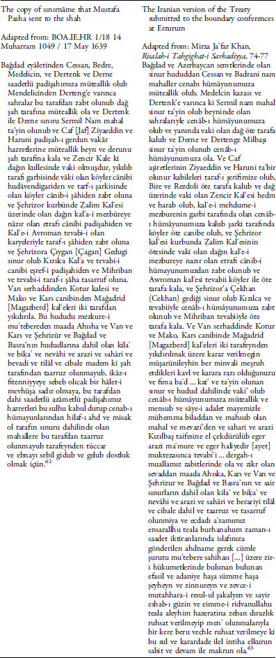
On close inspection, despite minor differences, like the Iranian copy not mentioning parts of the Jaf tribes left to Iranian suzerainty, the sections of the texts dealing with the locations are very similar to each other, if not identical. The other sections of the texts have significantly different wording, which makes them suspicious at best.
Another Ottoman document from the same Ibnülemin Hariciye collection of the Ottoman Archives but from a copy that was produced in 1675, and also purporting to be a copy of Mustafa Pasha’s letter, does not mention Ahiska, Kars, Van, Shahrizur, Baghdad, or Basra, or the shah’s intervention in their affairs. However, it affirms that the sultan and his subjects would respect the peace and not mistreat those places lying within the limits of the other side.Footnote 64 A striking aspect of these versions of the treaty that are reproduced at different times and kept in the Ibnülemin collection is that they contain no reference whatsoever to the religious animosity existing between the parties.
While these versions, and the above-quoted text of Naʿîmā, do not mention the Safavid use of irreverent language towards the companions of Prophet Muhammed and his wife Aisha; that animosity is made obvious in yet another version reproduced in an Ottoman collection of imperial letters (Nāme-i Hümāyūn Defteri) purportedly copied in 1731, as well as in the version produced by the Iranian and Ottoman delegates to the Erzurum conferences. Despite its florid language, this Ottoman copy of the imperial letter reads like a modern-day pamphlet about the party line. Emphasizing the fact that the shah had sent envoys soliciting peace, the sultan stresses his following the path of sunna; his leadership in carrying out gaza and jihad against the infidels and mushrikin (those who associate other beings with God, a serious sin in Islam, and a not-so-veiled reference to the Shia); his roles as caliph and servant of the two holy places; and his guarding the frontiers of Islam and maintaining peace among the Muslims (rutbe-i āliye-i saltanat-ı kübra ve tabaka-i sāmîye-i hilāfet-i ulyāmızı ve hizmet-i haremeyn-i şerîfeyn). Like the sultans before him, he furthermore declares that the treaty will be everlasting only when the cursing or irreverent and offensive language towards the first three caliphs, the prophet’s wife, the companions of the prophet, and the Sunni faith ceases.Footnote 65 Emphasizing non-interference in the affairs of the lands left to each party, the parts of the document dealing with the division of lands are almost identical to the copy the Iranian plenipotentiary delivered to Erzurum conferences.
As the documents listed here show, when the international commissioners sat down to figure out the limits of the Ottoman Empire and Iran, they soon realized that despite some general principles there was absolutely no agreement on what constitutes the original boundaries of the Ottoman Empire and Iran. Consequently, instead of relying on as vague a document as what purported to be the treaty of 1639, the commissioners accepted the status quo, and followed the principle of uti possidetis (that is territory remains with its possessor) in their decision making. The 1639 treaty turned out to be a confusing document for the most part.
This confusion became even more acute when the southern borders of the two states were discussed. The 1639 Treaty made clear that the southern limit of the sultan’s domains was Basra, which, as Rudi Matthee and Metin Kunt in different studies have shown, did not come under Ottoman control for a very long time.Footnote 66 There is no clause whatsoever in the 1639 Treaty about where the boundaries of Basra (or Ahiska, or Baghdad, etc.) were. It simply notes that Basra belongs to the sultan. However, throughout the long process of delimiting the Ottoman–Iranian frontier in the nineteenth century, the Basra-Muhammara and the adjacent Shatt al-Arab area emerged as the most intractable problem of boundary delimitation. Even if the Tārih-i Naʿîmā text presents a true abstract of the treaty, a difficulty in those parts of the frontier was that the treaty did not mention any places between Basra and the Mandali, Jassan, Badra, and Zurbatiyeh regions, a distance of well over 300 miles. The 1639 treaty contained only a general allusion to Basra and its dependencies as the southern limit of the Ottoman Empire.Footnote 67 Moreover, the limits of Basra province depended on the power of the individual chief or tribe dominating sections of what could be considered a boundary. At the time of the signing of the Zohab treaty, the land in between—that is, the large marshes—was under the authority of the Mushasha Arabs, whose chiefs at times held Basra in fief from the sultan. Hence the limits of their territories defined the limits of the sultan’s imprecise frontiers. However, later on mostly independent Muntafik tribes dominated the Basra region, together with the Banu Lam to the east. As those tribes lived in virtual independence at the time of the making of the Erzurum Treaty of 1847, the terms of 1639 made almost no sense for the current conditions. Here, and in the Kurdish-inhabited lands to the north, the limits of the shah’s and sultan’s authority was based on the suzerain relations that the ruler or the ruling dynasty had with the local aristocracy. Sovereignty was not based on territorial limits but the limits of local dynasty or the tribe recognizing the suzerainty of the shah or the sultan. The process that started in Erzurum in 1843 brought this phase of sovereignty to an end, replacing it with sovereignty based on clearly defined, internationally recognized territorial limits.
Examining available versions of the 1639 document, the conferees at Erzurum, like the survey commissioners that followed them, tried to locate the places listed in various versions of the text. However, the disparity between the hudud-u kadime, or the old border, and the hudud-u haliye, or the existent border, proved difficult to reconcile. This difficulty was further compounded by Tehran’s and Istanbul’s clashing ambitions and the borderlanders’ sectarian affiliations. Two centuries of intermittent conflict and competition, modifications to the balance of power, frequent and sometimes considerable migrations, conversions, considerable environmental changes, diseases, and other factors had indelibly altered the world of the borderland and its imaginable or imagined limits. When it came to border delimitation and demarcation, the 1639 Treaty proved, at least in many parts of the border, a myth rather than a foundational document.
The almost six-year-long labors of the Erzurum Congress/Conferences and the survey commission that traversed the boundary between 1848 and 1852 were not enough to finalize the Ottoman–Iranian boundary. Many other international or bilateral commissions followed in their wake. I have elsewhere emphasized that the Ottoman–Iranian boundary as we know it today represents the nineteenth-century balance of power between the Ottoman Empire, England, and Russia, rather than the balance of power between Iran and the Ottoman Empire or the 1639 Treaty.Footnote 68 Hence, when the Russo-Japanese war shook this balance, Istanbul did not hesitate to occupy northwestern Iran. Beginning in 1905, in defiance of the work of various frontier commissions, Ottoman troops, in cooperation with some of their co-religionist Sunni Kurds, started gradually occupying the Sunni Kurdish districts of Iran, supposedly as a buffer against Russian expansion. However, soon afterward Russia and Britain agreed to divide Iran into spheres of influence, when Germany was trying hard to make inroads into the region. On top of such rivalry, during an international crisis sparked by the Italian occupation of Ottoman Libya (1911) and following the Balkan Wars that exhausted the Empire, the Ottoman troops unceremoniously left northwestern Iran. Russo-British vital interests demanded the adjustment of the frontier, and once again the balance of power between imperialist powers became the determining factor in Ottoman–Iranian relations rather than the power balance between Tehran and Istanbul. As a result, Istanbul, London (and St. Petersburg) started directly negotiating the situation on the border region and the final shape of the boundary. London and Istanbul established the Shatt al-Arab Navigation Commission, which finalized the division of the most contentious part of the boundary with no Iranian participation. Realizing that the Ottomans and Iranians would never be able to agree on the location of their mutual boundaries, the two mediators to the frontier negotiations and at the time masters of Iran, Britain and Russia, forced them to accept the formation of a final boundary commission, with the power of arbitration belonging to the Russian and British commissioners.
It was this power of arbitration that finalized the boundary, and not the reliance on the 1639 Treaty or the Ottoman and Iranian claims that were leading nowhere. The last frontier commission, with the later famous scholar of the Iranian world Vladimir Minorsky as the Russian commissioner, worked from mid-December 1913 to lat|e October 1914 to finalize the demarcation of the frontier. The last frontier commission, which included a token Persian commissioner as well, worked from 21 January 1914, to 28 October 1914, and swiftly arbitrated the new frontier line. On 3 August 1914, just as their work was coming to an end, they received news of the outbreak of war in Europe. Unlike previous commissions that disbanded when given similar news, this one accelerated its efforts. Unable to solve the enduring case of Kotur, the now-dwindling commission proceeded to the final sections of the border. In spite of snowstorms and other obstacles, they signed the last protocols and maps not far from Bayezid, at the foot of Mount Ararat, on 27 October 1914. A final session was held the following day. Thus, the long transformation of the Ottoman–Iranian borderland into a boundary came to an end. Two hundred and twenty-three boundary pillars that were erected over 1,200 miles marked the labors of this final commission, and the limits of the domains of the shah and the sultan. Most of the pillars the boundary commission erected were soon destroyed by the local populations. Such efforts, however, were to no avail. The boundary was etched in black and white and made part of an international order that couldn’t care less for such nuisance.
Conclusion
Given that history, the 1639 Treaty fits well into the historical pattern of the global transformation of territoriality. It is a significant step in the evolution of ideas about borders and territorial sovereignty. Very much like the 1555 Treaty of Amasya, which should be taken as the foundational treaty (if there is going to be one), coinciding with the Peace of Augsburg; remarkably, the 1639 Treaty precedes another seminal treaty that was signed about a decade later, the Westphalian Settlement of 1648. This settlement has been interpreted as the birth of the modern international order based on sovereign states.Footnote 69 Very much like the Ottomans and Iranians, after thirty years of war (1618–48) in which religion played a primary role, the European states established what has been called the Westphalian state system of 1648. One major difference between Westphalia and Zohab was that the first was the result of negotiations among a large number of actors from across Europe, while Zohab was basically postwar negotiations that endorsed the treaty of 1555 regarding the frontiers. It would not be far-fetched to suggest that these processes, just like the Amasya Treaty of 1555, were part of an intercontinental phenomenon that encompassed western Europe and Eurasia. Thenceforward, territorial sovereignty would gradually evolve through hegemony defined by suzerainty, and the slow and painful secularization of frontiers and relations would gain ground. The change would not be immediate. The 1639 treaty was not a leap in the mutual relations of the parties. While the Westphalian settlement offered “a ‘Christian, general, and permanent peace’ intended to establish a lasting friendship across the continent … [and] offered a new charter for European relations,”Footnote 70 the 1639 treaty did not bring a new understanding to the mutual relations. Nevertheless, it strongly discouraged cross-border movements across a vaguely defined frontier, and thus made territorial sovereignty part of the discussion about borders. By making the definition of serhad and sınur the goal of the treaty, and making peace and non-interference conditional upon respect for borders, the treaty was a considerable step toward the idea of indivisible sovereignty.
As Peter Wilson argues, one of the common misconceptions about Westphalia is that by bringing peace it took religion out of politics. Despite the fact that in the long run it promoted secularization, it was not a fully secular peace.Footnote 71 At the level of detail and the issues it covered, the Zohab Treaty cannot be compared to the Westphalian settlements where the issue of rights, toleration, and compromise were extensively discussed. Perhaps due to the lack of any meaningful discussion of confessional issues, except maintaining that the companions of Muhammad not be cursed, and veiled accusations of Shia hereticism, we do not have any resolutions on religious differences and how to manage divisions that run deep. That would only come to Middle Eastern diplomacy through Nadir Shah’s efforts that would, unfortunately, bear no fruit. One of the major differences between the two treaties was that, due to the Papacy’s official refusal to acknowledge the existence of heretical powers and refusal to even negotiate in the same city lest it tacitly recognize their existence, the settlements of Westphalia were signed in two different cities.Footnote 72 The Treaty of Zohab, on the other hand, took place in the relatively warm environment of the Ottoman grand vizier’s camp, where the usual pomp of high-level ambassadorial deputations was on full display. Nevertheless, amicable dialogue and displays of friendship did not bring an amicable settlement to the deep fissures that still divide the post-Ottoman and Safavid geographies.


