

Introduction
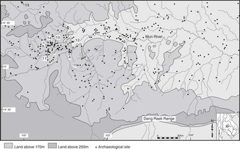
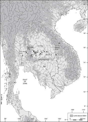
On 19 December 1906, Prince Damrong Rajanubhab, when Minister of the Interior, visited and described a large, uninhabited mound in the upper Mun Valley of north-east Thailand, called Non Muang Kao.Footnote 1 The name translates as ‘Mound of the Ancient City’, and this site is one of hundreds of moated prehistoric settlements that concentrate in the valley of the Mun River and spill over north into the Chi valley and south over the Dang Raek range, into northern Cambodia (figs 1 and 2). Following the Second World War, Peter Williams-Hunt took a series of air photographs of these settlements and published a report in Antiquity. He avoided speculating on their age, concluding that ‘The excavator's spade alone will provide the final answer’.Footnote 2 This paper is intended to point towards some answers and to contribute to our understanding of the late prehistory of the Mun Valley and the transition into early states.
The Mun Valley, showing the distribution of moated sites: 1. Noen U-Loke; 2. Ban Prasat; 3. Ban Tamyae; 4. Phimai, Ban Suai, Non Ban Kham; 5. Ban Takhong; 6. Ban Don Phlong; 7. Non Yang; 8. Non Krabuang; 9. Non Dua; 10. Ban Lum Khao; 11. Non Muang Kao; 12. Non Ban Kham; 13. Non Tung Pie Pone; 14. Ban Non Wat; 15. Muang Phet

Map of Thailand, showing the location of the sites mentioned in the text: 1. Sepon; 2. Ban Non Wat; 3. Noen U-Loke; 4. Non Muang Kao; 5. Khao Wong Prachan Valley; 6. Ban Don Ta Phet; 7. Khao Sam Kaeo; 8. Wat Phu; 9. Phimai and Ban Suai; 10. Ban Tamyae; 11. Ban Prasat; 12. Non Dua; 13. Ban Krabuang Nok; 14. Ban Takhong; 15. Non Yang; 16. Ban Don Phlong; 17. Muang Phet; 18. Muang Sema; 19. Si Thep; 20. Angkor; 21. Ayutthaya; 22. Hin Khon; 23. Wat Ban Song Puay

The cultural background
The spread of rice- and millet-farming communities from China into south-east Asia took place in the early second millennium bc, resulting in interaction with the indigenous hunter-gatherers. In the Mun Valley, the earliest evidence for Neolithic settlement comes in the seventeenth century bc at the site of Ban Non Wat.Footnote 3 The new settlers brought a fully developed agricultural economy, together with an established technology that involved fine ceramics, weaving and polished stone artefacts.Footnote 4 Long-distance exchange links brought marine shell ornaments well inland, and it was probably through the movement of specialists along natural riverine routes that the knowledge of bronze casting percolated through south-east Asia, seeing the establishment of copper mines in central and north-eastern Thailand and at Sepon in Laos.Footnote 5 The transition into the Bronze Age at Ban Non Wat took place in the late eleventh century bc and heralded a sudden and dramatic rise in mortuary wealth, expressed in exotic marble and marine shell jewellery and bronze ornaments and tools, particularly socketed axes.Footnote 6
The last two Bronze Age phases saw a sharp reduction in mortuary wealth, with very few bronzes being placed in graves. However, at this site, there was a seamless transition from the terminal Bronze Age cemetery into graves of the initial Iron Age, making it possible to identify changes that came with the adoption of iron technology.
This transition took place in the fifth century bc and involved the opening of extensive maritime exchange routes between south-east Asia, India and China. Naturally, it was coastal communities in south-east Asia that felt the full force of this development. At Khao Sam Kaeo, in peninsular Thailand, a trading port and manufacturing centre grew to cover 54 hectares. The centre incorporated walled areas and the local manufacture of glass and hard stone jewellery that, beyond reasonable doubt, involved resident Indian specialists.Footnote 7 The cemetery of Ban Don Ta Phet, likewise, contained objects of clear Indian or possibly Burmese origin, including etched carnelian beads, a carnelian lion and high-tin bronze bowls.Footnote 8 While the Mun Valley is distanced from direct contact with maritime exchange, the presence there of a new range of ornaments fashioned from glass, agate and carnelian, together with the knowledge of iron smelting and forging, shows that it, too, came into the orbit of foreign stimulus. This then, represents a classic instance where the impact of sophisticated state societies on socially less complex communities can be evaluated.
Previous research
In 1993, Rachanie Thosarat and I formulated a research programme designed to address the nature of prehistoric societies within the area that was to become the kingdom of Angkor. At that juncture, there had been few and limited excavations in the moated sites of the Mun Valley, which was a significant part of the Angkorian kingdom. The Mun Valley is as large as southern England and, in 1993, the handful of excavations were restricted to small test squares. Welch and McNeill had undertaken a site survey in the region of Phimai and identified many Iron Age settlements on the basis of a distinctive ceramic known as ‘Phimai Black’.Footnote 9 Most concentrated on the alluvial plain, now largely given over to rice cultivation, while smaller sites were found on the elevated old terraces where rice in bunded fields is rarely successful. Excavations at the site of Ban Tamyae provided a sequence which Welch divided into four phases.Footnote 10 The Tamyae phase pre-dates 600 bc, and was followed by the Prasat phase, with the first evidence for iron working between 600 and 200 bc, followed by the Classic Phimai (200 bc–ad 300) and the Late Phimai (ad 300–600). He concluded that this sequence involved population increases and the centralization of political authority in the Phimai area, where the site of Ban Suai underlies part of the Angkorian city.Footnote 11 The size of the moated sites was also examined by Moore, who suggested that there are three groups, covering respectively up to 20 hectares, from 21 to 40 hectares and up to 68 hectares.Footnote 12
Excavations on a limited scale at several sites were unanimous in revealing a relatively lengthy prehistoric occupation. Ban Suai was first investigated in 1966,Footnote 13 while a further excavation took place in 2001.Footnote 14 It is a deeply stratified mound dating throughout the Iron Age. A possible ritual structure was found in the first excavations, comprising a clay floor with ceramic vessels placed at the corners. Ban Prasat is located 14km west of Phimai and excavations there uncovered, first, an Iron Age cemetery, below which were richly endowed Bronze Age burials.Footnote 15 At Non Dua, settlement was under way by the early Iron Age.Footnote 16 Ban Krabuang Nok has a stratigraphic sequence 8.5m deep and again dates back into the Iron Age.Footnote 17 The initial occupation phase is dated between 300 bc and ad 200, followed by a phase that lasted until about ad 900, during which jar burial was the preferred means of interring the dead. Ban Takhong was occupied during the Iron Age.Footnote 18 This moated site has a cultural stratigraphy 6m deep, and excavations uncovered clay floors and wall foundations. The mortuary ritual involved interment in jars placed mouth to mouth, although one unique burial in the lower layers involved a kneeling skeleton associated with ceramic vessels and a glass ornament. Another remarkable burial involved a large mortuary vessel placed over a turtle carapace.
Excavations at Non Yang, which is located on the bank of the Mun River, revealed eight cultural layers.Footnote 19 These included Iron Age jar burials, ceramics similar to those at Non Dua to the east, and much evidence for structures in the form of clay floors plastered over a foundation of split logs, with walls constructed of wattle and daub. These date to the last three centuries bc. Ban Don Phlong is a large Iron Age settlement within three moats. The sequence began with a cemetery in which the dead were interred in wooden coffins that were placed within clay-lined graves. Grave goods included bronze bangles and ornaments of glass and agate. The upper context comprised the remains of furnaces for smelting iron ore and forging iron artefacts.Footnote 20
The first attempt to date the moats and banks was undertaken by Welch and McNeill at Muang Phet, a site already examined by Quaritch-Wales.Footnote 21 They identified prehistoric potsherds within one of the banks and obtained two radiocarbon determinations that spanned the bank construction. These indicated that they were constructed in the fourth or fifth century ad.Footnote 22
These excavations, all of which were of limited extent, illustrate the promise that these moated sites present for the prehistorian interested in the origins of complex state societies in mainland south-east Asia. There is thus evidence for the presence of exotic mortuary offerings, of complex rituals of death, the local production of iron and salt, and the considerable growth in the size and the number of sites. The challenge of opening larger areas, and finding out more, was taken up with our ‘Origins of Angkor’ project.
The ‘Origins of Angkor’ Project
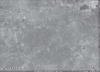
Illuminating the prehistory of these sites began by selecting a discrete study area in the upper Mun Valley and then compiling a distribution map of all the sites. This was undertaken on the basis of aerial photographs and walking over much of the terrain (fig 3). We then selected three sites for excavation. Noen U-Loke lies within at least five moats and banks and the mound within these has a maximum diameter of 410m. A small test square undertaken by Wichakana had encountered a 4m-deep cultural sequenceFootnote 23 and we decided to excavate the adjacent area. Non Muang Kao is one of the largest sites with a maximum diameter of 650m, while Ban Non Wat is ringed by at least two moats and banks and has a diameter of 330m. We had several major objectives in undertaking these excavations. The first was to establish a tightly dated cultural sequence. We then wished to identify and explain any social changes that occurred over the period documented. In the event of recovering human mortuary remains, we wished to characterize the demography, the health and the origins of the populations. It was necessary to examine the surrounding earthworks to establish their form, function and chronological relationship to the overall sequence. It was clearly vital also to obtain information on the palaeoenvironment and how it might have changed over the prehistoric period. In sum, we then knew virtually nothing relating to the matters we were interested in.
Aerial view of Ban Non Wat relative to other moated sites: A. Ban Non Wat; B. Noen U-Loke; C. Non Muang Kao; D. Ban Ko Hong

The Palaeoenvironment
The Mun is the major river that drains the southern half of the Khorat Plateau. It rises in the Petchabun Range and, augmented by many tributaries, flows eastwards to join, first with the Chi, and then the Mekong. It thus forms a highway for exchange between central Thailand and the lands bordering the Mekong. This location has recently taken on a new significance with the discovery, beyond the Mekong in Laos, of a major Iron Age copper-mining complex at Sepon. The terrain is relatively flat, comprising the broad flood plain of the river, flanked by a series of slightly elevated terraces. Apart from extensive land suited to rice cultivation, the Mun Valley is a major source of salt.
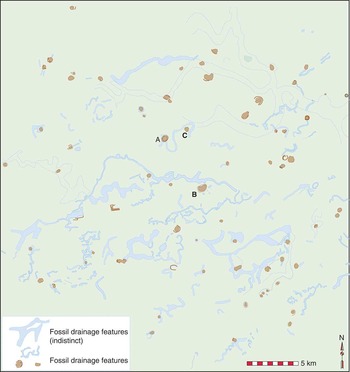
In their analysis of palaeoenvironmental change in this region, Habberfield-Short and Boyd have identified six phases, of which the fifth is relevant to Iron Age settlement.Footnote 24 Phase 5A covers the late Bronze Age, which ended in the fifth century bc. Settlements were located on elevated tracts near single-channel rivers. This was a period of reducing rainfall. With phase 5B, from 500 to 200 bc, the river system, judging from the analysis of air photographs, converted to multiple, narrow channels. Phase 5C represents the later Iron Age from 200 bc to ad 500, when a decline in rainfall stimulated human management of water through the construction of banks round the settlements that filled with water fed by stream inflows. The distribution of sites and the reconstructed course of the rivers within the study area are set out in Figure 4. The results of pollen analyses suggest that there were at least six phases of vegetation change during the course of the Iron Age, beginning with increasing encroachment into the natural cover, which is predominantly dry, deciduous dipterocarp forest. This forest clearance accelerated as more land was brought under rice cultivation, the deforestation doubtless contributing to the changing water regime and increasing sedimentation.Footnote 25
Location of archaeological sites and former river channels, as mapped from the 1:42,000 aerial photography taken in 1954/5: A. Noen U-Loke; B. Non Muang Kao; C. Ban Non Wat

The cultural sequence and chronology
Ban Non Wat has the longest cultural sequence of all three sites examined.Footnote 26 There are twelve phases, determined largely on the basis of superimposed mortuary remains. The last three of these phases fall into the Iron Age. The radiocarbon determinations for this sequence have been obtained on the basis of freshwater shellfish, placed as offerings with the dead, and charcoal from assured contexts. The earliest Iron Age burials follow seamlessly from the late Bronze Age cemetery. Their density suggests a relatively lengthy duration of the Iron Age (IA) 1, with the transition from the late Bronze Age beginning in the late fifth century bc. The second phase, IA 2, is represented by a handful of burials that belong within the period 100 bc–ad 300 and the last phase, which contains typical late Iron Age Phimai Black ceramics, is dated to the period ad 400–600. A more precise dating of the Iron Age is made difficult by the effect of the Hallstatt Plateau on calibrations.Footnote 27
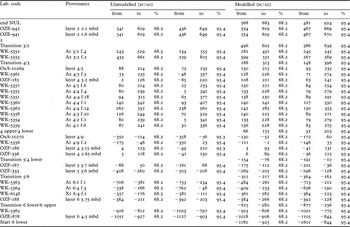
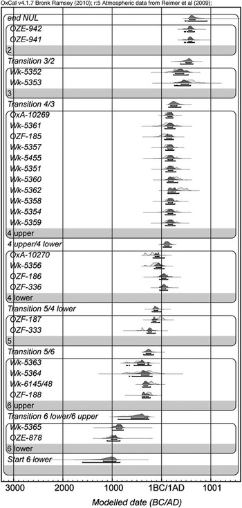
There are four Iron Age cultural phases at Noen U-Loke. They span the entire Iron Age sequence, and are richly represented by burials and occupation remains. The occupation and mortuary sequence at this site has been dated on the basis of twenty-seven radiocarbon determinations (table 1; fig 5). Those dated in the Waikato laboratory come from mixed charcoal samples obtained from hearths and furnaces within the occupation layers and must therefore be regarded as termini post quem, due to the problem of unknown inbuilt age. The two Oxford dates come from resin that coated potsherds and are therefore more likely to be reliable. The Australian AMS series is derived from samples of charcoal extracted from the sections after the excavation was complete. These may also have inbuilt age. It is recognized in retrospect that these are less than satisfactory. They have, however, been evaluated using Bayesian methods, with provision for the likelihood that the charcoal dates indeed have inbuilt age (fig 5). The mortuary sequence of four phases is dated by relating the depth of the burials to the contexts of the radiocarbon determinations.
The radiocarbon determinations for Noen U-Loke. All are based on charcoal except for Ox-A 10269–70, which are on the basis of resin from prehistoric pots

Probability distribution of dates relating to the cultural sequence of Noen U-Loke (OxCal v4.0.5: Bronk Ramsey Reference Bronk Ramsey2001); at 68.2 per cent, and 191–10 bc at 95.4 per cent probability (5IntCal04 atmospheric curve: Reimer et al Reference Reimer, Baillie, Bard, Bayliss, Beck, Bertrand, Blackwell, Buck, Burr, Cutler, Damon, Edwards, Fairbanks, Friedrich, Guilderson, Hogg, Hughen, Kromer, McCormac, Manning, Bronk Ramsey, Reimer, Remmele, Southon, Stuiver, Talamo, Taylor, van der Plicht and Weyhenmeyer2004)

Mortuary phase 1 burials were found in layers 5 and 6. In the case of burials 26 and 27, the grave cuts were identified on the surface of layer 5, meaning that they belong to lower layer 4. The transition from layer 5 to lower layer is dated to 154–76 cal bc at 68.2 per cent and 191–10 bc at 95.4 per cent probability. The earlier part of the range is preferred, given the similarity between the material items with the graves and the late fifth-century bc date for the commencement of mortuary phase 1 at Ban Non Wat. However, there are many burials in the latter group and the later ones could well belong in the third or second centuries bc.
Mortuary phase 2 burials were laid out in tight clusters and found lying on the surfaces of layer 4:7–11. We did not identify any grave cuts so there is no indication of the depth from which they originated. However, upper layer 4 is the most likely part of the sequence from which they were cut. The transition from lower to upper layer 4 is 66–155 cal ad at 68.2 per cent and 32–203 cal ad at 95.4 per cent probability. The transition from upper layer 4 to layer 3 is dated to 188–313 cal ad at 68.2 per cent and 148–336 cal ad at 95.4 per cent probability. IA 2 thus probably dates within the period 100 bc–300 ad. IA 3 burials were found in upper layer 4. In the case of burials 75 and 105, the clay capping to the grave was recognized in lower layer 3. As we have seen, the transition from layer 4 into 3 has been dated between 148–336 cal ad, meaning that the third mortuary phase can be placed in the third and fourth centuries ad. Finally, IA 4 burials are found in upper layer 3, implying that the graves were cut from layer 2. The transition from layer 3 to 2 has been dated from 496–605 cal ad at 68.2 per cent and 386–639 cal ad at 95.4 per cent probability. It is therefore suggested that these burials belong within the span ad 400–600.
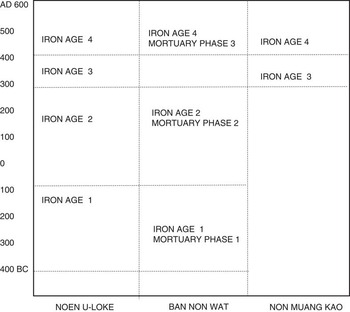
The relationships between the phases at these two sites is summarized in Figure 6, which is based on the typology and range of items placed with the dead. This figure also illustrates the relatively late period represented by the small area opened at Non Muang Kao.Footnote 28 These sites, taken in conjunction, represent the entire sequence of Iron Age occupation in the upper Mun Valley and thus provide an opportunity to trace cultural development over a period of about 1,000 years.
The sequences and chronological framework for the Iron Age in the upper Mun Valley, north-east Thailand

The people of Noen U-Loke
The human remains from Noen U-Loke have provided the first opportunity in south-east Asia to assess the health and demography of an Iron Age population,Footnote 29 although the sample size for each of the phases is too small to permit a detailed review of changes over the millennium involved. The sample as a whole comprises 120 individuals, of which fifty-three died when less than fifteen years of age, 70 per cent of this group being from pre-term to less than one year of age. Of the mature individuals, four were probably aged from fifteen to nineteen years at death, while twenty-four are classified as young adults, fourteen as mid-adults, twelve as old and thirteen cannot be classified. More than half of all the adult males belong in the young adult category. The average stature for women was 154.6m and for men, 169.3m. The women were of similar height to the early Bronze Age population at Ban Lum Khao, but the men were significantly taller then their predecessors. Overall, the adult population were in reasonably good health, with less evidence for growth disruption in childhood than during the Bronze Age at Ban Lum Khao.Footnote 30 However, two individuals suffered from leprosy, and tuberculosis might well have been present. One child suffered from cerebral palsy. Evidence for bone trauma from violence is found in one woman, who died when her head was violently attacked with a sharp instrument, while a young man from the final mortuary phase was killed by an arrow that pierced his spine.
The bones suggest a population that did not face malnutrition, despite the demographic evidence for a rising population. There is a consistent body of evidence for a healthy diet during the Iron Age. Rice, for example, was found in considerable quantities at Noen U-Loke, where surpluses were used in the second and third mortuary phases to fill the graves and mortuary vessels. Feasting is suggested by the regularity with which the severed limbs of pigs – and on occasion whole pigs – were placed in graves. Pottery vessels used as mortuary offerings often contained fish skeletons. Cattle and water-buffalo bones also accompanied the dead. In the occupation layers, we found butchering floors littered with the discarded bones of cattle, pigs and water buffalo.
The faunal spectrum of Noen U-Loke reveals not only the dominance of domestic bovids, pigs and water buffalo, but also a regular occurrence of large, medium and small-sized deer.Footnote 31 Shellfish, now adapted to rice fields, are abundant in all layers, with over 24,000 coming from the gastropod Filopaludina and 4,618 from the large species Pila ampullacea. Fish remains from occupation layers were also present and reflect the local presence of ponds and rivers. The moats would doubtless have been a further source of aquatic food.Footnote 32
The mortuary sequence
Iron Age 1: 420–100 bc
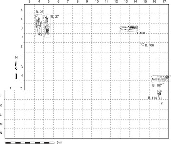
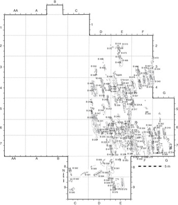
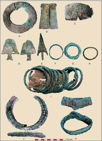
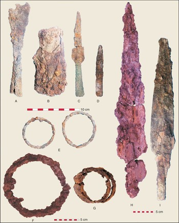
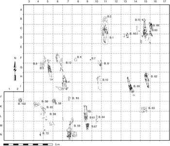
The initial Iron Age is documented by six burials at Noen U-Loke and 125 at Ban Non Wat (figs 7 and 8). The dead were normally interred in a supine position accompanied by a variable range of mortuary offerings. At the former site, two men were found buried alongside each other but in opposite directions. They were undisturbed and illustrate a complex mortuary ritual. Each lay in a supine position with the hands by the side. Pottery vessels, closely matched in form at the corresponding phase at Ban Non Wat, contained food remains: complete fish skeletons and pig and turtle bones. The severed foot bones of pigs were placed with each man. Bronze was used for ornaments: bangles and neck rings (fig 9: J and K), as well as for socketed spears. One man was accompanied by a large socketed iron spear (fig 10: H) and an iron hoe. He also wore shell discs, probably inserted into distended ear lobes, and four tiger's canines bored for suspension round the neck. The second man wore two similarly bored pig's tusks. An old woman in this same phase wore two iron bangles on each wrist, and a neck ring of iron (fig 10: F and G). Bronze was used for ornaments: bangles and neck rings (fig 9: J and K), as well as for socketed spears.
The layout of graves belonging to Noen U-Loke Iron Age 1

The layout of graves belonging to Ban Non Wat Iron Age 1

Bronze artefacts placed with the dead during Iron Age 1: A. Ban Non Wat, burial 314, anklet; B. burial 343, bangle; C. burial 382, bangle; D. burial 482, socketed implements; E. burial 477, arrowhead; F. burial 345, bangle; G. burial 489, bangle; H. burial 481, bangle; I. burial 485, bangles; J. Noen U-Loke, burial 27, three torcs; K. Noen U-Loke, burial 27, bangle

Iron artefacts from Iron Age 1 burials: A. Ban Non Wat, burial 348, socketed chisel; B. burial 341, socketed hoe; C. burial 390, bimetallic spear; D. burial 341, point; E. burial 356, bangles; F. Noen U-Loke, burial 108, torc or neckring; G. burial 108, bangles; H. burial 27, socketed spear; I. Ban Non Wat, burial 374, socketed spear

The IA 1 cemetery at Ban Non Wat was contiguous with the late Bronze Age graves. While ceramic vessels and the orientation of the body remained the same, the presence of iron mortuary offerings signals the transition into the Iron Age. The structure of the cemetery reveals two rows, one having the burials orientated with the head to the north, the other to the south (fig 8). Both contained the graves of men, women and young individuals. Similarity in mortuary offerings and rituals argues against these being sequential; rather, they were two different groups within the same Iron Age community.
It is not possible to offer a precise correlation between these graves and those of IA 1 at Noen U-Loke, and there are some important distinctions between the two sites that might be chronological or, alternatively, due to the small sample size for the latter site. Common features include the provision of large pottery vessels containing complete fish skeletons, as well as the severed limbs of pigs. At Ban Non Wat, water-buffalo and cattle bones were also found on occasion. There are similarities, and some differences, in the iron artefacts found. Spears and bangles are present at both sites but at Ban Non Wat there were also kits of thin-bladed knives, awls and possibly other small tools, formerly contained in cloth bags, to judge from pseudomorphic fabric remains. Bronzes were relatively rare. There were plain bangles (fig 9: I) and, in the case of two infants, technically demanding anklets and bangles bearing decoration cast through the lost-wax procedure (fig 9: A and B). Three men were accompanied by spears with a bronze socketed haft and an iron blade (fig 10: C). There were also two thin socketed bladed artefacts of unknown use, but which are precisely matched in moulds from the Khao Wong Prachan Valley in central Thailand (fig 9: D), and an arrowhead (fig 9: E).
Glass in south-east Asia is usually seen as a signal for the commencement of maritime exchange with India and Burma. The early Iron Age phase at Ban Non Wat included a handful of individuals wearing glass ear ornaments. Burial 356 also wore a necklace containing a glass, carnelian and an agate bead. Many people were also accompanied by spindle whorls and caches of grey clay. The former were used for processing yarn, while clay is used to this day for dyeing cloth. Clearly, the production of fabric was being undertaken by the occupants of Ban Non Wat.
Iron Age 2: 100 bc–ad 200
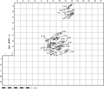
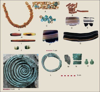
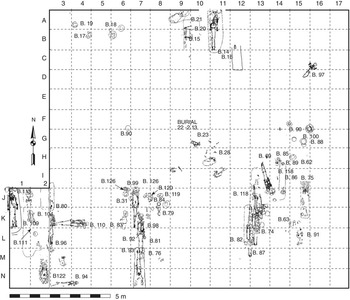
The second phase of the Iron Age is represented by two tightly clustered groups of burials at Noen U-Loke (figs 11 and 12). The earlier group comprised the graves of two men, two women, a child and an infant. They wore the first glass beads to be found at this site, as well as an agate pendant, some beads of shell and bronze finger rings. Two people were interred with complete pig's skeletons. The later and larger group lay just to the south, and we find in it a number of singular changes, particularly the rice-bed burials. This technique involved placing the corpse in a grave filled with white burnt-rice husks, referred to below as silicified rice. The bones, when encountered, were covered in rice. Long, faceted carnelian beads were restricted to this cluster (fig 12: H and I). Other jewellery included strings of glass beads (fig 12: A, B and C), agate beads and pendants (fig 12: D, E, F, G and J) and bronze toe and finger rings (fig 12: M and N). A bronze spiral ornament was found on the head of a young man (fig 12: K). There were no iron offerings and very few pottery vessels.
The layout of graves belonging to Noen U-Loke Iron Age 2

Mortuary offerings from Noen U-Loke Iron Age 2 burials: A. burial 37, glass beads; B. burial 53, glass beads; C. burial 23, glass beads; D. burial 37, agate pendant; E. burial 35, agate pendant; F. burial 53, agate pendant; G. burial 40, agate pendant; H. burial 53, carnelian beads; I. burial 32, carnelian beads; J. burial 49, agate beads; K. burial 39, bronze head ornament; L. burial 30, bronze bangles; M. burial 30, bronze finger rings; N. burial 54, bronze toe rings; O. burial 54, bronze bells

Iron Age 3: ad 200–400
The structure of the IA 3 cemetery at Noen U-Loke again comprised tight groups of graves, each containing the remains of men, women, infants and children (fig 13). The ceramic vessels now belonged to the Phimai Black tradition. This was a period when the inhabitants of Noen U-Loke were active participants in a growing exchange network for exotic goods. These groups are so tightly nucleated that it is considered highly likely that they comprise related individuals. Any differences between their wealth and treatment, therefore, opens the possibility of exploring the social structure of this community during the later part of the Iron Age.
The layout of graves belonging to Noen U-Loke Iron Age 3

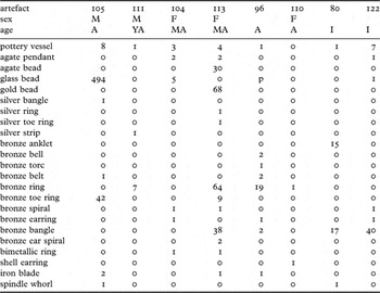
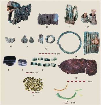
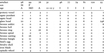
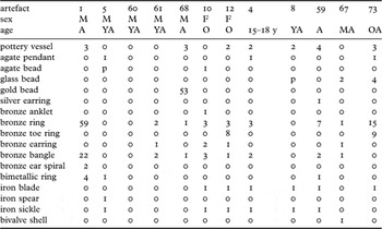
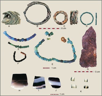
Group A comprises three men, three women, three adults of unknown sex and four infants (table 2). This supports the suggestion that the group comprises related individuals. The mortuary ritual involved digging a deep grave and lining it with clay. Many were also filled with rice. The relatively intact burials contained fine Phimai Black ceramic vessels. People were buried wearing a wide range of ornaments. Burial 113 involved a woman aged about twenty-five to thirty years at death. Her grave was lined and capped with clay and contained rice. This woman was interred wearing a necklace comprising sixty-eight gold beads and many agate beads (fig 14: L). She also wore two agate pendants at the neck. Four pottery vessels lay beyond the cranium. Her bronze ornaments comprised two ear spirals (fig 14: B), thirty-eight or more bangles (fig 14: C), sixty-four finger rings and nine toe rings. She wore a silver finger ring on her left hand and a silver toe ring on the left foot. Over her upper left arm, there lay an iron knife blade bearing the impressions of fabric. A bimetallic (bronze and iron) ring lay under her head. Burial 113 thus represents one of the richest interments of this site.
The mortuary offerings with relatively intact graves from Iron Age 3 group A

YA young adult; MA middle-aged adult; A adult; M male; F female; I infant
Mortuary offerings from Noen U-Loke Iron Age 3 group A burials: A. burial 105, bronze toe rings; B. burial 113, bronze ear coil; C. burial 113, bronze bangles; D. burial 113, bronze rings; E. burial 96, belt; F. burial 96, bell; G. burial 122, spiral; H. burial 113, anklets; I. burials 104 and 113, agate pendants; J. burial 113, agate beads; K. burial 105, iron knife; L. burial 113, gold beads; M. burial 105, glass beads

Burial 104 contained the remains of a twenty-five- to thirty-year-old woman. The upper part of her skeleton was found intact, but the lower limbs were in disarray, probably as a result of the later interment of burial 105. Therefore the scattered remains of pottery vessels in the vicinity of the foot bones are not in certain association. Three pottery vessels were found beyond the cranium, and she wore two agate neck pendants (fig 14: I). Other ornaments included a bimetallic ring, a bronze ear ring on the left ear and a bronze spiral, together with five glass beads in the area of the body.
Burial 96 was found almost intact in a grave filled with white burnt rice. A pottery vessel had been placed over the head, but when removed, it was found that an iron blade lay over the lower part of the face. This person wore at least one bronze torc and bronze rings, bells, bangles, a belt and at least one earring (fig 14: E and F). Infants were interred with considerable wealth. Burial 122, an infant who died when aged between three and nine months, was found in a rice bed with at least seven pots, an agate pendant at the neck and much bronze jewellery.
This cluster includes men, women and infants. The preferred orientation was north to south. Two females were interred with the head to the north and two men were buried with the head to the south. Men and women interred on opposing orientations were found in the late Bronze Age cemetery of Ban Na Di.Footnote 33 The graves were up to 900mm deep and cuttings, where they were identified, originated from lower layer 3. The bed of most graves was filled with rice burnt to a white colour and, in some cases, there was evidence for a clay lining, including a cap or cover. The mortuary ritual included the placing of a bowl over the face of the dead. This was not found in any other cluster. It is clear that earlier graves were on occasion disturbed and the bones were bundled and replaced, often in the grave fill of the subsequent interment. Infants were buried, often with a rich complement of grave goods, in the same manner as adults. Intact cluster A burials were accompanied by jewellery of gold and silver, agate and glass. Bronzes included earrings, torcs, bangles, anklets, finger and toe rings, bells and belts. Iron items comprised four knives, two bimetallic rings and a socketed hoe or axe. One knife was covered in pseudomorphic fabric, but only two spindle whorls were found, one with an infant and the other with a male.
Iron Age 3 cluster B
Iron Age 3 cluster B was found to the east of A with an intervening space of 3–4m. There are two adult men, one woman and two further adults (table 3). Thirteen graves contain the remains of infants, eight being pre-term or neonate, with one who survived to between three and nine months. Three died when aged between one and four years and there was a ten- to eleven-year-old. This is a remarkably high proportion of infants, their graves clustering round and over that of the relatively old woman.
The mortuary offerings with relatively intact graves from Iron Age 3 group B

YA young adult; MO middle-aged to old adult; A adult; M male; F female; I infant; y year
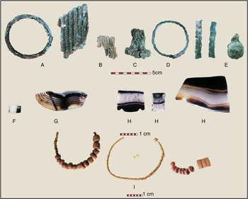
Burial 98, that of an adult male, lay in a bed of white, burnt rice. A pottery vessel lay over the cranium, and two spindle whorls were present, both on or near the left shoulder. Bronze ornaments incorporated nine bronze bangles (fig 15: A), seven finger rings and three spirals (fig 15: B). Six earrings were found to the right of the head and an iron knife blade lay in the area of the left hand. Some glass beads were also found by the head.
Mortuary offerings from Noen U-Loke Iron Age 3 group B burials: A. burial 98, bangle; B. burial 98, finger rings; C. burial 99, earrings; D. burial 79, anklet; E. burial 120, bell; F. burial 120, agate bead; G. burial 99, agate pendant; H. burial 129, agate pendants; I. burial 25, glass beads

Burial 99 contained the skeleton of a woman who died as a result of heavy cutting blows to the head that severed her skull. It is presumed that, following this violent death, she was taken to the cemetery and interred wearing her ornaments and other items. These included four spindle whorls, disposed two to the right and two to the left of the upper body. A complete pottery vessel was placed on the left shoulder. Bronze jewellery incorporated four bangles on the left wrist and seven on the right. There were eight key-shaped earrings on each ear (fig 15: C), a bronze ring by the neck and another by the left leg. She also wore an agate neck pendant (fig 15: G) and a glass bead.
The infant in burial 46 died when between eighteen months and four years of age. A bed of rice filled the base of the grave. Three pottery vessels were associated with the body, one above the head, one under the skull and the third to the left of the ankles. An iron knife blade was present below the feet and a second indeterminate iron artefact was found in the same area. Jewellery comprised an agate bead, a glass bead and two bronze bracelets. Burial 77, a late foetal or new-born infant, wore four bronze anklets, a bronze bangle and a bronze ring. A pottery vessel was also found in the grave. The grave of burial 79 contained the skeleton of an infant who died when aged about three to nine months. Grave goods included a pottery vessel and two bivalve shellfish. Bronzes incorporated two anklets on the right leg and three on the left (fig 15: D), and two bronze bangles on each arm.
The cranium of burial 81, a neonate, lay below part of a pottery vessel, and the bronze ornaments worn involved an anklet on each leg, four bronze bangles, a fragment of a finger ring and glass beads. Burial 120 comprised a very large burial jar containing the remains of a neonate interred with two further pottery vessels and, for jewellery, three agate pendants, an agate bead (fig 15: F), four bronze anklets on the left leg and three on the right, and a bronze bell (fig 15: E). Burial 25 was a rice-filled grave for a two- to four-year-old child interred with a pottery vessel, glass beads and two spindle whorls. The child also wore several bronze ornaments: an earring, bracelet, six anklets and a finger ring.
Burial 31 partially overlies burial 99. This was the grave of a child who died when aged about twelve years. The head lay over a pottery vessel. Bronze ornaments comprised a bangle on each arm, six rings and a spiral on the right hand, a long spiral on the other, and an earring on the left ear. An egg had been placed near the left hand. It is the size of a hen's or a duck's egg.
There is no stratigraphic evidence to provide a relative chronology for clusters B and A. This reflects the absence of a clay grave capping in cluster B graves, and hence difficulty in determining the depth from which the graves originated. The mortuary ritual remained basically similar in terms of orientation and the use of burnt rice husks to fill the base of the grave.
Unlike cluster A, there is no gold or silver jewellery, but other ornaments were similar, including the agate pendants, bronze bangles, ear and finger rings. This group, however, seemed to prefer placing the human head in or on a pottery vessel, rather than using one to cover the head. Iron knife blades were found in three of the burials. The woman of burial 99, who attained an age of more than forty years, was buried with four spindle whorls, and nine in all accompanied cluster B graves. This is a much higher frequency than for cluster A. The impression gained from the distribution of the cluster B graves is of a small core of adults and an exceptional level of infant mortality.
Iron Age 3 group C
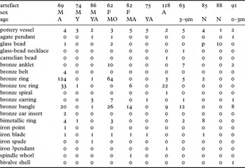
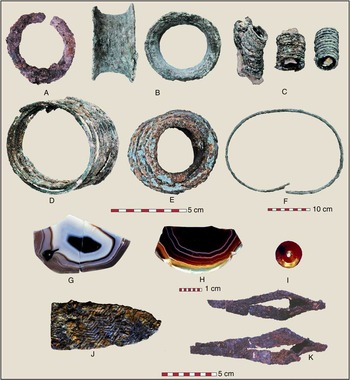
Iron Age 3 group C burials lay 4.5m to the west of group B (fig 16; table 4). There are three men, two women and four adults. Five of the burials are of late foetal or newly born infants, two survived to between one and nine months and there is also the grave of one child. Burial 69 contained a male with four pottery vessels and abundant bronze ornaments. Two large, circular plugs were found, one on either side of the skull, and their position suggests that they had been inserted into the ear lobes (fig 16: B). He also wore four bronze belts (fig 16: F). Nine bronze bangles were present on the left wrist and at least eleven on the right (fig 16: D). More than fifty-nine finger rings were present on the right hand and at least sixty-five on the left (fig 16: C). Toe rings were also abundant, particularly on the right foot, where more than twenty-six were recovered, compared with seven on the left foot (fig 16: E). Four bimetallic rings were recovered, two on the big toe of the left foot, another over the left femur and the fourth under the chin (fig 16: A). An iron knife blade had been placed to the right of the head and an iron point, possibly an arrowhead, was present under the leg.
The mortuary offerings with relatively intact graves from Iron Age 3 group C

M male; F female; A adult; Y young; MO middle-aged to old adult; YA young adult; N neonate; m month; p present
Mortuary offerings from Iron Age 3 group C burials: A. burial 69, bimetallic ring; B. burial 69, earring; C. burial 69, rings; D. burial 69, bangles; E. burial 82, toe rings; F. burial 69, belt; G. burial 13, agate pendant; H. burial 91, agate pendant; I. burial 118, carnelian bead; J. burial 85, iron knife; K. burial 118, iron artefacts

Burial 86 involved a male aged twenty-five to thirty years at death who was accompanied by a complete, socketed iron spade, covered in rice remains. It appears likely that the pot containing this spade had formerly been filled with rice grains. Burial 62 contained the complete skeleton of a woman who died when aged in the vicinity of thirty-five to forty years. The grave retained white burnt-rice fill. Three pottery vessels were present, placed by the right elbow, the right arm and over the left shoulder. There was also an abundance of bronze jewellery: five anklets on each leg, thirty-six finger rings on the left hand and at least twenty-eight on the right, fifteen bangles on the right wrist and eleven on the other and six earrings on the left ear with at least one on the right. There was also an agate pendant and three bimetallic rings.
Another woman, aged thirty-five to forty at death, was found in burial 82. Five pottery vessels were associated, four disposed round the head and the fifth beside the right arm. Bronze jewellery comprised seven bangles on each arm, three toe rings on each foot and an earring. A spindle whorl was found by the right ankle and she was also interred with an iron knife (fig 16: J). Burial 75 contained the remains of a young adult who reached the age of sixteen to twenty years. The grave was recognized as a clay cap at the depth of 2.01m below datum. The human remains lay 2.48m below datum. An oval configuration of post-holes dug from the same level as the grave appear to form a pattern centred on this burial and might represent the foundations of a mortuary structure. Two of the five pottery vessels were found in the grave fill, one beyond the feet, a second by the right thigh. The remaining vessels had been placed round the head. An iron blade lay beside the head and a bronze earring was the only item of jewellery recovered.
Burial 118 contained the bones of an adult of indeterminate age, with some disarticulated bones of a child aged fourteen to sixteen years at death. Two pottery vessels were associated with the body, one positioned to the right of the head and the second to the left. The only carnelian bead of mortuary phase 3 was found on the chest. It differed from the elongated beads of phase 2 in being spherical (fig 16: I). There were also two sets of enigmatic iron objects in the area of the neck. They have the appearance of a pointed end with two elongated strips in the form of tongs, but their location in the area of the neck suggests that they might have been decorative iron pendants (fig 16: K). Seven bronze bangles were present on the left wrist and two on the right. There were also five bronze rings on the fingers of the right hand and twenty-three bronze toe rings, one of which was a spiral.
Some infants were interred with impressive mortuary offerings, most of the newly born being interred in ceramic vessels. The infant in burial 63, who died when aged between three to nine months, was associated with five pottery vessels, which virtually enclosed the body on both sides. There was also a glass-bead necklace. Bronzes comprised six bangles on the left arm and the same number on the right, three anklets on each leg and an earring. There were, in addition, a further anklet near the left leg, two loose bangles and five fragments of rings. Two bimetallic rings were also present, one over the chest and the other under one of the pottery vessels located by the left arm.
The neonate in burial 85 was associated with a rich array of offerings, including at least four pottery vessels, one of which contained a concentration of rice. An iron knife blade (fig 16: J) and a bimetallic ring lay in the area of the neck. The infant also wore three bimetallic rings on the right arm and a further four on the left. Two bronze rings were found under the knife blade, while the flotation procedure recovered some glass beads and fragments of bronze. Burial 88, a further neonate, was interred in a group of infant jar burials to the north east of the main cluster. The infant lay in a crouched position under a bed of rice. Glass beads were present within the vessel.
The infant in burial 91 died when aged up to three months. It had been interred in a rice-bed grave with one pottery vessel beside the head and another by the left ankle. There was an agate pendant (fig 16: H) in the area of the neck and a bivalve shellfish in the vicinity of the abdomen. Bronzes comprised four bangles on each wrist, two anklets on the left leg and an earring.
This cluster of graves displays the same proliferation of bronzes as was noted for cluster A. Burial 69 is prominent in this respect, with four bronze belts in addition to multiple bangles, finger and toe rings. It also has two unparalleled bronze ear plugs. Iron knives were relatively frequent, and two further unique iron items were recovered – a spade and a set of possible neck ornaments. Only one spindle whorl was found in this group and three agate pendants were present. There was also one globular carnelian bead.
Iron Age 3 cluster D
Iron Age 3 cluster D lay 5.5m north of clusters B and C. It is highly likely that more burials lie further north, for the excavated area terminated when only five burials were identified. The available burials incorporate a male, a female, an adult, one grave within which the age and gender are not known, and an infant. Only one of these, burial 14, is undisturbed, and in this case, the cranium lay just within the bounds of the excavation. This rice-filled grave contained the remains of a man aged thirty-five to forty years at death. His was the richest grave recovered. At least eight pottery vessels were present, and more may well lie beyond the excavated area. Many glass beads were associated as grave goods. A concentration was recovered from the area of the feet; others from between the lower legs, and next to the head. An iron knife was found over the left wrist. Perhaps the most impressive part of the burial, however, was the quantity of bronzes. He wore three belts; seventy-five bangles were present on each arm. There were also forty-five finger rings, and at least two novel finger spirals on the left hand and sixteen rings and four spirals on the right. There were also two bronze toe rings on each foot. This man wore two ear coils, an ornament not previously encountered, made of silver covered in gold foil. There were also two agate pendants and two bimetallic bronze rings in the area of the neck.
The three-month-old infant in burial 13 was interred in a rice-filled grave, to the west of and on the same orientation as burial 14. It was richly endowed with grave goods: two agate pendants were found to the left of the area where the skull would have lain, and two pottery vessels were recovered. One lay over the grave and might well represent a separate infant jar burial. Three bimetallic rings were encountered, and at least two bronze bangles, although a further bronze ring and a fragment of an earring were recovered from the flotation procedure. Many glass beads lay over the area of the body, and part of what may have been an iron spear point was also recovered from the general area.
The complete recovery of all the graves in this cluster is a priority for any future work at Noen U-Loke because, stratigraphically, it is the latest in Iron Age 3 and, in terms of burial 14, the richest. Burial 14 was recovered at or near the same depth from which some of the cluster of A, B and C graves were cut. The unparalleled weight of bronzes, in addition to the silver and gold ornaments found in burial 14, reveals a further increase in mortuary wealth towards the end of the third mortuary phase. The infant burial 13 is also richly endowed but, unfortunately, the other interments in this cluster were disturbed in antiquity.
Iron Age 4: ad 400–600
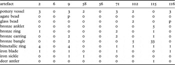
Thirty-one Iron Age 4 burials were recovered at Noen U-Loke, comprising seven males, three females, seven adults, two children and twelve infants. The spatial distribution reveals far less of the tight nucleation evident in the preceding phase (fig 17). However, there is some evidence for grouping, particularly in the case of six burials in the north-eastern part of the excavated area, where four people were superimposed over a depth of 0.68m. There are other examples of such superimpositions, while burials 4, 5, 9 and 12 might comprise a group, since all were interred at a similar depth and orientation. Phase 4 burials probably cover a reasonable period of time, since the lowest was found 1.77m below datum while the uppermost lay only 0.58m below datum. The orientation was similar to that seen in phase 3, and Phimai Black ceramics were still in use, but we lack the rice-bed burials, and the grave goods, while still abundant, did not reach the heights seen in Iron Age 3. Gold, silver, agate and glass continued to be worn as jewellery. There were also changes in the nature of the offerings, seen in both the style of the ceramics and the range and number of iron implements, that now included sickles (tables 5 and 6).
The layout of graves belonging to Noen U-Loke Iron Age 4

The mortuary offerings with relatively intact adult graves from Iron Age 4

M male; F female; A adult; YA young adult; O old; MA middle-aged adult; OA old adult; y year; p present
The mortuary offerings with relatively intact neonate graves from Iron Age 4

The thirty-five- to forty-year-old male in burial 1 was interred prone at a depth of 1.45m, and directly to the south of the infant jar burial 2. Grave goods incorporated fourteen bangles on the right hand and eight on the left (fig 18: B). He wore an ear coil on each ear (fig 18: C) and at least twenty-seven, and possibly thirty-three, rings on this right hand, including two on the thumb (fig 18: A). A further twenty-six rings were found on the left hand. Bimetallic rings continued to be favoured, two being located by the upper left leg and two more by the right shoulder.
Mortuary offerings from Iron Age 4 burials: A. burial 1, finger ring; B. burial 1, bangles; C. burial 1, ear coil; D. burial 12, toe ring; E. burial 102, glass beads; F. burial 116, glass beads; G. burial 73, iron knife; H. burial 5, agate pendant; I. burial 100, agate pendant; J. burial 73, agate pendant; K. burial 9, agate beads

Burial 5, a twenty- to twenty-five-year-old probable male, wore an agate pendant (fig 18: H) and necklace of agate beads. A bimetallic ring was also found in the neck area. Two iron implements lay by his left hand. One looks like a modern sickle, the other a tanged spearhead. The man in burial 61 lay prone, with the head pointing south. The grave goods were sparse: a bronze bangle on each arm, two bronze rings on a right-hand finger and a bronze earring. The most interesting aspect of this burial was the recovery of an iron arrowhead lodged in the man's spine. Its position indicated that it entered the body from in front and slightly below, and it was surely a fatal wound. Burial 68, a twenty-five- to thirty-year-old probable male, was accompanied by a bimetallic ring at the chest area, a bronze bangle and ring fragments in the area of the left hand and fifty-three gold beads in the vicinity of the neck, which were presumably a necklace.
The woman in burial 10 died when aged over forty. Several bronzes were recovered: six finger rings on the right and three on the left hand, three bangles on the right wrist, two earrings and an anklet on the right leg. An agate bead was found in the area of the neck, while an iron sickle and knife were found on the right upper arm. Burial 12, an older female, died when aged over forty years. Her grave goods included two fragmented pottery vessels over the left thigh and abdomen respectively and several bronze ornaments. These comprised a bangle on the right arm, an earring, three rings on the fingers of the left hand and toe rings, three on the left and five on the right foot. An iron knife blade and sickle were also recovered.
Burial 4 contained the remains of a fifteen- to eighteen-year-old. Grave goods comprised an agate pendant at the neck, a bronze bangle on each wrist and three bronze rings on the left hand. There were two pottery vessels in association, both positioned over the abdomen. An iron knife and iron sickle complete the list of offerings. Burial 8, a young adult, was accompanied by two pottery vessels placed over the chest and beyond the head, some glass beads in the area of the head, and an iron knife and sickle. Burial 59, a middle-aged adult, was interred with a bimetallic ring in the pubic area, a bronze bangle on each wrist and seven bronze finger rings, three on the right hand and four on the left. There was also an iron blade and a sickle, and four pottery vessels, two over the abdomen, one over the right femur and another at the left shoulder. A silver earring was recovered by the left ear.
Burial 67 contained a twenty- to twenty-six-year-old adult. The screening of the material from the vicinity of the skeleton yielded two glass beads, part of a bronze ring and a bangle fragment. The other grave goods found were a bronze earring and a bivalve shellfish. Burial 73 contained the skeleton of a thirty-five- to forty-year-old adult. Grave goods comprised three pottery vessels positioned beyond the head and an iron knife. There were also several bronze items of jewellery: nine toe rings on the right foot, six finger rings on the right hand and nine on the left and several ring fragments and four glass beads from the flotation process. There was also an agate neck pendant (fig 18: J).
The large mortuary jar of burial 2, that of a neonate, contained two pottery vessels and an iron knife blade. Jewellery comprised a bimetallic bangle on the right arm, two on the left arm, a loose bimetallic ring at the lip of the mortuary vessel and an earring. Burial 9 was a neonate interred within two mortuary jars. These had been placed mouth to mouth to contain the infant, at a depth of 0.69m below datum. A further pottery vessel was found within the two jars. The grave goods included an iron knife and sickle grouped to the left of the skeleton, which wore an agate bead necklace (fig 18: K), and bronze earrings. There were also two bronze bangles, one on each arm, and four bimetallic rings on the cranium. The neonates in burials 11 and 56 were found in mortuary vessels with no grave goods. Burial 58, a further neonate, was found within two mortuary vessels which faced each other. An iron sickle was found below these vessels and may have been in association as a grave good.
The skull of a probable neonate in burial 71 was found under three pottery vessels. Other offerings and the most likely placement were an iron knife to the left of the body, two bronze rings, two bronze earrings and a bimetallic ring in the head area. The jar of burial 102, a neonate, was found at the head of burial 96. It contained a second pottery vessel, as well as a necklace of glass beads, five bronze bangles and a bimetallic ring. Unusually, the neonate in burial 115 was not interred in a mortuary jar, but was laid out in the same manner as adults during this phase, with the head orientated to the north. The skeleton was found lying parallel with the shed antler of a medium-sized deer. Other grave goods comprised thirty-three bronze bangles, five bronze anklets, a bronze earring and a bimetallic ring in the area of the skull. A further bronze ring was present in the general area of the body. Burial 116, a neonate, was found with three pottery vessels, two over the head and one by the right ankle. The infant wore a glass-bead necklace (fig 18: E), and a bimetallic ring lay beside the head. An iron knife blade was found to the left of the skull and another iron object was recovered from the general area.
At Ban Non Wat, Iron Age 4 burials are found in a small opening towards the southern edge of the site, while the distinctive Phimai Black pots accompanied some scattered and rather disturbed graves in the main square, where one complete jar burial contained the remains of a newly born infant associated with miniature bronze bangles, glass beads and an agate pendant. One badly disturbed adult had worn gold, glass and carnelian beads and an agate pendant. The small area excavated at Non Muang Kao included eleven burials in at least two phases. While all were accompanied by Phimai Black pottery, only the later set included graves filled with rice and lined in clay.
Mortuary evidence: summary
There are only six burials in the IA 1 cemetery of Noen U-Loke. They reveal that iron was used for ornaments, weapons and heavy, socketed implements. Bronze was also cast into torcs and bangles as well as socketed spears. Fish and pig bones were placed with the dead. However, no burial contains glass or exotic hard stone ornaments. This might be due to the small sample size since, in a much larger sample in the initial IA 1 cemetery at Ban Non Wat, where there was a transition directly from the late Bronze Age, we do find glass ornaments and the occasional bead of agate and carnelian. The IA 1 cemetery of Ban Non Wat comprises inhumation graves that initially formed as a tightly nucleated group, in which there was much disturbance as burials were added. It is then suggested that the graves were added progressively to the east, and in two rows, with far less disturbance, as more intact graves were found here. In the northern row of graves, people were interred with the head to the north, but in the southern row, the head was directed to the south. As with the late Bronze Age, ceramic vessels remained similar in form and continued to be packed with fish. Some people were interred with spindle whorls and grey clay. But there were also changes, seen in the increase in bronze ornaments, bimetallic spears, iron spears and tool kits, lead castings, exotic stone ornaments and the bones of domesticated water buffalo. No individual or group within the cemetery stands out on the basis of mortuary wealth. We have not found any evidence for hierarchic social distinctions at Ban Non Wat in the early Iron Age.
The sequel is best seen at Noen U-Loke. Here, the second mortuary phase saw the tight nucleation of burials, each group containing the remains of men, women and young individuals. Glass, agate and carnelian made their appearance at this site, and in the later group, there were further changes. The dead were interred in graves filled with rice, bronze ornaments were more common and took on complex forms, and all but one of the carnelian beads were found here.
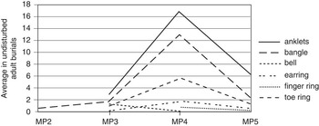
This trend towards nucleated groups and increased wealth continued into the third phase (fig 19). Four sets of burials were laid out on a chequer-board pattern. Again, they comprised men, women and young individuals, and it is suggested that they were related consanguinally and affinially. The mortuary rituals became more elaborate: some graves were lined and capped with clay and rice still covered the dead. Exotic grave offerings now included gold and silver. One of the most striking features of this phase is the proliferation of bronze ornaments, which now included ear-lobe inserts, belts and multiple toe and finger rings as well as rings made of iron and bronze. There are intriguing distinctions in the relative wealth of these nucleated groups. Group B is markedly the poorest, lacking gold, silver and multiple bronze ornaments but also containing many spindle whorls. The other three groups were much richer, each containing at least one outstandingly wealthy individual in addition to well-endowed burials of children and infants. The man in burial 14 of group D was associated with 244 offerings and an assemblage dominated by bronzes that included 150 bangles and three belts. Burial 69, another man, had 198 offerings, including four bronze belts. Burial 113, a woman not completely found within the excavated area, was interred with at least 159 items, including silver bangles and gold beads. This subset of wealthy individuals expressed their social standing through the ownership of a remarkable quantity of bronze ornaments as well as gold and silver jewellery.
The quantities of bronze mortuary offerings at Noen U-Loke

With the final phase, the tight nucleation of burials came to an end. Graves were widely distributed across the excavated area. Extreme wealth also fell away, although burial 1, a man, did wear a notable quantity of bronze ornaments. No more rice-filled graves were found. Iron grave goods now often included spears and sickles.
Occupation evidence
All sites contained the remains of clay floors. These survive most clearly at Non Muang Kao, where eight were found superimposed and virtually undisturbed, save for the cutting of graves through them. They had clearly formed straight edges and corners at right angles. Some were associated with ceramic vessels of the Phimai Black tradition, placed in pairs lip to lip. Revealing their complete extent and plans in this area of domestic settlement was ruled out by the exceptional hardness of the cultural deposits, which made excavation unusually slow.Footnote 34 At Noen U-Loke, the clay floors were mutilated by prehistoric disturbance. Several floors were traced at Ban Non Wat but again they were poorly preserved. However, at least two were found superimposed and associated with burnt timber foundations for a wall. It is often the case that fragments of burnt clay daub are recovered on or in the vicinity of these floors, and these reveal the impressions of a timber wattle framework that came from a wall that collapsed because of fire. A large quantity of burnt daub with the impressions of the wattle framework for a wall were recovered from Noen U-Loke.Footnote 35
At Noen U-Loke and Ban Non Wat, we encountered further floors without any clay structure to them, but littered with the bones of cattle, water buffalo, pig and the occasional deer. These floors also had iron artefacts, particularly knives, and large stones, which could have served as anvils. It is suggested that they were locations where mainly domestic animals were slaughtered and their limbs butchered. This could have been to fulfil domestic requirements, or it might equally have involved the provision of food for mortuary feasts. We also identified refuse pits containing the remains of animal bones, shellfish and collections of broken pottery vessels.
A survey of surface remains at Noen U-Loke identified a concentration of iron slag on the eastern edge of the site. Excavations there revealed a floor with smithing slag, suggesting that it was a location for forging iron artefacts. Similar slag fragments were found in the Iron Age layers at Ban Non Wat. Iron Age layers at both sites contained fragments of clay moulds for casting bronzes, and the crucibles used to contain the alloy during this procedure. At Ban Na Di, in the Sakhon Nakhon basin to the north, clay moulds for casting bangles using the lost-wax process were found. No similar moulds were found in any of the three sites under review, but bangles and anklets cast with lost wax were present in some graves. The offerings placed with the dead also contained spindle whorls and deposits of grey clay. It is evident that the production of yarn was undertaken, while the clay, which may be used a fabric dye, together with the pseudomorphic remains of cloth, suggest that weaving also took place. Marine shell was imported to Ban Non Wat and converted there into bangles.
There are two small and steep-sided mounds to the west of Noen U-Loke which are littered with large, coarse ceramic sherds. Neither has been excavated, but similar mounds have been examined and these contain evidence for the production of salt during the Iron Age through a procedure still practised in north-east Thailand.
The construction of the banks and moats
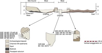
The banks and moats round the Iron Age settlements of the Mun Valley have for long been an enigma. They are so extensive (those of Noen U-Loke covering 200m from the mound's edge) that excavating them presents an unusual challenge, not least because, even in the dry season, the water table is so high that trenches rapidly fill. We therefore decided to open trenches with a mechanical digger radially outwards from the mound's edge at Noen U-Loke, Ban Non Wat, Non Muang Kao, Ban Non Khrua Chut and Ban Makham Thae.Footnote 36 Prior to the excavation of these trenches, the profile of the moats was unknown. The analysis of the sections soon revealed that the banks were constructed from soil removed from the ground surface; the space between these banks was flat and in due course infilled with sediments brought in by the stream or river that fed into them (fig 20). Two approaches were taken to date these water-engineering works. The first involved AMS radiocarbon determinations on the charcoal within the moat infill; the second was to date charcoal from in situ features identified within the banks. As with all unspeciated charcoal dates, each is interpreted as likely to be a terminus post quem for the event being dated. For Noen U-Loke, two AMS dates from a channel buried below the edge of the mound are 81–339 cal ad and 87 bc–114 cal ad. The other two determinations come from carbonized rice grains found in a channel below the first moat, and are 405–600 cal ad and 543–798 cal ad, respectively.
A schematic cross-section through the moats of Ban Non Wat. The radiocarbon determinations are from shell, and expressed at calibrated 2 sigma

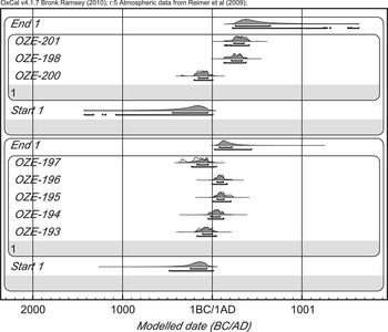
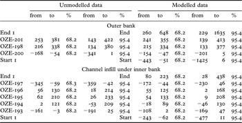
Two banks are visible today at Ban Non Wat. Seven AMS dates were obtained from charcoal retrieved from the innermost (fig 21; table 7). They indicate that construction and use took place within the first to the fifth centuries ad. Ban Non Khrua Chut has not been excavated, save for the sections through the moats. It lies 9km to the west of Noen U-Loke and is surrounded by two banks and moats. Two AMS dates of 384–621 cal ad and 254–416 cal ad come from a channel beneath the mound edge. A buried channel beneath the first bank returned a date of 362–617 cal ad. A channel between the two banks is dated 254–427 cal ad and 356–535 cal ad, while the outer bank has provided five similar determinations with a minimum and a maximum range of 263–559 cal ad. Ban Makham Thae has two moats, and at least two channels, now covered by Iron Age occupation deposits. A determination from one of the former channels is 32–336 cal ad. Three dates from a channel under the innermost bank are 231–531 cal ad and 422–642 cal ad, while one further sample from moat infill is 341–641 cal ad.
The modelled radiocarbon determinations for the construction of the moats and banks at Ban Non Wat. Above: the samples from the outer bank; below: from channel infill

The radiocarbon determinations from the moats and banks of Ban Non Wat, before and after being modelled with OxCal. 4.0

These determinations combine to indicate that bank construction and the active infilling of the sediments within the moats belong to the later Iron Age occupation. It seems most likely that the settlements in question were ringed by these water-control measures during IA 3 and 4.
Synthesis and conclusions
The Mun Valley contains a considerable number of large, moated prehistoric sites. In the study area, these are found in close proximity. Only 2km separate Noen U-Loke and Ban Non Wat. By integrating the cultural sequences from the three sites that have been excavated, it is possible, for the first time in south-east Asia, to trace the complete sequence of the Iron Age. In the case of Ban Non Wat, it is also possible to review the early Iron Age in the context of the preceding six phases of the Bronze Age.
The seventy-six radiocarbon determinations from Ban Non Wat reveal that the transition from the late Bronze into the early Iron Age took place in the second half of the fifth century bc.Footnote 37 A similar date has been suggested by the earlier set of radiocarbon determinations from Noen U-Loke. The importance of the horizontal stratigraphy that characterizes the transition into the Iron Age in the Ban Non Wat cemetery lies in the fact that it illuminates the cultural changes that took place as iron working was introduced. We find that there was no evidence for sudden or dramatic change in the mortuary rituals as there had been with the advent of the Bronze Age at this site six centuries previously, when men, women, infants and children were interred with a remarkable quantity of exotic offerings. It has been suggested that this reflects the activities of aggrandizers who sought, through mortuary feasting, to advertise their social standing and ability to control the sources and ownership of such exotic valuables as copper, marine shell and marble. By Bronze Ages 4 and 5, the wealth of all but a few individuals declined dramatically, and copper-based offerings almost disappeared. The last phase of the Bronze Age cemetery saw individuals interred with a handful of ceramic vessels, some containing fish, and a mix of spindle whorls, grey clay, red ochre, pig's limb bones, bivalve shells and, very occasionally, cattle bones, shell beads and shell bangles.
To this background, we find that while the basic ritual orientation of the graves and mortuary goods continued into Iron Age 1, there was a new range of offerings. These included iron weaponry, tools and ornaments, together with rare ornaments of glass, agate and carnelian. There were more bronzes than during the later Bronze Age, with demanding lost-wax castings of bangles and anklets and bronze sockets to iron-bladed spears. The practice of placing complete fish in pottery vessels continued, and there are also the limb bones of domesticated water buffalo and cattle. Pig limbs were encountered often, and in two cases an entire pig had been placed with the deceased. It is not possible to relate this large mortuary assemblage with the earliest Iron Age burials at Noen U-Loke, where only a handful of graves were uncovered, none having glass, carnelian or agate ornaments. However, they did include iron ornaments and spears, bronze bangles and neck rings, similar pots, fish and pig limbs. The regular incorporation of fish and pig remains suggests that, as with the Bronze Age ancestors, the provision of mortuary feasts was an important social act. Such feasting, which continues in south-east Asia to this day, is a means whereby a social group can gain in status and prestige through the degree to which they can display their command over resources and engage in conspicuous consumption.Footnote 38
The course of events following the early expression of the Iron Age at Ban Non Wat are best traced at Noen U-Loke. In the second phase there, we encounter the first glass, agate and carnelian ornaments and a proliferation of complex bronze castings. The interment of the dead in a grave filled with burnt rice was a major change in the rituals of death. The remarkable abundance of the rice in these graves, albeit in conjunction with fewer animal-bone offerings, again stresses the relevance of mortuary feasting. Even a newly born infant was found covered in rice within a mortuary vessel. This rise in the complexity of burials and the range of offerings reached its climax in the following phase, when the graves were not only filled with rice but also lined and capped with clay. The quantity of bronze ornaments is unprecedented, before or after and at this or any other known site in the region. One man was interred with 150 bronze bangles, three belts with sophisticated clasps, sixty-one finger rings, some with spiral embellishments, and four toe rings. He also wore ear-lobe inserts of silver and gold. This surge in ornamental bronzes harmonizes with the contemporary rise of output in the main production centres in the Khao Wong Prachan valley and the recently identified Iron Age copper mining complex at Sepon in Laos. It was also during phases 3 and 4 that the moats and banks were constructed. The rise of elite individuals, as represented by the outstandingly rich men and women of Iron Age 3, dovetails neatly with the social organization of labour that would have been involved in the construction of these water-control measures. There can be little doubt that this was a most important phase in the development of social complexity. As is well known, the Angkorian kingdom was very much dependent on the control of water, both symbolically, as a projection of royal divinity, and economically, to bring water to the rice fields. We can trace the very genesis of this in the Iron Age moats of the Mun Valley. To have a settlement ringed by five water-filled moats in the dry season would not simply have provided water for a growing population; it would also have ensured a ready supply of fish and, possibly, rice; and, in a time of increasing competition, it would have provided a measure of defence. The more impressive the complex of moats, the greater the social status of those who devised and controlled it.
The final mortuary phase is represented at all three sites. We find rich infants interred in lidded ceramic vessels, the presence of iron sickles, a rise in the number of iron points and, in one case, a young man who had been killed when an iron arrow severed his spine. Although the quantity of exotic ornaments declined from its previous peaks, there remained an impressive quantity of bronzes, glass and agate beads and pendants.
In the later Iron Age, these moated sites clearly harboured individuals of considerable wealth and status. They were also centres for the production of cloth, iron tools, the casting of bronzes and the manufacture of high-quality Phimai Black pottery vessels. The many small mounds that surround the moated centres evidence the production of salt. The moats themselves could have been multi-purpose. Boyd has suggested that the later Iron Age was a period of increasing dryness.Footnote 39 The sites were preferentially located next to stream channels, and the construction of banks permitted water to be controlled and retained in the immediate environs of each settlement. The presence of iron weaponry leaves little doubt that conflict was on the rise, although the evidence is not as clear-cut as for the contemporary site of Phum Snay, in northern Cambodia, where the many skeletons discarded by looters bear the scars of fighting.Footnote 40
Appreciating the deep-seated cultural changes that took place with the advent of the Iron Age in the Mun Valley and, on a wider focus, in south-east Asia as a whole, can be more intimately appreciated by referring to cases in the more recent past, where new exchange contacts were established. Brenner, for example, has described the impact of seventeenth-century European settlement in New England on the native Americans.Footnote 41 Essentially, the presence of exotic new settlers presented the indigenous peoples with opportunities to acquire a new range of prestige goods, to develop new trading relations, gain access to new forms of weaponry and engage in new forms of economic activity. Traditionally, ownership of wampum, sacred white shell beads, was used to project wealth and status. To this could now be added beads of glass, iron weaponry, brass ornaments, European clothing and many other novel and desirable objects. These combined to create stress and instability as the new opportunities were sought by leaders as they competed for elevated status, authority and power. We encounter, in their burial grounds, clear evidence for the deployment of the new status symbols in the rituals of death. Thus, the successful new aggrandizers were interred with large quantities of shell and glass beads, ornamental rings, iron weapons and even boxes to contain trinkets and desirable objects such as keys.
Such changes have been seen in other instances of new cultural contacts. Alpers, for example, noted how coastal trade stimulated the rise of powerful male leaders in Malawi.Footnote 42 Again, it was the control of access to coastal trade that allowed ambitious inland men to rise rapidly in wealth and power through their ownership of exotic valuables and ability, through distributing some of these, to attract supporters and followers. Ekholm has echoed these developments in the context of central Africa. Here, we find that, in her words, ‘power relations are established, consolidated and maintained through the control of prestige articles’, which included salt, copper and shells.Footnote 43
It is therefore possible to integrate a series of factors in the Mun Valley that would have encouraged a sharp rise in social complexity, as well as increasing stress caused by competition. These include the introduction of a new range of desirable but exotic valuables, control of which would have conferred increased social standing: gold, silver, iron, carnelian, glass and agate. There was the potential to concentrate wealth through the production and exchange of salt, rice, domesticated water buffaloes, pigs, cloth and fine ceramics. Competition over valued or scarce resources can be inferred from their selective presence in elite graves. The concentration of sites in the best agricultural land and strategic riverine trade routes likewise would have fostered competition, and increasing conflict would have encouraged investment in leadership. An effervescent mix of stimuli thus combined to encourage social change: we can identify population growth, the introduction of new and exotic goods into exchange circuits, the surge in copper production, the potential of cornering and controlling the deployment of salt, military competition and increased agricultural production.
However, the final phase saw a marked decline in the wealth placed with the dead, and an end to the tight nucleation of graves in what were surely kin groups. Talbot has suggested that, by this period, social stress and competition within this settlement might have subsided and, with it, the need to advertise status so overtly.Footnote 44 This possibility must be considered relative to the chronological span of ad 400–600 for IA 4, for this was the period within which early states were forming in the Mun River Valley. It thus becomes possible to consult written records in the form of inscriptions carved in Sanskrit, Mon and old Khmer languages. One of these, from Wat Phu, just south of the confluence of the Mun and Mekong rivers, records the erection, in the late fifth century ad, of an inscription by one Devanika, a fine Sanskrit name for a man described as a maharajadhiraja, supreme king of kings.Footnote 45 It recorded how this magnate, having won innumerable victories, came from afar to found a kingdom and offered rich tributes to his temple foundation. This was clearly a period of major social change involving the rapid transition into early statelets. We find that many moated sites, including Noen U-Loke, were abandoned by the sixth and seventh centuries ad, just as new regal centres, such as Phimai, Muang Sema and Wat Phu, were being founded.
The Chenla statelets
The period between ad 550 and 800 is known as Chenla, after the Chinese texts that describe visits to south-east Asia and tribute missions sent from this region to China. The period is illuminated by an important corpus of inscriptions. Vickery's review of these allows a direct line of development to be identified, linking the late Iron Age with the early historic period.Footnote 46 He has identified the social importance of men known as pon in the developing Chenla statelets. These community leaders were closely involved in the development of valued facilities, such as water control, the construction of ponds and roads and the maintenance of temples. They inherited their status positions through the female line, a situation that allows us to understand more fully the wealth and social persona of late Iron Age women.
In evaluating the early historic period in the Mun Valley itself, we can turn to a concentration of inscriptions carved sometimes in Mon or Khmer, and on occasion with Sanskrit texts, in Nakhon Ratchasima and Chaiyaphum provinces which stylistically belong in the seventh to the ninth centuries ad. These must be considered in relation to the excavations at Muang Sema.Footnote 47 This is a critical large site covering an area of 755 by 1845m, which reveals, through its two moated enclosures, a considerable expansion in size. Excavations showed that occupation began with a 3m-thick deposit in which the ceramics, such as the carinated and incised bowls, reveal close similarities with sites of the Dvaravati states in central Thailand. This was followed by a 0.40m thick layer in which Khmer material appeared, to be followed in the uppermost 1.1m by Khmer ceramics dating from the tenth century onwards. The initial Dvaravati occupation provides strong evidence, in the form of bronze Buddha images, a part of a wheel of the law, stone statues of deer and tablets of Boddhisatvas, that Buddhism was the dominant religion at this site. It is also to this period that an enormous reclining Buddha, the largest in Thailand, belongs.
The Bor E-ka is a tenth-century temple sanctuary located in the middle of the moated enclosure. An inscription, stylistically belonging to the ninth century, in Sanskrit and Khmer, records the gift by the overlord of a polity named Sri Canasa of twenty fat and healthy water-buffalo cows, fifty cows with full udders and healthy calves, and ten male and female slaves to a Buddhist community, in order to gain merit. An inscription of ad 937 found at Ayutthaya records that a Mangalavarman ruled over Sri Canasa. Hanwong has suggested that at this period, Muang Sema was the centre of the polity of Sri Canasa.Footnote 48 Saraya, however, has preferred Sri Thep as the capital.Footnote 49 Perhaps only the discovery of more inscriptions will resolve issues such as this but, in either case, Muang Sema illustrates the size and scale of early Dvaravati centres in the Mun Valley before strong influence from Angkor manifested itself. Again, more extensive excavations, preferably in the older of the two moated areas at Muang Sema, may well reveal prehistoric origins to the settlement.
There is a small corpus of other inscriptions that tell the same story, of local rulers with Sanskrit names ruling over groups who probably spoke Khmer. At Hin Khon, 35km south of Nakhon Ratchasima, an overlord called Nripendradhipativarman, who ruled in a city called Sro Vraah, erected four sema stones, the markers of sacred space, during the eighth century and made the meritorious gift of rice fields, slaves, flowers, fruit, cattle, gold and silver utensils, an elephant and betel trees to a Buddhist temple.Footnote 50 Two further inscriptions also record the names of rulers – Indravarman, Soryavarman and Jayasinhavarman – and a capital called Tamran. Further to the east, there is an inscription from Wat Ban Song Puay in Yasothon which mentions a King Pravarasena and his capital Sankhapura. We can agree with Jacques that these seventh- and eighth-century polities find their roots in the large Iron Age moated settlements that so dominate the archaeological landscape of the Mun Valley.Footnote 51
Acknowledgements
The research described in this paper was made possible by permits granted by the National Research Council of Thailand and the Thai Fine Arts Department. The fieldwork has been financed by the Marsden Fund, Earthwatch and its Research Corps and Uniforce Sales and Engineering.
I wish to thank my co-directors, Rachanie Thosarat and Amphan Kijngam, and the many colleagues who have contributed their expertise to the excavations and the analyses of finds. Nancy Tayles, Sian Halcrow and Kate Domett studied the human remains. William Boyd directed the palaeoenvironmental research and is thanked for Figures 4 and 20. Thomas Higham has undertaken all the radiocarbon dating and provided Figures 5 and 21 and Tables 1 and 7. Sarah Talbot is thanked for her contribution both in the excavation of Neon U-Loke and for Figure 19. Finally, I thank this Journal's two anonymous referees for their valuable comments.