Introduction
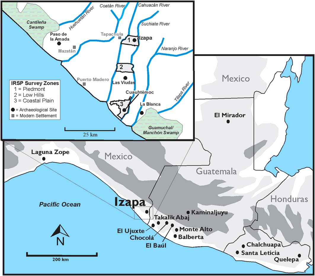
As one of a handful of locations in the world where cities were independently established, Mesoamerica provides important comparative examples for the origins of urban life (Cowgill Reference Cowgill2004). Izapa is the largest and best-known pre-Hispanic city in the lowland Pacific region of southern Mesoamerica (Figure 1). Until now, however, the political organisation and territorial extent of the city’s associated polity were completely unknown. The newly acquired lidar (light detection and ranging) and pedestrian survey data presented here demonstrate that, by 700 BC, Izapa was the capital of an integrated kingdom comprising dozens of lower-order monumental centres.
Monumental centres in the Southern City-State Culture and Izapa Regional Settlement Project (IRSP) survey zones (inset).

The first research projects to contextualise early Mesoamerican cities within regional settlement patterns were undertaken in the Mexican highlands (Sanders et al. Reference Sanders, Parsons and Santley1979; Kowalewski Reference Kowalewski1989). Due to arid conditions and extensive erosion in these regions, evidence for pre-Hispanic occupation is generally visible on the ground’s surface. In contrast, settlements in Mesoamerica’s lowlands are concealed by tropical forest, making it difficult to rely on pedestrian surveys alone. In this context, lidar has emerged as a transformative tool for documenting archaeological settlements, and is particularly useful in tropical lowlands (e.g. Chase et al. Reference Chase, Chase, Fisher, Leisz and Weishampel2012). The nature of lowland Mesoamerican polities also differed from their highland neighbours, and demonstrates more similarity with low-density urban centres in other tropical regions of the world (Isendalh & Smith Reference Isendahl and Smith2013; Hutson Reference Hutson2016).
Izapa’s impressive architecture and carved monuments have led to speculation about the nature of the power of the site’s elite. Based on early work undertaken by the New World Archaeological Foundation (NWAF), Lowe et al. (Reference Lowe, Lee and Espinoza1982: 307) described Izapa as “a major regional community center […that…] provided commercial and service functions as well as religious needs of a fairly large, relatively concentrated, group of people”. More recently, Love (2007, 2011) and Demarest (Reference Demarest2004: 67) proposed that Izapa and the other large sites along the coast of Guatemala were urban political and economic centres during the Late Formative period. There has, however, been no regional data from around Izapa with which to evaluate these interpretations. In fact, until the initiation of the Izapa Regional Settlement Project (IRSP) in 2011, there was no evidence for Izapa’s regional organisation.
Here, we present lidar and pedestrian survey data that document first-millennium BC settlement patterns in the Izapa region. By 700 BC—a century after Izapa was founded—over three dozen monumental centres were constructed, using the same architectural arrangement and site orientation. This coordinated consistency of mound centres indicates a shared political ideology and organised programme of public works. The Izapa kingdom covered around 450km2, with the largest centres defensively arranged around the polity’s perimeter. Lidar and pedestrian survey data now combine to make Izapa one of the most completely documented early polities of lowland Mesoamerica.
The Izapa region of southern Mexico
Izapa is renowned for its mounds measuring up to 20m in height and for its plazas filled with elaborately carved stone monuments depicting mythological and political narrative scenes (Figure 2; Guernsey Reference Guernsey2006). Stelae carved in the so-called ‘Izapa-style’ are also known, albeit in smaller quantities, from other cities in the region (Lowe et al. Reference Lowe, Lee and Espinoza1982: 17–18; Inomata & Henderson Reference Inomata and Henderson2016). Once posited as the link between the Olmec and Maya art styles (Coe Reference Coe1962), public art at Izapa is now understood as one example among many kingdoms that emerged during the first millennium BC (Clark Reference Clark2016). The network of early polities on the Pacific coast and nearby highland valleys has been referred to as Mesoamerica’s ‘Southern City-State Culture’ (Hansen Reference Hansen2000; Love 2011: 48), which shared an elite culture of personal customs, public rituals and religious beliefs that reflected social stratification and political hierarchy. As with other peer polities (Renfrew Reference Renfrew1986), each of those that emerged in Pacific Mesoamerica during the Formative period were politically independent but linked economically and socially through trade, ritual and warfare.
Izapa’s stela 21 inset (courtesy of the New World Archaeological Foundation).

The site of Izapa is located on the piedmont of the Sierra Madre Mountains (170m asl). The local environment is tropical, with annual rainfall of 3600mm. Located below the piedmont is a zone of low hills, followed by a coastal plain and then a mangrove estuary (Lowe et al. Reference Lowe, Lee and Espinoza1982: 55–62; Figure 1). Prior to the establishment of Izapa, occupation in the Soconusco region was confined predominantly to the coastal plain. Early villagers occupied ecotones between estuaries and rich alluvial soils, and by 1700 BC, incipient chiefs are documented in the Mazatán area. Interaction with the Gulf Coast Olmec resulted in the abandonment of the Mazatán polities and the establishment of new centres adjacent to the nearby Coatán River (Clark & Pye Reference Clark and Pye2011). The increasing reliance on maize after 1000 BC (Rosenswig et al. Reference Rosenswig, VanDerwarker, Culleton and Kennett2015a) corresponds with a total abandonment of the Mazatán area and population re-aggregation around the new political centre of La Blanca (Love Reference Love2002; Rosenswig 2010). The prominence of this first Mesoamerican proto-urban site was short-lived, and the polity was eclipsed by Izapa.
Excavations at Izapa were first undertaken by Philip Drucker (Reference Drucker1948). The site’s architecture and sculpture were documented more thoroughly in the 1960s by the NWAF (Lowe et al. Reference Lowe, Lee and Espinoza1982, Reference Lowe, Ekholm and Clark2013). NWAF research focused on Izapa’s urban core, which reached its apogee during the Guillén phase, 300–100 BC (Lowe et al. Reference Lowe, Lee and Espinoza1982: 133). Little was documented beyond the large mounds and carved monuments that formed Izapa’s urban core.
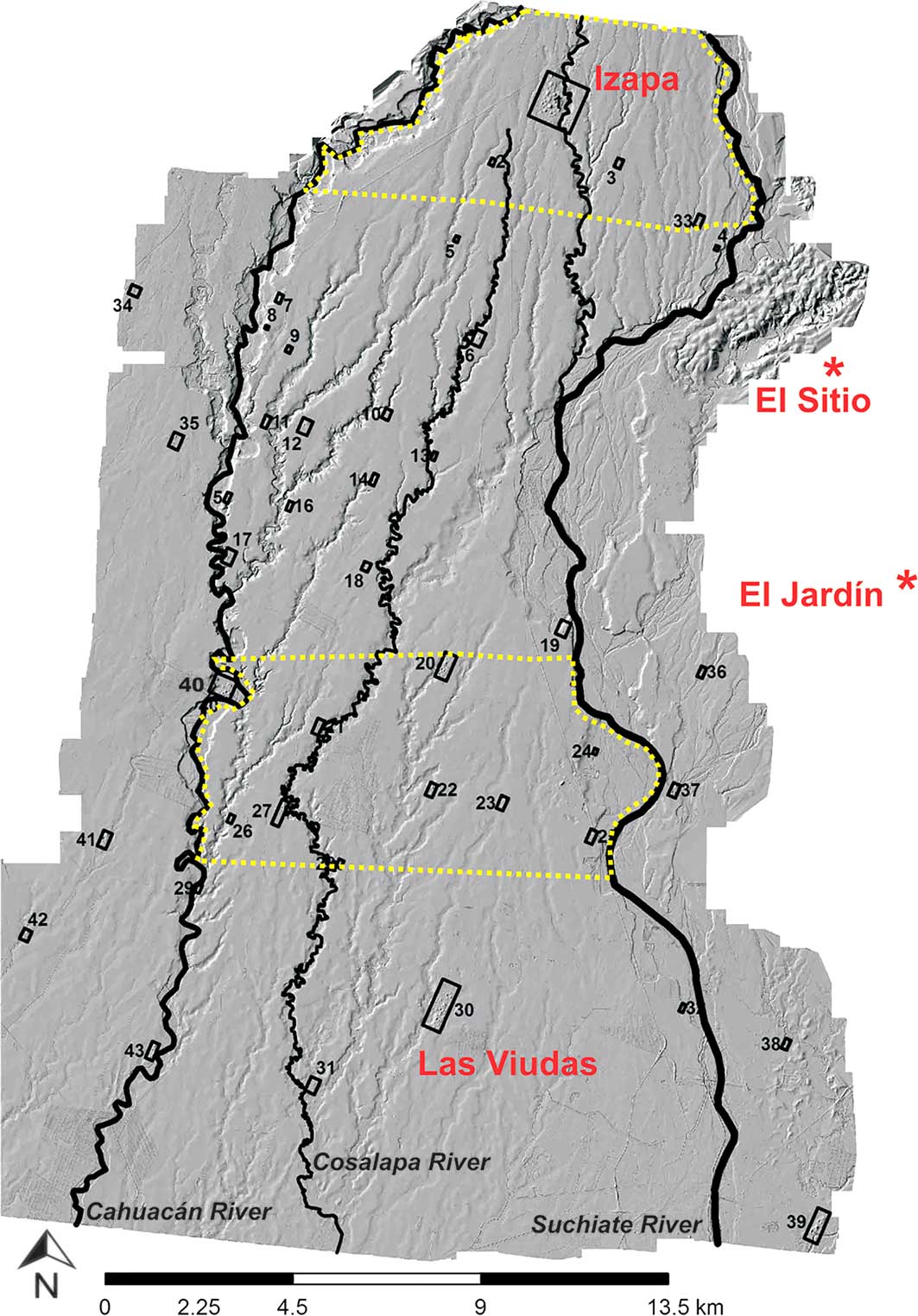
Between 2011 and 2015, the IRSP employed pedestrian survey and two lidar campaigns to document regional settlement patterns around Izapa in an area that now encompasses 584.8km2 (see the online supplementary material (OSM): S1–11). The first lidar campaign covered both 57.8km2 from a piedmont survey zone (Rosenswig et al. Reference Rosenswig, López-Torrijos, Antonelli and Mendelsohn2013) and 87km2 from a low hills zone (Rosenswig et al. Reference Rosenswig, López-Torrijos and Antonelli2015b) that together identified over 1000 pre-Hispanic mounds. While some smaller mounds were probably missed, we are confident that all architectural features above 0.5m in height were detected. All mounds in both survey zones were visited and the age of occupation determined by the analysis of surface artefacts. The second campaign of lidar data acquisition increased the total area of coverage, joining the initial piedmont and low hills survey zones (Figure 3). Ground-truthing within this larger area prioritised Formative-period mound centres, which we determined were all occupied during the six centuries that comprised the Escalón, Frontera and Guillén phases (700–100 BC).
IRSP lidar collection area with the location of Formative-period monumental centres indicated by site number. Dotted lines indicate the initial lidar collection zones for the piedmont and low hills.

While there are problems inherent with dating sites from surface remains, stratigraphic data and radiocarbon dating at two excavated centres in the kingdom demonstrate clear correspondence between surface remains and the occupation of each site (see OSM: S11, 23–25). As a lack of surface evidence, however, does not mean a lack of occupation, the results should be understood to represent a minimum number of mounds and the minimum number of occupation phases. Sites were probably occupied for more time and covered larger areas than reported here. Despite such methodological caveats, an important new substantive pattern is that the Izapa kingdom was established as a regional polity during the Escalón phase, a century after the first mounds were built at the site of Izapa during the previous Duende phase (800–700 BC).
Consistency of urban form
Urbanism is defined here in a formal sense, in which human labour is marshalled for political, religious and administrative functions (Smith Reference Smith2007, Reference Smith2011). Monumental architecture at each Izapa-kingdom centre is assumed to reflect (among other things), routinised ceremonial and ritual behaviour sponsored by the elites, in order to naturalise their elevated social standing, political power and economic privilege (Smith Reference Smith2014; Murphy Reference Murphy2016). It is further inferred that the similarity of such behaviour at each centre (as reflected by shared architectural features) contributes to a shared identity within the polity. The orientation and site layout of all Izapa-kingdom centres demonstrates coordination in urban planning, reflected particularly in the monumental features and plazas (Smith Reference Smith2007: 8–10).
Lidar data allow us to document site orientation and urban organisation across the entire Izapa kingdom with a high degree of precision. Forty-one monumental centres are now documented with lidar. Thirty-seven of the centres are in Mexico (Table S2; Figures S5–42), and four others were documented on the Guatemalan side of the border (Figures S43–48). All centres within the kingdom are laid out within a narrow range (18–28° east of north), orienting them between the Tacaná and Tajumulco volcanoes. These two volcanoes are the most prominent natural features on the local landscape, rising dramatically from the Sierra Madre.
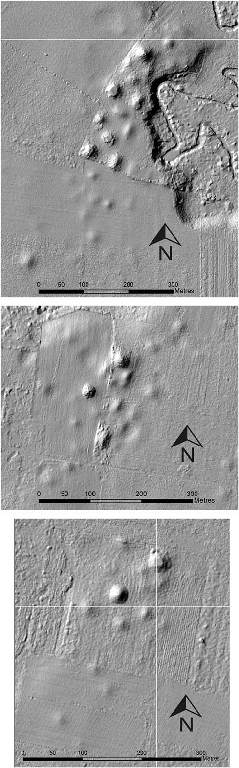
All Izapa-kingdom centres also share the same architectural components and arrays of public buildings. Each centre has a large, conical pyramid mound at its northern end that, at all but the smallest centres, sits on a platform (Figure 4). The northern mound and south side of the platform create a ‘stage’ that faces south towards the rest of each site’s monumental architecture. At most centres, three architectural features—possibly shrines—are discernible on the platforms’ southern edges. These ‘stages’ are visible from all the other mounds built to the south at each centre. As a result, the Tacaná and Tajumulco volcanoes provide a backdrop to the northern pyramid mound when viewed from any of the mounds or plazas to the south, embedding ritual and performance space within both cultural and natural geography. That this arrangement was repeated at all known Izapa-kingdom centres indicates kingdom-wide rituals physically structured by the built environment that defined the daily lives of each site’s residents (Smith Reference Smith2014: 311–12) and reinforced the political and social hierarchy through cosmological association.
Three sites that exemplify the architectural patterns of the Izapa kingdom: sites 27 (top), 22 (middle) and 23 (bottom).

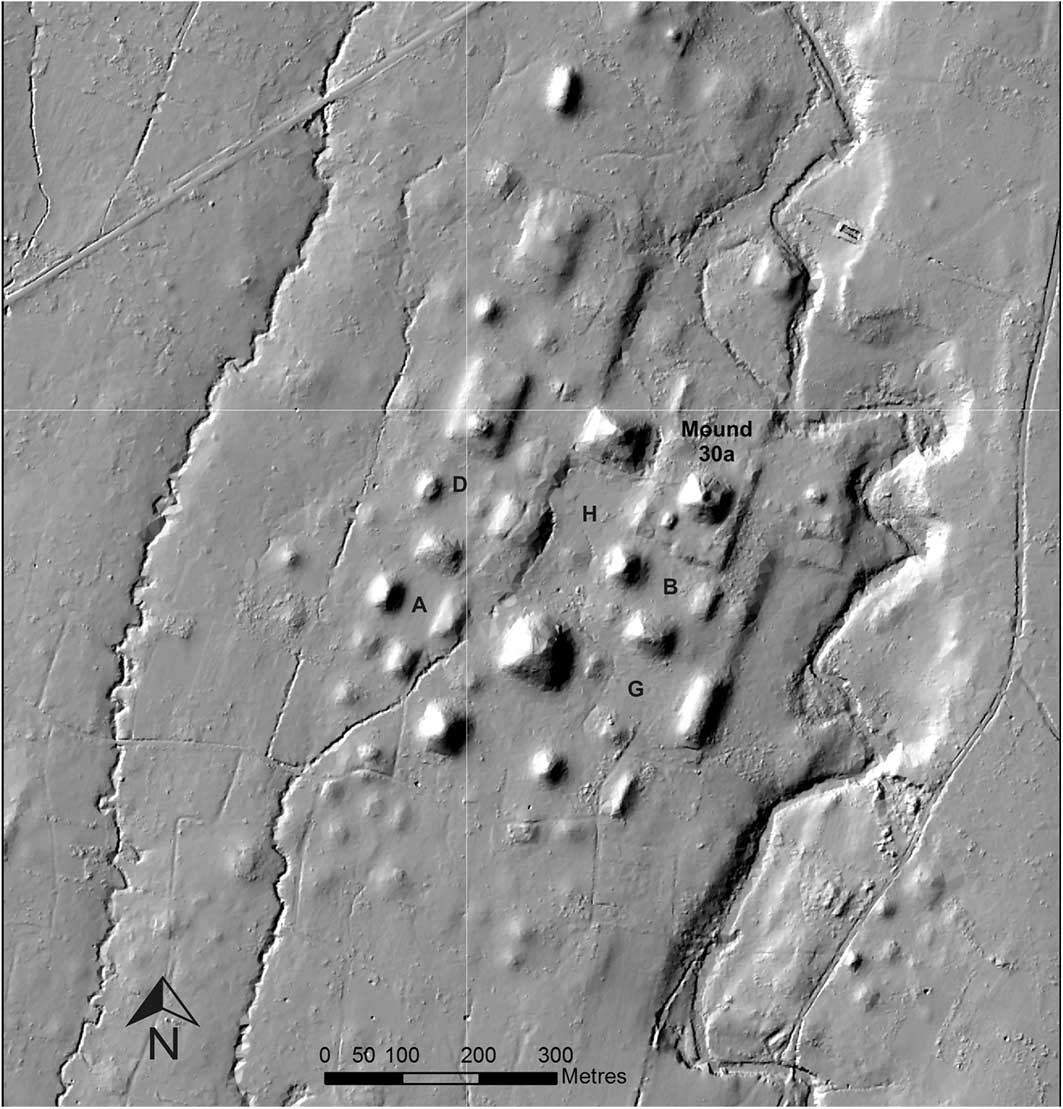
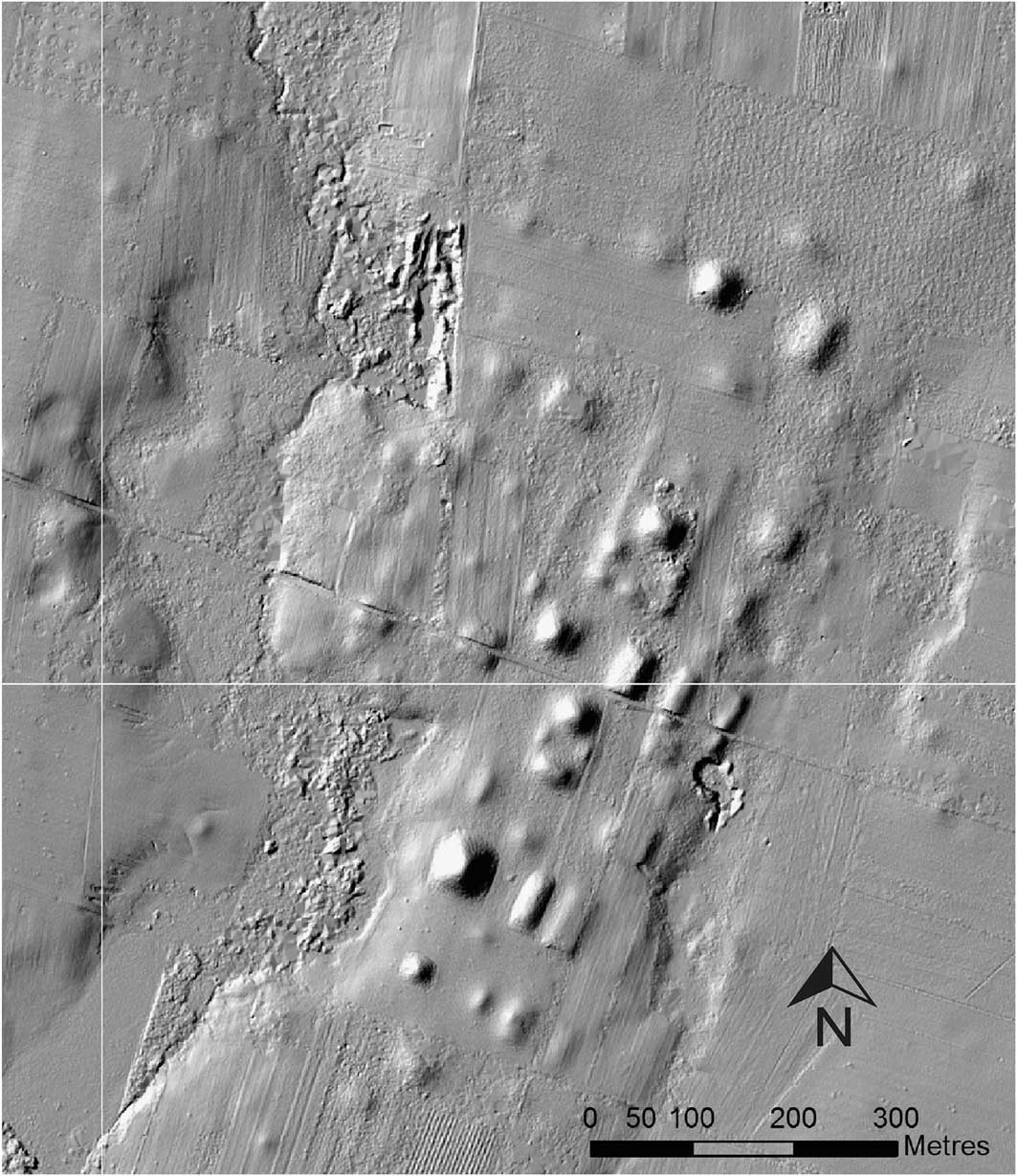
At each of the Izapa kingdom’s monumental centres, one to four plazas were formed by mound groups that extended south of the northern pyramid. The arrangement of the Izapa polity centres beginning at 700 BC is consistent with what Clark and Hansen (Reference Clark and Hansen2001) call the ‘Middle Formative Chiapas’ (MFC) pattern. Although the Izapa capital (Figure 5) was originally laid out in the same manner as the smaller centres, the site was expanded to the west during the Late Formative period Guillén phase (300–100 BC). Mound 30a was first constructed to a height of 12m during the Duende phase (800–700 BC), before a platform was built up around the original mound and the pyramid augmented during the following Escalón phase. The mound was expanded again during the Frontera and Guillén phases to its current height of 18m (Lowe et al. Reference Lowe, Lee and Espinoza1982: 133). Mound 30a was therefore Izapa’s main pyramid, originally built at the north end of the site, with three plazas (groups B and two components of group G) laid out to its south (Figure 5).
Hillshaded DEM of the Izapa capital (site 1); the letters indicate plaza groups.

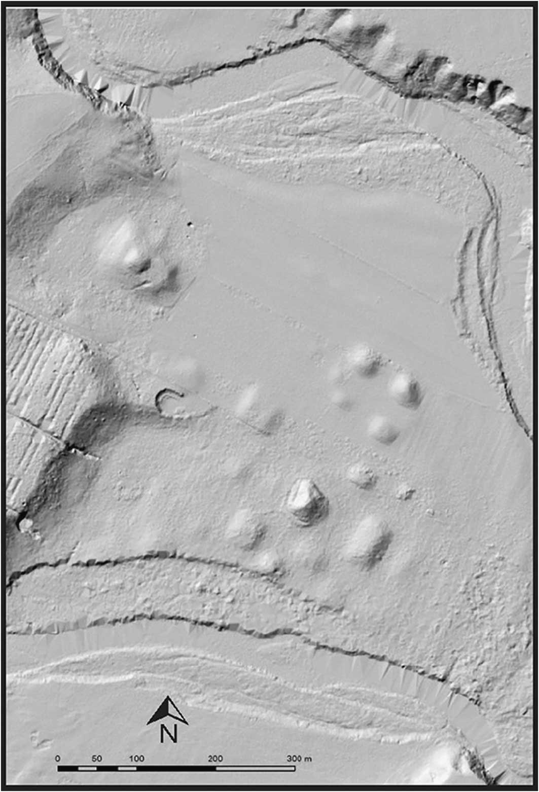
To be clear, the site of Izapa does not currently conform to what we term the ‘Izapa pattern’, as the capital was expanded repeatedly during its occupation. Excavation at Izapa, however, has shown that this layout characterised the site during the Escalón and Frontera phases (700–300 BC) (Lowe et al. Reference Lowe, Lee and Espinoza1982, Reference Lowe, Ekholm and Clark2013; Rosenswig et al. in press). During the subsequent Guillén phase (300–100 BC), plaza groups A and H were built to the west of groups B and G. More mounds were later built to form group D, and the northern side of mound 30a’s platform was augmented significantly during Terminal Formative times (Rosenswig & Mendelsohn Reference Rosenswig and Mendelsohn2016). Our current understanding of Izapa’s monumental architecture is the result of considerable expansion from the original Middle Formative plan. Every centre that comprised the Izapa kingdom, including the three small centres shown in Figure 4 as well as Las Viudas (Figure 6)—the second largest city in the kingdom—were all constructed in this way as a series of plazas extending north–south (see Figures S5–48).
Hillshaded DEM of Las Viudas (site 30), the largest secondary centre in the kingdom.

Within the early pan-Mesoamerican tradition of kings and elite culture—of which the Pacific coast polities were a part—individual practices differentiated independent polities. Similarity in architectural arrangement and site orientation within the Izapa realm is contrasted with different architectural patterns among Pacific neighbours, such as the kingdoms of El Ujuxte and Takalik Abaj (Figure 1), which imply different ritual practices and cultural affiliations (Love 2011: 54–61). Cities in the El Ujuxte kingdom, for example, are oriented 35° east of north. Although mounds were built to form plazas, they were not all aligned in a single row, as at the Izapa-kingdom centres. El Ujuxte polity centres have a platform on which a large conical mound sits, but with seven, rather than three, associated architectural features on the ‘stage’. Takalik Abaj is the only kingdom on Mesoamerica’s Pacific coast with quantities of stone monuments comparable to Izapa (Love 2007: 293–94). Unlike Izapa and El Ujuxte, however, the monumental architecture at Takalik Abaj’s Formative-period centre was focused on the two large terraces of the central group, where the majority of sculptures were erected (Schrieber de Lavarreda & Orrego Corzo Reference Schrieber de Lavarreda and Corzo2010: 180–87). This layout indicates that a third distinct architectural tradition was employed by this nearby Pacific kingdom. These three neighbours (and other early polities across Mesoamerica) shared a common set of organising principles for urban structure and elite culture (Doyle Reference Doyle2012: 369), yet differences in detail defined each kingdom as a separate political entity (Love 2011). As with medieval European kingdoms, each had their own language and traditions, but all shared political symbols (i.e. thrones, crowns) and architecture that naturalised political authority such as throne rooms and churches. In the medieval analogy, different details in architectural design for Catholic, Protestant or Eastern Orthodox churches all provided similar divine justification for their respective kings’ right to rule.
Regional hierarchy
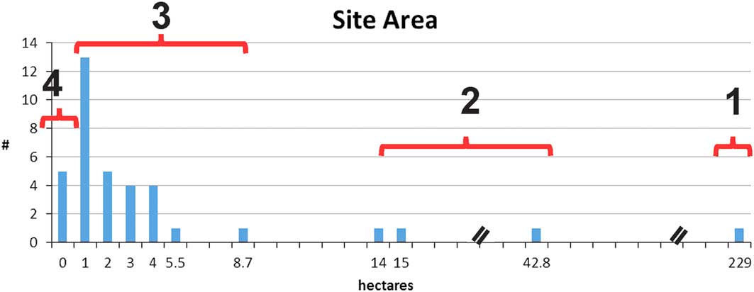
The data collected by the IRSP also document the internal ranking of centres within the Izapa kingdom. We propose a three-tiered hierarchy of political centres based on site size and the range of architectural features (Figure 7), the latter providing qualitative criteria for hierarchical ranking (Table 1). An administrative hierarchy differs from a settlement hierarchy (Flannery Reference Flannery1998), and here we infer that the former is reflected by the range of architectural features. Administrative functions can include economic activities, such as taxation, redistribution or storage. Political functions may include legal adjudication, waging war and establishing peace, as well as politico-religious activities that justify the elite classes’ right to rule. Although Flannery (Reference Flannery1998) focuses on the architectural feature of a king’s palace to infer administrative activity, a range of political and/or administrative activities can be used to contextualise quantitative measures of site sizes. Our interpretation combines the quantitative patterns reported in Figure 7 with the qualitative attributes listed in Table 1.
Regional rank size of Izapa-kingdom centres defined by their size and architectural features.

Qualitative criteria for Izapa kingdom settlement hierarchy.

The Izapa capital was the largest city in the kingdom, and the only one with hundreds of stone monuments. The history/mythology commemorated and publicly displayed on stone stelae (Figure 2) was unique to the capital. At its largest documented extent during the Escalón phase, Izapa measured 229ha, with a population of 5725, based on a standard of 25 persons/ha. This is a conservative estimate for the pre-Hispanic Mesoamerican urban population. For example, at Monte Albán during the Late Formative period, a density of 23–46 persons/ha was suggested (Blanton Reference Blanton1978: 44). In the Maya area, a similar range of 21–39 persons/ha was estimated for Chunchucmil, and as many as 120 persons/ha for Copan (Webster Reference Webster2008: 120; Hutson Reference Hutson2016: 107). One hectare is approximately the size of a rugby field. So, 25 persons/ha is not a particularly dense population estimate for an early urban setting. If an extended family of 25 people occupied a rugby field, this would be low-density urbanism, with space for infield food production (Isendalh & Smith Reference Isendahl and Smith2013).
The total area of the Izapa capital during the Escalón phase was probably larger than 229ha (and population level higher). If some portion of dwellings at Izapa left no remains on the surface, they would not be detected by our lidar-based survey methodology. Another methodological issue is that our pedestrian survey documented that the greatest number of mounds was occupied during the Escalón phase. The Izapa capital’s apogee, however, came later, following erection of the stelae, and the architectural core of the site expanded when groups A and D were built during the Guillén phase. Our survey method may be imperfect, but no more so than all diachronic, archaeological proxy measures of settlement.
Beneath Izapa, three second-tier centres are defined based on their architectural features and smaller sizes, ranging from 14–43ha (Table 1). The population of these sites would have ranged from 350–1075 people—less than 20 per cent of the Izapa capital’s population. First- and second-tier centres each have between three and four plazas, along with at least one ballcourt and one E-Group—the latter an architectural complex usually understood to have astronomical referents (Friedel et al. Reference Freidel, Chase and Dowd2017). Aimers and Rice (Reference Aimers and Rice2006: 93), however, propose that E-Groups were constructed not for actually sighting equinox and solstice occurrence, but instead served political functions “as dramatic displays of rulers’ agency within divinely directed cosmos”. Many E-Groups in the Maya lowlands were first built during the Middle Formative period, and achieved their largest size during the Late Formative (Doyle Reference Doyle2012); this is precisely what we have documented at the Izapa capital (Rosenswig et al. in press). While none of Izapa’s secondary centres have yet been excavated, we collected Middle and Late Formative-period pottery from the surfaces of their ballcourts and E-Groups. These distinct architectural features indicate that a similar range of rituals were undertaken at the largest centres throughout the kingdom.
The third-tier centres each have a platform stage south of their main northern mound, along with one or two plazas aligned to the south-south-west. Larger third-tier centres have three architectural features on the stage (like those observed for first- and second-tier sites). It is clear that public rituals, framed by each site’s northern mound and the Tacaná and Tajumulco volcanoes, were replicated at all first-, second- and third-tier centres. We infer that there were at least three levels of political actors who enacted related rituals that reinforced each others’ power. Third-tier centres cover 1–9ha, with approximately 25–225 residents. Fourth-order centres consist of single plazas without northern platforms. These latter (and smaller) centres had culturally defined space oriented in the same direction as larger centres, but lacked other characteristic architecture. Another tier of small hamlets probably existed without any mounded architecture, and may have been similar in population size to fourth-tier centres. They are, however, not visible on the ground’s surface, and were therefore not captured with our lidar-based survey methodology.
Kingdom limits and borders
The architectural/administrative hierarchy of the Izapa-kingdom centres demonstrates political integration within the polity. Given their consistency in orientation, layout and architectural features, we use centre distribution to determine the limits of the Izapa polity.
Southern extent
The southern limit of the Izapa kingdom is defined by a lack of occupation south of Las Viudas. Located 22km from the capital, Las Viudas is the second largest monumental centre in the Izapa kingdom and was halfway to the Pacific Ocean (Figure 1). While the limit of the IRSP lidar collection area is only 5km south of Las Viudas (Figure 3), very sparse 700–100 BC occupation (monumental or otherwise) is documented in the coastal plain survey zone (Rosenswig Reference Rosenswig2008). We can identify no ecological or environmental explanation for the lack of occupation between Las Viudas and the estuary at this time. Instead, the kingdom’s southern extent was presumably a political construct, reflecting the range of administrative efficiency by rulers in the capital, and the defensibility of the polity’s inhabitants from neighbouring polities.
At 22km from Izapa, Las Viudas lies within the cross-culturally recorded distance (of approximately 30km) for the effective limit of direct control, given the return travel distance by foot in a single day (Spencer Reference Spencer1990: 7; Hansen Reference Hansen2000: 17). Return travel to Las Viudas would have taken less than one day if travelling downriver by canoe from the Izapa capital and then walking back. All Izapa-kingdom centres between the Cahuacán and Suchiate Rivers are connected by river (Figure 3). River travel would have facilitated rapid movement to any lower-order centre from the Izapa capital, and less than a half-day’s walk back. Administrative hierarchy may, therefore, have been reinforced militarily, contributing to both internal cohesion and defence from outsiders.
Eastern extent
The internal architectural consistency of the Izapa-kingdom centres contrasts with that of the neighbouring El Ujuxte and Takalik Abaj kingdoms to the east and south-east (Figure 8). The Izapa and El Ujuxte capitals are 44km apart, beyond the approximate 30km range of return travel in a single day, and delayed further by multiple river-crossings. Built 58km apart, the Izapa and Takalik Abaj capitals are spaced far enough apart that each could almost have had their own 30km-radius territories.
The boundaries of the Izapa kingdom are indicated by the red circle, and the neighbouring kingdom capitals of El Ujuxte and Takalik Abaj are also marked.

Although IRSP lidar coverage does not extend far into Guatemala, when combined with data from previous investigations, the Izapa kingdom’s eastern limit can be estimated. Four small monumental centres were documented by lidar within 3km of the modern Mexico-Guatemala border (Figure 4; Figures S43–48). In addition, Shook’s (Reference Shook1965) map—created long before the ‘Izapa pattern’ was defined—shows the large centre of El Jardín (Figure S47), and reveals that this site clearly conforms to the layout and orientation of the Izapa kingdom. At approximately half the size of Las Viudas, El Jardín has an E-Group, a ballcourt and four plazas south of the northern pyramid and platform (Figure S47). Las Viudas (22km from Izapa) and El Jardín (14km from Izapa) appear to define the kingdom’s southern and eastern borders. A third border centre is El Sitio, located directly between Izapa and Takalik Abaj (Figure 8). El Sitio is also located strategically at the base of a mountain pass that leads down from the Sierra Madre. The site is located within the modern town of the same name, but similar architecture is still evident when visiting the site today (OSM: S66–67). There is clear consistency in architectural features, site layout and orientation between these Guatemalan centres and those across the Mexican border.
Western extent
The western limit of the Izapa kingdom is the Cahuacán River, beyond which sites have different architectural design conventions. Pedestrian survey and artefact collection confirms that four monumental sites documented by lidar (sites 40, 42, 43, 44) are coeval with the Izapa kingdom. Although each of these sites have some architectural components expected for Izapa-affiliated sites, they do not conform to the ‘Izapa pattern’ (Figures S49–53) and so we do not interpret them as being part of the polity. The people who organised the construction of the sites west of the Cahuacán River may have lacked the specialised architects, planners and astronomers employed to build the Izapa-kingdom centres. Alternatively, the people living to the west of the Cahuacán River deliberately set up their centres differently. Site 40 provides an example of such a monumental site (Figure 9). Here, the first inconsistency is site location, as none of the Izapa kingdom’s cities were located in such a precarious river flood channel. Second, the architecture at site 40 is not arranged akin to those of the Izapa kingdom. Although a rectangular platform with a mound on top is present, it was located to the north-west, rather than to the north-north-east, of the other mounds, and against the river’s western terrace. Any ceremonies undertaken on the platform would not have been framed by the Tacaná and Tajumulco volcanoes when viewed from other mounds or plazas. Third, some of site 40’s mounds have no clear line of sight to the platform, due to the construction of intervening monumental buildings. Fourth, the plazas at site 40 were not aligned with each other, as were those at all of the Izapa-kingdom centres east of the Cahuacán River. While the other three monumental sites west of the Cahuacán River diverged less obviously from the architectural standards of the Izapa kingdom, they do not contain symmetrical plazas or align with the conical pyramid mound at each site (Figures S49–53). The inhabitants of these four sites either could not or did not want to follow the standards of the Izapa kingdom. The lack of a large kingdom west of the Cahuacán River may account for why there was no secondary centre protecting this side of the Izapa kingdom’s territory.
Monumental centre (site 40) beyond the western limit of the Izapa kingdom.

Northern extent
The Izapa kingdom’s northern limit is the capital itself. Our lidar data end less than 2km north of Izapa, where the terrain changes from the gently sloping piedmont to rise dramatically into the Sierra Madre. No Formative-period sites are known in this mountainous zone, and travel uphill and upriver from Izapa would have made this region less accessible than those areas downstream. That the Izapa capital defined the northern limit of the polity is consistent with the defensive placement of secondary centres along the south and east edges of the kingdom’s territory. Such an arrangement would have Izapa, Las Viudas, El Jardín and El Sitio, as well as the Cahuacán River, protecting the perimeter of the kingdom and defining a territory of approximately 450km2, determined by Google Earth as the area within the polygon in Figure 8. This is the minimum size that the kingdom could have been. Future work in Guatemala—and upslope in Chiapas—may increase the known extent of the kingdom, but we would not expect the total polity size to increase dramatically.
Concluding remarks
Why was the Izapa kingdom established on the Soconusco piedmont following a millennium of settlement focused on the coastal plain? One reason was clearly political. The local Soconusco tradition was one of successive regimes that spatially differentiated themselves from their predecessor: 1) early centres on the swamp margins of the Mazatán zone; 2) the late Early Formative-period capitals on the Coatán River; 3) La Blanca at the other end of the Soconusco (Clark & Pye Reference Clark and Pye2011). A second reason was environmental: the Soconusco piedmont receives over twice the amount of annual rainfall as the coastal plain. This allows for increased maize production and also provides the ideal environment for growing cacao (Lowe et al. Reference Lowe, Lee and Espinoza1982: 62–72). Such agricultural and climatic factors would have been particularly attractive to peoples reliant on maize to feed larger, more aggregated populations.
How was Izapa organised? We employ the concept of a ‘kingdom’ to describe a hierarchical polity ruled by a king, which consisted of a capital and affiliated lower-tier centres. This avoids the typological exercise of whether Izapa was a complex chiefdom or a state. Clark (Reference Clark2016) defines a kingdom in this way, and also describes many of the Middle Formative polities in Chiapas as kingdoms. Love (2011: 52–53) uses the city-state concept (proposed by Hansen Reference Hansen2000) to define Mesoamerica’s Pacific polities in similar terms as territorially small and politically independent, hierarchically organised political entities within a network of peers. Rather than defining what Izapa was typologically, our goal is to reconstruct how this early kingdom was organised.
The Izapa kingdom’s territory was arranged to maintain internal cohesion and external sovereignty. The physiographical, architectural and, presumably, cosmological realms reinforced the authority of Izapa’s elite. During its occupation between 700–100 BC, the kingdom encompassed dozens of monumental centres, forming a tightly integrated settlement hierarchy. While the site of Izapa reached its political apogee during the Guillén phase (300–100 BC), during which most of its stelae were erected, our lidar and pedestrian survey data indicate that a regional kingdom was established by Escalón times (700–500 BC). The kingdom was compact, with all associated centres located within 22km of the capital. The Izapa capital’s location on the edge of the piedmont facilitated travel downriver to subsidiary centres. Large secondary centres were arranged around the perimeter of the kingdom, which protected the inhabitants of smaller Izapa-kingdom sites from neighbouring kingdoms. All centres in the Izapa kingdom were arranged and oriented according to the same principles. This contrasts with the neighbouring kingdoms of Takalik Abaj and El Ujuxte to the south-east, which had their own principles of site organisation.
The Izapa capital was clearly urban, as were nearby centres such as Takalik Abaj and El Ujuxte. But what of the lower order centres within each kingdom? Their status as ‘urban’ depends on how the term is defined. With populations of under 2000 people, Izapa’s secondary centres would not be deemed urban by many analysts. Is population size all that really matters? Considering the range of political-religious functions inferred by their architectural features, there appears to be minimal difference between Izapa and its secondary centres. If we accept that the Classic-period Maya (AD 300–900) represented a city-state culture, and that each centre which possessed its own emblem glyph was an independent polity, individual city-states could then be quite small. Motul de San Jose, for example, had an estimated population of 1200, yet had its own emblem glyph and royal court (Foias et al. Reference Foias, Halperin, Moriarty and Castellanos2012). If population size alone does not determine urban status, then we return to a functional definition of urbanism. We propose that the Izapa kingdom’s capital and secondary centres were urban, and that the third-tier centres could be considered so too. The construction of politico-religious architecture and its continued use by a class of socially ranked people (who were aligned with their superiors in the Izapa capital) mean that these second- and third-tier centres formed a long-lasting, integrated system of political organisation.
Acknowledgements
Data collection and analysis was funded by the National Science Foundation (grants BCS-0947787 and BCS-1418988) and the UAlbany Center for Social and Demographic Analysis, funded by NICHD (R24 HD044943). INAH’s Consejo de Arqueología provided fieldwork permits. Our gratitude to the people of the Soconusco have been most gracious for granting us permission to work on their land. M.E. Smith, M. Masson and two anonymous reviewers provided helpful input on earlier drafts of this paper.
Supplementary material
To view supplementary material for this article, please visit https://doi.org/10.15184/aqy.2018.166