INTRODUCTION
The patterns and drivers of regional-scale heterogeneity of biological communities in the mega-diverse western Amazon basin remain poorly understood (Terborgh & Andresen Reference TERBORGH and ANDRESEN1998, Tuomisto et al. Reference TUOMISTO, RUOKOLAINEN and YLI-HALLA2003), and assessing the level of meso-scale community heterogeneity within spatially dominant habitat types, such as unflooded (terra firme) and floodplain forests, is a major challenge (Vormisto et al. Reference VORMISTO, SVENNING, HALL and BALSLEV2004). There has been considerable discussion of patterns of Amazonian plant community heterogeneity at the meso-, or landscape, scale (Hubbell Reference HUBBELL2001, Phillips et al. Reference PHILLIPS, VARGAS, MONTEAGUDO, CRUZ, ZANS, SANCHEZ, YLI-HALLA and ROSE2003, Pitman et al. Reference PITMAN, TERBORGH, SILMAN, NUNEZ, NEILL, CERON, PALACIOS and AULESTIA2001, Tuomisto et al. Reference TUOMISTO, RUOKOLAINEN, KALLIOLA, LINNA, DANJOY and RODRIGUEZ1995) but comparatively little on patterns of vertebrate diversity.
The composition and structure (relative species abundances) of Amazonian primate communities have been studied at local scales (Bennett et al. Reference BENNETT, LEONARD and CARTNER2001, Emmons Reference EMMONS1984, Haugaasen & Peres Reference HAUGAASEN and PERES2005a, Peres Reference PERES1993, Soini Reference SOINI1986) and at the regional scale (>105 km2, Freese et al. Reference FREESE, HELTNE, CASTRO and WHITESIDES1982, Peres Reference PERES1997). Little is known, however, about patterns of variation in Amazonian primate community structure at the meso-scale (103–105 km2), and the only published primate surveys at this scale (Buchanan-Smith et al. Reference BUCHANAN-SMITH, HARDIE, CACERES and PRESCOTT2000, Christen & Geissmann Reference CHRISTEN and GEISSMANN1994, Heymann et al. Reference HEYMANN, ENCARNACIÓN and CANAQUIN2002) did not quantify species abundance or biomass. As sessile primary producers, plants would be expected to be sensitive to fine-scale changes in abiotic conditions (Fine et al. Reference FINE, MESONES and COLEY2004, Tuomisto et al. Reference TUOMISTO, RUOKOLAINEN, KALLIOLA, LINNA, DANJOY and RODRIGUEZ1995) and may also experience dispersal limitation (Hubbell Reference HUBBELL2001), whereas vertebrate taxa such as primates may be able to adjust to meso-scale variation in resource availability with limited change in their community composition and structure. We might therefore expect primate communities to be stable with respect to microhabitat change or geographic distance at spatial scales ranging from hundreds of thousands to millions of hectares.
To test this hypothesis, we synthesized published and unpublished primate species composition and aggregate abundance and biomass data from surveys collected across the Region of Madre de Dios (MDD) in south-eastern Peru and quantified community spatial heterogeneity. The region encompasses millions of hectares yet represents only a fraction of 1% of the Amazon basin. This scale is well below that typical for turnover in Amazonian primate species (http://www.iucnredlist.org/mammals/data_types, Patterson et al. Reference PATTERSON, CEBALLOS, SECHREST, TOGNELLI, BROOKS, LUNA, ORTEGA, SALAZAR and YOUNG2003), thereby allowing us to measure community heterogeneity, independent of species replacements. While primate species richness is only a fraction of that of plants, south-western Amazonian primate communities are among the world's most diverse (Emmons Reference EMMONS, Fleagle, Janson and Reed1999, Terborgh Reference TERBORGH1983) and may be sufficiently species-rich to display variability in community structure at this scale. To assess how habitat heterogeneity may affect primate communities across the region's relatively intact tracts of tropical forest, we examined patterns of primate community similarity as a function of geographic location, sub-basin position, location north or south of the Madre de Dios River (to assess its potential as a dispersal barrier), and major forest type (terra firme vs floodplain).
While the forest of MDD remains largely intact and therefore appropriate as a landscape to assess natural community heterogeneity, a rapidly growing human population has begun to impact primate populations at sites throughout the basin. To investigate how hunting interplayed with natural community heterogeneity, we also assessed community composition and structure as a function of hunting pressure and forest management regime. Based on previous studies, we expected that hunters would selectively remove the most abundant large-bodied species (Ohl-Schacherer et al. Reference OHL-SCHACHERER, SHEPARD, KAPLAN, PERES, LEVI and YU2007, Peres Reference PERES2000, Schulte-Herbrüggen & Rossiter unpubl. data, http://student.biology.ed.ac.uk/general/awards/reports/2003_davis/Herbruggen-2003.pdf). Based on evidence suggesting density undercompensation of non-hunted medium-bodied species in moderately hunted sites elsewhere in Amazonia (Peres & Dolman Reference PERES and DOLMAN2000), we predicted that abundances of smaller and rarer species would increase at hunted sites to compensate for hunting-induced reduction of relatively abundant larger species. We further predicted that hunting-induced population declines in larger species would increase the structural heterogeneity of primate communities.
METHODS
Study area
We compiled data from line-transect surveys at 37 forest sites in the Madre de Dios (MDD) watershed of south-eastern Peru (Figure 1, Appendix 1), 12 of which were conducted by SP. This transition region between the Andean foothills to the west and the vast Amazon lowlands to the north and east encompasses an area of approximately 85 000 km2. Seven of the sites lie south of the main channel of the Madre de Dios River, while the rest were grouped into four additional subregions, all north of the river. Annual rainfall averages 2200–2700 mm, with a distinct dry season between May and September (Botanical Research Institute of Texas (BRIT) 2007 http://atrium.andesamazon.org, Osher & Buol Reference OSHER and BUOL1998). Elevation ranges from 190 to 440 m asl along an east-to-west gradient. All sites were located within largely intact primary lowland rain forest, as the MDD department retains over 90% forest cover (Phillips et al. Reference PHILLIPS, ROSE, MONTEAGUDO and VARGAS2006).
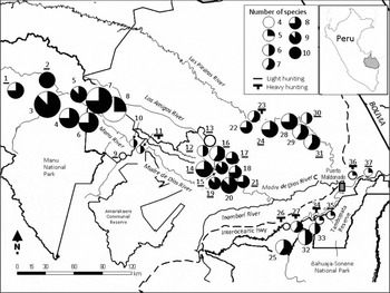
Study area in Madre de Dios, south-eastern Peru, including the 37 survey sites considered in this study (Appendix 1). Pie charts indicate primate species richness, whereas symbol sizes are proportional to the aggregate biomass of each primate assemblage (0–50 kg, 50–100 kg, 100–300 kg, 300–500 kg, > 500 kg per 10 km surveyed). The dashed line indicates the Inter-Oceanic Highway, which is currently being paved.

The basin's two predominant habitat types are elevated, unflooded terra firme forest, and supra-annually flooded, well-developed floodplain forest (Terborgh & Andresen Reference TERBORGH and ANDRESEN1998, Thieme et al. Reference THIEME, LEHNER, ABELL, HAMILTON, KELLNDORFER, POWELL and RIVEROS2007). Floodplain forests of the south-western Amazon are inundated far less frequently and for much shorter periods than those of the central and western Amazon, though they still receive nutrient-rich suspended sediments from the Andes, rendering their soils more productive than those of surrounding terra firme forest (Hamilton et al. Reference HAMILTON, KELLNDORFER, LEHNER and TOBLER2007, Salo et al. Reference SALO, KALLIOLA, HÄKKINEN, MÄKINEN, NIEMELÄ, PUHAKKA and COLEY1986, Terborgh Reference TERBORGH1983). The percentage of terra firme forest at our survey sites ranged from 0% to 100%. Transect lines at 16 sites were established in a single known forest type; for all others, we overlaid the transect lines with a forest cover map in a GIS to calculate the percentage of terra firme forest along transects. Two less common habitat types – Guadua bamboo thickets in upland forest and Mauritia flexuosa-dominated palm swamps in floodplains – also occur in this region but were excluded from the surveys.
Approximately 37% of the study region is registered under strict protection, while another 8% is managed for sustainable use (MINAM 2010), 6% is privately managed for restricted-use activities that preclude hunting (conservation, Brazil nut and tourism concessions, BRIT 2007 http://atrium.andesamazon.org, E. Tatum-Hume pers. comm., MINAM 2010, Sociedad Peruana de Derecho Ambiental (SPDA) unpubl. data), and 11% is within an uncontacted indigenous reserve. However, de facto land-use restrictions vary across all land management categories. For example, subsistence hunting by Matsigenka Indians is permitted within the otherwise strictly protected Manu National Park. In addition, some areas of restricted use were heavily hunted prior to reserve establishment and immediately prior to our sampling. Remaining areas, including areas of contacted indigenous groups, face unrestricted (direct) human resource use and have been subjected to varying levels of hunting pressure.
Field surveys
Primate communities at all sites were surveyed using line transects of 2–7 km in length, between 1997 and 2007, with observers systematically alternating transects to avoid observer bias. Transects were surveyed an average of 15.6 (± 11.4 SD) times each. Diurnal surveys were conducted on mornings with no precipitation from 06h00 to 11h00, thereby excluding the night monkey (Aotus nigriceps), the only nocturnal primate in the region. For each primate group detected, we recorded the time, species identity, group size, sighting location, perpendicular distance from the transect, and detection cue. Field procedures used in our surveys are described in detail in Peres (Reference PERES1999a). For the purpose of analysis, individual transects within a subregion were considered unique sites if they represented a unique combination of river bank, habitat type and hunting pressure. Total survey effort per site ranged from 25 to 315 km (mean 123 km, Appendix 1), with a cumulative survey effort of 4537 km across 81 individual transects at 37 sites. Sites were grouped into five subregions (corresponding to the Manu, Los Amigos, Las Piedras and Tambopata sub-basins and a section of the main channel of the MDD River (North-MDD subregion), Figure 1), as well as two main forest habitats, three levels of hunting pressure and three forest management regimes.
Data analysis
We used a kilometric index of groups encountered per 10 km walked (elsewhere referred to as encounter rate, sensu Buckland et al. Reference BUCKLAND, ANDERSON, BURNHAM, LAAKE, BORCHERS and THOMAS2001) to control for overall differences in sampling effort (Peres Reference PERES1997). Due to small sample sizes for some species and variability in perpendicular distances that prevented pooling data among sites, our data did not meet the minimum prerequisites for estimation of density (Buckland et al. Reference BUCKLAND, ANDERSON, BURNHAM, LAAKE, BORCHERS and THOMAS2001) for all sites. Relative estimates of animal abundances were therefore used to allow comparison of community heterogeneity across the study region. We quantified a relative measure of species abundance at each site (hereafter, abundance) by multiplying the site-specific number of groups of each species encountered per 10 km walked by its mean group size, using values from all reliable group counts at each site for which data were available (Galetti et al. Reference GALETTI, GIACOMINI, BUENO, BERNARDO, MARQUES, BOVENDORP, STEFFLER, RUBIM, GOBBO, DONATTI, BEGOTTI, MEIRELLES, NOBRE, CHIARELLO and PERES2009). Data for one site (Boca Manu) were derived from published density estimates of three size-graded groupings of primate species (Nuñez-Iturri Reference NUñEZ-ITURRI2007, Nuñez-Iturri & Howe Reference NUÑEZ-ITURRI and HOWE2007, Terborgh et al. Reference TERBORGH, NUÑEZ-ITURRI, PITMAN, CORNEJO, ALVAREZ, SWAMY, PRINGLE and PAINE2008). We multiplied the proportion of each species in its size class across three hunted sites in MDD by the abundance estimate of the same size class at Boca Manu to derive the abundance estimates for individual species at this site. For each site, we also calculated the aggregate relative biomass of each species (hereafter, biomass: Galetti et al. Reference GALETTI, GIACOMINI, BUENO, BERNARDO, MARQUES, BOVENDORP, STEFFLER, RUBIM, GOBBO, DONATTI, BEGOTTI, MEIRELLES, NOBRE, CHIARELLO and PERES2009) by multiplying the mean adult body mass of each species in the region by its abundance value at each site.
To estimate the extent of spatial structure in our data, we ran a partial spatial regression using the Spatial Analysis in Macroecology software (SAM, v 4.0, Rangel et al. Reference RANGEL, DINIZ-FILHO and BINI2010) with hunting pressure, forest habitat type, subregion, latitude and longitude to identify the amount of variance in species richness, aggregate abundance and aggregate biomass explained by geography and environmental variables, respectively.
We compared species richness of survey sites north and south of the MDD River using a t-test. We evaluated species richness and log10-transformed aggregate abundance and biomass at sites with different forest types (expressed as percentage of terra firme forest), management categories, hunting pressure (three ordinal categories based on information from landowners, researchers, guides, forest guards, published and unpublished reports and personal observations; Peres Reference PERES2000), and subregions, entering the predictors both individually, using one-way ANOVA, and in combination, using a set of generalized linear mixed models (GLMMs). GLMMs for species richness and aggregate abundance/aggregate biomass used a Poisson and a Gaussian error structure, respectively. Given the wide variation in survey effort, we also included census effort (km walked) as a covariate in each set of models. Subregion was strongly correlated with elevation (r = −0.83), longitude (r = −0.77) and latitude (r = 0.86, P < 0.01 in all cases). Subregions thus served as both a measure of geographic location and as a proxy of environmental factors beyond the scope of this study, such as forest structure, tree species composition and soil types, all of which may affect primate assemblage structure. To account for possible effects of geography on community structure, we therefore treated subregion in each set of GLMM models as a random factor, within which the environmental covariates varied.
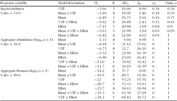
Following Burnham & Anderson (Reference BURNHAM and ANDERSON2002), we calculated the AIC, corrected for small sample size (AICc), for candidate GLMMs of each of the three response variables (species richness, aggregate abundance (log10 x + 1), and aggregate biomass (log10 x + 1)) using the AICcmodavg package within the R statistical framework (R Development Core Team, v. 2.10.1). In each case, models were ranked according to their likelihood of being the best in each set of candidate models by rescaling the AICc values such that the model with the lowest AICc had a value of 0, i.e. Δi = AICi –AICmin. Models for which Δi > 2 were considered unlikely to be appropriate (Burnham & Anderson Reference BURNHAM and ANDERSON2002). We also computed Akaike weights (ωi) for each model such that the sum of weights for all models for each response variable equals 1. These weights are approximate probabilities that a given model is the best model in its candidate set, so the values also provide an estimate of model selection uncertainty (Burnham & Anderson Reference BURNHAM and ANDERSON2002).
We examined differences in abundance and biomass of individual species with respect to the same predictor variables using Kruskal–Wallis tests. To examine the likelihood of density compensation, we ran Spearman correlations among the abundance and biomass values of individual species.
We examined heterogeneity in primate species composition and abundance using Primer (v.6, PRIMER-E Ltd., Plymouth, UK). To evaluate similarities in species composition among sites, we constructed a pairwise similarity matrix of species occupancy, based on the Jaccard similarity index using species presence/absence data. We used a partial Mantel test (zt software, Bonnet & Van de Peer Reference BONNET and VAN DE PEER2002) to examine pairwise species similarity values among sites located on the same side (either north or south) of the MDD River with those located on opposite sides of the river while controlling for geographic distance.
We assessed spatial patterns of community structure using non-metric multidimensional scaling (NMDS, Clarke & Warwick Reference CLARKE and WARWICK2001). We initially square root-transformed the abundance and biomass data for each species at each site, to decrease over-dominance of abundant species, and converted these two datasets into separate pairwise similarity matrices based on the Bray–Curtis similarity coefficient, to exclude treatment of joint absences as a sign of similarity. We then tested whether patterns of community structure differed among sites as a function of forest type, hunting pressure, restrictions on human use, and subregion using Analysis of Similarities tests (ANOSIM, Clarke & Green Reference CLARKE and GREEN1988). The ANOSIM statistic (R) behaves like a correlation coefficient, ranging from −1 to +1, with significantly positive R-values implying that samples (sites) within groups are more similar than expected by chance. We examined the relative importance of the four main environmental variables, as well as geographic distance among sites, in determining primate community similarity, using Primer's BIO-ENV function (Clarke & Warwick Reference CLARKE and WARWICK2001) and a simple Mantel test, respectively. We also conducted partial Mantel tests to examine the significance of each of the environmental variables on community composition and structure, while controlling for pairwise distances between sites.
RESULTS
Species richness and composition
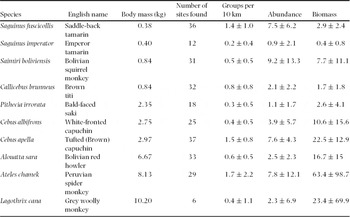
We recorded 10 of the 13 primate species known to occur in Madre de Dios (Groves Reference GROVES, Wilson and Reeder2005, Table 1) in sufficient numbers to conduct analyses. Observations of the night monkey (Aotus nigriceps) were excluded from the analysis because detectability of this species is inconsistent during daylight hours, and Goeldi's marmoset (Callimico goeldii) and pygmy marmoset (Cebuella (Callithrix) pygmaea) were not recorded at any of the sites. We recorded between four and 10 primate species at each site (Figure 1, Appendix 1), with 10 species recorded at only one hunted site (Tayakome) within Manu National Park. Only one species, brown capuchin (Cebus apella), was found at all sites (Table 1), whereas three species – woolly monkey (Lagothrix cana), emperor tamarin (Saguinus imperator) and bald-faced saki (Pithecia irrorata) – were recorded at only 6, 12 and 18 sites, respectively, all north of the MDD river.
Summary of 10 primate species occurring at 37 survey sites considered in this study, including mean (± SD) body mass, groups per 10 km walked, numerical abundance (individuals per 10 km walked) and biomass (kg per 10 km walked). Species are ordered by body mass, from smallest to largest. Mean body mass values derived from the following sources (as available): Clutton-Brock & Harvey (Reference CLUTTON-BROCK and HARVEY1977), Emmons (Reference EMMONS1984), Robinson & Redford (Reference ROBINSON and Redford1986), Ayres et al. (Reference AYRES, LIMA, MARTINS, BARREIROS, Robinson and Redford1991), Mittermeier (Reference MITTERMEIER, Robinson and Redford1991), Peres (Reference PERES1993), Emmons (Reference EMMONS1997). Species nomenclature follows Groves (Reference GROVES, Wilson and Reeder2005).

Sites north of the Madre de Dios River were thus more species-rich (mean ± SD = 7.3 ± 1.6; range = 4–10 species) than those south of the river (5.7 ± 1.1; range = 4–7 species, t-test: t = –2.47, df = 35, P = 0.018). Despite the absence of three species from all sites south of the river, pairwise similarity in species composition was not correlated with river bank once we controlled for geographic distance among sites (partial Mantel; r = −0.051, P = 0.278); geographic distance itself correlated weakly with species composition (simple Mantel: r = −0.164, P = 0.020).
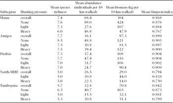
Species richness was highest in the Amigos and Manu subregions (F4,32 = 3.05, P = 0.03, Table 2, Appendix 1) and was positively correlated with proportion of terra firme forest (r = 0.463, P = 0.004, N = 37 sites). Although overall species richness did not differ among management regimes or levels of hunting pressure (one-way AVOVA, P > 0.05 in both cases), heavily hunted sites had fewer of the three largest species (F2,34 = 4.44, P = 0.02) than the subset of 15 non-hunted sites, and at least one large-bodied species was likely driven to local extinction at five of the hunted sites (Sites 1, 26, 34, 36 and 37, Figure 1 and Appendix 1). Community composition was consequently more similar among the 15 non-hunted sites (mean pairwise similarity = 74.1% ± 13.1%, range = 38–100%) than among the 22 hunted sites (mean similarity = 57.7% ± 16.6%; range = 25–100%; t = −8.40, df = 228, P < 0.001).
Summary statistics for mean species richness, aggregate abundance, aggregate biomass and Simpson diversity index (1 – λ') for survey sites across three levels of hunting pressure within each subregion. Tambopata is located south of the Madre de Dios River (all other subregions north of the river).

Aggregate abundance and biomass
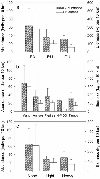
Primate abundance and biomass estimates across all 37 sites were highly variable (Figure 2, Table 2). We encountered between 1.7 and 17.8 groups per 10 km (mean ± SD = 7.9 ± 4.4) across all survey sites, while aggregate abundance ranged from 15.5 to 164.5 individuals per 10 km walked (Appendix 1). Aggregate biomass varied even more than abundance, ranging from a low of 14 kg per 10 km in a hunted site along the MDD River (Reserva Amazonica) to 615 kg per 10 km in a non-hunted site in Manu (Cumerjali); even among non-hunted sites, biomass varied by more than an order of magnitude (34–615 kg per 10 km). Aggregate primate abundance and biomass were higher in strictly protected areas than in zones of direct human use (abundance F2,34 = 4.10, P = 0.025, biomass F2,34 = 7.85, P = 0.002; Figure 2a), and higher at non-hunted than at hunted sites (abundance F2,34 = 9.50, P = 0.0005, biomass F2,34 = 7.83, P = 0.002; Figure 2c). Neither aggregate abundance nor biomass varied with the proportion of terra firme forest (P > 0.05 in both cases).
Mean (± SD) aggregate primate abundance (individuals per 10 km walked) and biomass (kg per 10 km walked) values: by land-management category, PA = strictly protected area, RU = restricted forest resource extraction, DU = direct forest resource extraction (a); by subregion, N-MDD = North bank of the Madre de Dios River, Tambo = Tambopata (b); and by level of hunting pressure (c).

Primate–environment relationships
The partial spatial regression using two environmental variables (hunting, per cent terra firme forest), together with latitude and longitude, to explain species richness and site-level abundance and biomass showed that geographic position was a contributing factor to any explanatory power of the environmental variables. Spatial location contributed 53–79% of all explained variation in the three response variables and alone accounted for 24% of the total explained variation in species richness, 35.4% of aggregate abundance and 51.2% of aggregate biomass. These values decreased to 0.2%, 13.1% and 28.4%, respectively, when subregion was included as a predictor variable, which supported the nesting of random effects within subregion in the GLMM to help account for the spatial structure identified in the partial spatial regression.
No single explanatory model for species richness was clearly supported. The model including the single covariate, per cent of terra firme forest, was judged to be the best approximating model in the set of seven candidate models, although its Akaike weight of 0.36 suggests considerable model selection uncertainty (Table 3). The simplest models, with hunting pressure as a single covariate, were the only GLMMs supported by the data for both aggregate abundance and biomass. Hunting pressure accounted for over 97% and 85% of the modest amount of overall variance that could be explained in aggregate abundance (R2 = 24.7%) and biomass (R2 = 34.5%), respectively.
Summary of generalized linear mixed model (GLMM) selection results assessing the association between primate species richness, aggregate abundance, and aggregate biomass and a set of candidate GLMMs, assigning subregion as a random factor (see text and Figure 1). Model fit based on the global model is shown for each response variable as the percentage deviance explained (% dev). For each model, LL = log-likelihood; K = number of estimable parameters, AICc = Akaike's information criterion for small sample sizes; Δi= the difference between a given model and the best model, in units of AICc; ωi = Akaike weight, interpreted as the probability that the model best represents the data.%TF = Percentage of terra firme forest, Hunt = Hunting pressure (None, Light, Heavy), Effort = km of survey effort.

Patterns of community structure and heterogeneity
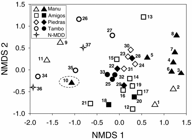
Primate community structure was highly variable across all 37 sites (Figure 3), but determinants of the heterogeneity were unclear. Community similarity over all 666 pairwise comparisons ranged from 19% to 90% (mean ± SD = 59% ± 12%) using abundance values, and from 16% to 90% (56% ± 15%) using biomass values.
NMDS ordination of the primate community at 37 survey sites coded by location in one of five subregions. Stress = 0.17. Hunting increased community heterogeneity (displayed as relative distance between pairs of sites), both overall and within individual subregions. The grouping of the 15 non-hunted sites (filled symbols) by subregion shows spatial heterogeneity independent of the effects of hunting. Limonal (Site 10) appears as an outlier, and its extreme separation from all other non-hunted Manu sites and its location at the edge of Manu NP suggest that it has likely experienced greater hunting pressure than officially reported. Numbers correspond to site numbers, ordered west to east (Appendix 1). N-MDD = North-MDD; Tambo = Tambopata.
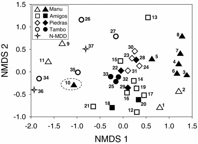
The potential drivers of community structure that we examined were, for the most part, significant but weak predictors of primate community similarity. Primate community structure across MDD could be grouped most clearly by subregion – based on either species abundance (Global ANOSIM Rabundance = 0.248, P = 0.001) or biomass (Global Rbiomass = 0.299, P = 0.001, Figure 3). There were significant pairwise differences between most subregions, and differences between North-MDD and both Amigos and Piedras were marked (pairwise Rbiomass > 0.9, P < 0.05 in both cases). The Manu subregion differed from the others by the high biomass values for the two largest-bodied ateline primates (spider monkey, Ateles chamek, and woolly monkey). Woolly monkeys were recorded only in the Manu subregion, and abundance of spider monkeys was significantly higher in the Manu subregion than in other subregions (Kruskal–Wallis test H4 = 10.4, P = 0.034). High abundances of two rarer species (bald-faced saki and emperor tamarin) distinguished the Amigos subregion, while the Piedras subregion was characterized by highly variable abundances of several species.
Virtually no difference was detected among sites with different amounts of terra firme forest (Global Rabundance = 0.168, P = 0.05, Rbiomass = 0.087, P = 0.07), though communities at sites consisting entirely of either terra firme or floodplain forest were slightly more similar to each other than would be expected by chance (pairwise Rabundance = 0.288, P = 0.001, Rbiomass = 0.208, P = 0.002). Hunting pressure and land-management category also had limited effects on similarity (Global Rabundance = 0.148–0.174, P < 0.005; Global Rbiomass = 0.146–0.245, P < 0.01), although pairwise differences in community structure between non-hunted and heavily hunted sites were more pronounced (pairwise Rabundance = 0.293, P = 0.002, pairwise Rbiomass = 0.304, P = 0.06). As expected, community structure was more similar among non-hunted sites (mean ± SD similarity = 61.6% ± 12.7%, range = 29–90%) than among the 22 hunted sites (mean similarity = 52.2% ± 15.6%, range = 20–83%, t = –5.07, df = 228, P < 0.001).
Higher abundances of large-bodied species separated the communities of protected and otherwise non-hunted sites from those at sites subjected to hunting pressure. Abundances of both the spider monkey and howler monkey (Alouatta sara) were significantly higher in non-hunted and strictly protected areas than in hunted sites and areas of direct human use, respectively (Kruskal–Wallis tests, P < 0.05 in all cases). Woolly monkey was recorded only within Manu National Park, where indigenous hunting was either light or absent, and the abundance of this species did not differ between these two levels of hunting pressure (F2,8 = 0.610, P = 0.457). Abundance and biomass values of larger-bodied species were not negatively correlated with those of medium- or smaller-bodied species (P > 0.05 or positive correlation in all cases), weakening support for density compensation in this region.
The influence of subregion on community structure was evident even among the relatively clustered non-hunted sites (Figure 3). Manu's non-hunted sites sustained outstanding primate biomass, even compared with other non-hunted sites. All Tambopata sites were located south of the Madre de Dios River, thereby lacking at least three species occurring only north of the river. BIO-ENV identified subregion as the most important single variable in explaining community structure using either the abundance or biomass data, though a limited relationship existed between structure and the best combination of variables (subregion + management + hunting, rs = 0.325 using biomass data).
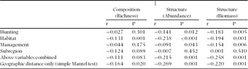
When partial Mantel tests were used to control for geographic position, subregion was no longer a significant predictor of community structure (Table 4). The negligible differences between these results and those of the individual ANOSIM tests indicate that the effects of forest type and hunting pressure on community structure were not confounded by geography. The significant relationship between inter-site distance and levels of community similarity for both abundance and biomass indicates that community structure among nearby sites was more similar than that among sites farther apart, even at this landscape scale.
Partial Mantel test results showing relationships between primate community composition and structure and environmental variables, controlling for the effect of geographic distance among survey sites. Community composition is based on similarity in species occupancy, while structure is based on similarity in both numerical abundance and biomass. r = Pearson correlation. Hunting pressure = None, Light, Heavy. Habitat = Percentage of terra firme forest at site. Management category = Strict protection, Restricted use, Unrestricted (direct) use. Subregion = Manu, Amigos, Piedras, North-MDD, Tambopata.

DISCUSSION
By intensively sampling a single major watershed of south-western Amazonia, this study revealed significant meso-scale biotic heterogeneity within an arboreal mammal taxon that was largely independent of species turnover. Despite the relatively short distances among sites, at least at a pan-Amazonian scale, species richness varied by a factor of two, species assemblage similarity by a factor of four, and aggregate biomass by a factor of ~45. These findings contradict our hypothesis that primate communities remain constant despite meso-scale variation in habitat structure and resource availability.
The variable primate community structure across MDD appears to be due to large-scale species patchiness, rather than actual replacements, even for some common species. The non-linear patterns of primate species occupancy observed in MDD agree with findings by Emmons (Reference EMMONS1984) of minimal turnover among mammalian genera across Amazonia, together with a tendency for consistently rare species to drop out at less favourable (usually nutrient-poor) sites. They were also consistent with floristic evidence on both trees and understorey plants of western Amazonia, the distributions of which have been shown to vary due to changes in microhabitats, such as edaphic gradients, within a broad forest type (i.e. unflooded terra firme forest, Phillips et al. Reference PHILLIPS, VARGAS, MONTEAGUDO, CRUZ, ZANS, SANCHEZ, YLI-HALLA and ROSE2003, Tuomisto et al. Reference TUOMISTO, RUOKOLAINEN, KALLIOLA, LINNA, DANJOY and RODRIGUEZ1995). The inclusion in the analysis of extreme specialists of minor habitat types, such as pygmy marmoset (Peres Reference PERES1993) and Goeldi's marmoset (Porter Reference PORTER2006), might have further amplified fine-scale variation in community composition and structure, but these species are rarely detected during censuses in the predominant forest matrix of western Amazonian forests, even at sites where they presumably occur (C.A. Peres, unpubl. data).
Environmental factors
The mechanisms behind the spatial heterogeneity observed in MDD are not yet known. The lack of support for density compensation seen within the hunted primate communities suggests that biogeographic and environmental factors, rather than interference or exploitative competition, drive community structure. In fact, each of the environmental variables we examined appeared to contribute to some component of this heterogeneity, yet none was an outstanding contributor. For example, the Madre de Dios River and its large tributary, the Inambari River, appear to serve as a barrier to dispersal for three rarer species (woolly monkey, bald-faced saki and emperor tamarin; Ayres & Clutton-Brock Reference AYRES and CLUTTON-BROCK1992, Palminteri et al. Reference PALMINTERI, POWELL, ENDO, KIRKBY, YU and PERES2009), decreasing species richness south of the river, yet the inconsistent distribution of several species among sites north of these rivers remains puzzling.
Consistent with findings elsewhere that the spatial organization of primate communities is partly shaped by habitat heterogeneity resulting from variable inundation regimes (Ayres Reference AYRES1986, Haugaasen & Peres Reference HAUGAASEN and PERES2005b, Peres Reference PERES1997), terra firme forest sites in MDD supported a higher mean number of primate species than adjacent floodplain forest. These differences were less pronounced than those reported for central Amazonia, as aggregate abundance, biomass and community structure did not differ significantly between these habitats. Flood pulses in MDD are typically supra-annual and short-lived (Prance Reference PRANCE1979, Thieme et al. Reference THIEME, LEHNER, ABELL, HAMILTON, KELLNDORFER, POWELL and RIVEROS2007), in contrast to the multiple-month seasonal flooding in the central Amazon. The western Amazon's shorter and less-frequent flooding regimes and generally more nutrient-rich soils (Peres Reference PERES, Schnitzer and Carson2008, Phillips et al. Reference PHILLIPS, ROSE, MONTEAGUDO and VARGAS2006, Terborgh & Andresen Reference TERBORGH and ANDRESEN1998) should produce smaller differences in both primary productivity and, consequently, an intermediate herbivore/frugivore community structure between terra firme and floodplain forests (Peres Reference PERES, Eisenberg and Redford1999b). The primate communities in mature floodplain forests of MDD are, in fact, more diverse than those of seasonally flooded forest (várzea) sites farther east (Haugaasen & Peres Reference HAUGAASEN and PERES2005a, Peres Reference PERES1997), yet their high biomass levels are similar (Endo et al. Reference ENDO, PERES, SALAS, MORI, SANCHEZ-VEGA, SHEPARD, PACHECO and YU2010).
Inter-site similarity in community abundance and biomass correlated most strongly with subregion (ANOSIM). Subregions represented four sub-basins and the main MDD channel, thereby capturing potential differences in local edaphic conditions (Salo et al. Reference SALO, KALLIOLA, HÄKKINEN, MÄKINEN, NIEMELÄ, PUHAKKA and COLEY1986) and floristic composition (Kalliola et al. Reference KALLIOLA, LINNA, PUHAKKA, SALO and RÄSÄNEN1993). For example, Kalliola et al. (Reference KALLIOLA, LINNA, PUHAKKA, SALO and RÄSÄNEN1993) reported that floodplain soils in the Tambopata river basin were highly weathered and more acidic than those of floodplain sites either on the mainstem MDD River or in the Manu River basin. Corresponding successional vegetation at the Tambopata site was also different from the other two sites. Similarly, Foster (Reference FOSTER and Gentry1990) proposed that the ‘conspicuous’ abundance of tree species bearing mammal-dispersed fruits might underlie the relatively high density of primates and other mammals at Cocha Cashu, Manu (Site 5). Major soil-related floristic differences have also been observed among western Amazonian terra firme forests (Ruokolainen et al. Reference RUOKOLAINEN, LINNA and TUOMISTO1997), and age of terra firme soils (Räsänen et al. Reference RÄSÄNEN, SALO, JUNGNER and ROMERO PITTMAN1990) was found to be a key driver of variation in tree species composition in MDD (Phillips et al. Reference PHILLIPS, VARGAS, MONTEAGUDO, CRUZ, ZANS, SANCHEZ, YLI-HALLA and ROSE2003).
Nevertheless, the importance of subregion and other drivers of primate species composition, abundance and biomass in the MDD basin was confounded by the effects of geographic location, which appeared to be an underlying key predictor of primate community similarity. The importance of geographic location at a fine scale reflects that of broad-scale patterns of primate community dissimilarity recorded across South America as a function of geographic distance (Peres & Janson Reference PERES, JANSON, Fleagle, Janson and Reed1999). Consequently, both local environmental variability and geographic distance appear to influence meso-scale patterns of primate community heterogeneity in MDD, as noted for other taxa (Phillips et al. Reference PHILLIPS, VARGAS, MONTEAGUDO, CRUZ, ZANS, SANCHEZ, YLI-HALLA and ROSE2003, Vormisto et al. Reference VORMISTO, SVENNING, HALL and BALSLEV2004).
The BIO-ENV and partial Mantel test results indicated that a combination of environmental factors, rather than any one factor, drives the regional patterns of primate community structure (Table 4). The 18-fold difference in biomass among non-hunted sites illustrates considerable natural heterogeneity independent of hunting pressure. Such spatial heterogeneity in distribution patterns of a relatively generalist and widely distributed vertebrate taxon like primates in the largely intact south-western Amazon forests implies that community heterogeneity will be even greater among more species-rich tropical forest taxa, as well as in regions of higher habitat diversity.
Anthropogenic factors
Consistent with other vertebrate studies (Freese et al. Reference FREESE, HELTNE, CASTRO and WHITESIDES1982, Peres & Palacios Reference PERES and PALACIOS2007), primate biomass in MDD was higher in non-hunted sites than in either lightly or heavily hunted sites. In both MDD and elsewhere in the western Amazon (Bennett et al. Reference BENNETT, LEONARD and CARTNER2001, Freese et al. Reference FREESE, HELTNE, CASTRO and WHITESIDES1982, Heymann et al. Reference HEYMANN, ENCARNACIÓN and CANAQUIN2002, Terborgh et al. Reference TERBORGH, NUÑEZ-ITURRI, PITMAN, CORNEJO, ALVAREZ, SWAMY, PRINGLE and PAINE2008), large-bodied primates bear the brunt of the effect of hunting pressure. In MDD, this effect was observed both for the woolly monkey, which was restricted to Manu NP, and for the ubiquitous spider and howler monkeys. These latter two prey species are widespread in MDD (Levi et al. Reference LEVI, SHEPARD, OHL-SCHACHERER, PERES and YU2009, Ohl-Schacherer et al. Reference OHL-SCHACHERER, SHEPARD, KAPLAN, PERES, LEVI and YU2007) and were recorded in each of our hunting categories but at lower levels of abundance and biomass in hunted sites.
The greater dissimilarity among primate assemblages at hunted sites suggests that primate biomass collapse induced by hunting paradoxically results in greater heterogeneity in community structure by selectively reducing the abundance of common and large-bodied primates to levels unrecorded in non-hunted sites (Figure 3). For example, while non-hunted Manu sites support uniquely high primate biomass and numbers of large-bodied species, the hunted Manu sites along the MDD River, Pusanga (Site 9) and Boca Manu (Site 11), lacked both spider and woolly monkeys, and they supported very low abundances of howler monkey and white-fronted capuchin (Cebus albifrons), two other hunted species. The ‘novel’ assemblages created by these changes in abundance of the most common, large-bodied species resembled those at hunted sites in North-MDD and Tambopata (Sites 26–27, 34–37) more closely than those of non-hunted Manu sites (Figure 3). Likewise, primate assemblages at the three non-hunted sites in the Tambopata subregion were remarkably similar to each other, while those of the hunted Tambopata sites downstream differed not only from the non-hunted sites but also from each other. Only one of 15 non-hunted sites, Limonal (Site 10), lacked both of the two largest-bodied species. The absence of spider monkeys, combined with the presence of the patchily distributed emperor tamarin, rendered this community an outlier (Figure 3). In sum, hunting-induced population declines in otherwise abundant, large-bodied species, combined with the patchy regional distributions of certain less-hunted species (bald-faced saki, emperor tamarin), may have resulted in community signatures previously unknown in the region.
Our results support the key role of strictly protected areas in maintaining primate assemblage integrity, especially for large-bodied species, the disappearance of which has been shown to affect ecological processes, such as seed dispersal and associated tree recruitment, both in MDD (Nuñez-Iturri & Howe Reference NUÑEZ-ITURRI and HOWE2007, Terborgh et al. Reference TERBORGH, NUÑEZ-ITURRI, PITMAN, CORNEJO, ALVAREZ, SWAMY, PRINGLE and PAINE2008) and elsewhere (Chapman & Onderdonk Reference CHAPMAN and ONDERDONK1998, Holbrook & Loiselle Reference HOLBROOK and LOISELLE2009). While land management was highly correlated with hunting pressure (and therefore excluded from our abundance and biomass models), when analysed separately, both aggregate abundance and biomass were significantly higher in sites with active conservation management than in those without. Moreover, although we found no significant relationship between survey effort and species richness, total abundance or total biomass for the 37 sites included in our analyses, separate ANOVAs restricted to only 25 sites with at least 48 km of census effort showed that, in addition to abundance and biomass, species richness also differed significantly among levels of hunting pressure and protection.
Primate communities at the edge of Manu NP differed from those in the park's interior. Within the park, large populations of primates, as well as other endangered vertebrates, occur at both non-hunted sites and those that are hunted by small, localized indigenous populations (Emmons Reference EMMONS1984, Endo et al. Reference ENDO, PERES, SALAS, MORI, SANCHEZ-VEGA, SHEPARD, PACHECO and YU2010, Terborgh Reference TERBORGH1983). The sizeable populations of large-bodied primates surrounding the hunted catchments may be masking the local impact of hunting (Ohl-Schacherer et al. Reference OHL-SCHACHERER, SHEPARD, KAPLAN, PERES, LEVI and YU2007). Immigration from source populations precludes local extinction of some species in at least one of these sites (Tayakome, Site 2, Figure 1) and maintains population densities that, while lower than those at non-hunted Manu sites (Appendix 1), were higher than at unprotected sites throughout the rest of MDD. On the other hand, any animals hunted at sites 9 or even 10, located within but at the edge of the park, may have experienced less recolonization from neighbouring populations, as their community structure was consistently different from those in the park interior.
Combining these results with our assessment of species richness illustrates that while primate communities in MDD are still largely intact, hunting pressure has begun to degrade them, particularly at sites near human populations (Sites 9, 11, 34–37, Figure 1). The MDD region is currently more than 90% forested and over 30% protected (MINAM 2010). The presence of substantial source populations of primates in the large protected areas and the relatively intact forest currently surrounding most of our unprotected sites has likely mitigated the impact of hunting pressure compared with other Amazonian regions. Spider monkeys, for example, occurred at 78% of our sites but were not recorded at most lowland rain-forest sites surveyed in north-eastern Peru (Bennett et al. Reference BENNETT, LEONARD and CARTNER2001, Freese et al. Reference FREESE, HELTNE, CASTRO and WHITESIDES1982, Heymann et al. Reference HEYMANN, ENCARNACIÓN and CANAQUIN2002), northern Bolivia (Christen & Geissmann Reference CHRISTEN and GEISSMANN1994) and south-western Brazilian Amazonia (Peres Reference PERES1990), absences that these authors attributed to hunting pressure.
Nevertheless, the currently high annual deforestation rate (~2%, G. Asner pers. comm.) along the region's infrastructure-development corridor is expected to increase due to the newly upgraded Inter-Oceanic Highway running through the centre of MDD (Figure 1). The projected expansion of the human population resulting from the paving of this road threatens to significantly increase hunting and forest fragmentation (Dourojeanni et al. Reference DOUROJEANNI, BARANDIARÁN and DOUROJEANNI2009), reducing the possibility of recolonization by surrounding source populations of primates and other animals. Intervention focused on maintaining connectivity among faunally intact forest sites across MDD would help to stabilize forest retention and integrity across the region's development corridor. A major regional initiative, including a set of policies regarding development along the road, is urgently needed to prevent the deterioration of one of the largest single blocks of protected habitat in the Amazon basin.
ACKNOWLEDGEMENTS
These studies were funded by The Gordon and Betty Moore Foundation, National Geographic Society's Committee for Research and Exploration, the Leverhulme Trust, National Geographic, and Pro-Manu. We thank the Peruvian Natural Resource Agency (INRENA) and the Matsigenka community for permission to work in Manu National Park and Tambopata National Reserve and the Asociación para la Conservación de la Cuenca Amazónica (ACCA) and Emma Tatum-Hume for permission to work at the Los Amigos and Las Piedras Biodiversity Stations, respectively. We thank the World Wildlife Fund and our teams of field assistants and numerous volunteers for their help in collecting transect data. The comments from Nicole Gross-Camp and two anonymous reviewers greatly improved the manuscript.
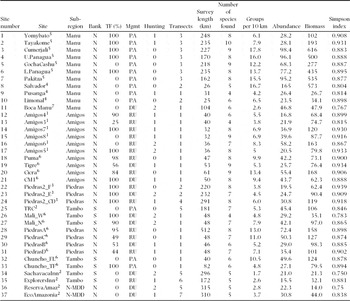
Profile of 37 survey sites (ordered and numbered from west to east, Figure 1) considered in this study: subregion, bank of the Madre de Dios River, per cent terra firme (TF) forest, management regime (Mgmt), level of hunting pressure, number of transects, survey effort (km), number of species sampled (analysed species only), mean number of groups per 10 km walked, aggregate abundance (individuals per 10 km walked), aggregate biomass (kg per 10 km walked), and Simpson diversity index (1-λ'). N/S = North or South of Madre de Dios River; PA = Protected Area, RU = Restricted Use – e.g. tourism, research, non-timber forest products, DU = Direct Use – e.g. buffer zone, logging concession; 0 = No hunting, 1 = Light hunting, 2 = Heavy hunting. Numbers in Site column correspond to contributing datasets: 1 = Kirkby & Padilla (Reference KIRKBY and PADILLA1998); 2 = Kirkby et al. (Reference KIRKBY, DOAN, LLOYD, CORNEJO, ARIZABAL and PALOMINO2000); 3 = Schulte-Herbrüggen & Rossiter unpubl. data; 4 = Kirkby (Reference KIRKBY2004); 5 = Endo et al. (Reference ENDO, PERES, SALAS, MORI, SANCHEZ-VEGA, SHEPARD, PACHECO and YU2010); 6 = S. Palminteri, this study; 7 = Nuñez-Iturri (Reference NUñEZ-ITURRI2007).