Introduction
Archaeological research regarding the earliest occupation in Antarctica has been conducted for the last three decades in the South Shetland Islands (SSI) (e.g. Pearson, Reference Pearson2018; Pearson & Stehberg, Reference Pearson and Stehberg2006; Pearson, Stehberg, Zarankin, Senatore, & Gatica, Reference Pearson, Stehberg, Zarankin, Senatore and Gatica2008; Senatore, Reference Senatore and Headland2018a; Senatore & Zarankin, Reference Senatore, Zarankin, Zarankin and Acuto1999; Stehberg, Reference Stehberg1983, Reference Stehberg2003; Stehberg & Cabeza, Reference Stehberg and Cabeza1984; Zarankin & Senatore, Reference Zarankin and Senatore1996, Reference Zarankin and Senatore1999, Reference Zarankin and Senatore2000, Reference Zarankin and Senatore2005, Reference Zarankin and Senatore2007; Zarankin et al., Reference Zarankin, Hissa, Salerno, Froner, Radicchi, Resende de Assis and Batista2011), and the conservation and management of these sites has become a matter of concern for scientific teams (e.g. Pearson, Stehberg, Zarankin, Senatore, & Gatica, Reference Pearson, Stehberg, Zarankin, Senatore and Gatica2010; Senatore Reference Senatore2018b; Senatore & Zarankin, 2011, Reference Senatore and Zarankin2012; Stehberg, Reference Stehberg, Barr and Chaplin2004; Stehberg, Pearson, Zarankin, Senatore, & Gatica, Reference Stehberg, Pearson, Zarankin, Senatore, Gatica, Barr and Chaplin2008). The archaeologists stated that their conservation is essential for the research about the human past in Antarctica and their heritage values are essential components of the research process. Conserved sites and objects also offer an opportunity to narrate the past, and tourism activities related to these 19th-century sites could contribute to engage visitors with the stories of sealers in the Antarctica. However, no specific actions have been undertaken yet under the Antarctic Treaty System (ATS) in order to ensure effective conservation and management of these sites or to enhance their visibility and interpretation for visitors.
In Antarctica, conservation awareness at historic sites has focused mainly on well-known huts representative of the Heroic Era of Antarctic Exploration (Pearson, Reference Pearson, Barr and Chaplin2011). The initial projects emphasised hut restoration, making the structures accessible to visitors (Harrowfield, Reference Harrowfield2005, p. 10). Since the 1960s, most of the conservation actions and management plans have been successfully implemented at specific and unique historical buildings, from a site-focused perspective (e.g. Harrowfield, Reference Harrowfield1991; Ledingham, Reference Ledingham1979) or a local perspective (e.g. Ashley & Mackay, Reference Ashley, Mackay, Barr and Chaplin2004). Thus, many of them have been opened to visitors (e.g. Hughes, Reference Hughes1992, Reference Hughes1994; Hughes & Davis, Reference Hughes, Davis, Jones and Johnston1995; Stonehouse & Snyder, Reference Stonehouse and Snyder2010; Watson, Reference Watson, Barr and Chaplin2011).
In this paper, we propose that identifying patterns of tourism activity in the SSI could help protect these sites and engage visitors with the early history of Antarctica. Focusing on tourism activities, this study contributes to the discussion on conservation challenges of historical sites, expanding the initial site-focused approaches and emphasising on the sealing sites along the SSI coast from a regional perspective. In this context, the studies of tourism visitation patterns that have expanded initial site-focused approaches in the Antarctic Peninsula (AP) are the most useful tools for understanding the current situation of the sites in relation to tourism practices in the SSI (e.g. Bender, Crosbie, & Lynch, Reference Bender, Crosbie and Lynch2016; Lynch, Crosbie, Fagan, & Naveen, Reference Lynch, Crosbie, Fagan and Naveen2010). Specifically, we are interested in identifying the locations wherein tourism occurs; understanding long-term trends of visitation; and building spatially explicit models for tourism activities that would benefit future decision-making on protecting, managing, and enhancing the interpretation of sealing sites for visitors.
In the next section, we first offer a brief overview of the archaeological research on the earliest occupation in Antarctica conducted in the last three decades, showing why future management plans of the oldest occupations of Antarctica will have to consider crucial aspects of archaeological phenomenon such as the region-wide dispersion of archaeological sites along the SSI and their vulnerability to human activities based on fragility and low visibility. Second, we focused on the SSI to identify patterns of tourism activity, considering landing point usage trends over time and the frequency of passenger landings, in their temporal and spatial dimensions, for better informed protection measures for archaeological sites from a regional perspective. Finally, we used this information to assess the number and situation of 19th-century archaeological sites located in the vicinity of tourism landing points and set priorities for enhancing the visibility of the sites and the sealing history and defining future conservation plans.
Overview of the archaeological research in the SSI
Historical and archaeological studies about the oldest human occupations in Antarctica and the knowledge derived from these studies as well as sealers’ expeditions to the SSI have had a relatively low impact on Antarctic narratives (Senatore & Zarankin, Reference Senatore, Zarankin, Gnecco and Langebaek2014). Initially, the literature on sealing focused mainly on the first sighting of the SSI and the early sealing seasons ca. 1825 (e.g. Balch, Reference Balch1902; Campbell, Reference Campbell2000; Gould, Reference Gould1941; Martin, Reference Martin1940; Miers, Reference Miers1920; Pyne, Reference Pyne2003; Stackpole, Reference Stackpole1950). In addition, historical studies have helped link the 19th-century sealing industry in Antarctica to broader contexts from economic and social approaches (e.g. Basberg, Reference Basberg2017; Basberg & Headland, Reference Basberg and Headland2008; Berguño Reference Berguño1993a,b; Headland, 1999, Reference Headland and Headland2017; Jones, Reference Jones1981a,b; Maddison, Reference Maddison2014; Richards, Reference Richards2003). Archaeological studies have contributed to widening the scope of the Antarctic history studies, showing the analytical power that material culture studies have in understanding sealers’ everyday life experiences on a local scale and focusing on the relation between sealers’ SSI expeditions and capitalist global expansion (Pearson & Stehberg, Reference Pearson and Stehberg2006; Zarankin & Senatore, 2000, 2005, Reference Zarankin and Senatore2007).
The results of the archaeological research projects developed in the SSI since the 1980s have shown the historical significance, location, chronology, and characteristics of the occupations. Sealing activities were developed in the SSI as part of a comprehensive strategy that contributed to the rapid incorporation of uncharted and unknown places in the Antarctic (Senatore, Reference Senatore and Headland2018a). The sealers employed the regional strategy of exploration and occupation by landing gangs of men along the rocky outcrops to build camps to remain on shore during temporary stays. The experiences of those groups of sealers living and working onshore were the first of their kind in Antarctica. With regard to the impact on the environment, archaeological research has demonstrated that in the early 19th century, economic activities were linked to the exploitation of elephant seals, fur seals, and a combination of both, indicating an opportunistic strategy rather than a specialised strategy focused on a specific resource (Senatore, Reference Senatore and Headland2018a).
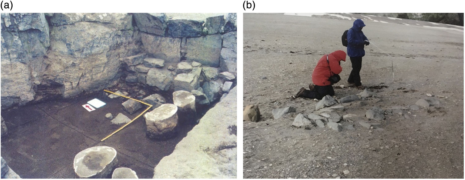
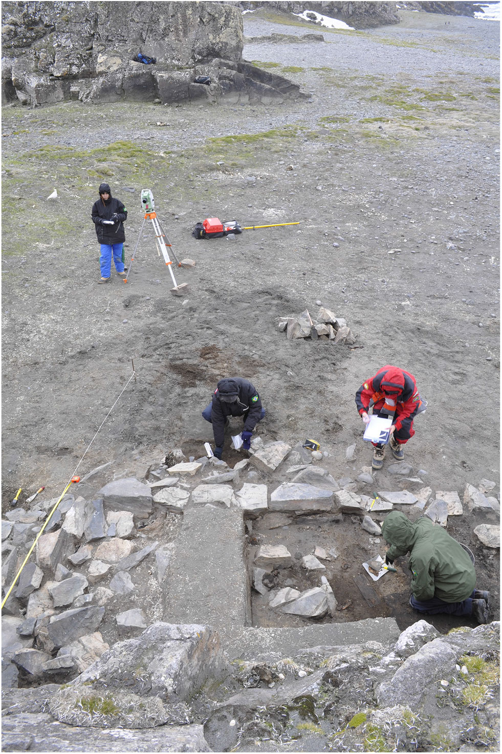
For protection and management purposes, 19th-century sealing sites are better understood as a regional phenomenon limited to the SSI. Archaeological research offers a significant corpus of information on sealing camps, huts, objects, and marine resources exploited during the 19th century in the SSI (e.g. Pearson, Reference Pearson2018; Pearson & Stehberg, 2006, Reference Pearson, Stehberg, Barr and Chaplin2011; Pearson et al., Reference Pearson, Stehberg, Zarankin, Senatore and Gatica2008; Senatore, Reference Senatore and Headland2018a; Senatore & Zarankin, Reference Senatore, Zarankin, Zarankin and Acuto1999; Stehberg, Reference Stehberg2003; Stehberg & Cabeza, Reference Stehberg and Cabeza1987; Stehberg & Lucero, 1985, Reference Stehberg and Lucero1996; Stehberg et al., Reference Stehberg, Pearson, Zarankin, Senatore, Gatica, Barr and Chaplin2008; Zarankin & Senatore, 1996, 2000, 2005, Reference Zarankin and Senatore2007; Zarankin et al., Reference Zarankin, Hissa, Salerno, Froner, Radicchi, Resende de Assis and Batista2011). To date, more than 30 sites have been discovered through fieldwork observations and archaeological surveys along the coasts of the islands, 19 of which have been studied in depth through excavations. An updated open database was built by Laboratório de Estudos Antárticos em Ciências Humanas (LEACH)-Universidade Federal de Minas Gerais that compiled all of the data collected throughout the SSI since the 1980s (http://www.leach.ufmg.br/). The archaeological structures are typically found either isolated or as groups with heterogeneous structures, dimensions, and functions. They were often built to take advantage of the local orography, such as caves, natural shelters, or on the rock face of a cliff or sea stack, only rarely appearing on an open beach. The structures shared some building techniques, such as the raw materials that were used, morphology, or size. Some of them were often simple huts enclosed within low walls made of stones without mortar (Fig. 1). They were roofed using sailcloths made of sealskins and other fabrics and held together by beams made of whale ribs or jaws, wood, or timber. The raw materials used were primarily those available on the beach.
Nineteenth-century sealing sites showing different degrees of visibility in Peninsula Byers, Livingston Island, SSI. (a) View of Playa Sur 1, excavated site with whale vertebrae and mineral charcoal fireplace inside the stonewall hut (Photo M. X. Senatore). (b) View of structure made of rocks placed in an open beach during archaeological fieldworks (Photo M. X. Senatore).

In addition to low visibility of their remains, which makes them nearly imperceptible to visitors without adequate guidance, the sealing sites show the main characteristics of the polar sites, specifically their fragility and simplicity (Barr, Reference Barr, Barr and Chaplin2010). Many of the sites are areas in which objects and stones were distributed along accessible shores. Because these sites consist of local resources, they present low contrast with the SSI landscape. Visibility variations due to snow cover make the sites susceptible to human activities, specifically to the number of visitors, and the circulation path followed onshore.
In general, the ATS offers a repertory of protective mechanism and management tools that could contribute to the protection of sealers’ historical remains (Barr, Reference Barr2018). However, no specific actions focused on the conservation or management of these particular sites have been undertaken yet. Some conceptual and practical limitations to the protection of sealing sites under the ATS have been discussed (Barr, Reference Barr2018; Senatore, Reference Senatore and Headland2018a,b, Reference Senatore2019; Senatore & Zarankin, 2011, Reference Senatore and Zarankin2012; Stehberg et al., Reference Stehberg, Pearson, Zarankin, Senatore, Gatica, Barr and Chaplin2008). The conservation status of the archaeological sites has been evaluated over time, and human and natural factors that influence their deterioration have been identified for specific areas of the SSI (Oliva, Ruiz-Fernández, Zarankin, Casanova-Katny, & Nofre, Reference Oliva, Ruiz-Fernández, Zarankin, Casanova-Katny and Nofre2017; Pearson et al., Reference Pearson, Stehberg, Zarankin, Senatore and Gatica2010).
For the protection and management of the 19th-century sealing sites, the Antarctic Special Protected Areas (ASPAs) are of particular interest. In 2002, the Annex V on Area Protection and Management of the Madrid Protocol came into force and established mechanisms to designate and manage ASPAs based on “outstanding environmental, scientific, historic, aesthetic, or wilderness” values (Art. 3(1)). The largest proportion of known sealing archaeological sites on the SSI are within three ASPAs (ASPA No. 125 Fildes Peninsula in 25 de Mayo/King George Island, ASPA No. 126 Peninsula Byers, and ASPA No. 146 Cape Shireff on Livingston Island). As visitor traffic is regulated in these areas, the sites will never be at risk from the tourism factor. However, the general protection afforded by the ASPA regulations is not enough to protect each site (Barr, Reference Barr2018, p. 8), and researchers still face the challenge of increasing the visibility of the sealers’ sites within the ASPAs. The Committee for Environmental Protection (CEP), which was created to provide advice and formulate recommendations to the parties related to the implementation of the Protocol, has produced guidance material for protecting and managing Antarctic areas visited by tourism. The Site Guidelines for Visitors could also contribute to the protection of the archaeological sites. This tool was not developed specifically with the objective of protecting historic remains. However, it could help enhance the visibility of the sealing archaeological sites. The aim of these guidelines is to provide specific instructions on the conduct of activities at the most frequently visited Antarctic sites. Currently, from the 12 available for the SSI, only one—Yankee Harbour (YH) on Greenwich Island—mentions 19th-century sealers’ remains near the landing point used by tourist boats.
Assessing tourism visitation patterns in the SSI
Tourism studies and trends identified for the AP (Bender et al., Reference Bender, Crosbie and Lynch2016; Lee & Hughes, Reference Lee and Hughes2010; Lynch et al., Reference Lynch, Crosbie, Fagan and Naveen2010) are considered a broader context for understanding the SSI. We investigated the extent to which the patterns and scenarios defined for the AP were represented in the SSI. The islands are included in the itineraries of tourist cruises that visit the AP. Tourism is operated mainly by members of the International Association of Antarctica Tour Operators (IAATO) within the parameters of the ATS. However, there are other ships, specially yachts, that are not belonging to the IAATO that reaching the Antarctic region as well. The SSI themselves are not a destination for commercial tourism, except for the one-day programme for tourists offered by the Chilean company Aerovias DAP, which includes walks along the coast of the Fildes Peninsula (Braun, Mustafa, Nordt, Pfeiffer, & Peter, Reference Braun, Mustafa, Nordt, Pfeiffer and Peter2012). Traditional expeditions are operated by cruise vessels that carry between 5 (sailing boats and yachts) and 200 passengers. They include the landing of small passenger groups by using a Zodiac rubber boat, but the number of passengers landing at one time is restricted to 100 by the ATS. For the sector of seaborne trips with landings, the IAATO member operators offer educational programs for visitors to experience and learn about Antarctica.
The analyses in this paper were based on publicly available specific data describing tourism landing activities of the IAATO members in the SSI. These analyses could be conducted on a regional scale based on data about tourism activities that have been collected by the IAATO during the past two decades and are available online. Conducting analyses of tourism visitation patterns on a regional scale, such as in the SSI, could not only enhance management and conservation plans but could also contribute to the identification of specific lines of inquiry and research on human impact and help define approaches to the uncertainties that remain regarding cumulative impact in different areas of the archipelago.
We performed three series of analyses focusing on different aspects of these data. The temporal analyses focused on the temporal trends of tourist activities within the SSI compared to the AP; the spatial analyses evaluated the distribution of landing points among the islands. The spatiotemporal analyses focused on the identification of common temporal patterns of passenger landings across different landing points.
Methods
The analyses were performed using tourism statistics available online, provided by the IAATO for 13 seasons from 2003–2004 to 2015–2016, which include records of site-specific landing by IAATO members. A database, which includes information regarding tourism statistics for these 13 seasons, was created. This database collected the number of tourists and ships that visited the SSI as well as the number of passenger landing points for each season. In addition, for each individual landing point (59 total landing points), the database included the number of passenger landings at each point during each season. The number of tourists who visited the SSI was determined by counting the visitors on board the ships that made at least one landing in the SSI. The information was collected from the IAATO general web page (https://iaato.org/home) and the IAATO statistics page (http://iaato.org/antarctic-peninsula-sites) during 2016. For each landing site within the SSI (59 points), the database also included its geolocation. This information was partly obtained from the limited list of landing sites and geolocations available on the IAATO general web page (for the 18 landing points within the SSI) and from the Scientific Committee on Antarctic Research Composite Gazetteer of Antarctica (https://data.aad.gov.au/aadc/gaz/scar/) (for the 41 remaining landing points).
The temporal analyses focused on the temporal trends of tourist activities within the SSI compared to the AP. In particular, the time series associated with the total number of landing points, passenger landings, ships, and tourists were analysed for the SSI and the AP. Each of these four time series consisted of 13 time points (2003–2004 to 2015–2016). These SSI time series were displayed and compared to the equivalent time series within the entire AP. To investigate the temporal trends, for each target time series, we computed the unique association with each of the other time series together with potential linear global growth factors using a multiple regression model. For example, the total number of landing points was modelled using a linear combination of five factors: a constant term, a linear temporal trend, and three additional factors modelling the association between the total number of landing points and that of landings, ships, and tourists, respectively.
The spatial analyses evaluated the distribution of landing points among the islands. The SSI maritime contours were obtained from the Trinity Peninsula area and the SSI map from “Coastal-change and glaciological map of the Trinity Peninsula area and the SSI, Antarctica: 1843–2000” (Ferrigno et al., Reference Ferrigno, Cook, Foley, Williams, Swithinbank, Fox and … Sievers2006). Landing point geographical coordinates were obtained in detail in the data collection section. In addition, the geographical coordinates of archaeological sites within the SSI were obtained from published research. The geographical coordinates of the landing points and archaeological sites were projected on the map using a grid of 1° latitude by 3° longitude as a reference and using a stereographic polar projection transformation. Additional maps were constructed, displaying the total number of passenger landings within each landing point.
The spatiotemporal analyses focused on the identification of common temporal patterns of passenger landings across different landing points. For this purpose, we used hierarchical clustering (Ward’s linkage, Ward, Reference Ward1963) to identify potential patterns among the landing time series of the 59 SSI landing points. Clustering is a procedure that groups a set of objects in such a way that objects in the same group are more similar than those in other groups. In these analyses, we defined groups of landing points based on the similarity of their landing time series. A logarithmic transformation of the number of landings at each landing site and at each point of time was used to normalise the total number of landings across different sites partially. The optimal number of clusters was determined using a 2% decrease variance threshold (Ward’s criterion). For each cluster of landing points, we constructed a map displaying the location of these landing points, as well as a plot displaying the temporal evolution of the number of landings within members of this cluster. We also evaluated the degree of superposition for each cluster of landing points with the archaeological sites identified from scientific research.
Results: patterns in tourism visitation in the SSI
Temporal patterns in tourism visitation in the SSI
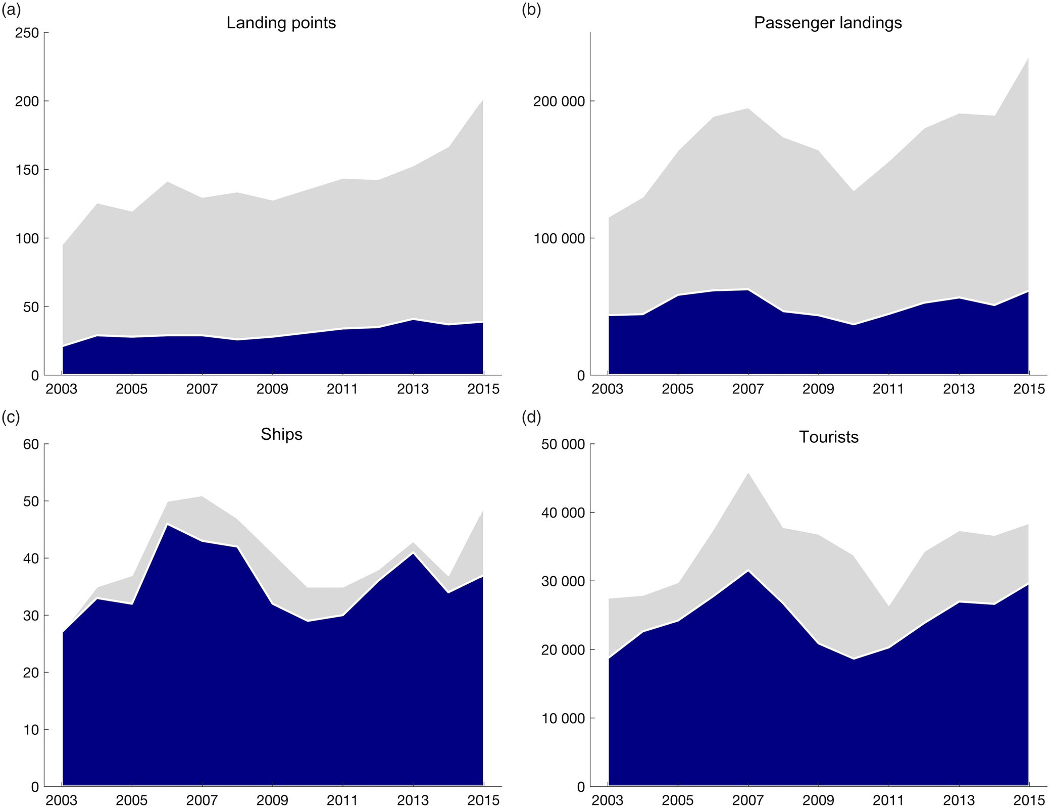
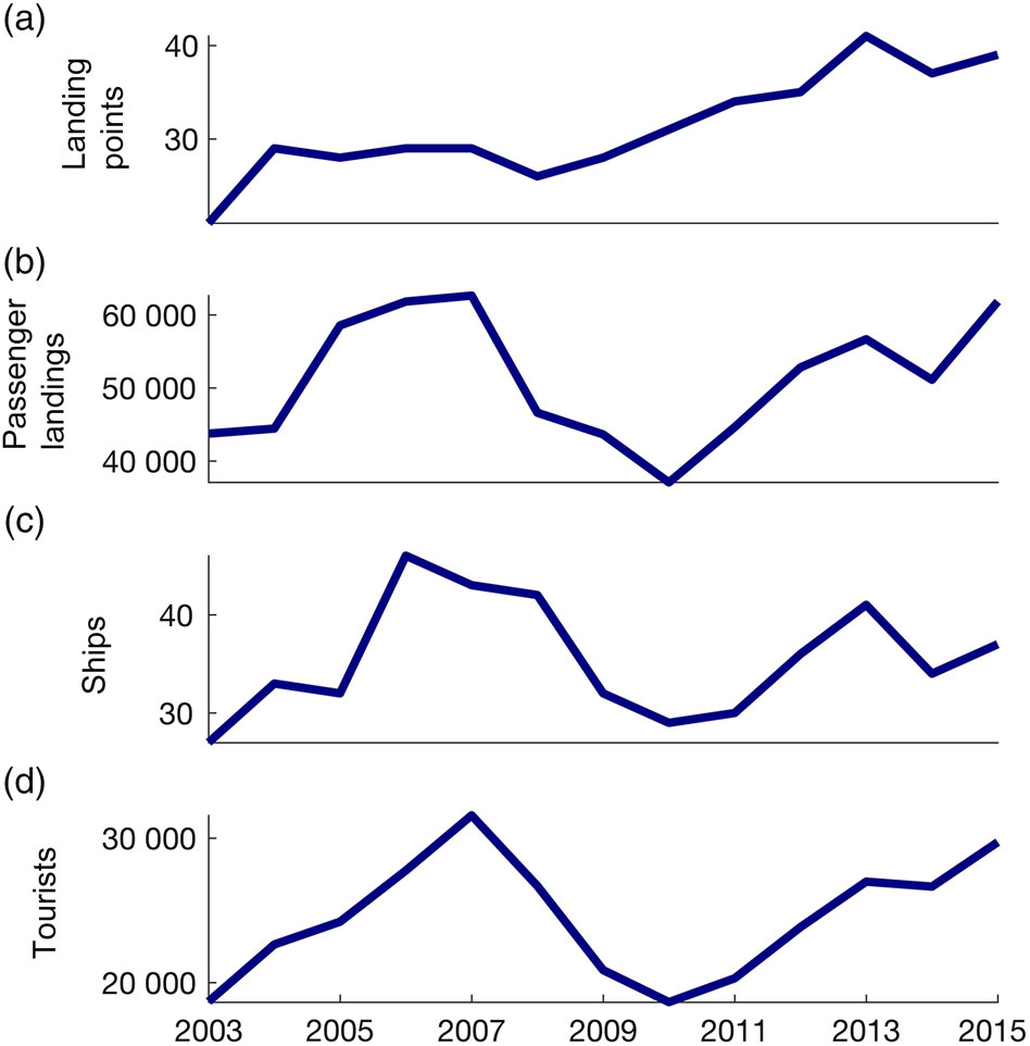
Approximately 88% of the ships going to AP included landings in the SSI (Fig. 2c), and 71% of the AP tourists visited the islands (Fig. 2d). The proportion has remained constant with small variations. Among the landing points in the AP, 22% were within the SSI (Fig. 2a) and 30% of the total passenger landings were on the islands (Fig. 2b). In the last three seasons, an increase in the number of landing points was observed for the AP (T(11) = 5.44, p < 0.001) as well as for the SSI (T(11) = 6.31, p < 0.001). The number of ships visiting the SSI and the number of tourists who landed were highly correlated (r = 0.84, p < 0.001) (Figs. 3c and 3d); however, the number of landing points was not influenced by these factors (F(2.9) = 0.41, p = 0.67). A linear trend was observed over time for the number of landing points, increasing, on average, one to two points a year with comparatively small additional temporal fluctuations (T(8) = 5.64, p < 0.001) (Fig. 3a). By contrast, the number of ships, tourists, and passenger landings did not show a significant linear increase within the relatively larger temporal fluctuations observed (T(8) < 1.39, p > 0.20) (Figs. 3b–d). From the differences observed in the number of landing points, ships, tourists, and passenger landings, we concluded that the number of tourists could not be considered a major pressure factor for the opening of new landing points in the SSI.
Representation of the variation of (a) landing points, (b) passenger landings, (c) ships, and (d) tourists from 2003–2004 to 2015–2016. The Antarctic Peninsula (grey) and the South Shetland Islands (blue).

Representation of the temporal sequences of (a) landing points, (b) passenger landings, (c) ships, and (d) tourists from 2003–2004 to 2015–2016 in the South Shetland Islands.

Spatial patterns in tourism visitation in the SSI
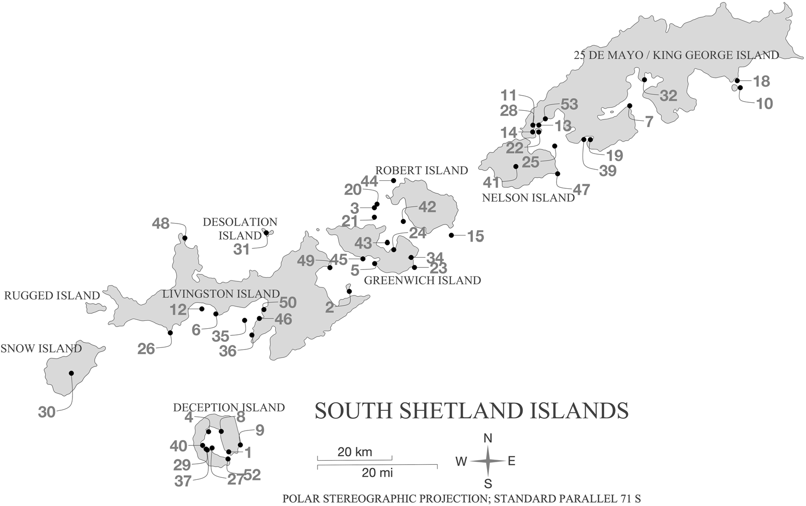
In the SSI, 59 landing points, including 13 scientific stations used by IAATO members, were identified from 2003–2004 to 2015–2016 (Fig. 4). The assessment of the distribution of tourist activities along the SSI showed that 90% of the passenger landings occurred at 13 (22%) landing points. The uneven distribution of tourism already identified for the AP also occurred in the SSI. Lynch et al. (Reference Lynch, Crosbie, Fagan and Naveen2010) and Bender et al. (Reference Bender, Crosbie and Lynch2016) proved that a significant proportion of land-based tour activities in the AP region are concentrated in a small number of places. In 2013–2014, almost 68% of all landings occurred at just 15 sites (Bender et al., Reference Bender, Crosbie and Lynch2016, p. 200).
Distribution and names of the landing points in the South Shetland Islands used by IAATO members from 2003–2004 to 2015–2016. 1 = Whalers Bay; 2 = Half Moon Island; 3 = Aitcho Islands – Barrientos Island; 4 = Telefon Bay; 5 = Yankee Harbour; 6 = Hannah Point; 7 = Arctowski Station; 8 = Pendulum Cove; 9 = Baily Head; 10 = Penguin Island; 11 = Frei Station; 12 = Walker Bay; 13 = Bellingshausen Station; 14 = Great Wall Station; 15 = Robert Point; 16 = Cape Lookout; 17 = Point Wild; 18 = Turret Point; 19 = Jubany; 20 = Aitcho Islands – Other; 21 = Dee Island; 22 = Ardley Island; 23 = Fort Point; 24 = Arturo Prat Station; 25 = Maxwell Bay; 26 = Elephant Point; 27 = Port Foster; 28 = Fildes Station; 29 = Deception Base Research Station; 30 = Snow Island; 31 = Desolation Island; 32 = Ferraz Station; 33 = Cape Valentine; 34 = Hardy Cove; 35 = South Bay; 36 = Sally Rocks; 37 = Gabriel de Castilla Station; 38 = Gibbs Island; 39 = Potter Cove; 40 = Fumarole Bay; 41 = Nelson Island; 42 = English Strait; 43 = Discovery Bay; 44 = Heywood Island; 45 = Triangle Point; 46 = Juan Carlos I Station; 47 = Duthoit Point; 48 = Cape Shirreff; 49 = Edinburgh Hill; 50 = Ohridski (Bulgarian Station); 51 = Walker Point; 52 = Neptunes Bellows; 53 = Artigas Station; 54 = Admiralty Bay; 55 = Deception Island; 56 = Elephant Island; 57 = Fildes Peninsula; 58 = Greenwich Island; 59 = Livingston Island.

Spatiotemporal patterns in tourism visitation in the SSI
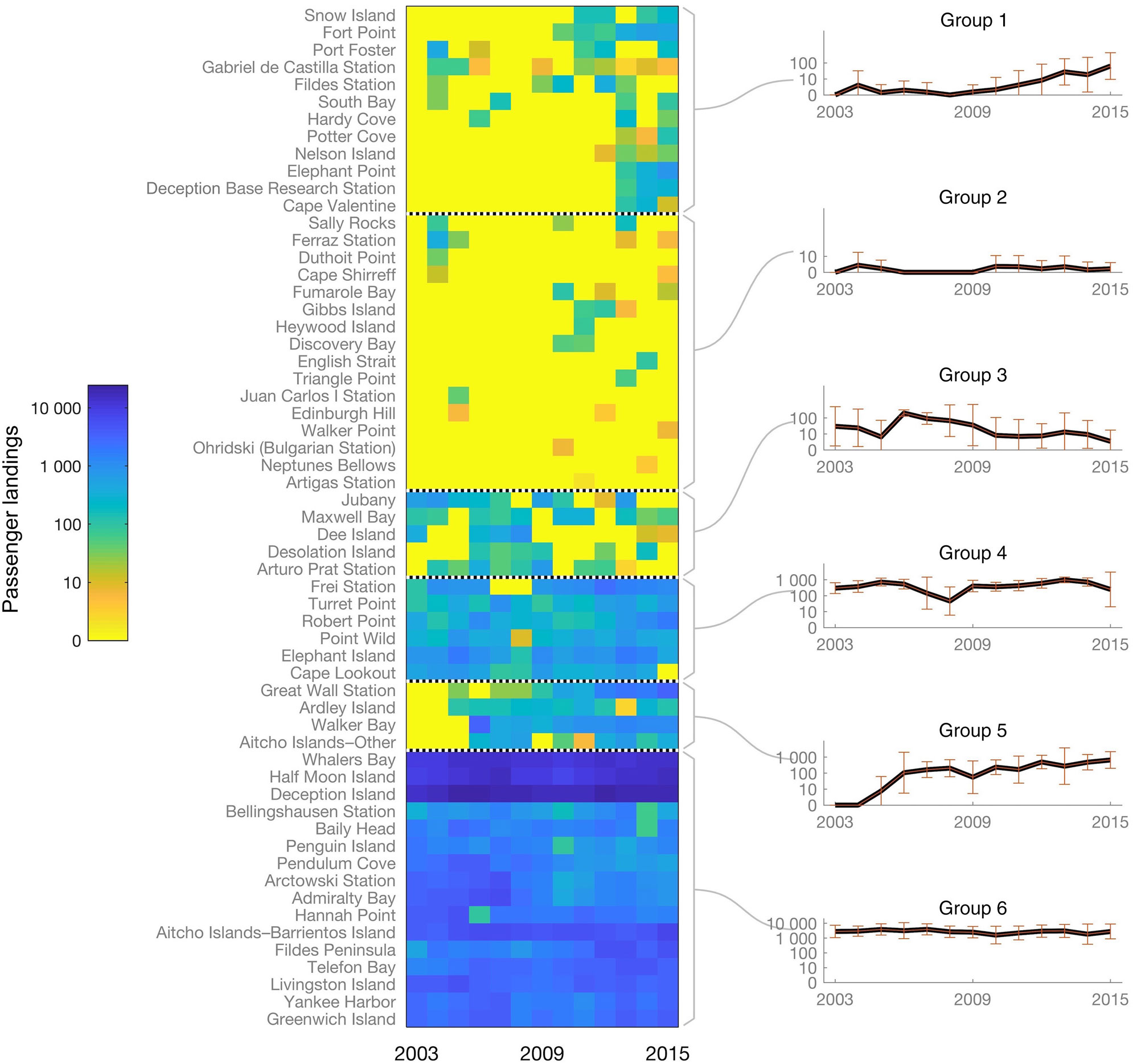
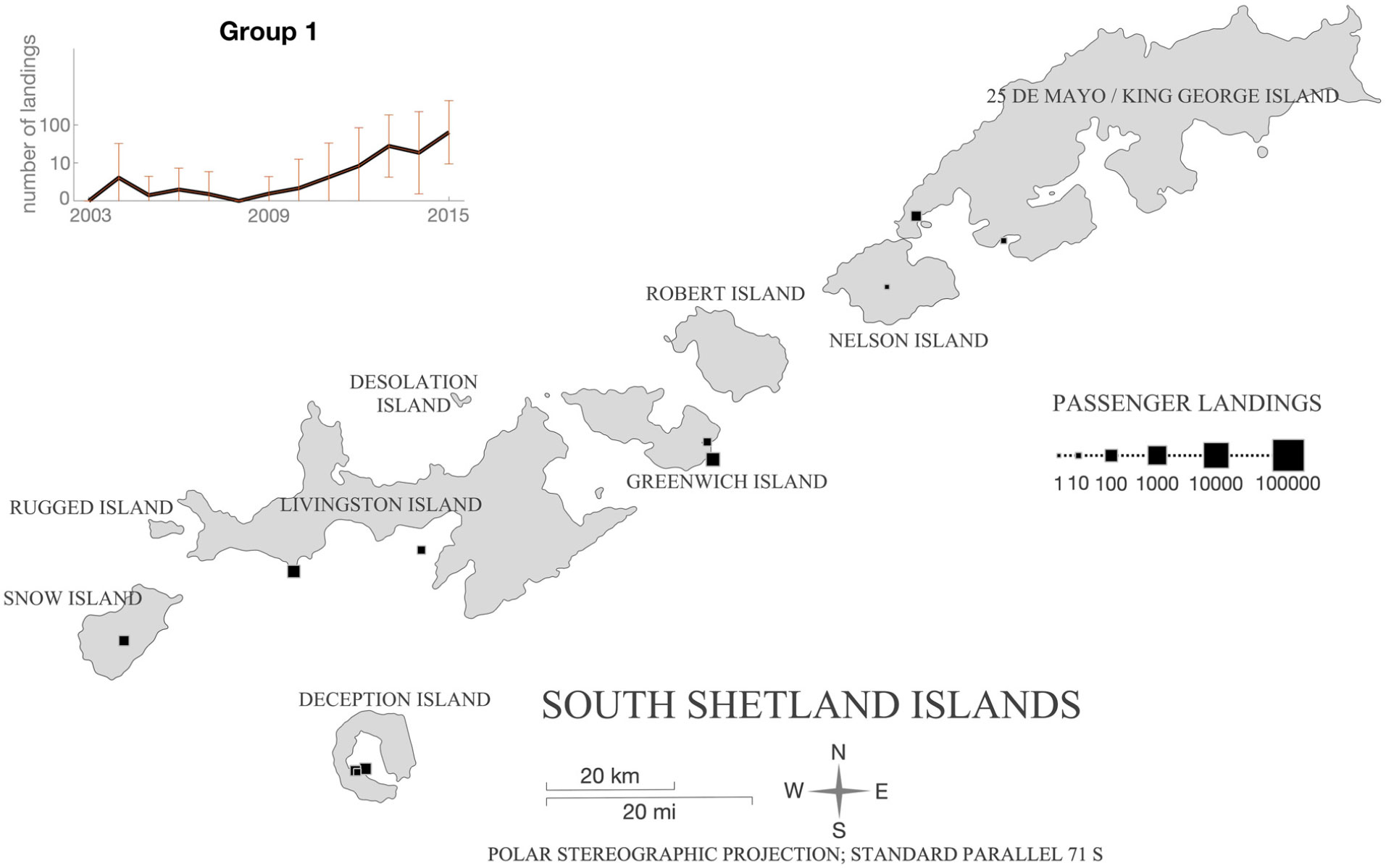
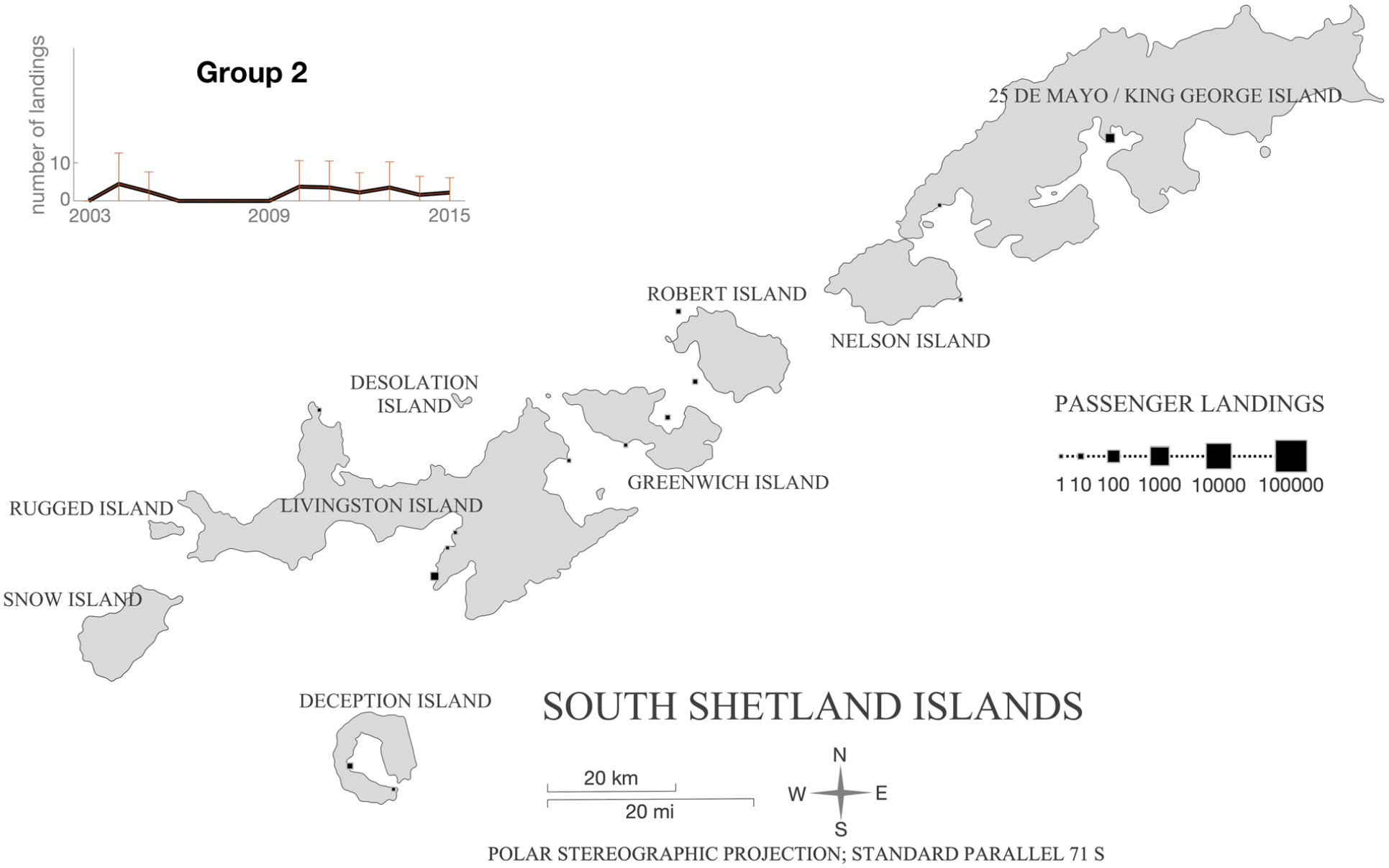
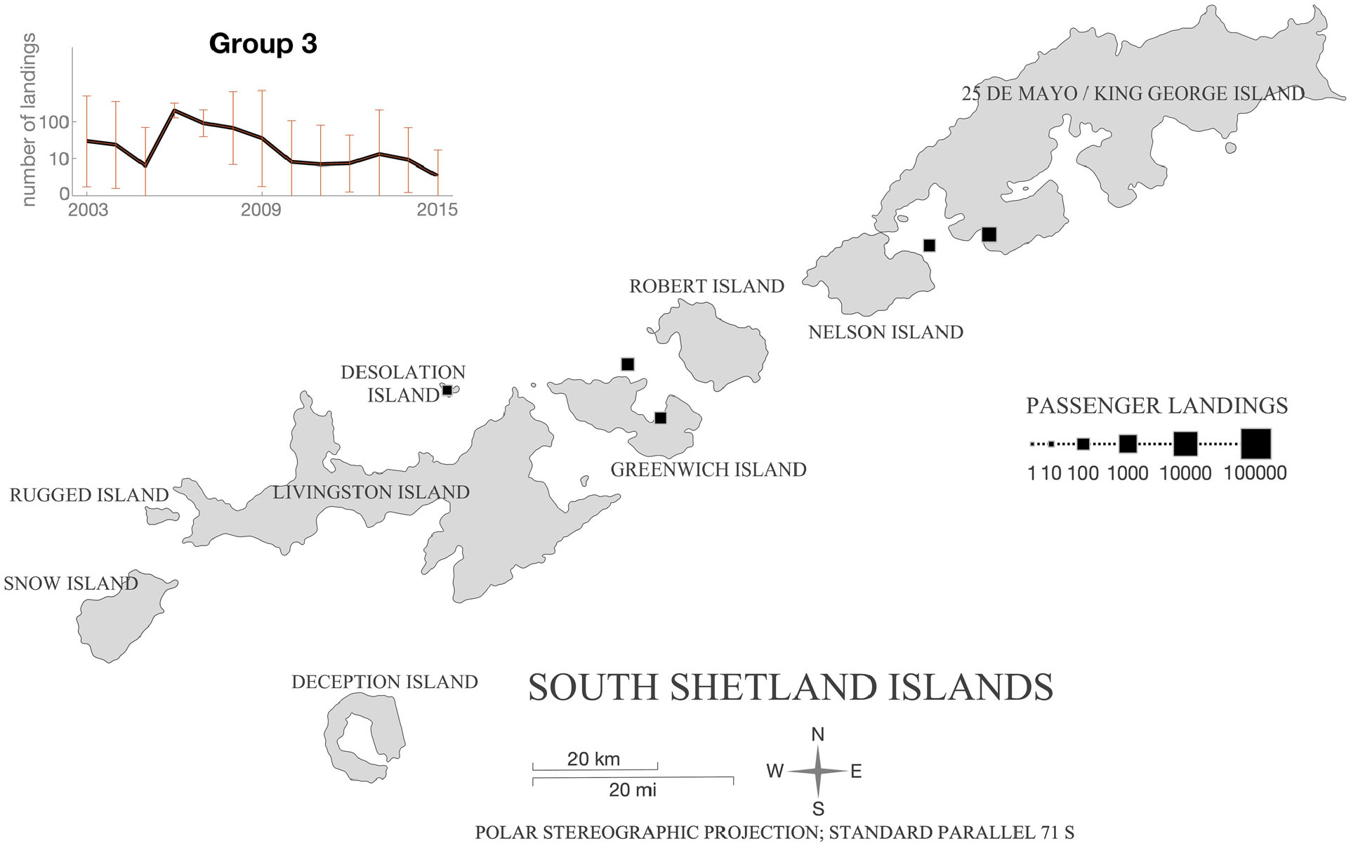
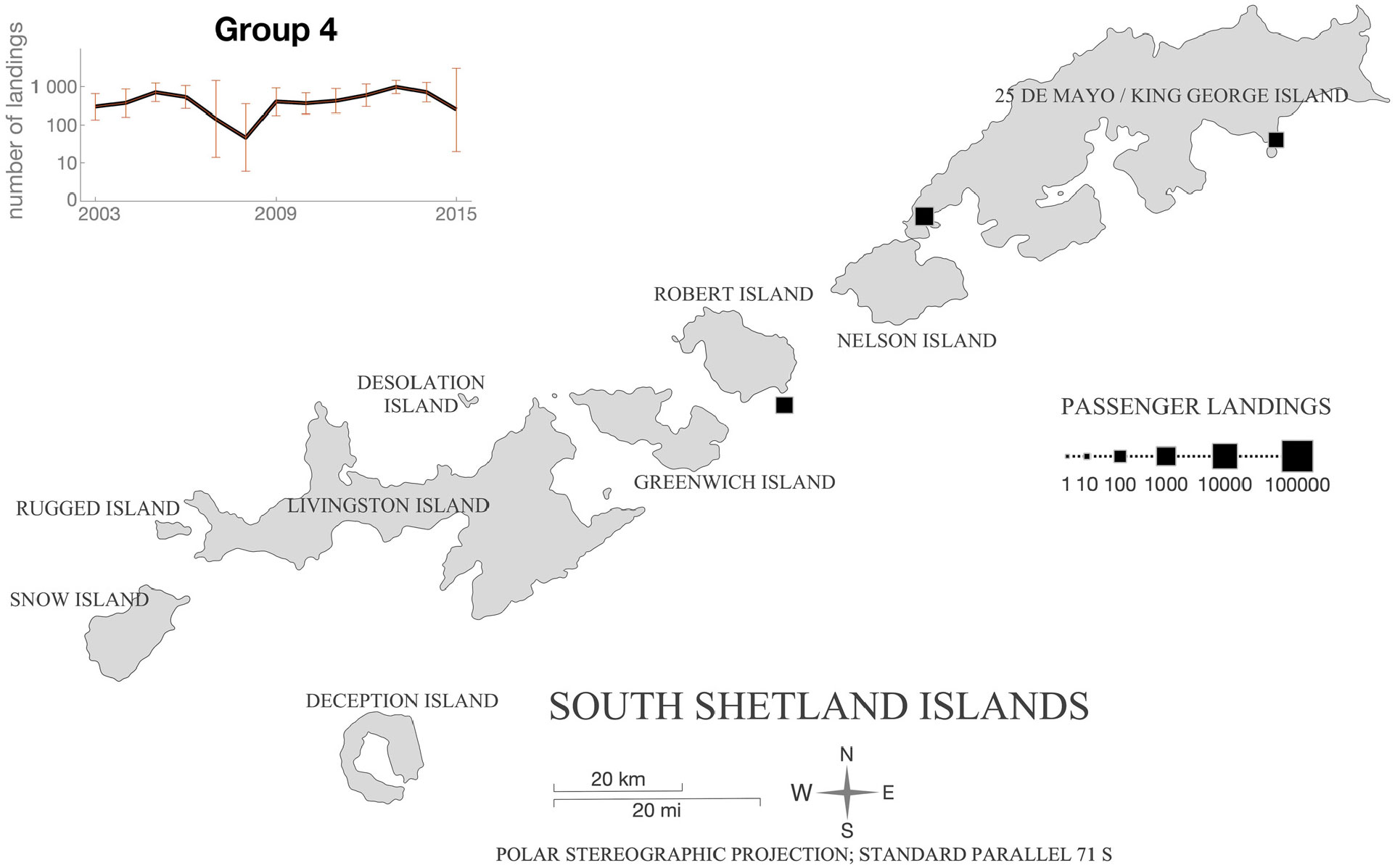
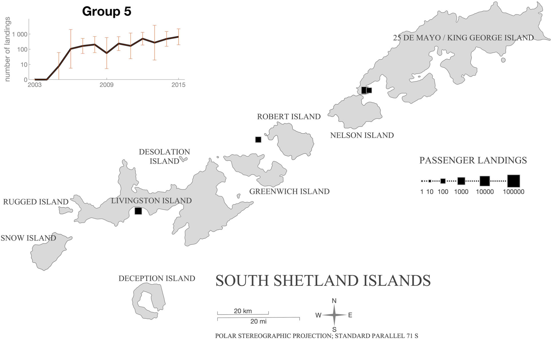
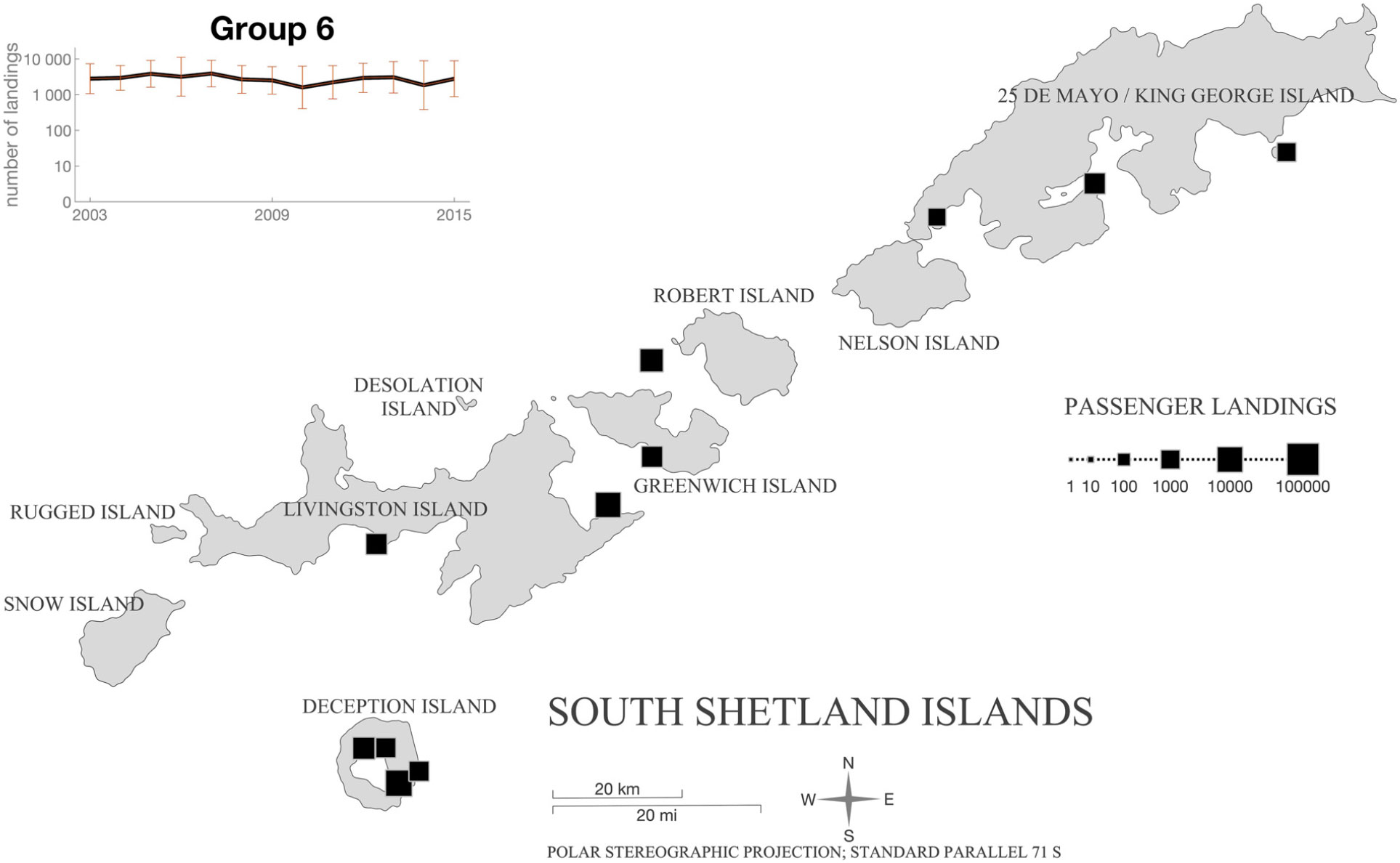
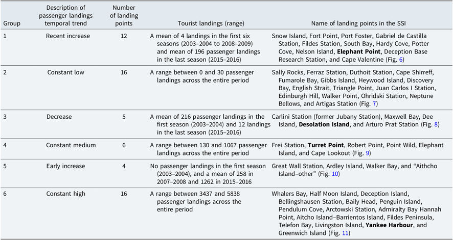
The cluster analysis resulted in the definition of six groups that characterise different patterns of visitation over time (Fig. 5). The groups were characterised according to their number and temporal trends in passenger landings. Group 1 included 12 landing points and showed a recent increase in number of passenger landings, with a mean of 4 landings in the first six seasons (2003–2004 to 2008–2009) and a mean of 196 landings in the last season (2015–2016) (Fig. 6). Group 2 had 16 landing points and showed a constant limited number of passenger landings ranging between 0 and 30 passenger landings across the entire period (Fig. 7). Group 3 had 5 landing points and was characterised by a decreasing number of passenger landings, a mean of 216 landings in the first season (2003–2004) and 12 landings in the last season (2015–2016) (Fig. 8). In Group 4, there were 6 landing points and the temporal trend was constant medium, ranging between 130 and 1067 passenger landings across the entire period (Fig. 9). Group 5 included 4 landing points, and the number of passenger landings showed an early increase from 0 in the first season (2003–2004) to a mean of 258 in 2007–2008 and 1262 in 2015–2016 (Fig. 10). Group 6 presented 16 landing points and maintained a constant and high number of passenger landings over time, ranging between 3437 and 5838 passenger landings across the entire period (Fig. 11).
Representation of the patterns of tourism visitation in the South Shetland Islands over time resulting from cluster analysis.

Group 1 landing point distribution in the South Shetland Islands.

Group 2 landing point distribution in the South Shetland Islands.

Group 3 landing point distribution in the South Shetland Islands.

Group 4 landing point distribution in the South Shetland Islands.

Group 5 landing point distribution in the South Shetland Islands.

Group 6 landing point distribution in the South Shetland Islands.

As presented in Table 1, the groups showed a wide-ranging number of landing points and differed in size, ranging from 4 to 16 landing points. Temporal tendencies varied from increasing, constant, or decreasing trends over time. Two groups showed an increasing trend (Groups 1 and 5) but differed in the magnitude and intensity of growth over time as well as in the timing of the increase. Group 5 showed a comparatively early increase in passenger landings starting around 2005–2006, while Group 1 started to increase later around 2010–2011. Three groups (2, 4, and 6) presented a constant trend differing in the magnitude and intensity of the visitation. Even though these groups exhibited a constant trend of passenger landings, the frequency of visitation presented differences (ranging 0–30 in Group 2; 130–1067 in Group 4, and 3500–6000 in Group 6).
Information of the patterns of tourism visitation in the SSI. Landing point areas near archaeological sites are showed in bold

Archaeological sites and tourism visitation patterns in the SSI
Identifying these six visitation patterns contributes to understanding the vulnerability of specific 19th-century sites located near tourist landing points and should form a basis for setting priorities in the development and implementation of specific site conservation and management strategies. The visitation patterns help identify the potential of specific sites to engage visitors with the stories of 19th-century sealing in Antarctica.
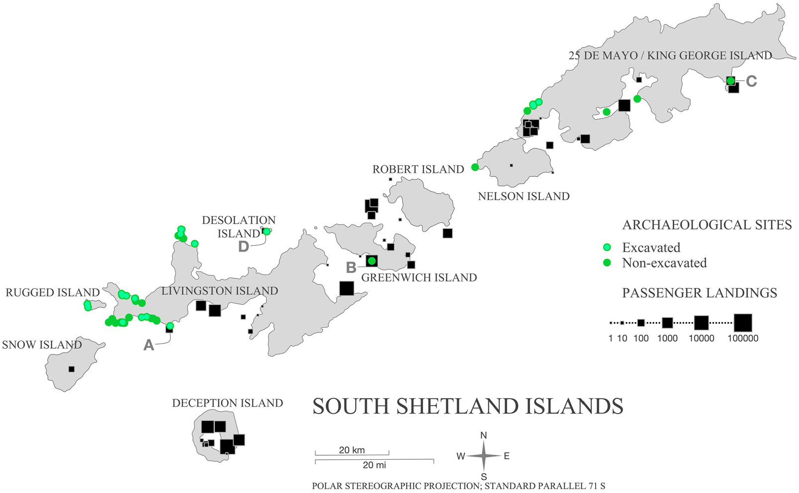
Localisation of the passenger landing points near the archaeological sites was observed in four cases (Fig. 12): (A) Elephant Point on Livingston Island, (B) YH on Greenwich Island, (C) Turret Point (TP) on 25 de Mayo/King George Island, and (D) Desolation Island.
Distribution of landing points showing the cumulative number of passenger landings and the location of 19th-century sealing archaeological sites in the South Shetland Islands.

A. The first case is Elephant Point on Livingston Island (Fig. 13). This landing point belongs to Group 1, which is characterised by a recently increasing trend over time. The archaeologists identified a highly visible assemblage of stonewall structures (sites Punta Elefante (PE1), PE2, PE3, PE4, Punta Elefante X (PEX1)). The site PE2 is the most well preserved of the SSI (A. Zarankin personal communication, 1 March 2012). They were partially excavated, establishing their functionality and use by sealers in the 19th century (Oliva et al., Reference Oliva, Ruiz-Fernández, Zarankin, Casanova-Katny and Nofre2017).
Fig. 13.Nineteenth-century sealers’ remains in the vicinities of Elephant Point tourism landing points. View of the PEX1 site during archaeological fieldworks in Elephant Point, Livingston Island (Photo A. Zarankin LEACH).

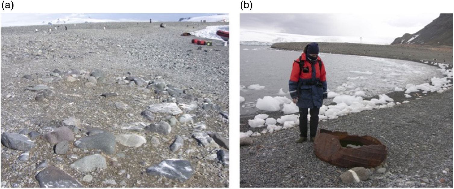
B. The second case is YH on Greenwich Island. This landing point belongs to Group 6, which consistently presented the highest number of landings. Even though it is a highly visited place and the sealers’ remains are mentioned in the Site Guidelines for Visitors, there is not a monitoring plan for assessing the impact on the archaeological site. The archaeological site was first identified in the 1960s (White 1966 in Lewis Smith & Simpson, Reference Lewis Smith and Simpson1987; Pearson & Stehberg, Reference Pearson and Stehberg2006) and surveyed in 2000 (Zarankin & Senatore, Reference Zarankin and Senatore2007). The archaeologist observed one structure formed by lines of stones (site YH) associated with a semi-buried large iron pot, and the remains of material culture and mineral charcoal dispersed on the surface (Fig. 14a). The low visibility of the structure and cultural remains make them imperceptible to visitors without experienced guidance (Senatore & Zarankin, Reference Senatore and Zarankin2012). Yet, it is crucial to consider the scientific relevance of this archaeological site. First, this type of structure has not been very frequently observed by archaeologists in the SSI. Because they have not been excavated, the functionality of these types of structures has not yet been determined. Second, the iron pot in YH (Fig. 14b) is the only one of this kind, identified in situ in the SSI.
Fig. 14.Nineteenth-century sealers’ remains in the vicinities of YH tourism landing point. (a) View of the YH site, structure of rocks placed in open beach (Photo M. X. Senatore). (b) View of the semi-buried iron trypot in YH, Greenwich Island (Photo M. X. Senatore).
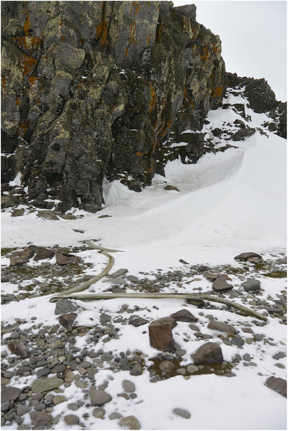
C. The third case is TP on 25 de Mayo/King George Island. The information about the archaeological site (site TP) is limited (M. Pearson personal communication, 1 March 2019). Although it was identified and recorded by archaeologists in the early 1980s, it has not been excavated (Stehberg, Reference Stehberg2003). The first sighting of the site was recorded by geologists in the 1960s and published several years later with a picture and a brief description of the remains (White 1966 in Lewis Smith & Simpson, Reference Lewis Smith and Simpson1987, p. 68). Based on the snow cover, the visibility of the structure varies during the summer, making it imperceptible to visitors (M. Pearson personal communication, 1 March 2019) (Fig. 15). The site is located near the landing point that belongs to Group 4, which is characterised by a constant temporal trend with intermediate range of passenger landings across the entire period. Despite being frequently visited by tourists, the sealers’ remains are not mentioned in the Site Guidelines for Visitors available for this area.
Fig. 15.Nineteenth-century sealers’ remains in the vicinities of TP tourism landing point. View of TP site in Turret Point, 25 de Mayo/King George Island (Photo M. Pearson).
D. The fourth case is Desolation Island, where several archaeological sites were identified and studied near Cora Bay and Blythe Bay (Stehberg, Reference Stehberg2003; Stehberg & Lucero, Reference Stehberg and Lucero1985). Some of them were excavated and studied in depth in the 1990s (site Co2). The structures were characterised by their low visibility and presented different functions and chronology of use from the 19th to the 20th century (Stehberg, Reference Stehberg2003, pp. 109–129). The landing point in the vicinities of the archaeological sites belongs to Group 3, characterised by a decreasing trend over time.


It is possible that similar situations also occurred in other places of the SSI, such as Admiralty Bay–Point Hennequin and Fildes Peninsula on 25 de Mayo/King George Island. However, that could not be confirmed, as the information currently available is not precise regarding the geographical coordinates of the landing points.
Discussion: using tourism visitation patterns for the conservation of the archaeological sites in the SSI
In this paper, we identified long-term trends and spatiotemporal patterns of tourism visitation for the SSI, considering trends of landing points used over time and the frequency of passenger landings; thus, we identified the archaeological sites located near the places used for tourism activities. Over time, there has been a significant increase in landing points used in the AP and in the SSI. On the islands, a linear trend over time was observed for the number of landing points, which constantly increases by one or two points a year on average. During that period, a total of 59 landing points were used.
In this context, we emphasise that even though the data available confirmed that the vicinities of four archaeological sites are being used as landing points by tourism so far, the trends show that the number of landing points in the SSI is increasing and it is inevitable that other sites will be reached through tourism. Therefore, any proposal for the protection and enhancement of the visibility of the sites should be elaborated before other sites are included in cruise itineraries, rather than after they are visited. Information on the ways that unvisited places of the SSI have been incorporated in tourism could forecast the incorporation of new landing points and the potential impact on 19th-century archaeological sites.
In the SSI, we found that tourism during the last decade has been a highly concentrated activity, with 90% of all landings occurring at 13 sites that represent 22% of all the landing points. The spatiotemporal analysis showed that this uneven distribution was more heterogeneous than the concentrated–dispersed spatial visitation patterns could indicate. We defined six different visitation patterns that should contribute to setting priorities in the specific management strategies for the 19th-century archaeological sites. Temporal tendencies varied from increasing, constant, or decreasing trends over time, differing in the magnitude and intensity of the visitation. They could also be interpreted as the current regional scenarios for assessing tourism impact and conservation challenges in the SSI.
Considering specific cases
We identified four cases of archaeological sites located in the vicinities of landing points. First, we identified an increasing visitation trend (Group 1) in an area that is still being researched, as the Elephant Point case showed the archaeological richness and well-preserved sites. Second, we identified constant and highly focalised activity in the YH (Group 6) in an area of potential research interest having Site Guidelines for Visitors. Third, we observed an area that has been continuously and frequently visited (Group 4) in the vicinity of an archaeological site that has not yet been studied and is not mentioned in the Site Guidelines for Visitors. Fourth, we identified an area with a decreasing trend of low-frequency visitation (Group 3) that shows the diversity and richness of archaeological remains studied several years ago.
Considering the visitation patterns, the archaeological sites at higher risk of impact by human activities are located at Elephant Point on Livingston Island, due to their increasing visitation rates, and also at YH on Greenwich Island and TP on 25 de Mayo/King George Island, due to their relatively high and persistent tourist visitation rates. These sites must be prioritised for specific short-term conservation measures, and we recommend immediate action. Even though the sites located on Desolation Island should also be protected, their exposure to risk seems lower than in the other three cases, considering their comparatively lower and declining visitation rates.
In those specific cases, the protection and management proposals could be approached with a local view or site-specific scale considering the best options for each case. Available ATS tools such as the Visitors Site Guidelines could be considered the most useful ones to address the urgency of risk in the short term for those places already visited by tourism. The YH and TP areas have potential to engage visitors with the stories of sealers in Antarctica. Currently, there are guidelines available for all highly concentrated passenger landing points in the SSI, but the information offered about the location and characteristics of sealing sites is neither sufficient nor detailed. We recommend the addition of specific and detailed information referring to the archaeological sites to the existing guidelines for the YH and TP areas. In all cases, the development and implementation of long-term associated managing and monitoring plans are crucial and strongly recommended in order to assess the effectiveness of the guidelines for the protection of the sites.
Elephant Point area represents a different situation, in which the protection of the archaeological sites entails the conservation and management of the entire area. According to our results, Elephant Point showed an increasing trend of tourism visitation during the studied period (2003–2004 to 2015–2016) without having a specific Visitor Site Guidelines or information specially produced for the protection of the archaeological sites. That scenario could represent a threat for the conservation of sites in which urgent measures should be taken in the short term. Currently, in the XL Antarctic Treaty Consultative Meeting (Beijing, 2017), a group of parties (Portugal, Brazil, Spain, and UK) jointly intended to inform the CEP’s considerations on the protection and management of the Elephant Point area, possibly by designating it as an ASPA or by incorporating it within the nearby ASPA (ASPA 126 Byers Peninsula) (ATCM, 2017, pp. 159–160). They provided information on the high ecological value and historical significance of the ice-free area of Elephant Point and highlighted the importance of all five values outlined in Annex V to the Madrid Protocol (i.e. environmental, scientific, historic, aesthetic, and wilderness). At the same Antarctic Treaty Consultative Meeting, the IAATO informed the CEP that the Elephant Point area was used by tour operators, receiving about 1900 visitors in the last seasons (2016–2017) and “in the absence of specific site guidelines, landings were managed using the General Guidelines for Visitors to the Antarctic (annexed to Resolution 3 (2011)), and IAATO Mechanisms” (ATCM, 2017, pp. 174). IAATO offered to contribute expert knowledge of the site to future discussions, and the CEP expressed its interest in receiving further updates to continue developing protection and management options for the area (ATCM, 2017, pp. 175).
Towards a regional perspective
A broader discussion on the management of all the 19th-century archaeological sites must consider not only the potential effectiveness of the tools currently available but also the spatial scale of the proposed plans (i.e. site-focused, local, regional). In this sense, the results of this paper could also inform a future long-term regional conservation and management strategy that considers the different visitation patterns and the increasing trend in the number of landing points for the SSI. These results offer information for assessing the potential usefulness of management plans either as different unconnected local plans or as one strategic regional management plan SSI-wide.
From a regional perspective, the discussion might consider tourist visiting patterns in setting priorities and in creating explicit criteria for selecting sites that could be accessible or restricted to visitors, that is, considering the location of archaeological sites for proposing ASPAs based on a balance between environmental and heritage values (e.g. Elephant Point area). Previous experience on human impacts on sites inside the ASPAs has to be critically and seriously considered (e.g. Braun, Hertel, & Peter, Reference Braun, Hertel, Peter, Doods, Hemmings and Roberts2017; Pearson et al., Reference Pearson, Stehberg, Zarankin, Senatore and Gatica2010) in order to improve the conservation and management of the archaeological sites as well as to elaborate specific monitoring plans for them.
The elaboration of a regional point of view for the protection of the sites could articulate specific factors as their scientific significance and conservation state. The significance of the sites for ongoing and future research projects depends on diverse criteria, such as the uniqueness of the sites and their representativeness among a group of similar sites (considering their chronology and functionality among other criteria). Their significance also depends on whether they were objects of past research or subject of ongoing or future research plans, the degree of knowledge about the sites (e.g. excavated sites, recorded or seen), and the potential they have for future research.
Effective management plans should contribute to increase the sites’ visibility as a way of protecting them and communicating their associated history. In this sense, much remains to be done. All IAATO member operators provide education programs as part of their trips. That could be considered as an opportunity to develop specific outreach programs to be used for visitors to experience the visitation of the sites as a way to learn about the oldest human occupations in Antarctica. In this sense, YH and TP areas could be highlighted for their potential to engage visitors with the stories of sealers in Antarctica. Plans for promoting meaningful engaging with sealing stories and enhancing the interpretation of the sites could be developed through collaborative projects between IAATO and bodies such as the International Council on Monuments and Sites-International Polar Heritage Committee and university research teams working on these sites. These projects could consider offering general narratives about the sealing history in the SSI, specific information about the archaeological sites that are already visited by tourism, and developing archaeological surveys, and protection or management proposals before new landing sites are selected. Some explorations on the use of sealing sites and objects in narrating the past and in creating social and individual memories have been initiated by research groups working in Antarctica (Senatore, Lüdecke, Nuviala, Arrebola, & Roldan, 2019; Soares & Mota, Reference Soares and Mota2017; Soares, Nolasco, & Mota, Reference Soares, Nolasco, Mota and Headland2018).
Until now, tourism has hardly paid any attention to historical sealing sites (Basberg, Reference Basberg2008). In fact, sealers’ remains were often encountered unexpectedly by visitors without any reference or exhibition context (Lüdecke, Reference Lüdecke2010; Senatore & Zarankin, Reference Senatore and Zarankin2012). However, trends in tourism development are showing that traditional cruises and maritime tourism are being complemented by other modalities that offer a broad range of facilities and products (e.g. Bastmeijer & Lamers, Reference Bastmeijer, Lamers and Müller2013; Lamers, Liggett, & Amelung, Reference Lamers, Liggett and Amelung2012). In this context, visits to the oldest archaeological sites could be considered attractive for landings in the near future. Moreover, the scope of the projects for enhancing the visibility of the sealing history and sites should include not only tourism but also operators of the national programs developing activities in the SSI. Braun et al. (Reference Braun, Hertel, Peter, Doods, Hemmings and Roberts2017, p. 359) have observed that as a variety of human activities pose risks to the historic sites, “knowledge of the cultural value of historic remains needs to be improved” and should be available to the authorities, tourist guides, and particularly, to members of national Antarctic Programs. Pearson et al. (Reference Pearson, Stehberg, Zarankin, Senatore and Gatica2010, p. 62) have already suggested pre-trip training for national parties going to Antarctica that should include information and awareness training about the presence, significance, and protection of historical sites.
Conclusions
Despite the fact that archaeological studies have been performed in the SSI over the past 30 years, much remains to be done for the conservation of the sites. Early 19th-century sealers’ history and sites have traditionally had low visibility in Antarctic narratives as well as in ATS policymaking linked to Antarctic heritage. Researchers should accept the challenge of increasing the visibility of sealing history and sites and help draft future proposals for the conservation of the oldest Antarctic sites. The archaeological sites also offer an opportunity to narrate the past, and tourism activities related to these 19th-century sites could contribute to engage visitors with the stories of sealing in the Antarctica. The possibilities for achieving the conservation of the sealing sites depend on understanding how the complex process of cultural heritage occurs in Antarctica and the role that science, policymaking, and tourism could play in it.
Acknowledgements
I am very grateful to IAATO members for collecting and sharing the data online. I would like to thank Mike Pearson, Andres Zarankin, and Ruben Stehberg for valuable and updated information about their research on sealing sites in the South Shetland Islands. Susan Barr provided thoughtful comments on an earlier version of this article. I thank the anonymous reviewers for their helpful comments that contributed to improving this article.
Conflict of interest
None.