Introduction
The ancient Greek astronomers, like their predecessors in Mesopotamia and Egypt, observed that some stars circled in the night sky more tightly than others. One of the brighter stars (the pole star) appeared hardly to move at all and was taken to mark the north pole of an axis that passed through the spherical Earth and around which all the ‘fixed stars’ turned. The Greeks named the pivotal constellations the Bear (Arktos). The south pole of the axis could not be seen because of the curvature of the Earth, but theoretically it had to exist. The Greeks called it Antarktos (opposite the bear), but were unable to say if this counter point in the heavens was similarly marked by a convenient bright star.
When the voyagers of the age of discovery crossed the equator, they could see that there was no south pole star but found that the Southern Cross, circling at a distance, could be used as a pole-finding aid like the northern Bear. Many believed that there had to be land beneath the south celestial pole to counter-balance the landmasses of the northern hemisphere. This theoretical continent was usually referred to as the southland (Terra Australis) but some mapmakers used the term Terra Antarctica (the Antarctic land). For example, in the 1670s, Pierre Duval, Geographer to the King of France, published several maps of the southern hemisphere. One was headed Terres Antarctiques dites autrement Australes et Inconnues, which a few years later he reissued as Terra Antarctica. Its theoretical polar continent, labelled Terra Australis, included Antarctica, Australia, Tasmania and New Zealand (Duval cReference Duval1675, cReference Duval1680).
Debate intensified in the nineteenth century as fragmentary discoveries of land around the Antarctic circle began to raise the possibility that there might really be one or more landmasses in the vicinity of the south terrestrial pole. In 1840 Charles Wilkes, commander of the United States Exploring Expedition, claimed that he had found ‘the Antarctic Continent’ south of Tasmania. The claim was disputed by his British rival, James Clark Ross, who in the following year discovered more land nearby but was unconvinced that even together the two finds amounted to a continent. He modestly called his own discovery Victoria Land (Mawer Reference Mawer2006: 79, 109). The naturalist on his expedition, Joseph Hooker, published the botanical results of the voyage under the title Flora Antarctica but, as with Terra Antarctica, the word was being used as a Latin adjective (Hooker Reference Hooker1844: 1).
In the 1870s the British Challenger expedition dredged ‘terrigenous deposits’, the kind associated with continents, from the bottom of the southern Indian Ocean. It was clear to the expedition scientists, one of whom was John Murray, that rock debris had been transported north by icebergs. From this they deduced that a continent must lie no more than 200 miles to the south. Murray was subsequently director of the Challenger Commission, which was charged with publishing the results of the voyage. He became an enthusiastic advocate of further Antarctic exploration. In the 1870s and 1880s the Commission produced fifty volumes of reports, with maps by the firm of John Bartholomew and Co.
John George Bartholomew
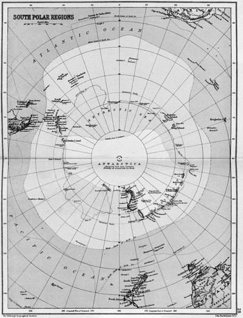
In 1880 management of the family firm had passed into the hands of John George Bartholomew, then only twenty years of age. That his interests and ambitions extended beyond mapmaking was plain from the grand title he began using for his business: the Edinburgh Geographical Institute. While still in his mid-twenties he became founding secretary of the Royal Scottish Geographical Society. In 1886 he drew a ‘South Polar Chart’ to illustrate an article that Murray had written for the society's magazine. A dotted line that surrounded the South Pole was explained as the ‘Supposed Outline of Antarctic Continent (Murray)’ (Murray Reference Murray1886: 532, 576–577). After he had completed the maps that digested the work of the Challenger Commission, Bartholomew had come to a more definite view. In an atlas that he edited for T. Nelson and Sons he published a second state of the Murray map (Bartholomew Reference Bartholomew1890: 28)’. The supposed outline was now labelled ‘ANTARCTICA (Unexplored South Polar Continent) (Probably all covered with Ice Sheet)’. (Fig. 1)
The 1890 map in which Bartholomew formally attached the label Antarctica to the south polar continent (Courtesy of the National Library of Australia).

In 1893 Murray was invited to London by the Royal Geographical Society to present his case for more Antarctic research. With him went a third state of the map. The outline was now labelled ‘ANTARCTICA (after Murray)’. In his address Murray initially spoke of ‘the Antarctic’, but then, shortly after he first referred to the map, he casually mentioned Antarctica and used the word intermittently thereafter. In the ensuing discussion his lead was followed by a Challenger colleague, Alexander Buchan, but the other discussants persisted with ‘the Antarctic’ (Murray Reference Murray1894:1–42).
Bartholomew promoted his neologism with greater determination. The Scotsman received a poem that it published on 10 December 1898 as the work of J.G.B., an otherwise anonymous contributor. The poem was entitled Antarctica.
A commercial mapmaker has media other than patriotic verse at his disposal. Bartholomew used the new term not only in his firm's own maps but also in the popular atlases he edited for other publishers, for example, John Walker's Century atlas (Bartholomew cReference Bartholomew1900: 10) and George Newnes’ XX century citizens’ atlas (Bartholomew [Reference Bartholomew1902]: 12).’
In 1902, Edwin Swift Balch, an American defender of Wilkes, noted that ‘Antarctica is a term which is slowly coming into use’ and probably ‘will be adopted generally’. He did not specifically mention Bartholomew in this connection, but cited at least three Bartholomew ‘Antarctica’ maps published from 1890 onwards (Balch Reference Balch1902: 11, 164–165). Old habits die hard, but during the heroic age of south polar exploration a consensus emerged. ‘The Antarctic’ was taken to encompass whatever lay near or within the Antarctic circle, land, water and ice. ‘Antarctic continent’ was still commonly used to denote the supposed land area, but as its supposed outline became more definite (embracing a much larger area around the pole than Murray had originally dared to suggest) the more need there was for a name rather than a description. The Bartholomew label was self-explanatory and historically proper. After 1920 sentiment also came into play. In that year Bartholomew, by then honorary Geographer to the King, succumbed to an illness that had dogged him since childhood.
After Bartholomew
Eight years later J. Gordon Hayes described Bartholomew as ‘the modern sponsor’ of the name Antarctica and recorded that the Scot had persuaded such polar luminaries as Mawson, Amundsen and Nordenskjöld to adopt it, ‘so there seems no reason for hesitation for doing so.’ But hesitate he did. Hayes considered Ross, Scotia, Shackletonia and Mawsona before dismissing all discoverers’ names as non-descriptive. Australia was ‘obviously correct’ but it had been taken. Ultima was ‘the best alternative’, but unattractive and long associated with the north. He objected that Antarctica was ‘not a very neat word’, but acknowledged that it contained no more syllables than America. He supposed that time would make it familiar to the public, as it had already been ‘generally received’ by geographers (Hayes Reference Hayes1928: 4–5). What else was there to do but surrender? Like Balch, he called his book Antarctica.
Balch and Hayes read the signs aright. In the twenty-first century Bartholomew's label has established itself beyond challenge. Even a canvassing of alternatives, such as Hayes attempted, would today be a futile exercise.