1. Introduction
Crustal block rotation about vertical axes is a common feature of intra-continental strike-slip fault zones, in particular of areas in which deformation is distributed over a wide zone (e.g. Ron et al. Reference Ron, Freund and Garfunkel1984; Luyendyk et al. Reference Luyendyk, Kamerling, Terres and Hornafius1985; McKenzie & Jackson, Reference McKenzie and Jackson1986; Nicholson et al. Reference Nicholson, Seeber, Williams and Sykes1986; Mattei et al. Reference Mattei, Cifelli, Muttoni and Zanchi2012). Classically, palaeomagnetic, geodetic, seismic and structural studies have provided compelling evidence for block rotation. In addition, in a few cases palaeocurrent directions have been used as geometric markers for tracking strain in areas of tectonic vertical axis rotation or orocline bending with variable success (e.g. Shaw et al. Reference Shaw, Johnston, Gutiérrez-Alonso and Weil2012). Debate over models for block rotation has concentrated on two main groups, continuum and discrete models (e.g. McKenzie & Jackson, Reference McKenzie and Jackson1986; King et al. Reference King, Oppenheimer and Amelung1994; Peacock et al. Reference Peacock, Anderson, Morris and Randall1998). Discrete models involve rigid block rotation accommodated by sets of large faults, which causes the development of triangular overlaps (shortening) and voids (extension) at the zone margins. In areas of overlap local convergence produces folding and reverse faulting (e.g. Şengör et al. Reference Şengör, Görür, Şaroğlu, Biddle and Christie-Blick1985), while areas of voids are filled by magmatic intrusions (Tikoff & Teyssier, Reference Tikoff and Teyssier1992), salt diapirs (Hudec & Jackson, Reference Hudec and Jackson2007) or sedimentary basins (Luyendyk et al. Reference Luyendyk, Kamerling and Terres1980).
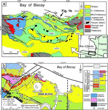
The Pyrenean domain has been traditionally considered the Cretaceous transcurrent boundary between Europe and Iberia plates. Most studies point out a distributed wide wrench boundary where sinistral strike-slip movements along E–W to NW–SE faults were responsible for transtension (e.g. Van der Voo, Reference Van der Voo1969; Puigdefàbregas & Souquet, Reference Puigdefàbregas and Souquet1986; Choukroune, Reference Choukroune1992; Larrasoaña et al. Reference Larrasoaña, Parés, del Valle and Millán2002) (Fig. 1a). In the western Pyrenees, the mid-Cretaceous tectonic pattern of the Basque–Cantabrian Basin indicates that the filling of this basin was mainly controlled by transtension, particularly during Albian times. In this basin, a lot of different syndepositional tectonic structures and other features related to strike-slip tectonics have been documented (García-Mondéjar et al. Reference García-Mondéjar, Agirrezabala, Aranburu and Fernández-Mendiola1996). Besides sedimentation, other coeval geological processes such as hydrothermal venting and mineralization (Aranburu et al. Reference Aranburu, Fernández-Mendiola, López-Horgue and García-Mondéjar2002; Agirrezabala Reference Agirrezabala2009; López-Horgue et al. Reference López-Horgue, Iriarte, Schröder and Fernández-Mendiola2010), iron carbonate ore formation, magmatism (Castañares et al. Reference Castañares, Robles, Gimeno and Vicente-Bravo2001; Fernández-Mendiola & García-Mondéjar, Reference Fernández-Mendiola and García-Mondéjar2003) and hydrocarbon accumulation has been interpreted as controlled by Albian tectonic structures (García-Mondéjar, Reference García-Mondéjar, Tankard and Balkwill1989). The aim of this work is to provide new stratigraphic, structural, palaeocurrent and palaeomagnetic data supporting Albian vertical-axis rotation of the c. 7 km2 Deba block. The obtained results allow us to construct a comprehensive block rotation model which explains coeval tectonic deformations, emplacement of magmatic intrusions, hydrocarbon venting and hydrothermal mineral formation recorded in the margins of the Deba block.
(a) Geological map of the Basque–Cantabrian Basin with indication of the study area depicted in (b). LF: Lekeitio fault; BF: Berriatua fault; EF: Elgoibar fault. (b) Detailed geological map of the Deba block and neighbouring areas. Palaeocurrent localities (squares) and palaeomagnetic sites (circles) are indicated. Inset shows equal-area stereographic projection of stratification poles of the conical Aitzeta syncline (AS) and resulting best-fit small circle, conical fold axis and its semi-apical angle (α/2). X–X′ indicates the trace of the cross-section shown in Figure 4b, and Y–Y′ indicates the trace of the seismic section shown in Figure 12.

2. Geological setting
The Basque–Cantabrian Basin in the western Pyrenees (Fig. 1a) was a Mesozoic peri-cratonic rift related to the opening of the Bay of Biscay and North Atlantic Ocean (Montadert et al. Reference Montadert, Winnock, Deltiel, Grau, Burk and Drake1974; Choukroune & Mattauer, Reference Choukroune and Mattauer1978; Rat et al. Reference Rat, Amiot, Feuillée and Floquet1983; Engeser & Schwentke, Reference Engeser and Schwentke1986; Rat, Reference Rat1988; García-Mondéjar, Reference García-Mondéjar, Tankard and Balkwill1989) and inverted during Tertiary compression (Cámara, Reference Cámara1997; Gómez et al. Reference Gómez, Vergés and Riaza2002). The basin experienced a mid-Cretaceous phase of quick subsidence in a regional transtensional regime related to the left-lateral drift of Iberia (Van der Voo, Reference Van der Voo1969; Rat et al. Reference Rat, Amiot, Feuillée and Floquet1983; Puigdefàbregas & Souquet, Reference Puigdefàbregas and Souquet1986; García-Mondéjar, Reference García-Mondéjar, Tankard and Balkwill1989; García-Mondéjar et al. Reference García-Mondéjar, Agirrezabala, Aranburu and Fernández-Mendiola1996, Reference García-Mondéjar, Fernández-Mendiola, Agirrezabala, Aranburu and Vera2004a , b; Olivet, Reference Olivet1996). Resulting sinistral strike-slip movements were distributed in a wide zone along the Iberia–Europe plate boundary (Choukroune, Reference Choukroune1992; García-Mondéjar et al. Reference García-Mondéjar, Agirrezabala, Aranburu and Fernández-Mendiola1996). The extreme stretching and thinning of the crust reached a maximum during mid-Cretaceous times (Pedreira et al. Reference Pedreira, Pulgar, Gallart and Díaz2003, Reference Pedreira, Pulgar, Gallart and Torné2007; García-Mondéjar et al. Reference García-Mondéjar, Fernández-Mendiola, Agirrezabala, Aranburu and Vera2004a ; Jammes et al. Reference Jammes, Manatschal, Lavier and Masini2009), with the occurrence of submarine volcanism and shallow-level magmatic intrusions (Rossy, Reference Rossy1988; Castañares et al. Reference Castañares, Robles, Gimeno and Vicente-Bravo2001; Fernández-Mendiola & García-Mondéjar, Reference Fernández-Mendiola and García-Mondéjar2003) but without full development of an ocean. Magmatic intrusions emplaced in organic-rich deposits triggered contact metamorphism of host organic matter and the generation of hydrocarbon-rich fluids, which seeped to the Albian palaeoseabed (Agirrezabala et al. Reference Agirrezabala, Kiel, Blumenberg and Schäfer2013). In addition, local high-temperature metamorphism (Azambre & Rossy, Reference Azambre and Rossy1976) and hydrothermal Zn–Pb (among others) ore formation (García-Mondéjar, Reference García-Mondéjar, Tankard and Balkwill1989; Agirrezabala & García-Mondéjar, Reference Agirrezabala and García-Mondéjar2001a ; Aranburu et al. Reference Aranburu, Fernández-Mendiola, López-Horgue and García-Mondéjar2002; López-Horgue et al. Reference López-Horgue, Iriarte, Schröder and Fernández-Mendiola2010) took place in the basin during the mid-Cretaceous period. The local distribution of magmatic rocks, hydrothermal ore deposits and hydrocarbons in the basin is interpreted to have been controlled by the intersection of two NW- and SE-trending fault systems (García-Mondéjar, Reference García-Mondéjar, Tankard and Balkwill1989; García-Mondéjar et al. Reference García-Mondéjar, Agirrezabala, Aranburu and Fernández-Mendiola1996; Castañares et al. Reference Castañares, Robles, Gimeno and Vicente-Bravo2001).
Mid-Cretaceous strike-slip tectonics affected mainly the northern margin of the Basque–Cantabrian Basin, where both syndepositional transtensional and transpressive deformations (faults and folds) and vertical-axis block rotations have been documented (Agirrezabala & García-Mondéjar, Reference Agirrezabala and García-Mondéjar1992, Reference Agirrezabala and García-Mondéjar1994; García-Mondéjar et al. Reference García-Mondéjar, Agirrezabala, Aranburu and Fernández-Mendiola1996; Agirrezabala et al. Reference Agirrezabala, Owen and García-Mondéjar2002; Larrasoaña et al. Reference Larrasoaña, Parés, del Valle and Millán2002). This margin constituted in Albian–Cenomanian times a sinistral wrench corridor composed of both ESE- to E-trending strike-slip major faults and transversal NE- to N-trending minor faults which compartmentalized the margin in small blocks (the Deba block studied here), creating small deep-water sub-basins (Agirrezabala & García-Mondéjar, Reference Agirrezabala and García-Mondéjar1994, Reference Agirrezabala and García-Mondéjar2001a ; García-Mondéjar et al. Reference García-Mondéjar, Agirrezabala, Aranburu and Fernández-Mendiola1996). These sub-basins were filled by NE-derived siliciclastic turbidite systems, which constitute the Middle Albian – Lower Cenomanian Black Flysch Group (Souquet et al. Reference Souquet, Debroas, Boirie and Pons1985). Regional turbiditic dispersion systems and palaeocurrents were parallel to the confining tectonic structures, usually showing a L-shaped pattern with SSW-directed proximal dispersion and palaeocurrents and ESE-directed distal dispersion and palaeocurrents within the inner part of the basin (Agirrezabala & García-Mondéjar, Reference Agirrezabala and García-Mondéjar1994; García-Mondéjar et al. Reference García-Mondéjar, Fernández-Mendiola, Agirrezabala, Aranburu and Vera2004b ; Agirrezabala & Bodego, Reference Agirrezabala and Bodego2005).
3. Stratigraphy
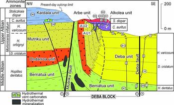
Rocks cropping out in the Deba block and adjacent areas belong mainly to the Black Flysch Group, which is subdivided into seven informal Middle – Late Albian lithostratigraphic units (Figs 1b, 2). Stratigraphic, sedimentological, geochemical and structural data and interpretations relative to these deep-water units have been documented in detail by L. M. Agirrezabala (unpub. Ph.D.thesis, Euskal Herriko Unibertsitatea, 1996), Agirrezabala et al. (Reference Agirrezabala, Owen and García-Mondéjar2002, Reference Agirrezabala, Owen and García-Mondéjar2003, Reference Agirrezabala, Dorronsoro and Permanyer2008) and Agirrezabala (Reference Agirrezabala2009). The stratigraphic record of the area is marked by two important tectono-sedimentary events that occurred at the Late Albian C. auritus ammonite Subzone (M. inflatum Zone). Ammonite biozonation has been the traditional primary standard for subdividing most of the Cretaceous period and yields the maximum biostratigraphic resolution for the Albian stage. The Albian absolute time scale and durations of its biozones are derived from cyclo-stratigraphy (Grippo et al. Reference Grippo, Fischer, Hinnov, Herbert, D'Argenio, Fischer, Premoli Silva, Weissert and Ferreri2004; Ogg et al. Reference Ogg, Agterberg, Gradstein, Gradstein, Ogg and Smith2004). In the case of the Late Albian M. inflatum ammonite Zone, a duration of 5.5 Ma is estimated. That zone is composed of four subzones with an assigned equal duration of 1.3 Ma (Ogg et al. Reference Ogg, Agterberg, Gradstein, Gradstein, Ogg and Smith2004).
Lithostratigraphy and ammonite biostratigraphy of the Black Flysch Group deposits in the study area. Palaeocurrent localities (squares) with their corresponding succession interval (segment line) and palaeomagnetic sites (circles) are shown. AU1 and 2 are angular unconformities.

At the north-western margin of the Deba block, a wedge of syntectonic deposits with abundant coarse breccias and two (high-angle) angular unconformities (AU1 and AU2) of C. auritus Subzone age (Alkolea unit, Figs 1b, 2) record the growth of a monoclinal syncline interpreted to be associated with the Mutriku fault (Agirrezabala et al. Reference Agirrezabala, Owen and García-Mondéjar2002). Overlying post-auritus turbidites (Arbe unit) onlap north-westwards and fossilize the resultant fold (Figs 1b, 2) (Agirrezabala et al. Reference Agirrezabala, Owen and García-Mondéjar2002). Two contemporaneous authigenic carbonate lenses occur in C. auritus syntectonic deposits adjacent to the Mutriku fault (Fig. 2). A multidisciplinary study of these carbonates indicates that they constitute microbially mediated by-products of hydrocarbon-rich hydrothermal venting associated with the activity of the Mutriku fault (Agirrezabala, Reference Agirrezabala2009). Estimated fluid palaeotemperatures up to 109 °C, together with organic geochemical correlation, indicate that vented oil and thermogenic methane were generated at shallow depths from Black Flysch organic matter by contact alteration with hydrothermal fluids (Agirrezabala et al. Reference Agirrezabala, Dorronsoro and Permanyer2008; Agirrezabala, Reference Agirrezabala2009). Pre-auritus rocks of the south-western part of the study area host hydrothermal mineralizations, Pb–Zn deposits (EEE, 2003) and pyrobitumen fills (Figs 1b, 2).
4. Block bordering faults and deformation structures
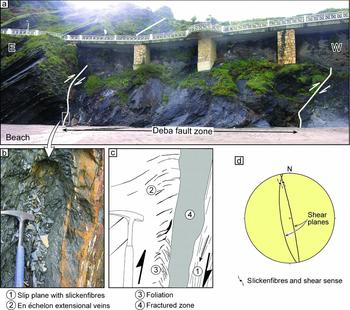
The Deba block is bordered by two ESE-trending main faults, namely the Lekeitio fault to the NE and the Berriatua fault to the SW, and two transversal NE- and N-trending minor faults, namely the Mutriku fault to the NW and the Deba fault to the E. These define a trapezoidal-shaped non-faulted rock unit of c. 7 km2 (Fig. 1b). Based on different geological data, ESE- and E-trending major faults of the northern margin of the basin have been traditionally interpreted as mid-Cretaceous sinistral strike-slip faults along which eastwards movement of the Iberian plate took place (Rat et al. Reference Rat, Amiot, Feuillée and Floquet1983; García-Mondéjar et al. Reference García-Mondéjar, Agirrezabala, Aranburu and Fernández-Mendiola1996; Larrasoaña et al. Reference Larrasoaña, Parés, del Valle and Millán2002; Iriarte, Reference Iriarte2005). Moreover, kinematic indicators from the fault zones confirm left-lateral movements along them (Agirrezabala & García-Mondéjar, Reference Agirrezabala and García-Mondéjar2001a ), although no displacement magnitudes for individual faults are available. Stratigraphic and structural analysis of the minor NE-trending Mutriku fault and associated Aitzeta growth fold (Fig. 1b) suggests Late Albian right-lateral movements along this fault (Agirrezabala et al. Reference Agirrezabala, Owen and García-Mondéjar2002). The N-trending Deba fault zone shows kinematic indicators such as striation on shear planes, slickenfibres, en échelon extensional veins and foliation indicative of dextral strike-slip faulting (Fig. 3). Additionally, mapping of the Deba fault also shows a right-lateral offset of 200 m and a reverse dip-slip component in its southern part of c. 200–300 m (Fig. 1b).
Outcrop of the Deba fault zone at the Deba beach. (a) Photograph of the Deba fault zone and adjacent thin-bedded turbidite succession (Deba unit); (b) detail photograph of (a); (c) drawing of (b) showing different kinematic indicators (slip plane, slickenfibres, en échelon extensional veins, foliation and fractured zone) suggesting dextral strike-slip faulting; and (d) equal-area stereographic projection of two major shear planes and associated slickenfibres from the Deba fault zone indicative of dextral strike-slip movements.

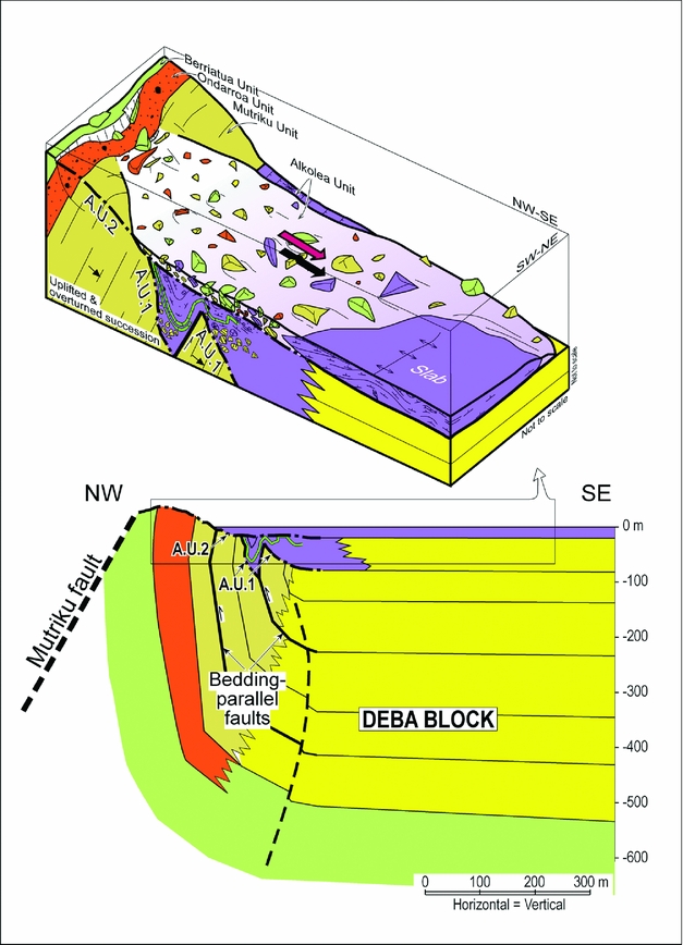
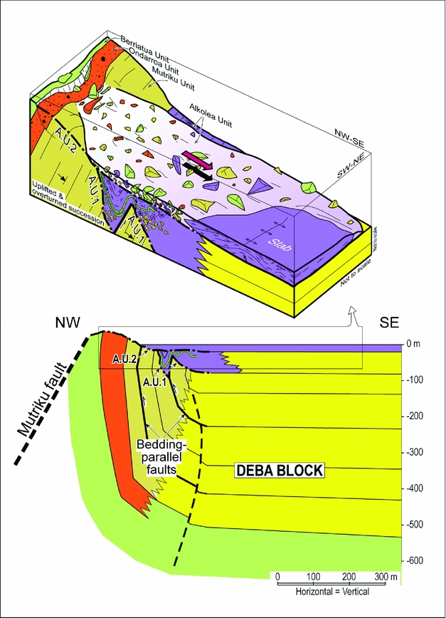
In the NW corner of the Deba block, the Aitzeta monoclinal syncline (Figs 1b, 4) appears adjacent and parallel to the Mutriku fault (Agirrezabala et al. Reference Agirrezabala, Owen and García-Mondéjar2002). At present, it reaches 2 km (minimum) in strike length and 0.5 km (maximum) in dip-direction width and strikes NE. The Aitzeta monocline depicts a vertical limb striking NE which crops out for 2 km immediately west of the Mutriku fault while its horizontal limb is interpreted to underlie the rest of the Deba block. The vertical limb brings up to 500 m of the Middle–Upper Albian rocks to the surface in the NW, while it becomes narrower to the SW until it disappears. Both mapping and bedding attitudes indicate that the Aitzeta syncline is a conical fold (axis: 255/67°; semi-apical angle α/2: 64°) (Fig. 1b). The wedge of syntectonic deposits (Alkolea unit) that overlaps the south-eastern margin of the structure and related angular unconformities (AU1 and 2) record the two-pulse growth of the Aitzeta monoclinal syncline during the Late Albian auritus Subzone. A cross-section of the structure restored at the end of auritus Subzone time shows that it constitutes the subvertical limb of a fault-related syncline (Fig. 4). Structural analysis and clast stratigraphy of syntectonic deposits indicate that the growth of this structure carried out the uplift and erosive denudation of 350–390 m (minimum) of underlying rocks (Agirrezabala et al. Reference Agirrezabala, Owen and García-Mondéjar2002). The presence of bedding-parallel faults which cut overlying angular unconformity 1 and cause drape folding of the syntectonic deposits (Fig. 4) is interpreted as a result of flexural slip folding (Alonso, Reference Alonso1989). During the rotation and uplift of the limb a SE-facing erosive talus developed; fragments of underlying units were resedimented at the base of this (Fig. 4).
Cross-section of the NW margin of the Deba block restored at the end of auritus Subzone, showing the Aitzeta monoclinal syncline adjacent to the Mutriku fault (modified from Agirrezabala et al. Reference Agirrezabala, Owen and García-Mondéjar2002) (lower). For location, see Figure 1b. Interpretative block diagram illustrating limb rotation, uplift, denudation and resedimentation processes as a consequence of the growth of the Aitzeta syncline at the end of the auritus Subzone (upper).
5. Palaeocurrents
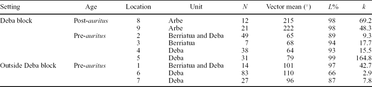
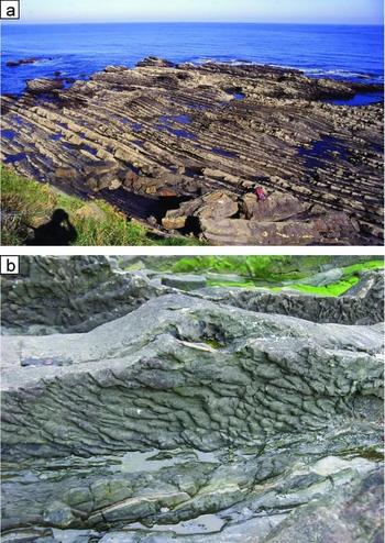
A total of 282 palaeocurrents distributed at 9 localities were measured from sole mark structures (flute, prod, crescent, groove, bounce and skip casts) of sandy turbidite successions (Figs 1b, 2, 5). Four of these successions were also sampled for palaeomagnetic analyses. Obtained palaeocurrent data and statistical parameters are listed in Table 1 and corresponding rose diagrams are plotted in Figure 6a. They were collected from pre- and post-auritus strata both inside and outside of the Deba block. No palaeocurrents have been measured NW of the Mutriku fault because of the absence of good-quality outcrops of turbiditic strata. Folds in the measured sections indicate a horizontal axis; tilting of sedimentary structures was therefore corrected by rotation about the horizontal axis.
Palaeocurrent statistical data. Measured sedimentary structures are sole marks from sandy turbidites. Location numbers correspond to those in Figures 1b, 2; N population size; L% vector length (%); k concentration factor.

(a) Outcrop of a distal sandy turbidite succession of the Deba unit. All the palaeocurrent measurements and most of the palaeomagnetic data were obtained from similar turbidite successions. (b) Detail photograph of a sandy turbidite sole with flute casts (flow to the right). Pencil for scale (centre of the photograph).


5.a. Palaeocurrent results
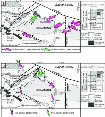
The palaeocurrent rose diagrams for each locality show low dispersion (Table 1, Fig. 6a). The palaeocurrent directions map indicates three directional groups of palaeocurrent roses related by their stratigraphic and structural position (Fig. 6a). In the Deba block, palaeocurrents from pre-auritus rocks yield mean palaeoflow directions toward N64°E to N79°E whereas mean palaeocurrents from post-auritus strata indicate palaeoflows toward N215°E to N222°E. Outside of the Deba block, mean palaeocurrents from pre-auritus rocks indicate N96°E- to N110°E-directed palaeoflows. Among the three directional groups there are no transitional palaeocurrent directions even between very close localities.
6. Palaeomagnetism
A total of 75 samples for palaeomagnetic study were collected from 9 sites corresponding to the turbiditic Black Flysch Group deposits (lutites and siderites) (Figs 1b, 2, 5a). Five of these palaeomagnetic sites coincide with palaeocurrent localities. Samples were collected and oriented in situ with a gasoline-powered drill and orienting device, respectively. Core samples were cut in the laboratory in standard palaeomagnetic samples for measurements. Natural remanent magnetization (NRM) and remanence following demagnetization steps were measured on a 2G Enterprises DC SQUID (superconducting quantum interference device) high-resolution pass-through cryogenic magnetometer (manufacturer noise level of 10−12 A m2) operated in a shielded room at the Istituto Nazionale di Geofisica e Vulcanologia (INGV) in Rome, Italy. A Pyrox oven in the shielded room was used for thermal demagnetizations and alternating field (AF) demagnetization was performed with three orthogonal coils installed inline with the cryogenic magnetometer. A stepwise AF protocol and a combined AF and thermal protocol were used for demagnetization of samples. The presence of siderite (antiferromagnetic) in much of the studied samples (Gil et al. Reference Gil, Yusta, Herrero and Velasco1986), which easily oxidizes to secondary magnetic minerals (magnetite, maghemite and hematite; e.g. Ellwood et al. Reference Ellwood, Chrzanowski, Hrouda and Long1988; Pan et al. Reference Pan, Zhu and Banerjee2000), prompted us to use a specifically designed thermal demagnetization protocol. Samples were initially demagnetized in four AF steps up to 20 mT before stepwise thermal demagnetization. After each thermal step remanence was measured, a single step of 20 mT was applied and remanence was remeasured before the next thermal step. This strategy aimed to minimize spurious secondary remanence acquisition produced by the by-products of eventual siderite alteration upon heating.
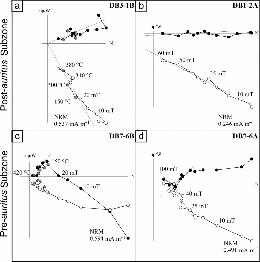
Demagnetization data were plotted on standard orthogonal plots. NRM components were calculated using principal component analysis and standard Fisher statistics was applied to compute mean directions. For samples demagnetized using the combined AF and thermal protocol, the characteristic remanent magnetization (ChRM) is computed using only the measurement after the 20 mT step after the heating step (Fig. 7). In addition, inclination-only means were computed using the software PmagTools (Mark W. Hounslow, CEMP, Lancaster, UK) using statistics in McFadden & Reid (Reference McFadden and Reid1982). Tectonic-corrected data implied a simple bedding correction with the exception of data from site DB5 which is affected by a plunging cylindrical fold (Aitzeta syncline) (Fig. 1b). Consequently, palaeomagnetic declination has been corrected for apparent palaeomagnetic rotation (sensu lato) by –26° following Pueyo et al. (Reference Pueyo, Parés, Millán and Pocoví2003, p. 354).
(a)–(d) Bedding-corrected orthogonal plots of demagnetization data from representative pre-auritus and post-auritus rocks. Solid (open) circles represent projections onto the horizontal (vertical) plane. The fitted ChRM component is shown. For the combined AF and thermal demagnetization (a, c) shaded points indicate the heating step excluded for the ChRM calculation. The intensity of the initial NRM and the demagnetization treatment for some steps are indicated.

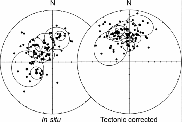
Equal-area projections of the ChRM directions before (in situ) and after tectonic correction for all sites (Table 2). The 95% confidence ellipse for the mean directions is plotted.

In order to evaluate the presence of tectonic rotations around the vertical axis in the studied zone, the European reference direction has been used. The western Pyrenees, and more specifically the studied zone, has been traditionally considered as part of the European plate; the European reference direction has therefore usually been used in palaeomagnetic studies (Vandenberg, Reference Vandenberg1980; Schott & Peres, Reference Schott and Peres1988; Van der Voo, Reference Van der Voo1993; Schott & Parés, Reference Schott, Parés, Barnolas, Chiron and Guérangé1996; Larrasoaña et al. Reference Larrasoaña, Parés, del Valle and Millán2002). The mean Lower Cretaceous (Kl, 98–144 Ma) palaeopole for the European plate computed by Van der Voo (Reference Van der Voo1993) from a selection of four poles with reliability criteria Q>3 (Lat/Long = 70/193) implies a reference direction of declination/inclination or D/I = 354/42 in the study area.
6.a. Palaeomagnetic results
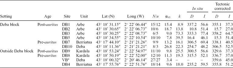
NRM intensities were of the order 0.05–0.8 mA m−1. AF and combined thermal demagnetization protocols provide similar results (Fig. 7). Samples normally unblock a viscous component at 5 mT probably related to drilling or storage. A low-coercivity and low-temperature component is then removed by fields of c. 25–20 mT or 150–200 °C. This component represents a recent secondary overprint conforming to the present geomagnetic field. At higher fields up to 100 mT and maximum temperatures of 420–500 °C a characteristic component (ChRM) that normally trends to the origin of the diagram is finally removed. Data from a Deba site in Vandenberg (Reference Vandenberg1980) has also been taken into account in this study. Palaeomagnetic data and statistical parameters for all sites are listed in Table 2 and corresponding site means are plotted in Figures 6b, 8, 9b, c. The polarity of all ChRM components is normal as it would correspond to a primary direction of the Albian age of the rocks, which falls in the Cretaceous Long Normal superchron. The distribution of sites in different tectonic blocks and their limited bedding attitudes prevents a proper fold test being performed. Moreover, the presence of internal vertical-axis rotation in the Deba block also hampers a regional fold test. An inclination-only mean considering all sites has been computed at sample level. The mean inclination after tectonic correction (I = 41.9, α 95 = 3.8, k = 14.26, N = 79) has only slightly better statistical parameters than the mean inclination before tectonic correction (I = 54.6, α 95 = 4.7, k = 15.36, N = 79) denoting the overall similar bedding attitude. Despite no conclusive field test, we interpret the computed ChRM as representative of a primary Albian direction that records vertical-axis block rotation. The mean directions for the pre- and post-auritus rocks from the Deba block calculated at sample level are listed in Table 3. The angle of rotation R calculated by comparing the measured declination with the European reference direction and its error ΔR following the statistical method proposed by Demarest (Reference Demarest1983) are provided.
Site mean palaeomagnetic results (N/n number of samples measured/used to compute mean direction; D declination; I inclination; k Fisher's precision parameter; α 95 radius of the 95% confidence cone)

*Vandenberg's (Reference Vandenberg1980) Deba site data
Site group mean palaeomagnetic results for the Deba block data calculated at sample level (N/n, D, I, k, α 95 as for Table 2; R angle of rotation; ΔR error)

7. Discussion
7.a. Evidence for Albian block rotation
Different contemporaneous geological processes such as local deformation, hydrothermal venting and possibly magmatic and/or salt diapiric intrusions recorded at the corners of the Deba block are interpreted to have occurred as the consequences of the anticlockwise rotation of this block during Late Albian auritus Subzone. This block rotation is supported by obtained palaeocurrent directions and palaeomagnetic results.
7.a.1. Local transpression
In the NW corner of the Deba block, syntectonic deposits of auritus Subzone age (Figs 1b, 2) record the growth of the NE-trending SE-facing Aitzeta monoclinal syncline, interpreted as the subvertical limb of a fault-related syncline (Agirrezabala et al. Reference Agirrezabala, Owen and García-Mondéjar2002). A restored cross-section to the top of growth deposits indicates that tectonic shortening for the end of auritus Subzone is c. 500 m (Fig. 4). It formed in response to local NW–SE compressive stress along the north-eastern part of the dextral-reverse Mutriku fault. The attenuation and end of the Aitzeta syncline to the SW indicates the progressive diminishing of the shortening in the same sense, from at least 0.5 km (Fig. 4) to zero. This differential shortening along the Mutriku fault suggests an anticlockwise rotational movement of the adjacent Deba block.
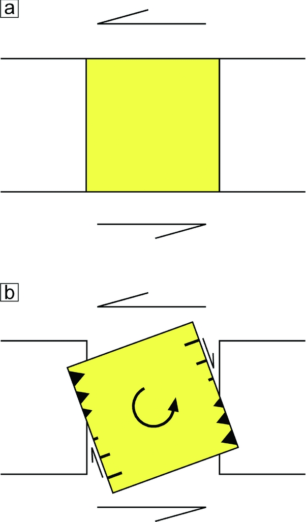
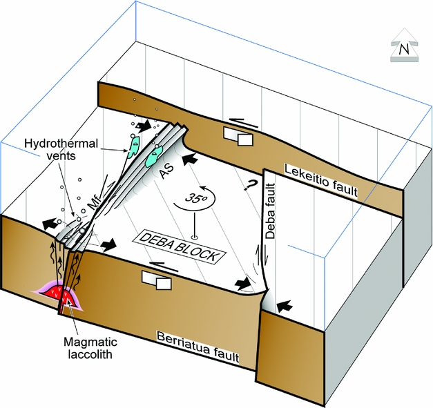
Rigid block rotation can happen in synthetic or antithetic senses. A synthetically rotated block model postulates block bordering antithetic minor faults at high angles to the main faults (Freund, Reference Freund1974; Nicholson et al. Reference Nicholson, Seeber, Williams and Sykes1986). An antithetically rotated block model predicts block bordering synthetic minor faults at low angles to the main faults (Jordan, Reference Jordan1991; Gross et al. Reference Gross, Becker and Gutiérrez-Alonso1997). In the Deba case, sinistral block rotation occurs between left-lateral major strike-slip faults and is bordered by minor antithetic right-lateral faults, as the synthetically rotated block model postulates. This block rotation model also predicts the formation of transpressive structures at opposite corners and transtensive structures at the other two corners as a solution to the space problems (Fig. 10). Following this model, we interpret the transpressive Aitzeta fold formation at the NW corner of the Deba block as the direct consequence of the local compression resulting from the anticlockwise rotation of that block (Fig. 11). In the opposite SE corner of the block, the southern part of the Deba fault shows a dextral-reverse character affecting pre-auritus rocks (Figs 1b, 3). Although the dextral-reverse movement cannot be precisely dated because of a lack of auritus and post-auritus deposits, we interpret this movement as the result of local E–W compression triggered by the Deba block rotation during C. auritus Subzone times (Fig. 11).
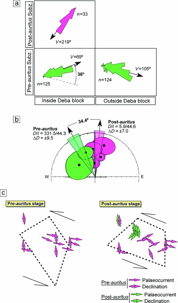
(a) Palaeocurrent roses of pre-auritus and post-auritus rocks from inside and outside the Deba block. (b) Stereographic projection of pre-auritus and post-auritus site means (Table 2) from the Deba block and group mean directions calculated at sample level (Table 3). (c) Two-stage (pre- and post-auritus) sketch showing palaeocurrent and palaeomagnetic declination mean directions and interpreted rotation of the Deba block.

Sketch of synthetic block rotation model: (a) initial situation and (b) synthetically rotated block bordered by antithetic minor faults and formation of transpressive structures (teeth) at opposite corners and transtensive structures (hachures) at the other two corners.

Schematic block diagram showing anticlockwise rotation of the Deba block during Late Albian auritus Subzone times. Contemporaneous to block rotation and, as a consequence of the space problem, transpressive deformations took place in its NW and SE corners and transtension in its SW (and NE?) corner. In the transtensive SW corner, magmatic intrusions emplaced by the local discharge of lithostatic pressure triggered the development of a hydrothermal system. This hydrothermal system mineralized host rocks and vented warm to hot fluids rich in oil and methane to the Albian seafloor. These hydrocarbons were generated at shallow depths from Black Flysch organic matter by contact alteration with hydrothermal fluids. AS: Aitzeta monoclinal syncline; Mf: Mutriku fault.

7.a.2. Hydrothermal vents and magmatic intrusions
In recent studies, two hydrothermal vent carbonate lenses and associated chemosymbiotic fauna hosted in the syn-rotational auritus Subzone deposits from both sides of the Mutriku fault (Figs 1b, 2) have been documented in detail (Agirrezabala et al. Reference Agirrezabala, Dorronsoro and Permanyer2008; Agirrezabala, Reference Agirrezabala2009). These carbonates have been interpreted as microbially mediated by-products of hydrocarbon-rich (oil and termogenic methane) hot fluids (up to 109 °C) expelled to the Late Albian sea floor (Agirrezabala, Reference Agirrezabala2009). Geochemical correlation between pyrobitumen-fills from vent carbonates and host rock organic matter suggests that the hydrocarbon source was the Black Flysch Group (Agirrezabala et al. Reference Agirrezabala, Dorronsoro and Permanyer2008). Magmatic intrusion-related contact metamorphism of these organic-rich sediments would have triggered the generation of hydrocarbons, which migrated updip through the Mutriku fault and the steep limb of the Aitzeta monocline to the sea floor.
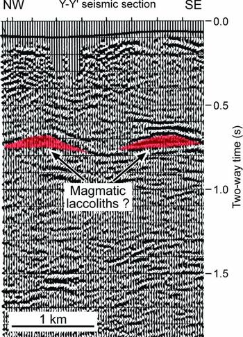
In the present-day Guaymas Basin and NE Pacific Ocean, hydrothermal petroleum and methane is produced at shallow depths from sedimentary organic matter by contact metamorphism around shallow-level magmatic intrusions (Einsele et al. Reference Einsele, Gieskes, Curray and Moore1980; Simoneit & Lonsdale, Reference Simoneit and Lonsdale1982; Rushdi & Simoneit, Reference Rushdi and Simoneit2002). Similarly, this hydrocarbon-generating process has also been interpreted from magmatic sill-intruded ancient sedimentary basins worldwide (Jamtveit et al. Reference Jamtveit, Svensen, Podladchikov, Planke, Breitkreuz and Petford2004; Svensen et al. Reference Svensen, Planke, Malthe-Sørenssen and Jamtveit2004, Reference Svensen, Planke, Polozov and Schmidbauer2009; Ganino & Arndt, Reference Ganino and Arndt2009). In the Basque–Cantabrian Basin, intrusive and extrusive volcanic activity was important in Late Albian and Late Cretaceous times (Rossy, Reference Rossy1988), distinguishing a main activity phase during the auritus Subzone (Castañares et al. Reference Castañares, Robles, Gimeno and Vicente-Bravo2001) penecontemporaneously with the development of the hydrothermal vents here. In this respect, a seismic profile across the SW corner of the Deba block shows the presence of two domal, highly reflective structures at c. 0.7 s depth (Fig. 12). Their concordant, high-amplitude reflections, convex-up tops and flat bottoms and dimensions are compatible with an interpretation of both structures as magmatic laccoliths (Corry, Reference Corry1988; Thompson, Reference Thompson2007) and salt-related domes (Talbot, Reference Talbot1993; Schultz-Ela & Jackson, Reference Schultz-Ela and Jackson1996; Hudec & Jackson, Reference Hudec and Jackson2006). An interpretation of the structures as magmatic intrusions is favoured based on the local high heat flow that supported the hydrothermal activity and hydrocarbon generation at a shallow depth as well as the occurrence of pervasive hydrothermal mineralizations, Pb–Zn deposits and abundant pyrobitumen-fills (EEE, 2003) concentrated in rocks over the domal seismic structures (Figs 1b, 2). In addition, the features have length/thickness ratios comparable to documented magmatic laccoliths from different geological settings (Corry, Reference Corry1988; McCaffrey & Petford, Reference McCaffrey and Petford1997). The igneous character of the seismic structures is also favoured by the important Late Albian magmatism in the area, recorded by the presence of: (1) pyroclastic beds within the studied succesions (auritus and varicosum subzones) (Agirrezabala & García-Mondéjar, Reference Agirrezabala and García-Mondéjar2001 b); (2) mapped magmatic intrusions enclosed in pre-auritus rocks 4 km to the SW (EEE, 2003); and (3) thick volcanic successions and magmatic intrusions along the northern margin of the basin, where the main volcanic activity phase occurred during the auritus Subzone (Rossy, Reference Rossy1988; Castañares et al. Reference Castañares, Robles, Gimeno and Vicente-Bravo2001).
Seismic section across the SW corner of the Deba block showing two highly reflective domal structures. Based on their geometries, dimensions and relationship with the overlying hydrothermal system they are interpreted as magmatic laccoliths. For location see Figure 1b.

Magmatic intrusions (and related hydrothermal fluids) in strike-slip settings are usually emplaced in areas subjected to transtension (e.g. Aydin et al. Reference Aydin, Schultz, Campagna, Boccaletti and Nur1990; Ventura, Reference Ventura1994; Chetty, Reference Chetty1995; Aranguren et al. Reference Aranguren, Tubia, Bouchez and Vigneresse1996; Marra, Reference Marra2001; Adiyaman & Chorowicz, Reference Adiyaman and Chorowicz2002; Breitkreuz & Mock, Reference Breitkreuz, Mock, Breitkreuz and Petford2004; Sapiie & Cloos, Reference Sapiie and Cloos2004; Busby et al. Reference Busby, Bassett, Steiner and Riggs2005; Tibaldi et al. Reference Tibaldi, Pasquarè, Tormey, Cloetingh and Negendank2010). In these areas, a discharge of lithostatic pressure favours the emplacement of magmatic intrusions, and the faults provide preferential magma conduits. In this study, we interpret the emplacement of possible magmatic intrusions and the formation of hydrothermal deposits at the SW corner of the Deba block to have taken place under local extension (Fig. 11). This is in agreement with the SW termination of the compressive Aitzeta fold, which does not reach the SW corner of the Deba block (Fig. 1b). This fact could indicate a transition from compression at the NW corner to extension at the SW corner (Fig. 11).
7.a.3. Palaeocurrent and palaeomagnetic evidence
At the Deba block, pre-auritus palaeocurrent rose diagrams (ENE-directed) show a systematic anticlockwise deviation if comparing with contemporaneous adjacent (and regionally distal) palaeocurrents (ESE-directed) (Fig. 6a). The average of all pre-auritus palaeocurrent directions from the Deba block localities shows a mean palaeoflow direction toward N69°E, while the sum of coeval palaeocurrents at localities outside the Deba block yields a mean palaeoflow direction towards N105°E, resulting in a mean deviation of 36° (Fig. 9a). Moreover, the magnetic declinations of pre-auritus rocks at Deba block sites also show a similar anticlockwise deviation of 22° (± 9) from the Albian European magnetic reference direction (N354°E; Van der Voo, Reference Van der Voo1993) (Table 3, Fig. 9b). In contrast, overlying post-auritus rocks at the Deba block yield palaeocurrent roses concordant with a ‘normal’ regional proximal direction (towards SSW) (Fig. 9a), and the mean of their magnetic declinations shows a clockwise deviation of 12° (±7) from the Albian magnetic reference direction (Table 3, Fig. 9b). Consequently, the anticlockwise rotation of the Deba block is pre-dated by pre-auritus rocks and post-dated by post-auritus rocks, constraining the age of the rotation process to the Late Albian auritus Subzone.
In summary, the palaeocurrent results suggest an anticlockwise rotation of the Deba block of 36° (Fig. 9a) and the palaeomagnetic results indicate a similar rotation of 34° (difference between pre- and post-auritus means at the Deba block; Table 3 and Fig. 9b). The agreement of results obtained from independent datasets provides strong support for the interpretation of the Deba block rotation of c. 35° (mean value between palaeocurrent and declination rotations; Fig. 9c). Moreover, the similar results obtained from palaeocurrent and palaeomagnetic data from the same localities reinforce the inferred rotation of the Deba block. This anticlockwise rotation is in concordance with the Albian sinistral strike-slip tectonics deduced by many authors for both the Basque–Cantabrian Basin (Rat et al. Reference Rat, Amiot, Feuillée and Floquet1983; García-Mondéjar, Reference García-Mondéjar, Tankard and Balkwill1989; García-Mondéjar et al. Reference García-Mondéjar, Agirrezabala, Aranburu and Fernández-Mendiola1996) and the Pyrenean realm (Choukroune & Mattauer, Reference Choukroune and Mattauer1978; Puigdefàbregas & Souquet, Reference Puigdefàbregas and Souquet1986; Olivet, Reference Olivet1996, Larrasoaña et al. Reference Larrasoaña, Parés, del Valle and Millán2002).
West of the Deba block two sites of pre- and post-auritus rocks (DB8 and DB9) show anticlockwise declination deviation of 18° and 33°, respectively, from Albian magnetic reference direction, suggesting for that area an anticlockwise rotation process younger than Late Albian rostratum Subzone (Figs 6b, 9c). Based on geological maps and structural criteria, rotation of this area has been related to the Tertiary inversion tectonics of the basin (L. M. Agirrezabala, unpub. PhD thesis, Euskal Herriko Unibertsitatea, 1996). On the other hand, palaeocurrent directions of the study area show a sharp change from ESE to SSW, coinciding with the auritus Subzone (Figs 6a, 9a, c). This fact suggests that the same tectonic pulse that triggered the rotation of the Deba block also caused the disappearance of the confining southern structural slope responsible of the ESE deflection of pre-auritus turbidity flows. The disappearance of that topographic barrier allows post-auritus turbidity currents to flow in a SSW direction.
7.b. Block rotation rates
Recent work based on sedimentological and structural analyses, combined with precise biostratigraphy of ammonites, documents in detail the growth history of the Aitzeta syncline in the NW corner of the Deba block (Agirrezabala et al. Reference Agirrezabala, Owen and García-Mondéjar2002, Reference Agirrezabala, Owen and García-Mondéjar2003). It developed in two main pulses that were recorded in the Late Albian syntectonic deposits as two high-angle, angular unconformities (AU1 and AU2, base and top of auritus Subzone, respectively; Figs 1b, 2). These two unconformities and related resedimented deposits record strong limb-rotation and uplift of the syncline limb (42° and 250 m in the first pulse and 66° and 100–140 m in the second pulse). Nevertheless, the occurrence of hemipelagic deposits between both angular unconformities indicates an intervening phase of tectonic calm, which lasted c. 0.29 Ma (minimum duration estimated by using average sedimentation rates of hemipelagic sediments; Agirrezabala et al. Reference Agirrezabala, Owen and García-Mondéjar2002). If the auritus Subzone spans 1.3 Ma (Ogg et al. Reference Ogg, Agterberg, Gradstein, Gradstein, Ogg and Smith2004), and 0.29 Ma (minimum) of this represents the tectonic calm (hemipelagic sedimentation), the duration of all deformation phases or angular unconformities is c. 1 Ma (maximum). Consequently, if there is a cause–effect relationship between the Aitzeta fold growth and the Deba block rotation, then two phases can also be invoked for the Deba block rotation with an estimated time span equal to the duration of the two folding pulses, that is, 1 Ma (maximum) for the sum of both pulses. If this duration is assumed for the total rotation (35°) of the Deba block, the minimum block rotation rate calculated is 35° Ma−1. Similar rapid rotation rates have been documented in other strike-slip basins, particularly in areas where blocks are small. Based on palaeomagnetic data from California, Johnson et al. (Reference Johnson, Opdyke, Woodard and Zeitler1983) estimated Quaternary rates of 35° rotation in less than 0.9 Ma for the Vallecito–Fish Creek Basin; Seeber & Bogen (Reference Seeber and Bogen1985) documented 20–30° rotation in the past 0.7–1 Ma in sediments adjacent to the San Jacinto Fault; and Horns & Verosub (Reference Horns and Verosub1995) documented rotation rates of 20° Ma−1 in the San Gregorio fault zone. Rapid rates of rotation of small blocks have also been observed in geodetic data from central California (17° Ma−1; Prescott et al. Reference Prescott, Lisowscki and Savage1981) and Alpine fault system in New Zealand (8° Ma−1; Walcott, Reference Walcott1984). Simple trigonometry and 35° rotation of the 2.1-km-wide Deba block gives 1.2 km displacement (strike-slip component); we therefore derive an estimate of 1.2 km Ma−1 for minimum slip rate on the two major faults.
7.c. Block rotation model
Stratigraphic, structural, subsurface, palaeocurrent and palaeomagnetic data described above support the anticlockwise rotation of the Deba block by c. 35° during Late Albian times (Figs 9c, 11). The rotation of the Deba block is interpreted as related to the left-slip of the NW-trending Lekeitio and Berriatua boundary faults, which belong and are parallel to the wider sinistral wrench corridor defined in the northern margin of the basin (Agirrezabala & García-Mondéjar, Reference Agirrezabala and García-Mondéjar1994, Reference Agirrezabala and García-Mondéjar2001a ; García-Mondéjar et al. Reference García-Mondéjar, Agirrezabala, Aranburu and Fernández-Mendiola1996; Agirrezabala et al. Reference Agirrezabala, Owen and García-Mondéjar2002). Second-order bordering Mutriku and Deba faults trend NE and N, respectively, and show right-lateral slip. Because these faults are oriented at high angles to the general trend of the wrench corridor, and because the sense of slip is in the opposite sense, they can be considered as antithetic strike-slip faults or conjugate Riedel (R’) shears (Tchalenko, Reference Tchalenko1970) characteristics of strike-slip regimes (e.g. Christie-Blick & Biddle, Reference Christie-Blick, Biddle, Biddle and Christie-Blick1985; Sylvester, Reference Sylvester1988). This structural scenario is concordant with the anticlockwise synthetic rotation of the Deba block (Fig. 11), as the block rotation models predict (e.g. Freund, Reference Freund1974; Ron et al. Reference Ron, Freund and Garfunkel1984; McKenzie & Jackson, Reference McKenzie and Jackson1986; Nicholson et al. Reference Nicholson, Seeber, Williams and Sykes1986; Jordan, Reference Jordan1991).
In models of rigid block rotation, blocks do not show internal strain and involved rotation is accommodated by sets of bordering faults (e.g. Ron et al. Reference Ron, Freund and Garfunkel1984; McKenzie & Jackson, Reference McKenzie and Jackson1986). Rotation of rigid blocks causes a space problem at the boundaries between rotated and non-rotated blocks, resulting in triangular areas of overlap (transpression) and void (transtension) in the opposite corners (Fig. 10). This is concordant with the anticlockwise rotation of the Deba block transpressive deformations (reverse faulting, uplift and fold growth) recorded in the opposite NW and SE corners of the block, whereas coeval transtension took place in the alternate SW (and NE) corner where high-level magmatic laccoliths emplaced and the related hydrothermal system developed (Figs 11, 12). In this respect, it has been shown that in a block rotation scenario magmatic intrusions and hydrothermal fluid flow usually locate in transtension corners as a result of local lithostatic discharge (Christie-Blick & Biddle, Reference Christie-Blick, Biddle, Biddle and Christie-Blick1985). These corners may be likely sites for decompression melting, and the faults and fractures could provide preferential conduits for magma and hydrothermal fluids (Chetty, Reference Chetty1995; Marra, Reference Marra2001; Sapiie & Cloos, Reference Sapiie and Cloos2004; Tatar et al. Reference Tatar, Piper, Gürsoy and Heimann2004; Tibaldi et al. Reference Tibaldi, Pasquarè, Tormey, Cloetingh and Negendank2010).
8. Conclusions
Studied deep-water deposits record the syndepositional vertical-axis rotation of the Deba block during Late Albian C. auritus Subzone times. Stratigraphic, structural, subsurface, palaeocurrent and palaeomagnetic data suggests 35° anticlockwise rotation of the Deba block during that time. Deduced anticlockwise block rotation is consistent with the ESE-trending sinistral wrench system of the Basque–Cantabrian Basin. Published biostratigraphic data based on ammonites allow us to constrain the block rotation process to a maximum period of 1 Ma. On the basis of conservative estimations, the block rotation took place at a minimum rate of 35° Ma−1 resulting in a sinistral strike-slip minimum rate of 1.2 km Ma−1.
Vertical-axis rotation of the Deba block caused geometric problems along its contacts with non-rotated adjacent blocks, triggering coeval transpressive and transtensive deformation around its corners. At the NW and SE opposite corners, syndepositional compressive faulting, folding and uplift took place, whereas alternate SW and, possibly, NE corners would have experienced extensional faulting and fracturing. In the extensional SW corner two domal high-reflective structures recorded by seismic profiles have been interpreted as high-level magmatic laccoliths emplaced by local discharge of lithostatic pressure. The emplacement of these magmatic intrusions triggered the development of a mineralizing hydrothermal system, which expelled warm to hot fluids rich in hydrocarbon (oil and methane) to the Albian seafloor. Vented hydrocarbons were generated at shallow depths from Black Flysch organic matter by contact alteration with hydrothermal fluids. The applicability of the comprehensive model is apparent, and it could be relevant to mineral and hydrocarbon exploration in the Basque–Cantabrian Basin and other strike-slip basins.
Acknowledgements
We would like to thank Allen Frankovik and Alex Franco (Energiaren Euskal Erakundea) for their help with interpreting seismic profiles and providing well data, respectively. Gabriel Gutiérrez-Alonso and one anonymous reviewer are thanked for their useful and constructive comments, which help greatly to improve the manuscript. This research was supported by the Euskal Herriko Unibertsitatea (project EHU11/42) and the Ministerio de Ciencia e Innovación (projects CGL2006-05491/BTE and CGL2009-08545).