Introduction
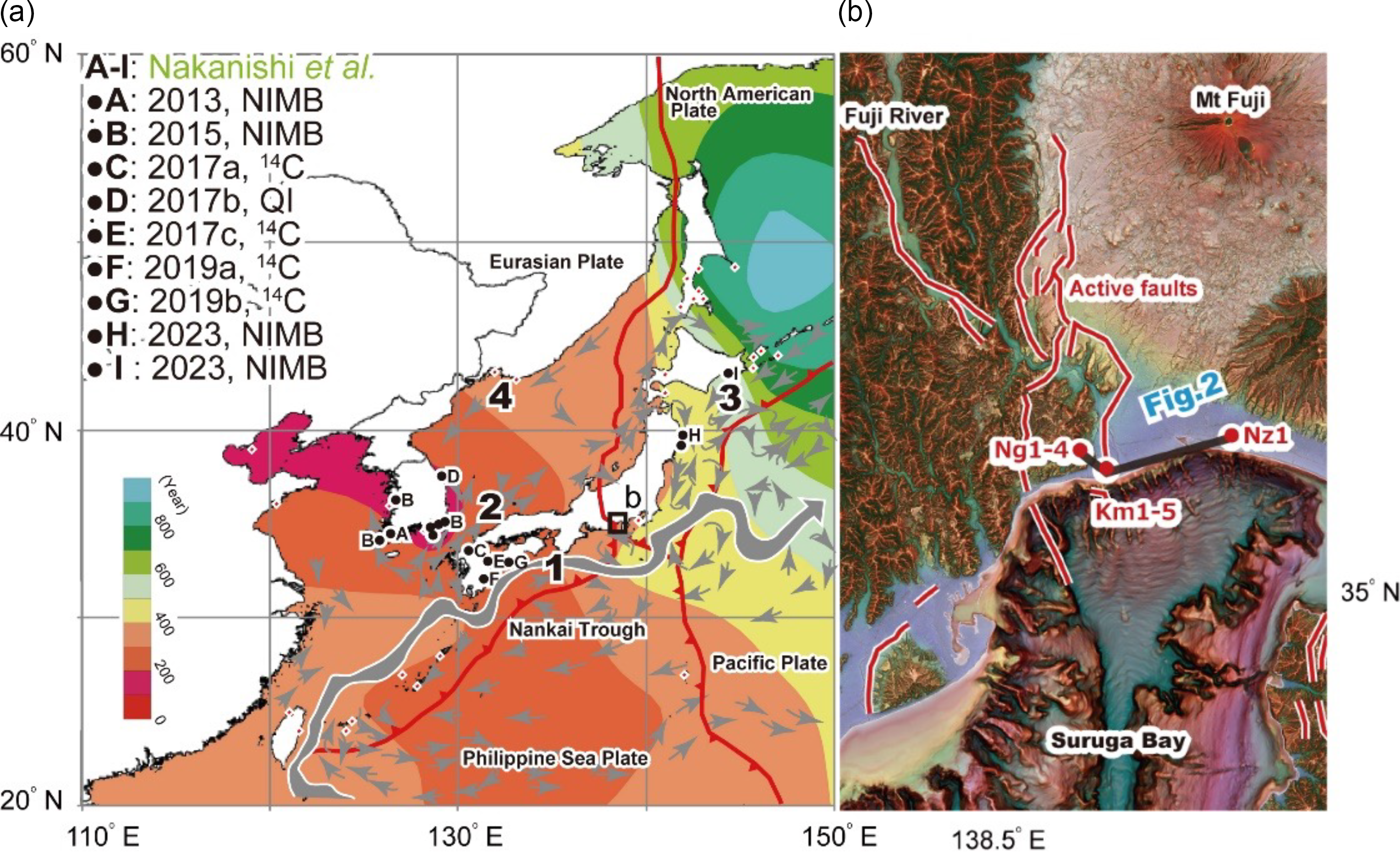
The Nankai Trough, which marks the boundary between the Eurasian Plate and the Philippine Sea Plate, extends into the coastal plain between Suruga Bay and Mount Fuji (Figure 1a; Matsuda Reference Matsuda1978; Yamazaki Reference Yamazaki1992; Ishiyama et al. Reference Ishiyama, Sato, Hirouchi, Matta, Tajikara, Ito, Kano and Yamamoto2020). The Iriyamase Fault, reverse faults that form middle part of the Fujikawa-kako Fault Zone (Yamazaki et al. Reference Yamazaki, Shimokawa, Mizuno and Tanaka2002), extend approximately 45 km from north to south and about 17 km from east to west. It intersects the historic Tokaido route, which once connected Kyoto (the former capital) and Edo (present-day Tokyo), two of Japan’s major cities. Even today, this corridor remains a critical transportation route, traversed by both the Tomei Expressway and the Tokaido Shinkansen.
(a) Study sites and modern marine reservoir ages in East Asia (modified after Nakanishi et al. 2015). Red dots from the Marine Reservoir Database. The contour lines are illustrated using the Kriging method with the Surfer 8 code (Golden Software, Colorado, USA). 1, Kuroshio Current; 2, Tsushima Current; 3, Oyashio Current; 4, Liman Current. (b) Geomorphology around the Suruga Bay. Base map is the red relief image map by Asia Air Survey Co., Ltd.

Between 2017 and 2020, the Ministry of Education, Culture, Sports, Science and Technology of Japan conducted studies on the Holocene record of paleoseismic events to support long-term assessments of future seismic hazards. To obtain geological data related to the Iriyamase Fault, sediment cores Ng-1 to 5, Km-1 to 5, and Nz-1 were collected across the fault. Analysis included sedimentary facies, radiocarbon (14C) ages, and mollusk assemblages. Based on these data, we provide an overview of changes in depositional environments and sedimentation rates.
Paired 14C age of shell and plant remains were obtained from the Nz-1 core. To evaluate temporal variations in the marine reservoir effect under the influence of the Kuroshio Current—a warm, north-flowing ocean current along the western side of the North Pacific—the results were compared with those from other studies conducted along the path of the Kuroshio Current’s path (Nakanishi et al. Reference Nakanishi, Takemura, Matsuyama, Shimoyama, Hong and Okuno2017a Reference Nakanishi, Hong, Shimoyama, Sato, Park and Lee2017b, Reference Nakanishi, Tsuji, Nanayama, Yamaguchi, Kondo, Ikeda and Hong2019a Reference Nakanishi, Hong, Kuwahata, Sugiyama, Shimoyama, Ohkushi, Yamaguchi, Park, Park and Nanayama2019b; sites C, E–G in Figure 1a).
Methods
Drilling sites
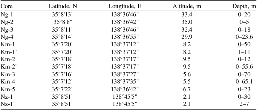
Ten sediment cores, ranging in length from 5 to 70 m, were drilled along an approximately 11 km east-west survey line extending from Nakanogo in Fuji City—located on a Holocene terrace on the west bank of the Fuji River—to Nakazato in Fuji City, situated on reclaimed land on the east bank, outside the river’s influence. Core names, coordinates, elevations, and drilling depths are listed in Appendix 1.
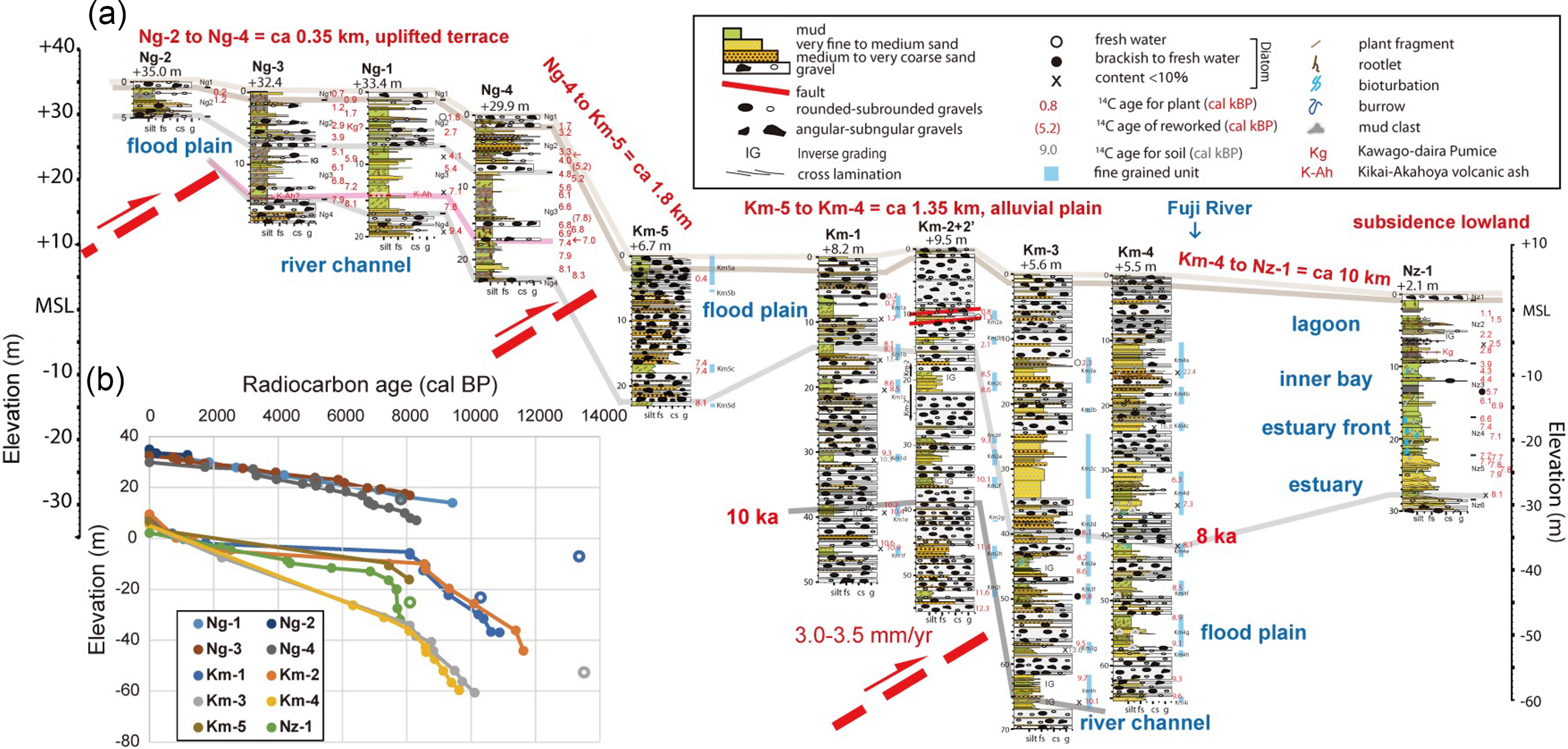
First, along an approximately 350 m east-west transect on the eastward-sloping terrace between +35 to +29 m, the following cores were collected from west to east: Ng-2 (35.0 m elevation, 5 m length), Ng-3 (32.4 m elevation, 18.0 m length), Ng-1 (33.4 m elevation, 20.0 m length), and Ng-4 (29.9 m elevation, 23.6 m length).
Next, approximately 1.8 km southeast of this transect, in Kambara, Shimizu Ward, Shizuoka City—on the coastal plain along the west bank of the Fuji River mouth—additional cores (Km-1 to Km-5) were drilled along a ∼1350 m east-west transect. From west to east, these cores were: Km-5 (6.7 m elevation, 23.0 m length), Km-1 (8.2 m elevation, 50.0 m length), Km-2 (9.5 m elevation, 55.6 m length), Km-3 (5.6 m elevation, 70.0 m length), and Km-4 (5.5 m elevation, 65.1 m length). Cores Km-3 and Km-4 were positioned on the subsidence side of the Iriyamase Fault, where the vertical slip rate is estimated to be 5.1–6.3 mm/yr (Maruyama Reference Maruyama2017). Approximately 600 m north of the Km-3 drilling site lies Kambara Earthquake Hill, uplifted during the 1853 Tokai Earthquake (Omori Reference Omori1919). The topography on the west side, corresponding to the uplifted block, slopes gently westward, opposite to the flow direction of the Fuji River. During the drilling of Km-1 and Km-2 cores, alternative boreholes were made at nearby locations due to sample loss and prolonged drilling times.
Additionally, the Nz-1 core (30 m in length) was drilled approximately 10 km northeast of the above transects, on reclaimed land at an elevation of +2.1 m, in an area unaffected by the influence of the Fuji or Urui Rivers. Due to partial sample loss, re-drilling was conducted to obtain supplementary samples. Previous studies—Hatano et al. (Reference Hatano, Tsuzawa and Matsushima1979), Matsubara (Reference Matsubara1984, Reference Matsubara1989), Yonekura et al. (Reference Yonekura, Ikeda, Kashima and Matsubara1985), Fujiwara et al. (Reference Fujiwara, Sawai, Morita, Komatsubara and Abe2007, Reference Fujiwara, Irizuki, Sampei, Haruki, Tomotsuka and Abe2008), and Komatsubara et al. (Reference Komatsubara, Shishikura and Okamura2007)—investigated paleoenvironmental changes in this region using borehole and survey data, which were referenced to infer the depositional environment of the Nz-1 core.
Sedimentological and paleontological analyses
To determine the sedimentary environments of ten cores, the lithologies, lithological boundaries, sedimentary structures, grain sizes, colors, fossil components, diatom fossil assemblages, 14C ages, and volcanic ash analyses were investigated in split cores.
The composition of diatom fossil assemblages was analyzed by Palynosurvey Co., Ltd. for a total of 25 samples from the Ng-1, Km-1 to 4, and Nz-1 cores. Mud layers were sampled from the surfaces of halved core specimens at horizons without deformation structures or bioturbation, excluding core boundaries (Figure 2a). The analysis procedure was conducted as follows: approximately 3 g of semi-dry sample were collected from the halved core surface and placed in a beaker for drying. The dried sample was weighed, then washed with 10% H2O2 and 1N HCl solutions. The supernatant was discarded until the solution reached neutral pH. The residue was then dropped onto a cover glass, dried, and mounted using Pleurax embedding medium to prepare slides. The slides were examined under an oil-immersion microscope at magnifications of 600 to 1000x. More than 200 diatom fossils were identified and counted for each sample. Diatom identification and ecological information were referenced primarily from Round et al. (Reference Round, Crawford and Mann1990).
(a) Geological cross across the Fujikawa-kako Fault Zone. (b) Accumulation curves of the Ng-1 to 4, Km-1 to 5 and Nz-1 cores. Ages of open symbols were interpreted as reworked samples.

Additionally, to improve the understanding of the sedimentary environments, mollusk assemblages of the Nz-1 core were identified according to the classification of Okutani (Reference Okutani2017).
Accelerator mass spectrometry 14C dating
To investigate the formation ages of the strata, 14C dating using accelerator mass spectrometry (AMS) was conducted on a total of 119 samples at the Korea Institute of Geoscience and Mineral Resources (KIGAM) and Beta Analytic Inc. (BETA). Sediments containing plant fragments and shell fossils were washed using a stainless steel sieve with a 2-mm mesh.
In horizons where multiple types of plant fragments were mixed in organic mud layers, ultrasonic cleaning was performed to separate the fragments by type, after which fine roots were removed, and fresh fragments were selected. Priority was given to fragile plant fragments such as leaves and small twigs, which undergo annual renewal. In cases where plant fragments were absent, the organic soil was acid-treated, and the residue was used for dating. Filter feeders and whole shells were preferentially selected over scavengers, deposit feeders, herbivores, unclassified species, and shell fragments. Plant and shell fragments were carefully washed with distilled water and an ultrasonic cleaner. Surface contaminants of plant samples were removed by repeating acid-alkali-acid treatments at 60 °C using 1N hydrochloric acid and sodium hydroxide solutions until no further soluble material was extracted. Calcareous marine samples were cleaned using a mild acid treatment and then powdered with a mortar and pestle.
At KIGAM, chemically treated samples were combusted using an elemental analyzer, and CO2 was extracted and converted to graphite using an automated reduction system (Hong et al. Reference Hong, Park, Kim, Woo, Kim, Choi and Kim2010a). Standard materials, including oxalic acid (OXII) from the National Institute of Standards and Technology and reference materials (C7 and C8) from the International Atomic Energy Agency (IAEA), were processed in the same manner for graphite preparation. Radiocarbon-free wood samples obtained from beneath the Aso-4 pyroclastic flow deposits, along with IAEA C-1, were treated similarly treated as blanks.
The carbon isotope ratios of these samples were measured using KIGAM’s AMS system (Hong et al. Reference Hong, Park, Sung, Woo, Kim, Choi and Kim2010b) to calculate 14C ages. Isotopic fractionation corrections were made using δ13C values measured by AMS. Calibration of radiocarbon ages to calendar years was performed using CALIB 8.2 (Stuiver and Reimer Reference Stuiver and Reimer1993; Stuiver et al. Reference Stuiver, Reimer and Reimer2022) and IntCal20 (Reimer et al. Reference Reimer, Austin, Bard, Bayliss, Blackwell, Bronk Ramsey, Butzin, Cheng, Edwards, Friedrich, Grootes, Guilderson, Hajdas, Heaton, Hogg, Hughen, Kromer, Manning, Muscheler, Palmer, Pearson, van der Plicht, Reimer, Richards, Scott, Southon, Turney, Wacker, Adolphi, Buntgen, Capano, Fahrni, Fogtmann-Schulz, Friedrich, Kohler, Kudsk, Miyake, Olsen, Reinig, Sakamoto, Sookdeo and Talamo2020). Reservoir ages were determined based on the 14C age offsets between pairs of terrestrial plant remains and marine shells collected from the same horizons of the Nz-1 core.
Results
Based on analyses of lithology, molluscan assemblages, and 14C dating, the cores were classified into six sedimentary facies. In ascending order, they are river channel, floodplain, estuary, estuary front, inner bay, and lagoon. These lithofacies are described below, along with remarks, depositional environments, and ages of the facies. The geologic cross section and age/core depth diagrams are provided in Figure 2a,b. The sedimentary facies differ in the Nakanogo (Ng-1 to 4 cores), Kambara (Km-1 to 5 cores), and Nakazato (Nz-1 core) areas, so they are described individually below.
Sedimentary facies of Nakanogo (Ng-1 to 4 cores)
Based on the observations of the Ng-1 to 4 cores, four sedimentary units (Ng1 to 4) were identified from top to bottom (Figure 2a). Diatom fossil assemblage analyses of Ng-1 core and 14C dating were conducted for all units except Ng1, which comprises an anthropogenically influenced gravelly sand layer. Additionally, preliminary analyses of grain composition and refractive indices were performed on volcanic ash layers identified in certain sections. The characteristics of Ng2 to 4 are described below, followed by an overview of their depositional environments and formation ages.
Ng2 consists of alternating mud layers containing plant fragments and interbedded gravel and sand layers, yielding 13 ages of 0.2 to 5.2 cal kBP. At a depth of approximately 5 m in the Ng-3 core, fibrous volcanic glass–indicative of the Kawago-daira Pumice (Kg; Nishida et al. Reference Nishida, Takahashi, Takemura, Ishida and Maeda1993, Machida and Arai Reference Machida and Arai2003)–was observed. This pumice has been dated to 3137–3160 cal BP (Tani et al. Reference Tani, Kitagawa, Hong, Park, Sung and Park2013). The sand and gravel layers become more frequent in the lower part and exhibit upward fining trends with thicknesses of several tens of centimeters. These characteristics suggest a gradual environmental transition from small-scale river channels to floodplain conditions.
Ng3 comprises interbedded mud and sand layers containing plant fragments and roots, with 23 ages of 4.1 to 8.3 cal kBP. Around a depth of 14 m in the Ng-1 and 3 cores, volcanic glass with bubble-wall structures, indicative of the Kikai-Akahoya tephra (K-Ah; Machida and Arai Reference Machida and Arai2003; 7165–7303 cal BP, Smith et al. Reference Smith, Staff, Blockley, Bronk Ramsey, Nakagawa, Mark, Takemura and Danhara2013), was abundantly observed. The 14C ages and glass refractive indices were found to be consistent. Plant fragments are more abundant in the lower part, while sand layers increase toward the upper part, indicating a gradual transition from peat-rich wetland environments to small-scale rivers and floodplains.
Ng4 predominantly consists of interbedded gravel and sand layers, with thin mud layers containing plant fragments yielding 3 ages of 7.9 to 9.4 cal kBP. The unit shows an overall upward coarsening trend, with gravel layers only appearing at the very top, with thicknesses of several tens of centimeters. This suggests the progressive encroachment of small-scale river channels into the depositional environment.
Sedimentary facies of Kambara (Km-1 to 5 cores)
Based on the observations of five cores (Km-1 to 5) across the Iriyamase Fault (Figure 2a), the sediments were classified into two primary units: (1) gravel-dominated units and (2) fine-grained units composed mainly of sand and mud layers. Diatom fossil assemblage analysis and 14C dating were conducted on mud layers within the fine-grained units. The 14C ages from plant fragments were mostly (2/108 = 98%) consistent with the stratigraphic relationships in all cores, while soil samples yielded conflicting results, typically showing more than 1000 years older ages than those of plant fragments (Figure 2). Therefore, only the dates from plant fragments were used in subsequent discussions.
The gravel-dominated units range in thickness from 1 to 13 m and generally exhibit upward fining. They primarily consist of sub-rounded to sub-angular gravel with diameters of 2 to 150 mm, composed of andesite, tuff, metamorphic rocks, and sedimentary rocks, accounting for more than half of the entire core sequences. Similar gravel layers are observed along the present-day Fuji River banks and Pleistocene outcrops near the river (Shiba et al. Reference Shiba, Okubo, Kasahara, Yamamoto and Kobayashi1990). These deposits likely formed in river channels dominated by traction transport (Miall Reference Miall1977, Reference Miall, Walker and James1992). In contrast, the fine-grained units are subdivided into subunits a to i from top to bottom in each core. These units comprise six layers in Km-1, nine in Km-2, eight in Km-3, and nine in Km-4, and four in Km-5. On the fault’s uplift side (Km-1 and 2 cores), the layers are thinner (<3 m) than those on the subsidence side and are dominated by fine-grained mud particles, frequently containing plant fragments and roots. On the subsidence side, thick sand layers, such as Km3c (∼10 m) and Km4d (∼7 m), were observed along with mud crusts, cross-bedding structures, and burrows or bioturbation traces (Frey and Pemberton Reference Frey, Pemberton and Walker1984; Pemberton et al. Reference Pemberton, MacEachern, Frey, Walker and James1992) in Km3e, Km3g, Km4a, Km4d, and Km4e. Diatom fossils in the mud layers were sparse but predominantly freshwater species, with occasional brackish to freshwater taxa. Flood deposits with inverse grading structures (Masuda and Iseya Reference Masuda and Iseya1985) were observed in Km1e, Km3e, and Km3h.
Sedimentary facies of Nakazato (Nz-1 core)
Based on observations of the Nz-1 core sediments, five depositional units (Nz2 to 6) were identified from the top down (Figure 2a). Diatom fossil assemblage analysis and 14C dating were conducted for all units except for Nz1, which consists of artificial fill comprising sand and gravel. Below, the characteristics of units Nz2 to 6 are described, followed by an overview of the depositional environment and formation ages.
The Nz2 unit consists of interbedded mud and sand layers containing plant fragments and roots, with 5 ages of 1.1 to 2.8 cal kBP. Occasional gravel and scoria layers were observed, potentially correlating with the repeated transitions from peat to mud layers and scoria reported by Fujiwara et al. (Reference Fujiwara, Sawai, Morita, Komatsubara and Abe2007, Reference Fujiwara, Irizuki, Sampei, Haruki, Tomotsuka and Abe2008). Around a depth of 8 m, volcanic glass of fiber type—indicative of the Kg—was also observed. The abundant plant roots and organic deposits suggest a lagoon to wetland environment. However, given that these strata, which formed near present sea level, are now found at elevations between 0 m and –7 m, it is likely that subsidence due to tectonic movements has affected the area (Fujiwara et al. Reference Fujiwara, Irizuki, Sampei, Haruki, Tomotsuka and Abe2008; Matsubara Reference Matsubara1989).
The Nz3 unit is predominantly composed of mud layers containing plant fragments, shell fossils, burrows, and evidence of bioturbation. Prodeltaic molluscan species, such as Ringicula doliaris (Gould 1860), were scattered within this unit. Thin sand layers (∼several tens of centimeters thick) are occasionally interbedded. Six ages of 3.9 to 6.9 cal kBP were obtained from plant and shell fragments in this unit. The predominance of mud transported by suspension, along with the presence of shells and burrows, suggests deposition in a sheltered inner bay environment.
The Nz4 unit consists of interbedded mud and sand layers with frequent occurrences of plant fragments, shell fossils, burrows, and bioturbation traces. Three ages of 6.6 to 7.4 cal kBP were obtained from plant and shell fragments in this unit. The facies included subtidal mollusks, such as Macoma tokyoensis (Makiyama 1927). The unit exhibits an overall fining-upward trend, indicating formation during a transitional period from a sandbar-dominated environment to the previously described estuary front environment.
The Nz5 unit is primarily composed of upward-fining sand layers with cross-bedding structures at the base. Occasional occurrences of burrows, shell fossils, and plant fragments were observed. The unit included subtidal molluscan species, such as M. tokyoensis, and lower intertidal to subtidal species, such as Phacosoma japonicum (Reeve 1850). Severn ages of 7.7 to 8.1 cal kBP were measured from plant and shell fragments in this unit. The fining-upward sequence, combined with the increased presence of shell fossils and burrows toward the upper layers, suggests deposition in an estuarine environment during a period of rising sea levels.
The Nz6 unit consists of interbedded gravel and sand layers with sparse occurrences of shell fossils. The unit shows an overall fining-upward trend, with occasional shell fossil occurrences, suggesting deposition as channel sediments during the initial stages of sea-level rise.
Discussion
Holocene activity of the Iriyamase Fault
Based on the results of sedimentological analysis of the Km-1 to 5 cores, we inferred the depositional environment and formation ages of the Holocene sediments across the fault zone and estimated the fault’s activity periods, recurrence intervals, and average displacement rates. Plant fragments from Km1e and Km2f, at an elevation of –30 to –35 m, yielded three ages of 10.1 to 10.4 cal kBP, indicating that fine-grained units on the uplift side formed under freshwater conditions (Figure 2a). On the subsidence side, plant fragments from Km3h at approximately –60 m yielded two ages of 9.7 to 10.1 cal kBP. The vertical offset across the Iriyamase Fault suggests the vertical slip rate at least 3.0 to 3.5 mm/yr because these fine-grained units were formed horizontally on a floodplain.
The depositional curves obtained from the uplifted (Km-1 to 2, and 5 cores) and subsiding (Km-3 to 4 cores) sides of the Iriyamase Fault tend to diverge more significantly in older strata (Figure 2b). The depositional curves from lowland area approximately 10 km away (Nz-1 core) exhibit an intermediate trend between these curves. This clearly indicates that near the reverse fault, older strata have undergone greater vertical displacement due to repeated episodes of vertical movement. Similar cumulative increases in the difference between sedimentation curves across active faults have been reported in the Tokushima and Niigata plains (Nakanishi et al. Reference Nakanishi, Takemura, Okada, Morino, Hayashida, Nakamura, Tazawa, Ogino, Matsumoto and Hirose2004, Reference Nakanishi, Miyachi, Tanabe, Urabe, Yasui and Wakabayashi2010).
The presence of burrows and bioturbation traces at the Km3e, Km4a, d and e suggests that fine-grained units formed in coastal environments. The greater thickness and more numerous layers of fine-grained units on the subsidence side indicate that fault-related subsidence created accommodation space subsequently filled by sediment. Future research will involve quantitative analyses using diatom fossils and plant fragments to refine depositional environment reconstructions and correlate formation ages between the uplift and subsidence sides. The current data suggest similar ages (8.2 to 8.6 cal kBP) for Km1c and Km2c on the uplift side and Km3e and Km4f on the subsidence side, indicating that cumulative fault displacements are recorded between the Km2 and Km3 cores, where a small surface scarp is present (Figure 2a).
The Holocene deposits, which form the terraces, are 19 to 24 m thick (Ng-1, Ng-3, and Ng-4 cores), despite being located on the uplifted side of the Iriyamase Fault. The depositional curves exhibit no significant hiatuses of 6.4 to 7.4 thousand years, such as those observed between Km1a and Km1b, or between Km2b and Km2c, indicating stable sedimentation conditions. To maintain such stable depositional environments, the presence of a branched thrust fault at the boundary between the terrace surface and the mountain slope is inferred. The notable difference in the thickness of Holocene deposits between the Ng-2 and Ng-3 cores may reflect the activity of this fault. Furthermore, evidence suggests the existence of a branch fault that uplifts the terrace surface at the terrace scarp’s edge between the Ng-4 and Km-5 cores. Similar thrust faults with multiple splay structures have been reported in the Kuwana Fault and other comparable geological settings (Ishiyama et al. Reference Ishiyama, Mueller, Togo, Okada and Takemura2004).
In Km2a, distinct high-angle boundaries were identified: two between gravel and mud layers, one between sand and mud layers, and one between sand and gravel layers. Near these boundaries, thin, inclined sand layers were observed in the mud layers, along with brown oxidized zones in the upper parts. These features suggest the formation of small faults due to fault activity. Two ages of 0.8 to 1.3 cal kBP were obtained from the deformed mud layer in Km2a, indicating fault activity occurred after this period.
Marine reservoir ages
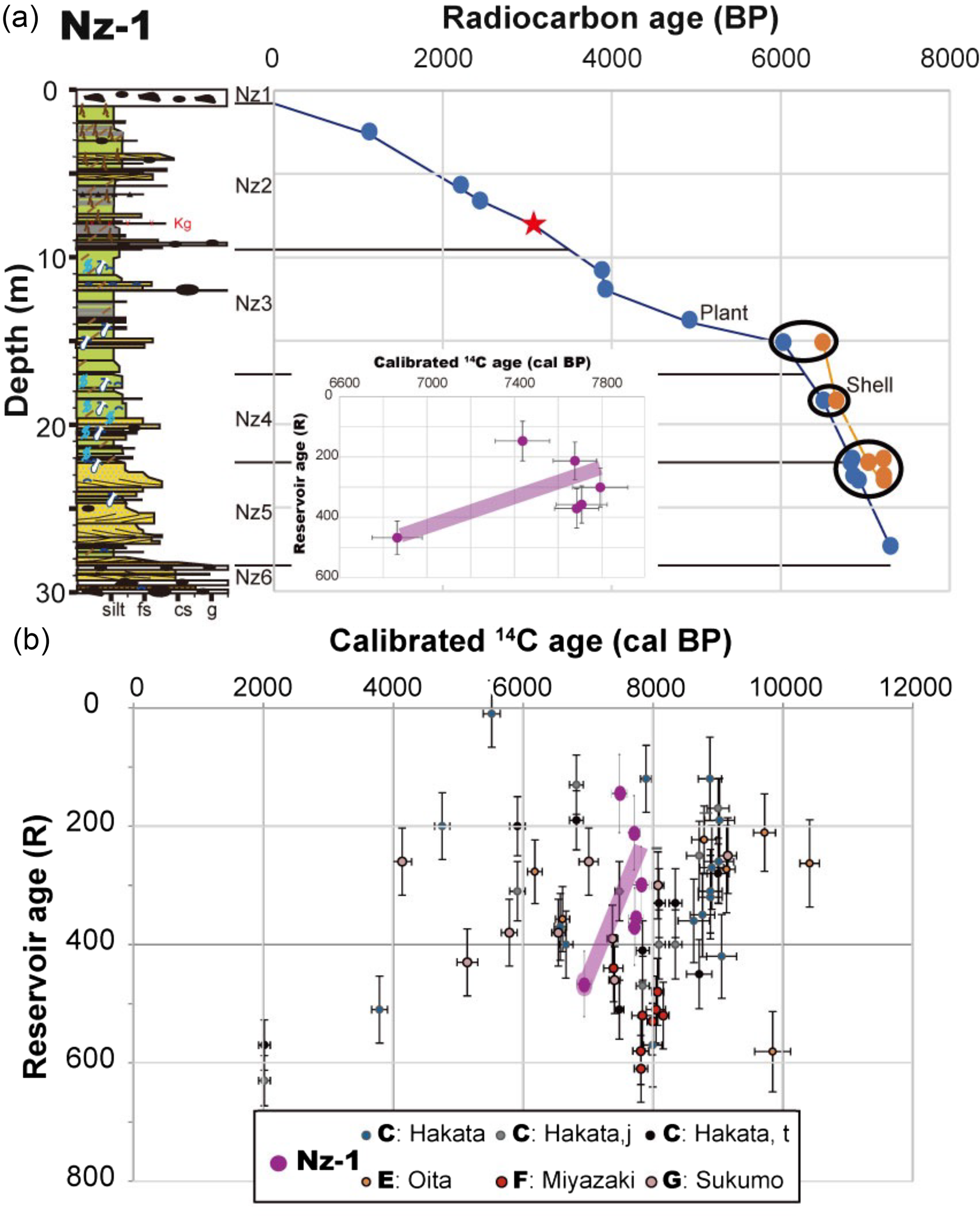
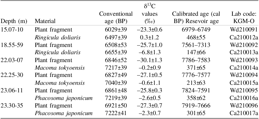
Six offsets in the 14C ages between pairs of terrestrial plant remains and marine shells, which were caused by the reservoir effect, were calculated from the same horizons of the Nz-1 core, ranging from 6800 to 7900 cal BP (Figure 3a and Appendix 2). The calculated reservoir ages (R) ranged from 150 ± 70 to 470 ± 60 14C years, with an average of 310 ± 120 14C years. This result of the R values from the Suruga Bay was comparable with previously determined values, such as an average of 310 ± 130 14C years (n = 8; Nakanishi et al. Reference Nakanishi, Takemura, Matsuyama, Shimoyama, Hong and Okuno2017a; E in Figures 1a and 3b), ranging from 210 ± 70 to 580 ± 70 14C years, which were obtained from the Oita Plain, from 6180–10,410 cal BP. Moreover, these values are similar to an average of 310 ± 150 14C years (n = 33) and 300 ± 70 14C years (n = 8) that were obtained from the Hakata Bay during 2000–9000 cal BP (Nakanishi et al. Reference Nakanishi, Hong, Shimoyama, Sato, Park and Lee2017b; C in Figures 1a and 3b) and the Sukumo Plain during 4100–9200 cal BP (Nakanishi et al. Reference Nakanishi, Hong, Kuwahata, Sugiyama, Shimoyama, Ohkushi, Yamaguchi, Park, Park and Nanayama2019b; G in Figures 1a and 3b), respectively. In contrast to these inconsistencies, the Miyazaki Plain, which is also influenced by the Kuroshio Current, has been reported to have an average R value of 530 ± 50 14C years, ranging from 440 ± 60 to 610 ± 60 14C years during 7300–8200 cal BP (n = 8; Nakanishi et al. Reference Nakanishi, Hong, Shimoyama, Sato, Park and Lee2017b; F in Figures 1a and 3b). These discrepancies reflect the complexity of the marine reservoir effect, and indicate the need to carefully consider its spatial and temporal changes. The temporal change of the marine reservoir effect in the Suruga Bay shows an intermediate trend in the R values compared to those obtained from other coastal areas under the Kuroshio Current (Figures 3b).
(a) Accumulation curves and reservoir ages of the Nz-1 core. Black lines denote the boundary of the sedimentary facies. Ages and lines of blue and orange were from terrestrial and marine samples, respectively. (b) Reservoir ages under the Kuroshio Current. C and E-G were measured by Nakanishi et al. (Reference Nakanishi, Takemura, Matsuyama, Shimoyama, Hong and Okuno2017a Reference Nakanishi, Hong, Shimoyama, Sato, Park and Lee2017b, Reference Nakanishi, Tsuji, Nanayama, Yamaguchi, Kondo, Ikeda and Hong2019a, Reference Nakanishi, Hong, Shimoyama, Sato, Park and Lee2017b) (Figure 1a).

Conclusions
Arrayed drilling survey conducted around the Fujikawa River Mouth Fault Zone, located across the northern extension of the Nankai Trough, yielded the following findings:
-
1. Identification of Interbedded Units: Group drilling surveys near the low fault scarp identified interbedded sand-gravel and fine-grained sediment units.
-
2. Evidence of the Latest Faulting Event: A mud layer dated to 0.8–1.3 cal kBP near the fault scarp was found to have deformed by the most recent faulting event.
-
3. Vertical Displacement Rate Estimation: Based on elevation differences in floodplain deposits dated to 10.1–10.4 cal kBP, vertical displacement rates at least 3.0 to 3.5 mm/year were estimated.
-
4. Existence of Splay Faults: The thick Holocene deposits beneath the terraces suggest that splay faults are concealed at the boundary between the mountain and the terrace surface and at the terrace scarp.
-
5. Marine Reservoir Ages: An average R value of 310 ± 120 14C years, ranged from 150 ± 70 to 470 ± 60 14C years, was calculated during 6800–7900 cal BP.
Further detailed analyses of depositional environments and chronological data are expected to provide insights into regional crustal deformation and paleoseismic events.
Acknowledgments
This manuscript was improved by constructive comments from two anonymous referees and editors. The authors thank Drs. Tomoo Echigo and Tatsuya Shibata for their support for the cores sampling. Thess cores were obtained by the Headquarters for Earthquake Research Promotion at the Japanese Ministry of Education, Culture, Sports, Science and Technology. A part of the radiocarbon dating was partially funded by the JSPS Kakenhi grant numbers JP18H01310 and JP22K18304. This research was partly supported by the Basic Research Project of the Korea Institute of Geoscience and Mineral Resources (KIGAM) funded by the Ministry of Science and ICT.
Location and depth of drilling core sites in this study.

Appendix 1 Long description
A table detailing the location and depth of drilling core sites. The table has 15 rows and 5 columns. The columns are labeled Core, Latitude, N, Longitude, E, Altitude, m, and Depth, m. Each row provides specific data for different core sites. Row 1: Core Ng-1, Latitude 358'13", Longitude 13836'46", Altitude 33.4 meters, Depth 0-20 meters. Row 2: Core Ng-2, Latitude 358'8", Longitude 13836'42", Altitude 35.0 meters, Depth 0-5 meters. Row 3: Core Ng-3, Latitude 358'11", Longitude 13836'46", Altitude 32.4 meters, Depth 0-18 meters. Row 4: Core Ng-4, Latitude 358'14", Longitude 13836'55", Altitude 29.9 meters, Depth 0-23.6 meters. Row 5: Core Km-1, Latitude 357'20", Longitude 13837'12", Altitude 8.2 meters, Depth 0-50 meters. Row 6: Core Km-1', Latitude 357'20", Longitude 13837'12", Altitude 8.2 meters, Depth 1-11 meters. Row 7: Core Km-2, Latitude 357'18", Longitude 13837'17", Altitude 9.5 meters, Depth 0-12 meters. Row 8: Core Km-2', Latitude 357'18", Longitude 13837'17", Altitude 9.5 meters, Depth 0-55.6 meters. Row 9: Core Km-3, Latitude 357'16", Longitude 13837'27", Altitude 5.6 meters, Depth 0-70 meters. Row 10: Core Km-4, Latitude 357'12", Longitude 13837'35", Altitude 5.5 meters, Depth 0-65.1 meters. Row 11: Core Km-5, Latitude 357'22", Longitude 13836'42", Altitude 6.7 meters, Depth 0-23 meters. Row 12: Core Nz-1, Latitude 358'51", Longitude 13845'5", Altitude 2.1 meters, Depth 0-30 meters. Row 13: Core Nz-1', Latitude 358'51", Longitude 13845'5", Altitude 2.1 meters, Depth 2-7 meters.", "EDH": "
Radiocarbon ages and reservoir ages from the Nz-1 core.

Appendix 2 Long description
A table comparing radiocarbon ages and reservoir ages from the Nz-1 core. The table has 8 rows and 7 columns. The columns are labeled Depth (m), Material, Conventional age (BP), δ13C values (‰), Calibrated age (cal BP), Reservoir age, and Lab code: KGM-O. Row 1: Depth 15.07-10, Material Plant fragment, Conventional age 6029±39, δ13C values -23.3±0.6, Calibrated age 6979-6749, Reservoir age none, Lab code Wd210091. Row 2: Depth 15.07-10, Material Ringicula doliaris, Conventional age 6497±39, δ13C values 0.3±1.2, Calibrated age 468±55, Reservoir age none, Lab code Ca210012a. Row 3: Depth 18.55-59, Material Plant fragment, Conventional age 6508±53, δ13C values -25.7±1.0, Calibrated age 7561-7313, Reservoir age none, Lab code Wd210092. Row 4: Depth 18.55-59, Material Ringicula doliaris, Conventional age 6655±39, δ13C values -6.8±1.3, Calibrated age 147±66, Reservoir age none, Lab code Ca210013a. Row 5: Depth 22.03-07, Material Plant fragment, Conventional age 6846±52, δ13C values -30.1±1.3, Calibrated age 7786-7583, Reservoir age none, Lab code Wd210093. Row 6: Depth 22.03-07, Material Macoma tokyoensis, Conventional age 7217±39, δ13C values -0.2±0.9, Calibrated age 371±65, Reservoir age none, Lab code Ca210014a. Row 7: Depth 22.25-30, Material Plant fragment, Conventional age 6827±49, δ13C values -27.1±0.5, Calibrated age 7776-7577, Reservoir age none, Lab code Wd210094. Row 8: Depth 22.25-30, Material Macoma tokyoensis, Conventional age 7040±39, δ13C values -0.6±1.1, Calibrated age 213±63, Reservoir age none, Lab code Ca210015a. Row 9: Depth 23.06-11, Material Plant fragment, Conventional age 6861±48, δ13C values -25.8±0.3, Calibrated age 7824-7591, Reservoir age none, Lab code Wd210095. Row 10: Depth 23.06-11, Material Phacosoma japonicum, Conventional age 7219±39, δ13C values -2.6±0.5, Calibrated age 358±62, Reservoir age none, Lab code Ca210016a. Row 11: Depth 23.30-35, Material Plant fragment, Conventional age 6921±50, δ13C values -27.3±0.7, Calibrated age 7919-7666, Reservoir age none, Lab code Wd210096. Row 12: Depth 23.30-35, Material Phacosoma japonicum, Conventional age 7222±41, δ13C values -2.3±0.7, Calibrated age 301±65, Reservoir age none, Lab code Ca210017a.