
Introduction
Stonehenge is one of Europe's finest and most iconic prehistoric monuments. It stands on Salisbury Plain, in Wiltshire, some 15km north of Salisbury, and forms part of a complex of monuments in the ‘Stonehenge Landscape’, which is inscribed as a World Heritage Site. Over a period of about 1300 years, from around 3000 BC, Stonehenge was built, re-built and added to (for details, see Parker Pearson Reference Parker Pearson2015).
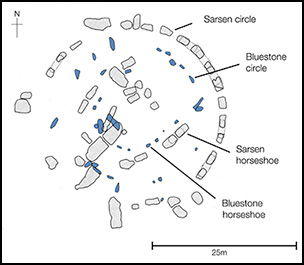
Stonehenge is perhaps best known for the large sarsen trilithons (orthostats with lintels), which make up the monument's outer circle and the outer horseshoe (see Figure 1); composed of a hard, durable type of sandstone known as silcrete, they reach up to 8m in height and weigh up to 30 tons. For centuries, the origin of these stones has been thought to be relatively local, most probably being derived from the Marlborough Downs area some 30km to the north of Stonehenge, and that is still the consensus today (see Parker Pearson Reference Parker Pearson2016a). Less prominent are the smaller stones that make up the inner circle and the inner horseshoe. These are the so-called bluestones, which reach a maximum height of 3m and which typically weigh between one and two tons. ‘Bluestone’ is the accepted term used for all non-sarsen stone employed as orthostats at Stonehenge, or found as their debitage in the Stonehenge Landscape, and it comprises a range of lithologies, including dolerites, rhyolitic tuffs, argillaceous tuffs and sandstones. There is evidence that these stones arrived and were erected at Stonehenge before the sarsen stones (as discussed in Parker Pearson Reference Parker Pearson2015).
Plan of Stonehenge showing the arrangements of the sarsens (grey) and bluestones (blue) in the two circles and two horseshoes. (Drawing by Jim Turner.)

There is a long history of research into the bluestones (for recent reviews, see Thorpe et al. Reference Thorpe, Williams-Thorpe, Jenkins, Watson, Ixer and Thomas1991; Bevins et al. Reference Bevins, Ixer and Pearce2014), and they have had a special significance in understanding Stonehenge, for it has long been recognised that they are ‘exotic’ to the Stonehenge area. Recent investigations by the present authors have called into question earlier hypotheses concerning the provenances of the ‘Preseli bluestones’, and have identified alternative sources for some of the orthostat and debitage bluestones at Stonehenge (Ixer & Bevins Reference Ixer and Bevins2011a; Bevins & Ixer Reference Bevins and Ixer2013; Bevins et al. Reference Bevins, Ixer and Pearce2014). In this paper we review the evidence presented previously in relation to their provenance, examining in detail the work of H.H. Thomas, whose Reference Thomas1923 paper has long been regarded, until recently, as the seminal work on the original sources of the Stonehenge bluestones.
Previous studies of the bluestones
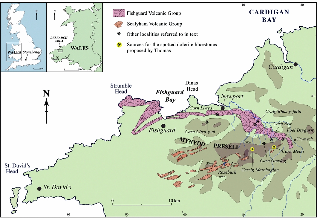
Thomas (Reference Thomas1923) recognised the so-called ‘spotted dolerites’ as coming from the Mynydd Preseli area in north Pembrokeshire, west Wales, citing Carn Menyn (now called Carn Meini) and Cerrig Marchogion as the principal sources of the doleritic bluestones. In addition, he considered that the rhyolitic bluestone component came from the nearby outcrop of Carn Alw, and that the ‘calcareous ash’ came from the northern slopes of Foel Trigarn (now called Foel Drygarn). Key locations referred to in this paper are presented in Figure 2, and the modern names for localities are used throughout.
Map of north Pembrokeshire showing the location of key sites referred to in the text and the extent of the major volcanic sequences in the area.

Since 2010, we have been re-examining the petrographical and mineralogical characteristics of all the Stonehenge bluestone lithologies in both transmitted and reflected light modes (see Ixer & Bevins Reference Ixer and Bevins2010, Reference Ixer and Bevins2011a & b, Reference Ixer and Bevins2013, Reference Ixer and Bevins2016; Bevins et al. Reference Bevins, Pearce and Ixer2011; Bevins & Ixer Reference Bevins and Ixer2013; Ixer et al. Reference Ixer, Bevins and Gize2015, Reference Ixer, Turner, Molyneux and Bevins2017), which has led to a major re-appraisal of the sources of the bluestones, with Craig Rhos-y-felin being identified as the principal source of the rhyolitic component of the debitage recovered to date from the Stonehenge Landscape (Ixer & Bevins Reference Ixer and Bevins2011a). We have also concluded that Carn Alw is demonstrably not a source of Stonehenge rhyolite, either as orthostats or as debitage (Bevins et al. Reference Bevins, Ixer, Webb and Watson2012; Bevins & Ixer Reference Bevins and Ixer2013), and nor are Carn Llwyd or Carn Clust-y-Ci (Bevins et al. Reference Bevins, Ixer, Webb and Watson2012). In a parallel study, based on new whole-rock geochemical data and a re-examination and re-appraisal of all previous analyses, Bevins et al. (Reference Bevins, Ixer and Pearce2014) have identified Carn Goedog as being the principal source of the Stonehenge doleritic orthostats and their debitage component. More recently, U-Pb age dating of rhyolite from Craig Rhos-y-felin and of a rhyolite debitage fragment from the May 2008 Stonehenge excavations has further established the link between Craig Rhos-y-felin and Stonehenge (Bevins et al. Reference Bevins, Atkinson, Ixer and Evans2017).
In summary, what our studies have done is to call into question many, if not most, of the assertions made by a number of the earlier investigators, but in particular those made by Thomas in his 1923 paper. Indeed, a close examination of that paper reveals numerous shortcomings. What this current paper focuses on are the conclusions reached by Thomas, appraising that work in the context of his geological career, tracking the period during which he was working in Wales and identifying the resources present throughout his investigations into the provenancing of the bluestone, not only in terms of fieldwork opportunities, but also in the amount and source of the rock material and the thin sections available to him.
The career of H.H. Thomas
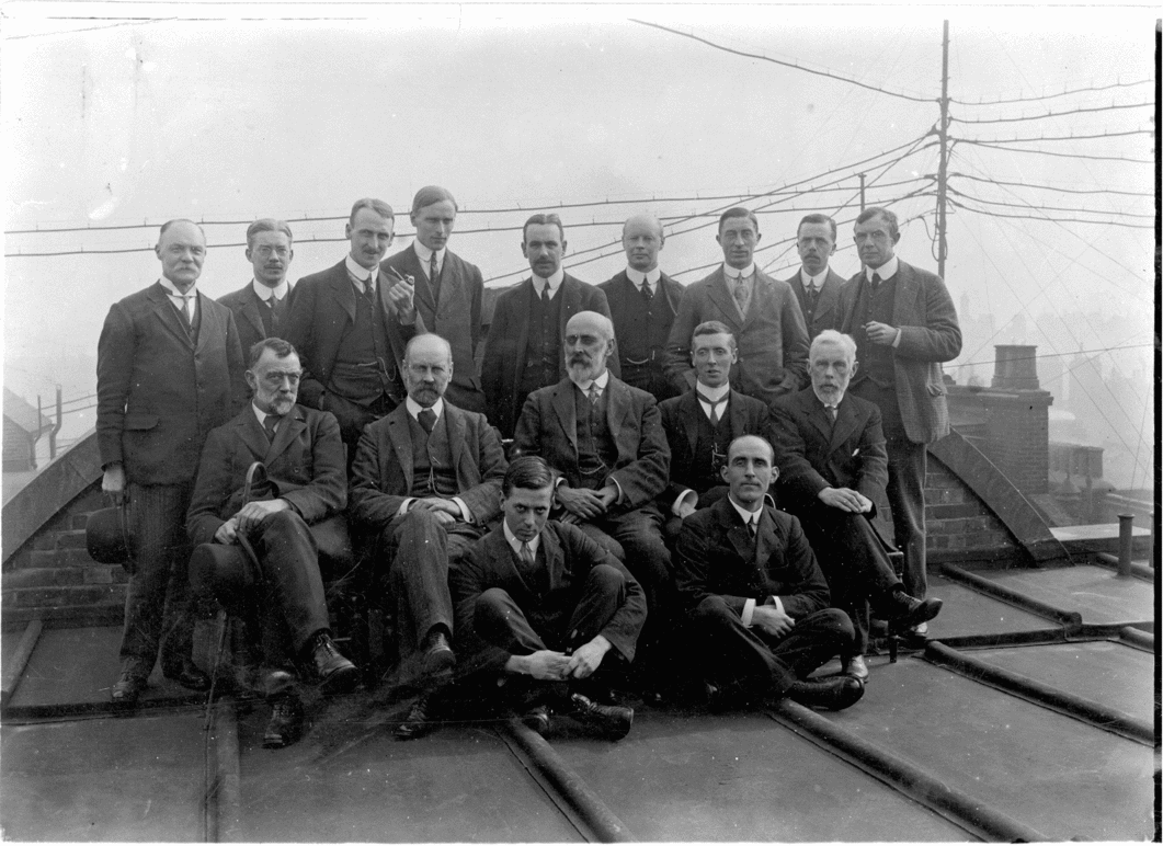
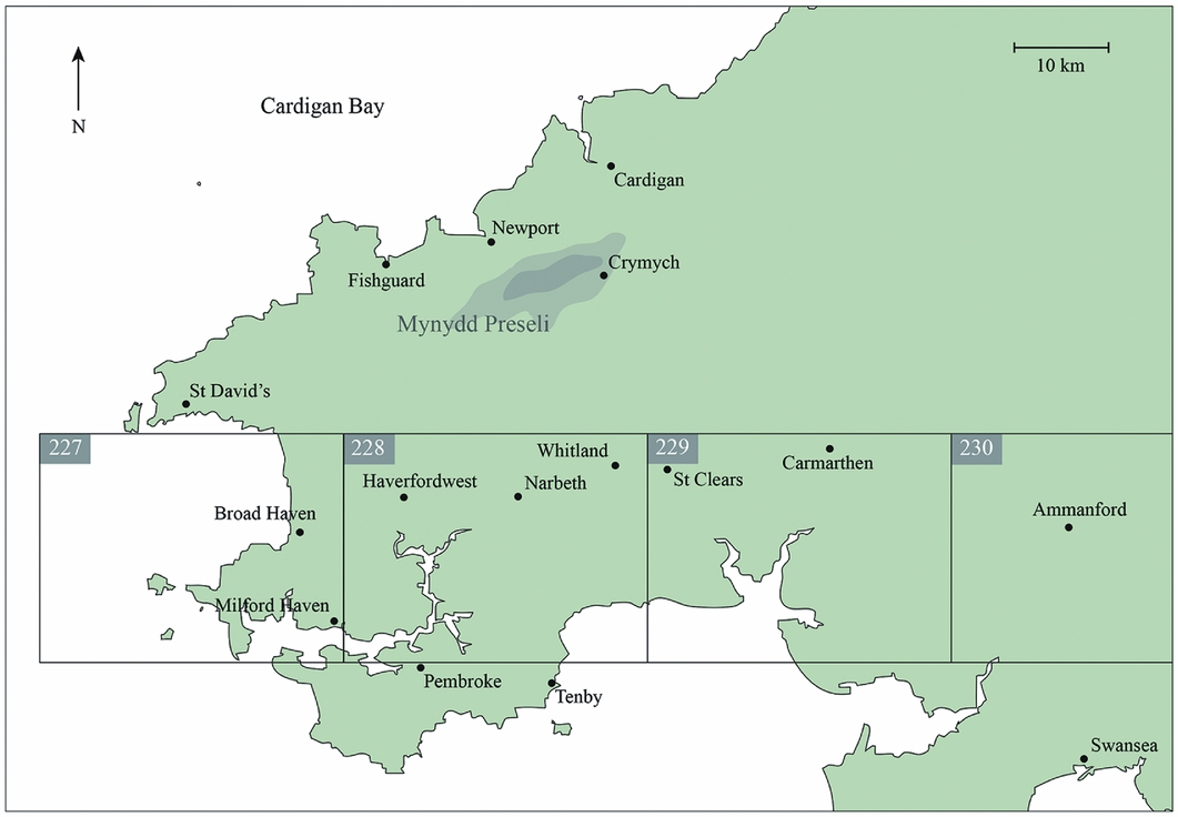
In 1901 Herbert Henry Thomas was appointed as Geologist for the Geological Survey (Figure 3), and joined a mapping team that was working on the Ammanford Sheet (sheet 230), in south Wales. From the Geological Survey's Summary of progress memoirs (Geological Survey of the United Kingdom 1902, 1903, 1904, 1905, 1906, 1907, 1908, 1909, 1910), we can see that he then worked subsequently on the sheets for Carmarthen (229), Haverfordwest (228) and Milford Haven (227) (see Figure 4), before being transferred to north Wales in 1910 to work on the Wrexham sheet. His time in north Wales was short, however, as in 1911 he was appointed as the Survey's petrographer, based in the Museum of Practical Geology in Jermyn Street in London, where he remained for the rest of his career.
H.H. Thomas (back row, fifth from left), along with other Geological Survey staff including O.T. Jones (back row, third from left) and E.E.L. Dixon (front row, right) who both worked with Thomas on mapping field areas in south Wales. (Copyright Natural Environment Research Council (NERC); reproduced with permission of the British Geological Survey, image P008712.)

Map showing the area that Thomas worked in and his role in mapping south Wales between 1901 and 1909 for the British Geological Survey. Numbers (227–230) on the map refer to the Geological Survey sheet number.

It was during the period 1903–1909 that Thomas gained his experience of working on the Lower Palaeozoic rocks of Carmarthenshire and southern Pembrokeshire, but crucially, for this review, not extending into the Mynydd Preseli. Indeed, as far as we can ascertain, Thomas's first-hand knowledge of the Mynydd Preseli might well have been restricted to a single, field collecting visit in 1906.
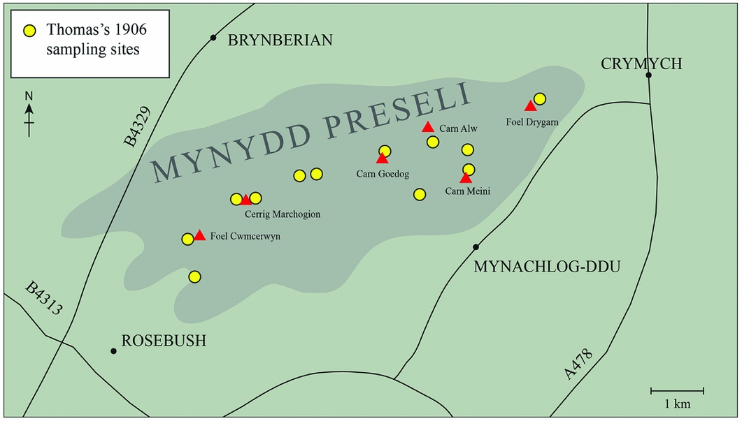
Some context for Thomas's knowledge and first-hand experience of the Mynydd Preseli and its geology is provided by details in an article published in 1966 in the Welsh language journal Y Gwyddonydd (the Scientist) by O.T. Jones, who worked with Thomas on mapping in south-west Wales. This mentions that ‘one Saturday’ in 1908 (although it was undoubtedly 1906; see below), the south Wales mapping team, comprising H.H. Thomas, O.T. Jones, T.C. Cantrill and E. Dixon, along with D.C. Evans, took the train from Clynderwen (south of the Preseli) up to Rosebush, a small slate-quarrying village near the summit of the Preseli. They climbed to the summit of Foel Cwm Cerwyn and then traversed the Preseli ridge to the east, eventually reaching the outcrop of Carn Meini before passing on to Foel Drygarn and descending to Crymych. The party recognised the distinctive spotted dolerite of Carn Meini as matching the erratic boulders found across the ground that they were mapping to the south, as far as the Narberth and Lampeter Velfrey area. That this excursion occurred in 1906 rather than 1908 is demonstrated by entries in the Geological Survey's ‘E Collection’ day book. A set of 15 samples, numbered E5705–E5719, were entered on (and hence collected before) 8 December 1906, and were attributed to H.H. Thomas. Note that there are no other Preseli specimens attributed to Thomas entered into the day book. The latitude/longitude coordinates attached to the specimens precisely mirror the route the geologists took on their Preseli excursion (Figure 5), from Rosebush in the west, traversing eastwards to Foel Drygarn, before descending to Crymych, as described in Jones (Reference Jones1966).
Map showing the location of samples collected by Thomas (yellow dots) on the 1906 field excursion in relation to the main Preseli localities referred to in the text (red triangles).

According to Jones (Reference Jones1966: 216), “some ten years after leaving Pembrokeshire, Thomas received a parcel”, possibly from Colonel Hawley or William Tapp, but certainly at the behest of the Society of Antiquaries (see below), “containing a large number of specimens with the request whether it was possible to discover where such stones were to be found [translation by D. Bassett]” (Jones Reference Jones1966: 216). This concurs with accounts in the Geological Survey's Summary of progress memoir for 1920 (published 1921), where it is recorded that Thomas was asked by the Society to investigate the probable source of the 34 Stonehenge bluestones. It also accords with Thomas's statement in his 1923 paper, where he recorded that some 10 years after leaving south Wales (i.e. in 1920), he received a request from the Society of Antiquaries to study the bluestones with a view to determining their provenance. Apparently, upon opening the parcel from the Society, Thomas immediately recognised these as being identical to the ‘grey stones’ of Carn Meini, which Thomas, Jones and colleagues had seen back in 1906 on their excursion, and had previously come across in the distinctive erratic train south of Mynydd Preseli during their mapping work.
Thomas presented his preliminary findings to the Society of Antiquaries in a discussion of Hawley's interim report on excavations at Stonehenge (Hawley Reference Hawley1921: 39). He thanked Hawley and Tapp for the provision of “small specimens of the Stonehenge foreign stones”, and stated that he had determined the source for the ‘diabases’ (dolerites) in the Mynydd Preseli, and that the other lithologies were no doubt local to that source. In the Summary of progress memoir for the 1920 report, Thomas also attributed the rhyolitic bluestones to Mynydd Preseli, although no specific locations were mentioned. Thomas's final report was published in 1923 in The Antiquaries Journal. For over 80 years this was seen as the definitive account of the lithology and source of the Stonehenge bluestones, and, until very recently, was thus the overwhelming influence in bluestone lithological and provenancing studies.
Thomas's 1923 paper
In his 1923 paper, Thomas described the bluestone assemblage as comprising dolerites (noting that most but not all were spotted), rhyolites, ‘calcareous ash’ and sandstone. He presented some rather limited petrographical details and also proposed some very specific sources for the bluestone lithologies in the Mynydd Preseli. We review these lithologies and proposed provenances in the following sections.
The source of the rhyolites
Thomas noted the presence of four rhyolitic orthostats at Stonehenge, namely stones 36, 40, 46 and 48. In his brief petrographic description of these stones he records them as having a ‘fluxion texture’, as indeed had earlier authors (e.g. Maskelyne Reference Maskelyne1878), a texture that he noted as being less easily discernible on freshly broken surfaces. From our detailed petrographic work (Ixer & Bevins Reference Ixer and Bevins2011b), we do not recognise this description for the four rhyolitic orthostats; rather, this is, perhaps, the defining textural characteristic of rhyolite from Craig Rhos-y-felin (Ixer & Bevins Reference Ixer and Bevins2010), which makes up the overwhelming majority of rhyolitic debris recovered from the Stonehenge Landscape. Thomas provided four photomicrographs of rhyolites in his 1923 paper, two from Stonehenge (pl. XXIII, figs 1 & 3) and two from Mynydd Preseli (pl. XXIII, figs 2 & 4). These samples formed the basis of his provenancing of the rhyolites to Carn Alw, in the Preseli.
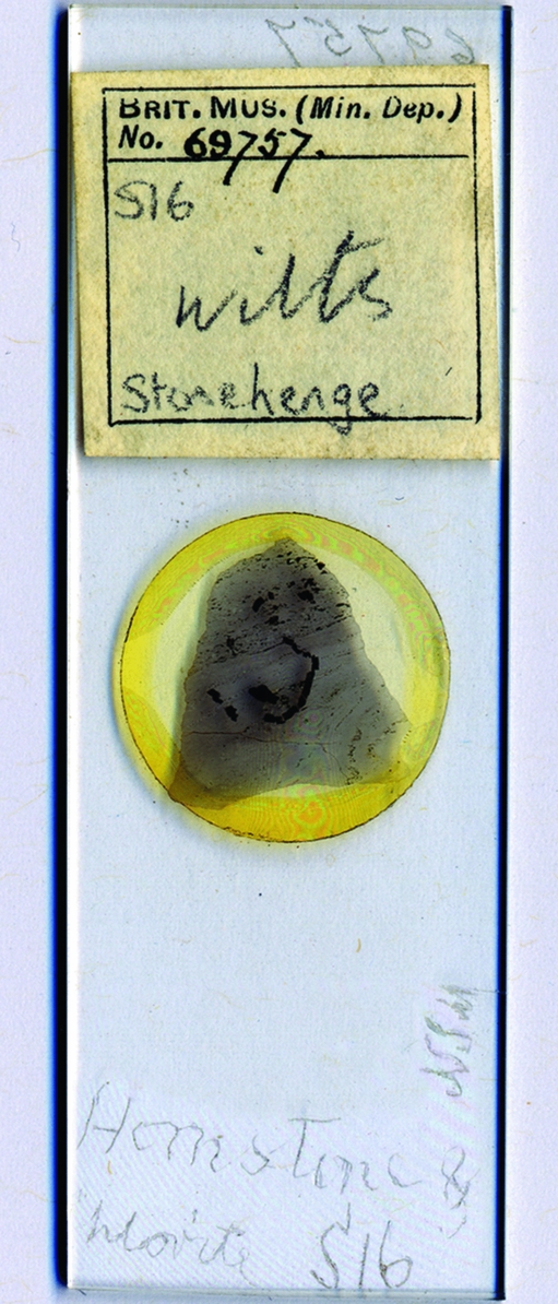
Specimen BM 69757 (Thomas Reference Thomas1923: fig. 1) was formerly held in the collections of the British Museum. Thomas records this as a fragment collected by William Gowland. We have re-examined this sample (now in the collections of the Natural History Museum) and its associated documentation (Bevins & Ixer Reference Bevins and Ixer2013). The records show that it was actually collected from a wagon track at Stonehenge on 7 April 1876 by William Cunnington (Figure 6). Gowland was working in Japan at this time and did not start excavation work at Stonehenge until 1901. The slide has the initials NSM etched onto it (which are those of Nevil Storey Maskelyne, former Keeper of Minerals at the British Museum between 1857 and 1880 and the first Keeper of Mineralogy at the Natural History Museum). This section was undoubtedly used by Maskelyne in his 1878 paper. This rhyolite has been sourced to Craig Rhos-y-felin (Bevins & Ixer Reference Bevins and Ixer2013). It has a fine foliation that we consider to be the ‘fluxion texture’ as referred to by earlier petrographers, including Maskelyne, John Wesley Judd and Thomas. Records show that this thin section was from a set of 15 samples from Stonehenge donated to the British Museum by William Cunnington in 1893.
Rhyolite thin section catalogued as BM.69757, described by Thomas (Reference Thomas1923).

Thomas's fig. 2 in his pl. XXIII (Reference Thomas1923) is a rhyolite from Carn Alw, showing a very fine banded texture. The sample was collected and originally illustrated by John Parkinson (see Parkinson Reference Parkinson1897: pl. XXXVI, fig. 1), and Thomas's figure is identical to that in Parkinson's paper, almost certainly confirming that Thomas used Parkinson's original image. Crucially, however, as has been shown (Bevins & Ixer Reference Bevins and Ixer2013), the photomicrograph only illustrates a limited area of the thin section (British Geological Survey (BGS) E Collection sample E13868), and when the full thin section area is examined, it is clear that there are coarser, crystalline layers of a kind not seen in any Stonehenge rhyolite. This led us (Bevins & Ixer Reference Bevins and Ixer2013) to argue further that the two samples illustrated by Thomas (figs 1 & 2 in pl. XXIII) cannot have the same provenance.
Thomas described the sample illustrated as fig. 3 (pl. XXIII) as a spherulitic rhyolite, labelled E1993 (in the Geological Survey's E Collection), and once more as being collected by Gowland. The present authors (2013) have argued that this was not collected by Gowland, but that E Collection records show it to be part of a subset of 13 rock fragments (curated as E1987–99) that were collected by Cunnington and passed to the Geological Survey in 1893. Re-examination of the entirety of this thin section demonstrates that the ‘spherulitic’ part of the sample grades into an argillitic rock (Bevins & Ixer Reference Bevins and Ixer2013), meaning once again that it is not as Thomas described. In contrast, this ‘spherulitic rhyolite’ might in fact be an accretionary lapilli horizon within an argillitic rock (Bevins & Ixer Reference Bevins and Ixer2013). Interestingly, we have identified a nearly identical sample (sample SH08-390) as a fragment from Darvill and Wainwright's 2008 excavation at Stonehenge (Darvill & Wainwright Reference Darvill and Wainwright2014).
Thomas's fig. 4 is a spherulitic (axiolitic) rhyolite from Carn Alw, collected and illustrated by Parkinson (see Parkinson Reference Parkinson1897: pl. XXXVI, fig. 3). This is a characteristic texture found in Carn Alw rhyolites, but it is not the same texture as illustrated by Thomas in his fig. 3 (Bevins & Ixer Reference Bevins and Ixer2013). This kind of axiolitic texture is not found in rhyolites at Stonehenge, either from the orthostats or the debris. Thomas cites the E Collection specimen, E1977, as having this texture, but this must be an error, because the Geological Survey daybook records show that E1977 is a specimen collected from the Isle of Man.
What we conclude from this re-examination is that the early descriptions of the rhyolites, including those by Maskelyne (Reference Maskelyne1878) and Thomas (Reference Thomas1923), were based on fragments collected in the Stonehenge area, and that these were originally derived from Craig Rhos-y-felin. They were not based on samples from in situ sampling of the orthostats because rhyolites from stones 38, 40, 46 and 48 are petographically very different from the Craig Rhos-y-felin rhyolite. Therefore, the descriptions of the four rhyolitic orthostats presented in Ixer and Bevins (Reference Ixer and Bevins2011b) represent the first detailed descriptions of those standing stones. It has been suggested (Bevins et al. Reference Bevins, Ixer, Webb and Watson2012), on petrographic grounds, that their sources—probably four different outcrops—may well lie in the area of the outcrop of the Fishguard Volcanic Group (which includes Craig Rhos-y-felin), north of the Mynydd Preseli. This hypothesis is supported by recent U-Pb age dates obtained from rhyolitic rocks from Stonehenge (including fragments thought to be derived from Craig Rhos-y-felin and from orthostat 48) and the Fishguard Volcanic Group, including the outcrop of Craig Rhos-y-felin (Bevins et al. Reference Bevins, Atkinson, Ixer and Evans2017). Consequently, it is clear that Carn Alw is not the source of any rhyolite found at Stonehenge, either orthostat or debris.
The source of the ‘calcareous ash’
Thomas illustrated this lithology in his pl. XXII, figs 3 and 4, stating that fig. 3 illustrates a fragment collected by William Gowland, labelled E1994 in the BGS Collection. In reality, it is from the set of fragments collected by William Cunnington, which were passed to the Geological Survey in 1893. This lithology (excluding sample E1994) equates to our Volcanic Group A (Ixer & Bevins Reference Ixer and Bevins2016). It is a soft, fine-grained argillitic rock composed of varying amounts of quartz, chlorite and white mica, with or without coarser aggregates of secondary calcite. The fine grain size means that the main mineral phases and their proportions can only be determined with certainty by X-ray diffraction. It occurs abundantly in the Stonehenge debris and is the lithology that best characterises the buried stone stump 32c discovered by H. Cunnington in 1881. It also probably occurs in the buried stone stumps 33e, 33f, 40c and 41d.
Thomas's fig. 4 (pl. XXII) appears to be of a similar lithology to that shown in his fig. 3, but, as noted above, with the exception of coarse calcite aggregates, the mineral constituents are difficult to resolve with routine petrographic techniques. His fig. 4 was a sample collected and thin-sectioned by Gerald Part (apparently in 1921; see Part Reference Part1922: 311). Thomas noted that it was collected ‘from an outcrop north of Foel Trigarn’ (Reference Thomas1923: ‘explanation of plates’). The thin section is not, however, present in the current Geological Survey E Collection, and so this cannot be verified. Part, however, made no specific reference to this lithology in his paper, nor to any specific outcrops north of Foel Drygarn; rather, he concentrated on the lavas of the Sealyham Volcanic Group (which lie to the south of the Preseli Hills and have no relevance to any Stonehenge bluestone) and also on the Foel Drygarn ‘keratophyre’, which again has no Stonehenge counterparts. Furthermore, we have not been able to substantiate the field source to which Thomas refers, despite extensive fieldwork in the area. This lithology (Volcanic Group A) is quite nondescript, lacking any critical defining characteristics and, as such, neither the thin section nor the lithology in general offer a realistic opportunity for definitive provenancing. The source of the ‘calcareous ash’ thus remains undetermined.
The source(s) of the dolerites
Thomas illustrated the Stonehenge and Preseli dolerites in his pl. XXII as figs 1 and 2 respectively. Fig. 1 is an ophitic dolerite, specimen number BM349.17 from the collections of the Natural History Museum. A search through these collections has, however, failed to locate this sample, and no sense can be made of the specimen number itself, suggesting that it is actually erroneous (M. Rumsey pers. comm.).
Thomas's fig. 2 is an ophitic dolerite from Carn Meini, sample E5715 from the Geological Survey E Collection; as with fig. 1, it is an ophitic dolerite. This sample was collected by Thomas on his (possibly only) excursion to the Preseli, in 1906, as described by Jones (Reference Jones1966). The BGS records clearly show that this was collected from Carn Meini.
Many of the dolerites used at Stonehenge contain the distinctive white spots that were a defining characteristic used by Thomas in his assertion that the Stonehenge dolerites came from Carn Meini. Other outcrops also show spotting however, including Carn Goedog, a locality that Thomas visited on his 1906 day excursion while collecting sample E5711, now in the BGS E Collection. It is fair to acknowledge that figs 1 and 2 do resemble each other, especially in showing an ophitic texture, but this is typical of many of the dolerites, including those exposed at Carn Meini and Carn Goedog. Interestingly, however, Thomas makes no reference to Carn Goedog in his paper, although sample E5711, collected by Thomas in 1906, is from that locality. It has proved to be difficult to distinguish between different Preseli dolerite outcrops using petrography alone, so we have used whole rock geochemistry to augment this.
In order to try to determine which dolerite outcrops may have been the source of the Stonehenge dolerites (spotted and non-spotted), Stonehenge orthostat and debris samples were geochemically analysed for a range of major and trace elements (Bevins et al. Reference Bevins, Ixer and Pearce2014), and the results compared with the extensive dataset for Preseli dolerites compiled by Bevins et al. (Reference Bevins, Lees and Roach1989). It was concluded that Carn Goedog (see Figure 2) was in fact the source of the majority of the Stonehenge samples, while the neighbouring dolerite outcrops Carn Breseb, Carn Gyfrwy, Cerrig Marchogion or Craig Talfynydd, crags adjacent to Carn Alw, and an un-named outcrop west of Carn Ddafad-las may have provided some of the stones. Interestingly, despite suggestions by Darvill and Wainwright (Reference Darvill and Wainwright2014, Reference Darvill, Wainwright, James, John, Murphy and Wainwright2016), no direct match to Carn Meini was identified. Thomas provides no direct evidence for Carn Meini being the source of the spotted dolerites from Stonehenge, and thin-section petrography is too imprecise in distinguishing between these dolerite outcrops.
Summary of our findings
As had been shown both petrographically and geochemically (Bevins et al. Reference Bevins, Ixer, Webb and Watson2012; Bevins & Ixer Reference Bevins and Ixer2013), Carn Alw is not the source of the Stonehenge bluestone rhyolites, as originally proposed by Thomas (Reference Thomas1923). It seems that Thomas only examined debris material, as he described the rhyolites as having a ‘fluxion texture’. This is the characteristic foliation present in rhyolitic debris at Stonehenge that we have sourced to Craig Rhos-y-felin, and which might have been present in the Stonehenge Landscape as a result of the destruction of orthostat 32d (or less probably 32e). Amongst all of the debris material that we have studied from the Stonehenge Landscape, only a very small fraction (far less than 1 per cent) appears to have been derived from rhyolitic orthostats 38, 40, 46 and 48. None of these four comes from Craig Rhos-y-felin, although they most probably originated in the north Pembrokeshire area, a contention supported by the recent date obtained from a fragment of stone 48, which has a Middle Ordovician (Darriwilian) age, which is the age of the Fishguard Volcanic Group (Bevins et al. Reference Bevins, Atkinson, Ixer and Evans2017).
Thomas considered that the ‘calcareous ash’ was derived from an outcrop to the north of Foel Drygarn, based on the findings of Gerald Part. Part (Reference Part1922), however, makes no specific reference to this lithology, and we have failed to identify it in the area around Foel Drygarn. The lithology as seen in the debitage lacks any defining features, and, as broadly similar lithologies are widespread in the north Pembrokeshire area, provenancing it will be difficult.
Finally, Thomas identified the spotted dolerites as coming from Carn Meini, whereas geochemical analysis shows that Carn Goedog is the actual source of much of the spotted dolerite present at Stonehenge. Despite possible archaeological evidence for quarrying (Darvill & Wainwright Reference Darvill and Wainwright2014), no exact geochemical match with Carn Meini dolerite has been determined.
Explaining the discrepancies
There are notable discrepancies between our provenancing studies and those of Thomas, as presented in his seminal paper in The Antiquaries Journal in 1923. Thomas was without doubt an excellent petrographer, and had considerable experience at looking at Lower Palaeozoic volcanic and sedimentary rocks, both in the field and in the laboratory. As noted earlier, he had spent the years between 1901 and 1910 working as a field geologist on sheets covering the ground to the south of Mynydd Preseli (the latter being the proposed source of the bluestone lithologies). We can, however, only find record of a single excursion by Thomas into the Mynydd Preseli, in 1906. Jones (Reference Jones1966) described this excursion, and a set of 15 samples (E5705–E5719) are recorded in the Geological Survey's day book for 1906, collected by Thomas from outcrops between Rosebush and Crymych, exactly the route described by Jones. Thomas's last mapping period in south-west Wales was in 1910, before he transferred, firstly to north Wales and then to London.
It was not until some 10 years after leaving south Wales that Thomas was approached by the Society of Antiquaries to investigate the provenance of the Stonehenge bluestones; he made his first visit to Stonehenge in 1920. Thomas clearly had access to the set of 15 samples that he himself had collected in 1906. What is crucial to this study is the question of what other specimens he was able to draw on for his comparative study. In the ‘summary and conclusions’ section (Reference Thomas1923: 259), he acknowledges Hawley for “the granting of facilities for visiting Stonehenge and inspecting not only the stones themselves but the abundance of fragments found during recent excavations”. He also thanks “Mr Cunnington of Devizes” for providing access to thin sections of fragments “collected by the late William Cunnington and described by Mr Davies and Sir Jethro Teall”, and further thanks the Keeper of Mineralogy at the Natural History Museum for allowing the study of specimens and sections studied by Maskelyne and Judd. Finally, he thanks Mr J. Parkinson for the loan of “his described specimens of rocks from Prescelly” (1923: 259–60), and also acknowledges Gerald Part, who provided the sample and thin section of ‘calcareous ash’ that Thomas described and illustrated as his pl. XXII, fig. 4. As mentioned above, the specimen and thin section from Part cannot be located at the time of writing, but the collection of thin sections from Parkinson are currently in the Geological Survey E Collection. There are 32 thin sections donated by Parkinson (numbers E13858–89), of which 26 are from Carn Alw, 5 are from outcrops around and on Foel Drygarn, and a single one is from an outcrop near Rosebush.
In looking at these collections of specimens in more detail, we can see that Thomas examined almost entirely (if not exclusively) debris material from Stonehenge. The Cunnington samples were clearly all debris material. The survey daybook records E1987–99 as being specimens collected and presented to the Museum of Practical Geology, Jermyn Street, by W. Cunnington, FGS, and adjacent entries suggest that they were donated in 1893 (falling between the entries for 20 March and 5 June 1893). This appears to be a subset of Cunnington's samples, a more complete set of which were examined and described by Maskelyne (Reference Maskelyne1878), Cunnington (Reference Cunnington1884) and Teall (Reference Teall1894), and which Harrison et al. (Reference Harrison, Sanderson and Hart1979) recorded as being collected from excavations at Stonehenge between 1876 and 1881. Curiously, Thomas records some of the Cunnington samples (specifically E1994 and E1993; his pl. XXII, fig. 3 and pl. XXIII, fig. 3, respectively) as being fragments collected by W. Gowland. This is clearly in error, as is his reference to an axiolitic-type rhyolite as being sample E1977 (1923: 251), the latter being a Geological Survey sample collected from the Isle of Man. We think that this should read E1993. Gowland excavated at Stonehenge in 1901, and debris material from Gowland's excavations was acquired by the Natural History Museum in 1914 (sample numbers BM1914.1–1914.37), so it is probable that Thomas also had access to this as well. Interestingly, however, Thomas makes no reference to these samples.
At the time of undertaking his Stonehenge provenancing work (in the period 1920–1923), Thomas was not actively undertaking fieldwork in the Mynydd Preseli area, and had to rely predominantly on the set of samples he collected in 1906 (totalling 15 samples from the whole area between Rosebush and Crymych), on 13 samples in the survey collection from Cunnington, and on the works and specimens of Parkinson and Part. In essence, Thomas had an incomplete and unrepresentative set of samples from the Mynydd Preseli, and a limited opportunity to study these rocks systematically in the field.
Conclusions and implications
Our main conclusion is that the provenances for the bluestones as presented by Thomas are not based on reliable evidence, but appear to have been influenced predominantly by a set of samples collected during a single field excursion to the Mynydd Preseli in 1906, 14 years before his investigation of Stonehenge. He also had to rely on samples and thin sections from other sources, which led to a bias in the sample available for comparison; this was especially the case for Parkinson's thin sections, which were predominantly from the outcrop of Carn Alw, reflecting Parkinson's interest in spherulitic rhyolites. Hence, Thomas's claims about the proposed sources of the Stonehenge bluestones are unreliable.
This helps to explain why our recent studies have identified alternative sources. It could be argued, of course, that these recent studies have the added advantage of access to modern analytical techniques, such as X-ray fluorescence spectrometry for whole rock geochemistry, or ICP-MS laser ablation techniques for mineral composition determinations. Basic transmitted and reflected light microscopy gave us our first indication that the rhyolite came from Craig Rhos-y-felin, rather than Carn Alw as was previously thought. The rest of our provenancing of the bluestone lithology followed on from this fundamental discovery. Our work also highlights how easy it is to accept published findings as ‘gospel’ without challenge. This has been the case with Thomas's paper for over 80 years. Our findings are an essential first step to identifying where the Stonehenge bluestones may have actually been extracted from, enabling archaeologists, geologists and geomorphologists to test and debate these suggestions better, at Craig Rhos-y-felin (John et al. Reference John, Ellis-Gruffydd and Downes2015; Parker Pearson et al. Reference Pearson, Bevins, Ixer, Pollard, Richards, Welham, Chan, Edinborough, Hamilton, Mcphail, Schlee, Schwenninger, Simmons and Smith2015) and Carn Goedog (Parker Pearson Reference Parker Pearson2016b; Parker Pearson et al. in press).
Acknowledgements
We wish to thank the British Geological Survey (Mike Howe and Chris Wheatley) and the Natural History Museum (David Smith and Mike Rumsey) for access to their collections and archives. Our thanks also go to Amanda Valentine-Baars for providing invaluable laboratory technical support, and to Jim Turner for assisting with the figures. Finally, we acknowledge numerous collaborators on Stonehenge matters, especially Mike Parker Pearson, Tim Darvill, the late Geoff Wainwright, Nick Pearce, Peter Webb, Jane Evans and the late John Watson. Comments by two reviewers helped considerably to improve this contribution.