
India's Northeastfrontierremains invisible in many “India studies.”Footnote 1 In fact, this “culture area” is at the margin of three firmly located geographical regions as well as academic “study areas”—South Asia, Southeast, Asia and East Asia (Maaker and Joshi Reference Maaker and Joshi2007, 382). Modern national maps know no better way of accommodating such an overlapping zone other than rendering it “remote” in ways that erase the region from the public consciousness (Ludden Reference Ludden2005).
The sub-Himalayan area is not simply a barrier dividing “riverine communities” in India and China. In the eyes of mountain dwellers, mountain crests appear rather like bridges, not necessarily barriers (as perceived by lowlanders). Historically, these highlands acted as a “contact zone” (Pratt Reference Pratt1991) and an “ethnoscape” (Appadurai Reference Appadurai1990) between peripheral civilizations of Inner Asia. Amid shifting boundaries and political maps, India's Northeastern borderland has a regional personality of its own,Footnote 2 like the Yunnan borderland of southwestern China, the Ganga-Yamuna doab in North India, or the Deccan peninsula in South India. British geographer William Kirk argued that this Himalayan area is “a geographical region in its own right” (1962, 156). “It has received peoples and cultures,” Kirk further remarked, “from many directions, at various times, but has imposed on them its own peculiar regime born of the unity of high places … This is one of the earth's greatest highland zones, nourishing its own complexities of race and culture, and exhibiting its own internal environmental contrasts” (1962, 156).
India's Northeast frontier forms part of a larger “Inner Asia” or “Asian space” defined by mountains, slopes, and valleys (cf. Kirk Reference Kirk1962; Ludden Reference Ludden2005). The “red river” (the Brahmaputra) and the surrounding “blue hills” largely epitomize the pattern of the Northeast's regional landscape (cf. Barua Reference Barua1991). The red river originates from a Himalayan glacier as the Tsangpo in Tibet before its majestic appearance in Arunachal Pradesh and Assam within India's Northeast. Likewise, the blue hills of the Northeast are geological offshoots of the eastern Himalayan range. “The Brahmaputra has filled its tongue-like longitudinal valley with a massive alluvial deposits of great agricultural potential,” Aijazuddin Ahmad noted (Reference Ahmad1999, 81). Peasant culture flourished in the “perennial nuclear region” (Ahmad Reference Ahmad1999, 82) of the Brahmaputra Valley. It provided the template for medieval states under Kamrup (Koch Hajo) and the Ahom swargadeos (kings). Yasmin Saikia rightly insisted, “The lack of ‘fixed’ position for Assam within the Indian political imagination is countered locally by a seemingly permanent agrarian culture created by the unquestionable presence of the Brahmaputra River which dominates life and the economy along its banks” (Reference Saikia2004, 9). The less fertile uplands around the nuclear region supported a “hill society” underpinned by subsistence swidden cultivation. The same pattern was also replicated on a smaller scale in Manipur, Tripura, and the Barak Valley in medieval Northeast India.
Objectifying the Geo-Body of a Colonial Borderland
This paper intends to engage established concerns of the “new history of cartography,” with specific reference to the Northeast borderland in Indian historical geography. This entails a defense of the region as a scale of historical analysis. Regional history is larger than the local, but smaller than national or global history. Historical enquiry at the regional level can uncover the dynamic play of sectional forces—not necessarily secessionism—too little recognized by nationalist historiography. The writing of Northeast India's regional history appears to fall between the poles of regionalist insularity and nationalist superficiality. Special historical studies in this area remain remarkably insular in a positivist vein, and their dense factuality hardly relates to wider historical problems. But certain problems belong to the common domain, and the uniqueness of a region can be better thrown into relief by a comparative angle of vision. An engagement with “geographical history”—especially an enquiry into divergent cartographic cultures—provides a corrective to the prevalent view of a static Northeast existing in “splendid isolation” (cf. Nag Reference Nag2002, 17; Schendel Reference Schendel1992, 95).
Of late, David Ludden (Reference Ludden2005) noted the usefulness of “geographical history (or historical geography) to locate current social problems” in India's Northeast, fettered as it is by the tyranny of national geography and the closures of territorial boundaries. In a slightly different context, Ludden also argued for setting the academic agenda “at intellectual intersections of mobility and territorialism” (Reference Ludden2003, 1070). In spite of its vital interest, the present topic has been grossly understudied in the historical and geographical literature. Perhaps this is attributable to the general neglect—apart from rare exceptions such as Susan Gole (Reference Gole1989) and Matthew H. Edney (Reference Edney1999)—of historical geography or geographical history in South Asia.
At the conceptual level, this paper may be seen as a small contribution to the integration of insights that emerge from the “new history of cartography” (Harley and Woodward Reference Harley and Woodward1987), and some perceptive but fragmented studies in colonial history and boundary making at the “turbulent frontier” (Galbraith Reference Galbraith1960, 150). Today, a new cartographic history is interested in the different ways of seeing and representing space in the mosaic of human culture. Maps are not mirrors that passively reflect the world; they have always been “a way of seeing” or “a mental image” to make sense of the world. Like British imperial maps, maps of Indian cosmography were socially constructed. After all, even a satellite-based map is not free from the effects of power and discourse (Harley Reference Harley1989; Harley and Woodward Reference Harley and Woodward1987). This is not a history of cartography, but focuses on the interface between European cartography, local cosmography, and borderlands history, which, were, in turn, shaped by imperial power and spatial knowledge. In this sense, the paper fills in a gap in the geographical history of India's Inner Asian borderland that holds a useful key to understanding South Asia today.
Central to the theme of the paper is the implementation of colonial power in marshalling all available resources in surveying, mapping, and demarcating India's Northeast borderland as the ever-shifting “turbulent frontier” that attracted imperial concern for order and stability. This is an account of the making of “map-like models” (Blaut et al. Reference Blaut, Stea, Spencer and Blades2003) and the history of “mapping” in the broader sense as a cultural universal—the mapping of colonial Northeast India over a relatively long period. This approach will offer a high-altitude view of the region's shifting “historic positions” (Prakash Reference Prakash1990, 384) as the imperial fringe of the Mughals, the British Raj, and its Indian successor state. Flaunting conventional periodization can throw into relief the persistent state project of making legible frontier spaces in the Northeast that spans precolonial, colonial, and postcolonial regimes (Scott Reference Scott1999). Mapmaking and imperialism shared one thing in common—a passion for territory. Edney pithily put it, “To govern territories, one must know them” (1999, 1).
More than four decades back, Edmund Leach (Reference Leach1960) already noted the novelty and arbitrariness of the European myth that every political state or state-like entities should, ipso facto, have definite boundaries that in some way correspond to differences of culture and language. He revealed the anomaly of applying, in tribal belts and ethnic realms, the political dogma that territorial sovereignty is absolute and indivisible. Building on this perceptive idea, Thongchai Winichakul (Reference Winichakul1994) considered the positive role of modern maps and boundaries as a creator of nationhood, the “geo-body” of a nation, or even regional identities. He further said, “The lack of interest in the history of a nation's geo-body had led to many misleading interpretations which assumes modern concepts of space in explaining the incidents in which the pre-modern discourse still prevailed.” Sanghamitra Misra's recent study of Goalpara district in colonial Assam noted that the early British Raj “had to first contend with the conditions of overlapping territoriality and sovereignty, which characterized the indigenous polity of this region” (Reference Misra2005, 222). Misra further viewed colonial boundary making and the fixing of previously fluid realms as “a confrontation between indigenous and colonial notions of political space” (Reference Misra2005, 222). Extending this line of enquiry, the present piece examines the creative tension between indigenous ways of picturing the world and European cartographic culture.
It is helpful, therefore, to examine how geographical discourses—cartographic culture in particular—impinge on the construction of a distinctive “geo-ethnic” regional identity delineated by inner and outer boundary lines. Ultimately, surveyors and mapmakers objectified and enacted the “geo-body” of British Assam pictured by European maps, which reduced India's Northeast borderlands to thin boundary lines. Drawing on Bernard S. Cohn's (Reference Cohn and Cohen1987) usage, we understand “objectification” here not as a timeless mode of describing colonized objects (people or places), but as a specifically modern process of enumerating, calibrating, or reinventing previously fuzzy ideas of space and culture into consciously rational ends. In this sense, we discuss how survey maps of the Raj “objectified” India's Northeast; the same may be true of the process of objectification in postcolonial India. By implication, modern techniques of objectification (whose intellectual roots go back to the Enlightenment) cannot be attributed anachronistically to premodern conquest regimes such as the Ahoms or the Mughals.
Mapping Mughal Knowledge of the Northeast
Connoisseurs of art collection in India treasured maps as works of art long after they had lost their stern practicality. Interestingly, most of our knowledge of Indian maps comes from art historians (Schwartzberg Reference Schwartzberg, Harley and Woodward1992). An avid map collector herself, Susan Gole hoped that, in future, many Indian maps may still tumble out of family cupboards. It was her luck to stumble on an old Indian copy of an Arab “world map.” This rare find was made among waste papers in a Delhi bazaar (Gole Reference Gole1989, 28). She also observed that Chinese maps of the western region (beyond India's Northeast) were based on Indian sources. The knowledge transfer was mediated by Chinese pilgrims around the seventeenth century ad. Ironically, the tradition of making secular world maps in India has “since perished, along with all knowledge of them” (Gole Reference Gole1989, 27). Gole attempted to explain the reason: “As art form they [Indian maps] are not universally admired, and as geographical artifacts they soon gave way to modern surveys” (1989, 12).
Early European maps of India sometimes made oblique references to indigenous sources acknowledged as “legend notes” (Schwartzberg Reference Schwartzberg, Harley and Woodward1992, 326). Those cartographers disparaged local knowledge that did not fit into their definition of a map. Premodern maps in India usually served sacred purposes. No wonder the secular state in British India apparently saw little merit in preserving them. Colonial contempt for Indian maps was well expressed by a British surveyor in Bengal, Francis Wilford: “They have also maps of India, and of particular districts, in which latitudes and longitudes are entirely out of question, and they never make use of a scale of equal parts” (Reference Wilford1805, 270).
The chief interest of indigenous maps lies in their capability to reveal a glimpse of another world through the eyes of those mapmakers. The lack of scale and orientation in Indian maps baffled many European visitors (see Singh and Khan Reference Singh and Khan1999). In a sense, Indian mapmakers had their own idea of scale. Unlike contemporary European cartographers, they used the scale of importance—not of distance and mensuration. Towns and villages of special interest would occupy more map space (Gole Reference Gole1989, 14). In Indian cosmological maps, natural features attained fabulous shapes and sizes, and distances were often expressed in terms of the time it took a traveler to cover them.
The earliest surviving Indian globe is a Puranic bhugola (earth ball) dated to 1571 ad (Digby Reference Digby1973). When the Jesuits visited the Mughal court at Agra in 1580 ad, they presented an atlas to the emperor Akbar. Sir Thomas Roe, too, offered the latest version of Mercator's world map to the emperor Jahangir in 1615. The gift was reportedly neither understood nor accepted by the Mughal court. However, the globe became an important motif for court painters from the time of Jahangir. Paintings in this category depicted the emperors standing over a globe, grabbing it with hands, or using it as a footstool (Gole Reference Gole1989, 26). They signified the imperial influence of their patrons over extensive earthly domains.
The most important of such works is preserved in the Freer Gallery of Art in Washington, D.C. Titled Jahangir Embracing Shah Abbas, it depicts Jahangir embracing his powerful Persian rival. The Indian emperor was entangled in a territorial dispute with his Iranian counterpart over the possession of Kandahar beyond the Mughal northwest frontier (Schwartzberg Reference Schwartzberg, Harley and Woodward1992, 408–9). This painting shows a number of place-names, including Koch and Purb on its Northeast frontier. Koch was a reference to the Koch (modern Mech or Bodo tribe) of Northeast India. Purb had no identifiable place, but it signified east (Schwartzberg Reference Schwartzberg, Harley and Woodward1992, 410). During the reign of Jahangir, Koch Bihar and Kamrup in India's Northeast frontier were hotbeds of revolt. For instance, the Sanatan Sardar uprising against the Mughal mansabdari revenue regime took place on the south bank of the Brahmaputra during the time of Jahangir (Bhadra Reference Bhadra and Guha1999, 44).Footnote 3
The kingdom of Koch Bihar was an ascending star on the political horizon of medieval Assam—around mid-sixteenth-century ad (Bhattacharyya Reference Bhattacharyya1994, 2, 41). Soon the kingdom split in half when Kamrup (Koch Hajo) seceded in 1581 from its parent state (Gait Reference Gait1926, 57). Enfeebled by the partition, the Koch regimes were easy prey for Mughal imperial designs. Gauhati succumbed to Mughal control in 1639 (Wade Reference Wade and Sarma1800). The downfall of Koch Bihar in the west and Koch Hajo (Kamrup) in the east paved the way for Mughal expansion further east into the heartland of the Tai-Ahom kingdom at the upper course of the Brahmaputra Valley.
Under Mir Jumla (the ambitious nawab of BengalFootnote 4), the Northeast frontier encountered the full force of Mughal military might from 1662 to 1663 ad. The Iranian-born noble had begun his career as a clerk in the goldmines of Golconda in South India.Footnote 5 When the mir arrived at Dacca (Bengal) on May 9, 1660, he was a man with a mission. His original assignment was to conquer Assam and Arracan (Magh) across the Indo-Myanmar hills. Later, the Arracan plan was abandoned, and Mir Jumla concentrated his efforts on the Koch and Ahom kingdoms at the Northeast frontier. The mir had strategic as well as commercial motives, although his official chronicler, Shihabuddin Talish in Fathiya-i-Ibriya, dubbed the Assam campaign of 1662–63 “a holy war” (Dutta Reference Dutta1984, 58). The strategic intention was to turn Assam into “the base of an attack on Burma and China” (Bhattacharyya Reference Bhattacharyya1994, 322). In a triumphal moment, Mir Jumla even confided to the Mughal emperor “that the next campaign would carry him to the confines of China” (Sword Reference Sword1992, 25). Though the Mughals commanded fairly competent knowledge of Lower Assam, they appeared to have only shadowy ideas about upland Assam.
Mir Jumla's war in Assam was easy to win, but difficult to retain. In this prolonged conflict, the scale of the nawab's operation was unprecedented. Besides 12,000 cavalry and 30,000 infantry, he employed about 400 large warships called ghrabs, led by Portuguese, Dutch, and English sailors (Gait Reference Gait1926, 132; Shakespear Reference Shakespear1914, 40). Mir Jumla kick-started his campaign in December 1661 by invading Koch Bihar, which lay prostrate before the advancing imperial army. From this new base, Mir Jumla launched his famous Assam campaign in January 1662. The Mughal army crossed the turbulent Manas River to execute the Mir's plan to invade by land and river routes (Dutta Reference Dutta1984). By early February 1662, the Mughals had reached Gauhati, Kamrup's capital, without serious resistance from the Ahom forces (Dutta Reference Dutta1984).
But in Upper Assam, the Mughal army saw fierce action along a series of Ahom forts. However, the most powerful attack came from the “Ahom armada of 700 or 800 ships” (Dutta Reference Dutta1984, 66) at the naval battle of Koliabar. Despite stiff Ahom defense, the nawab made a triumphal entry into the “fabulous” Ahom capital of Garhgaon on March 17, 1662. The Ahom king fled to the hill country of Namrup at the easternmost edge of his kingdom (Gait Reference Gait1926). That was the climax of Mir Jumla's military feat in Assam.
The mir, however, reached his nadir with the onset of the southwest monsoon. Soon, torrential rains forced the nawab to vacate Garhgaon for a campsite less exposed to the elements. He foolhardily desired to pursue the Ahom king right into his hill hideout. Cut off from his navy and his main army, the nawab was condemned to endure the entire monsoon rains there. The Ahoms knew their country and local topography better than their invaders (Dutta Reference Dutta1984). In fact, the Ahom army appeared to be at its best under monsoon conditions. Using guerilla tactics and night attacks, they constantly harassed the Mughal army while cutting its supply lines. The half-starved Mughal camp was visited by pestilence and malaria. Even worse, the nawab himself fell ill. When the rains finally ceased, the Mughal general patched up a peace treaty at Ghilajorighat with the Ahom rajah on January 22, 1663. Because of serious illness, the nawab could not sign the treaty personally. On his way back to Dacca, the ailing general died of fever (Shakespear Reference Shakespear1914). Soon after Mir Jumla departed, the Ahom forces recovered their territories and renewed their effort to control Kamrup in Lower Assam. James C. Scott pertinently remarked, “The premodern state was, in many crucial respects, partially blind … It lacked anything like a detailed ‘map’ of its terrain and people” (Reference Scott1998, 2).
Ways of Seeing: Reorienting Local Cosmography
Prominent as it was, cosmography coexisted with other more mundane concepts of indigenous space. Route maps to a holy site or local maps were no celestial plans. A local map represented real places on the Earth's surface—albeit without reference to the globe. Cosmography was entrusted with the duty of explaining the whole universe. In this context, Thongchai Winichakul observed that particular concepts operated within certain terrains of knowledge, and other kinds of knowledge took over beyond that limit (1994, 33). He further remarked that “the classification of local geography and the whole globe as separate categories in the indigenous knowledge about space is comparable to the separate classification in modern science today of geography and astronomy or astrophysics” (1994, 31).
The hill societies of the Northeast had a rich oral tradition of cosmography and creation myths. Two Sanskrit sources, Yogini Tantra and Kalika Purana in ancient Assam, provide useful hints to the changing conceptualization of sacred space and cosmography. These texts reflect the transformation of a local tantric goddess of the Garo hill tribes into a puranic goddess called Kamakhya, who eventually merged with the mother goddess Durga under a Koch Bihar king who rebuilt the Kamakhya shrine in 1565 ad on a sacred hillock named Nilachala, meaning “blue mountains.” It has been suggested that “Kama-rupa”—an old name for Assam—was derived from the goddess Kama-khya (Kakati Reference Kakati1948).
The princely states of Manipur, Tripura, and the Tai-Ahoms of Assam meticulously maintained royal chronicles. About two hundred buranjis (meaning “storehouse of knowledge”) have been discovered in Tai-Ahom language and Assamese. The Ahom Buranji (translated into English by Golap Chandra Barua in 1930) opens with a creation myth that presents a cosmological view of the Tai-Ahom world. God was depicted as shapeless lump of flesh suspended in the sky like a swarm of bees. The Ahom creator had a pair of golden spiders erect eight pillars in eight corners of the Earth. The spiders connected the Ahom mountains by a rope to a pillar on Mount Meru of Hindu mythology. As the spiders labored on the connective web, the Ahom Buranji reads, “They went quickly backward and forward, like a women in her looms” (Barua Reference Barua1930, 2). Indeed, the fabric of the Ahom universe was interwoven by spider webs of Tai-Ahom and Hindu myths. The verticality of such a local cosmograph stands in sharp contrast to a horizontal map of bounded territories delimited by modern state interests (cf. Anderson Reference Anderson1991, 171).
European cartographers had begun to indicate certain identifiable features of Assam since the sixteenth century ad. Maps of the Portuguese J. B. Lavanha (circa 1550) and the Italian G. B. Ramusio (1554) marked the medieval towns of Comotah (Kamata) and Caor (Koch or Kamrup) in Lower Assam (C. E. A. W. O. 1927, 271). The upper part of Assam north of Goalpara was unrecognized until the first British survey and military expedition under Captain Welsh from 1792 to 1794. There is scanty information about indigenous mapmaking before Mughal and European contacts. A seventeenth century puthi (old manuscript) presented “an account of the Political Geography of Assam Valley” (Gait Reference Gait1897, 17), but there is no evidence of map use.
In the Northeast, there is at least one extant example of a local map of 1831 called “A Sketch of Cachar (in Assam), compiled from a Native Map.” In the six-volume History of Cartography …, Schwartzberg noted, “From the northeastern corner of the Indian subcontinent comes another large-scale map of a rather small area” (1992, 427). He considered it to be a hybrid production in which both Indian and European elements coexisted. The map was found in a 1849 correspondence of the revenue surveyor in charge of Goalpara district in Lower Assam. It noted the four cardinal directions and indicated many estates and locations in the Habraghat Pargana. But the map had no definite orientation for reading names. The mapmaker was probably a clerk of the deputy collector and “in no way a surveyor” (Phillimore Reference Phillimore1952, 111–14).
The Ao Naga cosmology, for instance, recounted how a creator deity called Lizaba flattened the plains of the Brahmaputra Valley. By tradition, that was all Lizaba—the world designer—did, or had to do (Clark Reference Clark1911, 350). Later missionaries introduced “map literacy” in the hills. This turned the local people into consumers of Western world maps. To give an example, mission schools in a hill area of the Northeast placed an order for 375 maps from the government in 1905. But the missionaries were not just passive map users; they were also brokers and producers of maps for the consumption of home donors. A missionary enterprise in the Northeast described maps as “the means of creating an interest in our Mission in many friends at home.”Footnote 6 However, the objectifying mission maps downgraded the tribal world and contained its pride. An American Baptist missionary among the Ao Nagas wrote, “When our new missionary map from Boston was hung up before them … [it] led old Deacon Scubungallumba to drop his head and mutter almost under his breath, ‘Ish, Ish! How great we have thought ourselves, as though we were the big part of all creation!” (Clark Reference Clark1907, 108).
With new map literacy, old cosmologies imploded under the impact of a secular cartographic culture. Things fell apart, but soon got recast into a hybrid cosmography. In the Lushai (Mizo) hills, a local informant honed the newly acquired map skills to describe the Lushai life world to a colonial official. He “embellished his essay with a map” (Shakespeare Reference Shakespeare1912, 62). This cosmological plan was a syncretistic sketch that depicted the soul's journey beyond the grave in Lushai cosmography. In the pre-Christian Lushai worldview, the passage to the afterlife was the monopoly of a pagan fury called Pu Pawla. After missionary contact, Isua (Jesus), too, found a place on the plan (route map) to provide security for the newly opened highway to the Christian village. (Imperial surveyors, in fact, mapped and opened new military routes in the Lushai hills.) Amid changes, the old route to the dead people's village (mithikhua) still remained intact. The dreaded Pu Pawla was replaced by an equally notorious figure, Seitana (Satan). Such a hybrid map constituted part of the process of objectifying the “geo-body” of British Assam (including the Lushai hills). This did not, of course, produce structural transformations in the local societies, but it left an indelible imprint on the imaginaire—the way the locals conceived their life world and the possibilities of reformulating it (cf. Kaviraj Reference Kaviraj1997, 13).
Different concepts of space—whether they be celestial or terrestrial—served diverse social and sacred purposes. Within their own limits, they coexisted within separate terrains of operations. However, colonial cartographers bemoaned the lack of scale or orientation in Indian map experience. The alleged “lack” of scale or sharp boundaries in indigenous hybrid maps and cosmological maps was not simply the outcome of some politico-technical defect. European maps represented a different way of seeing the world. They mapped a new territoriality or “geo-body” of India's Northeastern borderland. In fact, Winichakul Thongchai asserted, “Modern geography was not simply new data added to existing conceptions. It was another kind of knowledge of space” (1994, 36).
In the hill societies of British Assam, this new concept and practice of cartography both reflected and effected corresponding changes in the local power structures, whose base shifted “from kin-ordered to territorial authority” (Schendel Reference Schendel1992, 109). Tribal chiefs ruled over people bound by patrimonial loyalties, not over land that was a free gift of nature. The old regime was legitimated by either a real or an imagined lineage and kinship system. The creation of “accredited” territorial chiefdom in colonial Northeast perfectly suited colonial interest in the efficient collection of hill tax or house tax. Colonial cartography provided a powerful technology of rule to achieve exactly such a secular end.
British Survey: Producing Colonial Assam-on-the-Map
Unlike the Mughal Empire, the administrative core of the British Empire was built around knowledge-producing institutions such as the army, museums, universities, and the Indian Survey (Bayly Reference Bayly1999, 143; Kumar Reference Kumar2006; Richards Reference Richards1993). Nicholas Dirks hammered this point home when he asserted—with a little exaggeration—that colonial “knowledge both enabled conquest and was produced by it” (Reference Dirks and Cohen1996, ix). Cartographic knowledge readily lent itself to the services of the British imperial project. The British Raj was the most data-intensive “paper empire” (Richards Reference Richards1993, 81). The spread of map literacy and new print technology in Europe enabled the British to project their imperial desires on paper—to be precise, on paper maps. No wonder British India depended on maps far more than its imperial predecessors. The “stern practicality” (Livingstone Reference Livingstone1994, 216) of mapmaking and surveying merely camouflaged imperial desires and power. During the “age of empire” in Europe, “geographical conquests [did] not have … a purely scientific and platonic interest” (Livingstone Reference Livingstone1994, 218)—rather, they mapped the path to imperial exploitation.
Surveying was not unique to nineteenth-century imperialism; in fact, the term “survey” had undergone changes in its meaning over time. In the context of seventeenth-century England, according to Richard Helgerson, the terms “survey,” “description,” and “chorography” were employed almost synonymously, as they were all recognized as members of the same genre—tied up by a similar concern for “place” and especially its “particularity” (Reference Helgerson1986, 71). Later, chorography disengaged itself as an autonomous genre of description, and “survey” was more sternly pressed into the service of imperial bureaucracy. Cohn (1996) further tells us that, for the British in India during the late eighteenth century, “survey” also meant a form of exploitation of the natural and social landscape through systematic and official investigation. The result was a vast official documentation project that included the Survey of India, under the direction of George Lambton, which eventually covered India with an imaginary grid on which the government could locate any site in India.
In 1823, the Court of Directors determined on the publication of a complete “Indian Atlas.” The beginning of the Anglo-Burmese War in 1824 led to the acquisition of much valuable geographical knowledge on the Upper Himalayas. Until that time, the only knowledge available had been derived through the Jesuit missionaries, Chinese sources, and the travels of Lamas (Tibetan monks). Many of the early deputations and files on Burma available in the secretariat were dominated by an eighteenth-century Orientalist's interest in “Burma books” and details of external trade (Bayly Reference Bayly1999, 118). Successive embassies from that of Captain M. Symes of 1795 onward had been humiliated by the court of Ava (Bayly Reference Bayly1999). The Jesuits were reported to have operated in Eastern India since 1576 (Becker Reference Becker, Leicht and Karotemprel1923, 91),Footnote 7 and an Italian missionary called Capuchins had managed to enter Tibet in the mid-seventeenth century before the area was closed to missionaries in 1742 by the Buddhist Lamas (Becker Reference Becker, Leicht and Karotemprel1923, 94). The first missionaries to visit the Brahmaputra Valley were Stephen Cacells and J. Gabral; both were interested in exploring a new route into Tibet and China (Dena Reference Dena1988, 18; Wessels and Nijhoff Reference Wessels and Nijhoff1988),Footnote 8 and they left some sketches of the region.
Early in the spring of 1824, an aggressive Burma appeared at the Northeast frontier of British Bengal. It was then that the “Northeast” swung into the ken of the Company Raj at Calcutta, which was, for all practical purposes, caught unaware. This condition has been aptly described as “information panic” (Bayly Reference Bayly1999, 149). British knowledge about Burma continued to remain patchy during the three Burmese Wars (Kumar Reference Kumar2006). In spite of winning the war, the British committed a number of avoidable mistakes during the Anglo-Burmese War of 1824–26.
That was the context within which imperial surveys emerged in Northeast India, starting with the official mission of Lieutenant Richard Wilcox to “discover” the source of the Brahmaputra River in the Himalayas. In fact, the Indian Survey was one of the key institutions of knowledge production in British India, and the topographical survey formed just a part of the larger structure of colonial knowledge. Because the free flow of information and competence in intelligence gathering was directly linked to the stability and integrity of the British Empire, the information famine at the start of the Burmese War was a risk that no alien ruler would like to see repeated. In his report of 1835, R. B. Pemberton recalled those bitter experiences:
When, at the commencement of the Burmese war, our ignorance of the whole frontier became manifest, and it was found that the records of Government furnished no information that could in the slightest degree direct or facilitate the advance of those armies, which it became evident were necessary to preserve the integrity of our dominions. (2)
At that point, British knowledge of the aggressive Burmese power was as crude as Burmese knowledge of British imperialism. As Bayly noted, “British India remained touchy about the security of its borders. External foes were always suspected of … linking up with internal dissidents” (Reference Bayly1999, 113). The British even wildly speculated about coalitions between the Burmese, Ranjit Singh, the Marathas, and Nepal (Bayly Reference Bayly1999). Reacting to the situation with panic and nervousness, the government of India directed “much undeserved obloquy” (Pemberton Reference Pemberton1835, 2) against frontier officers who were expected and demanded to come forward with information. Such intelligence gathering would have been possible only through local collaborators and informants (Stewart, Reference Stewart2006). But Pemberton later admitted that the frontier people “watched every advance, and baffled every inquiry with a vigilance which no determination or skill could overcome” (Stewart Reference Stewart2006). The British had to pay a heavy price for this intelligence failure by wasting life and treasury “without parallel in the annals of Indian warfare” (Pemberton Reference Pemberton1835, 2).
So the appearance of Pemberton's report on September 21, 1835, at such a juncture of “information panics” (Bayly Reference Bayly1999, 171–73), where the dearth of information was acutely felt with the conviction that ignorance was “unavoidable,” must have been a matter of great relief to the British government at Calcutta. Even a casual look at this comprehensive report shows that geographical information (including topography, land routes, mountain chains and passes, river systems, etc.) had been accorded the highest priority at this period of British expansion in the region. This, of course, is unsurprising given the strategic location of the Northeast borderland; geographical information had immediate relevance for the frontier officers who could be called upon to conduct military operations at any time. Here is a clear instance in which knowledge (especially geographical knowledge) becomes synonymous with power and colonial control of its territorial possessions. No wonder geography has been called “unquestionably the queen of all imperial sciences in the nineteenth century” (Richards Reference Richards1993, 13).
The new craze for positive fact hunting and mensuration in geographical pursuits was institutionally represented by the Royal Geographical Society, founded in 1830. While the society did not always have enough resources to conduct explorations of its own, it published instruction manuals for travelers that met the needs of field surveyors. In the world of nineteenth-century science, the credibility of claims to empirical knowledge depended heavily on accurate observation. But sometimes compromises had to be made on accuracy when faced with the crisis of information famine. Colonel R. H. Phillimore (a British officer associated with the Survey of India for more than forty years) made this observation regarding the modus operandi of early imperial surveys in Northeast India:
The surveyors who accompanied the various military columns during the Burma war, 1824–6, had to rely mainly on compass traverse, with distances measured by perambulator or time, and frequent astronomical latitudes. Many of them had to work in boats along creeks and rivers where accurate measurement was impossible. The countries they were traversing were, however, so little known, that any information was of the utmost interest, even though not of great accuracy. (1954, 198)
The colonial archives testify to the prominence of the Tsangpo-Brahmaputra River controversy during the First Anglo-Burmese War. What was the source of the Brahmaputra River? Did the Tsangpo in Tibet flow into the Brahmaputra or Irrawaddy River? Imperial geographers of the Raj debated fiercely on those questions. The controversy spilt out of the academic circle. Later, an excited press picked up the story. No other river of the Northeast for so long held the same attraction as the Brahmaputra for imperial exploration.Footnote 9 Recently, a former Reuters journalist explained how the Tsangpo-Brahmaputra riddle fit into the wider context of the “Great Game” in Central Asia before Russia and Great Britain secretly singed the treaty of St. Petersburg in 1907:
The enigma of the Tsangpo-Brahmaputra connection had for centuries occupied the minds of travelers and scholars … The Survey of India in particular was expending a good deal of its resources on trying to establish the link between them … This was a matter of utmost importance to the Government of India. If it turn out that this river was navigable upstream for 1,800 miles from the Bay of Bengal to the roof of the world, a whole new route for transporting troops and goods into Tibet would be drawn on the map. (Stewart Reference Stewart2006, 170)
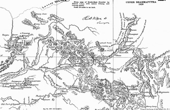
During the Anglo-Burmese War, the question of identifying the source of the Brahmaputra was not merely a scientific pursuit, it was a subject of much “public” interest and discussion under the war conditions created by the advance of Burmese forces right on the frontier of Bengal. In fact, the “Calcutta papers were full of correspondence about the Brahmaputra” (Phillimore Reference Phillimore1954, 53). An article in the Government Gazette of May 9, 1825, advocated the dubious theory that the Tsangpo (forming part of the Brahmaputra system) flowed out through the Irrawaddy in Myanmar, which, of course, was false. There was a wild speculation by a German Orientalist named Heinrich Julius KlaprothFootnote 10 that the Tsangpo and the Irrawaddy were identical. Klaproth actually produced a map of the river that was based on the textual authority of Wilford's On the Ancient Geography of India (1815) and also partly on the Hindu legends concerning the rivers of upper India. Klaproth's paper was read before the Royal Asiatic Society some months before Wilcox embarked on his route survey to “discover” the source of the Brahmaputra. While Wilcox was still busy in the field, Hodgson, the surveyor general, reminded him of the significance of his survey in these words:
A great interest is taken about the Burrampooter and much nonsense issues from the press … Mr. Klaproth, a continental coxcomb, has written that the Sampoo is the Irawuddi, which can hardly be … Pray make all enquiries respecting rivers flowing on the north side of the snowy chain, from west to east, or otherwise. (Phillimore Reference Phillimore1954, 57)
James Rennell had initiated the earliest survey of the Brahmaputra in 1765 when he ventured a short distance north of Goalpara, where the Assam frontier posts stopped him (Phillimore Reference Phillimore1945, 55). Later, Valentine Blacker, surveyor general in Calcutta, and David Scott, political charge of Assam, were anxious to solve the riddle of the Brahmaputra, and in September 1825, Blacker asked Lieutenant Wilcox to be put on special duty to trace “the source of the great body of water which the Brahmaputra pours through Bengal” (Phillimore Reference Phillimore1954, 55–56). Lieutenant Wilcox initially acted as Captain James Bedford's assistant (Wilcox 1832). Bedford reported back in Calcutta on September 6, 1826, thus “leaving Wilcox and others to carry on the good work” (Phillimore Reference Phillimore1954, 55). Wilcox's survey began at Goalpara, Upper Assam, in 1825, and continued till 1830.Footnote 11 In fact, he made a survey of large tracts of geographical spaces that he defined as new “discoveries.” Meanwhile, several British officers employed in the revenue surveys were temporarily taken from those duties and placed in October 1826 under the superintendence of Major John Agustus Schalch with a new task to take advantage of the “opportunities so suddenly and unexpectedly opened” by the first Anglo-Burmese War (Wilcox Reference Wilcox1873, 2).
The involvement of the “subaltern soldiers” was largely visible in the competitive character of nineteenth-century imperial endeavors in the region. There were conflicts and complicity around issues of “advancement of science” versus personal fame and fortune. Sometimes personal rivalries took an upper hand in denigrating genuine talent and even skill. These nineteenth-century surveyors and scientists were largely dominated by their desire to remain useful to the empire.
It may also be pertinent here to mention that neither the route surveys of WilcoxFootnote 12 nor those of Bedford were conclusive, and the Great Trigonometrical Survey of India covered in 1876–77 some parts of Assam (including the course of the Brahmaputra along Dihong) under Captain Woodthorpe and Lieutenant Harman (Black Reference Black1891, 51–52). Out of the Brahmaputra's total length of 2,900 kilometers from its source in Western Tibet to the Bay of Bengal, the Great Trigonometrical Survey sketched on a half-inch scale about 2,413 kilometers of that majestic waterway called the Tsangpo in Tibet, the Siang in Arunachal Pradesh, and the Padma in Bangladesh.Footnote 13
The introduction of “mensural recording” by Lieutenant Harman and Captain Woodthorpe during the 1870s marked a new departure from the earlier narrative surveys and performances of Lieutenant Wilcox and Captain Bedford. Unlike the romanticized accounts of early surveyors, the Trigonometric Surveys moved toward a more abstract understanding of the well-trodden spaces and places along the Brahmaputra. By expending huge resources on the Tsangpo-Brahmaputra riddle, the Indian Survey densely mapped the identity of a river that largely defined “British Assam” and, by extension, the geo-body of Northeast India. Writing in the 1940s in his Discovery of India, Jawaharlal Nehru reassured himself about the Indian identity of the Tsangpo-Brahmaputra, which forces “its way into India through deep chasms cut in the heart of the northeastern mountains,” but his elite nationalist eyes saw it as “rather cut off from the main current of history” ([1946] Reference Nehru2004, 42).
Richard Wilcox's map of the Upper Brahmaputra in 1828 (from R.H. Phillimore, ed. Historical Records of the Survey of India, Vol. 3, 1815–1830, Dehra Dun: Survey of India, Reference Phillimore1954).

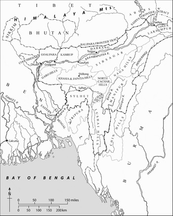
Ludden (Reference Ludden2005) also remarked that “[i]nstead of accepting the nationalization of everything by political boundaries, we can use geographical history to locate current social realities.” The political landscape of this borderland was drawn and redrawn extensively. But the Northeast's more stable historical geography provided the setting for a kaleidoscope of human drama. It provided some elements of continuity amid changes. In colonial Northeast India, imperial surveys and geographical discourses about the identity of a river—the Brahmaputra—had enduring significance. Those early geographical discourses invested British Assam with a new kind of territoriality or territorial identity. By mapping this uncharted geographical terrain, the colonial surveyors actually framed the “geo-body” of the Northeast region. Though that was not the intended effect of British surveying and mapping projects, its cognitive and social impact was no less real. Soon, it dawned on a British census official that there was a gap between cartographic British Assam and the local knowledge about ethnographic Assam (Mullan Reference Mullan1932). While pre-British Assam had embodied the whole of the Brahmaputra Valley since the seventeenth century ad, the map of British Assam loosely included the whole of Northeast India—even SylhetFootnote 14 and the princely state of Manipur.
It has sometimes been casually remarked that India's “Northeast” is an invention of postindependent India to suit its goals of regional development. But this geographical expression appeared to have an older root. For instance, a British military report in Reference Mitchell1883 by Captain St. John Mitchell on upland Assam was titled “The North-East Frontier of India,” and another influential report in 1884 by Alexander Mackenzie referred to “the North-East frontier” of Bengal shown on an Indian Survey map to the scale of 1 inch to 32 miles.
Despite the idea of an anti-Mughal “north-east confederacy” (Dutta Reference Dutta1984, 176), it was British cartography and ethnography that objectified the regional personality of the Northeast borderland. To be precise, British Assam prefigured the “geo-body” of India's Northeast through the technology of maps created by the Survey of India. Thus, Mullan remarked,
Now any ordinary atlas shows the boundary of Assam and hence it is rather surprising to find that many residents in the province when speaking of Assam mean something quite different from the area marked Assam on the map … Even the Calcutta newspapers pay scant attention to our administrative unity … For all practical purposes, therefore, the Assam of this report is exactly the same as it was in 1921. It will be noticed, however, that the areas of the districts differ considerably from those given in previous reports and tables. This is due almost entirely to the fact that a large amount of topographical work has been done in the province by the Survey of India during the last ten years and that there are now up-to-date topographical maps of almost the whole of Assam from which the areas of the districts and subdivisions can be accurately calculated. (1931, 1–2)
Map of British Assam in 1931 (adapted from C. S. Mullan, Census of India 1931, Vol. III, Part I—Report, Shillong, Reference Mullan1932).

In spite of the rich mosaic of nationalities and competing sectional interests, there is a reality to thinking about India's Northeast as a geographical and historical entity and as a cultural unit. This ambivalent yet recognizable quality of “Northeast-ness” is substantially forged by European geographical discourses, especially through the technology of mapping. However, the present focus on mapping the Brahmaputra River, especially its upper course in the uplands, does not at all equate Northeast-ness with only the Brahmaputra Valley. Most rivers naturally connect uplands and lowlands in any borderlands studies.
Cartographic Curtain: Territoriality and Enclavement
As an island nation, early British geographers held a seacoast view of Northeast India: they readily took to the idea of a bounded region demarcated by neat boundary lines constituting a separate inland civilization linked to East and Southeast Asia (Ludden Reference Ludden2005; Robb Reference Robb1997). Colonial cartography endeavored to establish and calibrate exact boundary lines between disparate tribes and their territories. This line of thinking understandably ended up enacting inner and external lines in a border zone of overlapping sovereignties and nationalities. This region of South Asia has been burdened by the profusion of boundaries and fine mapping names of the colonial era such as the Inner Line (1873), the McMahon Line (1914), and Excluded Areas and Partially Excluded Areas (1935). In spite of the claims of absolute sovereignty, the pursuit of firm boundaries largely proved elusive in a “land frontier” such as the Northeast. The indeterminacy of boundaries in colonial Northeast did not reflect the inconsistency of British policy, but the existence of “political volatilities in the region where there were few proto-states to be conquered, and little sense of fixed property” (Robb Reference Robb1997, 250). Confronted by diverse nationalities in a rugged terrain such as colonial Assam, the British Raj embarked on a project of mapping legible state space against illegible, nonstate zones spanning the tribal hills (cf. Scott Reference Scott1999).
The Inner Line Regulation practically cordoned off parts of the Northeast from the outside world. First conceived on January 1, 1873 (and still operative today), the Inner Line covers certain hill tracts of Northeast India.Footnote 15 The anomaly of this demarcation was that it was not an interstate boundary, but an internal one dividing two types of physical terrain and political control within certain provinces of British India. The regulation gave power to the lieutenant governor “to prescribe a line, to be called ‘the inner line,’ … beyond which no British subject of certain classes or foreign residents can pass without a license … which will give the executive Government an effective control” (Mackenzie Reference Mackenzie1884, 56).
The motive behind delimiting an Inner Line was not just to expand British sovereignty, but also to identify British subjects. Related to this was the intention to protect the monopoly of British tea planters in the Assam Valley. It also envisaged a monopolistic control over the brisk trade in pottery, salt, and rubber between the highlanders and the lowlanders.Footnote 16 While the Inner Line evidently augmented colonial control of the seasonal local trade, its supposed benevolence in protecting tribal interest is less evident. By restricting human mobility, the regulation discouraged market activities and relations, however imperfect, in cash and kind. It insulated the hill people, to a degree, from the exploitation of lowland capitalists, but it similarly curtailed tribal access to the lowland markets. In the Lushai hills, for instance, enterprising traders were the first victims of this regulation. In 1883, an official report mentioned that four Lushais had “crossed the inner line and began to tap rubber.”Footnote 17 The four Lushai men were hunted down. The Deputy Commission of Cachar reported that the four Lushais “climbed up some rubber-trees, and while engaged in tapping had been shot down ‘like birds.’”Footnote 18
This piece of colonial legislation encouraged a sense of security as well as insularity. The cultural imprint was so deeply entrenched that it outlived the empire itself. B. P. Singh, a senior Indian civil servant, critiqued the stunted and inhibited influence of the Inner Line's cartographic curtain on the regional personality of the Northeast. Singh lamented that “even the national independence movement could not penetrate into these regions” (Reference Singh1987, 262). The hill areas were sealed off from the Brahmaputra Valley, which entered into dialogue with literate Sanskrit culture and advanced political ideas. In fact, the hill areas of the Northeast were cut off from any traffic of ideas generated by the nineteenth-century Bengal renaissance in the proximity of the tribal hills. Singh, therefore, saw the Inner Line as a policy of “segregation rather than a solution through socialization or adjustment process” (1987, 262). A policy of isolation easily turned into a “husk that blocks anything fresh from coming in” (Bhagwati Reference Bhagwati2004, 265). Singh's stance was a reaction to the rather romantic idea that tribal identity could be preserved, frozen, and fixed in time like a museum showpiece.
The imperial policy of exclusion in the Northeast was perhaps shaped by colonial guilt that awakened uncanny revelations about the impact of the state on the tribal communities—the pacified enemies of the state. One after another, the hill polities in the Northeast succumbed to colonial rule: the Jaintia-Khasi hills in 1835, the Garo and Naga hills in 1866, and the Lushai hills as well as Manipur in 1891. Not only did the tribal people become “incorporated in a state for the first time in their history, they also became minorities overnight” (Schendel Reference Schendel1992, 109), but also, as the colonial state climbed the hills, the local societies would never be the same again. Until the advent of a territorial state in the form of the Raj, the lowland and highland communities maintained a stable “hill–valley” symbiosis through traditional routes of human movement. The highlanders—dreaded as “headhunters”—often succeeded in imposing their interests on the lowlanders. At times, the power equation in the old regimes favored the strategically located hill people, who would impose their will on the valley people, but they had often been obliged to pay homage to the lowland empires (Kirk Reference Kirk1962, 156). The atrophy of the Ahom hegemony in the eighteenth century had tilted the balance of power in favor of the tribal fringe against settled agriculture. The coming of the Raj, however, reversed the political relationship between the hill and valley societies.
On the basis of abiding ecological and economic distinctions, Leach broadly categorized this frontier into two: “hill people” who practiced swidden cultivation, and “valley people” who practiced wet rice cultivation in the Barak-Brahmaputra basin (1960, 51–53). But making due allowances for the distinct ecology and economy underpinning the hill–valley divide,Footnote 19 Scott (Reference Scott1999) persuasively argued that the valley makes the hill, and vice versa. He considers the frontier a site that is always being produced by state-making projects in the valley kingdoms and by the nation-building projects of modern developmental regimes. This explains why the essentialist category of “hill–valley” difference remains historically so salient in spite of the human movement, demographic exchange,Footnote 20 and economic traffic between them, especially in the precolonial period. To quote Scott,
Here is the paradox, I think: the hill-valley social divide has, we know, been crossed in both directions by countless numbers … That is, hill peoples are becoming valley peoples all the time. Valley peoples are running away to the hills all the time. Nonetheless the cultural divide between the hill and valley is stunningly constant as an experienced and lived essentialism. (1999, 3, 6)
The cartographic template of the Inner Line's exclusivist vision found a sharper expression in the “Excluded” and “Partially Excluded” areas of the 1935 Government Act, which laid out a blueprint for the transfer of power to an independent India. The federal ethos of the act thwarted the totalizing dream of the nationalist elites. The act included two provisions related to India's tribal belts, which were declared “Excluded” and “Partially Excluded” areas on March 3, 1936 (Kirk Reference Kirk1962), and they were insulated from the control of the Indian legislatures and ministries. These exceptions constituted a broad internal frontier of the British Raj that not only tolerated but encouraged “realms of transitional sovereignty … beyond which general procedures or rules are tempered or inoperative” (Robb Reference Robb1997, 250). The excluded areas were to be directly administered by the provincial governor—“always British, usually an ICS officer” (Guha Reference Guha1996, 2375). The provision of the 1935 act enjoyed the support of British conservative MPs in the House of Commons. Even Winston Churchill lent his weight to it, saying,
I take as much interest in the fortunes of the white people in India as I would in these backward tribes. I feel just as disturbed about their police and security being handed over to a Government which I do not trust as the anthropological party represented here … about the handing over of the backward areas to a Government they do not trust.Footnote 21
From a subaltern perspective, the Government of India Act had the merit of provoking intense debate about the “tribal question” in late colonial India. At the center of this controversy was Verrier Elwin, who had become, by then, “the most important single influence through whom urban Indians had got to know their tribal countrymen” (Guha Reference Guha1996, 2375). The provision about the excluded areas was much resented in nationalist circles. At its Faizpur meeting in September 1936, the Indian National Congress condemned it as “yet another attempt to divide the people of India into different groups, with unjustifiable and, discriminatory treatment.” It appeared that nationalist fixation on irreducible Indian essence left no room for Elwin's enunciation of tribal autonomy and his legitimate concern that aboriginal tribes “might not be wholly or fairly represented in the (once) hegemonic ideology of Indian nationalism” (Guha Reference Guha1996, 2385). All the same, this quintessentially colonial project of enclavement was remarkably ill conceived to accommodate emerging tribal interests. In the long run, such a paternalistic policy of creating ethnic enclaves rendered their fancied road to modernity even bumpier. Indeed, a fine balance is possible between the pitfalls of a purely protectionist isolation and a crudely interventionist policy.
Cartographic Aggression: Fluid Frontiers into Boundary Lines
Distinct from the internal boundaries delineated by the Inner Line and the excluded areas, the McMahon Line is an external boundary that endeavors to transform a vast expanse of open frontier zone into a fixed line. It set a tentative, but significant, benchmark in the long process of boundary making in the Inner Asian borderland of India (Kirk Reference Kirk1962). At the Simla convention, Sir Arthur Henry McMahon in 1914 projected on a modern map a “scientific” boundary—shown as a red line in the 1914 map—along the crest-cum-watershed line of the Assam Himalayas to the Tawang Tract that runs neatly from Bhutan to Burma (Mehra Reference Mehra2007).
The plenipotentiaries of China, Tibet, and India initialed the map, but the then-newborn Chinese republic refused to ratify it. From that time on, the McMahon Line has been a fruitful source of disputes between India and China (Gupta Reference Gupta1971; Lamb Reference Lamb1966; Mehra Reference Mehra1972). According to Parshotam Mehra, the boundary conflict arose primarily because of two different concepts—the Chinese one of strategic boundary informed by pragmatic concerns, the Indian one of historic borders that underpinned its national identity (2007, 257, 301). Mehra further claimed that “the McMahon Line was drawn after the most careful of surveys by British surveyors … and put on the Survey of India map sheets as late as January 1924” (2007, 237). But that does not mean that it has been surveyed and demarcated on the ground. Neither the crest line nor the watershed principle proves readily applicable in the Assam Himalayas. In this sense, the McMahon Line is a functional but fictitious work of cartography. Early maps, such as the Postal Map of China (1917) published by the government, and China in the Days of the Ching Dynasty published by the University of Peking in 1925, largely conformed to the McMahon Line (Kirk Reference Kirk1962, 140). Chinese maps after 1930 showed the Sino-Indian boundary line as roughly parallel to the McMahon Line, but deviated by moving in a northeasterly direction from the southeast (as opposed to the McMahon Line's northeast) corner of Bhutan (Steiner Reference Steiner1959, 171).
Largely dormant disputes over the McMahon Line were intensified inter alia by the flight of the Dalai Lama into India by crossing the frontier of Assam on March 31, 1959 (Wirsing Reference Wirsing1972). The first incidence of border clash took place on August 7, when the Chinese crossed the Longju control post within the North-East Frontier Agency (NEFA) along the McMahon Line. Six days later, Nehru, India's premier, defended the legitimacy—if not the sanctity—of the McMahon line:
So far as we are concerned, the McMahon Line is the firm frontier—firm by treaty, firm by right, firm by usage and firm by geography. There are minor pockets, small areas in the McMahon Line by way of frontier, where arguments have actually arisen. It was a question of a mile or two this way or that other … These arguments do not affect the major frontier line called the McMahon Line.Footnote 22
Nehru was particularly annoyed by the Chinese refusal to clarify what he perceived as its “cartographic aggression”Footnote 23 in the border areas of Khinzemane (near Migyitun) and Longju. In this polemical exchange, Chou En-lai's rebuff came in a note to New Delhi (September 8, 1959) that reiterated the Chinese view: “The so-called McMahon Line was a product of the British policy of aggression against the Tibet region of China … and is therefore decidedly illegal.”Footnote 24
The cartographic exchanges and the paper war eventually gave way to the undeclared Indo-Chinese War of 1962. It was a rare example of disputed cartographic claims becoming a political turf war. Both sides resorted to maps to support their boundary claims and accused each other of cartographic aggression. In the early hours of October 20, 1962, China decided to strike India both at its western Ladakh and eastern NEFA frontiers. It occupied Longju and Tawang. The Red Army also trapped an Indian division by cycling around the Se-La Pass and thereby captured the Indian supply base at “Bomdi-La.” China routed India on the eastern front, pressing beyond the border line claimed in their maps (Retzlaff Reference Retzlaff1963). It could have overwhelmed the plains of Assam. But after humiliating India, China announced a unilateral cease-fire on November 20, 1962, and the withdrawal of troops to the vicinity of the McMahon Line (Retzlaff Reference Retzlaff1963; Wirsing Reference Wirsing1972). Certainly there is room for differences when long-standing border zones narrow to a neat boundary line.
Here, a consideration of conflicting cartographic claims entailed in the Indo-Chinese border dispute cannot but profit from the perspective of the “new history of cartography” to treat map evidence with subtlety. Thongchai Winichakul rightly complained that the absence of definite boundaries in premodern dominions is “not taken seriously, as if it were to some practical or technical reason” (1994, 18). He further insisted that the “geo-body” of a nation (or in this case, a region) is “an effect of geographical discourses whose prime technology is a map” (1994, 17).
Conclusion
Shrinking from a grueling trek into the hills, general surveys of Indian history often leave the Northeast—a perceived periphery or anomaly—“off the map.” Perhaps in reaction, regional historiography tends to swing too far toward Northeastern exceptionalism in search of a shared sectional unity of the tribal fringes. Given its marginal position and blended identity, this borderland readily serves as a site of India's negation—seen through blinkered yet oppressively neat “chauvinistic, nationalist categories.” As a fluid borderland of Inner Asia, it is difficult to locate India's Northeast exclusively in either East Asia or South Asia.
This paper adopts a convergent approach that registers the creative tension between indigenous ways of picturing the world and European cartographic culture. Unlike the boundary-laden maps of the Indian Survey, cosmological concepts of space and indigenous maps represented a different way of seeing the world: they were remarkably tolerant of overlapping sovereignties, especially along indeterminate border zones. Notwithstanding their practical utility, all maps or map-like models are still “value-laden representations, works of art as much as technical constructions” (Dennis Reference Dennis1991, 280). Power relations between the colonial state and the indigenous regimes, in turn, informed different conceptualizations of space and geographical discourse.
History bears witness to the protracted struggle of the imperial Mughals, the British Raj, precolonial Burma, Republican China, and postcolonial India to stabilize—with varying degrees of achievement. This Asian borderland nurtured a few indigenous states in the past and diverse nationalities in the present. The frontier policy of the Mughal Empire to annex the Ahom dominion in Assam met with little success. Under the bold lead of Mir Jumla, the Mughals made a concerted effort to settle the Northeast frontier firmly. In spite of initial military success in Lower Assam, the mir paid grievously for a deficit in his geographical knowledge of upland Assam. The nawab's decision to take his campaign deep into the Ahom hill country proved to be his nemesis. In a way, history repeated itself when an aggressive Burma suddenly appeared in the spring of 1824 at the Northeast frontier, much to the chagrin of the Company Raj in Bengal. It was then that the “Northeast” swung into the ken of a nervous Calcutta. The Anglo-Burmese War provided the context within which imperial surveys emerged in Northeast India. The production of quick maps for military operations was sternly practical and utilitarian in nature.
Ultimately, surveyors and mapmakers objectified the “geo-body” of British Assam in a “spatial fix” and visualized it as Northeast-on-the-map, being produced by the technology of territoriality. Informed by a different cartographic culture, the British Raj fared better than the Mughals in enacting and demarcating the Northeast borderland with both internal and external boundaries. As a successor state of the Raj, the Indian nation-state inherited the imperial boundaries along with its territorial techniques of rule. India's obsession with security interests over the last sixty years ensures the anachronistic survival of internal territorial boundaries shaped by colonial concerns. National cartographic curtains conceal traditional channels of human movement and cross-border connections along Asian borderlands—not boundary lines. In a global village, it cannot but be rewarding to navigate and open such zones of contact inside and beyond national geographies. Thus, colonial cartography introduced a new idiom to naturalize traditional frontiers into colonial borderlands, which, in turn, forged national boundaries.
Acknowledgements
This paper was presented at the Conference on Writing Northeast India, Centre for Historical Studies, Jawaharlal Nehru University, New Delhi, 2009, and at the History Department's Seminar Series at the University of Delhi, 2010. Many thanks for the thoughtful comments of our anonymous referees, JAS editors, colleagues, and others, especially Gunnel Cederlöf, Basudev Chatterji, Anirudh Despande, Amar Farooqui, Charu Gupta, Vikas Gupta, Bodhisattva Kar, Sunil Kumar, David N. Livingstone, David Ludden, Mahesh Rangarajan, and Patricia Uberoi.