INTRODUCTION
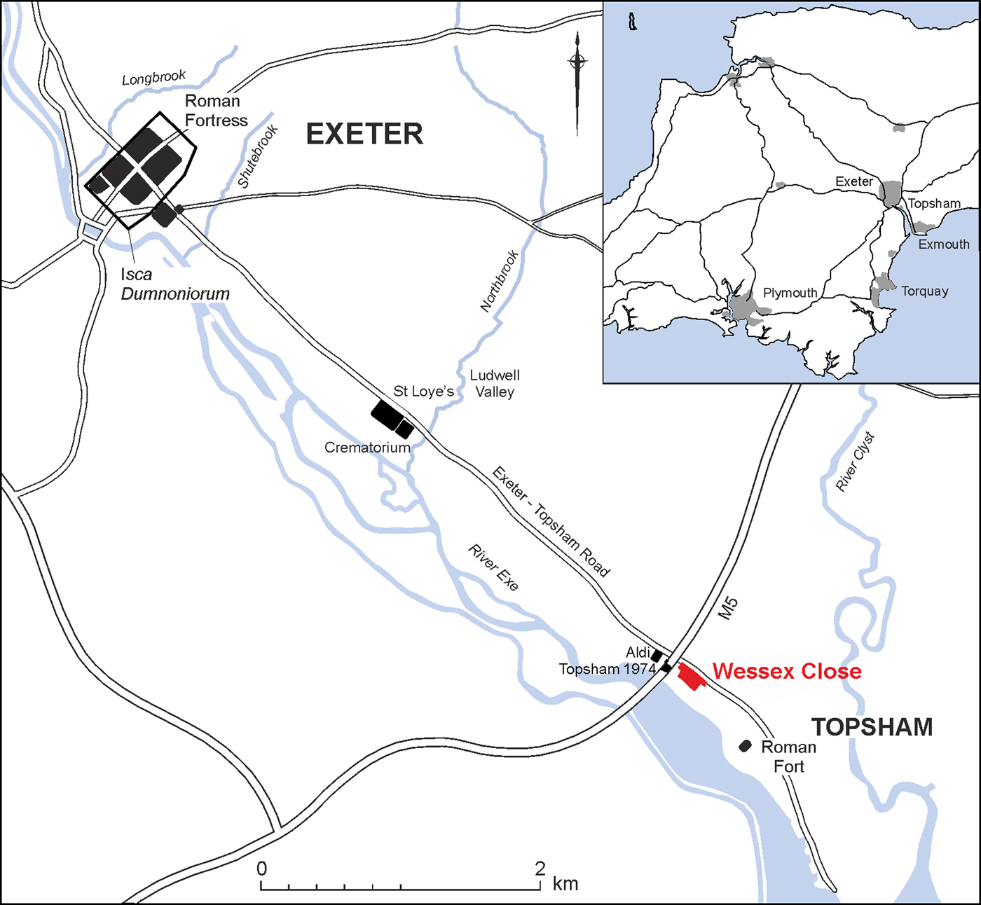
Exeter (Devon) was the most westerly of the principal Roman towns in South-West England and was the only one established within the tribal territory of the Dumnonii; as Isca Dumnoniorum, it was the administrative and commercial capital of the South-West peninsula.Footnote 216 The town was established in the location previously occupied by a legionary fortress which was constructed on a broad sloping spur overlooking the probable lowest bridging point of the river Exe above its estuary.Footnote 217 The road to the north of the Exe between Topsham and Exeter, a distance of 6.5 km, is close to the line of the Roman road between these places; Radford writing in 1937 believed that Topsham (with Exminster on the opposite bank) marked the lowest fording point of the Exe, meaning that sea-going vessels were not able to access Exeter.Footnote 218 Although there is no general agreement in this regard,Footnote 219 it seems probable that the site of Exeter was not accessible at all states of the tide, making the road an important transport link between Roman Exeter and its probable harbour at Topsham.Footnote 220 The via principalis of the fortress continued the line of the road, indicating that the importance of Topsham was already established when the fortress was laid out.Footnote 221 A small first-century building was excavated in 1974 ahead of the construction of the M5 motorwayFootnote 222 and since that time other first-century sites comprising a small fort at Topsham,Footnote 223 a possible military installation at St Loye's,Footnote 224 and military period post-trench structures at the Exeter CrematoriumFootnote 225 and at the Aldi Store siteFootnote 226 have further confirmed the importance of the Topsham to Exeter road (fig. 32).
Location of site in relation to Exeter and other sites mentioned in the text.

Less forthcoming has been evidence for the hinterland of Exeter once the legion was relocated to South Wales in approximately a.d. 75 and the site of the fortress became a town and probable canton capital. Despite the albeit generally piecemeal evidence for the trappings of Roman civil life within Exeter,Footnote 227 during the late second century the town was walled enclosing at its centre a basilica (town hall) built on the site of the former legionary bath-house and the forum (market area) to the south-west of this.Footnote 228 However, the same evidence for Romanisation is not found in the hinterland, with only one definite villa that can be regarded as associated with the town.Footnote 229 In 1987, Todd commented on the absence of villas noting that ‘[i]n this respect Isca was unlike the other civitates of southern Britain’ continuing that ‘[n]o doubt its links with the immediate hinterland were as close as those of any other Romano-British city, but the hinterland was more purely Celtic than Romano-Celtic’.Footnote 230 Three decades of investigation have not altered this picture of a paucity of Romanised farmsteads or settlements in the hinterland of Exeter.Footnote 231 It is in this regard that the current note considers the implications of excavation by AC archaeology between September 2015 and April 2017 of a large later Roman building at Topsham. The large aisled hall is unique in the Exeter hinterland, but hints at the relationship between the city and the coast, if not the wider agricultural hinterland.
DISCUSSION (figs 33–35)
The building (Structure 3) should be regarded as being multi-purpose incorporating aspects of a residence, warehouse and industry, including metal-working, crop processing and fish sauce production. A full report containing the detail of the excavation and specialist analyses is available through the ADS.Footnote 232
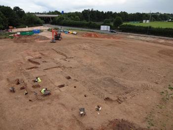
Wessex Close, Topsham. Excavation of a Romano-British building (Structure 3), looking north-west. (Photo: AC archaeology)

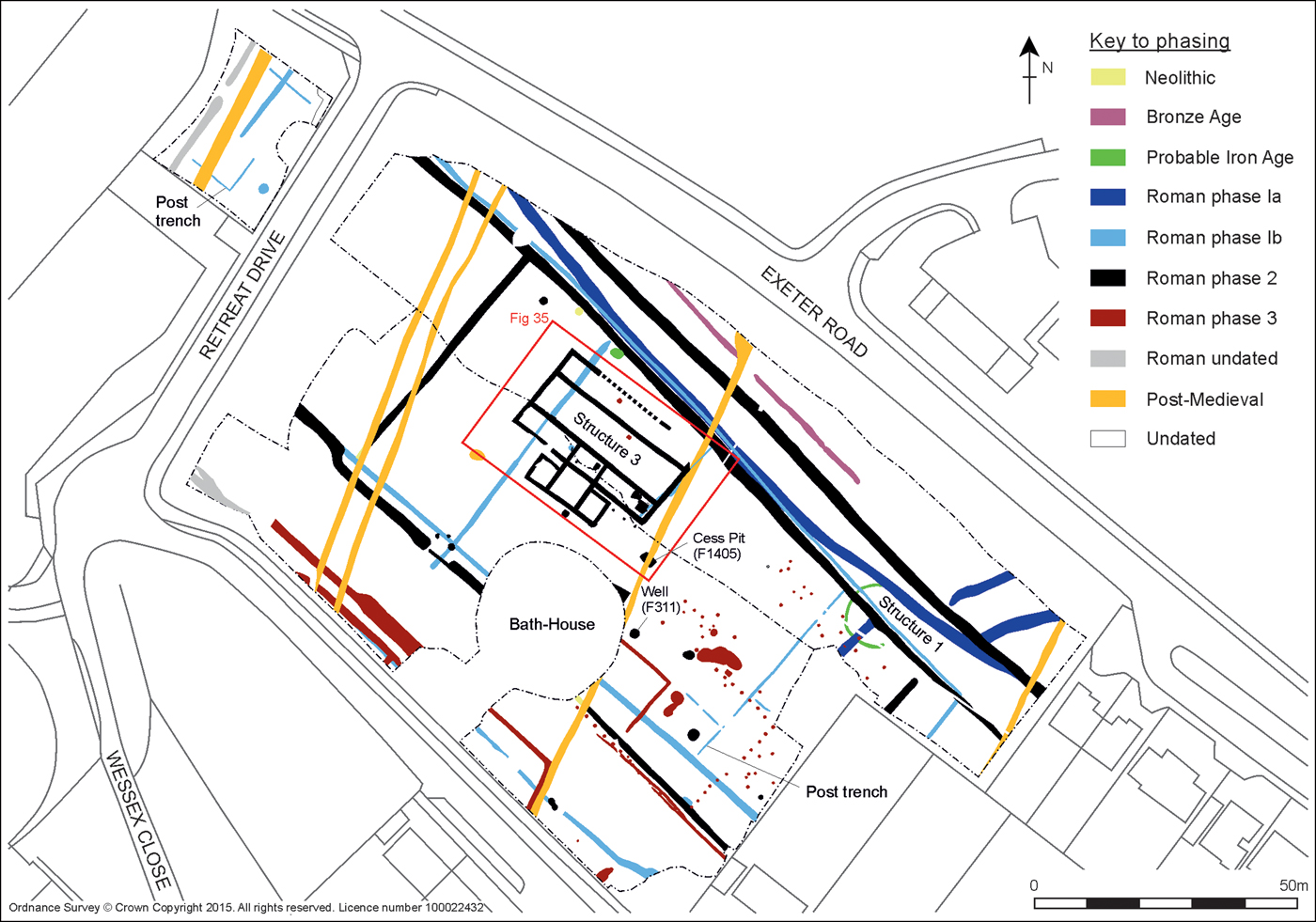
Wessex Close, Topsham. Overall site plan with all phases shown.

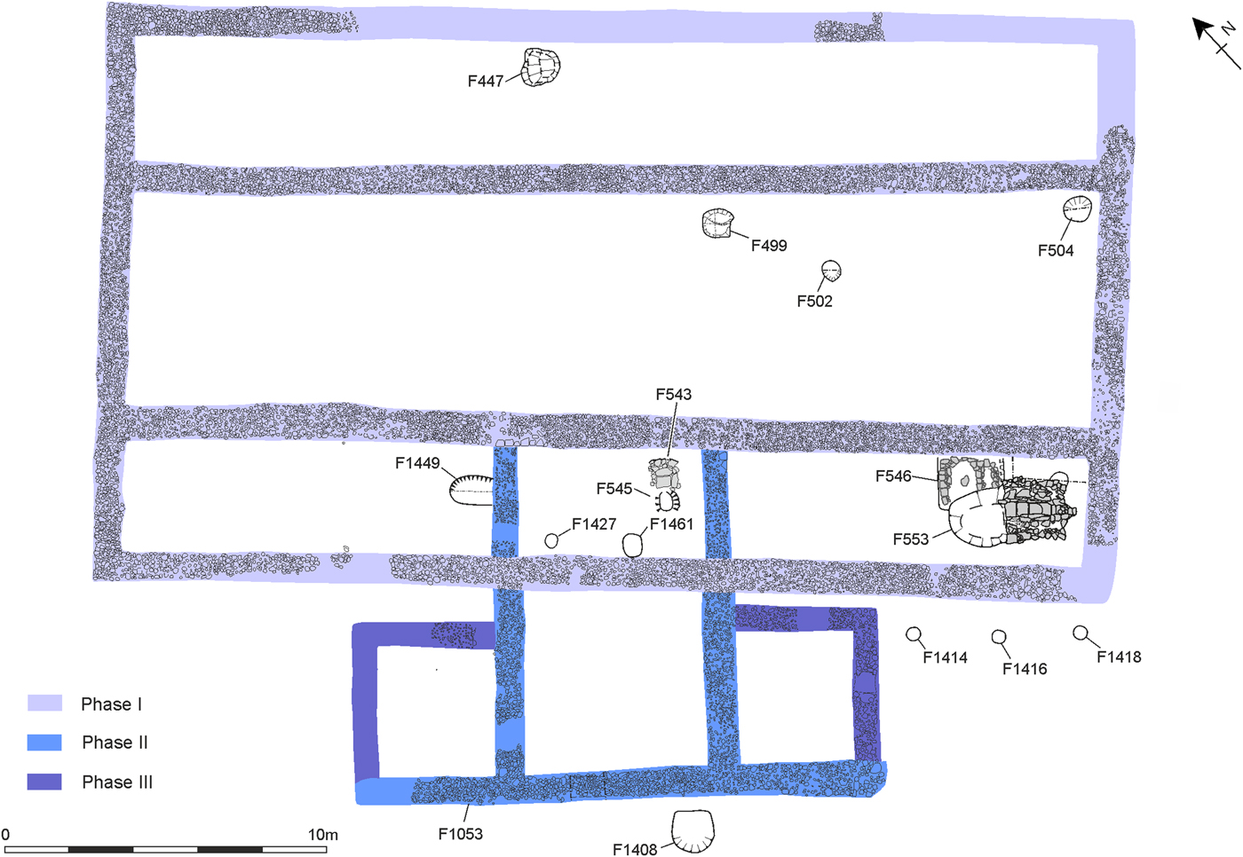
Wessex Close, Topsham. The aisled hall (Structure 3).

A portico extension attached to its south-west side indicates that a building of more grandeur than a simple aisled hall was being presented.Footnote 233 The building has few of the attributes expected of a villa, with no evidence for painted plaster walls, mosaic or tiled floors, hypocausts or glazed windows. A probable bath-house comprising the corner of a subterranean structure lined with four courses of mortared stone blocks with a burnt clay floor, perhaps representing the stoke-hole for a furnace, was in close proximity, but could not be fully explored due to a tree preserved within the development sitting above it. The overall form is broadly consistent with that of an aisled hall featuring a central double-height nave, with narrow single-storey aisles to either side.Footnote 234 How the large internal spaces were organised was not evident, and may have changed over time, but scatters of amphora sherds in the northern aisle perhaps indicate that this was a storage area. The south-east corner room housed ovens.
Aisled halls in Britain vary widely in size with the smallest covering an area of 50–60 m2 and the largest covering an area of up to 800 m2, with those averaging 380 m2 tending to form parts of villa complexes.Footnote 235 Structure 3, with an approximate area of 500 m2, is clearly within the larger range for this building type in Roman Britain, but it is apparent that it was not part of a larger complex of buildings. When not part of a villa complex (typically outside of southern England), aisled halls are found in a variety of locations, namely, farmsteads (51 sites), roadside settlements (17 sites), villages (5 sites) and military vici (3 sites).Footnote 236 Distance from known military establishments and lack of neighbouring buildings means that a village or vicus location can be ruled out, but worthy of further consideration is that this may be the site of a farmstead or positioned in relation to a roadside.
FARMSTEAD
A farmstead has much to recommend it with activities taking place within a rectilinear ditched enclosure measuring 0.5 ha in area and evidence for the processing of wheat and oats on the site. Romano-British farmsteads in Devon are typically defined by stand-alone rectilinear enclosures with a single entrance.Footnote 237 However, at Wessex Close, the enclosure clearly does not stand alone, and appears to be a plot amongst other plots, certainly continuing to the west, with the ditches apparently showing a roadside ‘ladder’ type arrangement. Also of note, and arguing against a farmstead, is that the entrance to the ‘enclosure’ is on the south-west side facing the estuary rather than any farmland that may have existed. The size of Structure 3 also argues against a farmstead as this is a large building in a national context.
ROADSIDE
With parallel ditches the trackway identified in the north of the site is 8–9 m wide and would appear to intersect with the current Exeter road just beyond the site to the north-west. The track follows an alignment which is established by two earlier phases of ditches. There was limited evidence for a thin and insubstantial gravel/metalled surface.Footnote 238
It appears then, that Structure 3 and the plot within which it sits take their orientation from their position adjacent to the track. However, there is no opening to the track, indicating once again that the site faces the estuary, a direction further accentuated by the portico on this side of the building.
HINTERLAND
Buildings with stone foundations located in the hinterland of Roman Exeter are very unusual indeed. However, a building of striking similarity in construction was excavated in the 1930s at what is now Topsham Rugby Club, 430 m east of the site.Footnote 239 It too had riverworn cobble foundations and a slate roof; it dated to the fourth century and also contained two ovens of similar design to those in Structure 3.Footnote 240 It was, however, considerably smaller at approximately 17 m by 8 m, and was interpreted as a bakehouse.
The other Roman buildings with stone foundations outside of Exeter in Devon have largely been interpreted as villas. These are Downes at Crediton, Holcombe, near Lyme Regis, Honeyditches at Seaton and possibly Membury.Footnote 241 The latter three are well beyond the hinterland of Exeter.Footnote 242 At Otterton Point, close to the mouth of the river Otter, 13 km south-east of Topsham, small-scale trenching revealed a simple building with dry-stone foundations and mortared walls above. However, finds and features indicated that a higher status building may be present, and that the inhabitants were exploiting the estuary for the collection of shellfish and salt.Footnote 243
Exeter and its hinterland were founded on a pattern of fortifications, settlements and communications established by the military. In North-West England Taylor has found that the pattern of Roman occupation largely follows that laid down by the military with little effect on the dispersed pattern of indigenous farmsteads that prevailed prior to the invasion.Footnote 244 It appears that a similar situation prevailed in the South-West. It is apparent that Exeter was close to the eastern edge of its tribal territory, whose inhabitants appear to have largely resisted many of the trappings of Roman life. The size of Exeter is typical of several other Romano-British towns;Footnote 245 however, given the circumstances of its location, it may be no surprise if it was different from other towns in the province, and this may be the reason why Exeter does not appear to have a Romanised hinterland.Footnote 246 Some doubt has been cast on the relative success of Exeter; Holbrook in a review of the evidence finds that ‘an area in the core of the town was always devoted to agricultural or horticultural activities’.Footnote 247 In this regard, could it be that Roman Exeter was much more agricultural than many other towns?Footnote 248 This, at least in part, may explain the general paucity of villas and Romanised farms in its hinterland, if a proportion of the town-houses within the city were actually homesteads of the head households of estates. In this scenario, agricultural activities were taking place both in the town and the countryside, with the form that these took in the countryside little changed from that which preceded the invasion, with small un-Romanised farmsteads being the norm throughout the Romano-British period.Footnote 249
In support of a significant role for Exeter in hosting farms, or at the very least, the head households of country estates, some of the findings of the Roman Rural Settlement Project may be regarded as pertinent. For example, it is argued that towns did not have a significant role as a market for products from the countryside; this does not mean that products from the countryside were not being consumed in the towns, which they definitely were, but that they were being supplied directly from country estates or by merchants going directly to villas.Footnote 250 At Exeter, the relationship between town and countryside was probably direct, with agricultural production in the hinterland controlled from the town and not reliant on products from local villa estates. Returning to Wessex Close, how then does the complex here, and Topsham as a port, fit within a changed expectation of the requirements of Exeter's residents?
Although there may have been no or little role for the forum in Exeter to serve as a market for locally produced agricultural products, it did exist and there was clearly a market for exotic products. The products offered for sale to the residents of Exeter must have been portable material culture (e.g. pottery and glassware) from production centres within the province to the east and from the Continent and consumables from small-scale or specialised production or from distant sources. Topsham would have been well placed as an entrepôt for products brought from the Continent and, probably to a lesser extent, by coast from within the province and for the supply of marine products (e.g. shellfish, fish and salt) and specialised production, for example, of fish sauce. The evidence from the Wessex Close complex indicates the import of finewares and mortaria from the Rhineland and eastern Gaul, glassware, possibly from Italy, and foods and flavourings, including coriander and dill seeds and Mediterranean stone pine nut.Footnote 251
Structure 3 was, therefore, in a prime position to exploit both the products of the estuary and the direct trade that access to the sea allowed, and was perhaps the residence of a port official. It was involved in the supply of exotic products to Exeter and the production and supply of consumables derived from the sea. Many of the residents of Exeter must have been directly involved in agricultural production, with the hinterland little changed from pre-invasion patterns of settlement and farming. However, Structure 3 provides a hint that the civilian Romanised elements of the landscape, following a pattern established by the military, contained a hinterland for the supply of exotic products, particularly from the port of Topsham.
ACKNOWLEDGEMENTS
The excavations were commissioned by Clive Rowe and Guy Olliver of Heritage Developments (SW) Ltd and co-ordinated for AC archaeology by John Valentin. The site works were directed by Alex Farnell. The illustrations for this note were prepared by Sarnia Blackmore and Leon Cauchois. Derek Gore provided helpful comments on an early draft of this paper. The collaborative role and advice on site of Andrew Pye, the Exeter City Council Principal Project Manager (Heritage), is duly acknowledged. The finds will be deposited with the Royal Albert Memorial Museum, Exeter and the paper and digital archive with the Archaeology Data Service.