

Due to its multiple Mississippi River tributaries, the state of Iowa has suffered flooding disasters annually. The state has also experienced catastrophic flooding on several occasions. The Great Flood of 1993 covered about 320 000 square miles (840 000 km2) and necessitated the expenditure of $15 billion for the delivery of requisite disaster recovery services.Reference Larson1 The more recent Iowa floods of 2008 will likely prove even more damaging in the long run. In early June of 2008, rain fell on portions of eastern Iowa in quantities that substantially exceeded the region's seasonal averages. On June 8 and 9, more than 4 inches of rain fell in the Cedar River and Iowa River watershed. This accumulation, combined with that of earlier storms and rainfall, resulted in widespread flooding along the Cedar River in Benton, Linn, Johnson, and Cedar counties. In the Cedar Rapids area alone, flood waters crested to over 30 inches, covered approximately 10 square miles, and deposited an estimated 80 000 tons of debris. Altogether, from May to August 2008, the floods resulted in 18 deaths, 106 related injuries and the displacement of some 38 000 persons, and caused approximately $1.5 billion in total economic damages.Reference Larson12 In total, about 85 Iowa counties, covering more than 45 000 square miles, were declared disaster sites.
During the course of these floods, it became necessary for the state health department to conduct rapid needs assessments to quantify the scope and scale of the floods' effects on human health. In response to this need, the Iowa Department of Public Health (IDPH) utilized geographic information systems (GIS) technology to conduct rapid needs assessments to estimate impact of the event on the population. Results of these surveys demonstrated that many households had been temporarily displaced and that inadequate access to prescription medications and the presence of environmental health hazards presented the most significant health risks to flood-affected populations.
BACKGROUND
Flooding is the most common form of natural disaster and is the primary cause of weather-related deaths within the United States.Reference French and Hold3 The effects of flooding disasters are substantial and can include contamination of the available water supply; utility outages; interference with economic activities; infrastructure limitations such as road closures; physical hazards, including downed power lines, sharp or dangerous debris obscured by water, and structural damage to buildings; and ongoing environmental health risks stemming from increased disease vector overgrowths.Reference Landesman4 Additional public health hazards can emerge through the spread of infectious diseases caused by bacteria, viruses, mold, and mildew.Reference Ligon5 Multiple public health system interventions are therefore necessary to mitigate hazards and promote normal community functionality, including the promotion of health care access, active disease prevention and control, risk communication and public education activities, and the coordination of disaster response and capital recovery efforts.6
The success of these public health efforts ultimately hinges upon the timeliness and accuracy of situational awareness.Reference Burkle, Hsu and Loehr7 The first step toward managing the acute needs of a disaster-affected population requires the collection of information pertaining to the extent of the acute disruption to the public's health.Reference Lillibridge, Noji and Burkle8 It is often necessary to rely on methods such as the undertaking of rapid needs assessments to acquire this information.Reference Guha-Sapir9 Unfortunately, traditional social science and public health research methods often prove too time- and resource-intensive to adequately fulfill the needs of disaster response coordinators.Reference Vlassoff and Tanner10 The first step towards managing the acute needs of a disaster-affected population requires the collection of information pertaining to the extent of the acute disruption to the public’s health.Reference Lillibridge, Noji and Burkle8 Unfortunately, traditional social science and public health research methods often prove too time- and resource-intensive to adequately fulfill the needs of disaster response coordinators.Reference Vlassoff and Tanner10 Rapid needs assessments, however, are one method by which response coordinators can quickly acquire the information.Reference Guha-Sapir9 Such assessments typically consist of the rapid surveying of affected areas to identify at-risk populations, as well as efforts to conduct timely epidemiological assessments and identify the immediate medical and relief needs of disaster victims.Reference Smith11 Extending beyond the initial assessment, the use of rapid assessment tools is necessary for the continual monitoring and evaluation of response efforts.Reference Bradt and Drummond12
The efficacy of rapid needs assessment procedures under disaster conditions has improved significantly through the incorporation of GIS technologies.Reference Zerger and Smith13 The use of GIS-integrated modeling frequently begins with the identification of the survey area, the incorporation of census tract data via GIS software packages, and the random selection of sampling clusters. This is followed by the collection and analysis of data gathered from the selected populations.Reference Waring, Zakos-Feliberti, Wood, Stone, Padgett and Arafat14 The results of GIS analysis can aid public health authorities in estimating the impact of disasters and establishing preparation, response, recovery, and evacuation plans, in addition to promoting recovery efforts by tracking disease outbreaks or assisting health emergency operations centers in locating and effectively allocating available resources.Reference Johnson15
METHODS
In response to the developing hazards, the Iowa Department of Public Health (IDPH) quickly undertook a GIS-based, rapid needs assessment to estimate the public health impact and significant human needs that resulted from the flooding. This effort was facilitated by interview teams and staff from IDPH, in partnership with the Florida Department of Health and the North Carolina Division of Public Health with whom IDPH had pre-existing emergency management assistance agreements. Response teams from each of these departments conducted the necessary surveys. The data were then analyzed by Iowa and North Carolina team members and then disseminated to local authorities by IDPH staff.
The use of randomized, purposive sampling techniques is recognized as an appropriate means of conducting a rapid needs assessment under disaster conditions.Reference Weiss, Boldto and Snakar16 Cluster-sampling survey techniques may yield timely estimates of the number of individuals affected by a disaster, and illuminate the specific needs of this population.Reference Malilay, Flanders and Brogan17 In this instance, the Community Assessment for Public Health Emergency Response (CASPER) instruments, as provided by the North Carolina Division of Public Health, were utilized as primary means of data collection (refer to the online appendix to view the CASPER instruments). These surveys were targeted at primary flooding sites, which were subdivided into randomized observational units using GIS software. Within each of these GIS-identified areas, field teams purposively sampled a randomly selected cohort of households in order to assess the scope and scale of the floods' effects on human health.
The initial assessment began with the development of a map of Cedar Rapids that estimated the Cedar River flood boundary within the city limits. The area contained in the flood zone was selected by IDPH as the community assessment area. GIS and year 2000 census data were used to identify characteristics of the census blocks within the assessment area. After excluding blocks with fewer than 20 households to expedite the survey, 30 census blocks were randomly selected from the population of 78 remaining blocks with probability of selection proportionate to the number of occupied housing units in the census block. Seven spatially random points were then identified within each of the 30 blocks. Ten interview teams used GPS-equipped, handheld computers to navigate to each of the points in the assigned census blocks. Interviewers identified the household closest to the point and attempted to conduct face-to-face interviews with a member of that household. Ultimately, the interview teams completed interviews with members of 214 households within the Cedar Rapids area.
A subsequent assessment was also conducted within affected rural areas, which included Benton, Linn, Johnson and Cedar counties. However, the comparatively low population levels within the selected assessment areas precluded the use of the modified cluster sampling technique that had been used for the Cedar Rapids assessment. Instead, a simple random sample of households from the four counties was selected. Using GIS systems software, 200 spatially random points were generated within the assessment area. Ten interview teams were directed to the points using GPS-equipped handheld computers. The teams were instructed to identify the household closest to the point to attempt to conduct face-to-face interviews with a member of that household. After more than 10 hours of attempts to identify household members to interview in the four counties, the interview teams were able to collect a total of 111 interviews. Because it became clear relatively early in the day that the sample target of 200 household interviews would not be reached, interview teams were instructed to canvass the communities located in the assessment area in order to collect as many household interviews as possible. In effect, the rural component of this assessment effort consisted largely of convenience sampling as a result of the difficulties inherent in conducting a truly randomized sampling methodology in a rural locale.
FINDINGS
The rapid needs assessment indicated the flooding events had a significant impact upon affected populations. The most prevalent concerns pertained to immediate human needs, such as access to housing, utilities, food, and drinking water. Additional long-term concerns included care for injuries, access to health care, and protection from environmental health hazards.
Impact on Food, Housing, and Utility Needs
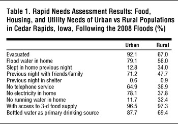
In the urban Cedar Rapids survey area, approximately 92.1% of homes had been evacuated due to flooding; 79.1% of homes in the assessment area had experienced flood water incursion into the living area of the home (Table 1). As a result, only 12.8% of residents reported sleeping in their home the previous night, while 71.2% of households reported spending the night with friends/family, and an additional 0.6% of households reported relocating to shelters. Following the flood, 64.9% of households reported having no telephones services, 78.1% reported no electricity, and 11.7% had no running water in their homes. Fortunately, 96.5% of households reported that they had access to a 3-day supply of food and 87.7% were utilizing bottled water as their primary source of drinking water.
Rapid Needs Assessment Results: Food, Housing, and Utility Needs of Urban vs Rural Populations in Cedar Rapids, Iowa, Following the 2008 Floods (%)

By comparison, an estimated 67% of homes in the rural assessment area were evacuated for flooding and 56% had floodwater incursion into the living area of the home (Table 1). Of rural residents, 34% of respondents reported having slept in their home the previous night, while 47.7% had spent the night with friends and family, and 0.9% had resided in shelters. Overall, 36.9% of surveyed households lacked working telephone service, 37.8% were left without electricity, and 32.4% had no running water. At the time of the survey, 69.4% of households were utilizing bottled water as their primary source of drinking water and 97.3% had access to at least a 3-day supply of food.
Impact Upon Medical and Healthcare Needs
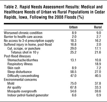
In general, the aggregate data did not indicate increased illness or injury rates as a result of the floods. However, 8.9% of respondents in the urban Cedar Rapids area reported the worsening of a chronic condition of someone within their household. Furthermore, approximately 16.8% of urban respondents reported that at least one household member had suffered some form of injury in their home following the flood. Of those who suffered an injury, 29.0% were cuts, scrapes, or puncture wounds. A total of 13.1% of households reported incidences of stomachache/diarrhea, 8.9% reported skin rashes, 58.5% reported sleep disturbances, and 47.0% of households responded that a family member had incurred difficulty concentrating since the flood.
Within the rural cohort, 9.0% of respondents reported the worsening of a chronic condition following the flooding incident (Table 2). Approximately 2% of households reported at least one household injury since the flood, with 17.1% of injured respondents reporting a cut, scrape, or puncture wound. Respondents also reported incidence of illness following the flood. About 19% of respondents indicated onset of respiratory problems for at least one member of their household, 10.8% reported stomachache/diarrhea, 7.2% skin rash, 27.0% sleep disturbances, and 40.5% reported concentration difficulties.
Rapid Needs Assessment Results: Medical and Healthcare Needs of Urban vs Rural Populations in Cedar Rapids, Iowa, Following the 2008 Floods (%)

Despite these consequences, it does not appear that flooding circumstances had significant impact upon the health care delivery system within affected areas. Only 2.0% of urban households and 2.7% of rural households reported flood-related barriers to health care access. The more pressing concern at the time of the survey proved to be access to prescription medication. A significant number of households reported that at least one individual lacked access to a 3-day supply of prescription medications (18.3% of urban households and 16.2% of rural households). Furthermore, the results indicated that of those respondents who had reported a cut, scrape, or skin abrasion following the flood, few had received tetanus shots within the past 10 years (25.2% urban and 21.6% rural).
Finally, survey data also indicated that health effects due to flooding may be amplified through the presence of environmental hazards, which can either cause new illness or exacerbate existing conditions. Mold and air quality concerns, for example, were very frequently cited among both urban and rural respondents. Mold concerns were reported by 75.0% of urban participants and 37.8% of rural participants. General air quality was cited as a concern within 67.8% of urban households and 33.3% of rural homes. Urban and rural households also reported vulnerability to health risks stemming from mosquito overgrowth (54.6% and 59.6%) and the reliance upon indoor petroleum-fueled generators for power (6.6% and 0.9%).
DISCUSSION
The implementation of rapid needs assessments revealed that both urban and rural residents were faced with significant needs pertaining to the accessibility of housing and utilities. It is notable fewer urban residents whose homes were flooded remained in their residences overnight as compared to their rural counterparts. The majority of both urban and rural respondents who evacuated reported having stayed with friends and family members; relatively few households in either cohort chose to spend the night in an emergency shelter. Further research may be indicated to look for any baseline differences in individuals relocating to shelter facilities and those who did not as the low levels of shelter utilization may be indicative of barriers to shelter access, low levels of awareness regarding the availability of shelters, or a general unwillingness to utilize shelter facilities when alternate dwellings are available.
Experiences during the 2008 Iowa floods emphasize the need for ongoing disaster education at the population level. Specifically, members of the public must be reminded that they need to keep adequate stock of prescription medications in order to avert potentially serious long-term health consequences.18 This message must also be reinforced among members of vulnerable populations such as the elderly, chronically diseased, and expectant mothers, who are at greatest risk for severe health consequences as the result of disrupted access to prescription medications.Reference Brodie, Weltzien, Altman, Blendon and Benson19Reference Jhung, Shehab and Rohr-Allegrini20 The Iowa Department of Public Health has taken efforts to address these needs, including providing broadly targeted emergency preparedness information for the public at http://www.protectiowahealth.org/ and instituting a state-wide Emergency Preparedness Public Education Campaign.
Effective disaster management practices also require public health authorities to properly inform affected individuals as to how they may reduce their own exposure to risk.Reference Domres, Koch, Manger and Becker21 The data collected following the Iowa flooding disasters suggest that citizens appear to require more in-depth education regarding the mitigation of environmental health hazards, particularly vector management, immunization against tetanus, and the use of petroleum-powered appliances within confined locations. Additional warnings should also be provided regarding the potential dangers posed by non-potable drinking water and contaminated foods. Such risk communications must be adequately targeted to address the relevant risks faced by the population and delivered in a manner that is understandable, meaningful, and actionable.Reference Calman22 Furthermore, future applications of rapid needs assessment methodologies should inquire as to whether respondents had in fact received appropriate risk communications and if they were able to utilize the information to mitigate personal risk exposures.
In addition, the floods’ impact upon individuals' psychological health indicates that state and local health departments must be prepared to deal with incident sequelea. Although reports of distractibility and sleep disturbances do not constitute valid clinical diagnoses, local health systems will require an effective means of screening affected populations and facilitating the receipt of follow-up care. Contingency plans will also be needed to ensure that human medical needs can be met in the event that local demand exceeds available capacity.Reference Bostick, Subbarao, Burkle, Hsu, Armstrong and James23 Basic public health campaigns should also be adopted to increase population resilience.Reference Norris, Stevens, Pfefferbaum, Wyche and Pfefferbaum24
Finally, it should be acknowledged that additional efforts will be needed to ensure that disaster-affected populations can access recovery resources even when such needs have been identified and appropriate recovery resources have been made available. Research following the1993 Great Flood in Iowa has suggested that many needy individuals eligible for recovery assistance were either unwilling or unable to pursue available aid resources.Reference Stimpson, Wilson and Jeffries25 This evidence indicates that disaster planners must make explicit efforts to reduce barriers to accessing recovery services, including addressing communication and transportation issues that may preclude individuals from seeking aid as well as ensuring adequate access to health care services and the availability of medical records.Reference Subbarao, Bostick and James26
In summary, the GIS-based rapid needs assessment exercise was effective in helping the Iowa Department of Public Health to ascertain the immediate human impact of the flooding events of 2008. However, the need remains to continue utilizing GIS-based survey techniques to monitor the health status and health care needs of affected households, the allocation of available recovery services, as well as the overall evaluation of response efforts to improve pre-disaster planning in advance of future events. In order to be maximally beneficial, further research and consensus regarding the minimum data elements for risk assessment surveys is necessary.
LIMITATIONS
The information collected by the Iowa Public Health Assessment Teams (PHATs) was subject to certain limitations. For instance, PHATs were limited in their ability to collect information due to logistical constraints. These included the need for a large cohort of properly trained personnel to obtain survey data, particularly within the sparsely-populated rural areas of the state. The physical barriers resulting from the floods themselves, such as inaccessible roads, additionally imposed further barriers. For these reasons, it not possible to undertake a rapid needs assessment of all affected areas by means of a truly random GIS sampling methodology. Instead, field responders were forced to rely upon a convenience sampling of available households. It is not possible to calculate how the results gathered via a convenience sampling might differ from those gained through a truly random sample, but such a discussion may be largely academic as obstacles such as inaccessible roads make adherence to methodology daunting, if not impossible.
Another hurdle for responders was the lack of consensus-based minimum data elements for use in undertaking rapid needs assessments. The development of such a protocol will be essential for facilitating inter-agency disaster response and relief coordination activities, as well as to ensure that the information collected is adequately robust to assess a population's health status and medical needs.Reference Bradt and Drummond27 Further research is clearly warranted to better enable public health authorities to promote timely and actionable emergency needs assessments.
As a follow-up to this study, additional research efforts should examine potential baseline differences between individuals relocating to shelter facilities vs those who did not. Such research into low levels of shelter utilization may be indicative of barriers to shelter access, low levels of awareness regarding the availability of shelters, or a general unwillingness to utilize shelter facilities when alternate dwellings are available. Moreover, future needs assessments should include the surveying of shelter inhabitants to ensure that public health facilities are able to meet the medical and physical needs of occupants.
CONCLUSION
In response to developing hazards, the Iowa Department of Public Health mobilized interview teams and staff from IDPH, the Florida Department of Health, and the North Carolina Division of Public Health to conduct assessments to estimate the public health impact and significant human needs that resulted from the flooding. While these assessments did not reveal significant levels of acute injuries resulting from the flood, they did show that many households had been temporarily displaced and that future health risks may emerge as the result of inadequate access to prescription medications or the presence of environmental health hazards. Overall, use of the rapid needs assessment survey following the Iowa floods of 2008 highlighted the need for improved risk communication measures and ongoing post-event public health surveillance and relief measures. The utility of rapid needs assessment survey tools is apparent, and their use after disasters or public health emergencies should become increasingly widespread.
Acknowledgments: The authors of this paper would like to thank individuals from the following organizations for their support and assistance: the Iowa Department of Public Health; Florida Department of Public Health; North Carolina Department of Public Health; Benton County Public Health Department; Butler County Public Health Department; Cedar County Public Health Department; Floyd County Public Health Department; Johnson County Public Health Department; Linn County Public Health Department; and the Iowa Homeland Security and Emergency Management Division.