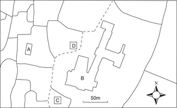


The Nazareth Archaeological Project was a British archaeological research project investigating Roman-period and Byzantine Nazareth and its hinterland, in the Lower Galilee region of northern Israel. Beginning in 2004 with a survey of the countryside north of the present city, in 2006 the focus of the project shifted to the Sisters of Nazareth convent (hereafter referred to as ‘the convent’), a European Roman Catholic house in the very centre of Nazareth, some 100m north west of the famous Church of the Annunciation (fig 1).Footnote 1 The archaeological data recorded at the convent are exceptionally rich and cover a wide chronological range, offering what is probably the best stratigraphical sequence we have from central Nazareth. This paper provides an interim report on the Early Roman-period phases of the site, summarizing data relevant only to these phases.Footnote 2
Central Nazareth, showing main streets in solid black lines and the probable approximate line of the wadi as a broken line, using present streets built above its infill as a guide. Key: A = outline of the cellar at the Sisters of Nazareth convent; B = outline of the present Church of the Annunciation (on south), Franciscan buildings (in centre and to east) and St Joseph's church (on north); C = first-century tomb close to the Church of the Annunciation; D = Israel Antiquities Authority excavation at the International Marian Center. The locations of both C and D are approximate only as their precise positions are unpublished. Drawing: author

The initial aim of the project was to chart the cultural and economic effects on surrounding rural communities of the transformation of a Roman-period Jewish village into a Byzantine Christian pilgrimage centre.Footnote 3 Work in the countryside suggested that the rise of Nazareth as a Christian pilgrimage centre had indeed altered the culture, and perhaps the economy, of the Jewish farming settlements in its northern hinterland.Footnote 4 With the primary aim of the project met, a site was sought that could provide data from the centre of Byzantine Nazareth (as identified by the presence of the Byzantine Church of the Annunciation) to complement data from the countryside survey. The Sisters of Nazareth convent was selected for this purpose, with the further objectives of bringing to publication previously unpublished archaeological work at the convent site and reinvestigating it using twenty-first-century archaeological methods.Footnote 5
Investigation of the convent site prior to 2006
When, in 1881, the Sisters of Nazareth bought the land on which the present convent stands, local residents claimed that it had once been the site of a ‘great church’ and the ‘tomb of a saint’.Footnote 6 These stories, which one might initially assume fanciful or even invented for the purposes of negotiating the price, excited much interest among the nuns. Then, on 18 October 1884,Footnote 7 small-scale maintenance work on a cistern revealed a subterranean rectilinear room roofed with a well-constructed cross-vault. This room led to a series of other underground spaces, partially or wholly filled with soil. These underground rooms were ‘excavated’ by the convent staff, pupils of the convent school, local workmen and clergy, in the course of the late nineteenth and early twentieth centuries.Footnote 8 A purpose-built cellar was constructed to contain many of the sub-surface features, with a small museum above it to house the many finds. The latter include Roman-period, Byzantine and Crusader coins, metalwork, pottery, glass and Byzantine and Crusader architectural stonework, such as column capitals and column shafts.
These subterranean discoveries were put in context when the convent was rebuilt c 1900, revealing the surface-level walls of a Byzantine church. It is a credit to the Sisters that they had these walls carefully planned by the architects involved in the rebuilding. That plan suggests an east–west, triple-apsed structure, with a small single-apsed chapel later added to its south-eastern end. These structures were ashlar-built and mosaic-floored, with polychrome wall mosaics and marble architectural details. A well-preserved cave-church, similarly afforded polychrome wall mosaics and marble fittings but without a floor mosaic, was constructed to the north of the northernmost tomb discussed here (Tomb 2) and the whole remaining area of the present cellar vaulted as a large crypt beneath the surface-level church. This surface-level building, probably the largest building in Byzantine Nazareth, was refurbished (after a phase of disuse) in the Crusader period. It was destroyed by fire in the late twelfth or thirteenth century.Footnote 9
Most of the nineteenth-century work, both on the surface and below, was undertaken by casually digging out soil until natural rock, solid floors or stone-built features were found, often with only limited recording. However, Henri Senès, a Jesuit priest who had been an architect prior to his ordination, began recording the site in a more systematic fashion from 1936.Footnote 10 Even by the standards of the late 1930s, Senès was not at the forefront of archaeological method, but this was a considerable improvement on previous clearance at the site as he made detailed measured drawings and labelled finds in relation to architectural features.
In the meantime, an extensive literature on these discoveries grew up, much of it highly speculative.Footnote 11 This has undoubtedly deflected scholars away from the importance of the site, and understandably led to a degree of caution on the part of the Sisters of Nazareth themselves. Indeed, the most important archaeological study of the site to be published prior to World War II is a youthful work by Bagatti,Footnote 12 later famous as the excavator of the Church of the Annunciation. Bagatti's interpretation was based on an inaccurate plan, without taking account of the range of finds in the museum and without using the records of earlier scholars in the convent archive.Footnote 13 This led to the site being all but ignored or dismissed by the majority of scholars,Footnote 14 while appearing on maps of Early Roman-period burials in Nazareth. Domestic occupation was felt especially unlikely, having been proposed on insecure grounds by previous speculative writers, and this has distracted recent scholars from identifying the actual evidence of domestic use, as we shall see later. An attempt, in 1980, by Livio to counter Bagatti's arguments, and to offer an interpretation of the site using a fuller (but even then, far from a full) range of data, is marred by inaccurate reporting of earlier records, an inaccurate plan and a stratigraphical misunderstanding.Footnote 15 Otherwise, the most detailed reports of the site so far are by otherwise unknown scholars: Soeur Marie de Nazareth and Sister Renée Desmarais.Footnote 16
Most other twentieth-century studies of the site went without record, and even their existence is known only through the convent archive or the Sisters’ memories. For example, it is only because a copy was deposited with the convent that we are aware that the late Dr Eugenia Nitowski (then a Carmelite nun), who had formerly been an archaeologist, wrote a short research proposal for future archaeological study after a brief examination of the visible structures in 1987, a proposal that was never put into action nor published. Between 1884 and 2006 the only secular scholar to publish on the site was Schumacher,Footnote 17 who visited it in the late 1880s to try to identify a well on the site. Schumacher's 1889 paper includes a description and schematic plan of what he saw, and drawings of a few of the more complete artefacts, but this was before much of the site was excavated and his plan was made in near-darkness.
With so little published on the site, and all the published descriptions and plans showing omissions and serious inaccuracies, the principal evidence for the site in 2006, therefore, was the series of rock-cut and built features exposed by earlier work, enclosed in a purpose-built cellar, and the finds and records in the convent.
Archaeological recording 2006–10
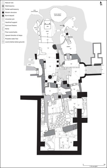
The work of the Nazareth Archaeological Project at the convent began by collating, copying, and re-analysing all extant records of previous investigations of the site.Footnote 18 Though the published record was slight, a considerable body of records had been carefully stored in the convent, including many drawings (often giving measurements) – and even a few photographs showing the discoveries before later alterations took place – alongside extensive written accounts of what was found. All the existing finds were photographed and recorded and drawings were made of those which could be assigned to a find spot through information on the preserved labels. All the archaeological features visible in the cellar were re-surveyed (elevations drawn at 1:10 and plans at 1:20 scale) and Mitchell Pollington completed a detailed Total Station survey at 1:100 of the entire cellar (fig 2). This work produced the new evidence that enabled this reinterpretation of the Early Roman-period use of the site.
Plan of the overall state of the archaeological features in the cellar at the Sisters of Nazareth convent in 2009, prior to the restoration of the floor in Structure 1. Modern walls, including those of the cellar, are in black. Tomb 1 is shown only in dashed outline as it underlies the undisturbed natural rock below Structure 1, but Tomb 2 is marked by the two loculi labelled ‘tomb’ on the top left of the image. Crusader-period wall ‘M4’ is shown in medium grey to the south of the cellar, running from east to west above the break of slope. Immediately to its north is a rectilinear area of Crusader-period paving. Plan: based on a total station survey made for the Nazareth Archaeological Project by Mitchell Pollington, 2008–9.

The natural topography of the convent site
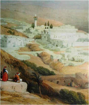
It is perhaps most helpful to begin with a reconsideration of the natural topography of the site. As a watercolour of Nazareth (1838) by David Roberts illustrates (fig 3), until its nineteenth-century infilling, there was a steep-sided wadi approximately along the line of the present Casa Nova Street (the street that runs immediately in front, west, of the current Church of the Annunciation). Traced by Bagatti, the wadi ran northwards following the ‘metalled road which runs to the Fountain of the Virgin’: the road north west of the Church of the Annunciation leading eventually to St Mary's Well.Footnote 19 The natural surface of the limestone in the convent cellar slopes to the east toward this wadi and more sharply to the south. The preserved part of the site was, therefore, at the southern end of a natural limestone ridge parallel to, and above, the wadi, with sharply rising ground to the north and west. This would place the top of the ridge at the north end of the cellar, underneath what is today the convent garden.
Watercolour of Nazareth in 1838, from the south west, by David Roberts. The El Abayad mosque (with minaret) and wadi, then crossed by a bridge, are clearly visible, as is the 1730 Church of the Annunciation (the triple-fronted building with adjacent courtyard) on the left of the picture. Photograph: author, from a print in the museum of the Sisters of Nazareth convent

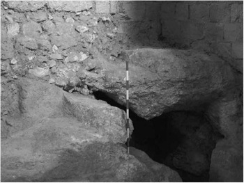
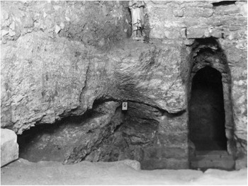
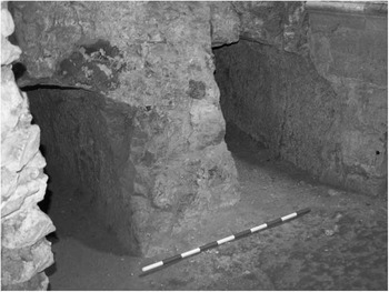
As is common in the Lower Galilee, the rock slope contained natural caves, traces of which remain. One cave has been utilized to form part of a structure (‘Structure 1’), and is discussed below; there is another (fig 4) immediately east of an Early Roman-period tomb (‘Tomb 1’) in the south slope of the limestone ridge. There was also a spring rising underneath the south-east range of the convent cloister, where it was afforded a Crusader-period wellhead and accessed by a purpose-built Crusader-period tunnel, well constructed in ashlar. It is possible, although unproven, that this spring could have risen elsewhere on the site, as the large artificial cave (a Byzantine cave-church) forming the north end of the cellar is exceptionally humid.Footnote 20
The cave east of Tomb 1, on right of picture, from the south west. The scale is 1m high in 10cm divisions. Photograph: author

Two more springs in central Nazareth had been identified before 2006: the ‘Apostles Fountain’, some 200m uphill to the north west of the convent, and an anonymous well in the western part of the ‘old city’ of Nazareth, seen by Paul Range during World War I.Footnote 21 Another, at the so-called ‘Synagogue Church’, north east of the site, is implied by a Byzantine-period water-channel shown on an unpublished plan of c 1900 in the convent archive. This part of the present city had a plentiful local water supply, and Schumacher heard a story of another spring to the south of the convent.Footnote 22 St Mary's Well is the only known spring to the east of the wadi.Footnote 23
Phase 1: Early Roman-period structure(s)
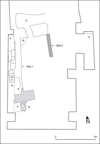
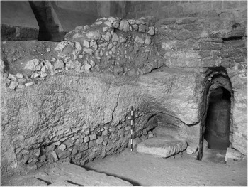
The earliest constructed feature on the site that may be securely dated is a rectilinear structure (Structure 1), located in the centre of the south part of the cellar (fig 5). The largest surviving part of this structure is its freestanding rock-cut wall, the faces of which are smoothed with distinctive vertical tooling, only found on Phase 1 and Phase 2 features at the site (fig 6). This wall (Wall 1) has an arch-shaped rock overhang at its north-west end (figs 5 and 6), derived from the cave from which it was shaped. The upper and lower parts of this overhang are artificially smoothed, the top, which has been cut to be almost flat with its sides cut vertically, more roughly than the (very smooth) bottom.
Phase 1 and possible Phase 1 features, showing the outline of the inner wall of the south of the cellar for orientation. Walls 1 and 2 are labelled on the drawing, with Wall 2 shown in the darkest grey tone. The area within Walls 1 and 2 is the main room of Structure 1. The lightest grey indicates the flights of (probably Phase 1) rock-cut steps (D) underneath one of the Crusader-period stairways. The medium-grey tone indicates Crusader-period walling over, and largely obscuring, Phase 1 rock-cut walling. The features visible immediately north of this, west of Wall 1 and south of ‘A’, are the remnants of cave roof used to support the rock-cut stairs. Key: A = Phase 1 rock-cut wall extending to the west of Wall 1 but continuous with it; B = rock overhang retained to support the roof over the area to the east of Wall 1; C = the ‘Chambre Obscure’, the northern room of Structure 1; D = rock-cut steps; E = continuation of rock-cut Wall 1 at a lower level, due to later destruction of the upper part of the wall on its west; F = southern continuation of Wall 1, continuous with it but truncated to south; G = probable wall tumble from wall indicated by F; H = rock-cut wall, possibly belonging to Phase 1, below later walling. Plan: author

General view of Structure 1 in 2006, from the south. The scale is 1m high in 10cm divisions, and stands on the twentieth-century concrete floor. Photograph: author

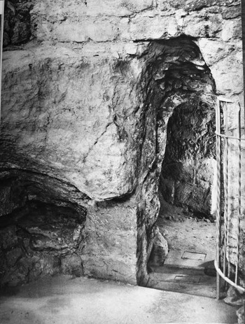
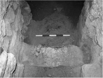
The east and west sides of Wall 1 were cut near-vertical; this left a void near the base where the opening of the cave required masonry blocking (today much restored). The north-east continuation of Wall 1 is cut by a narrow doorway (figs 6 and 7) and the faces of both this extension and the lower part of the doorway opening show similar tooling to Wall 1, suggesting that they reached their present form at the same date. A compacted chalk or chalk-mortar floor (fig 8) was exposed in 2010 during restoration work on the two successive twentieth-century concrete floors within the structure. As this floor passes through the doorway on the lowest level above the natural limestone, it is probably the original floor of the structure. This early floor had been largely cut away by a deep pit (fig 9) filled with hardcore and mid-twentieth-century debris (including a battery, plastic-coated electrical wire and a name-tag bearing the word ‘Canada’) when the concrete floors were laid inside Structure 1 (fig 10).
An anonymous photograph of the rock-cut doorway in Structure 1 in 1953, from the south through the door into the ‘Chambre Obscure’. The twentieth-century concrete floor is clearly visible in the foreground. Photograph: by permission of the Sisters of Nazareth convent

The only remaining part of the original floor of Structure 1, exposed during restoration of the immediately overlying twentieth-century concrete floor in 2010, from the north. The scale is in 10cm divisions. Photograph: author

An anonymous photograph of 1945, showing the pit dug within the floor of Structure 1, from the south. Photograph: by permission of the Sisters of Nazareth convent

Structure 1 with the part of the twentieth-century concrete floors removed in 2010, from the south. The 1945 pit, seen in figure 9, is left partially filled with twentieth-century hardcore, the removal of which was unnecessary for the concrete floor to be restored. The scale is 1m high in 10cm divisions. Photograph: author

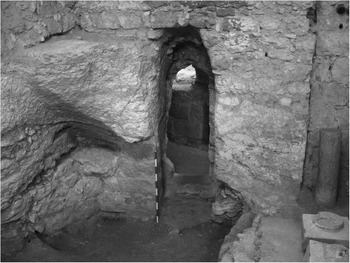
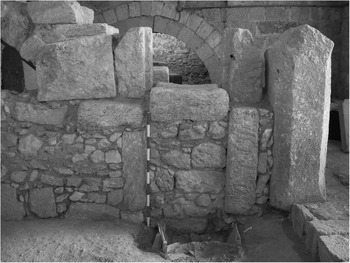
The doorway opens into a smaller room (called the ‘Chambre Obscure’ by the French-speaking nuns), cut into the natural rock. The walls of this room also show the vertical tooling seen on Wall 1. The south-east rock-cut wall of this room terminates approximately where a built wall (fig 11) runs north–south, forming the eastern side of Structure 1. The date of this built wall (Wall 2), which will be discussed further below, is problematical.
Built wall (Wall 2) on the east of Structure 1, from the west. The scale is 1m high in 10cm divisions. Photograph: author

The existence of all of the rock-cut walls, and a narrow rock-cut stairway leading to the wall-top of Wall 1, cut into the rock along the south-west side of that wall, was known prior to 2006. However, further rock-cut walls were identified by the Project beneath Crusader-period features in the cellar. A short stretch of east–west rock-cut wall runs across the south of Structure 1, below the substantial east–west Crusader-period wall called by earlier investigators ‘M4’. This may have stretched as far as the line of Wall 2, as is suggested by a cut into the natural limestone parallel with the south of the Crusader-period paving immediately to its north, but this cut might have been made merely to accommodate that paving. Its original east–west length cannot, therefore, be determined definitively from visible evidence, but it certainly ran as far as is shown by its outline in medium grey tone on figure 5. At the north terminal of Wall 1, another similar rock-cut wall (A on fig 5) projects to the west, preserved beneath modern convent walling. This appears to continue west out of the present cellar.
Other ‘new’ features that probably belong to this phase are a low stretch of rock-cut wall continuing the line of Wall 1 to the south (F on fig 5; fig 12), showing that the south end of the structure has been cut by the forecourt of Tomb 1. A pile of light grey limestone rubble, with a heavily eroded surface (probably tumble from the wall), lay slightly downslope to the east (G on fig 5). A shorter stretch of rock-cut wall below a Crusader-period wall (H on fig 5), to the east of the small rectilinear space called the ‘Chambre Obscure’, is aligned with the south wall of that room, possibly suggesting either its continuation to the east or another nearby structure.
The area south west of Structure 1 from the east, showing the truncated rock-cut wall, just above scale, and the wall tumble, adjacent to its east, just below the scale, which is in 10cm divisions. Photograph: author

There is also a series of enigmatic rock-cut features immediately south of the Crusader-period wall ‘M4’, some of which are truncated by the courtyard of Tomb 1. They include a rectilinear rock-cut area with an approximately flat base and raised linear rock-cut edge to its east, somewhat resembling an eroded low rock-cut wall. These have been omitted from figure 5 as their date is uncertain even in relative terms, except in so far as they may pre-date Phase 2.
A purely structural interpretation of the Phase 1 features, unconcerned for the moment with their date or function, is that they consisted of a rectilinear room built by cutting back a (probably low-roofed) natural cave at the base of an east-facing break-of-slope to form Wall 1, and another smaller room to its north, made by cutting into the south-facing rock-face of the hillside. The smaller room was entered from the south by a doorway, similarly rock-cut. There were other walled spaces to the west and, perhaps, to the east of these rooms, indicated by less well-preserved fragments of similar wall. The continuation of Wall 1 beyond the south wall of the principal rectilinear room suggests a further walled space on this side, and wall tumble may indicate that it supported a stone-built wall. Although so little survives of this part of the structure that one is unable to determine its plan, evidence for the use of stone walling may be used to reconstruct the eastern walls of the rooms as stone-built.
Wall 1 was well made and its sides and top smoothed. This employed rock-cutting technology resembling that used locally in the Roman period.Footnote 24 A stairway on the west side of the room gave access to a roof or upper storey, which was presumably of timber as no roofing tile was found anywhere on the convent site and the cave roof had been cut back.Footnote 25 This level was partly supported by the retained rock overhang in the north-west corner of Wall 1, the top of which was flattened for this purpose, showing skill in using the local stone. Knowledge of the characteristics of the local rock and how to work it is further evidenced in the retention of the arching upper part of the cave to support the rock-cut stairway (fig 13).
The arched upper part of the cave cut back to form the west of Wall 1, from the north. The scale is 1m high in 10cm divisions. Photograph: author

These structural observations would give a principal rectilinear room c 10m long ×c 4–5m, with a small northern room c 2m × c 4–5m, against a hill-slope rising to the north. Other walled spaces existed to the south, west and (probably) to the east. The width of the principal room would imply that there may have been internal supports, as timbers of more than c 3m long might be considered unlikely, even in the relatively well-wooded Nazareth area.Footnote 26 If so, no evidence for these seems to have been recorded by earlier investigators, but this (along with the absence of any other internal features) is hardly surprising, considering that they ‘excavated’ this area with pick-and-shovel in semi-darkness and dug through the identifiable floor of the structure.
A rock-cut vertical shaft immediately south east of the projected eastern wall-line of Structure 1 was used in the Crusader period as a squint looking vertically onto an altar then located in a small chapel adjacent to Tomb 1, but the uppermost 46cm shows similar tool marks to those on Structure 1 and Tomb 1. Such a feature would have no parallel in known tombs of the type to which Tomb 1 is assigned below, but is adjacent to the postulated eastern wall of Structure 1 in a typical position for cisterns collecting run-off from roofs in domestic contexts in the Roman-period Galilee.Footnote 27 Although a Crusader-period date for the whole feature is more likely (and it is insufficiently well dated for inclusion in figure 5), a Phase 1 date for the top of this feature could be just possible.
Dating Structure 1
Structure 1 may be dated stratigraphically to the Early Roman period, specifically to the first century ad. The deep rectilinear forecourt of Tomb 1 (fig 14) cuts away the south of Structure 1. Given that Tomb 1 is a kokhim tomb, typologically dating to the first century ad (see below), then Structure 1 must date from the first century ad or earlier. This gives a broad terminus ante quem for the structure, and, although a terminus post quem is, of course, impossible for rock-cut walls, finds within Structure 1 strongly support a date in the Early Roman period and, given this terminus ante quem, the first century ad. A freshly broken body sherd of Early Roman-period cooking pottery was found on the original floor surface just south of the doorway of Structure 1. Another was on the surface of what seems to be the original cave floor on the south-west edge of the twentieth-century cut.
Tomb 1 from the south, showing the entrance and the ‘rolling stone’. The scale is 1m high in 10cm divisions. Photograph: author

The only other stratified artefacts from inside Structure 1 come from Senès’s excavation in this part of the site, prior to the destruction of its original floor. In an unpublished description, Senès reports that he found an uppermost layer composed of mixed soil and fragments of white rock (that is, the natural limestone, probably a product of structural decay after abandonment), above ash mixed with soil and charcoal fragments, perhaps relating to a phase of burning found in many areas of the site and that probably ended its Crusader phase (Phase 4). This burning layer contained Roman-style glass, Byzantine mosaic cubes, pottery, a small blue cube (presumably from a fine mosaic), bones, burnt stone, a burnt jar and white mortar.
Probably because he believed them to have religious significance, Senès placed the soil and finds from the remaining layer beneath this in a sturdy box. The box appears to have contained the soil layer immediately above the limestone floor of the structure. This box, with Senès’s label still intact, was kept (apparently unopened) in the convent museum, where we had an opportunity to examine its contents in detail in 2006 and later. The soil is light yellow-brown silty sand, with few pieces of charcoal. Within it are small Early Roman-period Kefar Hananya-type pottery sherds,Footnote 28 two fragments of what may be light greyish-white limestone vessels – also probably dating from the Early Roman periodFootnote 29 – decayed yellowish-white wall plaster, a pierced stone spindle whorl and small shards of ‘Roman-style’ thin-walled green glass vessel. The small size of the cooking-pot sherds and glass shards (including examples under 0.5cm) might suggest that they were from vessels broken at, or near, the location in which they were found.
The lowest stratified deposits within Structure 1 are, therefore, associated with pottery that was produced only in the Roman period and include no material later than the Early Roman period. While it is, theoretically, possible that the structure itself could be earlier in date than the earliest finds above its floor, this suggests that at least the main rooms of Structure 1 were built and disused during the first century ad.
At this point we may return to the question of dating Wall 2. Although it was certainly rebuilt in the Crusader period (incorporating ashlar with distinctive twelfth-century diagonal tooling), much of the stone used in its construction shows no such diagnostically ‘late’ evidence. It may be a wholly Crusader-period feature, or perhaps it utilized an earlier stone-built wall for its foundation or even incorporated it in its construction. If this seems unlikely, one should note that exactly this type of reuse was observed at the nearby excavated site at the International Marian Centre site (see below), where Mamluk walls sit on those dating to the Early Roman period.
Moreover, the excavated first-century ad settlement site at Yodefat has a house wall (seen by the author in 2009) closely resembling this feature, especially in the use of two vertical pillars in a mortared rubble wall. If this is more than coincidence, then either Wall 2 is Crusader in date but a deliberate copy of a much earlier wall visible before it was constructed, or it indeed incorporated walling belonging to Structure 1. Even if one accepts merely that Wall 2 merely follows the line of a no longer extant Phase 1 built wall, then this indicates the eastern wall of Structure 1.
Together, this evidence allows us to reconstruct Structure 1 in some detail, identify what is probably an associated assemblage of artefacts, and date the structure to the first century ad. These attributes provide a basis for proposing a data-based interpretation for Structure 1 using conventional archaeological logic.
Interpreting Structure 1
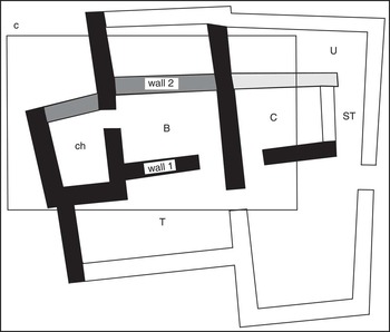
Structure 1 finds many analogies among known Early Roman-period domestic structures from the Galilee.Footnote 30 For example, the plan of the main room and its annexes may be paralleled in the western part of the first-century ad settlement at Capernaum.Footnote 31 The hill-slope location resembles the Roman-period houses at Khirbet Kana and Yodefat,Footnote 32 and the flight of steps to an upper floor is paralleled in the Galilee at several Early Roman-period domestic sites.Footnote 33 Indeed, the similarities are striking if one maps the plan onto the model ‘courtyard house’ as first set out by HirschfeldFootnote 34 and accepted by the Nazareth Village Farm project (fig 15). Although Hirschfeld himself supposed ‘courtyard houses’ to be an urban phenomenon, Galor has shown that this is not the case in the Galilee.Footnote 35
The Phase 1 evidence from the Sisters of Nazareth convent compared to the model ‘courtyard house’, as proposed by other scholars. The outline of the cellar is mapped as a box indicated by ‘c’; walls certainly partially or wholly present at the Sisters of Nazareth site are shown in black; those which may be reasonably inferred or for which less certain evidence exists are shown in medium grey; that which would have been destroyed by the construction of Tomb 1's forecourt is in lighter grey. Walls 1 and 2 are marked to orientate the model house. Key: features at the Sisters of Nazareth site are in lower case; those of the model house in upper case; B = bedroom in the model house; ch = ‘Chambre Obscure’/storeroom in the model house; U = upper storey room; ST = stairway; T = traklin (family living room) in model house; C = courtyard with cistern in the model house. Plan: author

Locating the model house relative to the cellar, one finds that, of eleven walls, there is direct evidence for eight walls wholly or partially at the Sisters of Nazareth site, with two more being the stone-built eastern walls postulated on site-specific grounds above. The remaining wall is in a position where it would have been cut away by the construction of the forecourt of Tomb 1 (see below). However, although the plan fits extremely well, the stairway west of Wall 1 suggests a courtyard area to its west, while this was the traklin (family living room) in the model house. This need only imply that the use of space was shaped in detail by the topography of the site, although it warns against inferring room-function uncritically from the model.
The one unusual characteristic of Structure 1 is that it is partly rock-cut. However, rock-cut components were commonly employed in domestic structures of Early Roman-period date in the Galilee, and their extensive use in this structure is simply explained by its location against a steep hill-slope consisting of rock that is easily worked using techniques which excavated sites show were employed at this time in the area, yet durable enough to use for house walls.
While few other artefacts (and no organic material other than charcoal) can be confidently assigned to this phase, it is noteworthy that a stone spindle whorl is among the objects in the earliest soil layer. In addition to the Early Roman-period Kefar Hananya-type cooking-pot body-sherds, this may support a domestic interpretation.Footnote 36 Such an interpretation is further supported by the existence of partly rock-cut structures in use locally until the late twentieth century. Indeed, one recently disused example is just a few streets away from the convent site on the hill to its west. There is, of course, no need to postulate continued occupation of these structures from the Roman period, or even continuity of building traditions, to recognize that climate, topography and the physical possibilities of working limestone with basic iron tools might have led to a similar architectural style in this locality.
One can, then, parallel the location, plan and artefactual assemblage of Structure 1 with other excavated Early Roman-period domestic buildings from the Galilee. There is a specific structural analogy between Structure 1 and the classic ‘courtyard house’ of the same period, and nearby ethnographic parallels for the same sort of domestic structure being used in recent centuries. Nevertheless, the legacy of earlier investigations and speculation about the site is likely to render a domestic interpretation of Structure 1 contentious to some. Specifically, the subsequent use of the site, in Phase 2, as a Jewish cemetery might be thought to cast doubt on this interpretation, as Second Temple Judaism required the separation of domestic and funerary activities.
Other than being partly rock-cut, Structure 1 has almost no resemblance to either kokhim tombs of Second Temple date or to the large underground halls and acrosolia of later Roman-period Jewish catacombs, as at Beth She'arim.Footnote 37 However, following Bagatti, scholars have assumed that all the pre-Crusader features at the site are funerary in nature. Five arguments might be held to support such a view:
-
1. the physical separation by the wadi of the Sisters of Nazareth site from the Roman-period domestic occupation evidenced at the Church of the Annunciation suggests a division into occupation and burial zones, marked by the valley of the wadi;
-
2. the superimposition of Jewish tombs on a disused Jewish domestic structure is unusual and might be thought to contradict the Jewish religious law that forbids occupation on a burial site;
-
3. the proximity of other Roman-period Jewish burials reinforces the view that this could not be domestic as it contradicts the requirement in Jewish religious law for tombs to be located well away from human occupation;
-
4. the courtyard surface covering the south of the area within the Phase 1 Structure 1 resembles those found in Roman-period funerary contexts; this could be a courtyard surface associated with a destroyed tomb or one that has yet to be discovered;
-
5. there is no mikveh for ritual purification; one would be expected if this was a domestic structure rather than a tomb.
At first sight these seem like convincing arguments against interpreting Phase 1 as representing domestic occupation rather than funerary activity. However, all can be conclusively countered.
-
1. The wadi did not divide Early Roman-period burial from archaeologically attested Early Roman-period settlement. There are published records of Early Roman-period tombs east of the wadi, not least a kokhim tomb, its door blocked with a rolling stone, only c 30m south of the Church of the Annunciation (for its approximate location, see C on fig 1).Footnote 38
-
2. Although Jewish law is categorical that one is prohibited from living at a cemetery site, there is no evidence that Second Temple-period Jewish law forbade burial on a disused occupation site.Footnote 39 The Second Temple-period text that gets closest to understanding domestic occupation as impure is the Temple Scroll,Footnote 40 which discusses the impurity of occupied dwellings and how they can be made clean. Obviously, an objection based on that source would be ruled out by the possibility that the structure could have been cleansed prior to burial or was disused prior to the start of burial at the site.
-
3. The total distance between the Early Roman tombs in Nazareth is at most 400m.Footnote 41 The tombs encircling Roman-period Nazareth could, therefore, never have been as far from the contemporary settlement as at, for example, Jerusalem or Khirbet Kana,Footnote 42 nor even in conventional reconstructions of the occupied area in Nazareth could they have conformed to Rabbinic statements on the distance between occupied areas and tombs.
-
4. The use of freestanding rock-cut walls for a cemetery courtyard (or for that matter, a mausoleum) would be unique in the Galilee.Footnote 43 It might be argued that funerary courtyards are sometimes cut into hill-slopes (as at Beth She'arim) and open on one side, but the rock-cut stairway and retained overhang suggest access to a roof area or upper storey, rather than an open courtyard. No possible kokhim or acrosolia have been found within or adjacent to Structure 1, and Second Temple-period Jewish rock-cut tombs had rock roofs, whereas this structure probably had a timber roof.Footnote 44 It is, therefore, unlikely that Structure 1 was, or led to, a Jewish tomb of any of the well-attested Early Roman-period types, and the removal of the cave to its west to form Structure 1 precludes its use for burial.
-
5. First-century ad Jewish domestic structures at some sites in the Galilee, for example, at Capernaum and Bethsaida, lack ritual baths.Footnote 45 Social, economic or topographical contexts could explain why some domestic buildings of this period are without these.
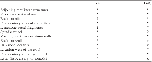
In 2009, the domestic interpretation of Structure 1 received some unexpected archaeological support.Footnote 46 During September–December 2009, the Israel Antiquities Authority (IAA) undertook a rescue excavation (directed by Yardenna Alexandre) ahead of, and during, construction work at the International Marian Center of Nazareth (IMC: for its approximate location, see D on fig 1). No published report on this excavation is available at the time of writing, but according to the website of the Israeli Antiquities Authority,Footnote 47 the excavation found roughly built stone walls belonging to a first-century ad structure with at least two rooms and probably a courtyard. In the latter were a rock-cut silo and what may be a rock-cut refuge tunnel. This structure was associated with sherds of Early Roman-period pottery and ‘several fragments of chalk vessels’. Mamluk-period walls employed those of the Roman period as foundations. This is obviously very similar to the evidence, first published in the project interim report in 2007 and discussed above,Footnote 48 from Phase 1 at the Sisters of Nazareth site, as table 1 shows.
A comparison between the finds at the Sisters of Nazareth site (SN) and the International Marian Center site (IMC)

* = present; x = absent; ? = not known whether present or absent at time of publication
Consequently, four of eight attributes known at the IMC can be paralleled at the convent site. This would be five of eight, if one allows that the probable ‘wall tumble’ recorded by us, or Wall 2 in its original form, may be the traces of Phase 1 stone walls similar to those found at the IMC; and six of eight, if what could be fragments of limestone vessels have been correctly identified at the convent site, although the latter is uncertain. The most striking dissimilarities between the IMC and the Sisters of Nazareth sites are the presence of rock-cut freestanding walls, easily explicable due to the hill-slope location as discussed above, and refuge tunnels, which might be absent on chronological grounds alone.
The IMC excavation helps to refute three possible objections to a domestic interpretation of Structure 1 at the Sisters of Nazareth site. First, the IMC site is on the west of the filled-in wadi, so that occupation existed on both sides of the wadi rather than only to its east. Second, judging from data currently available, the structure at the IMC was apparently in use contemporary with Tomb 1 at the Sisters of Nazareth site, showing just how closely burial and settlement might be juxtaposed. Third, the IMC structure lacks a mikveh.
Conclusion to the discussion of Structure 1
Structure 1 was, therefore, probably a first-century ad domestic building, perhaps a ‘courtyard house’, located on a broad terrace cut into the hill-slope of a small hill or ridge along the western side of the former wadi. The local topography allowed its builders to use more rock-cut components for the house than usual, but where this was impossible stone-built walls were employed. Fragments of wall plaster and portable artefacts found inside the structure suggest that the walls of the house were plastered and that it had culturally Jewish occupants, including (given the gender association of weaving in Second Temple Judaism) at least one woman.Footnote 49 This is exactly what might be expected of an Early Roman-period Jewish family home from settlement sites excavated in the Lower Galilee and elsewhere in Israel.Footnote 50
Broadly contemporary occupation was present to the north east of the site, at the IMC, and to its south east, at the Church of the Annunciation site. Presumably the water supply provided by the springs at the Sisters of Nazareth site and ‘Apostles Fountain’ (and perhaps others) attracted settlement to this area, despite the sloping topography. The finds from all these sites suggest a culturally Jewish community obeying the Jewish purity laws as they were understood in this period, just as our earlier work in the countryside would lead one to expect.
Phase 2: Early Roman-period burials
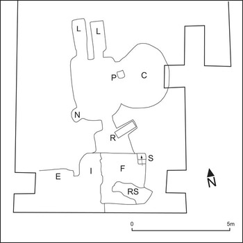
This phase is evidenced by two rock-cut kokhim tombs: Tomb 1 (fig 16) and Tomb 2, at the southern end of the large cave encompassing most of the north of the cellar. Tomb 1 is a well-preserved example of a kokhim tomb with a rolling stone (33cm thick × 109cm in diameter) in a rock-cut track, probably a Hachlili ‘(Jerusalem) Type I tomb’.Footnote 51 Two loculi (L on fig 16) are preserved on the north side, while a surviving pillar of rock (P on fig 16) attests to another two (at least) on the eastern side, although the actual loculi have been cut away by the construction of a later Christian chapel (C on fig 16). Traces of what may be previously unnoticed and very faint Hebrew (or Aramaic?) inscriptions can be seen in the same relative positions adjacent to each of the loculi in Tomb 1. As the tomb was sealed at the end of the Crusader period, and inscriptions of this type are unlikely to have been added in a Byzantine or Crusader-period ecclesiastical context when it was open, these inscriptions probably date either from Phase 2 or, hypothetically but very unlikely, from after it was excavated in the late nineteenth century. Assuming them to date from Phase 2, they may preserve the names of those originally buried in the loculi of Tomb 1. There is a small niche in the south-west corner of the main chamber (N on fig 16), possibly for use in ossilegium. A circular closure stone (R on fig 16), with a T-shaped slot to accommodate it, is still preserved at its entrance to the south, where a forecourt, served by a series of rock-cut steps in its north-east corner, opens to its south. Again, the tomb was cut into the face of the hillside, which in this case was to the south. Topography perhaps explains the extension of the forecourt to the west (E on fig 16), although later infilling (I on fig 16) renders examination of this area impossible without renewed excavation.
Plan of Tomb 1, showing the outline of the inner wall of the south of the cellar for orientation. L = surviving loculi; N = niche; P = stone pillar indicating the division between two destroyed loculi; C = later chapel; R = rolling stone (shown in rock-cut slot); S = steps into forecourt; F = forecourt; RS = rock slope into forecourt; I = later infilling of the tomb forecourt retained by a built wall to its east; E = cut into rock indicating extension of forecourt to west or another tomb forecourt. The west end of this is shown to end before the edge of the cellar because it is overlaid by soil to the west of this. Drawing: author, based on Bagatti Reference Bagatti1937

While dating Type I tombs in Jerusalem to the Hasmonean period, Hachlili has argued that they may be later in the Galilee,Footnote 52 especially as ossuary burial – with which they are often associated, and which could be evidenced by the small niche – probably began in the Galilee only after c ad 70. Aviam, Berlin and others have dated similar tombs in the Galilee to the first century ad, and Aviam has suggested that they may have been introduced from the south by Late Hellenistic farmers.Footnote 53 Hachlili's dating of the use of loculi to after the first century bc,Footnote 54 and the use of a rolling stone to seal a burial of this type to no later than the end of the first century ad,Footnote 55 argue that Tomb 1 may be dated typologically to the first century ad. Kloner and Zissu agree that tombs sealed by rolling stones in rock-cut tracks, especially if, as here, the ‘round stone’ has a diameter of over 80cm, can be dated to the first century ad but they add that they see these are especially popular ‘in the middle of the century’.Footnote 56
Tomb 2 is much less well preserved than Tomb 1 and has to be reconstructed from several fragments of evidence. The north of the cellar is dominated by what appears to be a single large cave, at most c 8m high and c 16 × c 3–7m (the width and height of the cave walls vary considerably along its length), immediately to the north of the Phase 1 rock-cut structure. Upon careful examination, the walls of this ‘Large Cave’ were seen to consist of two separate spaces (that is, effectively, two caves), an apsidal-ended cave created by cutting back from the, now largely destroyed, north wall of an original – perhaps even partly natural – south cave. The south of the Large Cave was apparently always entered, as today, from the east, given that the natural rock rises to above head height on the south and west of the cave.
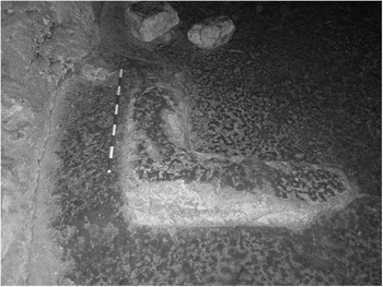
Two loculi (one of which is said to have contained a complete skeleton) were cut into its western wall (fig 17).Footnote 57 An L-shaped rock-cut feature in the centre of the north side of the Large Cave was found to contain a crouched skeleton (reburied in the nineteenth century), with a copper-alloy ring from which the intaglio was missing (fig 18). Although assumed to be later in date by previous investigators, there is no reason why this has to be post-Roman.
Tomb 2, the remaining loculi in the south-west wall of the Large Cave, from the south east. The scale is 1m long in 10cm divisions. Photograph: author

Tomb 2, rock-cut ‘L-shaped’ feature on the floor of the Large Cave, from the south. The scale (parallel with the north wall of the cave) is 1m long in 10cm divisions. Photograph: author

The plan reproduced by Soeur Marie shows another two loculi cut into the west wall of the same narrow passage,Footnote 58 apparently confirming that the south cave was a tomb. Regrettably, this part of the site is no longer visible beneath modern walls. Schumacher recorded a north–south rectilinear rock-cut feature in the centre of the floor of the chamber to which the narrow passage led.Footnote 59 The rectilinear feature that Schumacher saw might also have been a grave, but as no bones were recorded from the feature (and this feature is no longer visible), this cannot be confirmed. Immediately east of the cut feature noted by Schumacher, Senès recorded two other burials, both north–south, shown only on an unpublished plan of the site. This gives a row of four rock-cut tombs along the south of the south cave; two of these were filled with pebbles and contained coins with ‘Jewish’ (presumably Hebrew) letters on them.
These features are best interpreted as the remaining traces of a rectilinear kokhim tomb, termed here ‘Tomb 2’, the northern side of which was destroyed by the construction of the apsidal-ended cave. If symmetrical, this would have had three loculi on each of the west, north and south sides, with an entrance on its east. It could be that the rectilinear space later encapsulated in Crusader-period masonry to its east was first formed by the construction of its forecourt. In any case, it must have been constructed by working inward from the east slope of the hillside.
Phase 2, therefore, comprises two Roman-period kokhim tombs, probably family burial places. These plainly represent part of the extensive cemetery of such tombs known since the nineteenth century to encircle the centre of modern Nazareth, presumably located to be around what (when each tomb was established) was then the perimeter of Roman-period Nazareth.Footnote 60 However, it must be remembered that the relationship between occupation areas and burial zones might have been more fluid than often imagined. There is possible evidence for the abandonment of settlement areas at the Church of the Annunciation site, at the IMC site and, probably later, at ‘St Mary's Well’, as well as at the Sisters of Nazareth site.Footnote 61 Thus, the settlement may have shrunk in size during the Early Roman period and, to judge from the Sisters of Nazareth site, burial encroached on its periphery.
The two tombs at the Sisters of Nazareth site closely resemble those found elsewhere in Nazareth and in neighbouring Reina and Migdal Ha'Emeq.Footnote 62 The rarity of such tombs closed by rolling stones, observed by Kloner and Zissu, alongside the absence of similar tombs from Sepphoris and Khirbet Kana, may suggest a localized cultural practice in the Early Roman period, presumably relating to the more strictly religious Jewish identity of the zone focused on Nazareth identified in the landscape survey.Footnote 63
Conclusion
The Sisters of Nazareth site has a very well-preserved first-century ad domestic structure, perhaps a ‘courtyard house’. This was conventional in plan, but the location allowed its builders to work the limestone hillside into more solid walls than they could possibly construct themselves. This ability to work stone in a sophisticated way may reflect the otherwise archaeologically attested familiarity of local people with quarrying. Finds indicate low-status (but far from impoverished) culturally Jewish occupants, probably including at least one woman. This is all consistent with what one might expect on the basis of other settlements of this period, and with what was found at the International Marian Center nearby.
While it is unlikely that further excavation will take place at the convent, past work provides plentiful evidence to demonstrate the importance of the Sisters of Nazareth site. Further analysis of the data from the twenty-first-century work at the site may be expected to provide much more information about Early Roman-period Nazareth in future.
Acknowledgements
Our work at the Sisters of Nazareth convent was only possible through the kind permission and help of the Israel Antiquities Authority and the Sisters of Nazareth. The convent was an exemplary host for an archaeological project, and I would especially like to thank Sisters Stefania Cantore (the convent superior), Margherita Giaccone (the convent superior when our work there began) and Claude Cherier (the oldest of the Sisters, who could recall earlier work). The assistance provided by Eliya Ribak before the survey was invaluable, as was that provided on site by her, along with Mitchell Pollington, Ifan Edwards, Helen Robertson, Mike Burns, Maria Calderon, Alice Larter, Mark Laynesmith, Nicola Mellor, Bernard Mulholland and Simon and Jemma Underdown. Thanks are also due to Petra Dark, James Crossley, Tony Grey, Martin Henig, Birgitta Hoffman, Alan Millard, Joseph Patrich, Tessa Rajak, Edna Stern, Sacha Stern, Joan Taylor and John Wilkinson for their advice and help. Thanks also to the organizations funding the project, especially the Palestine Exploration Fund and Late Antiquity Research Group, and to Felicity Cobbing, Sam Moorhead and Jonathan Tubb at the Palestine Exploration Fund, for their advice and assistance. Lastly, we would like to thank the people of twenty-first-century Nazareth for continual support and help throughout the project.