Introduction: The Chakhmaq Culture of northeastern Iran
Until a decade ago, the Neolithic of northeast Iran was perceived under the name of the well-known “Jeitun Culture” of southern Turkmenistan. It was because by the time the first Neolithic material started to be unearthed from the 1960s-1970s excavations at three sites of Yarim Tappeh (Crawford Reference Crawford1963), Turang Tappeh (Deshayes Reference Deshayes1967), and Sang-e Chakhmaq (Masuda Reference Masuda and Bagherzadeh1972, Reference Masuda and Bagherzadeh1974) (Figure 1), the Jeitun culture had already established itself as a prominent, well-defined Neolithic culture in the northeastern Iranian Plateau (e.g., Masson Reference Masson1961; Masson and Sarianidi Reference Masson and Sarianidi1971; Mellaart Reference Mellaart1975). The excavators of these sites found the closest parallel for their ceramic assemblages in the Jeitun culture ceramic corpus rather than Zagros in the west (Deshayes Reference Deshayes1967, 123; Masuda Reference Masuda1984, 210; Stronach Reference Stronach and Moorey1972, 22). Other scholars also considered the materials from these sites to be in the sphere of Jeitun culture (Coolidge Reference Coolidge2005; Harris Reference Harris2010; Kohl Reference Kohl1984). In fact, until recently, for addressing the Neolithic material of northeast Iran to the international audience, the usage of “Jeitun Culture”—sometimes in combination with the newly coined “Chakhmaq Culture”—was inevitable (e.g., Garazhian et al. Reference Garazhian, Papoli Yazdi and Fakhr-e Ghaemi2014; Roustaei Reference Roustaei2012, Reference Roustaei2014). The situation has changed since almost a decade ago, thanks to an increasing body of information obtained from the archaeological excavations at a dozen sites in northeast Iran. The new information now allows us to elucidate in further detail the similarities and differences between the Neolithic of northeast Iran and Jeitun culture (e.g., Roustaei Reference Roustaei2014). Therefore, it is more accurate to use the term “Chakhmaq Culture” in addressing the Neolithic of northeast Iran because we think there is now a good deal of information on this culture to be regarded as a well-articulated prehistoric entity.
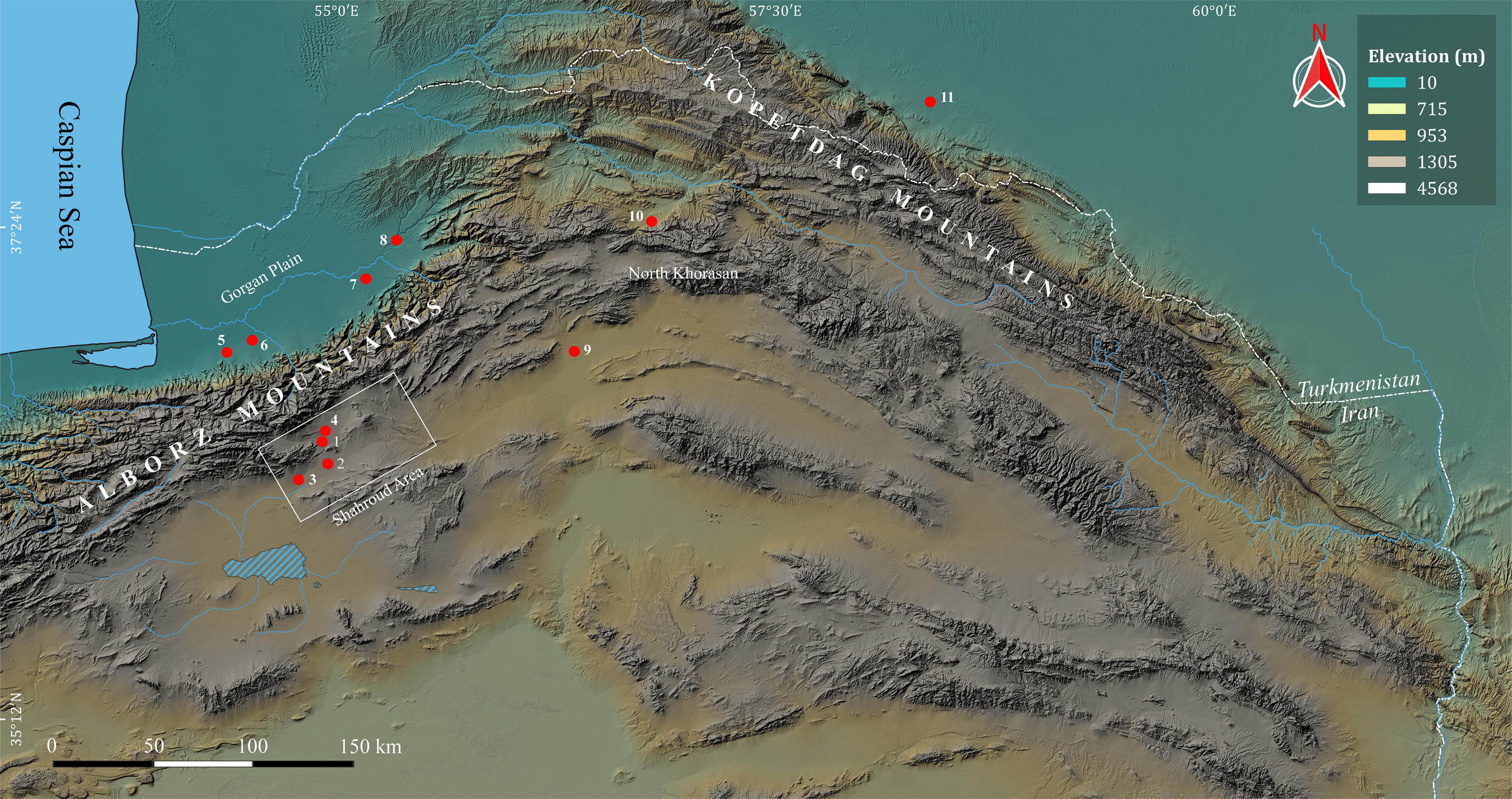
A map of northeastern Iran showing the sites’ locations mentioned in the text. 1. Sang-e Chakhmaq; 2. Rouyan; 3. Kalateh Khan; 4. Deh Kheir; 5. Poukerdoval; 6. Turang Tappeh; 7. Yarim Tappeh; 8. Aq Tappeh; 9. Tappeh Pahlevan; 10. Qaleh Khan; 11. Jeitun (© M. Alirezazadeh).

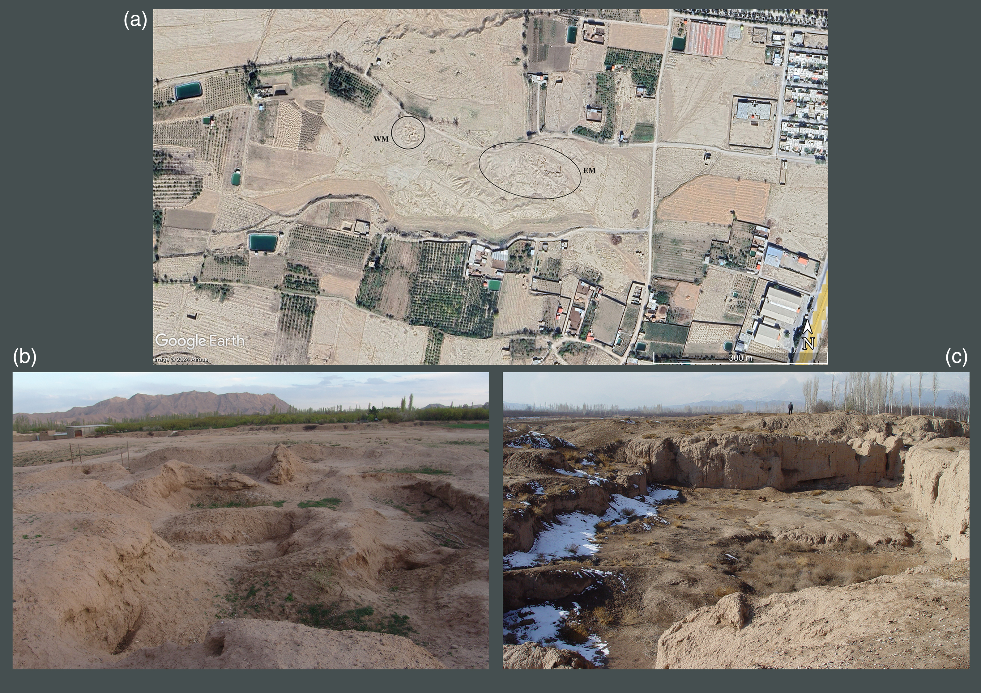
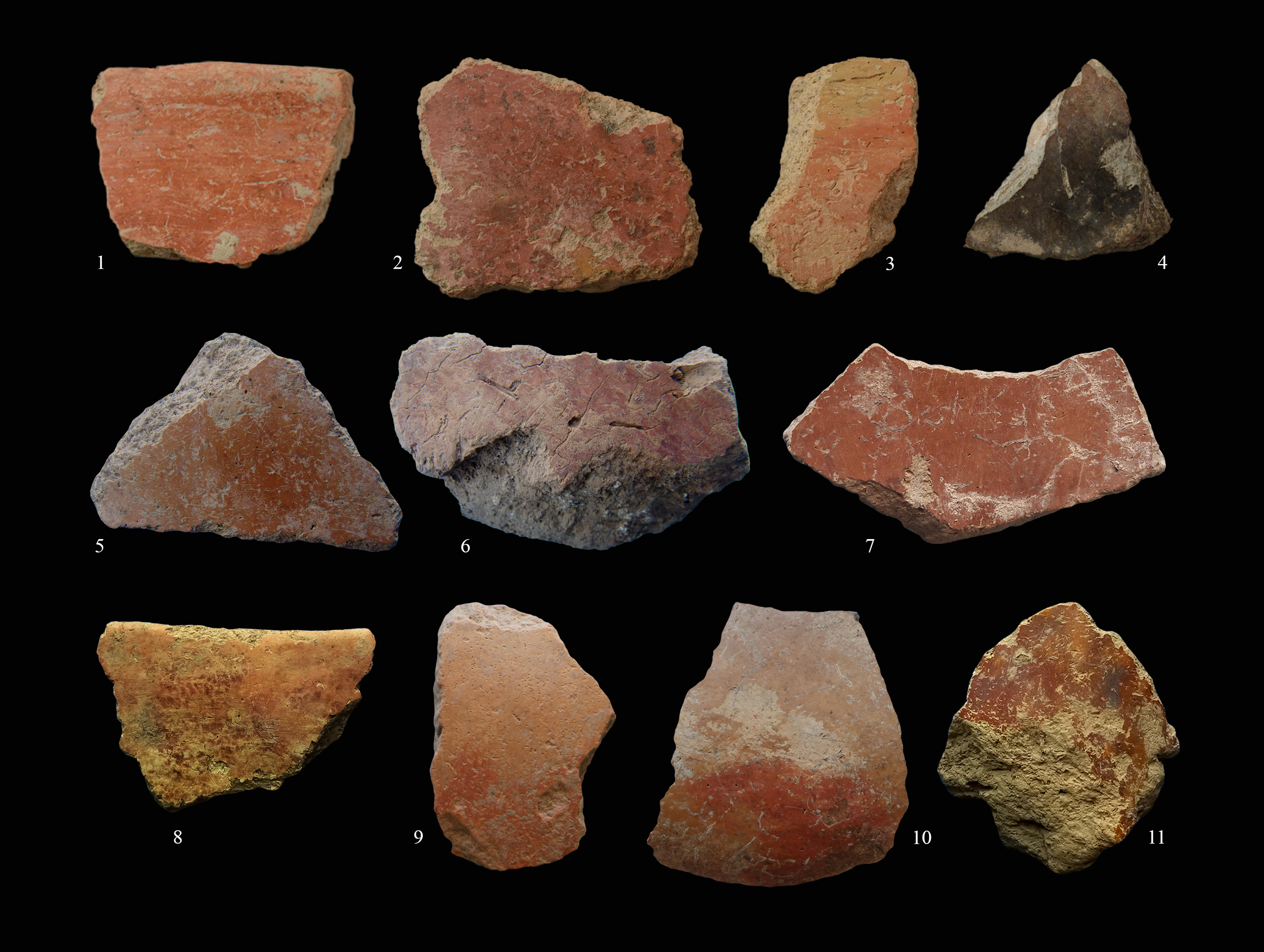
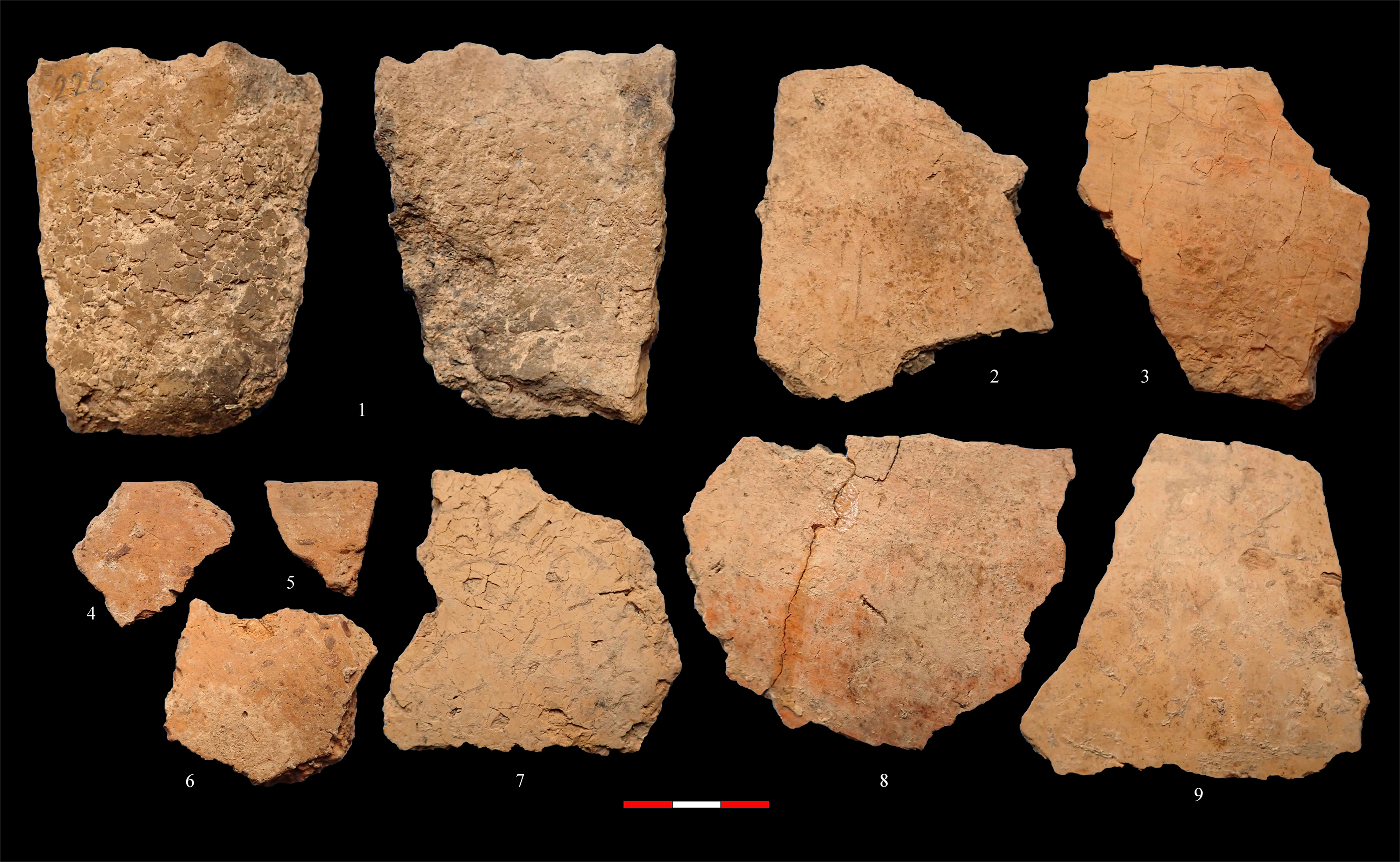
Thanks to a long occupational sequence that encompasses almost two thousand years, from ca. 7100/7000–5300 BCE, the twin mounds of Sang-e Chakhmaq, near Shahroud, stand as the type site of the Neolithic of northeastern Iran (Figure 1) (Coolidge Reference Coolidge2005; Harris Reference Harris2010; Kohl Reference Kohl1984; Roustaei Reference Roustaei2014, Reference Roustaei2016a). The site, consisting of two adjacent mounds 100 m apart, the West Mound (WM) and the East Mound (EM), was excavated extensively by a Japanese team over four seasons in the 1970s and was revisited by the author in 2009 (Figure 2) (Masuda Reference Masuda and Bagherzadeh1972, Reference Masuda and Bagherzadeh1974, Reference Masuda1984; Masuda et al. Reference Masuda, Gotō, Iwasaki, Kamuro, Furusato, Ikeda, Tagaya, Minami, Tsuneki, Matthews and Fazeli Nashli2013; Roustaei et al. Reference Roustaei, Mashkour and Tengberg2015). The WM represents a small hamlet, less than 0.4 ha in area, occupied during the late eighth-early seventh millennium BCE (Nakamura Reference Nakamura and Tsuneki2014; Roustaei et al. Reference Roustaei, Mashkour and Tengberg2015). Based on an almost 480 m2 exposure, the Japanese divided the 3-m-thick sequence of the site into five architectural phases—I–V, top-down—characterized by well-planned, mud brick houses featuring elaborate multiple red painted gypsum floors and large, raised square hearths (Masuda Reference Masuda and Bagherzadeh1974, Reference Masuda1984). According to the bioarchaeological studies, the WM inhabitants’ subsistence economy relied on domesticated plant and animal species, including several species of wheat, barley, and goats, introduced into the region from perhaps the eastern Fertile Crescent (Fuller Reference Fuller and Tsuneki2014; Harris Reference Harris2010; Roustaei et al. Reference Roustaei, Mashkour and Tengberg2015), a notion that gains further support from the obsidian artifacts of east Anatolian sources in the site lithic assemblage (Roustaei and Gratuze Reference Roustaei and Gratuze2020). The discovery of a few ceramic fragments from the upper levels (Figure 3: 1–4) caused the excavator and some researchers to consider the site as a partially aceramic occupation (e.g., Kohl Reference Kohl1984; Masuda Reference Masuda and Bagherzadeh1976; Thornton Reference Thornton, Matthews and Fazeli Nashli2013) (for further discussion, see below).
a. Satellite view of the twin mounds of Sang-e Chakhmaq (© Google Earth); b. Main trench of the Japanese excavation at the WM; c. Main trench of the Japanese excavation at the EM.

A selection of the earliest ceramics of WM and Rouyan. Nos. 1–4: the WM, Japanese excavations (Tsuneki Reference Tsuneki, Tsuneki, Nieuwenhuyse and Campbell2017, Fig. 11.8); 5–6: the WM, the 2009 sounding; 7–9: Test Trench 4; 10–11: Test Trench 6 (not to scale).

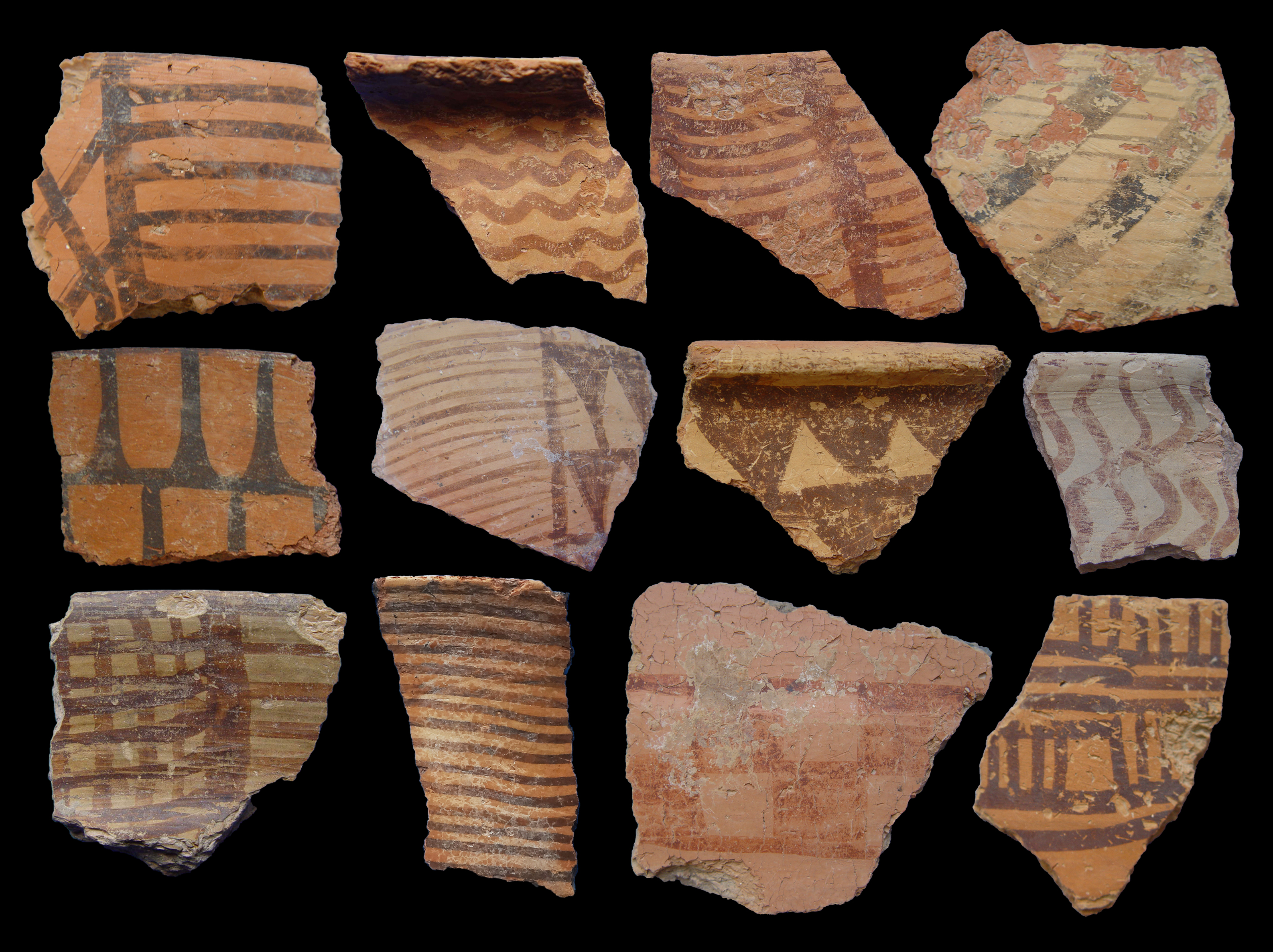
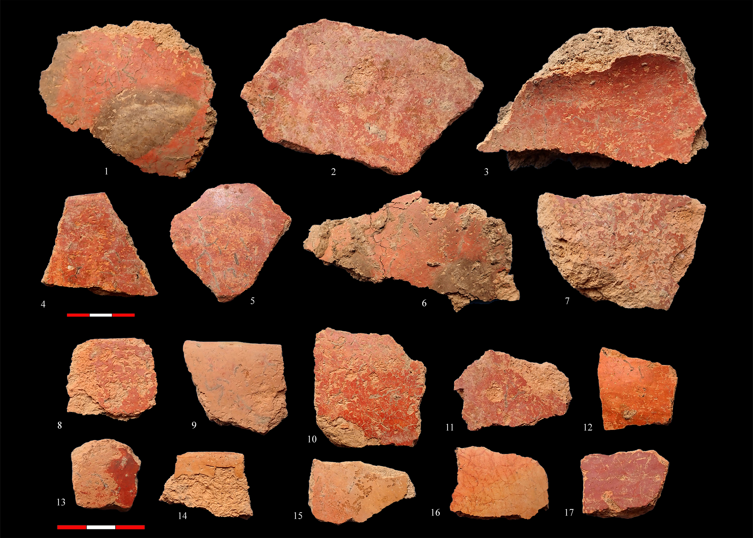
The East Mound is much larger than the West Mound, occupying ca. 1.9 ha, and stands some 5–6 m above its surrounding ground. The Japanese excavation at the mound resulted in approximately 1300 m2 of exposure in four large operations (Figure 2), divided, from top to bottom, into six architectural levels (I–VI) (Masuda Reference Masuda1984: Fig. 1). The mud brick constructions of the EM exhibited marked differences from those of the WM regarding the surface plan and internal features (Masuda Reference Masuda1984; Tsuneki Reference Tsuneki, Tsuneki, Nieuwenhuyse and Campbell2017: Figs. 11.6, 11.7). From its earliest levels, the EM produced numerous painted and plain ceramics (Masuda et al. Reference Masuda, Gotō, Iwasaki, Kamuro, Furusato, Ikeda, Tagaya, Minami, Tsuneki, Matthews and Fazeli Nashli2013; Figure 14.12; Tsuneki 1982; Figures 5–8). This handmade, chaff-tempered, usually tan-slipped ceramic is easily identifiable due to the high frequency of painted vessels bearing characteristic designs (Figure 4). In addition to goats, domesticated sheep and cattle are now represented in the faunal assemblage, and the plant subsistence of the inhabitants incorporates free-threshing wheat as well. Based on several sets of AMS dates, the occupation of the EM lasted from ca. 6200–5300 cal BCE (Roustaei et al. Reference Roustaei, Mashkour and Tengberg2015; Tsuneki Reference Tsuneki, Tsuneki, Nieuwenhuyse and Campbell2017; see below).
A selection of typical painted ceramics of the Chakhmaq Culture from the Shahroud area sites (not to scale).

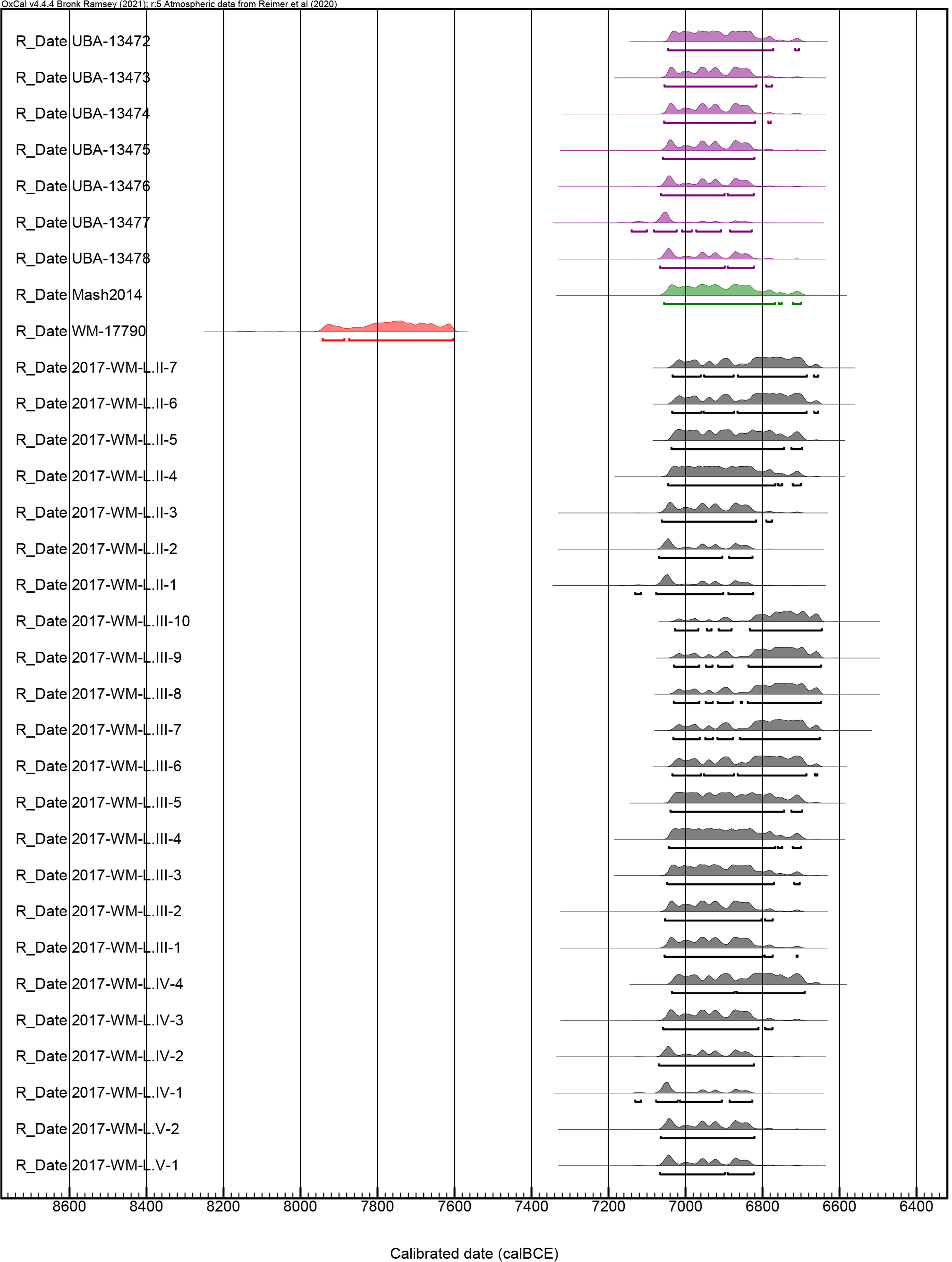
Recalibrated dates for the WM sequence. Color index: Gray (Nakamura Reference Nakamura and Tsuneki2014, Fig. 1; Tsuneki Reference Tsuneki, Tsuneki, Nieuwenhuyse and Campbell2017, Fig. 11.3), Red (Masuda et al. Reference Masuda, Gotō, Iwasaki, Kamuro, Furusato, Ikeda, Tagaya, Minami, Tsuneki, Matthews and Fazeli Nashli2013, Table 14.3), Green (Mashkour et al. Reference Mashkour, Vigne, Mohaseb, Bémili, Reynolds, Daujat, Debue, Tsuneki and Tsuneki2014: 31), Purple (Roustaei et al. Reference Roustaei, Mashkour and Tengberg2015, Table 3).

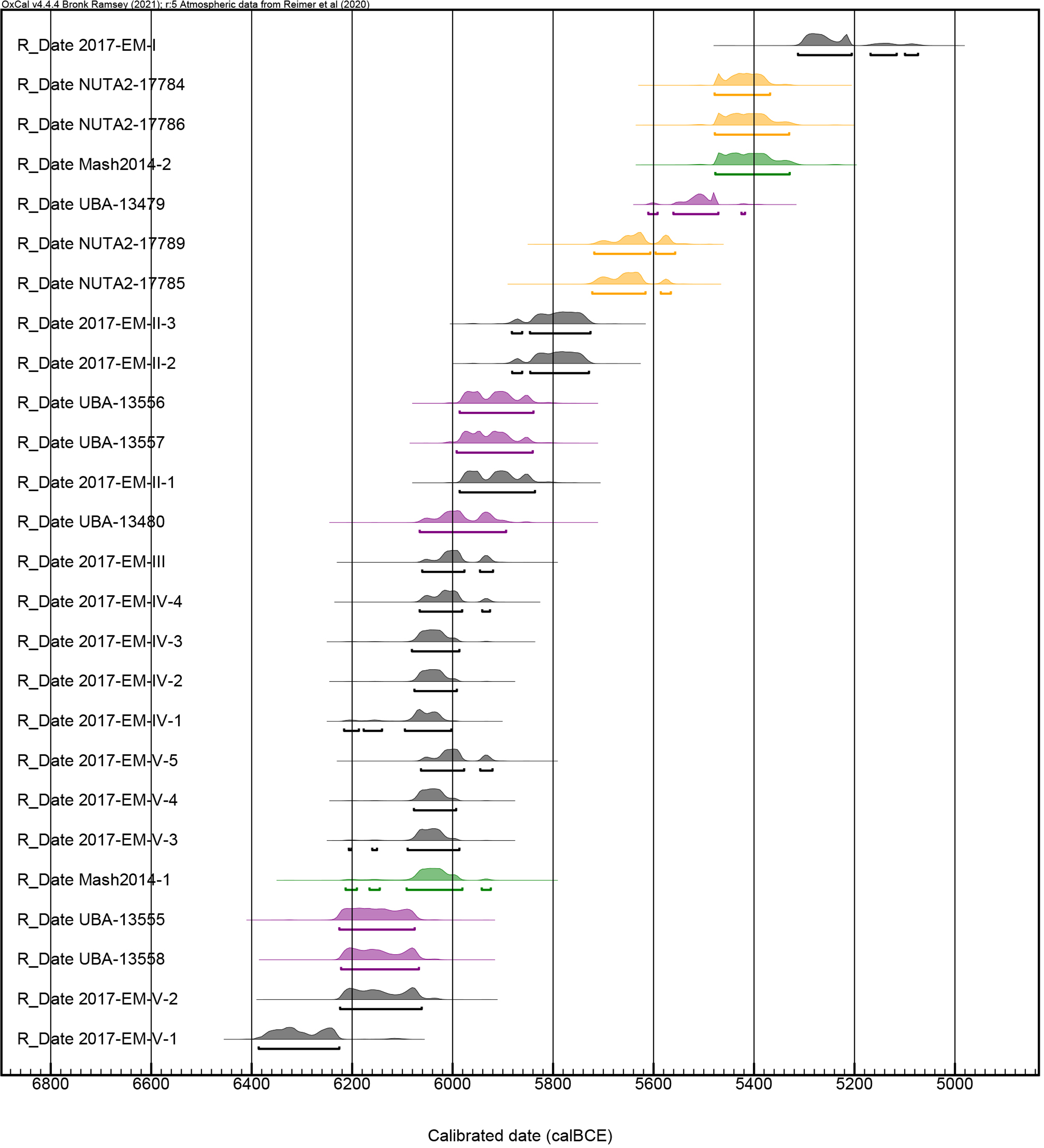
Recalibrated dates for the EM sequence. Color index: Gray (Nakamura Reference Nakamura and Tsuneki2014, Fig. 1; Tsuneki Reference Tsuneki, Tsuneki, Nieuwenhuyse and Campbell2017, Fig. 11.3), Purple (Roustaei et al. Reference Roustaei, Mashkour and Tengberg2015, Table 3), Green (Mashkour et al. Reference Mashkour, Vigne, Mohaseb, Bémili, Reynolds, Daujat, Debue, Tsuneki and Tsuneki2014: 31), Yellow (Masuda et al. Reference Masuda, Gotō, Iwasaki, Kamuro, Furusato, Ikeda, Tagaya, Minami, Tsuneki, Matthews and Fazeli Nashli2013, Table 14.3).

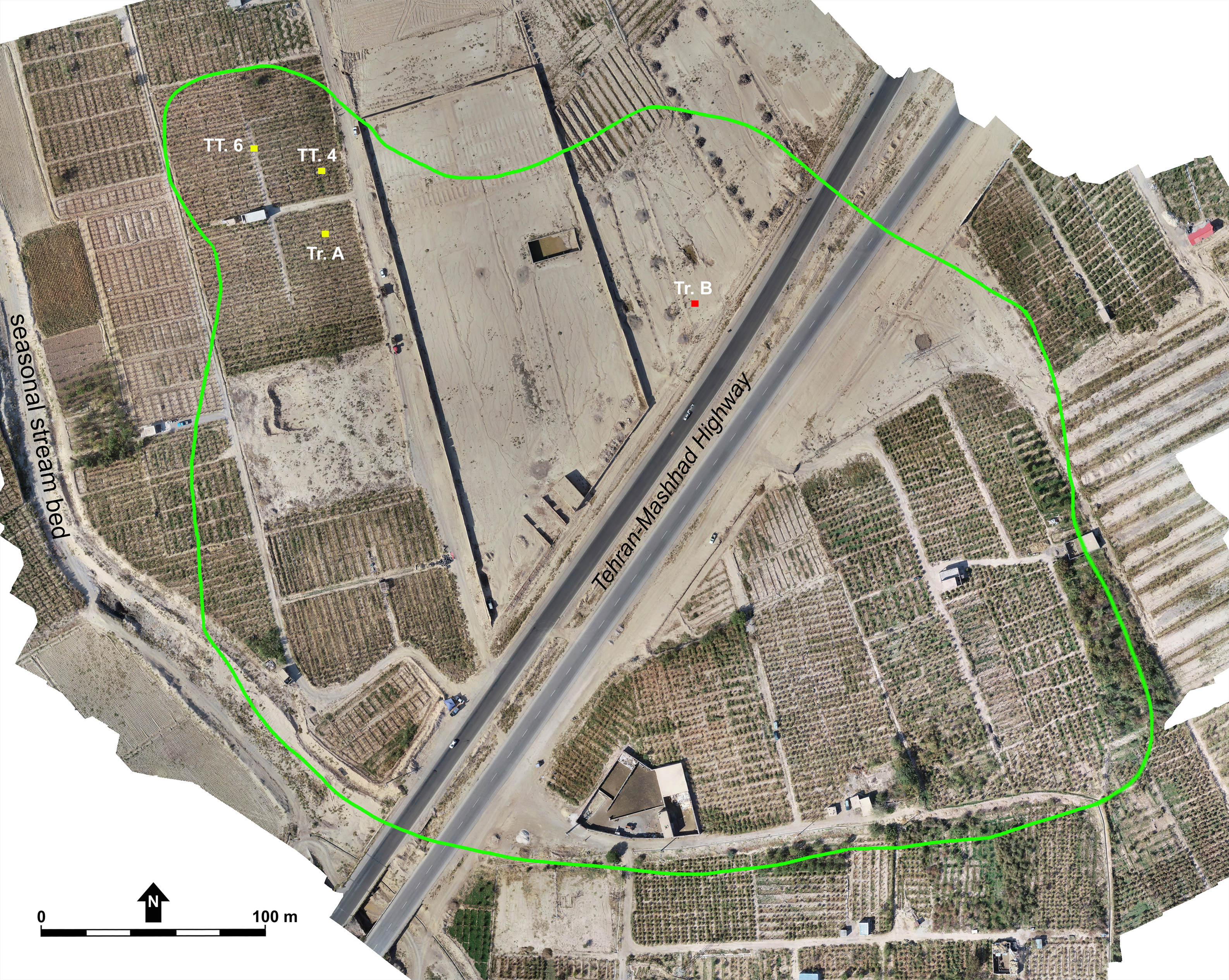
Drone photo of Rouyan and the location of Trench A, Trench B, and Test Trenches 4 and 6.

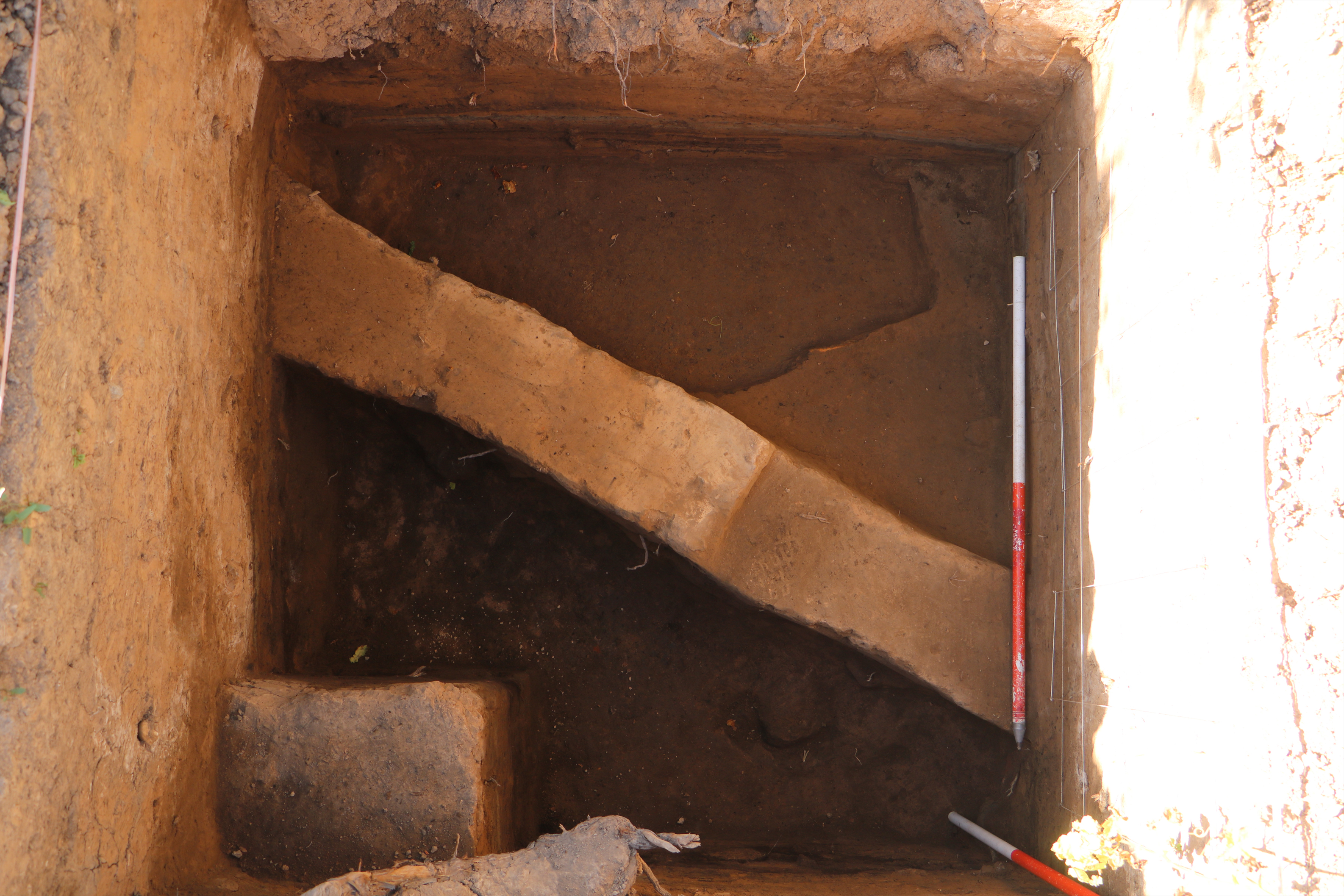
The mud brick wall unearthed in Test Trench 4.

Since the early 2000s, our understanding of the Neolithic of northeast Iran has improved significantly, thanks to multiple fieldworks conducted on both sides of the Alborz Mountain. The number of identified Neolithic sites of the region, which was limited to the three sites of Turang Tappeh, Yarim Tappeh, and Sang-e Chakhmaq, was multiplied through reconnaissance surveys (e.g., Roustaei Reference Roustaei2012) and reappraisal of archival ceramic assemblages from previous archaeological surveys (Roustaei and Nokandeh Reference Roustaei and Nokandeh2017), reaching a staggering 70 sites, all belonging to the ceramic phase of Chakhmaq Culture as suggested by the ceramic assemblages identical to that of the EM. Excavations at several sites across the region, such as Kalateh Khan and Deh Kheir in the Shahroud area (Rezvani and Roustaei Reference Rezvani, Roustaei, Roustaei and Mashkour2016; Roustaei Reference Roustaei, Roustaei and Mashkour2016b), Qaleh Khan and Tappeh Pahlevan in northern Khorasan (Azizi Kharanaghi et al. Reference Azizi Kharanaghi, Thomalsky, Khanipoor and Jafari2016; Garazhian et al. Reference Garazhian, Papoli Yazdi and Fakhr-e Ghaemi2014), and Aq Tappeh in the Gorgan Plain (Malek Shahmirzadi and Nokandeh Reference Malek Shahmirzadi and Nokandeh2000) (Figure 1), produced not only further information on different aspects of the Chakhmaq Culture, such as subsistence economy, dating, and material culture, but also provided new insights into the cultural ties between Chakhmaq and Jeitin Cultures (Roustaei Reference Roustaei2014, Reference Roustaei, Babbaf-Khaniki and Amini2021).
Notwithstanding this new information on the Neolithic of northeast Iran, multiple issues remained to be addressed in further detail, particularly the apparent temporal gap between the WM and EM. Based on archaeological evidence, the Japanese and other scholars acknowledged a chronological distance between the two mounds, confirmed later by multiple 14C dates (e.g., Harris Reference Harris2010; Kohl Reference Kohl1984; Masuda et al. Reference Masuda, Gotō, Iwasaki, Kamuro, Furusato, Ikeda, Tagaya, Minami, Tsuneki, Matthews and Fazeli Nashli2013). Most scholars considered the WM as an aceramic or “partially aceramic” Neolithic site due to the occurrence of a handful of ceramic fragments, as opposed to the EM, which represented a classic ceramic Neolithic occupation (Kohl Reference Kohl1984; Thornton Reference Thornton, Matthews and Fazeli Nashli2013). Despite dozens of Neolithic sites identified in northeast Iran during the past two decades (Roustaei and Nokandeh Reference Roustaei and Nokandeh2017), the transition problem between the two mounds persisted because none of the new sites corresponded with this temporal hiatus.
The occupational sequence corresponding with the temporal hiatus between the WM and EM has recently been documented at a Neolithic site, Rouyan, only 13 km south of the type site Sang-e Chakhmaq in the Shahroud Plain. The data obtained from two seasons of excavations at Rouyan also provided tangible evidence of the earliest occurrence of ceramics in northeast Iran, which is contemporary with the WM examples dated to the early seventh millennium BCE. By presenting the new 14C dates from Rouyan, this article aims to discuss the absolute chronology of Chakhmaq Culture from the late 8th to late 6th millennium BCE. It also deals with the issue of ceramic’s earliest manifestation in northeast Iran’s Neolithic contexts.
Absolute chronology of Chakhmaq Culture: A view from the type site
Masuda, the director of the Japanese team, published the first 14C dates for Tappeh Sang-e Chakhmaq in the 1970s (Masuda Reference Masuda and Bagherzadeh1972, Reference Masuda and Bagherzadeh1974). His first brief report published two raw radiocarbon dates from the EM: 7240±150 BP and 7270±125 BPFootnote 1. He did not mention the sample material or the level at which they came from. Several decades later, the calibration of these dates by D. Harris (Reference Harris2010, 63) and J. Marshall (Reference Marshall2012, 284) showed a date would fall between ca. 6450–5850 cal. BCE. Our recalibration of these raw dates gives the dates that fall between 6423—5835 and 6415–5910 cal BCE, respectively. Based on the criteria discussed in her study, such as the lack of lab code, context, and sample material, Marshall has considered these dates “unreliable” (Marshall Reference Marshall2012, 219–222, 284). Another concern about these dates is their broad probability distribution of 400–500 years, undermining their usefulness.
Masuda also published a third raw date from the WM, 7800 BP, lacking a ± margin of error. The exact level of the sample that is dated is not known because in different reports, he states the “second level” (Masuda Reference Masuda and Bagherzadeh1974, 25) or “third level” (Masuda Reference Masuda and Bagherzadeh1976, 65). The calibration of this date gives the 7100–6350 cal BCE (Harris Reference Harris2010, 63) and ca. 7000–6500 cal BCE timeframe (Weeks Reference Weeks and Potts2013, 56). The lack of margin of error and the broad probability distribution make this date problematic.
During her studies of animal bones from the Japanese excavations, M. Mashkour conducted the AMS dating on animal bones from both mounds: two samples from the WM and “several” samples from the EM (Mashkour et al. Reference Mashkour, Vigne, Mohaseb, Bémili, Reynolds, Daujat, Debue, Tsuneki and Tsuneki2014)Footnote 2. According to Mashkour et al. (Reference Mashkour, Vigne, Mohaseb, Bémili, Reynolds, Daujat, Debue, Tsuneki and Tsuneki2014, 31), “two very similar dates show that western mound was occupied by 7997±42 BP (7059–6767 cal. BC at %95 confidence), and several new dates for the East Mound range from 7182±42 BP (6110–5985 cal. BC) and 6444±42 BP (5497–5338 cal. BC)”. The recalibration of these dates has been shown in Figures 5 and 6. Although the levels from which these samples were taken are not specified, notably, the later date from the EM represents one of the latest dates available for Chakhmaq Culture (Figure 6). From what we know from the absolute dates of the EM sequence, it is clear that the samples from the EM were taken from the lowermost and uppermost levels (see below).
In an English translation of Masuda’s 1977 preliminary report in Japanese, the results of five animal bone samples directly dated by the AMS method from both mounds were published, four from the EM and one date from the WM (Masuda et al. Reference Masuda, Gotō, Iwasaki, Kamuro, Furusato, Ikeda, Tagaya, Minami, Tsuneki, Matthews and Fazeli Nashli2013: Table 14.3). The WM date (7945–7610 cal. BC) is clearly out of the temporal range established for the site’s sequence by Roustaei et al. (Reference Roustaei, Mashkour and Tengberg2015) and Tsuneki (Reference Tsuneki, Tsuneki, Nieuwenhuyse and Campbell2017) (Figure 5; see below). The four dates for the EM are from the upper two levels: three from Level II and one from Level I, suggesting a time range from ca. 5700–5350 cal. BCE (Figure 6).
In a workshop about Tappeh Sang-e Chakhmaq held in 2014 at Tsukuba University, 37 AMS dates from both mounds were published: 23 for the WM and 14 for the EM sequences (Nakamura Reference Nakamura and Tsuneki2014)Footnote 3. The WM dates range from ca. 7100–6650 cal. BCE (Figure 5). Notably, all date ranges are more or less similar. In the case of the EM, 13 out of the 14 dates from Levels V–II suggest a continuous occupation from ca. 6300–5700 cal. BCE, while the only date from Level I would fall between 5313–5074 cal BCE (Figure 6). This dichotomy made Nakamura hypothesize that there would be a possible “gap” between ca. 5700 and 5300 BCE in the EM sequence (2014, 10), a notion that was also mentioned cautiously by A. Tsuneki, who directed this dating program and published these dates once again in 2017 (Tsuneki Reference Tsuneki, Tsuneki, Nieuwenhuyse and Campbell2017; see below).
The next series of 14C dates from Sang-e Chakhmaq comes from the 2009 revisiting sounding (Roustaei et al. Reference Roustaei, Mashkour and Tengberg2015, Table 3, Fig. 12). Seven charcoal samples from the WM and six samples from the EM were analyzed using the AMS method (Figures 5 and 6). The dates for the WM show a relatively same time range, ca. 7100/7050–6700 cal BCE, almost identical to the results of the 2014 Japanese dating (Nakamura Reference Nakamura and Tsuneki2014, Fig. 1; Tsuneki Reference Tsuneki, Tsuneki, Nieuwenhuyse and Campbell2017, Fig. 11.3). The dates from the EM come from two trenches some 80 m apart, Trench 1 (five dates) and Trench 2 (one date). The Trench 1 dates, from a 4.5-m-thick sequence from the mound’s surface to virgin soil, corresponding with the Japanese Levels VI-III, suggest a relatively similar time range of ca. 6200–5850 cal BCE (Roustaei et al. Reference Roustaei, Mashkour and Tengberg2015: 590–591, Figs. 7 and 12, Table 3). The only date from Trench 2, excavated on the highest point of the site, where the Japanese unearthed the latest levels of the EM (Levels I and II), ranges from 5550–5474 cal BCE (Figure 6).
Each of the aforementioned dating attempts has contributed, in one way or another, to building a relatively secure temporal framework for the site as the type site of the Chakhmaq Culture. Of these, the two datings published by Nakamura (Reference Nakamura and Tsuneki2014)/Tsuneki (Reference Tsuneki, Tsuneki, Nieuwenhuyse and Campbell2017) and Roustaei et al. (Reference Roustaei, Mashkour and Tengberg2015) are notable because they provide multiple sequential dates for each mound’s sequence, from the lowest to the latest levels. Based on the two series of 14C dates, the WM can be dated to ca. 7100/7000–6700/6650 cal BCE; the two dates published by D. Harris and M. Mashkour (Harris Reference Harris2010, 63; Mashkour et al. Reference Mashkour, Vigne, Mohaseb, Bémili, Reynolds, Daujat, Debue, Tsuneki and Tsuneki2014, 31) conform to this range, too.
The two sets of 14C from the EM published by Nakamura (Reference Nakamura and Tsuneki2014)/Tsuneki (Reference Tsuneki, Tsuneki, Nieuwenhuyse and Campbell2017) and Roustaei et al. (Reference Roustaei, Mashkour and Tengberg2015) are very similar, suggesting ca. 6200–5300 cal BCE for the mound sequence. The reason is that in the 2009 sounding, the stratigraphic trench (Trench 1) was excavated on the edge of the Japanese Main Trench, which yielded the earliest levels of the site (Levels VI–III). Although, as mentioned before, both Nakamura (Reference Nakamura and Tsuneki2014) and Tsuneki (Reference Tsuneki, Tsuneki, Nieuwenhuyse and Campbell2017) surmised a possible temporal gap in the EM sequence, corresponding with ca. 5700–5300 BCE, the single date from Trench 2 of 2009 sounding (Roustaei et al. Reference Roustaei, Mashkour and Tengberg2015, Table 3), the date published by Harris and Mashkour (Harris Reference Harris2010, 63; Mashkour et al. Reference Mashkour, Vigne, Mohaseb, Bémili, Reynolds, Daujat, Debue, Tsuneki and Tsuneki2014, 31), and, more importantly, the four dates for Levels II and I published in Masuda et al. (Reference Masuda, Gotō, Iwasaki, Kamuro, Furusato, Ikeda, Tagaya, Minami, Tsuneki, Matthews and Fazeli Nashli2013, Table 14.3) fill this alleged gap (Figure 6). Therefore, the EM sequence represents a continuous occupation without interruption from ca. 6200–5300 cal BCE.
There is a slight problem with the earliest date of the EM, from Level V (sample code 2017 EM-V1 in Figure 6), published by the Japanese (Nakamura Reference Nakamura and Tsuneki2014; Tsuneki Reference Tsuneki, Tsuneki, Nieuwenhuyse and Campbell2017), which needs further consideration. Recalibration of this date gives a 2-sigma calculated range of 6387–6226 cal BCE, which falls a little out of the other four dates’ range from the same level, i.e., ca. 6200–5950 cal BCE. On the other hand, the earliest date of 2009 sounding, from a sample taken just above virgin soil—which can be correlated with the Japanese Level VI—would fall between 6217–6067 cal BCE, consistent with the Japanese four dates from Level V (Figure 6). Based on this argument, the single date from Level V may be problematic and could be excluded.
Upon the above discussion, it is clear that there is a temporal hiatus of several centuries between the occupational sequences of the two mounds. Given the uncertainty about the exact time of the beginning of the occupation and the total abandonment of each mound, this hiatus could be between 400–500 years, from ca. 6700/6650–6300/6200 BCE. This settlement hiatus in the Sang-e Chakhmaq sequence is critical because it represents a significant development period in northeast Iran’s cultural history. Briefly, this period witnessed the beginning of ceramic production on an increasing scale to meet society’s increasing need for new, more effective containers. Additionally, a significant change occurred in the subsistence economy from the WM to the EM during this period. While the domesticated status of sheep was uncertain in the WM, it is now well-attested in the EM faunal assemblage. Moreover, absent in the WM, domesticated cattle are now part of the EM inhabitants’ diet (Roustaei et al. Reference Roustaei, Mashkour and Tengberg2015). This period also represents a significant change in some aspects of the material culture from the WM to the EM, such as architecture (see above). Besides, the long-distance exchange system of Anatolian obsidian exhausted significantly during this period, as evidenced by the relative frequency of this exotic material in the WM chipped stones and its almost lack in the EM (Masuda et al. Reference Masuda, Gotō, Iwasaki, Kamuro, Furusato, Ikeda, Tagaya, Minami, Tsuneki, Matthews and Fazeli Nashli2013; Roustaei and Gratuze Reference Roustaei and Gratuze2020), indicating a significant change in inter-regional interactions.
The Site of Rouyan
The archaeological site of Rouyan (36°22’41.50 “N; 54°59’16.53 “E) lies on the southern outskirts of Shahroud (Figure 1). Nowadays, this inconspicuous site has no height above the surrounding ground, but based on local information, before it was flattened (to an unknown scale) for making orchards, vineyards, and croplands a few decades ago, it had a gullied, undulate landscape (Figure 7).
The site of Rouyan was discovered in the fall of 2015 and was excavated in two consecutive seasons in 2018. The objective of the first season was to delimitate the site’s actual limit by excavating some test trenches on the approximate edge of the site. In total, 23 small trenches, mostly 110×160 cm, were excavated around the approximate limits of the site (Roustaei and Rezvani Reference Roustaei and Rezvani2021). Based on multiple trenches excavated into virgin soil, the depth of archaeological deposits is estimated to be about four meters, all below the ground surface (for further details, see Roustaei and Rezvani Reference Roustaei and Rezvani2021). By interpreting the nature of encountered deposits in the test trenches, whether they were in situ or not, we could define the approximate real extent of the site at ca.12 ha, making it the largest known Neolithic site throughout northeast Iran (Figure 7; Roustaei and Rezvani Reference Roustaei and Rezvani2021, Fig. 6).
While most test trenches produced the characteristic painted ceramic identical to the EM corpus, a few test trenches on the northwestern part of the site revealed sequences with only a handful of plain ceramics similar to those recovered from the WM, along with lithic collections. The paucity of ceramic and the lack of painted ones from these trenches indicated that we faced a pre-EM sequence in this part of the site, which might fill the temporal hiatus between the Sang-e Chakhmaq mounds (see below).
Evidence from the delimitation sounding at Rouyan
The first evidence from Rouyan of an occupation corresponding with the temporal hiatus between the WM and EM sequences was obtained from Test Trench 4, 1.5×1.5 m, in the northwest corner of the site (Figure 7). Without reaching virgin soil, the trench was excavated to a depth of 155 cm below the surface, where a mud brick wall was uncovered across the trench (Figure 8). The excavated sequence produced only eight plain, red-slipped, burnished sherds, obviously different from the well-known EM assemblage, which is dominated by the painted ceramic, but, instead, resembling the few ceramics recovered from the early seventh millennium BCE contexts of the WM (Figure 3: 7–9). This observation could indicate that we were digging in a pre-6200 BCE context, a notion that was confirmed by a single radiocarbon determination from Locus 405 at a depth of 153 cm below the surface, which gives a date of ca. 6800–6600 cal BCE (see Table 2).
Excavation at Test Trench 6, some 30 m west-northwest of Test Trench 4 (Figure 7), provided further evidence of a probable occupation predating the EM sequence. This 1.3×1.8 m trench was excavated to virgin soil 412 cm below the surface. The excavated sequence of this trench can be divided into two parts. The upper half was essentially an accumulated mass of dirt and gravel with almost no sign of stratification or ordinary, in situ archaeological deposit but rather an amorphous accumulation with occasional, out-of-context sherds (Roustaei and Rezvani Reference Roustaei and Rezvani2021, 259, Fig. 12). The lower half contained deposits with increasing stratification and high contents of ash, charcoal, animal bones, occasional lithics and plain sherds, and bone objects—clearly of anthropogenic origin—as one dug deeper. The small ceramic assemblage (29 pieces) recovered from Test Trench 6 conforms to its stratigraphy: ceramic fragments of the upper half are heavily corroded, which confirms the disturbed nature of the deposits, but those of the lower half of the sequence are burnished, red-slipped ware with high amounts of vegetal matter as temper, similar to those from Test Trench 4 and also to a few examples recovered from the WM (Figure 3: 10–11). Although no radiocarbon date is available from this trench, its small ceramic assemblage, lacking the ubiquitous painted version of the EM type, indicates that its sequence can be dated to before ca. 6200 BCE. Notably, except for the two trenches of 4 and 6, none of the delimitation trenches produced similar, exclusively plain, red-slipped sherds but yielded the familiar painted ceramics of the EM type. This ceramic occurrence pattern led us to hypothesize that the northwestern part of Rouyan contained occupational deposits predating the EM sequence, including the temporal hiatus between the WM and EM sequences. This inference stimulated us to conduct a systematic stratigraphic excavation in the second season to get more concrete evidence of this crucial time range.
Evidence from the stratigraphic excavation at Rouyan
The stratigraphic excavation at Rouyan was meant to address two issues: first, seeking the archaeological materials corresponding to the temporal hiatus between the WM and EM sequences, and second, documenting the transition between the Chakhmaq Culture and Cheshmeh Ali Culture in terms of ceramic developments (see Roustaei and Rezvani Reference Roustaei and Rezvani2021). To address these issues, we opened two small trenches, Trench A and Trench B, some 160 m apart, where they could provide promising results based on our findings from the delimitation sounding (Figure 7). Here, only the results of Trench A are discussed, as they are relevant to our discussionFootnote 4.
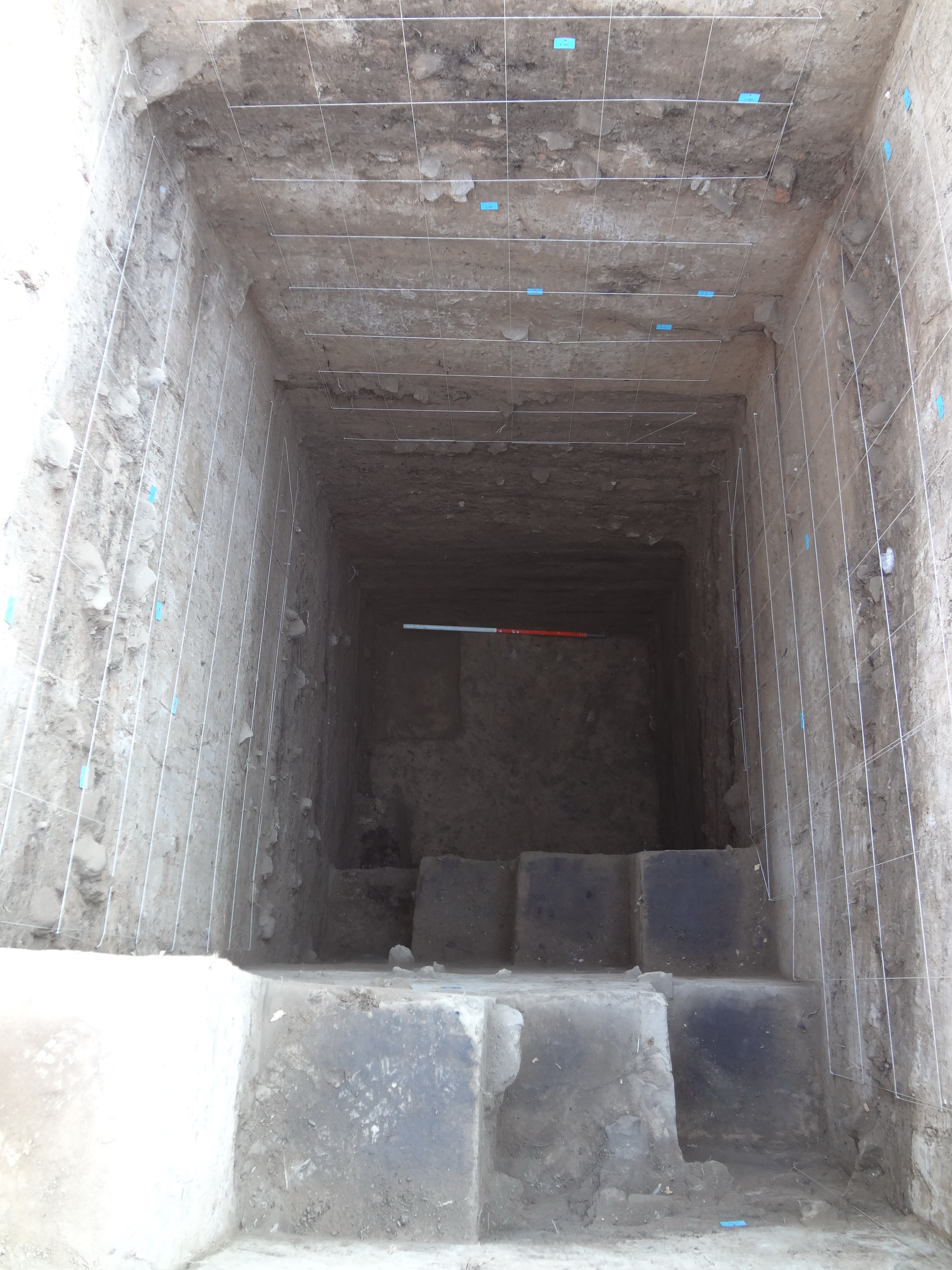
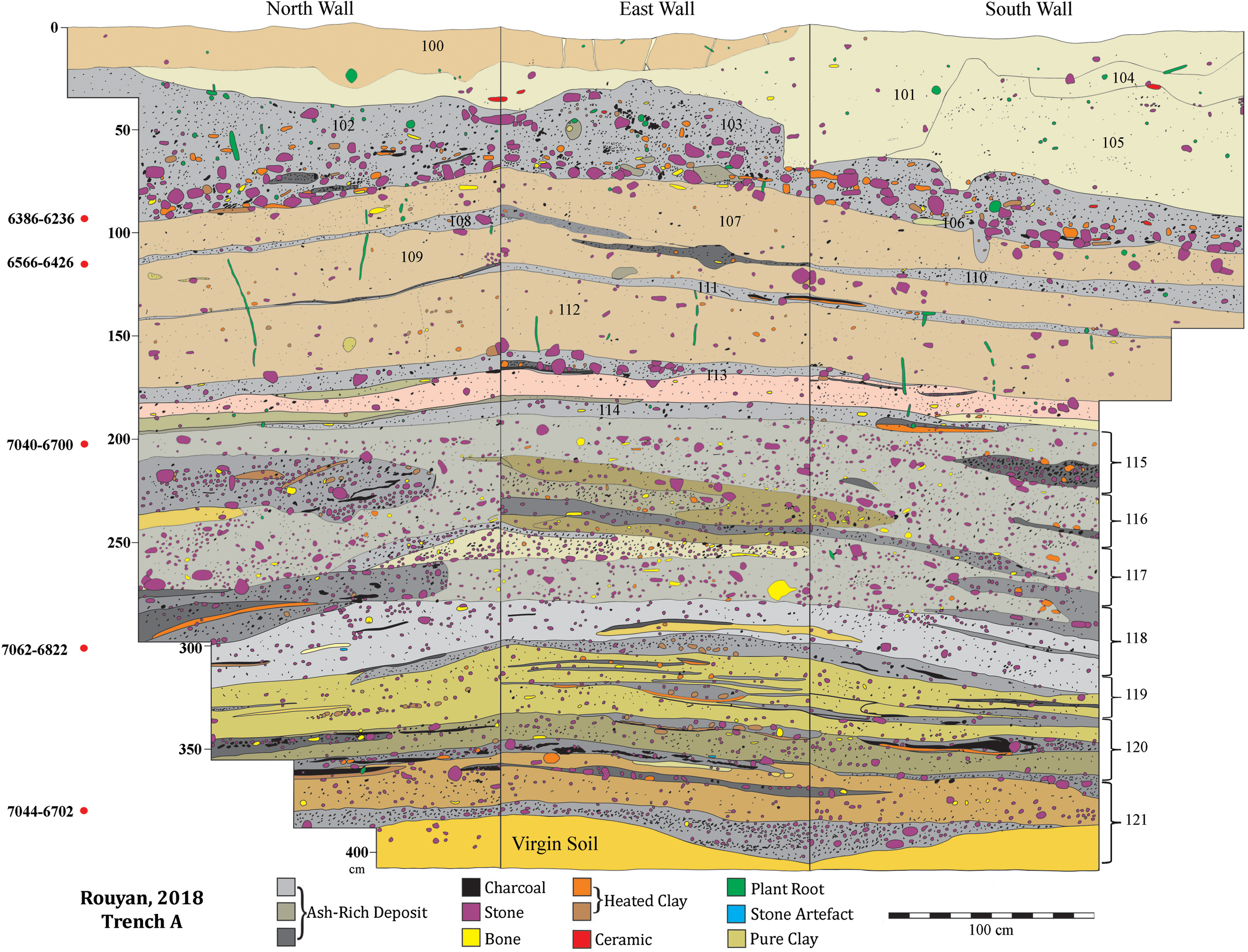
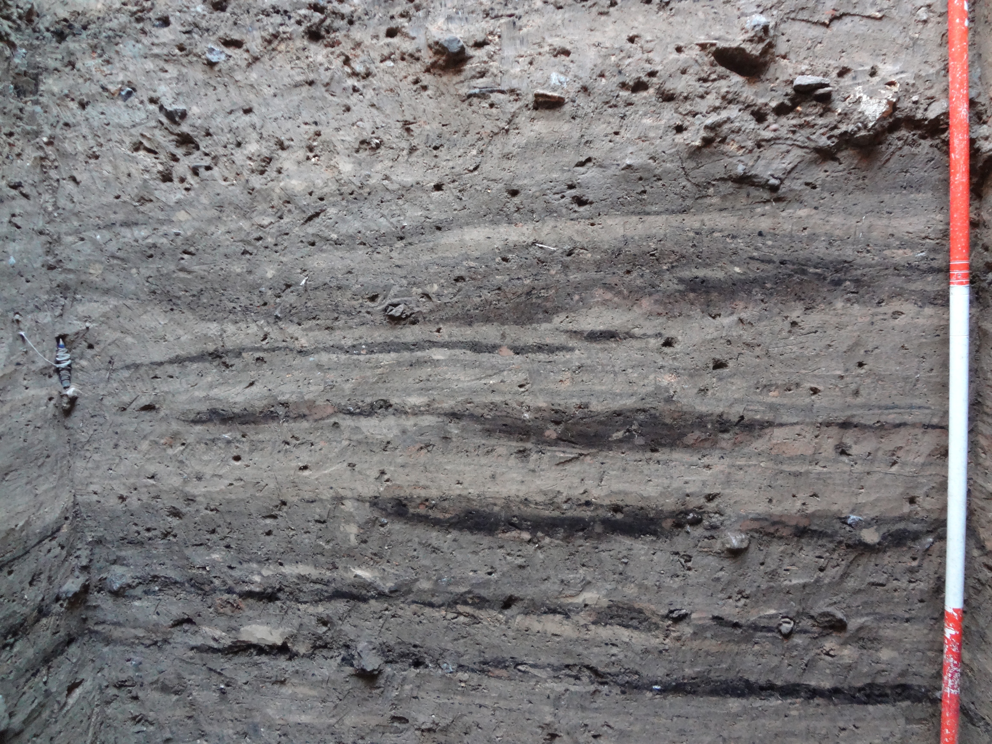
Trench A, 210×150 cm, was opened some 25 m south of Trench 4 (Figure 7). The trench was excavated to virgin soil at 410 cm below the surface (Figure 9), and its sequence was divided into 22 loci (L. 100–121), top to bottom (Figure 10). No architecture was found, but primarily loose deposits of various kinds. Based on both the nature and mode of formation of the deposit, the excavated sequence can be divided into five units from top to bottom: Unit 1, consisting of loci 100, 101, 104, and 105, was reworked top soil with occasional, out-of-context sporadic ceramics and lithics. Of these, the loci 101, 104, and 105 were heavily silty or clayey silt in nature. Unit 2, consisting of loci 102, 103, and 106, was the loose remains of the same fireplace or daily refuse with numerous burnt, fire-cracked stones, very rich in ash and charcoal, and shattered, blackened animal bones, in addition to plain ceramics and chipped stones. Unit 3, consisting of loci 107–112, represented a series of hard, clayey deposits, specifically loci 107, 109, and 112, separated by several thin ash/charcoal-rich lenses. Although no trace of architectural remains was found, the nature of this unit, along with the scarcity of ceramic and lithics, indicates that it likely represents the crumbled and disintegrated mud brick/pisé architecture. Unit 4, represented by loci 113–117, is a 1.2-m-thick, gravelly deposit rich in ash/charcoal, animal bones, and lithics. This unit also featured a series of clayey lenses dotted with numerous charcoal flecks. Unit 5, represented by loci 118–121, was a series of clayey layers rich in ash/charcoal, lithics, animal bones, and, in its lower half, rich in small, angular gravel (Figure 11).
Trench A at the end of excavation.

The line drawing of Trench A’s north, east and south walls.

A close view of the Trench A north wall showing repeated ash/charcoal lenses (Unit 5).

Radiocarbon dates
There are 12 radiocarbon dates available for Rouyan, both from the delimitation sounding and stratigraphic excavation. Of these, those of Trench A (5 dates) and Test Trench 4 (1 date) are relevant to our discussion; the other dates cover the sixth millennium BCE sequence of the site unearthed in other trenches, which is out of the present paper’s scope (Roustaei and Rezvani Reference Roustaei and Rezvani2021; Roustaei Reference Roustaei2023).
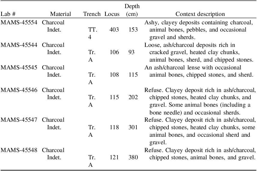
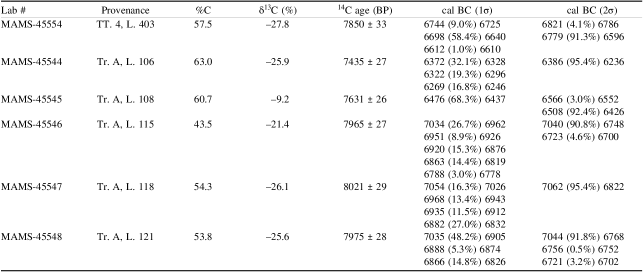
The samples were all wood charcoal, taken from the sealed contexts using the tip of a trowel and then wrapped in aluminum foil. Table 1 provides the samples’ contextual and stratigraphic specifications. The AMS 14C dating was carried out by the Curt-Engelhorn Zentrum Archaometrie (CEZA), Mannheim, Germany. The samples were pretreated using the ABA method (Acid/Base/Acid) with HCl, NaOH, and HCl. The insoluble part is then further processed. The 14C content was measured using a MICADAS-type AMS system. The 14C/12C and 13C/12C isotope ratios of samples, calibration standards (oxalic acid-II), blanks, and control standards were measured simultaneously in the AMS. The determined 14C ages are standardized to δ13C = –25‰ (Stuiver and Polach Reference Stuiver and Polach1977) and calibrated to calendar ages using the IntCal20 calibration curve (Reimer et al. Reference Reimer, Bard, Austin, Bayliss, Blackwell, Bronk Ramsey, Butzin, Cheng, Edwards, Friedrich, Grootes, Guilderson, Hajdas, Heaton, Hogg, Hughen, Kromer, Manning, Muscheler, Palmer, Pearson, van der Plicht, Reimer, Richards, Scott, Southon, Turney, Wacker, Adolphi, Büntgen, Capano, Fahrni, Fogtmann-Schulz, Friedrich, Köhler, Kudsk, Miyake, Olsen, Reinig, Sakamoto, Sookdeo and Talamo2020) in the OxCal 4.4.4 calibration program (Bronk Ramsey Reference Bronk Ramsey2021).
The samples’ contextual specifications

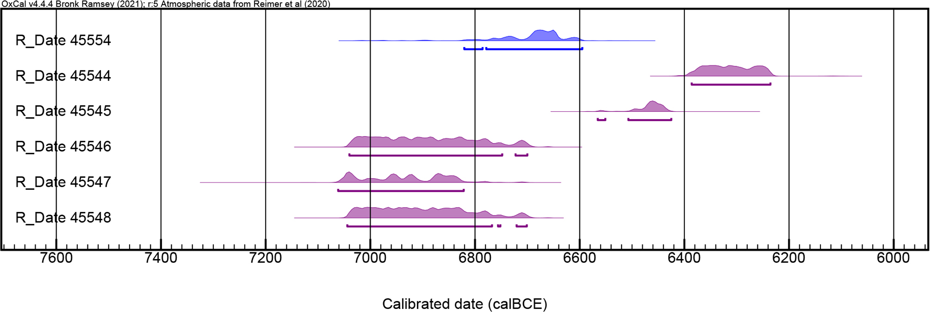
The AMS dates from Trench A are consistent with their stratigraphic positions, covering several hundred years from the turn of the eighth to the last centuries of the seventh millennium BCE (Table 2; Figure 12). To better comprehend the implication of these dates to the excavated sequence, it is better to examine the mode of formation of different loci closely. The first point is about the lower half of the sequence, represented by loci 113–121 (Units 4 and 5) (Figure 10). Given the nature of the deposit, contents, texture, and other physical attributes, these loci share similar aspects, encouraging us to excavate them arbitrarily. Thus, from Locus 115 to virgin soil, the excavation proceeded in a metric way. This situation was not, however, the case for the upper half of the Trench A sequence, where noticeable differences between deposits led us to excavate them based on their natural stratification (Figure 10). Back to the lower half of the sequence, its various loci’s similar nature and contents implied that it could be accumulated quickly. This impression is confirmed by the three dates, MAMS-45548, MAMS-45547, and MAMS-45546, from the lower, middle, and upper part of this part of the stratigraphic column, showing almost the same time range, ca. 7050–6700 cal BCE (Table 2; Figure 12). It is difficult to suggest with certainty the probable agent of such thick accumulation highly rich in gravel, ash, and charcoal, with interbedded thin, burnt clay patches, although some observers consider such combination as the remains of a hearth. Notably, more than 90 percent of the chipped stones of the trench were retrieved from these loci (1470 out of 1617 pieces). The almost identical nature of these loci may also imply that the depositional agent of their creation was the same.
Radiocarbon dates from Rouyan (Trench A and Test Trench 4)

The 14C of Trench A (purple) and Test Trench 4 (blue) plotted in OxCal using INTCAL 20.

The only date of Unit 3 (MAMS-45545) comes from Locus 108, a thin ash-rich lens separating loci 107 and 109 (Figure 10). This date, ca. 6560–6430 cal BCE, is one or two centuries younger than that of Locus 115 of Unit 4, while their respective samples were distanced only 87 cm vertically. Here, the question arose as to what extent each deposit between these two samples was responsible for this time interval. Of the loci between loci 108 and 115, where the two consecutive radiocarbon samples were taken, loci 110 and 111 were thin ash-rich lenses overlying the thick, hard, clayey deposits of loci 109 and 112, respectively (Figure 10). Indeed, regarding their spatial relationship, sandwiched between loci 107 and 109, the two loci 108 and 110 were part of the same occupational event, either remains of a fireplace or daily refuse of a nearby house. Given their mode of formation, these thin, ash-rich deposits (loci 108, 110, and 111) could have been built up shortly. Likewise, the loci 113 and 114, part of Unit 4, were probably built up shortly, as indicated by the resemblance between their nature and contents with the underlying deposit.
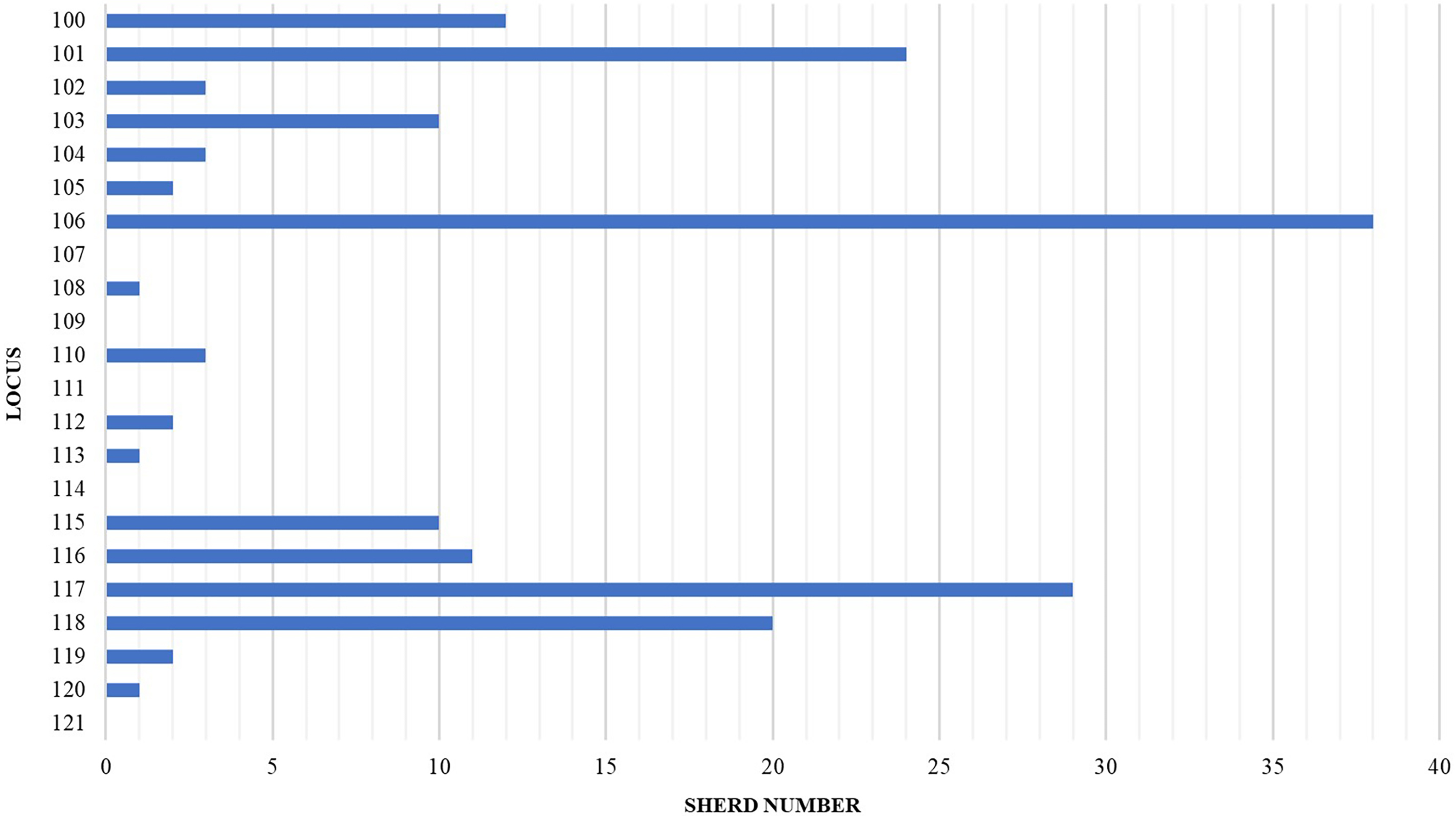
On the other hand, loci 107, 109, and 112, which comprise the bulk of Unit 3, can be interpreted differently. They consist predominantly of hard clay with occasional charcoal flecks, minimal ash contents, and a few gravels. This combination distinctly differs from the Units 2, 4, and 5 deposits (Figure 10). Although these loci provided no meaningful trace of architecture, their clayey nature, in addition to the fact that they yielded the minimum number of ceramic (see Figure 13) and chipped stones of the whole sequence—3.5 and 1 percent, respectively—indicate that they might be remains of some mud brick or pisé construction which expected to be poor in terms of artifacts. Therefore, anchoring on this scenario, it is possible to attribute the time interval between the two consecutive dates of MAMS-45546 and MAMS-45545 to a possible “construction phase” indicated by loci 109 and 112 of Unit 3. Alternatively, the time interval between the two dates may be due to other factors. Firstly, it could be due to a lack of 14C dates from the intermediate deposit between the dated loci. Secondly, it could be due to a lack of occupation at this spot of the site. Finally, it may represent a temporal gap in the site’s sequence. In the case of the latter, however, the single date from Test Trench 4 (ca. 6800–6600 cal BCE) suggests otherwise, filling, to some extent, the time interval between the two consecutive dates MAMS-45546 and MAMS-45545 of Trench A sequence, providing further evidence for the continuity of the 7th millennium BCE occupation at Rouyan (Table 2; Figure 12).
The number of sherds recovered from different loci of Trench A.

The mighty, hearth-like deposit of Unit 2, represented by loci 102, 103, and 106 (Figure 10), is radiocarbon dated to ca. 6380–6240 cal BCE (Table 1; Figure 8). Here, too, the date does not overlap with that of underlying Locus 108. In this case, Locus 107, very similar to loci 109 and 112, both interpreted as the remains of a possible “construction phase,” might be responsible for the 100–150 years interval between these dates, although it may represent a partial settlement gap in the trench’s spot.
There are some reservations about the discussed radiocarbon dates. The fact that all 14C samples of Rouyan are wood charcoal poses the potential challenge of the “old wood effect.” As the plant species of the analyzed samples were not specified, they could have been coming from bushes with a few years of life span or several hundred-year-old trees. Nevertheless, the diachronic order of the Trench A sequence’s 14C dates may somewhat ameliorate this issue. A further concern about the 14C dates is the calibration plateau, ranging from 240–340 years, which is exhibited by the three dates of the sequence’s lower half. Such a broad timeframe hinders detailed chronological resolution. Indeed, the two dates, MAMS-45548 and MAMS-45546, show an almost exact timeframe, ca. 7040–6700 cal BCE, while their corresponding samples distance almost two meters vertically. Notably, 14C dates of the contemporary WM show a similar calibration plateau (Figure 5).
Ceramic assemblage of Trench A
A relatively small collection of 172 sherds was recovered from the Trench A sequence (Figure 13). No sherd represented a complete profile except a rather large piece demonstrating a small vessel like a beaker (Figure 14:6). Although all units provided ceramic, it is notable that the earliest locus (121) produced no sherd, and the following two overlying loci (L. 120–119) yielded only three pieces altogether. As mentioned before, Unit 3 produced the least number of ceramic fragments of the sequence (6 pieces).
Ceramics from Trench A. 1, 2, 6, 12: L.106; 3, 4, 7, 10, 13, 16: L.117; 5, 15: L.118; 8: L.115; 9, 14, 17: L.116; 11: L.103; 18: L.101.

The ceramic collection of Trench A contained only plain sherds, except a single, small painted fragment, with an “oblique ladder” motif characteristic of the late phase of Chakhmaq Culture from the reworked surface deposit of Locus 101 (Figure 14:18; cf. Roustaei Reference Roustaei, Roustaei and Mashkour2016b, Fig. 24). Most sherds have been baked under low temperatures, evidenced by a gray-to-black core, making them somewhat fragile. Thus, the paste color cannot be determined except for a few specimens that experienced proper heat during baking, showing an orange or brownish-orange fabric. Except for three pieces from Unit 2, tempered with angular crushed stone, all sherds have been tempered with chopped vegetal matter; consequently, most sherds show a fabric with numerous tiny voids. Moreover, all the ceramic fragments bear a relatively thick clay slip, either red or tan, usually on exterior and interior surfaces. However, in some examples, two or more shades of color may be seen on the surface due to the variation in heat during baking.
Overall, the sherd collections of various units of Trench A show very similar attributes. Nevertheless, based on the color of the clay slip, the assemblage can be divided into two general categories: Red-Slipped Ware and Tan-Slipped Ware (Figures 15 and 16). The Red-Slipped Ware appears from the earliest ceramic-bearing deposit (Locus 120) and continues to Locus 115. The red color of the clay slip in this category shows a slight variation in different examples, yet the most common color is deep or purplish red (Figure 15). Almost all vessels are burnished, often on both the exterior and interior.
Red-Slip Ware (except #14), Trench A. 1, 3, 6, 10, 12, 15, 16: L.117; 2, 9, 11: L. 118; 4, 8, 14: L.116; 5, 17: L.119; 7: L.115; 13: L.120.

Tan-Slip Ware from Locus 106 (except #3, L. 102), Trench A.

The Tan-Slipped Ware starts in the sequence from Locus 118, almost along with but outnumbered by the Red-Slipped Ware, and continues until the top of the sequence with increasing frequency (Figure 16). Here, too, most vessels are burnished. An important point about the Tan-Slipped Ware is that it becomes the most frequent clay slip color during the whole sequence of the EM.
The diversity of vessel forms represented by the small ceramic assemblage of Trench A is limited (Figure 14). Nevertheless, the most common form is bowls, followed by jars and pots. Cups and vessels resembling a beaker are represented only by a single fragment.
In addition to the two foregoing categories, another ceramic group in the Trench A assemblage is represented by only a handful of sherds recovered from Unit 2. This type is a low-fired ceramic characterized by angular crushed stones in its fabric as temper (Figure 16: 4–6). Perhaps as an unsuccessful experience, this particular type of ceramic had no fortune in the subsequent boom of the Chakhmaq Culture ceramic tradition.
Discussion
The 14C dates from Trench A at Rouyan, augmented by that of Test Trench 4 and also archaeological evidence from Test Trench 6, fill in the long-standing temporal hiatus between the WM and EM sequences, i.e., ca. 6700/6650–6200 BCE (Figure 12). Five 14C dates from Trench A encompass a significant part of the seventh millennium BCE, from ca. 7050–6250 cal BCE. Given these dates, the lower half of the sequence, covering ca. 7050–6700 cal BCE (Figure 12), is contemporary with the whole sequence of the WM, while the upper half, ca. 6600–6200 cal BCE, corresponds with the temporal hiatus between the WM and EM sequences. To some extent, the single date from Test Trench 4 (ca. 6800–6600 cal BCE) bridges the two halves of the Trench A sequence. Altogether, these dates suggest that the occupation at Rouyan began almost simultaneously with that of the WM, around 7000 BCE, and continued throughout the seventh millennium BCE, unlike the WM, which was abandoned around 6700/6600 BCE. The existence of a calibration plateau, arching ca. 7100–6700 BCE, hampers the determination of which site was established first (Figures 5 and 12). Based on 14C dates and ceramic evidence from other excavated trenches, Rouyan continued its occupation throughout the sixth and perhaps the early fifth millennium BCE (see Roustaei and Rezvani Reference Roustaei, Babbaf-Khaniki and Amini2021; Roustaei Reference Roustaei2023).
The appearance of ceramic at Rouyan and the WM is an intriguing issue since they are amongst a handful of Neolithic sites in the Iranian Plateau that yield the earliest examples of authentic ceramic. During the first season of excavation at the WM, the Japanese found no ceramic from the WM, causing Masuda to claim that the site belonged to pre-pottery Neolithic (Masuda Reference Masuda and Bagherzadeh1972). However, three sherds were found in the second season, one from the third and two from the first level (Masuda Reference Masuda and Bagherzadeh1974). In 2014, Akira Tsuneki illustrated four ceramic fragments and stated that “A few small potsherds were discovered in Layer III of West Tappeh [Mound], all of which share common characteristics” (Tsuneki, Reference Tsuneki and Tsuneki2014, 13, Fig. 1). Later, he admitted that “It is not clear how many potsherds were discovered during the west tappeh excavations, but their number is thought to be no more than a dozen” (Tsuneki Reference Tsuneki, Tsuneki, Nieuwenhuyse and Campbell2017, 123). Perhaps we would not know the actual number of sherds in the Japanese excavation area of the WM, but given Tsuneki’s comment, we may hypothesize that there have been more ceramic fragments than what the Japanese recovered, a notion that gains support from the 2009 revisiting program. In our small trench at the WM, we found two ceramic fragments, both from the lower part of the sequence, just about 30 cm above virgin soil. Given the total excavation area, the meaningful difference between the number of ceramics recovered from the 2009 small sounding (∼ 4 m2) and those of the Japanese extensive excavations (∼ 480 m2) may imply that there would have been more ceramic fragments than the Japanese could recover. Notwithstanding the actual number of ceramic fragments within the excavated area of the WM, the sheer fact of their presence from the early phases of occupation—as evidenced by the two sherds recovered from lower levels from the 2009 sounding—indicates that the early dwellers of the WM were already familiar with making ceramic vessels. However, admittedly, this technology was in its infancy, as evidenced by the sporadic occurrence of ceramic.
The ceramic appearance pattern at Rouyan is almost similar to that of the WM; the earliest deposit of both sites yielded no ceramic, but it started immediately in the sequence (Figure 13). There is, however, a marked difference between these sites in terms of ceramic frequencies. While the whole sequence of the WM yielded a few ceramic fragments—or as many as a dozen, as Tsuneki surmised—the lower half of Trench A, which shows a similar timeframe as the WM, produced a larger sherd collection (Figure 13). There may be some alternative explanations for this difference in ceramic frequencies at two sites: first, it may indicate that the WM is slightly earlier than Rouyan, although their 14C dates show a similar timeframe. However, as we discussed earlier, the calibration plateau ranging from ca. 7100–6700 BCE is a challenge in determining which site was established earlier. Second, it may be due to the differential technological levels between the two almost contemporary settlements, although there is no evidence to support this claim. Based on the 14C dates of the earliest levels of WM and Rouyan, the beginning of ceramic making in the Northeast Region of the Iranian Plateau can be dated to ca. 7000–6800 cal BCE. This date corresponds with the earliest manifestation of early, authentic ceramic in several Neolithic contexts in Southwest Asia (Campbell Reference Campbell, Tsuneki, Nieuwenhuyse and Campbell2017). This correspondence has critical implications for the Neolithic dispersal from the core areas of the Fertile Crescent to outlying regions (e.g., Roustaei and Gratuze Reference Roustaei and Gratuze2020).
The ceramic assemblages of Rouyan, especially that of Trench A, have important implications for the Neolithic ceramic developments of the Northeast Region. As mentioned before, the ceramic phase of the Chakhmaq Culture, as represented by the EM sequence, is characterized by its ubiquitous painted ceramic vessels. Almost 42 percent of the ceramic assemblage from the 2009 sounding was painted; however, considering that some plain sherds could have belonged to undecorated parts of painted vessels, this figure could be higher. A. Tsuneki, who studied the EM ceramic from the Japanese excavation, calculated that more than 80 percent of the whole assemblage is painted (5887 out of 7080 pieces) (Tsuneki, Reference Tsuneki1982, Table 1). Recently, he has maintained, about the EM ceramic assemblage, that “compared to the painted type, the number and variety of plain pottery were limited. The painted pottery type was most abundant …” (Tsuneki Reference Tsuneki, Tsuneki, Nieuwenhuyse and Campbell2017, 124–126). Surprisingly enough, Garazhian, who excavated Qaleh Khan, a typical Chakhmaqian site in the North Khorasan Province, even states that about 88 percent of the recovered sherds from the Neolithic levels of the site were painted (Garazhian Reference Garazhian2008: 273). The evidence from these sites and observations on the excavated ceramic assemblages from Kalateh Khan (Roustaei Reference Roustaei, Roustaei and Mashkour2016b) and Deh Kheir (Rezvani and Roustaei Reference Rezvani, Roustaei, Roustaei and Mashkour2016) suggest that painting ceramic vessels played a significant role in the ceramic tradition of Chakhmaq Culture. In this context, Trench A’s small, 14C-dated, plain ceramic collection is crucial to determining the approximate beginning of ceramic painting as a subsequent diagnostic feature of the Chakhmaq Culture ceramic tradition. The type site EM produced the painted ceramic from its earliest level in a rather significant quantity (Tsuneki 1982, Table 1; Reference Tsuneki, Tsuneki, Nieuwenhuyse and Campbell2017, 124; Roustaei Reference Roustaei2014)Footnote 5. These deposits have been radiocarbon dated to about 6200–6000 cal BCE (Roustaei et al. Reference Roustaei, Mashkour and Tengberg2015; Tsuneki Reference Tsuneki, Tsuneki, Nieuwenhuyse and Campbell2017), which is the earliest available date for painted ceramic amongst the Chakhmaqian sites (cf. Garazhian et al. Reference Garazhian, Papoli Yazdi and Fakhr-e Ghaemi2014; Rezvani and Roustaei Reference Rezvani, Roustaei, Roustaei and Mashkour2016; Roustaei Reference Roustaei, Roustaei and Mashkour2016b). On the other hand, the latest deposit of Trench A, lacking painted ceramic, is radiocarbon dated to ca. 6380–6240 cal BCE. Thus, these dates could be considered terminus ante quem and terminus post quem for the appearance of ceramic painting in the Chakhmaq Culture ceramic tradition, respectively. This reasoning leads us to propose ca. 6300–6200 BCE as the probable period of incipient ceramic painting in the Northeast Region.
Conclusion
With more than two millennia of occupational history, Rouyan not only encompasses the whole sequences of the WM and the EM but, most importantly, it fills in the mid-7th millennium BCE temporal hiatus between the twin mounds of Sang-e Chakhmaq; moreover, the site addresses the long-standing problem of transition between the Chakhmaq and the Cheshmeh Ali Cultures in terms of ceramic evolution (Roustaei and Rezvani Reference Roustaei and Rezvani2021). Until the discovery of Rouyan in 2015 and its subsequent excavation in 2018, the only certain evidence of a pre-or proto-ceramic Neolithic settlement of northeastern Iran came from the WM of Sang-e Chakhmaq. Now, Rouyan is second to the WM, with a much longer cultural sequence.
Based on the initial impression we gained from the excavated trenches, it is likely that the occupation at Rouyan has had a somewhat horizontal expansion (Roustaei and Rezvani Reference Roustaei and Rezvani2021). Based on evidence collected from several test trenches, including test trenches 3, 4, and 6, and also the stratigraphic trench A, the earliest occupation at the site was formed and expanded in the northern and northwestern portions of the site (Figure 7; see also Roustaei and Rezvani Reference Roustaei and Rezvani2021). After this initial phase, the occupation at Rouyan was expanded into the south and east, as the surface and subsurface findings from the test trenches suggest (Rezvani and Roustaei Reference Rezvani and Roustaei2018). This phase is represented by the ubiquitous painted ceramic identical to those of the type site EM, dated to ca. 6200–5300 BCE. In the last centuries of this phase, sometime around 5500–5300 BCE, a significant change in the ceramic tradition was underway: the very first appearance of a distinct, delicate, black-on-red, painted ceramic named Cheshmeh Ali, which was destined to be the dominated ware over a large swathe of land in the Northeast Region and the Central Plateau of Iran, lasting for a millennium. So far, Rouyan has provided the earliest manifestation of this diagnostic ware in the whole territory of Cheshmeh Ali Culture (Roustaei and Rezvani Reference Roustaei and Rezvani2021).
The establishment of Rouyan and the WM around 7000 BCE, while their inhabitants were acquainted with the ceramic-making technology, has implications for the eastward dispersal of the Neolithic from the eastern Fertile Crescent. Although the archaeobiological studies on the plant and animal remains of Rouyan are yet to be published, the available information from the contemporary WM suggests that the first settlers of the region were already equipped with a certain number of domesticated animal and plant species, sophisticated architectural tradition, and initial knowledge of ceramic making. Equally important, these peoples were included in a network through which they could procure obsidian from eastern Anatolia, more than 1000 km further west. Thus, perhaps the ceramic-making initiative was part of the Neolithic Package that arrived in the Northeast Region through demic and/or cultural diffusion, sometimes at the end of the eighth millennium BCE (cf. Broushaki et al. Reference Broushaki, Thomas, Link, Lopéz, van Dorp, Kirsanow, Hofmanová, Diekmann, Cassidy, Díez-del-Molino, Kousathanas, Sell, Robson, Martiniano, Blöcher, Scheu, Kreutzer, Bollongino, Bobo, Davoudi, Munoz, Currat, Abdi, Biglari, Craig, Bradley, Shennan, Veeramah, Mashkour, Wegmann, Hellenthal and Burger2016).
The ongoing archaeobiological studies on the retrieved plant and animal remains from Rouyan would enhance our understanding of the site’s small community subsistence. The information these analyses would provide is of utmost importance for the crucial transitional period of ca. 6700–6200 BCE. The period witnessed significant development in the subsistence economy of the region’s Neolithic population, as seen from the twin mounds of Sang-e Chakhmaq. The information from Rouyan and the contemporary WM would significantly improve our understanding of the eastward expansion of the Neolithic from the Zagros.
Acknowledgments
I want to thank Soheil Fazeli for digitizing the drawings of Trench A profiles and Mahdi Alirezazadeh for generating the map shown in Figure 2. The first and the second season of excavation at Rouyan were funded by the Semnan provincial office of the Ministry of Cultural Heritage, Tourism, and Handicraft and the Iranian Center for Archaeological Research, respectively. Finally, I would like to thank the reviewers for their suggestions and instructive comments.