Introduction
In 1901, three international expeditions collaborated to study meteorology and magnetism in high southern latitudes: the Swedish Antarctic Expedition under Otto Nordenskjöld, the British Discovery Expedition under James Clark Ross and the First German South Polar Expedition led by Erich von Drygalski. The Scottish National Antarctic Expedition (1902–1904) led by William Speirs Bruce commenced in 1902, and contributed to this collaboration. In the 19th century, Antarctica, or the Southern Region, was still one of the least known places on Earth. In 1893, Clements Markham, President of the Royal Geographical Society in London, declared that the blank spaces on the existing maps of Antarctica needed to be filled in, and that Antarctica offered a unique opportunity for research “with millions of unknown square miles full of geographical work, and teeming with the most interesting scientific problems” (in Schillings, Reference Schillings2016, p. 9). In particular, geographers were keen to explore the deep south to establish the relationship between areas covered by land and sea, while meteorologists wanted to further synoptic studies in the southern hemisphere, especially in high latitudes (Meinardus & Mecking, Reference Meinardus and Mecking1911).
To set the scene, this paper briefly summarises the history of the German expedition, and then examines two questions relating to this expedition: what was the potential impact of the expedition members on the emperor penguins (Aptenodytes forsteri) they encountered, and does an emperor penguin colony still exist somewhere near the wintering position of the German ship Gauβ (˜ 89°E).
Early exploration and the German South Polar Expedition
In the 19th century, economic endeavours mainly motivated European interests in Antarctica, and newly discovered whaling and sealing grounds attracted mariners seeking their fortunes. However, commercial interests—focused on whaling and sealing—did not extend much beyond 64°S (Lüdecke, Reference Lüdecke2003). Various privately funded expeditions commenced the exploitation of the Southern Ocean at higher latitudes. For example, the British publisher Sir George Newnes funded the Southern Cross expedition (1898–1900), the first British exploration of the Antarctic continent led by the Norwegian Carsten Borchgrevink, to the tune of £40,000 (equivalent to USD 5.5 million today) (Branagan, Reference Branagan2014, p. 93). The objectives of this expedition included the exploration of commercial opportunities in high latitudes, but also scientific and geographic research.
The scientific interest in the southern continent arose after the British explorer James Clark Ross had determined the position of the north magnetic pole in 1831 (Ross, Reference Ross1834, pp. 47–52). Learning of this discovery, Alexander von Humboldt, a Prussian geographer, naturalist and explorer, wrote to the President of the Royal Society in London and suggested measuring inclination, declination and the field strength of Earth’s magnetic field in both hemispheres from the equator to the poles to determine the location of the south magnetic pole. Humboldt’s proposition encouraged a race to locate the south magnetic pole; from 1837 to 1843, three international expeditions made important geographic discoveries in Antarctica in their attempts to find the south magnetic pole (Lüdecke, Reference Lüdecke1995, pp. 10–11). One of these expeditions was the United States Exploring Expedition (1838–1842) under the command of Lieutenant Charles Wilkes, who was the first to prove Antarctica to be a continent as he sailed ˜ 2,400 km along the coast in East Antarctica (Hobbs, Reference Hobbs1940). This area was later named Wilkes Land, and its western side became the region of activity of the First German South Polar Expedition about 60 years later.
After having sailed for more than 2,000 km west, Wilkes decided to turn his ship, the USS Vincennes, north. Wilkes had hoped to continue to travel westwards to Enderby Land to prove the continuation of the continent. But on 17 February 1840, Wilkes wrote:“… about 10 a.m., we discovered the [ice] barrier extending in a line ahead, and running north and south as far as the eye could reach. Appearances of land were also seen southwest, and its trending seemed to be northward. We were thus cut off from any further progress to the westward…” (Wilkes, Reference Wilkes1845, p. 327). He named the new land he thought he had sighted “Termination Land” on his maps. On 21 February 1840, due to a large number of icebergs and deteriorating weather conditions, Wilkes considered a continuation of his Antarctic cruise too risky and decided to turn the vessel north. Some 34 years later, in 1874, the Challenger Expedition (1872–1876) crossed the Antarctic Circle and reached the area where Wilkes’ map showed “Termination Land”, but the land was not sighted. Another 30 years later, the First German South Polar Expedition wanted to confirm its existence, but was also unsuccessful (see below).
It had been a struggle to convince the German government to support a south polar expedition; due to the distances to overcome and supplies required, southern expeditions were far more costly than north polar expeditions, and needed public support. Great Britain, France and the United States of America launched expeditions to find the south magnetic pole. In Germany, scientists, particularly Georg von Neumayer, strongly promoted the idea of a German expedition, but only in 1898 the German government granted some 1.2 million marks (equivalent to USD 8.1million) for building a special research vessel, the Gauβ, and the equipment for a German expedition (Lüdecke, Reference Lüdecke2003). The German expedition encompassed a diverse scientific programme that in addition to studies of Earth’s magnetism, geography and meteorology also included oceanography, zoology, botany, glaciology, geodesy and geology (Schillings, Reference Schillings2016).
The construction of the expedition vessel commenced in October 1899 at the Howaldtswerke in Kiel. The Gauβ was the first ship in German history entirely dedicated to research and was fitted with state-of-the-art equipment (Lüdecke, Reference Lüdecke2020, p. 22). The ship was named for the great German mathematician and physicist Carl Friedrich Gauβ (1777–1855), who had a keen interest in Earth’s magnetism. Together with the physicist Wilhelm Weber (1804–1891) he founded the “Göttinger Magnetischen Verein”, an observatory that became the centre for the analysis of earth magnetic observations around the world (Lüdecke, Reference Lüdecke1995, p. 10). Based on his calculations, Gauβ estimated the position of the south magnetic pole at approximately 66°S, 146°E; this was shown to be nearly correct by Captain James Clark Ross during his Antarctic expedition of 1839–1843 (Ross, Reference Ross1847, pp. 446–447).
The design of Fridtjof Nansen’s Fram inspired the design of the Gauss, in that the hull was rounded (but not as much as the Fram’s) to enable the ship to be frozen into the sea ice without being crushed (Drygalski, Reference Drygalski1904, p. 80), a fate suffered by Ernest Shackleton’s Endurance during the British Imperial Trans-Atlantic Expedition (1914–16) on 27 October 1915 (Shackleton, Reference Shackleton1920, pp. 74–81). The hull was remarkably strong and built mainly from oak, but the outer skin was made of the exceptionally strong, durable wood of the demerara greenheart (Chlorocardium rodiei) able to withstand the impact of the Antarctic ice. To allow the ship to manoeuvre through the narrow channels in the ice, the ship was only 46 m long, 11.27 m wide, a draft of 4.8 m and a displacement of 1442 t. The Gauβ was a three-master schooner rigged as a barquentine with a triple expansion auxiliary steam engine (325 horsepower) that allowed a maximal speed of 7 km (Drygalski, Reference Drygalski1904, p. 60). Both rudder and the single propeller could be hoisted aboard should repairs be necessary (Drygalski, Reference Drygalski1904, p. 74). The ship also carried a distillation apparatus for the production of freshwater from seawater (up to 1,000 l in 24 h) (Drygalski, Reference Drygalski1904, p. 76). Various insulating materials including cork filled the space between the inner and the outer skins of the hull, making the ship livable throughout the Antarctic winter (Drygalski, Reference Drygalski1904, p. 61). The good insulation also reduced the amount of coal required to heat the ship. Drygalski considered the Gauβ the best polar vessel that ever existed (Drygalski, Reference Drygalski1904, p. 58), and remarked that during their expedition they lived well and excellently while on the ship (Drygalski, Reference Drygalski1904, p. 60).
The expedition left in August 1901. The Gauβ carried 100 t of supplies for 30 men for 1,000 days (30,000 provision days) plus 7 t (1,500 provision days) for depots and sledging trips (Rack, Reference Rack2010). The expedition plan was to sail south, and set up a wintering station on the continent. The Gauβ sailed via Cape Town to Kerguelen Island, where a small scientific station was established. The Kerguelen party had arrived on a ship from Sydney in November 1901 before the Gauβ joined in early January 1902. The crew of the Gauβ assisted in finalising the establishment of the Kerguelen station, but also called in to take on board vital supplies of coal and wood for their station buildings. Importantly, the dogs obtained through an agent in Vladivostok joined the south polar expedition. The 50 dogs sent from Kamchatka, Russia, had become 67 by the time they arrived at Kerguelen. Ten dogs stayed on the island while the rest joined the Gauβ. The dogs continued to multiply, some bitches giving birth to 6–8 pups at a time (Drygalski, Reference Drygalski1904, p. 350).
By 31 January 1902, all provisions — including the dogs — were safely stored onboard, and the anchor was lifted. The expedition members had spent their time at Kerguelen Island collecting samples and taking various measurements. The expedition briefly visited Heard Island, and then set course to the icy continent.
Upon leaving Heard Island, Drygalski’s plan was to approach the region of the disputed Termination Land to clarify whether or not it existed (Drygalski, Reference Drygalski1904, p. 226). On 14 February 1902, like the Challenger Expedition before, the Gauβ reached a position about 15 miles from where Wilkes had indicated the northern coast of “Termination Land”, but in clear weather conditions, Drygalski and his men failed to see land. Their soundings gave an ocean depth of more than 3000 m making the vicinity of land unlikely (Drygalski, Reference Drygalski1904, p. 230). Given the presence of large, rounded icebergs, and the fact that Wilkes had experienced rather inclement conditions here in 1840, Drygalski concluded that Wilkes must have misinterpreted what he saw (Drygalski, Reference Drygalski1904, p. 232). Today, we know that Wilkes had encountered the tall cliffs of a huge ice shelf, named Shackleton Ice Shelf by Douglas Mawson during the Australian Antarctic Expedition (1911–1914) (https://data.aad.gov.au/aadc/gaz/display_name.cfm?gaz_id=731).
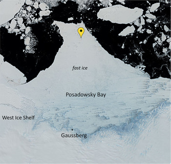
On leaving Heard Island, Captain Ruser set a southerly course, as one of the expedition’s objectives was to travel as far south as possible. Land was sighted on 21 February 1902, albeit entirely covered in ice (Drygalski, Reference Drygalski1904, p. 241). The expedition attempted to attain higher latitudes to the west of the ship’s position, but a row of colossal icebergs surrounded by pack ice hindered their progress. A snowstorm reduced the visibility to zero, and the following day, dense sea ice surrounded the ship. On 26 February 1902, the crew attempted to free the ship using all means available, including explosives, but their efforts were in vain. The Gauβ was beset at 66°02′S, 89°38′E for 50 weeks, and attempts to go farther south were thwarted. Despite valiant efforts to free the ship, on 2 March 1902, Drygalski realised that they had to prepare for a winter in the sea ice, and the ship was prepared as a winter station (Drygalski, Reference Drygalski1904, p. 254). He named the area of their winter activities Posadowsky Bay in honour of Count Posadowsky-Wehner, state secretary of the Interior Ministry, whose personal initiative had been central to obtaining the funds for the expedition (Fig. 1).
Posadowsky Bay, East Antarctica, and the wintering location of the Gauβ in 1902. (Image: Sentinel-2, Sentinel Hub EO Browser).

Already during the voyage south, the scientists had collected data and samples. As soon as the ship left Kiel, Ernst Vanhöffen, the expedition’s zoologist and botanist, commenced with observations of birds carefully recording their names, numbers and locations (Vanhöffen, Reference Vanhöffen1905). Whenever possible, he collected specimens that were prepared and described. The scientists and crew on board the Gauβ worked together and continued to carry out a comprehensive research programme in the ensuing months. The scientific output of this expedition was significant: Drygalski and his colleagues published 20 volumes of which volumes 9–20 were dedicated to zoology. Amongst the thousands of samples collected were 1,470 new species (Lüdecke, Reference Lüdecke, Fütterer, Damaske, Kleinschmidt, Miller and Tessensohn2006).
In January 1903, the men worked again hard to free their ship with explosives and ice saws. Eventually, the ship was released of the 5–6 m thick ice that had held her in place all winter, and they drifted with the pack ice. Prepared to spend the second winter in the ice, Drygalski hoped either to find another suitable wintering position or to continue the westwards drift until the next summer. On two occasions, the men thought to have found a location where the ship could safely be frozen in the ice, but both times, the sea ice loosened setting the ship adrift. In early April 1903, Drygalski considered his options and realised that the region they had entered would only allow them to spend the next winter on a drifting vessel. When during a stormy night on 8 April 1903, they barely escaped a collision with a massive iceberg, Drygalski saw no alternative to trying to leave the ice zone and heading north (Drygalski, Reference Drygalski1904, pp. 540–541). While travelling via St. Paul’s and Amsterdam islands, the Cape Colony (South Africa), St. Helena, Ascension Island and the Azores, the expedition members continued their research until they finally returned to Kiel on 24 November 1903 (Drygalski, Reference Drygalski1904, p. 658).
Emperor penguins as resource
The German expedition was prepared well, carrying supplies for nearly three years. Stores included some 20,000 kg of meat and sausages of 80 different varieties (Lüdecke, Reference Lüdecke2015, p. 32). Initially, pigs were a source of fresh meat, but naturally did not last beyond the early part of the ship’s journey. The majority of the expeditioners’ meat supply comprised every conceivable kind of canned meat. After a few months, the conserves had lost much of their flavour and taste, and it was difficult to discriminate pork from beef or chicken. The most distinguishing characteristic was the brand rather than the cans’ content, so that the men were inclined to ask the steward after the company’s name rather than the type of meat that had been prepared (Drygalski, Reference Drygalski1904, p. 376).
As characteristic for expeditions of the era, penguins and seals provided additional sustenance. Despite some initial resistance amongst the mainly German crewmembers to consume seal and penguin meat, the men supplemented their food provisions with fresh meat whenever possible, and consumed emperor penguins “very frequently” (Drygalski, Reference Drygalski1904, p. 377). During spring sledging trips, the men also often captured emperor penguins emerging from tide cracks (Drygalski, Reference Drygalski1904, p. 400). The expedition doctor, Hans Gazert, noted that due to the supplementation of their food stores with seals and penguins, the demand on their stores was less than the estimated 600 g meat per man per day (Drygalski, Reference Drygalski1904, p. 257).
For the maintenance of the dogs, large quantities of “stockfish” (dried cod) had been packed, but the supply was also augmented with seal and penguin meat. In contrast to some members of the crew, the dogs preferred to consume fresh meat. When the ship was prepared for the winter, the men deposited large quantities of supplies on the sea ice next to the ship. However, the frequent storms quickly buried the supplies, including much of the dried cod that reappeared only in summer when the snow melted (Drygalski, Reference Drygalski1904, p. 378).
During sledging trips, feeding the dogs could prove challenging. During the second trip in May 1902, extreme storms made travel impossible for days on end; hence, the trip lasted longer than planned. The fish rations for the dogs ran out days before the team returned to their winter quarters. Already while exploring the Gauβberg, a volcano ˜ 80 km south of the ship, fish supplies ran short, and the dogs received only half their usual portions. Since penguins and seals did not occur at the coast, the dogs — allowed to roam freely — caught petrels on the hill (Drygalski, Reference Drygalski1904, p. 308).
Shortly after the ship was beset, Drygalski described the menagerie of animals kept on board the ship (Drygalski, Reference Drygalski1904, p. 280). The emperor penguins amongst them received amphipods and squid to keep them alive. However, this process was successful only for a short time. Drygalski did not elaborate on why the feeding failed nor did he mention what happened to the penguins. In all likelihood, either the men or the dogs consumed these birds.
Several times in his account of the expedition, Drygaski commented on the beauty of emperor penguins, and expressed his disappointment that he and his men were not always able to control the pack of huskies. When penguins passed the ship, the dogs were difficult to contain and often broke free and mauled and killed many (Drygalski, Reference Drygalski1904, pp. 269–270). Some dogs ran off never to return. If they survived for any length of time, they probably hunted emperors throughout winter until the ice broke out.
Emperor penguins did not only supplement the expedition’s food supply, they also had a “technical use” (Drygalski, Reference Drygalski1904, p. 257). For the men’s survival, fuel was vital, and Drygalski carefully monitored its use. The steam engine of the Gauβ consumed coal that also fuelled the ships’ pump and electricity generator. When sailing through ice, the ship used 1.3 t per day compared to an average of 985 kg when lying in the ice. In March, Drygalski estimated that they could burn only a further 155 t to ensure sufficient supplies for their return, the timing of which of course was uncertain (Drygalski, Reference Drygalski1904, p. 257). Burning ˜900 kg coal per day would have provided the expedition with energy only for about another 22 weeks, until early August 1902. The men needed to reduce the coal usage and did so, for example, by no longer heating the cabins, and by using paraffin oil lamps rather than electricity. When the supply of paraffin started to run low, they constructed a wind generator, but the inability to regulate the current made it necessary to find an alternative.
On the ice near the ship, the crew had already established a boiler and herded passing penguins towards the vessel and into the boiler shed. Drygalski described how particularly the stoker Emil Berglöf shepherded the penguins to “his beloved boilers” in the boiler room (Drygalski, Reference Drygalski1904, p. 49). Attempts to keep emperor penguins in captivity failed mainly because the incessant snowstorms filled up the coral the men had constructed, and the penguins managed to escape. The men also killed Weddell seals Leptonychotse weddellii for both food and fuel; 10 kg seal fat produced about 8.5 kg usable oil (Drygalski, Reference Drygalski1904, p. 382).
Despite all the care taken to record measurements and catalogue samples, there appears to be no published evidence that the men kept track of the number of seals and penguins killed for food or fuel. Equally, apparently nobody recorded the constantly changing numbers of dogs or, if they did, Drygalski may not have considered this information important enough to be included in his publications. The Archiv für Länderkunde (archive for regional geography) in Leipzig, Germany, retains fourteen unpublished notebooks of Drygalski’s (Rack, Reference Rack2010) where the author recorded many details of daily life, and perhaps these journals contain the missing information. However, in general, the day-to-day activities appeared to be considered quite separate from the scientific endeavours.
Since no data exist, it is impossible to estimate the number of emperor penguins consumed by expedition members and dogs in 1902, but one may assume that the losses sustained by their population were substantial. Drygalski only made a vague reference to the numbers of birds seen or taken. For example, he described that emperor penguins passed the ship in large numbers in April, in several groups of more than 200 (Drygalski, Reference Drygalski1904, p. 281). He also mentioned that the men often ate these animals, and made trips specifically to collected penguins that appeared near the ship in “large herds” in “large quantities” for the dogs (Drygalski, Reference Drygalski1904, p. 470). The dogs apparently preferred the fresh meat to the dried fish, and took every opportunity to tackle the penguins. The only occasion when Drygalski mentioned actual counts of emperor penguins was in early December 1902, when chief engineer Stehr reported two groups of emperors (Drygalski, Reference Drygalski1904, p. 450). Since Stehr had encountered the emperor penguins towards the end of the breeding season, the penguins present were most likely only a fraction of the entire colony.
Is there an extant emperor penguin colony in Posadowsky Bay?
On 26 February, Drygalski noted the first emperor penguin in his account, and remarked that from this day on emperor penguins, “apparently clueless about men and dogs” (Drygalski, Reference Drygalski1904, p. 249), were their constant companions. Emperor penguins passed the ship frequently, at times in large numbers (>200). In the spring of 1902, the men occasionally saw chicks during their outings, but Drygalski lamented that they could never confirm a breeding colony (Drygalski, Reference Drygalski1904, p. 451). He may have based this conclusion on the observations by chief engineer Stehr. On 5 December 1902, Stehr had returned from an outing with an emperor penguin chick he had captured about 10 km south of the ship (estimated roughly at 66°07′S, 89°37′E). Here, he had also found a large number of emperor penguins. On 5 December 1902, Stehr brought one down-covered emperor penguin to the ship, and reported having sighted two “swarms” of penguins comprising 125 chicks plus 25 adults, and 30 chicks plus 10 adults, respectively (Drygalski, Reference Drygalski1904, p. 450). Yet, he considered himself unable to confirm conclusively that the location was a breeding colony, because he found neither eggs nor remains of shells. In the early19th century, the biology of emperor penguins was virtually unknown. Thus, the men could not have known that eggs, shells and even small chicks tend to disappear with time due to snowfall or trampling. Furthermore, emperor penguin colonies are quite mobile and can move several kilometres in a season. Drygalski speculated that since the chick captured by Stehr, and others found some days later, were too small to have traversed the large distance from the continent, the penguins either bred on the ice or on a nearby, undiscovered island (Drygalski, Reference Drygalski1904, pp. 451–452). Estimating the travel speed of the penguins and the age of the chicks, Vanhöffen (Reference Vanhöffen1905) also suspected the sea ice to be their breeding habitat. However, he did not appear to have been inclined to set out and explore this option himself. In the early 19th century, zoological studies focused largely on the collection and classification of specimens rather than their biology (Lüdecke, Reference Lüdecke1995, p. 77).
Thus, in 1902, a colony clearly existed. It has been elusive for many decades, perhaps because the German expedition did not provide the coordinates of the penguin aggregation. In 1956, members of the First Soviet Antarctic Expedition explored the southern area of Posadowsky Bay from the air but failed to locate a colony. The following Soviet expedition was also unsuccessful, but members of the Third Soviet Antarctic Expedition reported seeing a colony once from the air. Unfortunately, they did not publish the coordinates. On 21 June 1960, after several failed attempts, members of the Fifth Soviet Antarctic Expedition spotted emperor penguins amongst a group of icebergs but were unable to land (Korotkevich, Reference Korotkevich1964). On 22 August 1960, they reached the colony at 66°13′S, 89°35′E, ˜ 23 km S of the Gauβ winter location, and estimated approximately 2,500–3,000 adult emperor penguins occupying the site (Nudel’Man, Reference Nudel’Man1962, p. 49). There are no details about how the Russians derived this estimate or whether the estimate was made from the air or on the ground. August 1960 was probably the last time anyone saw the colony in situ, and since no further observations verified its presence in Posadowsky Bay, its existence was considered unconfirmed (Wienecke, Reference Wienecke2009).
In recent years, the first continent-wide survey of emperor penguin colonies using satellite imagery (Fretwell et al., Reference Fretwell, LaRue, Morin, Kooyman, Wienecke, Ratcliffe, Fox, Fleming, Porter and Trathan2012) did not detect a colony in Posadowsky Bay. A few years later, LaRue, Kooyman, Lynch & Fretwell (Reference LaRue, Kooyman, Lynch and Fretwell2015) reported a colony at the “Burton Ice Shelf” in East Antarctica, but did not provide any coordinates. Fretwell and Trathan (Reference Fretwell and Trathan2020) published the most recent record of known emperor penguin colonies, and included coordinates of an emperor penguin colony at the “Burton Ice Shelf”, recorded as a newly discovered colony in 2014. The authors were probably unaware of the history of emperor penguin observations in Posadowsky Bay, and did not realise that this colony has existed for decades. The coordinates provided by the Russians in 1960 were published by Woehler (Reference Woehler1993, p. 7) who listed the location as “Gaussberg”. The colony position recorded by Fretwell and Trathan (Reference Fretwell and Trathan2020) was only ˜ 7.8 km NW of the position recorded in 1960. Careful examination of the available satellite imagery supports the notion that there is only one colony in Posadowsky Bay albeit a rather mobile one.
To confirm the status of this colony, I applied the same method as Fretwell and Trathan (Reference Fretwell and Trathan2020), but used the 1:10,000 (100 m) scale rather than 1:50,000 (500 m). I examined Sentinel-2 images of Posadowsky Bay in the European Space Agency’s Sentinel Playground (https://www.sentinelhub.com/explore/sentinel-playground) from 2018 to 2020, and focused on the area 10–15 km south of the winter position of the Gauβ in 1902.
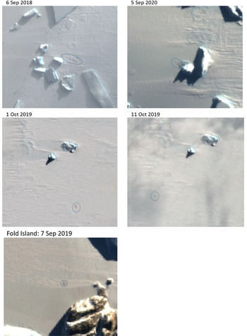
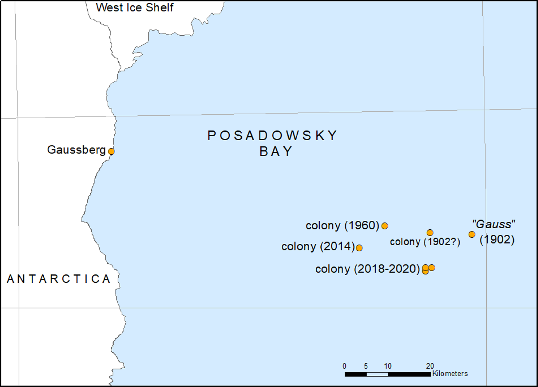
A small colony still exists, but finding it offered several challenges. Of the 48 Sentinel-2 images taken from 9 April 2018 until 4 December 2020 (excluding the period April to August each year when the area is in darkness and satellite images are not available in the visible range), 28 show the area covered by dense cloud. This is reminiscent of the constant, atrocious storms the men experienced in 1902 (Drygalski, Reference Drygalski1904). Nine clear images were taken either in the austral summer when the penguins no longer occupy their colony or in autumn just as the ice started to reform. Since 2018, only five images proved useful for the detection of a colony. In 2018, two images (6 September and 25 December) show faint stains about 500 m apart; in the images from 1 to 11 October 2019, some stained ice is recognisable less than 1 km apart. In the 2020 season, only one image clearly showed the typical discolouration of the fast ice (5 September) (Fig. 2). During the breeding season, emperor penguins are constantly on the move, and once the chicks are thermally independent, colonies spread out. This makes an accumulation of guano stains less likely. Also, heavy snowfall can cover the guano at any time during the breeding season. Furthermore, in spring, the sea ice starts to discolour making it difficult to distinguish guano from ice algae on satellite images. This is particularly an issue with very small colonies such as this. All locations were in the same small area (see Fig. 3) and ˜10 km SSE from the position of the Gauβ in 1902.
Faecal stains indicating the presence of emperor penguins in Posadowsky Bay. An image of the extant Fold Island colony is included for comparison. In September 2018, about 500 adults were present at Fold Island (based on ground images taken at the colony). (Images: Sentinel-2, Sentinel Hub EO Browser).

Locations where emperor penguins were reported. The sightings in 2014 and 2018–2020 are based on satellite imagery (2014 position from Fretwell and Trathan (Reference Fretwell and Trathan2020)). The yellow marker indicates the wintering position of the Gauβ in 1902.

Thus, the colony encountered in 1902, or at least a remnant of it, still exists. Members of the German expedition discovered the colony quite late in the breeding season, and we do not know whether the two groups they saw made up the entire colony. Given early observations by Drygalski of large groups of ˜ 200 emperors passing the ship, the presence of only 155 chicks in early December is either indicative of an unsuccessful breeding season, or a sign of the significant impact of the utilisation of the penguins by the expedition.
Conclusions
When the German expedition got underway, whaling companies had already depleted northern hemisphere stocks to a point of commercial unviability, and had started to look for new hunting grounds in the Southern Ocean. Yet, there appeared to be little awareness of the significant impact human activities had on exploited wildlife populations.
With regard to the German expedition, contemplating the careful usage of the expedition’s provisions demonstrates that “resource management” was well understood and practised. However, it appears to have been limited to the resources on the ship. Once the men’s fate was sealed and the ship was beset, all provisions (final resources) were divided into two monthly lots of 50–60 boxes to avoid overconsumption. The steward also strictly rationed supplies, and Drygalski and Gazert kept a book of fuel usage and reserves. This careful management did not apply to natural resources described by Drygalski as “inexhaustible” (Drygalski, Reference Drygalski1904, p. 382).
From a scientific view, research fields such as population dynamics did not yet exist. As early as the 12th century, zoology started to develop as an area of scientific endeavour, but entailed mainly the collection and classification of animals, and the study of their anatomy. In the late 19th and early 20th centuries, little seemed to have changed. A huge number of specimens, mainly invertebrates but also fish and birds, were collected and prepared for the voyage home, and carefully documented by Vanhöffen. His scientific interest in penguins (and seals) appeared to be limited to the determination of blood temperatures and concentrations, as well as freezing points (Drygalski, Reference Drygalski1904, p. 365).
The most recent rough estimate of the size of the colony in Posadowsky Bay dates back to August 1960 (Nudel’Man, Reference Nudel’Man1962, p. 49), a time when the females would have returned to the colony increasing the number of individuals present. Comparison of the size of the stains in Posadowsky Bay to those of a small colony of < 1,000 breeding pairs at Fold Island (−67.32°S, 59.32°E; pers. obs.) shows that the stains visible in the recent Sentinel-2 images of the colony are about the same size as at Fold Island (Fig. 3). The colony in Posadowsky Bay may now be no larger than the colony that used to exist at the Dion Islands where about 180 pairs were found in the 1950s (Stonehouse, Reference Stonehouse1953).
The presence of the German expedition was undoubtedly not the sole reason for the apparently dramatic decrease in the size of the colony in Posadowsky Bay, but it was probably fortuitous that the expedition did not spend the second winter there. Disastrous seasons with low or zero breeding success occur (e.g. Barbraud & Weimerskirch, Reference Barbraud and Weimerskirch2001; Robertson, Wienecke, Emmerson & Fraser, Reference Robertson, Wienecke, Emmerson and Fraser2014), as does occasional mass mortality amongst adults (Cape Crozier) (Kooyman, Ainley, Ballard & Ponganis, Reference Kooyman, Ainley, Ballard and Ponganis2007). Given enough time, local populations can rebound (Barbraud et al., Reference Barbraud, Gavrilo, Mizin and Weimerskirch2011), but very small colonies are at risk of not recovering (Trathan et al., Reference Trathan, Fretwell and Stonehouse2011). After having survived an unprecedented assault, the colony has survived for another 120 years. It remains to be seen for how much longer this colony will be able to survive.
Finally, I offer some thoughts on the naming of the colony. There are no rules on how to name emperor penguin colonies. It appears straightforward when a colony is situated near a distinct geographical feature, such as an island or islands (e.g. Fold Island, Beaufort Island or Brownson Islands), or peninsulas or capes (e.g. Bear Peninsula, Jason Peninsula, Cape Washington, Cape Crozier). All these colonies are located near the coast, and naming them after prominent geographic features is sensible. It is a different matter when a colony is tens of kilometres north of the coast. Then naming it after a local underwater feature seems appropriate (e.g. Ninnis Bank, Petersen Bank). Several colonies have simply been named after the bay in which they occur (e.g. Atka Bay, Halley Bay, Amanda Bay). With regard to the colony of interest here, it seems most fitting to name it after the bay where it is located, Posadowsky Bay. Based on the sightings made over the decades, the colony is about 58–73 km north of the Gaussberg, and there are no known significant underwater features or islands nearby (Drygalski Island is about 120 km east). To call it “Burton Ice Shelf” colony (see Fretwell & Trathan Reference Fretwell and Trathan2020) is problematic as there is no ice shelf by this name. The feature referred to by Fretwell and Trathan (Reference Fretwell and Trathan2020) probably is the Burton Island Glacier, a small glacier named for the US navy vessel USCGC Burton Island that participated in the first Antarctic Development Program of the United States (known as Operation Highjump) in Antarctica in 1946–1947 (http://www/uscg.mil/history/webcutters/Burton_Island_1966.asp). This glacier is about as far away from the known colony location as the Gaussberg. Over the years, this colony has occupied several tens of kilometres and is a long way from the coast; the logical conclusion is to call it the Posadowsky Bay colony.
Acknowledgements
This work was carried out as part of the Australian Antarctic Division’s AAP Project 4564. I thank our librarian Tess Egan for delivering the needed references always in a timely manner. I also thank the two anonymous referees for their valuable comments and suggestions.
Financial support
This work is part of AAD Project 4564 and was supported by the Australian Antarctic Division. The manuscript was prepared by the author alone. The ethical standards of publishing were adhered to.
Conflict of interest
The author declares no conflict of interest.