1. Introduction
The Aegean region is one of the most active extensional regions in the world and is undergoing a N–S extension (Dewey & Şengör, Reference Dewey and Şengör1979). The western Anatolian horst graben system forms the eastern boundary of the Aegean extensional system.
There is no still consensus on the ongoing debates related to the prevailing extension in western Anatolia. In recent years, two major problems have been associated with the geology of the graben regions and the related structures. (1) What are origins of the graben? Mainly, four groups of different models have been proposed to answer this question: (a) the back-arc spreading model (McKenzie, Reference McKenzie1978; LePichon & Angelier, Reference LePichon and Angelier1979; Jackson & McKenzie, Reference Jackson and McKenzie1988; Kissel & Laj, Reference Kissel and Laj1988; Meulenkamp et al. Reference Meulenkamp, Wortel, Van Wamel, Spakman and Hoogerduyn Strating1988; Thomson, Stöckhert & Brix, Reference Thomson, Stöckhert and Brix1998; Avigad et al. Reference Avigad, Garfunkel, Jolivet and Azanòn1997; Jolivet et al. Reference Jolivet, Faccenna, Goffe, Mattei, Rossetti, Brunet, Storti, Funiciello, Cadet, D'Agostino and Parra1998); (b) the orogenic-collapse model (Dewey, Reference Dewey1988; Seyitoğlu & Scott, Reference Seyıtoğlu and Scott1991, Reference Seyıtoğlu and Scott1992, Reference Seyıtoğlu and Scott1996; McClusky et al. Reference McClusky, Balassania, Barka, Demır, Ergıntav, Georgiev, Gürkan, Hamburger, Hurst, Kalhe, Kastens, Kekelidze, King, Kotzev, Lenk, Mahmoud, Mishin, Adariya, Ouzounis, Paradissis, Peter, Prilepin, Reilinger, Sanli, Seeger, Tealeb, Toksöz and Veis2000); (c) the tectonic-escape model (Dewey & Şengör, Reference Dewey and Şengör1979; Şengör, Görür & Şaroğlu, Reference Şengör, Görür, Şaroğlu, Biddle and Christie-Blick1985; Şengör, Reference Şengör, Coward, Dewey and Hancock1987) and (d) the two-stage graben model (orogenic collapse/roll-back and tectonic escape) (Koçyiğit, Yusufoğlu & Bozkurt, Reference Koçyığıt, Yusufoğlu and Bozkurt1999; Westaway, Reference Westaway2003; Bozkurt, Reference Bozkurt, Bozkurt, Winchester and Piper2000, Reference Bozkurt2001, Reference Bozkurt2003, Reference Bozkurt2004; Yılmaz et al. Reference Yilmaz, Genç, Gürer, Bozcu, Yilmaz, Karacik, Altunkaynak, Elmas, Bozkurt, Winchester and Piper2000; Cihan, Saraç & Gökçe, Reference Cıhan, Saraç and Gökçe2003; Purvis & Robertson, Reference Purvis and Robertson2004, Reference Purvis and Robertson2005; Bozkurt & Rojay, Reference Bozkurt and Rojay2005). (2) Is the extension in the region continuous? (a) According to some workers, extensional forces continuously operated from the latest Oligocene–Early Miocene to Quaternary times (Seyitoğlu & Scott, Reference Seyıtoğlu and Scott1991; Seyitoglu, Scott & Rundle, 1992; Seyitoğlu et al. Reference Seyıtoğlu, Çemen and Tekelı2002; Işık, Seyitoğlu & Çemen, Reference Işik, Seyıtoğlu and Çemen2003). (b) Some other workers proposed a multi-stage extensional history with two different views. The first group of scientist believes that latest Oligocene–Early Miocene extension cannot be responsible for the entire history of extensional tectonics and that continental extension in the region is not a continuous event (Purvis & Robertson, Reference Purvis and Robertson2004, Reference Purvis and Robertson2005; Bozkurt & Sözbilir, Reference Bozkurt and Sözbılır2004; Bozkurt & Rojay, Reference Bozkurt and Rojay2005). However, according to this extensional model, in western Anatolia the extension direction has always been N–S. The second group proposes prolonged extensional histories or multiple episodes of extension (Altunkaynak & Yılmaz, Reference Altunkaynak and Yilmaz1998; Koçyiğit, Yusufoğlu & Bozkurt, Reference Koçyığıt, Yusufoğlu and Bozkurt1999; Karacık & Yılmaz, Reference Karacik and Yilmaz1998; Genç & Yılmaz, Reference Genç and Yilmaz2000; Yılmaz et al. Reference Yilmaz, Genç, Gürer, Bozcu, Yilmaz, Karacik, Altunkaynak, Elmas, Bozkurt, Winchester and Piper2000; Yılmaz & Karacık, Reference Yilmaz and Karacik2001; Genç et al. Reference Genç, Altunkaynak, Karacik, Yazman and Yilmaz2001; Gürer & Yılmaz, Reference Gürer and Yilmaz2002; Ring et al. Reference Ring, Johnson, Hetzel and Gessner2003; Ö. Gürer et al. Reference Gürer, Gürer, Pınçe and İlkişik2001; Gürer et al. Reference Gürer, Kaymakçi, Çakir and Özburan2003; Gürer, Sangu & Özburan, Reference Gürer, Sanğu and Özburan2006; Koçyiğit, Reference Koçyığıt2005; Kaymakçı, Reference Kaymakçi2006; Koçyiğit & Deveci, Reference Koçyığıt and Devecı2007).
The origin of continental extension and evolution, and even discussion of these matters, is inevitably speculative. On the other hand, hypotheses related to the continuity of the extension can be tested by detailed geological studies in the graben regions.
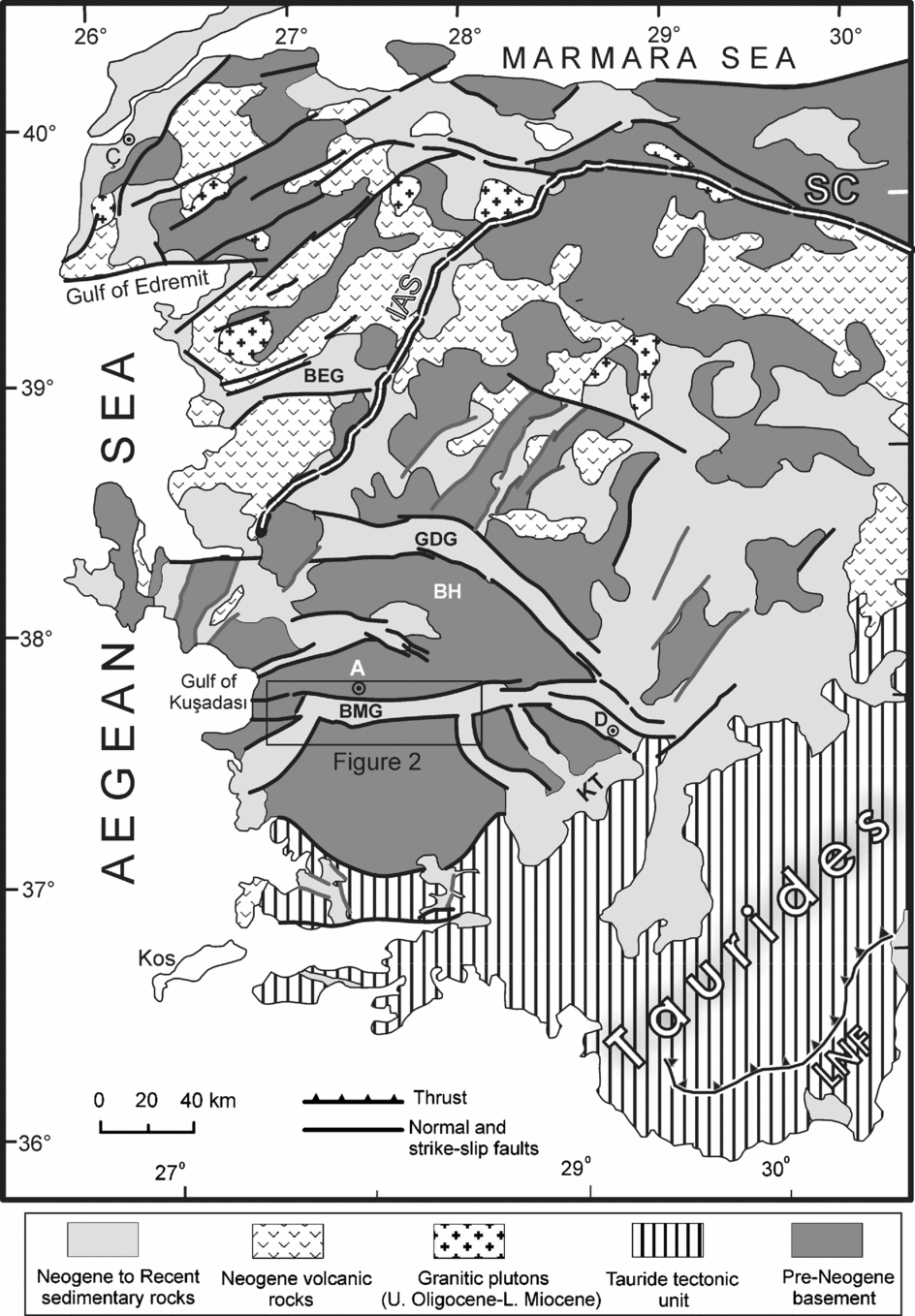
In the western Anatolian horst graben region, there are two main structural basins trending N and E (Fig. 1). Approximately N-trending basins are inactive, and their relationships with the E–W-trending basins are intensely debated. They are either thought to be irrelevant to the present-day N–S extension (Angelier et al. Reference Angelier, Dumont, Karamanderesi, Poisson, Şimşek and Uysal1981; Yılmaz et al. Reference Yilmaz, Genç, Gürer, Bozcu, Yilmaz, Karacik, Altunkaynak, Elmas, Bozkurt, Winchester and Piper2000) or to mark the beginning of the extension (Seyitoğlu & Scott, Reference Seyıtoğlu and Scott1991, Reference Seyıtoğlu and Scott1992; Bozkurt, Reference Bozkurt, Bozkurt, Winchester and Piper2000, Reference Bozkurt2003). The E–W-trending basins, Büyük Menderes and Gediz graben being the most prominent ones, form the major set in the region and are still active. They reflect the stress field of the prevailing N–S extension in western Anatolia.
Geological map of western Anatolia. SC – Sakarya Continent, IAS – İzmir–Ankara Suture, BEG – Bergama Graben, GDG – Gediz Graben, BH – Bozdağ Horst, BMG – Büyük Menderes Graben, KT – Kale–Tavas Basin, LNF – Lycian Nappe front. A, Ç and D are cities of Aydın, Çanakkale and Denizli, respectively (modified from Yılmaz et al. Reference Yilmaz, Genç, Gürer, Bozcu, Yilmaz, Karacik, Altunkaynak, Elmas, Bozkurt, Winchester and Piper2000).

The Büyük Menderes Graben characterized by Miocene–Quaternary terrestrial sediments, now uplifted and deeply incised, provides excellent exposure to study sedimentation and extensional tectonics. Numerous studies have been conducted in the Büyük Menderes Graben region. They can be grouped as regional (Şengör, Reference Şengör, Coward, Dewey and Hancock1987; Şengör, Görür & Şaroğlu, Reference Şengör, Görür, Şaroğlu, Biddle and Christie-Blick1985; Yılmaz et al. Reference Yilmaz, Genç, Gürer, Bozcu, Yilmaz, Karacik, Altunkaynak, Elmas, Bozkurt, Winchester and Piper2000; Seyitoğlu, Işık & Çemen, 2004; Bozkurt & Mittwede, Reference Bozkurt and Mittwede2005), tectonic (Seyitoğlu & Scott, Reference Seyıtoğlu and Scott1991, Reference Seyıtoğlu and Scott1992; Emre & Sözbilir, Reference Emre and Sözbılır1997; Altunel, Reference Altunel1999; Bozkurt, Reference Bozkurt, Bozkurt, Winchester and Piper2000; Ö. Gürer et al. Reference Gürer, Bozcu, Yilmaz and Yilmaz2001; Koçyiğit, Reference Koçyığıt2005; Kaymakçı, Reference Kaymakçi2006), biostratigraphic (Ünay et al. Reference Ünay, Göktaş, Hakyemez and Şan1995; Ünay & De Brujin, Reference Ünay and De Bruijn1998; Akgün & Akyol, Reference Akgün and Akyol1999; Sarıca, Reference Sarica2000; N. Sarıca-Filoreau, unpub. Doct. thesis, Muséum National D'Historie Naturelle, Paris, 2002), stratigraphic and sedimentological (Cohen et al. Reference Cohen, Dart, Akyüz and Barka1995) and geophysical (Sarı & Şalk, 2006; Westaway, Reference Westaway2006).
However, a detailed geological mapping project in the Büyük Menderes Graben, which is the largest graben of the western Anatolian graben system, has been lacking. The objective of this paper is to present and interpret new stratigraphic and structural data gathered by the detailed geological mapping project which lasted two years and produced more than 20 sheets for the Büyük Menderes Graben region. The detailed study of the thick sequence of fluvial and lacustrine sediments and analysis of the related structures between the Aydın and Menteşe mountains, presented in this paper, allows us to revise the timing and style of faulting that controlled sedimentation in the Büyük Menderes Graben region. The results of our field study, as well as published data in terms of tectonics, stratigraphy and sedimentology, are synthesized to explain the development of the Büyük Menderes Graben.
2. Geological characteristics
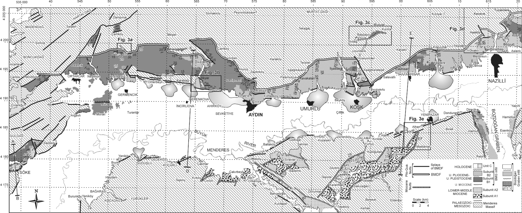
The Büyük Menderes Graben is bounded to the north and to the south by the Menderes Massif metamorphic rocks (Figs 1–3). It is ~ 140 km long and 2.5–14 km wide, and forms an arc-shaped structural pattern. The graben trends approximately E–W to Ortaklar. From Ortaklar westward the trend changes drastically to the SW. The width of the graben increases from the east to the west. The northern margin of the graben is bounded by the linear mountain front of Aydın Mountain, rising steeply from 50 m to over 1750 m, whereas the southern margin has a more subdued topography. This morphology suggests that the Büyük Menderes Graben is an asymmetric graben.
(a) Geological map of the Büyük Menderes Graben. BMDF – Büyük Menderes Detachment Fault, EF – Eğridere fault, ZF – Zeytinli fault, SF – Sıralılar fault. Small letters indicate the locations of the enlarged maps shown in Figure 3. A–B, C–D and E–F represent the lines of cross-sections given in Figure 4.

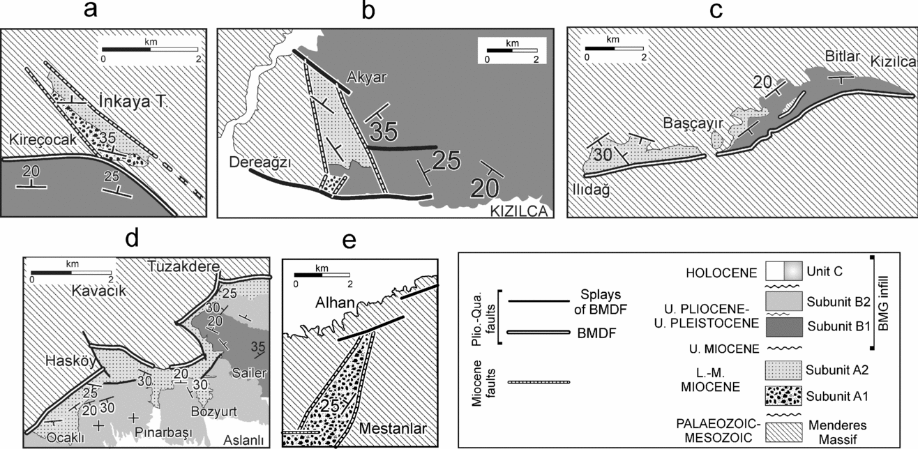
Enlarged geological maps from Figure 2, showing the cross-cutting relationships between NW- and NE-trending faults, and E-trending faults, and discordant relationships between Unit A and Unit B. (a) Northern Hıdırbeyli area, (b) Kızılca area, (c) Başçayır area, (d) Sailer area, (e) Alhan area.

Two major rock groups are distinguished in the Büyük Menderes Graben and surroundings: pre-Neogene basement and Neogene–Quaternary sedimentary cover (Figs 4, 5), up to 2.5 km thick. Detailed descriptions of the basement units are outside the scope of this paper. The main emphasis is given to the Neogene–Quaternary cover units and their relationships with the current structural grain of the region.
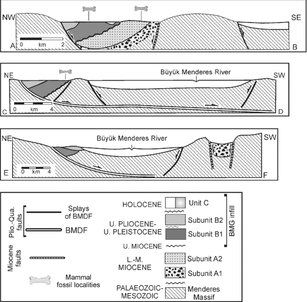
Geological cross-sections (lines of cross-sections are shown in Fig. 2).

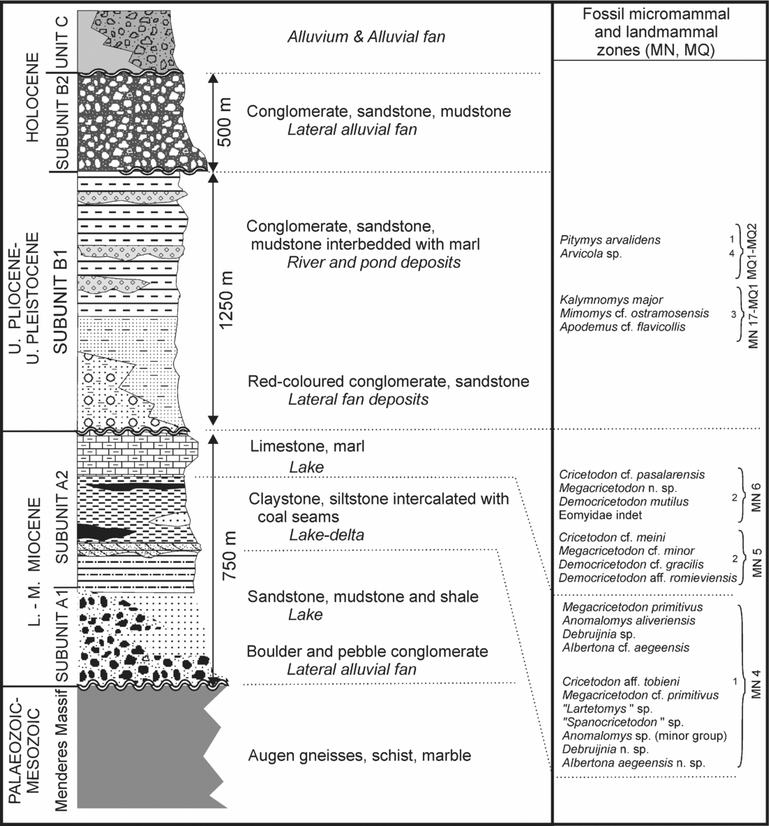
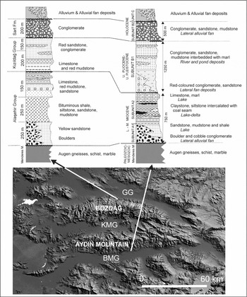
Generalized stratigraphic columnar section of the Büyük Menderes Graben. Numbers show references of some selected micromammal fossil localities. 1 – Söke, Dededağ, (Söke), Kemalpaşa Mahallesi II (Söke): Ünay & Göktaş, Reference Seyıtoğlu and Scott1999; 2 – Çakaltepe, Gerişdağ (Söke); N. Sarıca-Filoreau, unpub. Doct. thesis, Muséum National D'Historie Naturelle, Paris, 2002; 3 – Kartaltepe I (Söke), İkizdere (Aydın); Sarıca, Reference Sarica2000; 4 – Moralı II (Germencik); Ünay et al. Reference Ünay, Göktaş, Hakyemez and Şan1995.

2.a. Basement
The pre-Neogene basement in the central part of western Turkey consists mainly of Proterozoic–Mesozoic highly metamorphic rocks, known as the Menderes Massif. This Massif forms a broad dome, composed mainly of Precambrian and Tertiary granites and Tertiary mylonitic gneiss. The stratigraphy of the massif has been considered to consist of two major rock associations: the ‘core’ and the ‘cover’ of the massif (Schuiling, Reference Schuiling1962). The core rocks are composed of augen gneisses, metagranites, schists, paragneisses and metagabbros (Satır & Friedrichsen, Reference Satir and Friedrichsen1986; Candan, Reference Candan1995). The cover rocks comprise schist and marble. While the core is considered Precambrian in age, the cover is dated as Palaeozoic to Early Tertiary. The central part of the massif has attained its present morpho-tectonic position as a metamorphic core complex by domal uplift through detachment faults (Bozkurt & Park, Reference Bozkurt and Park1994; Lips et al. Reference Lips, Cassard, Sözbılır, Yilmaz and Wijbrans2001; Gessner et al. Reference Gessner, Ring, Christopher, Hetzel, Passchier and Güngör2001; Işık & Tekeli, Reference Işik and Tekelı2001; Okay & Satır, Reference Okay and Satir2000; Seyitoğlu, Işık & Çemen, Reference Seyıtoğlu, Işik and Çemen2004; Glodny & Hetzel, Reference Glodny and Hetzel2007).
2.b. The cover units
Sedimentary rocks in the Büyük Menderes Graben region underwent Neogene–Quaternary crustal deformation during the development and evolution of the horst and graben zone. The interpretation of the data from the cover units of the western part of the Büyük Menderes Graben region reveals the presence of three lithostratigraphic units, termed A, B and C (Figs 2–5). Of these three units, Unit A and Unit C are exposed on the southern margin, while all three are exposed on northern margin. All of the units display depositional as well as tectonic contact with the basement metamorphic rocks.
2.b.1. Unit A
Unit A can be subdivided into the Lower subunit (A1), 50–500 m thick, and Upper subunit (A2), 50–300 m thick. The two subunits consist of heterolithic breccia, conglomerate, sandstone, mudstone, marl and coal beds deposited in a shallow-water environment. Rocks of Unit A crop out both to the north and south of the Büyük Menderes Graben, but can only be clearly distinguished in the south. Unit A is exposed on the structural highs of the Büyük Menderes Graben. Its deposits are scattered along the northern margin and delimited by NNW- and NW-trending faults (Fig. 3a, b). In the north, at the base of subunit A1 there is a polygenic, 50–500 m thick, clast-supported conglomerate, cobble to boulder in size and angular to subrounded. The beddings laterally grade into massive rock. The matrix is moderately to very poorly sorted, fine- to coarse-grained sandstone. Above the conglomerates, this subunit passes upward into inter-fingering sandstone, mudstone, shale and marls; locally they contain thin coal seams (subunit A2). Sandstones are well bedded, well sorted, and comprise poorly rounded metamorphic clasts embedded within muddy matrix. Lateral and vertical transitions from one lithology to another are very common throughout this sequence, which is also characterized by numerous scour-and-fill structures filled with channel conglomerates. The sandstones contain alternating lignite beds (~ 5–15 cm) and the shales are bituminous.
In the south, the typical lithology of subunit A1 is unconsolidated massive gravel with predominantly rounded to sub-rounded boulders and pebbles composed mostly of gneiss, together with schist and quartzite. The conglomerates have very extensive outcrops to the southern side of the Büyük Menderes Graben. The deposits predominantly show a chaotic internal fabric, although layers showing very crude clast alignment are present. In the Dalama area (south of the Büyük Menderes Graben), unit A is bounded by NE-trending oblique faults, to the west and east (Fig. 3e). Away from the fault zone the clast size decreases rapidly; the cobblestones pass laterally into a well-bedded sandstone–siltstone alternation, subunit A2. West of the Eğridere Fault, the gravel is poorly sorted, clast-supported towards the southeast and matrix-supported to the northwest. In places, local crude stratification and imbrications indicating traction currents are observed. Sandstone, siltstone, lignite, shale, mudstone and marl deposits are observed higher up in the succession. A varying range of fine-scale sandstone–mudstone alternations characterizes the facies. The sandstone is fine- to medium-grained and varies in thickness from a few millimetres to some 40 cm, and alternates with grey or dark carbonaceous shale of variable thickness. The siltstone and fine sandstone strata in the heterolithic units are characterized by a variety of sedimentary structures including parallel lamination, small lenticular beds and ripple laminations of different scales. The grey shales or carbonaceous mudstones are usually characterized by parallel laminations. Often the coal seams have been locally folded and faulted.
The boulder to cobble conglomerate of subunit A1 is interpreted as alluvial fan deposits. The absence of any internal organization and sorting indicates that these deposits were produced by mass-transport mechanisms. They may be interpreted as generated by subaerial gravity flows in the early stages of dry alluvial fans. It typically overlies crystalline basement rocks at the basin margin (Fig. 4, cross-section A–B) and is composed of locally derived clasts of gneissic lithologies, schist and marble. The lithological ordering indicates a rapid transition from a high-energy fluvial depositional environment to a low-energy lacustrine environment. Characteristics of the deposits as fault-scree, slope waste, debris flow and lateral fan deposits, and their occurrence along the steeply dipping faults indicates that they were sourced from fault-elevated blocks (subunit A1). Away from the faults towards the basin centre they grade into sandstones, siltstones, mudstones and marls of subunit A2. The coal-bearing subunit A2 can be interpreted as lacustrine facies which deposited in shallow, open freshwater lakes.
Unit A is dated as Late Early Miocene–Late Middle Miocene, based on the small mammal associations found in subunit A2 in the Söke region from five localities: Söke, Dededağ (MN 4: Ünay & Göktaş, Reference Seyıtoğlu and Scott1999), Sesa mine, Çakaltepe and Gerişdağ (MN 4, MN 5, MN 6: Sarıca, 2000; N. Sarıca-Filoreau, unpub. Doct. thesis, Muséum National D'Historie Naturelle, Paris, 2002; Fig. 5).
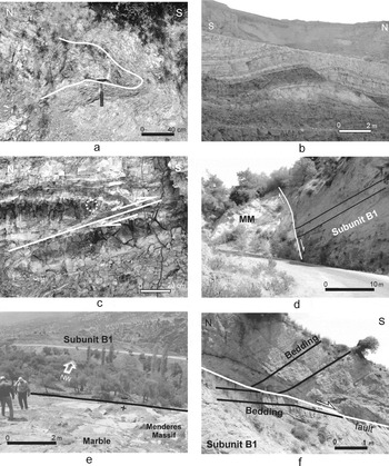
In the northern part of the Büyük Menderes Graben, this unit is deformed with approximately east–west-trending overturned (north of Nazilli, Fig. 6a) to open folds (Sıralılar, Fig. 6b) and reverse faults (Söke, Fig. 6c). These deformational structures cannot be mapped in 1:25 000 scale. Unit A is overlain by Unit B with an angular unconformity on a region-wide, low-relief erosional surface (Figs 2, 3b–d: Söke, Kızılca, Başçayır, Sailer).
(a) Overturned anticline in Unit A in north of Nazilli; (b) open anticline dissected by a normal fault in the Sıralılar coal mine; (c) thrust fault in Unit A in southwest of Söke; (d) Büyük Menderes Detachment Fault near Palamutcuk village. Clastics of Unit B are back-tilted to the north with low angle (~ 15°); (e) good exposure of the detachment fault near Kızılca village. Red clastics of Unit B are gently back-tilted (~ 20°) to the south; (f) syn-sedimentary faulting mainly developed during Unit B deposition. These listric faults dip S and trend E–W. Unit B deposits include a northward block rotation and internal angular unconformities.

2.b.2. Unit B
Unit B in and around the Büyük Menderes Graben is best exposed in a 2–10 km wide zone along its northern margin. It is approximately 1750 m thick and delimited in the north by the Büyük Menderes Detachment Fault. The succession is subdivided into two subunits: the first one (subunit B1) consists of conglomerates, sandstones, mudstone and marl; the second (subunit B2) is mainly conglomerate and sandstone.
Subunit B1 is composed mostly of fluvial orange-red conglomerates, grey to greenish grey sandstones and subordinate mudstones and marls, 1250 m thick. This clastic unit is poorly sorted and contains subrounded to subangular grains. Conglomerate deposits form 0.3–2 m thick lenticular beds that extend laterally 3 to 50 m. This subunit is clear and shows fining-upward character. Each complete cycle starts with a thick conglomerate or pebbly to coarse-grained sandstone at the base, successively followed by medium- and fine-grained sandstones and interbedded sandstone–mudstone, terminating with marl at the top. The subunit consists of trough to low-angle tabular cross-bedded, poorly sorted pebbly sandstone, and sandstone with common thin stringers of sandy pebble conglomerate. The coarse clastic rocks pass laterally and vertically into fine-grained sandstones and siltstones, which grade rapidly into mudstone and marl deposits. This facies is represented by moderately to poorly sorted, weakly laminated sandstone and mudstone containing peat in places.
Subunit B1 marks the beginning of major tectonic activity with large amounts of sedimentation to the north. This is evidenced by the constant supply of coarse clastic materials from the metamorphic massif into the structurally low-lying areas in front of it. The thick, coarse clastic rocks in the lower part of the succession were apparently formed in a high-energy depositional environment. This subunit comprises alternating sequences of both alluvial and fluvial conglomerates which are thickest towards the Aydın Mountain. In some places these fluvial deposits grade into pond and swamp deposits. The distribution of coarse-grained facies in these deposits suggests synchronous deposition with active faulting along the margins of the Büyük Menderes Graben which is related to the elevation of the Menderes Massif by a major normal fault. This fault is a major breakaway (detachment) fault and its present dip is 30–60° to the south. Above the fault plane, red clastics of Unit B1 are gently back-tilted (20–30°) to the north. The energy of the environment decreased gradually, as evidenced by the fining-upward profile recognized in the succession.
Subunit B1 rests either on Unit A with an angular unconformity or on the metamorphic rocks. It is overlain by subunit B2, either with disconformity or angular unconformity. The conglomerates of subunit B1 may show roll-over deformation near faults as a result of displacements along the faults. These sediments are uplifted along the footwall of the south-facing active normal faults with respect to the present-day graben floor.
Within the strip of the river-pond deposits, eleven small mammal localities have been studied, assigning a Latest Pliocene–Late Pleistocene age (that is, 1.8–0.4 Ma) to subunit B1 (Ünay et al. Reference Ünay, Göktaş, Hakyemez and Şan1995; Ünay & De Bruijn, Reference Ünay and De Bruijn1998; Sarıca, Reference Sarica2000; N. Sarıca-Filoreau, unpub. Doct. thesis, Muséum National D'Historie Naturelle, Paris, 2002). The oldest dating, 1.8 Ma, comes from the İkizdere small mammal locality. This locality is found in the lower part of subunit B1, which rests unconformably on the metamorphic rocks. The Moralı small mammal locality has been dated as Torringian (0.4 Ma). Another Late Pleistocene dating is obtained in the rocks of subunit B1 exposed in the modern graben valley. Subunit B1 is equivalent to units II and III of Cohen et al. (Reference Cohen, Dart, Akyüz and Barka1995).
Subunit B2 borders the graben floor along its northern margin, where it is uplifted by modern graben faults and forms steep linear hills. It is a regionally extensive unit of alluvial sedimentary rocks, approximately 500 m thick. This subunit is internally chaotic and exposed along the northern margin. It comprises approximately horizontal, massive, buff- to light yellow-coloured, poorly sorted, poorly bedded, semi-lithified cobble to pebble conglomerates with alternations of sandstone, siltstone and mudstone. Beds are tabular to broadly lenticular, 20–300 cm thick, weakly stratified, and locally display 10–30 cm thick basal erosional relief. Sandstone is weakly bedded, characterized by tabular to low-angle trough cross-bedding and includes rare thin discontinuous stringers of granule conglomerate and siltstone. Weak grading is also present. These rocks were apparently derived from the elevated fault blocks and deposited along the basin margin. The depositional features indicate a basin marginal, stream flow-dominated, alluvial fan environment. The alluvial fans were concentrated along the northern margin, and supplied sediment from the Menderes Massif crystalline basement rocks and exhumed older units. The pebbles show imbrication fabric dipping N 10–20°, suggesting a provenance from the north and deposition by fluvial streams.
Subunit B2 rests on the metamorphic rocks, Unit A and locally on subunit B1 with an unconformity. It is overlain unconformably by the present-day graben-floor deposits (unit C) and bounded either by the detachment fault or high-angle faults. The subunit is generally horizontally disposed but in some places back-tilted towards the north, at varying angles (10–30°), depending on proximity to the faults (Fig. 6d–f). The back-tilting is due to rotation of the S-dipping normal faults
There is no biochronological control for dating subunit B2. On the other hand, based on the superpositional relationships of the strata, the subunit should be younger than Toringian (0.4 Ma, youngest age data obtained for subunit B1) and older than the present-day graben-floor deposits. This subunit is equivalent to unit IV of Cohen et al. (Reference Cohen, Dart, Akyüz and Barka1995), the Sart formation of Seyitoğlu & Scott (1996), Asartepe formation of Koçyiğit, Yusufoğlu & Bozkurt (1999) and Sart group of Yılmaz et al. (2000).
The depositional and deformational features of Unit B, including fan-shaped geometries of deposits (thicker near the Büyük Menderes Detachment Fault), local truncation and erosion surfaces, back-tilting and folding of strata near faults, are considered to be related to the listric geometry of the Büyük Menderes Detachment Fault.
2.b.3. Unit C
The third sedimentary unit is the present infill of the Büyük Menderes Graben. The present graben-floor sediments developed by the active normal faults are represented by fan deposits and fluvial deposits. The most voluminous alluvial fans in the north of the Büyük Menderes Graben region have developed adjacent to the catchments uplifted by Holocene high-angle faults, implying that a young tectonic activity has exerted a first-order control on sediment accumulation rates along the range front. The alluvium was transported and deposited by numerous steep-gradient, high-energy, south-flowing streams that originate at altitudes above 1500 m within 50 m of the Büyük Menderes Graben basin, and they grade into fine-grained graben-floor sediments. The alluvial material was widely deposited as a series of fans, with the head of each fan probably at a stream channel incised into bedrock and some widening downstream to coalesce with neighbouring fans from adjacent channels. The downstream parts of the fans are located in the graben. They form broad alluvial plains that gently slope and thicken northward to the Büyük Menderes Graben. Unit C is either overlain unconformably or juxtaposed with units B1 and B2 along the graben margin-bounding high-angle normal faults (Fig. 2). The fan deposits are sourced from high hills bordering the east–west graben.
3. Structural geology
In the region, different tectonic processes during Neogene–Quaternary times produced a network of fault systems and several basins, filled by continental deposits. Distribution of thick alluvial and fluvial deposits and of clastic deposits indicates localized subsidence and strong vertical and horizontal movement, connected to the activity of basin-bounding master faults. This fault network is dominated by an array of faults with dominant E to NE and NW orientation (Fig. 2).
The study area is traversed by several sets of faults, varying from sub-vertical oblique slip faults to high- and low-angle normal faults. There is very limited evidence for pure normal slip displacement. The conjugate faults have strikes mainly in the NE and NW directions, whereas most of the normal slip fault trends east. We recognize two systems of faults: (1) approximately NE- and NW-trending subvertical oblique faults adjacent to Unit A; (2) E–W faults adjacent to units B and C. The second system can be subdivided into: (a) a major E-trending low-angle fault, the Büyük Menderes Detachment Fault, and (b) secondary listric high-angle faults, segmented for distances over 10 km.
The kinematics of a fault population were studied by measuring the striations on the fault planes at several sites. Measurements were taken on outcrops of fault scarps ranging from a few centimetres to several metres, often related to much larger inaccessible fault scarps. The measured fault scarps are usually characterized by smooth, polished surfaces with well-preserved slickensides and fibres. Slickenfibres are relatively common in marble surfaces of the Menderes Massif; when possible, they were used to determine sense of motion.
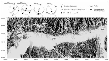
Fault kinematic analyses using the data from striated fault planes of low-angle normal faults and high-angle normal faults were performed in order to determine the kinematic framework of faulting during each of the inferred extensional episodes. The fault-slip data were collected from both sides of the Büyük Menderes Graben. Howver, the minimum number of slickenline data required to construct a stress tensor is 4 in the direct inversion method (Angelier, Reference Angelier1979); data from the southern side of the Büyük Menderes Graben containing less than this number were not used. The data were processed using the Direct Inversion Method (INVD) of Angelier (Reference Angelier1990). Using the fault-slip data, four stress configurations were constructed. All of them yielded an approximately NE–SW direction of extension (Fig. 7, Table 1).
Raised relief image of Büyük Menderes Graben produced from 1 arc second (~ 30 m) DTED2 (Digital Terrain Elevation Data level 2); the ends of major structures in the region are indicated. Lower hemisphere, equal area projection of principal stress axes constructed from fault-slip data using Direct Inversion Method (Angelier, Reference Angelier and Hancock1994). BMD – Büyük Menderes Detachment fault, HAF – High Angle Fault.

Results of stress tensor determinations with the new direct inversion method

HAF – High Angle Fault; BMD – Büyük Menderes Detachment fault.
3.a. NE- and NW-trending sub-vertical oblique faults
NE- and NW-trending faults delimit Unit A (Fig. 3a, b, d, e), and their fault scarps indicate mainly oblique displacement; a component of strike-slip motion coupled with dip-slip is observed. Clear scarps are rare, and the fault planes, when exposed, are strongly eroded. Some of these faults are kilometre-scale, at the southern part of the Büyük Menderes Graben. The strata adjacent to the faults are composed of coarse clastics sourced from fault-elevated blocks. Away from the faults towards the basin axes they grade into fine-grained clastics.
The most prominent fault among the NE faults is the Eğridere Fault. It extends more than 20 km between Alhan and Sakızağacı villages. The fault scarps strike 10–70° NE and dip westwards at 50–70°. The fault planes are steeper than 60° and the slickenlines plunge < 50°. The Eğridere Fault defines the eastern boundary of Unit A (Figs 2, 3e). At the base of Unit A, polygenic, 100–500 m thick, cobble–pebble conglomerates of Unit A1 are derived from underlying gneisses. To the east, the coarse clastic rocks are terminated by the major N–NE-striking Eğridere Fault.
One of these faults, exposed to the eastern part of Zeytinli village, strikes N 50° E and dips 50° SE. The Zeytinli Fault corresponds to the western boundary of Unit A and extends more than 15 km between Dalama and the south of the study area. Numerous fault planes are present, mainly within Mesozoic marble, located around Zeytinli with well-developed slickensides. The fracture zone of the fault mainly consists of fault gouge and breccia. A well-exposed NE fault with slip lineation oriented from 80 to 100° contains slickensides, suggesting nearly pure extensional motion. Fault-related morphology has been largely obliterated by erosion at the southern part of the Zeytinli Fault.
Both the NE- and NW-trending conjugate pairs of fault families are probably coeval. These faults indicate dip-slip movements with a lesser extent of lateral displacement. This system can be best explained by E–W extension created by a N-directed compressional stress regime accompanied by transpression. These oblique fault systems are responsible for the development of the Early–Middle Miocene deposits of Unit A. The two sets of faults were cut and displaced by the E-striking faults during the development of the Gediz Graben and Büyük Menderes Graben, located to the north and south, respectively. Since then, the NE- and NW-trending faults have controlled the development of Unit A. They are dated as Early–Middle Miocene in age and grouped as the faults of the earliest generation with respect to the graben.
In the southeast of the study area, there are the N- and NW-trending faults defining the western edge of the Bozdoğan Graben (known as cross graben: Şengör, Reference Şengör, Coward, Dewey and Hancock1987; Yılmaz et al. Reference Yilmaz, Genç, Gürer, Bozcu, Yilmaz, Karacik, Altunkaynak, Elmas, Bozkurt, Winchester and Piper2000). In this graben, Sarıca-Filoreau (N. Sarıca-Filoreau, unpub. Doct. thesis, Muséum National D'Historie Naturelle, Paris, 2002) found four Late Miocene micromammal localities in fan-delta fluvio-lacustrine deposits developed under the control of the N- and NW-trending faults. These faults are dated as Late Miocene (Vallesian–Turolian, 11–6.5 Ma) by Sarıca-Filoreau (unpub. Doct. thesis, Muséum National D'Historie Naturelle, Paris, 2002) and only confined to the west of the Bozdoğan Graben. This indicates a half-graben structure. On the other hand, there are some other N-, NW- and NE-trending faults confined only to the northernmost part of the western edge and to the eastern edge of the Bozdoğan Graben. They were considered by Sarıca-Filoreau (unpub. Doct. thesis, Muséum National D'Historie Naturelle, Paris, 2002) to be related to the Quaternary development of the Büyük Menderes Graben, since they cut the Late Miocene deposits and controlled the deposition of fluvial deposits which unconformably overlie the Miocene deposits and metamorphic basement.
The localized presence of the Late Miocene N–S-trending fault-controlled basin (Bozdoğan Graben) at the southern margin of the Büyük Menderes Graben needs to be explained. Yılmaz et al. (2000) proposed that this graben was developed as a cross-graben related to the activity of the Büyük Menderes Detachment Fault. This could be possible if the lower part of the syntectonic unit of the Büyük Menderes Detachment Fault (Unit B) were dated as Vallesian–Turolian. The accumulating biostratigraphic data from accessible sediments adopted in this study showed that Unit B is Biharian–Torringian in age. There are no available data which imply that these two cross-structures were related before Plio-Pleistocene times. The carbonates found on the upper part of the Early–Middle Miocene sequence of the earlier NE- and NW-trending structures, may reach to the Late Miocene (especially in Söke region, Sarıca, Reference Sarica2000). This leads us to infer that the Late Miocene deposits were mostly related to the earlier basins in origin and seem to be independent from the syn-tectonic units of the Büyük Menderes Graben. Additionally, the orientation of the Bozdoğan structural depression, nature of the basin margin faults as sub-vertical oblique slip, the chaotic nature of the boulder conglomerates and the presence of the open folds can be correlated to the corresponding features of the NE- and NW-trending Early–Middle Miocene structural basins. Based on this correlation, it is suggested here that these Early–Middle Miocene and Late Miocene structural depressions are genetically related. However, the cross-graben model proposed by Şengör (Reference Şengör, Coward, Dewey and Hancock1987) and Yılmaz et al. (2000) cannot be totally excluded. To understand the development of the Bozdoğan Graben and its relation with the Büyük Menderes Graben, further structural and biostratigraphic studies are needed.
3.b. E–W faults
E–W faults are dominant structural features of the region and confined mostly to the northern margin, which is defined by a S-dipping detachment fault and high-angle normal faults. On the southern margin there are a few high-angle faults antithetic to the main northern margin fault system.
3.b.1. Major Büyük Menderes Detachment fault (Büyük Menderes Detachment Fault)
The most prominent normal fault is mainly S-dipping (Büyük Menderes Detachment Fault) with a small strike-slip component. It runs along the northern sector of the Büyük Menderes Graben and can be traced in an E–W direction for several tens of kilometres. The Büyük Menderes Detachment Fault surface contains fault rocks, showing characteristics of ductile and brittle deformation (Hetzel et al. Reference Hetzel, Ring, Akal and Troesch1995; Emre & Sözbilir, Reference Emre and Sözbılır1997; Gessner et al. Reference Gessner, Ring, Christopher, Hetzel, Passchier and Güngör2001). It is composed of several fault segments of different orientations striking E and NW to NE. The Büyük Menderes Detachment Fault separates highly metamorphosed mid-crustal footwall rocks from shallow-level, brittlely deformed metamorphic rocks of the hangingwall, and overlying Plio-Quaternary sedimentary rocks. The metamorphic rocks immediately below the detachment fault show evidence for intense ductile deformation, with development of variably thick cataclastic rocks; on the other hand, the red clastics in the hangingwall are back-tilted to the north.
Excellent exposure of the detachment surface can be seen to the south of Palamutcuk area (Fig. 6d). The orientation of the detachment fault ranges in strike from N 40–70° E, and dips at 40° to 60° SE. At this locality, normal displacement with components of right-lateral slip is observed along the detachment surface, and top-to-the-south transport direction is recorded with mesoscopic shear sense indicators in the field. The Büyük Menderes Detachment Fault surface also contains stretching lineations, and the measured slip lineations form a cluster around the direction 110–120°. Above the fault plane, clastics of Unit B are gently back-tilted (20°) to the north.
Another locality to display good exposure of the detachment fault is found near the southwest of Kızılca (Fig. 6e). At this locality, a N-dipping fault surface is observed. This detachment surface strikes N 30–40° E and dips 30–40° NW. Above the fault plane, red clastics of Unit B are gently back-tilted (~ 20°) to the southeast.
Syn-sedimentary faulting in the hangingwall of the Büyük Menderes Detachment Fault is represented by shallow E–W-trending S-dipping (except Başçayır localities) listric faults, mainly developed during the deposition of Unit B. This listric unit is associated with an intense and complex deformation, which includes minor-scale normal faulting, block rotation (Fig. 6f) and development of internal angular unconformities.
The geological map presented in Figure 2 shows that subunit B1 and part of subunit B2 are bounded by the Büyük Menderes Detachment Fault. This suggests that this fault mainly controlled the development of the Late Pliocene–Late Pleistocene Unit B.
Some previous investigators suggested that the onset of the N–S extensional regime in western Anatolia was marked by detachment type faulting (Yılmaz et al. Reference Yilmaz, Genç, Gürer, Bozcu, Yilmaz, Karacik, Altunkaynak, Elmas, Bozkurt, Winchester and Piper2000). Three detachment faults traced from north to south are the Simav, Gediz and Büyük Menderes detachment faults. The age of the detachment fault system is a matter of debate. There are two different approaches to date the fault. The first uses the age of ductile deformation in basement rocks, and the second uses the age of syntectonic deposits associated with the fault. Results obtained from the studies on ductile deformation provided ages such as 7 ± 1 Ma 40Ar–39Ar (Lips et al. Reference Lips, Cassard, Sözbılır, Yilmaz and Wijbrans2001), or as old as 16 Ma (Glodny & Hetzel, Reference Glodny and Hetzel2007) for the Gediz Detachment Fault, Late Miocene–Early Pliocene for the core complex formation (Gessner et al. Reference Gessner, Ring, Christopher, Hetzel, Passchier and Güngör2001), and Pliocene to Recent for the Central Menderes metamorphic core complex formation (Ring et al. Reference Ring, Johnson, Hetzel and Gessner2003). These results are quite contradictory with one another. The second approach, which is consistent, uses the age of the oldest syntectonic Unit B (known as red clastics: Cohen et al. Reference Cohen, Dart, Akyüz and Barka1995; Bozkurt, Reference Bozkurt, Bozkurt, Winchester and Piper2000; Yılmaz et al. Reference Yilmaz, Genç, Gürer, Bozcu, Yilmaz, Karacik, Altunkaynak, Elmas, Bozkurt, Winchester and Piper2000) to date the detachment faulting. As detailed above, recent studies attributed land mammal ages of Late Pliocene–Late Pleistocene to the syntectonic Unit B, and hence to the Büyük Menderes Detachment Fault. The scattered radiometric ages obtained from the metamorphic rocks do not have any corresponding sediments controlled by the detachment fault, on the surface.
3.b.2. Secondary listric high-angle faults
High-angle (~ 60°) faults of diverse size form the third conspicuous feature of the study area. They occur in a step-like pattern dominated by second-order synthetic to antithetic faults with respect to the dip of the master S-dipping Büyük Menderes Detachment Fault. This group consists of large- to moderate-scale, mainly E-striking faults, which indicate mainly normal faulting along both sides of the Büyük Menderes Graben (Fig. 2). These faults along the northern side of the graben dip steeply to the south or south (> 50°). In most cases the faults indicate a dip-slip coupled with a slight lateral shear component, left-lateral to the west and right-lateral to the east of Ortaklar.
Along the northern margin, this fault system consists of S-dipping sub-parallel faults that systematically tilt the beds to the north with roll-over deformation. These faults are diachronous as dated relatively by syntectonic deposits (subunit B2, Unit C).
About 2 km east of Aydın, an E–W-trending and S-dipping fault scarp is well exposed between Yılmazköy and İmamköy. This scarp, about 4 km long, separates the graben-floor deposits (Unit C) to the south from sediments (subunit B2) to the north. The Yılmazköy Fault (Fig. 2) is inferred to be seismogenic and was probably the source of the 1899 I0 = IX seismic event that occurred as a result of normal faulting with a right-lateral strike-slip component (Altunel, Reference Altunel1999).
About 5 km west of Ortaklar, a N 40° E-trending and 80° SE-dipping fault is observed. Clear striae are present on the fault surface. It displays a rather variable well-defined slip lineation oriented from 40 to 55° and indicates left-lateral oblique slip.
Another major fault in western Büyük Menderes Graben is the Priene–Sazlı fault. The fault bounds the present valley floor and runs along the base of the topographic escarpment on the north side of the Büyük Menderes River valley. The topography is much steeper along this side of the graben, where the Dilek Mountain rises steeply over 1200 m from the graben floor, which is only a few metres above sea level. Although there is faulting along the whole length of the graben edge, the fault zone is en échelon in character. The segmentation of the faults is on a scale of 3 to 5 km. They are steeply S-dipping (> 70°) oblique-slip faults displaying left-lateral and normal displacements. A steep, polished, brecciated fault surface is commonly observed along the fault zone. A good example is seen near the Sazlı village on the road-cut between Söke and Ortaklar. The slip lineations measured on the fault surfaces form a cluster around the direction 40–50° (Ö. Gürer et al. Reference Gürer, Bozcu, Yilmaz and Yilmaz2001). The fault has been active along some of its length in a historical earthquake, which damaged the old city of Priene (11th century bc) (Ambraseys, Reference Ambraseys1971; Barka & Kadinsky-Cade, Reference Barka and Kadinsky-Cade1988). The most recent earthquake was the 1955 Söke-Balat (Milet) earthquake (Ms = 6.8) (Eyidoğan & Jackson, Reference Eyıdoğan and Jackson1985; Paton, Reference Paton1992). The fault plane solution for this event revealed an earthquake epicentre about 10 km deep (Eyidoğan & Jackson, Reference Eyıdoğan and Jackson1985; Paton, Reference Paton1992) and an oblique-slip, left-lateral and dip-slip displacement on a fault striking N 55° E.
These high-angle faults, most of which are active, controlled the deposition of the Holocene units (mostly Unit C and partly subunit B2). They initiated the elevation of the southern margin and created the steep topography of the northern margin.
High-angle faults situated along the southern margin are antithetic with respect to the Büyük Menderes Detachment Fault. They are N-dipping and sub-parallel to E-striking normal faults of the northern sector (Fig. 4). The antithetic faults bounding the southern margin of the graben juxtapose the Menderes Massif rocks against the present day Büyük Menderes River alluvium (Unit C) along the whole southern margin. On the other hand, the major boundary fault of the graben (Büyük Menderes Detachment Fault) brings together the Plio-Pleistocene-aged older accessible infill with the Menderes Massif rocks. For that reason, the southern margin faults antithetic with respect to the Büyük Menderes Detachment Fault are considered here to be the youngest fault system.
The diachronous nature of the high-angle normal faults and of the unconformities and variations in the dip of tilted beds (Fig. 2) suggests that block rotations are independent, further indicating the listric nature of faulting (e.g. Lucchitta & Suneson, Reference Lucchitta and Suneson1993). In addition, the roll-over deformation adjacent to the faults implies that these high-angle faults are listric and joined to the detachment fault at depth, as exemplified by Sorel (Reference Sorel2000). The listric nature of the high-angle faults can be seen in the interpretation of the seismic sections of the Büyük Menderes Graben (Yazman et al. unpub. TPOA report, 2006). The seismic profiles suggest that high-angle listric normal faults appear as numerous synthetic and antithetic splays of the mainly S-dipping master Büyük Menderes Detachment Fault, dissecting both the bedrock and the sediments. Thus, the listric high-angle normal faults are inferred here as secondary diachronous faults transferring movement of the master fault to the surface. This suggests a deformation jump from the master fault Büyük Menderes Detachment Fault to its hangingwall. The migration of normal faults into their hangingwalls in detachment fault systems is observed in extended terrains in the world, as shown by Paton (Reference Paton1992) and Dart et al. (Reference Dart, Cohen, Akyüz and Barka1995) in western Turkey, Sorel (Reference Sorel2000) and Goldsworthy, & Jackson (Reference Goldsworthy and Jackson2001) in Greece, Lucchitta & Suneson (Reference Lucchitta and Suneson1993) in Arizona, and Casciello, Cesarano & Pappone (Reference Casciello, Cesarano and Pappone2006) in Italy (Apennines). The mechanism of this kind of migration was explained by Sorel (Reference Sorel2000) as locking of the master fault due to uplift and back-tilting by block rotation.
4. Discussion and conclusions
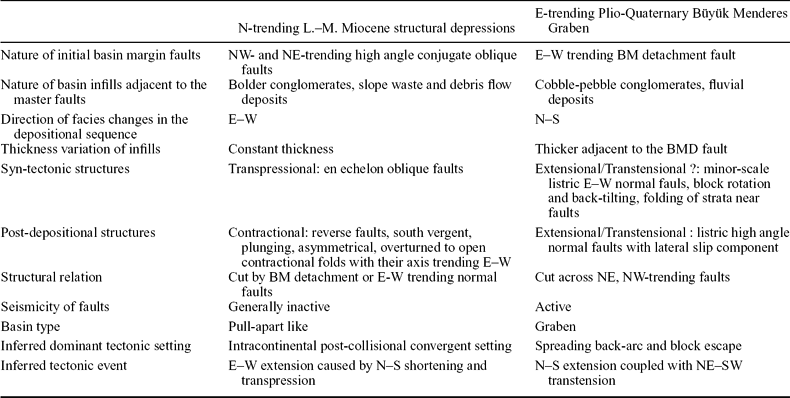
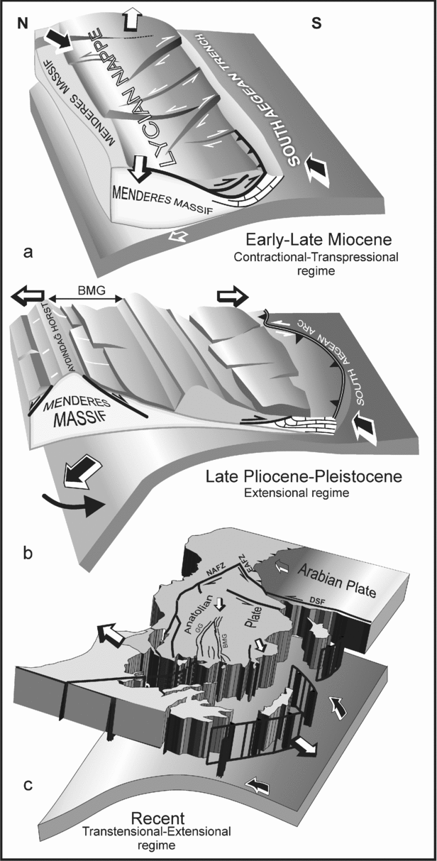
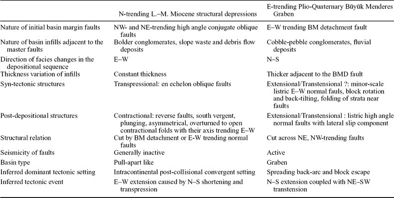
Geological mapping of the Büyük Menderes Graben has revealed the presence of two systems of structural basins of different ages and orientations. The first system is represented by N-trending structural depressions filled with Lower–Middle Miocene continental deposits. The second system cross-cuts the first one and is represented by the E-trending Büyük Menderes Graben filled with Plio-Quaternary continental deposits. The depositional features, orientation and structural relation of these basins in the Büyük Menderes Graben region are summarized in Table 2. The synthesized data suggest that two episodes of basin formation in different structural settings resulted from two successive and different tectonic regimes in the Büyük Menderes Graben region. The following paragraphs offer a tentative synthesis, reconstructing the evolution of the basins in the Büyük Menderes Graben region from their birth to the present in the light of stratigraphic and tectonic data (Figs 8, 9).
Comparison of the NW- and NE-trending structural depressions with the E-trending Büyük Menderes Graben
Basin evolution and structural geometry of the Büyük Menderes Graben.

Schematic block diagrams showing tectonic evolution of the Büyük Menderes Graben with inferred plate boundary conditions. (a) Early–Middle Miocene: onset of the E–W extension caused by N–S shortening and development of conjugate pairs of NE- and NW-trending oblique faults and related basins. (b) Late Pliocene–Pleistocene: onset of the N–S extension and exhumation of the Menderes Massif as Aydındağ Horst by the E–W-trending Büyük Menderes Detachment Fault cutting earlier N–S trending faults and initiation of basin subsidence. (c) Present day tectonic setting of the Büyük Menderes Graben.

4.a. Early–Middle Miocene
The northern branch of the Neo-Tethys Ocean was closed in Middle Eocene times as a result of the collision between the Sakarya zone in the north and Menderes Taurus Platform in the south (Şengör & Yılmaz, Reference Şengör and Yilmaz1981). Nappe slices related to the closure of the Neo-Tethys Ocean migrated southward, traversing the Menderes–Tauride platform (Graciansky et al. Reference Graciansky, Lemonie, Lys and Sigal1967; A. Poisson, unpub. Doct. thesis, Université de Paris-Sud, Orsay, 1977; Koçyiğit, Reference Koçyığıt1977; M. Gutnic, unpub. Doct. thesis, Université de Paris-Sud, Orsay, 1977; Hayward, Reference Hayward, Dixon and Robertson1984; Şengör, Reference Şengör1982; Şengör, Görür & Şaroğlu, Reference Şengör, Görür, Şaroğlu, Biddle and Christie-Blick1985; Okay, Reference Okay and Şengör1989). The late post-collisional intra-continental convergence continued in southwestern Anatolia until Middle Pliocene times, as implied by the final emplacement of the Lycian Nappes in the region (Koçyiğit, Reference Koçyığıt1977; Poisson, 1977). In the Early–Middle Miocene, this convergence and the subduction of the African oceanic slab below the South Aegean Trench created a complex tectonic event here. As a result of this event, in the Büyük Menderes Graben region, NE- and NW-trending rhomboid structural depressions were generated by conjugate pairs of oblique-slip normal faults. These NE- and NW-trending structural depressions suggest an E–W direction of extension caused by N–S contraction; strike-slip components of the faults indicate that the region was also affected by a transpressional regime. The syntectonic infill starting with chaotic boulder deposits passes into the Lower–Middle Miocene coal-bearing continental clastic rocks and carbonates (Unit A). The carbonates onlapping the structural highs of the NE- and NW-trending basins suggest a period of tectonic quiescence in Late Middle Miocene times. These basins seem to be similar in origin to rhomboid basins described in Gulf of Thailand (Kornsawan & Morley, Reference Kornsawan and Morley2002), northern and central Thailand (Morley et al. Reference Morley, Woganan, Sankumarn, Hoon, Alief and Simmons2001), Mongolian Altai (Cunningham, Reference Cunningham2005; Howard, Cunningham & Davies, Reference Howard, Cunningham and Davies2006), and San Andreas fault (Kellogg & Minor, Reference Kellogg and Minor2005).
4.b. Late Miocene–Middle Pliocene
The Lower–Middle Miocene infills of NW- and NE-trending basins are deformed by contractional folding and reverse faulting. These structures mark a contractional tectonic event with N–S directions of compression, inferred from the trends of the fold axis and strike of fault planes. Previous investigators also recognized shortening structures within the Miocene deposits in the region and southwest Anatolia (Glover & Robertson, Reference Glover and Robertson1998; Flecker, Kopf & Jurado, Reference Flecker, Kopf and Jurado1998; Yılmaz et al. 2000; Ö. Gürer et al. Reference Gürer, Bozcu, Yilmaz and Yilmaz2001; Koçyiğit, Reference Koçyığıt2005; Çiftçi & Bozkurt, Reference Çıftçı and Bozkurt2008). The contractional deformation of the Early–Middle Miocene infills and stratigraphic gap between these deposits and uppermost Pliocene–Pleistocene strata constrain the timing of this contractional event sometime between Late Miocene and Middle Pliocene. The Late Miocene–Middle Pliocene contractional phase proposed in this study agrees with the views of Koçyiğit (Reference Koçyığıt2005), who recognized late Langhian–Messinian contractional events and attributed them to the last emplacement of the Lycian nappes onto the Beydağları in southwestern Turkey. An additional mechanism responsible for the Late Miocene–Middle Pliocene contractional structures may be a change in the direction and dip angle of the subducting oceanic slab below the South Aegean Trench.
4.c. Late Pliocene–Holocene
In this area, following the contractional event of the Late Miocene–Middle Pliocene, there was a switch to pervasive extensional faulting during Late Pliocene–Pleistocene times. The exhumation of the Menderes Massif metamorphics as the Bozdağ–Aydın Mountain horst by low-angle normal faults occurred in this extensional period. Low-angle detachment faults were developed along the southern and northern flanks of the horst (Büyük Menderes Detachment Fault and Gediz Detachment Fault). Syn-sedimentary extensional tectonic events, interpreted here as induced by the E-trending master fault, the Büyük Menderes Detachment Fault, allow us to propose a polyphase evolutionary model identified with three pulses. During the first pulse, the activity of the Büyük Menderes Detachment Fault caused the deposition of Plio-Pleistocene fluvial lateral fan deposits (subunit B1) derived from the horst. They were transported into the surrounding low topography as coarse clastic materials. Away from the horst, the coarse clastics pass into the fine clastics, indicating low-energy environments, probably isolated ponds and swamps. Hence, because of the rotational displacement of the main bounding Büyük Menderes Detachment Fault, hangingwall deposits progressively tilted towards the master fault. As rotation increased, E-trending S-dipping listric faults developed in the roll-over anticline limb and caused block rotation, bed thickening and minor faulting in the Unit B deposits, as demonstrated by Gessner et al. (Reference Gessner, Ring, Christopher, Hetzel, Passchier and Güngör2001). The syn-sedimentary activity of such faults has been demonstrated by local erosive truncations and unconformities in Unit B deposits. The deposition of subunit B2 marked the second pulse in the activity of the Büyük Menderes Detachment Fault, possibly during latest Pleistocene–Holocene times. The initial stage of development of the E–W-trending high-angle normal faults, hence migration of deformation from master fault to hangingwall, corresponds to this period. As a result, the older structures and units (Menderes Massif metamorphic complex, units A, B1) were cut and uplifted by these high-angle faults. Syn-sedimentary synthetic S-dipping and antithetic N-dipping secondary listric normal faults were developed on the hangingwall of the Büyük Menderes Detachment Fault. These faults and other antithetic minor faults could be responsible for the thinning of the Büyük Menderes Detachment Fault of the hangingwall. Along the northern border, fans that were fed by the drainage network developed in adjacent relief as thick accumulations of conglomerates. This concentrated high-angle faulting elevated and back-tilted the older sediments, and localized the depocentre near the present axis of the Büyük Menderes Graben (Figs 8, 9). The Holocene migration of the present day Büyük Menderes Graben depocentres characterizes the third pulse of extensional activity in the region. Deformation in the southern side of the basin appears to be controlled by N-dipping normal faults, antithetic to the Büyük Menderes Detachment Fault. The present graben structure developed because of the large offsets of the antithetic faults. The interior of the basin is underlain by the Holocene floodplain deposits and terraces associated with the Büyük Menderes River. Additional coarse-clastic sediment was input into the basin by high-gradient ephemeral streams, mainly draining the uplifted Menderes Metamorphic Massif in the north. The historical earthquakes reported for the northern part of the Büyük Menderes Graben show that this is an active structural basin (Altunel, Reference Altunel1999; Barka & Kadinsky-Cade, Reference Barka and Kadinsky-Cade1988). The formation of diachronous secondary synthetic and antithetic steeper faults on the upper plate of the Büyük Menderes Detachment Fault, hence the southward migration of the deformation and of the Büyük Menderes Graben depocentres, should be related to the evolution of the detachment in the region. The seismic activity of the secondary faults implies that there is an active detachment system in the region. The E-trending normal faults almost always have strike-slip components; pure-slip normal faults are rare. This suggests a transtensional component accompanying the prevailing extensional deformation.
5. Correlation of the Büyük Menderes Graben with the Gediz Graben
The present E-trending Büyük Menderes Graben appears to be cogenetic with the Gediz Graben. As a mirror image, they are parallel and symetrically situated to the north and south of the Aydın–Bozdağ Horst (Fig. 10). The basin subsidence in the two graben is driven by major E-trending low-angle normal faults (Büyük Menderes Detachment Fault and Gediz Detachment Fault: Yılmaz et al. Reference Yilmaz, Genç, Gürer, Bozcu, Yilmaz, Karacik, Altunkaynak, Elmas, Bozkurt, Winchester and Piper2000). Their detachment fault-induced accessible syntectonic infills start with red continental clastics and are dated as Plio-Pleistocene (Villanian–Biharian) by small mammal fossils in both graben from 11 localities in the Büyük Menderes Graben (Ünay et al. Reference Ünay, Göktaş, Hakyemez and Şan1995; Ünay & De Bruijn, Reference Ünay and De Bruijn1998; Sarıca, Reference Sarica2000) and four localities in the Gediz Graben (Sarıca, Reference Sarica2000; Kaya et al. Reference Kaya, Ünay, Saraç, Eichhorn, Hassenrück, Knappe, Pekdeğer and Mayda2004). On the surface, the main fault and numerous synthetic/antithetic faults dissect both the bedrock and sediments. The NE- and NW-trending structural depressions filled with Early–Middle Miocene coal-bearing sedimentary rocks are present in both of the graben regions. These older Miocene structures are dissected by Plio-Quaternary E-trending detachment and high-angle faults. The magnetotelluric data suggest that these NE- and NW-trending structural depressions and intervening ridges are trapped in the E-trending Gediz Graben depression (A. Gürer et al. Reference Gürer, Bozcu, Yilmaz and Yilmaz2001, Reference Gürer, Pinçe, Gürer and İlkişik2002).
Raised relief image of western Anatolia produced from 3 arc second (~ 90 m) Shuttle Radar Topographical Mission data obtained from NASA Jet Propulsion Lab and stratigraphic relationships within the Gediz Graben (GG) (Yılmaz et al. Reference Yilmaz, Genç, Gürer, Bozcu, Yilmaz, Karacik, Altunkaynak, Elmas, Bozkurt, Winchester and Piper2000) and Büyük Menderes Graben (BMG). KMG – Küçük Menderes Graben.

6. Tectonic events in the Büyük Menderes Graben region in relation to the active N–S extension
The active N–S extension in the Aegean region including western Anatolia is defined by two tectonic phenomena: the roll-back of the subducting African plate and the west–southwestward escape of the Anatolian block along its boundary faults, North Anatolian and East Anatolian fault systems (Le Pichon & Angelier, Reference Le Pichon and Angelier1981; Taymaz, Jackson & McKenzie, Reference Taymaz, Jackson and McKenzie1991; Jackson, Reference Jackson1994; Ten Veen & Postma, Reference Ten Veen and Postma1999; Okay & Satır, Reference Okay and Satir2000; Jolivet, Reference Jolivet2001; Armijo et al. Reference Armijo, Flerit, King and Meyer2003; Ten Veen & Kleinspehn, Reference Ten Veen and Kleinspehn2003; Flerit et al. Reference Flerit, Armijo, King and Meyer2004). The onset and the continuity of crustal extension in the region and in western Anatolia are not yet unequivocally constrained and are still a matter of debate. From a structural point of view, this debate is partly due to the interpretation of structures related to the Late Cenozoic evolution of western Anatolia: whether all of the Neogene extensional structures were formed in relation to the N–S extension or whether some belong to the immediately preceding tectonic regime. For the Late Cenozoic evolution of the region, waste tectonic processes are proposed: post-orogenic contraction, transpression, extension, and magmatism, post-orogenic collapse of over-thickened crust, exhumation of mid-crustal metamorphic rocks, back-arc extension due to the subduction of the Mediterranean floor below the South Aegean Arc, active rifting in the back-arc region and magmatism, block rotation, southwestward escape of the Anatolian block along its boundary faults (the North Anatolian Fault and East Anatolian Fault). Whatever the proposed tectonic processes, one group of investigators infers a single extensional history; a second group infers a complex extensional history with changes in the stress field regime and orientation. The differences among the proposed histories suggest that the tectonic events were constrained very little.
The authors who inferred a single prolonged extensional history use: (1) Early–Middle Miocene infill of earlier NE- and NW-trending structural depressions as belonging to the E-trending graben; (2) ductile deformation in granitoids, and Menderes Massif gneisses, proposing a Cordilleran-type metamorphic core complex and Basin-and-Range-type model for the Late Cenozoic evolution of the Aegean Extensional Province (Lister, Banga & Feenstra, Reference Lister, Banga and Feenstra1984; Dinter & Royden, Reference Dinter and Royden1993; Gautier & Brun, Reference Gautier and Brun1994; Bozkurt & Park, Reference Bozkurt and Park1994; Okay & Satır, Reference Okay and Satir2000). Firstly, however, as suggested in this study, the differences in the ages of the sedimentary infill and discordant relations of the E-trending Büyük Menderes Graben and NW- and NE-trending structural depressions indicate two subsequent and independent tectonic events. Similar results were obtained for the other parts of western Anatolia (Görür et al. Reference Görür, Şengör, Sakinç, Tüysüz, Akkök, Yığıtbaş, Oktay, Barka, Sarica, Ecevıtoğlu, Demırbağ, Ersoy, Algan, Güneysu and Aykol1995; Yılmaz et al. Reference Yilmaz, Genç, Gürer, Bozcu, Yilmaz, Karacik, Altunkaynak, Elmas, Bozkurt, Winchester and Piper2000). Secondly, the results obtained from the studies on ductile deformation provided contradictory ages, as detailed in the preceding sections. The isotopically dated metamorphics do not have any corresponding sedimentary rocks controlled by the detachment fault. Therefore, the regional implications of these ages are in need of revision.
In contrast to the proposed single extensional history, our data point to complex extension with inferred changes in the stress field regime and orientation, as previously proposed by other authors (Koçyiğit, Yusufoğlu & Bozkurt, Reference Koçyığıt, Yusufoğlu and Bozkurt1999; Bozkurt, Reference Bozkurt, Bozkurt, Winchester and Piper2000; Koçyigit, Reference Koçyığıt2005). First of all, in the study area, the Plio-Quaternary infills of the Büyük Menderes Graben are often displaced or deformed by normal faults and are not affected by any contractional deformation, whereas the Lower–Middle Miocene infills of the earlier NE- and NW-trending depressions are deformed by reverse faults and overturned folds. Secondly, the E-trending major Büyük Menderes Detachment Fault and consequent secondary listric normal faults, responsible for the subsidence of the Büyük Menderes Graben, cut across the NE- and NW-trending earlier structures. Thirdly, wherever the infills of the Büyük Menderes Graben and NE- and NW-trending depressions are superposed, there is an unconformity marked by a stratigraphic gap between the Middle Miocene and Latest Pliocene strata. These data emphasize two different and independent subsequent groups of tectonic events in the Büyük Menderes Graben region. The first event is inferred as a complex event: E–W extension due to N–S contraction and transpression. This event generated the NW- and NE-trending Early–Middle Miocene structural depressions. The second event is continuously active N–S extension coupled with NE–SW transtension generating the Plio-Quaternary E-trending Büyük Menderes Graben and Gediz Graben. The first group of older events is related here to the emplacements of the Lycian Nappes in Southwestern Turkey due to the late post-collisional intra-continental convergence. The second group is thought to be caused by the combined effects of the two younger tectonic processes: (1) southward roll-back of the subducting oceanic slab under the South Aegean Arc; (2) southwestward motion of the Anatolian block along its boundary faults (westward propagation of the North Anatolian Fault in Sea of Marmara dated at 200 ka: Şengör et al. Reference Şengör, Tüysüz, İmren, Sakinç, Eyıdoğan, Görür, Le Pichon and Rangin2005). The roll-back of African slab below the south Aegean Arc seems to be responsible for the change in the stress tensor from E–W extension to N–S extension. This change is marked by detachment faulting, a kind of deformation which is known in several back-arc basins in the Aegean region (Sokoutis et al. Reference Sokoutis, Brun, Vandendriessche and Pavlides1993; Gautier & Brun, Reference Gautier and Brun1994; Bonev, Burg & Ivanov, Reference Bonev, Burg and Ivanov2006; Skarpelis, Tsikouras & Pe-Piper, Reference Skarpelis, Tsikouras and Pe-Piper2008). The second process, perhaps a cause of the strike-slip deformation, was the southwestward escape of the Anatolian block along its boundary fault, that is, the North Anatolian Fault, which reached the Sea of Marmara not earlier than 200 ka (Şengör et al. Reference Şengör, Tüysüz, İmren, Sakinç, Eyıdoğan, Görür, Le Pichon and Rangin2005).
Based on the age of the sedimentary infills, contrasting deformational structures, and discordant relations of the Büyük Menderes Graben with NE- and NW-trending structural depressions of the same area, we can infer that in the Büyük Menderes Graben region, the end of the E–W extension and the subsequent onset of the N–S extension occurred in Late Pliocene–Pleistocene times. This extension was initiated by a low-angle master fault (Büyük Menderes Detachment Fault) and is still active, as implied by the active faulting in the Büyük Menderes Graben.
Acknowledgements
The study is supported by The Scientific and Technical Research Council of Turkey (TÜBİTAK) (ÇAYDAG-105Y059). We are grateful to Yücel Yılmaz and Simon Price who critically read and reviewed the paper. Their numerous comments have greatly improved the text.