Introduction
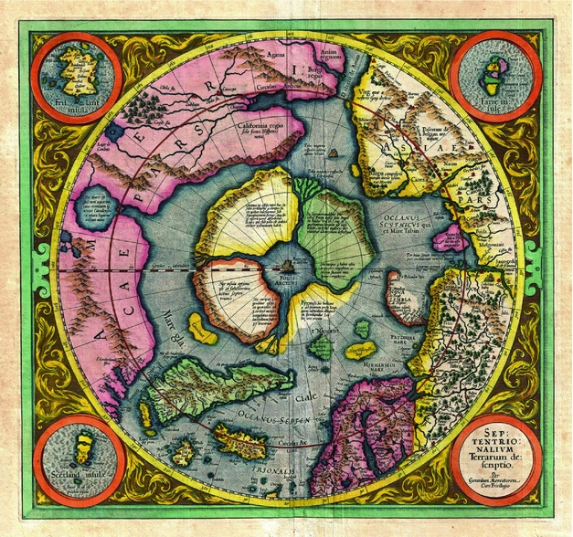
The world's oldest specific map of the high Arctic and North Pole is considered to be on Mercator's Arctic projection from 1569 (Fig. 1). Here Mercator first introduces his revolutionary polar projection. Today, the map with the landmasses centered round the North Pole, is known as pure fantasy, but for hundreds of years a central Arctic landmass was considered to be very likely. Today, the Arctic is regarded as one of the few remaining frontiers of the planet. This huge area contains some of the largest provinces of natural resources, including world-class petroleum bearing regions and several provinces with significant volumes of metals and prospective industrial minerals. As exploration moves northwards, there is a rapidly growing need to assess effectively the resource potential of the circum-Arctic region. A proper assessment must be based upon an evaluation of updated geological and geophysical data and knowledge.
The 1569 Mercator's Arctic is considered to be the world's first map of the high Arctic and North Pole (Source: www.geoexpro.com).

Further advances in our understanding of the geological history and the resource potential of the Arctic call for international cooperation. In 2003 an initiative for cooperation on a new series of circum-Arctic geological and geophysical maps was undertaken by the Russian Ministry of Natural Resources and Ecology and by the Russian Federal Agency of Mineral Resources (Rosnedra). The objective was to produce an atlas with geological and geophysical digital maps at a scale of 1:5 million for the Arctic region bounded by the 64º N latitude (60º N latitude for the northwest Europe and Canadian regions). Two years later, in 2005, an agreement was signed by a consortium of national agencies from Canada, Denmark, Finland, Norway, Russia, Sweden and the USA (Petrov and Smelror Reference Petrov and Smelror2007; Smelror and Petrov Reference Smelror and Petrov2012). In addition to the geological surveys of the respective countries, the compilation of the new circum-Arctic geological and geophysical maps has engaged a number of scientists from national academies of sciences, research institutes and universities.
The present paper provides an outline of the international coopertion resulting in the new series of circum-Arctic geological and geophysical maps, and presents an overview of the different maps and associated databases.
The bedrock map
The compilation of the circum-Arctic bedrock map in scale 1:5 million has been based on existing published material derived from digital maps of northern Europe (1:4 million), the Fennoscandian shield (1:2 million), Greenland (1:2.5 million), Yukon (1:1 million), and parts of Arctic Canada (1:5 million), and analogue sources covering the northwest Atlantic and North America offshore (1:5 million). In addition the new map is based on new unpublished information from the onshore territories, and on published and unpublished data on bathymetry, dredge samples and available seismic and potential field data for the Arctic Ocean basin.
The new bedrock map was first presented at the 33rd International Geological Congress in Oslo in 2008 (Harrison and others Reference Harrison, St-Onge, Petrov, Strelnikov, Lopatin, Wilson, Tella, Paul, Lynds, Shokalsky, Hults, Bergman, Jepsen and Solli2008). It is presented in north Polar stereographic projection, using the WGS 84 datum, and includes a complete geological coverage for all onshore and offshore areas as far south as 60º N.
The work was coordinated by J.C. Harrison at the Geological Survey of Canada, and involved participation from a number of scientists from VSEGEI, VNIIOkeangeologia, and the geological surveys of Canada, USA, Denmark, Sweden, Finland and Norway. The map was formally released in 2011 as Geological Survey of Canada Open File 5816, and is now freely available in digital format from NRCan's MIRAGE web site.
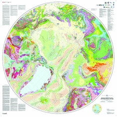
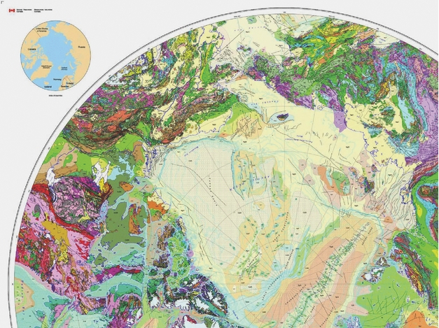
The final printed map is 1.3 m in diameter (Figs. 2, 3), and is said to be one of the most intricate map of its kind ever produced in the history of the Geological Survey of Canada. The printed map comprises 5 sheets; the bedrock map at a scale of 1:5 million with explanatory notes and the list of contributors; the legend, a Precambrian correlation chart; and two Phanerozoic correlations charts (Harrison and others Reference Harrison, St-Onge, Petrov, Strelnikov, Lopatin, Wilson, Tella, Paul, Lynds, Shokalsky, Hults, Bergman, Jepsen and Solli2008).
Bedrock map of the Arctic (1: 5 million scale) (Harrison and others Reference Harrison, St-Onge, Petrov, Strelnikov, Lopatin, Wilson, Tella, Paul, Lynds, Shokalsky, Hults, Bergman, Jepsen and Solli2008). The map is available at Geological Survey of Canada Open File 5816, and is now freely available in digital format from NRCan's MIRAGE web site.

Details from the bedrock map of the Arctic (1: 5 million scale) (Harrison and others Reference Harrison, St-Onge, Petrov, Strelnikov, Lopatin, Wilson, Tella, Paul, Lynds, Shokalsky, Hults, Bergman, Jepsen and Solli2008).

Standardisation of map unit attributes has been facilitated by the ICS time scale, drawing on the absolute scale for the Precambrian and the relative scale for Ediacarean and younger rocks. The map and digital database feature 86 divisions of geologic time based on maximum and minimum age ranges of compilation map units; 56 in the Phanerozoic and 30 in the Precambrian. The lithological range is expressed by 28 compositional assemblages: extrusive (6), intrusive (9), and sedimentary (10, based on depositional setting). Metamorphic grade data have also been collected. Precambrian map units are grouped and coded by structural domains. These include cratons (11), microcontinents and ophiolitic belts (6), magmatic arcs (8), orogens (15) and post-orogenic basins (8). These divisions facilitate and highlight the correlation of diverse but once contiguous medium and high grade terranes located within widely separated continental nuclei. In the Phanerozoic there is considerable disagreement as to an appropriate definition of terranes and domains. The problem, especially acute in the Phanerozoic orogens, is side-stepped on the new map by allowing domains to be identified informally using the distinctive compositional and age range characteristics of spatially-associated map units (Harrison and others Reference Harrison, St-Onge, Petrov, Strelnikov, Lopatin, Wilson, Tella, Paul, Lynds, Shokalsky, Hults, Bergman, Jepsen and Solli2008).
In addition to the printed map, the bedrock geology compilation also has a substantial, newly developed infrastructure. It is supported by the first complete, seamless, spatial database of onshore and offshore bedrock geology for the Arctic areas north of 60° N. The vector database includes tens of thousands of spatial objects, such as spreading ridges, oceanic crust isochrones, dyke swarms, geological contacts, faults, impact structures, active volcanoes, salt and gypsum diapirs, and kimberlite diatremes. Just to mention some numbers; there are 32,000 geological polygons, 1220 map units, 137 ICS timescale divisions, and more. These features are coded for their composition, age, environment of formation and plate tectonic domains. This archive of digital spatial data for the circum-Arctic represents an important source for the production of formal digital products and also informal user-defined map products accessed via the worldwide web. Collectively, these data can serve as a model for other digital map coverages elsewhere in the world.
Magnetic and gravimetric maps
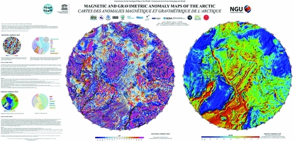
The compilation of the magnetic- and gravity maps was coordinated by Carmen Gaina at the Geological Survey of Norway (Gaina and others Reference Gaina, Aaro, Damaske, Forsberg, Glebovsky, Johnson, Jonberger, Koren, Korhonen, Litvinova, Maus, Oakey, Olesen, Petrov, Pilkington, Rasmussen, Saltus, Schreckenberger and Smelror2010, Reference Gaina, Werner, Saltus, Maus, Aaro, Damaske, Forsberg, Glebovsky, Johnson, Jonberger, Koren, Korhonen, Litvinova, Oakey, Olesen, Petrov, Pilkington, Rasmussen, Schreckenberger, Smelror, Spencer, Embry, Gautier, Stoupakova and Sørensen2011; Saltus and Gaina Reference Saltus and Gaina2007). New public and proprietary magnetic and gravity anomaly gridded data from each participant group were gathered and converted into a common datum (WGS84) and format. The magnetic anomaly compilation is based on 1 km gridded data for Canada, Alaska and northwest Europe regions, and 5 km gridded data for the oceanic basins and Russian territories (Fig. 4).
Left: CAMPGM-M magnetic anomaly compilation of gridded data (to 60° N) based on ground/airborne regional compilations and global model of lithospheric field, based on satellite data (MF6) (Gaina and others Reference Gaina, Aaro, Damaske, Forsberg, Glebovsky, Johnson, Jonberger, Koren, Korhonen, Litvinova, Maus, Oakey, Olesen, Petrov, Pilkington, Rasmussen, Saltus, Schreckenberger and Smelror2010). Right: Gravity map of the circum-Arctic, with Bouguer gravity anomaly data onshore and Free Air gravity anomaly data offshore, at a grid resolution of 10 x10 km in a polar stereographic projection (Gaina and others Reference Gaina, Aaro, Damaske, Forsberg, Glebovsky, Johnson, Jonberger, Koren, Korhonen, Litvinova, Maus, Oakey, Olesen, Petrov, Pilkington, Rasmussen, Saltus, Schreckenberger and Smelror2010).

The Greenland magnetic grid was updated with new aeromagnetic surveys performed in west Greenland between 1992 and 2001, and in the Nares Strait area. The oceanic area east of Greenland (northeast Atlantic) contains most of the aeromagnetic data used in the compilation by Verhoef and others (Reference Verhoef, Roest, Macnab and Arkani1996), plus new aeromagnetic data of offshore Norway collected up to 2007.
In order to construct the final circum-Arctic magnetic anomaly grid (CAMP-M) the authors adopted the approach used by several research groups for compiling the World Digital Magnetic Anomaly Map (WDMAM) and used near-surface magnetic data for the short wavelength component, and the satellite-derived magnetic anomalies for the long wavelengths. The final grid resolution compilation is 2×2 km upward continued to 1 km.
The new CAMP-M compilation is superior to similar gridded data of the circum-Arctic area due to its better coverage (it includes updated aeromagnetic data in the high Arctic, west and north of Greenland and in the northeast Atlantic). It preserves smaller wavelength structures by keeping the grid resolution at 2 km, and has a consistent regional long wavelength component introduced by the MF6 satellite based lithospheric magnetic model.
The new gravity anomaly compilation was originally aimed to produce a Free Air gravity anomaly and a map merging Free Air for oceanic realm and Bouguer gravity for the land realm, both at 10×10 km grid resolution. However, as a new ArcGP free air gravity anomaly grid was published by Kenyon and others (Reference Kenyon, Forsberg and Coakley2008), using the new free air data on the Siberian Shelf primarily available to the CAMP-GM project, the CAMP gravity map was then limited to the combined Free Air/Bouguer corrected data set to cover the Circum-Arctic region to 60°N. The EIGEN 115 GL04C satellite gravity models have been used for quality control of the long wavelengths.
The new gravity and magnetic anomaly maps and their derivatives have been used, in combination with the new bedrock map, to refine the outlines of some tectonic features in the high Arctic area, such as the continental blocks, micro-continents and active and extinct plate boundaries (Saltus and others Reference Saltus, Miller, Gaina, Brown, Spencer, Embry, Gautier, Stoupakova and Sørensen2011). In particular, the continent to oceanic transitions and outlines of micro-continents and volcanic provinces are better defined using the new Arctic maps.
Tectonic map
The compilation of Arctic tectonic maps was initiated more than fifty years ago by Bogdanov (Reference Bogdanov1963) and Pushcharovsky (Reference Pushcharovsky1963) who introduced 1:10 million scale maps. Later, this effort was followed by the 1:5 million scale map published by Atlasov (Reference Atlasov1969), the 1: 10 million scale map by Egiazarov (Reference Egiazarov1970), the 1:5 million scale map by Egiazarov and others (Reference Egiazarov, Ermakov, Anikeeva, Romanovich, Pol’kin, Atltsov, Demenitskaya, Grachev, Karasik, Kiselev, Andreev and Kos’ko1977), and the 1: 45 million scale map by Leonov and Khain (Reference Leonov and Khain1984). The new tectonic map of the Arctic (TeMAr) is based on the new bedrock map, and gravity and magnetic anomaly maps described above. In addition, it relies on the compilation of significant amounts of new bathymetric, geological, geophysical, isotope and geochemical data, including new seabed and bedrock samples obtained during recent the field studies in the high Arctic land areas and the polar ocean (Petrov and others Reference Petrov, Sobolev, Morozov, Grikurov, Shokalsky, Kashubin and Petrov2012, Reference Petrov, Smelror, Shokalsky, Morozov, Kashubin, Gurikurov, Sobolev and Petrov2013). The TeMAr compilation was initiated in 2009 under the leadership of Petrov (VSEGEI Director and CGMW Vice-president), and Sergey Shokalsky (Secretary General of Sub-commission for Northern Eurasia) under the Commission for Geological Maps of the World supervision (Petrov and others Reference Petrov, Smelror, Shokalsky, Morozov, Kashubin, Gurikurov, Sobolev and Petrov2013).
In 2010 an international working group was established, and the map legend was agreed in April 2011 (Paris, CGMW). In April 2012 the first TeMAr draft was discussed at the workshop that took place at the Austria Geological Survey in Vienna. A preliminary version of the map was first presented at GeoExpro-2012 at the 34th International Geological Congress in Brisbane 2012 (Petrov and others Reference Petrov, Smelror, Shokalsky, Morozov, Kashubin, Gurikurov, Sobolev and Petrov2013). The final version of the tectonic map is currently being revised to include new data from the Barents Sea recently published by Gernigon and Brönner (Reference Gernigon and Brönner2012).
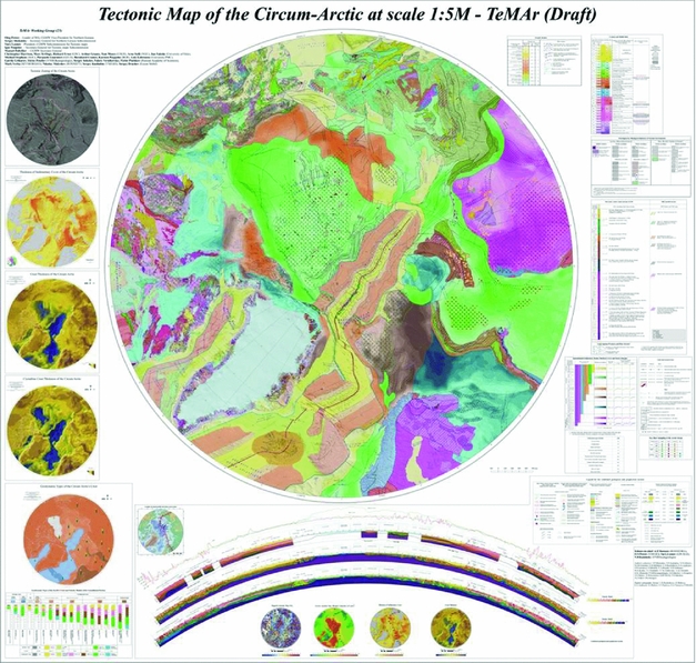
The tectonic map shows major crustal elements of the circum-Arctic such as Neoproterozoic and Phanerozoic orogenic belts, cratons and sedimentary basins, and the rift structures formed in the course of oceanic floor spreading in the North Atlantic (North Atlantic Ridge) and central Arctic (Gakkel Ridge) oceans.
Many structures that are traced from the land throughout shelf regions and into deep water in the Arctic Ocean show a tendency to rejuvenation northwards from Russia to the Canada Basin. The Urals were formed in the Late Carboniferous - Permian, and the of Polar Ural, Pay-Khoy and Novaya Zemlya fold belts in Late Permian - Triassic times. The Triassic traps of eastern and western Siberia were subsequently replaced by early Cretaceous basalts of the high Arctic large igneous province (HALIP).
The tectonic map further illustrates the Cainozoic rifting and subsequent spreading (ca. 56 Ma) in the North Atlantic and Eurasian ocean basins and subsequent rapid subsidence of the Central Arctic elevations to bathyal and locally abyssal depths around 20 million years ago.
The new tectonic map includes a set of accompanying inset-maps, showing deep structure of the regions, tectonic zoning of the basement and the sedimentary cover, geodynamic types of the sedimentary basins, boundaries of the large igneous and more. The inserted crustal thickness map is compiled by VSEGEI, Sevmorgeo and VNIIOkengeologia based on more than 200 deep seismic profiles. It displays the areas of continent crustal stretching and thinning in the high Arctic. Another important add-on to the tectonic map is the sketch map of crustal types, with the legend on crustal types and seismic velocity models.
An extra add-in to the tectonic map is a crustal-scale transpolar geotransect that stretches for 7600 km long geotransect from the Fennoscandian Shield to the coast of Okhotsk. This transect has been compiled using deep seismic profils and gravity data. The profile clearly depicts the domains with normal and thinned continental crust, and the oceanic crust domain in the Eurasia Basin.
The new tectonic map of the Arctic presents our current model of the geological history of the circum-Arctic. It will certainly be refined as new geological and geophysical data are gathered from this large frontier. The tectonic map will aid the development of an agreed standpoint on the geological structure and tectonic history of the geological complex and vast Arctic territories (Fig. 5).
Tectonic map of the Circum-Arctic (draft, in scale 1:5 million) (Petrov and others Reference Petrov, Sobolev, Morozov, Grikurov, Shokalsky, Kashubin and Petrov2012).

Ore mineral resource map
The Arctic and the high-north territories contain large amounts of ore mineral resources which are likely to be explored and developed in the forthcoming years. Information on these mineral resources is available in the archives and databases of the geoloical surveys and other national agencies. The next step in our circum-Arctic atlas cooperation will be compilation of a database and a map showing the main occurrences of the ore mineral resources. The focus will be on onshore and near-shore deposits, but offshore occurrences will also be shown in the map.
The compilation will be coordinated by the Geological Survey of Norway under the supervision of Ron Boyd and with involvement of experts from the geological surveys of Canada, Denmark/Greenland, Finland, Russia, Sweden, Norway and USA. The current Fennoscandian Ore Deposits Database (FODD; http://new.gtk.fi/informationservices/databases/fodd/index.html) is proposed as a template for this work. This database covers the Fennoscandian Shield and is developed in cooperation by the geological surveys in Finland, Sweden and Norway and the Russian Federal Agency of Mineral Resources. A simplified bedrock base-map to be used in the project is provided by the Geological Survey of Canada, and large parts of the data are already in place. The project will be completed in 2016 (Boyd Reference Boyd2014).
Conclusions
As a result of a cooperation initiative proposed by the Russian Ministry of Natural resources and Ecology and by the Federal Agency of Mineral Resources (Rosnedra) in 2003, a series of circum-Arctic geological and geophysical maps at 1: 5 million scale have been compiled (that is bedrock map, magnetic anomaly map, gravity anomaly map), whereas the tectonic map, and the map of ore mineral resources are in progress.
The interest in the Arctic and its natural resources will continue to increase in the coming years, and a knowledge- and research-based approach is needed. Cooperation on production of modern and accurate geological and geophysical data and maps is a neccessary step towards a common understading of the potential and limitation of the natural resources of the Arctic regions.
Joint work at the Atlas of Geological Maps of Circumpolar Arctic under the aegis of the Commission for the Geological Map of the World (CGMW) stimulate further development of relations between geological surveys of participating countries and contribute to the formation of an international scientific school of geological cartography.
Acknowledgements
We would like to thank the following researchers for their contributions to the circum-Arctic atlas project: I. Artemieva, H. Brekke, B. Cramer, S. Drachev, R. Ernst, J. I. Faleide, C. Gaina, A. Grantz, G. Grikurov, P. Guarnieri, C. Harrison, S. Kashubin, L. Labrousse, N. Malyshev, T. E. Moore, A. Morozov, V. Puchkov, K. Pierpjohn, I. Pospelov, V. Poselov, S. Shokalsky, N. Sobolev, S. Sokolov, A. Solli, M. Stephens, M. St-Onge, M. Verba, V. Vernihovsky. We are also thankful to the Commission for the Geological Map of the World for deep interest in this project and continuous support, and all the participants of the working group for their contribution.