Introduction
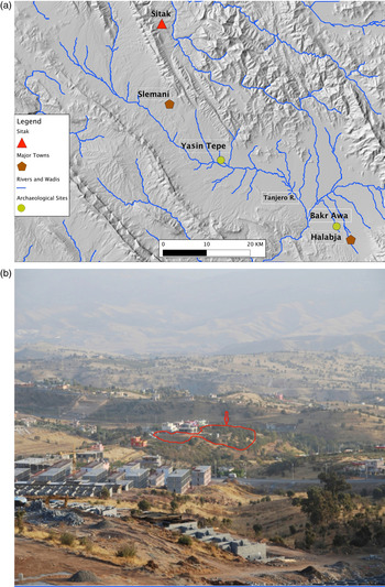
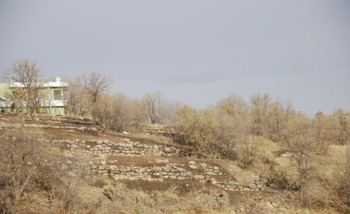
Tell Sitak (545534, 3944367 UTM 38N) sits along a ridge in a mountainous area (Fig. 1a) of Slemani (Suleymaniyah) province in the Kurdish Autonomous Region of Iraq; the excavated part of the site is found in a newly built area in the town of Sitak (Fig. 1b). Modern buildings have likely obscured or damaged part of the site and only a portion of the site has so far been uncovered. The known total size of the site is at least 0.2 ha. The site is located at an elevation of 971 m above sea level; steep ravines would have made it relatively difficult to access in antiquity. The region's natural flora includes almond, walnut, and oak trees, while wild mountain goat can still be found there. The name of the site, Sitak, derives from the modern town that encompasses it. The name originates in two Kurdish words, “three singles”. Modern Sitak is one of four towns that extend from west to east along a difficult mountainous route connecting to the modern border with Iran. The towns are 10–30 km from each other, and their names reference the numbers two through five (thus Dukan is named for two, Sitak has the word “three” as part of the name, Chewarta is four, and Penjwin is five). The ancient name of the region is Kelmzien, which means in Kurdish “absorbent soil”. This name likely derives from local people observing that over the years the area's terrain was shrinking (i.e., subsiding), which could have been due to natural changes such as erosion, seismic activity, or subsurface hydrologic changes, including extraction or discharge of groundwater. In fact, during the season we witnessed a large movement of earth from the top of the hill to the ridge along the wadi edges during periods of precipitation.
Map of the region near Tell Sitak and nearby major archaeological sites (a) and photograph showing the outline of the known area of the site (b).

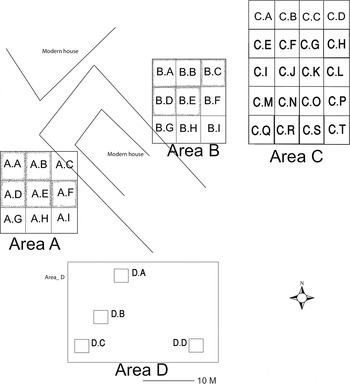
The site was selected for excavation as a salvage project due to recent building activities that exposed a large quantity of ceramics. Previously the site was unknown, but with the exposure of both ceramics and stone foundations, local authorities alerted the Department of Antiquities in Slemani province and excavations began promptly, with a salvage project starting in October 2010. During excavations it became apparent that the site has been damaged by military activity, likely from the Iran-Iraq war, with tree growth, including large tree roots, damaging walls. Three areas of excavation chosen were designated Areas A–C, with individual excavation squares measuring 5 × 5 m (Fig. 2). Area D was opened only in the last week of excavation; four exploratory squares measuring 2 × 2 m were opened. Area D, located to the south-west of Area C, was opened after the discovery of a large wall made by an owner of a house. Overall, three levels were exposed, with Level 1 having two building phases. We date Level 1 to the Sasanian period and Levels 2–3 to the Neo-Assyrian period. Evidence of post-Assyrian occupation is evident in Level 2, suggesting that the site continued for some time after the end of the Neo-Assyrian period. No further archaeological levels were found below the Neo-Assyrian layers; however, it is unclear whether virgin soil was reached in all areas. The material presented below moves from the oldest to the youngest layers.
General plan of areas excavated.

Archaeological Results
Level 3
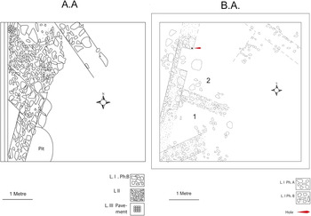
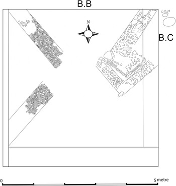
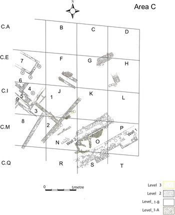
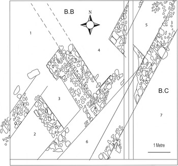
A structure or group of structures, between 1.8 and 1.0 m below the surface, were uncovered in the two northern areas (Areas A and B) and to the east (Area C); these represent the deepest areas reached by the excavations. In square A.A, a pavement made of small fragmentary stones was found that sloped to the west. Small parts of a wall and pavement were also identified (Fig. 3). In Area B, which is 15 m northeast of Area A, square B.A reveals groups of stones perpendicular to the west section of the square; this is interpreted to be the same level as Level 3 in Area A, based on its similar architectural orientation and cultural remains, although this identification is uncertain. To the east of this, and partly extending into the north-east part of the section, a group of small stones extending over 2 m is evident. While much of the intact architecture dates to Level 1, small areas of floors associated with Level 3 are evident. This is also true for loci 1 and 2 in the square. To the east, in square B.B, reaching a width of 1.1 m, a base of a wall made of small stones was found (Fig. 4). The north-west corner of B.C shows remains of a paved floor made mostly of small stones; adjacent to the northern wall, a large stone with 35 cm height was found, which was worked and could have formed part of an installation the nature of which is unclear. In the western part of B.B are two walls with bases formed of very small stones. Within B.B, the north of the square is disturbed by a later pit. In Area C, some undisturbed walls were found to exist, but unfortunately there was no time to properly excavate this level for the area. Square C.O may show an earlier phase of tower fortifications, with two half-circle shaped structures found (Fig. 5). Squares C.F, C.G, and C.J show some evidence of wall foundations or architecture from the level. While the remains of this level are not clear, we interpret them to be likely remains of a fortress, perhaps the earliest phase of the structure more clearly evident in Level 2.
Squares A.A and B.A architectural remains.

Square B.B remains.

Plan of Level 2 in Area C and remains of other levels.

Level 2
This level ranges between 1.0 and 0.3 m below the surface in areas excavated, with some areas even protruding above the surface in parts of the site that are more sloped. The remains in this level are much more substantial than those in Level 3, with large and worked stones incorporated into walls that have flat surfaces. The large structures uncovered in this level are paved with courses of large sandstones (Fig. 5). At this stage the site clearly becomes a fortification, with evidence of three walls having defensive towers. To the east in Area C, the fortifications are particularly evident near a wadi (Fig. 6). This area proved to be the most intact of the areas excavated. A large wall, perhaps a large outer defensive wall, was found protruding toward the wadi. This wall was constructed of large stones with dimensions approximately 110 × 40 × 40 cm and 40 × 40 × 40 cm.
Protruding stone walls from Level 2 in Area C.

The builders of Level 2 largely used mud brick and stone in the inner architecture of the area, with the stones of different sizes in the centre of walls and long stones used as bonding for the facing and fill stones. Small rectangular stones are also hewn and incorporated into the walls that closed different gaps between the larger stones in the facing. The uncovered structures are interpreted as part of a fortress compound (Area C), with Areas A and B perhaps being barracks, living quarters, or even facilities for fortress administration. The following provides further description regarding these exposed structures.
Fortifications
Two large and long walls running south-west to north-east (Walls 1 and 2) and parallel to one another represent the clearest evidence for fortifications (Fig. 6). The first wall is supported by two square-shaped towers and the distance between the towers is 2.75 m, with the area between forming an alcove. The length of the first tower (C.P) is 3.75 m, while the second (C.S) is 2.75 m. The two towers protrude roughly 1 m from the wall. The width of the larger tower, which is constructed of large flat stones, reaches 2.9 m. The height of the wall preserved is 1.25 m, with four courses of large stones evident. At 3.5 m distance from the first wall the second wall is found, also built from large flat stones. The width of this wall is 2.25 m. Later secondary structures, specifically a rounded stone-lined structure and a rounded enclosure (C.O) between the two large walls, were also found. Such remains emphasize the potential strategic significance of the site as a fortified area. The two large walls lie at slightly different elevations, with the second wall on slightly higher terrain. This suggests a form of double fortification with the second wall having been potentially higher. The remainder of Area C displayed few clear remains in this level; however, a cuneiform tablet was recovered in locus 1 (C.J), along with other finds discussed below.
Living Units
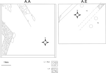
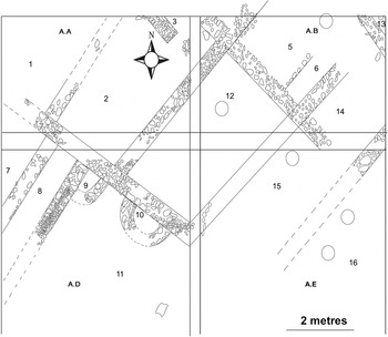
While the structures in Area A are unclear, they likely formed at least two units. In this case, remains of paved floors are found with courses of sandstones. The pavement is laid out without any gaps between each paving stone. Unfortunately, there is a large disturbed area where pavement would have been, disrupted by a large storage jar installation from an early phase of Level 1 (Phase B). A later phase in Level 1 (Phase A), with foundation stones for a structure, disturbs this area and extends over the level of the ancient surface. In all the squares in Area A, the remaining architectural finds largely included pavement stones and wall foundations. Overall, the area excavated in Area A for the level reached 380 m2 in squares A.A–A.F. The finds did include a large courtyard with a decoration of a small incised Assyrian style flower on a pavement stone in the floor (A.D). It is likely that similar decorations would have lined the surrounding walls. In squares A.A and A.E there is evidence of some intact architecture with wall and foundation remains (Fig. 7). In square A.E, a kiln, three storage jars (circular features indicated), and foundations of a stone wall from Level 1 also heavily damaged Level 2. Two intersecting walls, forming a corner, are found in the west part of A.A. These walls are about 1 m wide.
Architecture from Area A (A.A), showing Levels 1 and 2, and A.E, showing Level 2.

In Area B, a modern house had been constructed, which helped to reveal architectural remains of two ancient structures. In B.A, there is evidence for sandstone pavement in the ancient structures, of the same type as that found in other parts of Areas A and B. In B.D, including in locus 1, similar pavement was found. In B.E., evidence of modern bomb remains are visible, indicating destruction from relatively recent war damage on the site (probably from the Iran-Iraq war). In addition, oak tree roots are damaged this area. The remains mostly include foundation stones, but the structures must have had substantially wide walls, with the wall remains ranging between 0.4 and 1.5 m in width. Such features suggest that this may have been a large building, perhaps an administrative or multilevel structure. Features from B.B–B.D are described in further detail below.
Structures in Area B
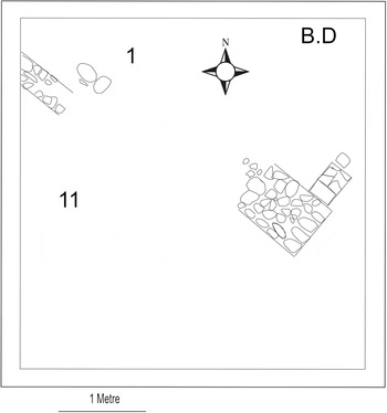
In Area B, at least two units are evident for Level 2. Structure 1 (locus 1 and 11) is found in square B.D. Possible threshold stones are found in locus 1, indicating that this could have been one of the entrances to the building and locus 11 could have been a street or courtyard. Perhaps a door socket would have been located in the pavement stone, but the stones are broken and therefore this is unclear. The south corner of the wall in locus 1 is relatively wide, at nearly 1 m, while the other walls are c. 40 cm in width.
Structure in B.D found in Level 2.

The structure described above (1 and 11) from B.D. extends into square B.B, which may have included loci 1–3 and possibly 6 in B.B. The entrance between loci 1 and 3 in B.B has a large threshold stone and protrudes out of the entrance by 70 cm (Fig. 9). Squares B.B. and B.C are distinguished by two loci (loci 4–5) with wide walls, between 1.0 and 1.5 m width, in squares B.B and B.C. These two loci could form a second structure in Area B Level 2. One of the pavement stones (locus 5) also had a small, incised Assyrian style flower. Outer walls of the structure are in B.C and B.E. In the north section of B.C., an intrusion from a building in Level 1 resulted in parts of the wall in the north section of B.C. being slightly disturbed. Part of an intact pavement of sandstones included two stones each decorated with a line incision in locus 7 in B.C. Locus 6 possibly served as an alleyway or corridor connecting to locus 5. The loci finds in Area B are all likely to be part of at least two structures, with loci 4–5 forming part of the second structure.
Architectural remains from B.B and B.C in Level 2.

Level 1B
In Areas A through C, evidence for buildings in Level 1 are found, with two identified phases (A and B); Area C mostly has evidence for Phase B, which is the oldest phase, but some evidence of Phase A is also evident there (Fig. 5). Area D was also explored, but revealed few architectural remains, as it was on a steep area to the south and the mostly mixed pottery that was found there suggested significant erosion had destroyed this part of the site. The level is characterised by remains of iron works, including tools, kilns, slags, and ore.
In Phase B, there is evidence of levelling of the surface and filling parts of the level with reddish sediment. Walls in Area C are generally about 0.8 m wide during this phase, with walls faced with large stones. Some of the stones might have been reused from Level 2 architecture. In Area B, the walls are generally weakly built using smaller stones. The architectural and material remains found indicate living quarters and/or workshops for iron making.
Area A
The remains in Area A are not well preserved (Fig. 10). Walls of rectangular rooms are evident (e.g. loci 2, 5 and 12). In A.A, some floor pavement of sandstone was found between two parallel walls that had a north-east–south-west direction. Square A.B shows wall remains datable to Phase B. A small secondary room or installation is evident in locus 6. In A.D round installations, likely for storage, are evident (loci 9 and 10). In A.E. partial remains of a kiln are found. The kiln was excavated into the ground at a depth of nearly 1 metre, with evidence of burning that affected the paved floor of Level 2. The kiln is poorly preserved and difficult to delineate. There is evidence of iron slags and a mixture of Level 2 pottery, with animal bones mixed into the kiln's remains. Other finds include a group of large storage jars, shown as circled installations in loci 15 and 16, next to the kiln. These jars measure 1.2 m in length with 30 cm diameters and are installed in deep pits. Possibly they were used for grain storage. In A.B, similar storage jars are evident in loci 5 and 12.
Area A architecture datable to Level 1A.

Area B
Square B.A (Fig. 3) shows evidence of two clear loci (1 and 2) separated by a 0.5 m wall. Architectural evidence in square B.A shows a structure with a niche wall facing west. Only one course of stones is preserved, with the exception of parts of the western wall that has multiple courses. In the west wall in locus 2, a niche is evident. A stone with a likely door socket indicates the niche served as a doorway at an earlier phase or the door socket stone was reused in construction. Another wall, running south-west–north-east was also found, but this wall is heavily damaged.
Area C Structures 1–3
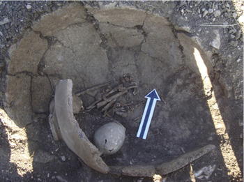
In Area C (Fig. 5), remains of rooms were found that could belong to buildings designated as Structures 1 (loci 3 and 8, possibly 2) and 2 (loci 1, 4, and 6, possibly 7). The walls incorporate large or long courtyards and rooms (loci 1, 2, and 8); one of the rooms (locus 3) seems to have very large stones used for its construction. Loci 5 and 9 may have formed parts of alleyways that connected the two structures. Loci 1 and 2 have evidence of building during Phase A; however, these features may have initially been constructed in Phase B. Only parts of the loci in Area C were uncovered due to a shortage of time; however, further structures in C.C., C.G, C.H, and C.F would likely be uncovered if further excavation continued. Two large walls were found in squares C.C and C.H. These likely belong to a further structure, designated as Structure 3. While the remains found in this structure seem to date to the later Phase A, it is possible that the surrounding architecture dates to Phase B. The outer entrance to this structure is possibly located in C.D, but this is not clear. One large jar burial of an individual buried in a flex position with a small jar found next to the skeleton was found under the floor in C.O (Fig. 11). Evidence for iron working was also found here, with debris of iron slags scattered around and near the grave.
Jar burial of an individual in a flex position in C.O.

Level 1A
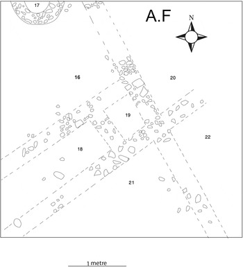
In Area A, the remains of this level are mostly foundation stones, which are only preserved to a height of a few centimetres and sometimes protrude slightly through the surface. In places, however, the level penetrates below the floors of Level 2. Some reddish sediment is evident as fill and was likely used to even the level in the hilly terrain. The architecture seems to be a rebuilt phase of level 1B, while also perhaps extending beyond the extent of the earlier phase, with storage jars, kilns, and new structures evident. New small storage areas with circular walls are evident in square A.F (Fig. 12), similar to that seen in Level 1B. In A.F, the walls are built with small and medium-sized stones, with the wall widths ranging between 70 and 80 cm. Most structures do not show evidence for very substantial or large-scale construction; however, large stones derived from Level 2 appear to be incorporated into the walls of 1B.
Plan of Level 1A in A.F.

In Area C (Fig. 6), loci 1 and 2 and the walls in C.D, C.G., and C.H are by this level established. Storage jars in C.E and C.I are now apparent as well. In C.J and C.N, ephemeral walls were found, likely representing another sub-phase within Level 1A. In Area D, the steepness of any architectural context was impossible to determine for this phase, although, as stated, architecture was revealed during modern building construction on the site. This phase likely represents modifications to the Level 1B living and iron making/workshop areas.
Archaeological Finds
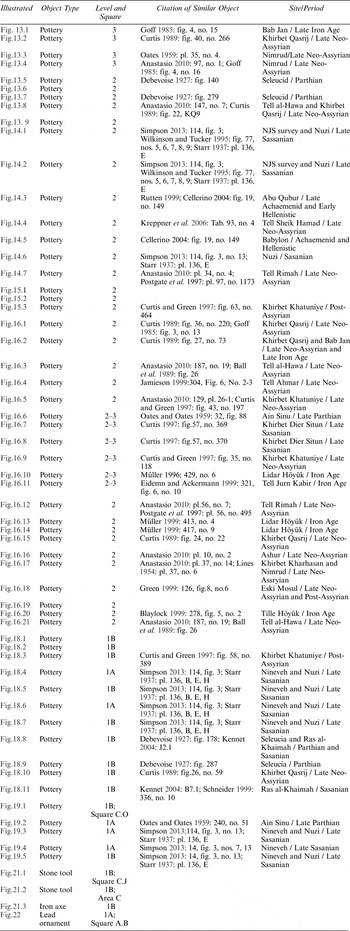
Here we provide descriptions of the types of remains found in the levels exposed. Unfortunately, many descriptions for the ceramic materials and inclusions are not available for individual sherds; however, general descriptions of the finds are presented. In addition, comparative ceramics from other sites are cited for sherds discussed. Table 1 lists finds from Sitak and the dated parallels. Other objects, including a Neo-Assyrian cuneiform tablet, are also discussed.
Sherds and other objects found at Tell Sitak with comparable sites and periods given.

Finds from Level 3
Ceramics
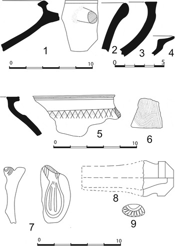
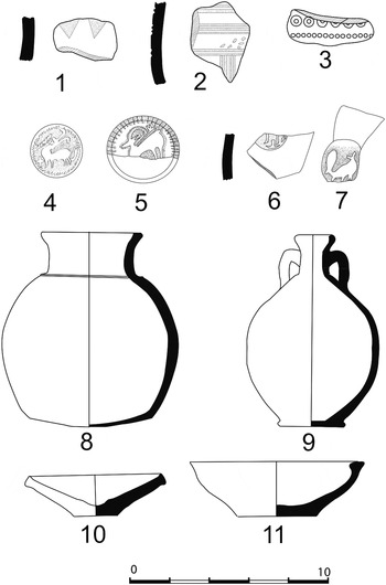
Finds from Level 3 include a relatively limited number of ceramics, likely due to the disturbed areas found in the layer caused by later ancient building activities. This likely means that some of the pottery from Levels 1 and 2 have mixed with Level 3, as there are various similarities noticed. This has forced us to look at the ceramics more carefully in Levels 3 and 2, paying particular attention to those found on Level 3 floors, as these are more likely to be of a secure context. Common body colours are brown and grey, with reddish colour lacking in general. From the styles observed, the majority of the ceramics that derive from relatively secure contexts are dateable to the late Iron Age (Fig. 13.1–4; Table 1), with finds showing parallels to seventh century b.c. ceramics from Nimrud (Oates Reference Oates1959) and Khirbet Qasrij (Curtis Reference Curtis1989).
Ceramics from Levels 3 and 2.

Finds from Level 2
Level 2 is affected by significant building activity from Level 1 that has also mixed some of the remains in this level. Level 1's Phase B walls' foundations, in fact, reach into Level 2 in some places. Nevertheless, some observations can be made regarding the pottery types found in this layer.
Ceramics
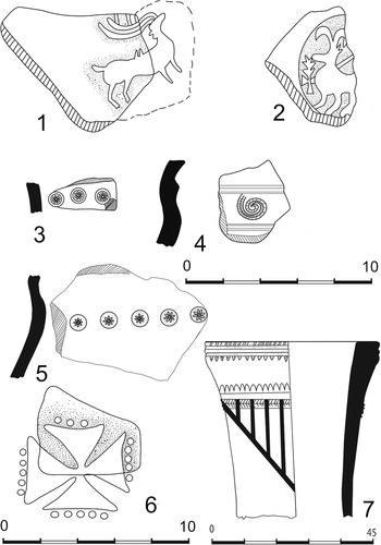
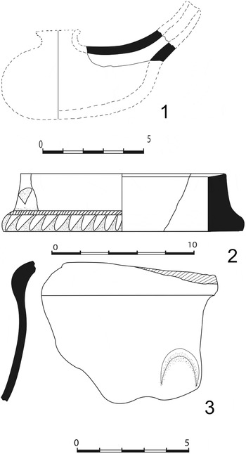
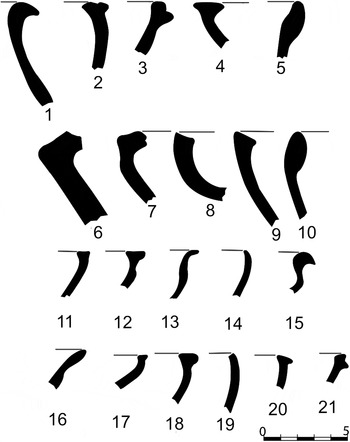
In general, what is clear from pottery styles found in this level (Figure 13.5–9; Figs. 14–15; Fig. 16.1–5, 12–21) is that there is a mixture of late Iron Age (Figs. 14.7, 16.3, 12–16) wares similar to forms seen at Tell al-Hawa (Ball et al. 1995) and late Sasanian (Fig. 14.1, 2, 6) styles similar to those evident at Nuzi and Nineveh (Simpson Reference Simpson, Peruzzetto, Metzger and Dirven2013). On the other hand, some ceramics could date to the early Hellenistic period (Fig. 15.3), but such sherds are generally fewer. A few ceramics (Fig. 16.6–11) are found mixed between Levels 3 and 2. Overall, the ceramics are mostly of reddish clay, with some containing small white grit or chalk-like temper; Iron Age sherds have chaff temper, and various types of sherds in the level have sand temper. No complete vessels were found.
Ceramics from Level 2.

Ceramics from Level 2.

Level 2 and Levels 3–2 mixed sherds.

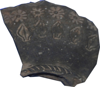
As indicated in Figure 14 (e.g. 1 and 2), some of the ceramics are impressed. Common impressions include gazelles with long cylindrical antlers, while crosses with gazelles or by themselves are also evident. Such impressions have clear parallels to late Sasanian wares (Simpson Reference Simpson, Peruzzetto, Metzger and Dirven2013), as indicated in Table 1's object comparisons. Similar impressed ceramics are found in Level 1, while the Iron Age styles are more comparable to pottery from Level 3. Other notable finds include a pottery stand with a rim pointed outward, deep impressions on the surface and a finger-shaped impression on the body (Fig. 15.2). Another ceramic shoulder sherd has a design of a crescent on the body (Fig. 15.3).
Tablet
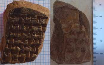
In locus 1 in square C.J and on the floor, a small clay tablet fragment with text in Neo-Assyrian cuneiform script was found (2.7 × 4.0 × 2.5 cm; Fig. 17). According to Karen Radner (in press), this is a legal document concerning a field and seven people, most likely their sale. On the poorly preserved reverse that has a witness list, no date is preserved, and too little of the text remains to suggest a circumstantial dating. The document is sealed with the impressions of fingernails, of which traces of three can be seen on the left side of the obverse, just above the horizontal line—a practice that is attested throughout the Neo-Assyrian period (Radner Reference Radner1997: 38 with n. 177).
Neo-Assyrian tablet found in Area C's (C.J) locus 1 (photo courtesy of Professor Karen Radner; left side is obverse and right is reverse).

Other Finds
Other finds include a ceramic sikkatu peg, found in square B.B locus 6 and in the debris, likely placed on the wall as decoration itself or for hanging other decorations. In addition, a small fragment of frit in the shape of an Assyrian flower was found in square A.B, similar to examples known at other sites from the late seventh century b.c. Both the mounting and frit are reminiscent of similar late Iron Age and Neo-Assyrian objects in Iraq and north-western Iran (Mallowan Reference Mallowan1966: 82; Albenda Reference Albenda1991: pl.9; Bahman and Ali Reference Bahman and Ali2009). Another find is a large ceramic bead that was discovered near a bronze chisel on the floor of locus 1 in C.J, which is near where the tablet was found. In the same locus, three fragile baked bricks were found and measure 32 × 32 × 7 cm, which is within expected dimensions for Iron Age or Neo-Assyrian bricks (Robson Reference Robson1999: 289). In B.E., an incised stone object with Assyrian style decoration, perhaps part of a threshold, was also found, but it appeared to have been moved from its original place (Fig. 20).
Finds from Level 1B
Ceramics
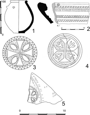
Unfortunately, there was not enough time to properly draw many of the objects from Level 1B; however, we will discuss general trends and show key findings from this level. From Level 1B, finds include impressed fragments, similar to those mentioned for Level 2. Impressions include gazelles (Fig. 18.5), Maltese-like crosses (Fig. 19.5), flowers and hatchings (Fig. 18.2). These again suggest parallels to late Sasanian finds such as those from Nuzi and Nineveh (Simpson Reference Simpson, Peruzzetto, Metzger and Dirven2013). The large burial jar found (Fig. 11; Fig. 19.1), is cylindrically shaped with two small stump handles attached to the body. The ceramic colour is yellow-reddish with small sand inclusions. The ceramic also has a glaze of dark greenish colour with a slightly gold lustre. Small sherds found in the layer have a similar glaze to this larger burial ceramic. Among other finds, some sherds show a yellow coloured wash. For the most part, the ceramics have inclusions of fine sand and sometimes fine chaff or no chaff. In locus 3 (square C.I), a complete jar of reddish clay colour was found, with sand temper, a rounded body and a slightly arched base. A small cone-shaped lid made of yellowish clay was also found in this locus. The rims and base of the lid are string cut. Finely made plates (Fig. 18.11) with sand and chaff temper were found; once again the wash is of yellow colour. Fragments of impressed wares were also found. Other fragments featuring floral elements and repeating incised circle designs were found (Fig. 18.3). The large storage jars found in Level 1B are elliptical in shape with ring-shaped rims, arched-shaped or flat bases, and red or yellow in body colour. These are generally well fired, although a few were more poorly fired. One storage jar has a pomegranate symbol incised into it. There are also examples of other types of incised wares (Fig. 18.1–2). In general, comparing the manufacture of ceramics between Levels 2 and 1, we see that ceramics in Level 2 are generally better fired and more finely made, while Phase B in Level 1 is of medium quality. By Level 1A, the firing quality is even worse than that seen in Level 1B. While late Iron Age remains still appear in Level 1, the majority of ceramics in this level are dated to the Sasanian, likely late Sasanian, period. Figures 18 and 19 show styles found in this phase.
Finds from Level 1.

Finds from Level 1.

Incised stone with three bands of decoration.

Iron Tools
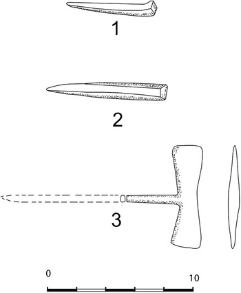
As stated, a variety of iron slags, ore, and tools were found. In B.A, within the remains and floor of locus 1 (Fig. 3), two pavement stones and tools were found together, including an iron axe (Fig. 21.3) and pick. In C.J, a small chisel (Fig. 21.1) was found, while other larger chisels were found in various places in Area C (e.g., Fig. 21.2). Such chisels could represent remains of a workshop on the settlement.
Iron tools found in Level 1B.

Other Objects
Other finds include stone tools, including grinding stones, sharpening tools, pestles, weights, and loom weights.
Finds from Level 1A
Ceramics
Impressed sherds were found once again, including those depicting gazelles (Fig. 19.4), large flower decorations, bulls, Maltese-like crosses, and circular designs. One Maltese style cross includes an outer circle with jagged edges (Fig. 19.3). This indicates that some of the types of stamp impressions found in earlier contexts continued, while new themes also emerged. These include the crescent-shaped designs that incorporate a large cross (Fig. 19.4), horned animals (Fig. 18.4), and others. The crescent design, similar to that of the cross, has parallels to late Sasanian impressions found at Nineveh (Simpson Reference Simpson, Peruzzetto, Metzger and Dirven2013). The ceramics in the level are generally of pinkish, brown, yellow, and dark and light reddish colours or washes. A part of a lamp was found along with decorated body, rim, and base sherds (Fig. 19.2).
Other Finds
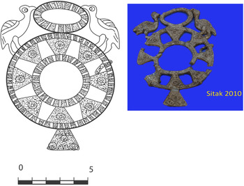
A mould-made lead ornament, perhaps part of a ritualistic sceptre, was found in the debris of A.B. The object is designed with two rings; the bigger ring has trapezoidal-shaped decorations with two birds sitting on the outside and in between them lies the smaller ring (Fig. 22). This object is reminiscent of Luristan-style bronze objects and appears to have Iranian-themed iconography (e.g., ostrich-like birds, triangular and circular geometric elements; cf. Pigott Reference Pigott and Pigott1999). Other small objects include small blue glass fragments.
Level 1A's lead ornament.

Conclusion
The finds from Levels 3–2 suggest that Tell Sitak was occupied during the late first half of the first millennium b.c., sometime around the seventh and sixth centuries b.c. or late Iron Age. The finds of Hellenistic or post-Assyrian wares (e.g., Figs. 14.5 and 15.3) suggest the site may have continued into the Achaemenid period. A later Sasanian occupation in Level 1 is evident, suggesting reuse of the site at this time. However, because there is considerable damage to the site, both from recent building activity started prior to excavations and from ancient earth moving activities, the stratigraphy of the site is complex and not easily resolved in all excavated areas. Level 3 does not have substantial remains and is only partially evident in a few places excavated, including A.A, B.A, B.B, and Area C. The ceramics, where found in secure context, are datable to the late Iron Age in this level. In Level 2, and as made evident in the discussion and ceramic descriptions, many areas are mixed and likely disturbed, with a mixture of Sasanian, probable Achaemenid /Hellenistic, and Neo-Assyrian or Iron Age III pottery styles. The remains that are found in better contexts likely indicate a Neo-Assyrian and more general Iron Age III date for the level. The presence of the cuneiform tablet, decorative objects, architectural remains, and ceramics from less disturbed contexts suggest this is a reasonable conclusion for Level 2. However, ceramics of slightly later date do suggest the site may have continued for some time after the fall of the Assyrian empire. For Level 1, both Phases A and B, a late Sasanian date (sixth or seventh century ad) seems plausible, with a significant quantity of ceramics datable to that period. Both the late Iron Age and Sasanian periods are known to be well represented in the region (e.g. Altaweel et al. Reference Altaweel, Marsh, Muhl, Nieuwenhuyse, Radner, Rasheed and Saber2012), and the presence of both these periods on the same site is not unexpected. We believe the site was probably a fortress or fortified site occupying the hilltop and likely commanding or protecting the nearby region in the late Iron Age or when the site was occupied by Neo-Assyrians. The later Sasanid presence suggests a site that conducted iron smelting, with finds of iron slag and ore indicating this. The site does not seem to be large in this period, probably less than a hectare, suggesting it was a local iron production centre. Perhaps the site also acted as a fortress during this period, but this is not clearly evident.