The present article explores the complex interplay between religion and the urban environment in Late Antique North Africa, focusing particularly on the shift from pagan traditions to Christian practices and the development of the latter religion. Central to this inquiry is whether a Christian city is defined more by its buildings or by its inhabitants and their practices. Since the advent of ‘Christian archaeology,’ scholars have unearthed a significant number of Late Antique churches, spurring substantial research into the development of Christian topography.Footnote 1 Yet, beyond the architectural remains, increasing scholarly attention has been paid to how liturgical rituals – most notably the mass and baptism – were practised across divergent sects, including Catholics, Donatists, and Arians (Duval Reference Duval and Duval1989). Notably, cathedral complexes have prompted further inquiry, particularly regarding the roles played by adjacent spaces such as annexed rooms and courtyards (Baratte Reference Baratte, Balcon-Berry, Baratte, Caillet and Sandron2012; Duval et al. Reference Duval, Février, Lassus, Balty and Balty1972).
Nevertheless, the religious appropriation of public urban spaces – such as streets, fora, and public squares – remains insufficiently addressed outside the well-studied context of Rome (Saxer Reference Saxer1989). Most existing research tends to emphasize textual sources (on North Africa: Dihle Reference Dihle1992; Février Reference Février1981; Hamman Reference Hamman1979; Magalhães de Oliveira Reference Magalhães de Oliveira2012, 148–55; on the Eastern Mediterranean: Andrade Reference Andrade2010; Lavan Reference Lavan2021, 206–25). To fully grasp the urban implications of Christianity, it is essential to consider how Christian liturgy and sacred topography intersected with patterns of urban growth and transformation. This involves more than analysing how authorities used religion to assert power or claim space – it demands attention to the mutual shaping of urban form and religious practice, including activities occurring outside formal places of worship.Footnote 2 As Carthage has been extensively analysed (Bockmann Reference Bockmann2013; Ennabli Reference Ennabli1997; Leone Reference Leone2007), the case studies should focus on mid-sized towns.
Key questions include: In what ways were Christian structures integrated into the pre-existing urban fabric? How much have they affected the urban landscape? What kinds of religious activity took place behind church walls? Did Christianity bring new spatial dynamics, or continue earlier traditions? How did these developments interact with paganism, and to what extent did urban religious landscapes change?
The study covers the period from the mid-fourth to the mid-seventh century. Few Christian structures predate this period (on Rome and Italy: Sotinel Reference Sotinel2005, 425–27), although a pre-Constantinian Christian presence is documented in North Africa (Y. Duval Reference Duval2000, 353–82). While archaeological evidence before the fourth century is scarce, texts suggest the presence of purpose-built churches rather than converted domestic spaces (contra Saxer Reference Saxer1969, 55–61). Carthage probably had several churches, although only a few are archaeologically attested in medium-sized towns. The earliest precisely dated North African basilica, at Castellum Tingitanum in Mauretania Caesariensis, was completed in 324 (Y. Duval Reference Duval2000, 371; Gui et al. Reference Gui, Duval and Caillet1992, 11–14, no. 4). In addition, the evidence for religious practices is mainly literary, especially from Augustine, with a few sources from the third century (Saxer Reference Saxer1969, 303–305). Descriptions of festivals, processions, and celebrations – often criticized by church authorities and councils – are biased and moralizing but nonetheless crucial for understanding lived religious experience in the period. The surviving corpus of canons is known to extend up to the middle of the sixth century. The period of study ends with the Arab conquest, which, though not an immediate rupture, marked the end of Christianity as a dominant urban religion.
The analysis focuses on three key periods of Late Antiquity, highlighting the evolution of the urban religious landscape, both pagan and Christian, identifying the continuation of pagan practices, which remained central to sociability and civic consensus, and the development of new Christian worship practices. The challenge lies in evaluating the visibility and perception of the new religious structures and practices within the Late Antique city, and in redefining our understanding of the ‘Christian city’.
Peace of the Christ: the emergence of a new cult
Christian topography
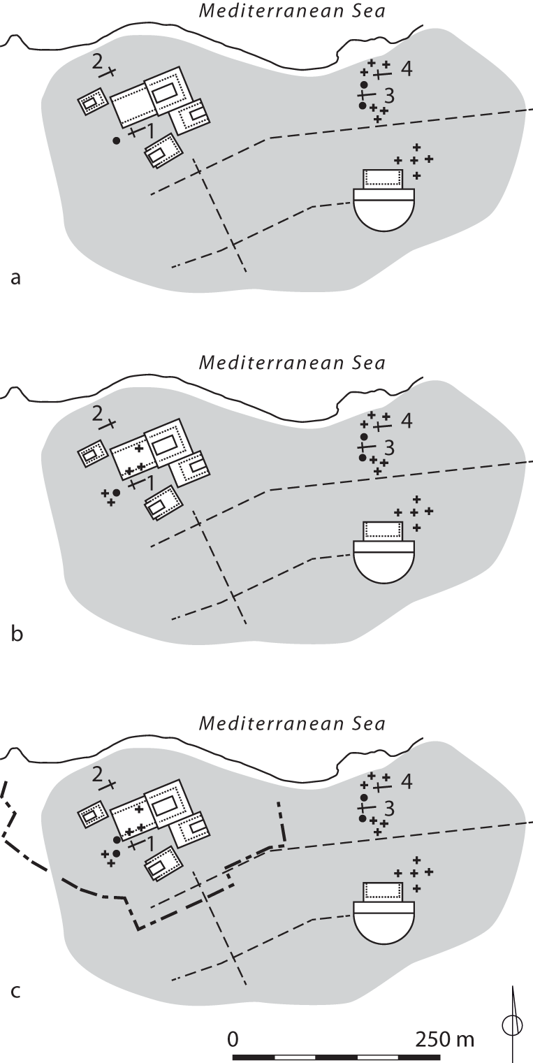
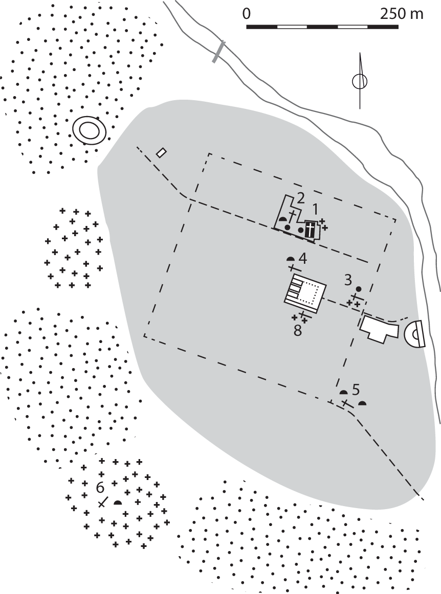
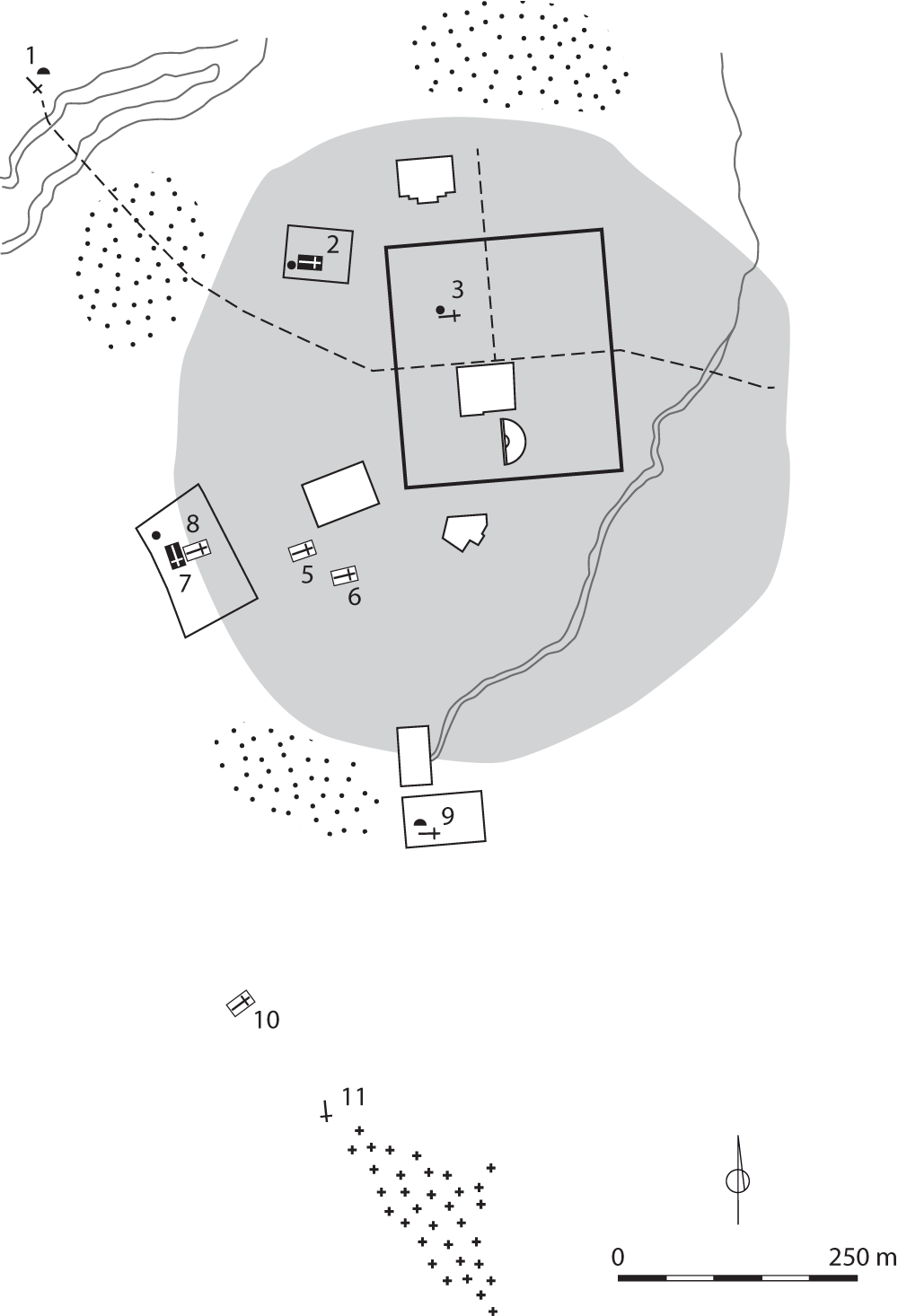
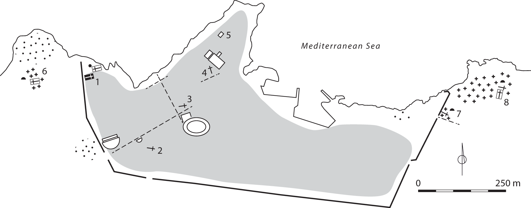
The topography of fourth-century towns is characterized by a paucity of information and a high degree of diversity (Michel Reference Michel, Lancel, Guédon and Maurin2005 about Numidia). In many cities, Christian builders selected prominent central locations, reusing or repurposing earlier sacred spaces. At Sbeitla (Figure 1a), the basilicas 1 and 3 were integrated into the city grid, with the latter erected over a former temple (Baratte et al. Reference Baratte, Béjaoui and Duval2014, 379–96).Footnote 3 A similar phenomenon is observed at Tipasa (3 on Figure 2a), where a basilica replaced a temple situated along a primary thoroughfare (Gui et al. Reference Gui, Duval and Caillet1992, 25–27, no. 3), and at Carthage, where the temple of Caelestis was famously converted into a cathedral, as recorded by Quodvultdeus (Liber promissionum et praedictorum Dei, 3, 38 (44); cf. Lepelley Reference Lepelley1979, 354). Although this transformation was legally possible at the beginning of the fifth century (Codex Theodosianus, 15, 1, 41), there is not much archaeological evidence to illustrate this change, especially when compared with the number of cities identified in North Africa.Footnote 4 At Sabratha (Figure 3a), several churches were inserted into the civic centre: one was located in proximity to the forum, and others were positioned behind the theatre within the built-up area (Ward-Perkins an Goodchild 1953, 7–10, 15–18; Bonacasa Cara Reference Bonacasa Cara1991). At Haidra (Figure 4a), basilica 5 was constructed towards the end of the fourth century or the beginning of the fifth century in an area that was probably inhabited (Baratte et al. Reference Baratte, Béjaoui and Duval2014, 321–22, no. 5). Comparable examples can be found in Djemila (4, Figure 5) and Hippo offers comparable examples, where basilicas were adapted to the dense urban fabric (cf. Figure 20). This adaptation reflects both spatial constraints and the symbolic importance of centrality (Gui et al. Reference Gui, Duval and Caillet1992, 100–101, no. 4; 346–49).
Sbeitla, plan of the town: a) fourth century; b) fifth century (author based on plan by J. Lenne in Duval Reference Duval1990, fig. 1).

Tipasa, plan of the town: a) fourth century; b) fifth century (author after Aupert Reference Aupert1974, pl. I).

Sabratha, plan of the town: a) fourth century; b) fifth century; c) sixth century (author after Di Vita et al. Reference Di Vita, Di Vita-Évrard, Bacchielli and Polidori1998, 148).

Haidra, plan of the town: a) fourth century; b) fifth century (author after Rocca Reference Rocca2012, 368, fig. 131).

Djemila, plan of the town in the fourth century (author after Février Reference Février1978, inset pl.).

While some churches were centrally located, others were constructed on the periphery – often along major roads or near cemeteries – indicating a complementary trend of expansion or reorganization. At Haidra (Figure 4), basilica 2 of Candidus was located along the eastern Gräberstraße, outside the town proper, while later constructions, such as the basilica 1 of Melleus, shifted back toward the urban core (Baratte et al. Reference Baratte, Béjaoui and Duval2014, 300–12). At Timgad (Figure 6a), the Christian complexes (2 and 7) were situated well beyond the Severan-era city (Gui et al. Reference Gui, Duval and Caillet1992, 265–67, no. 2; 274–78, no. 7). However, it is probable that they constituted a part of an urban fabric that remains to be fully understood. The episcopal complex at Djemila was also located on the southeastern outskirts, indicating the concurrent existence of both central and peripheral Christian spaces (1–2 on Figure 7).Footnote 5
Timgad, plan of the town: a) fourth century; b) fifth century (author after Courtois Reference Courtois1951, inset pl.).

Djemila, plan of the town in the fifth century (author after Février Reference Février1978, inset pl.). Basilica 5 was located ca. 300 m south-east of the city.

In addition, at this comparatively early period, there is a paucity of privileged tombs or repositories for relics. At Haidra (Figure 4), a relic box has been unearthed in basilica 5, which can be dated to the late fourth century at the earliest. Furthermore, martyrs’ tombs have been identified in the necropolis that developed from the fourth century onwards around basilica 2 of Candidus. The libation tomb in complex 7, located to the west of Timgad and known as the Donatist cathedral, is believed to be a later addition. In Tipasa (Figure 2), the presence of martyrs’ tombs has been attested in the vicinity of chapel 6 of Alexander, situated to the west, and the basilica 7 of Saints Peter and Paul, located to the east, beyond the wall (Gui et al. Reference Gui, Duval and Caillet1992, 32–37, no. 6–7). Additionally, a few tombs have been identified within basilicas 1 and 3 at Sbeitla (Figure 1). However, the martyrs’ tombs within basilicas 5 and 6 do not appear to predate the fifth century (Baratte et al. Reference Baratte, Béjaoui and Duval2014, 398–404, no. 6–7).
The majority of Christian basilicas that have been materially identified can be dated to the latter half of the fourth century, or even to the end of that century. At that time, the purchase of land for the construction of a church of reasonable size should not have presented any significant difficulties. J.-P. Caillet (Reference Caillet1993, 417) cites, for instance, a ratio of one to twenty in the price of land for the construction of a church in Constantinople and in the small town of Pinara in Lycia. However, the Christians who sought to develop a monumental complex around their basilicas required extensive land areas (Lassus Reference Lassus1965, 584–91).
The construction of Christian gathering places necessitated financial investments that were comparable to those made in major public buildings of Late Antiquity (Duval and Pietri Reference Duval, Pietri, Christol and Masson1997). Although some barbarian rulers contributed to the construction of such fortifications, their support was minimal and cities never financed construction projects (Lepelley Reference Lepelley1979, 373–74). In Rusguniae, for instance, Flavius Nuvel, a former official, and his family funded a building to house relics of the Cross (CIL, VIII, 9255 = ILCV 445 = ILCV 1822 = AE 2012, 1932; Lepelley Reference Lepelley1979, 384). In the local village of Ares, situated in proximity to Timgad, the contributions of the local populace are documented on a cippus (ILCV 1859 = AE 1894, 25 = AE 1894, 138). At Tigzirt, individuals were approached to contribute financially to the completion of the pavement mosaic (ILCV 1891–92). The financial contributions of bishops, however, are less readily delineated, as these individuals may have drawn upon personal wealth or received support from prosperous adherents. A notable illustration of this is provided by Alexander and his basilica at Tipasa (CIL VIII, 20903 = CLE 1808 = ILCV 1825 = AE 1922, 25 = AE 2016, 1832 = AE 2016, 1980). Regardless of the source of funding, bishops were regarded as euergetai. Church treasuries probably supplemented private donations and, despite the need to pool various resources, funding was generally available – the main obstacle was securing land.
Archaeological evidence suggests that by the late fourth century most towns had only one or two Christian places of worship. The cult of the martyrs remained limited, and cemeteries were mainly used for funeral banquets, allowing families to gather near the deceased. Of the sites mentioned, only Haidra (near basilica 2) and the outskirts of Tipasa functioned as Christian necropolises already in the early or mid-fourth century.
Christian religious practices
In North Africa, the feast of the martyrs resembled a local festival (uernacula sollemnitas), where people danced, feasted, and drank (Poque Reference Poque1968). It is evident that events such as Saint Leontius’ Day in Carthage or the vigil of the Natalis Martyris Cypriani on 13–14 September saw participation from both pagans and Christians (Augustine, Sermones 262, 2; 311, 5; Epistulae 29, 3). These night-time celebrations probably drew from pagan vigils, which Augustine attempted to suppress in Hippo (Epistulae 29). The practice of refrigeria, which refers to evening or nocturnal funeral meals, was permitted by the Church when held on relatives’ tombs. However, it was discouraged at martyr shrines (Augustine, Epistulae 22, 3–4; Rebillard Reference Rebillard, Brandt, Prusac and Roland2014a, 271–75). These gatherings often included music, zithers, and dancing (Cyprian, Epistulae 67, 6; Augustine, Sermones 311, 5–6), and were held in the proximity of commemorative mensae – funerary tables carved in relief, sometimes with a symbolic empty plate (Marrou Reference Marrou1949; Y. Duval Reference Duval1982, 541–42). Tipasa offers notable examples, including dining couches arranged beneath awnings and semicircular tables (Figure 8). One of these was dedicated to saints Rogatus and Vitalis (Lassus Reference Lassus1965, 605; Février Reference Février1986, 13–14; Rebillard Reference Rebillard, Brandt, Prusac and Roland2014a, 276–79). These arrangements date from the early fourth century and reflect both communal commemoration and complex negotiations between popular and official religious practice.
Tipasa, plan of the chapel 6 of Alexander and the funerary features (after Gui et al. Reference Gui, Duval and Caillet1992, pl. 34).

A distinctive aspect of these feasts was the reading of the Passio, which was typically positioned between the Gospel and the homily. Subsequently, the congregation was dismissed, except for the fideles. These readings were regarded as emotionally charged performances that substituted for forbidden secular spectacles (Augustine, Sermones 275, 1; 300, 1; Poque Reference Poque1968, 108–10). In order to counter the continued popularity of amphitheatre shows, which were still active in 399 (Codex Theodosianus, 16, 10, 17), Church leaders issued canons prohibiting entertainment on feast days (Registri ecclesiae Carthaginesis excerpta I canon. 61: ed. Munier Reference Munier1974, 197).
Nevertheless, as C. Lepelley observed, the Church struggled to create entirely new forms of sociability: martyr festivals did not always align with Christian liturgical rhythms. Instead, many continued to participate in civic banquets organised by local benefactors, which served to strengthen communal ties (Salvianus, De Gubernatione Dei, 6, 60–79 and 85–89; Inglebert Reference Inglebert and Busine2015, 228–29). The basilicas themselves became stages for festive interaction, especially among the urban plebs (Magalhães de Oliveira Reference Magalhães de Oliveira2012, 148–55). Popular Christianity emerged alongside lingering pagan customs, both criticized by more ascetic voices such as Augustine (Lepelley Reference Lepelley1987). Festivals conflicted with Christian ideals of bodily control: believers who took part often did so ambivalently, as if performing acts of penance (Dihle Reference Dihle1992, 329).
During this period, urban life was still structured around the pagan calendar, with Christian liturgical time gradually taking its place (Pietri Reference Pietri1976, I, 617–24).Footnote 6 Christian urban practice remained modest, with daily mass, vespers, and Sunday gatherings forming the basic rhythm, punctuated by Easter and winter feasts (Marrou Reference Marrou1985, 97–98; Rebillard Reference Rebillard2014b, 117–19). As outlined in the accounts of Saint Stephen’s miracles, celebrations include Easter, martyr commemorations, and Sunday observances (Hamdoune Reference Hamdoune and Meyers2006, 117: De miraculis Sancti Stephani, 2, 2, l, 265–68). Processions often began at dawn or dusk, making the Christian presence visible during the transitional hours.
Pagan landscape and religious practices
To understand the gradual disappearance of paganism, it is essential to consider the urban contexts in which the final processions in honour of the old gods took place. Although stratigraphic data remains limited, inscriptions indicate that temples continued to undergo restoration well into the mid-fourth century – as seen with the Capitol at Timgad (CIL VIII, 2388 = ILS 5554, dated 364–67).Footnote 7 Soon after, most temples were abandoned, though a few were adapted for civic purposes, as in Sabratha and HaidraFootnote 8 (Leone Reference Leone2013, 61–80), some were converted into churches (Duval Reference Duval1971b), and a small number were outright destroyed (Leone Reference Leone2013, 27–40; Sears Reference Sears, Lavan and Mulryan2011; Sotinel Reference Sotinel, Narcy and Rebillard2004).
Sources confirm that pagan festivals and processions remained visible in cities through the late fourth and early fifth century (Lavan Reference Lavan2021, 208–214). Augustine refers to such events in Madauros (390) and Calama (408) (Epistulae 17; 91, 8). However, outward expressions of pagan piety – like saluting imperial or divine statues – were abandoned by Christians (Carrié and Rousselle Reference Carrié and Rousselle1999, 414). These public rituals marked the last display of polytheism before Christianity became firmly embedded in the urban landscape. Yet, the secretive nature of Christian rituals, hidden even from catechumens, limited their physical visibility in contrast to the classical city’s architectural prominence (Caseau Reference Caseau, Bowersock, Brown and Grabar2001, 38).
Towards the Vandals: between continuity and oppression
By the fifth century, although the dating of Christian basilicas remains imprecise – often limited to broad chronological estimates – it is nonetheless possible to trace evolving patterns in the distribution of ecclesiastical buildings across urban landscapes. A small number continued to be built in central locations, often tied to earlier civic or religious monuments, while a growing number appear on the urban periphery, aligned with roads, necropolises, or zones of looser occupation.
Early fifth-century Christian topography
In the city centres, several churches reflect continued investment in monumental core areas. At Sbeitla (Figure 1b), the construction of basilica 2 – alongside basilica 1 as part of the cathedral complex – marked a significant Christian presence near the forum (Baratte et al. Reference Baratte, Béjaoui and Duval2014, 386–91, no. 3; cf. Figure 19). Nearby, basilica 4 was also erected in the vicinity of the forum, possibly reoccupying the site of an earlier civil basilica (Baratte et al. Reference Baratte, Béjaoui and Duval2014, 396–98, no. 5). At Tipasa (Figure 2b), a fifth-century basilica (4) was constructed directly above the earlier civil basilica at the city’s centre, while another building (8) is thought to have been settled on the site previously occupied by a monument built over the tomb of Saint Salsa (Gui et al. Reference Gui, Duval and Caillet1992, 27–29, no. 4; 37–44, no. 8). At Leptis Magna (Figure 9), basilica 2, built on the Forum Vetus, remains the most ancient known Christian structure in the city and similarly demonstrates a central placement (Ward-Perkins and Goodchild Reference Ward Perkins and Goodchild1953, 24–29).
Lepcis Magna, plan of the town in the fourth century (author after Di Vita et al. Reference Di Vita, Di Vita-Évrard, Bacchielli and Polidori1998, 51).

In the periphery of urban areas, new basilicas were increasingly integrated into marginal zones or along access routes. At Haidra (Figure 4b), basilica 4 – known as the ‘Vandal chapel’ – was built prior to the reign of Thrasamund, approximately 200 m from the city centre, in an area that was still inhabited during the Byzantine period (Baratte et al. Reference Baratte, Béjaoui and Duval2014, 318–20, no. 4). At Sbeitla basilica 5, situated along the south-eastern road and dedicated to Saints Gervasius and Protasius, and basilica 6 on the south-western outskirts – featuring a mosaic naming Saints Sylvanus and Fortunatus – both attest to the development of peripheral cult sites (Baratte et al. Reference Baratte, Béjaoui and Duval2014, 398–404, no. 6–7). At Timgad (Figure 6b), two modest churches were constructed before the Vandal conquest. The first of these was basilica 3 of Januarius, the only one integrated into the original grid, and the second was basilica 1, located off-centre along the road to Lambaesis (Gui et al. Reference Gui, Duval and Caillet1992, 263–70, no. 1, 3). In Djemila (Figure 7), basilica 5, erected prior to the mid-fifth century, was situated approximately 300 m east of the main cathedral complex, reflecting continued Christian expansion beyond the centre (Gui et al. Reference Gui, Duval and Caillet1992, 101–103, no. 5). In Tripolitania, a cemetery developed around basilica 1 at Sabratha (Figure 3b), while basilica 3 underwent modifications following the Vandal occupation (Ward-Perkins and Goodchild Reference Ward Perkins and Goodchild1953, 12).
The Christian presence was more pronounced in the Stadtbild of cities such as Sbeitla and Haidra,Footnote 9 where several basilicas clustered in the centre, though they were not always architecturally prominent. The situation was different for other reliefs and the positioning of buildings within the topography. In Tipasa (Figure 2b), P.-A. Février noted that the basilica of Alexander (6) was largely hidden by a nearby hillock. Similarly, the martyrium and basilica of Salsa (8) were visible from the southern road, but not from the port. The chapel of Saint Salsa followed funerary architectural traditions (Lander Reference Lander2017, 99–101) (Figure 10), whereas basilica 4, located within the civil basilica, occupied a key position on the decumanus maximus, overlooking the temple hill and Capitol (Duval et al. Reference Duval, Février, Lassus, Balty and Balty1972, 250; Février Reference Février1986, 13). Furthermore, the funerary landscape exhibited considerable variation across different cities, as evidenced by the contrasting examples of Tipasa and Timgad. Unfortunately, the available data does not permit a comprehensive reconstruction of this landscape (Février Reference Février1986).
Tipasa, reconstruction of the chapel of Saint Salsa (Grandidier Reference Grandidier and Duchesne1902).

Christian religious practices
There is currently a paucity of evidence to suggest the existence of a cult of saints within these buildings. The inscription in the ‘Vandal chapel’ at Haidra mentioning the relics of Pantaleon and Julian dates only from the late fifth century. The cult of Sebastian, referenced in building 8, was not introduced until the Byzantine period (Y. Duval Reference Duval1982, 44–48, no. 21, 650; Bejaoui Reference Bejaoui, Baratte, Béjaoui and Ben Abdallah1999, 216; Baratte et al. Reference Baratte, Béjaoui and Duval2014, 327, no. 8). Two churches dedicated to martyrs have been identified at Sbeitla. Furthermore, undated sarcophagi and tombs have been identified in basilicas 1, 4, and 8 (Figure 1b).Footnote 10 At Timgad (Figure 6b), basilica 1 on the road to Lambaesis contained a sarcophagus in the nave, which may have contained relics, as well as a crypt. In Tipasa (Figure 2b), only peripheral areas were dedicated to the cult of martyrs in the fifth century, without evidence of such cults in later periods. In contrast, there is no evidence of martyr cults in Tripolitania (Ward-Perkins and Goodchild Reference Ward Perkins and Goodchild1953, 5).
In relation to this cult, despite the Church’s tolerance of funeral banquets, a problematic pagan practice persisted, as evidenced by a libation tomb in Timgad (Marrou Reference Marrou1949). The sarcophagus was located in the nave of basilica 7, opposite chapel 8 (Figure 11). It featured a funnel-shaped opening in the lid, aligned with the deceased’s mouth. A small metal sieve nearby may have been used for pouring offerings – suggesting that the living continued to interact with the dead. This arrangement, which was prevalent throughout the empire, was associated with funeral meals that were intended not only to honour saints but also to ‘relieve the dead’ (Augustine, Epistulae, 22, 6).Footnote 11 Marrou associated this practice with the Donatists, based on Augustine’s complaints about feasts and orgies near Donatist basilicas (Epistulae, 29, 11), as well as Timgad’s known Donatist presence and an inscription mentioning Optat, possibly Bishop Optat of Thamugadi (AE 1939, 79 = AE 1967, 582a; Gui et al. Reference Gui, Duval and Caillet1992, 274–76).Footnote 12
Timgad, plan of the western Christian complex (7–8) known as the ‘Donatist cathedral’. Notice the possible entrances indicated by arrows; the tomb with libation tube is indicated in the nave of the basilica (after Ballu Reference Ballu1911, inset pl.).

The Church increasingly sought to regulate excessive or ambiguous practices. In his own writings, Augustine advocated a shift from entertainment to contemplation and from communal meals to the service of the Word (Epistulae, 22; 29; Sermones, 273, 8; Marrou Reference Marrou1949, 200–201). While feasts continued in basilicas or memoriae, the revellers were gradually excluded (Poque Reference Poque1968, 107). The celebrations also spread to cemeteries and streets, prompting ecclesiastical intervention (Hamman Reference Hamman1979, 331–32). Church canons urged moderation (Concilii Carthaginensis anno 397 canon. 29; Registri ecclesiae Carthaginesis excerpta I canon. 42; Fulgentius Ferrandus, Breviatio canonum, canon. 71), and prohibited the ‘saltationes sceleratissimorum’ – infamous dances in streets during martyrs’ feasts (Registri ecclesiae Carthaginesis excerpta I canon. 60). Augustine criticized the Donatists for allowing drunken processions involving nuns and Circumcellions (Contra epistulam Parmeniani, 2, 9, 19: ed. Finaert and Congar 1963, 309–10).
Restrictions towards pagans and the closing of temples
P.-A. Février (Reference Février1981) analysed this cultural shift in public ritual. Vigiliae, as described by Sidonius Apollinaris, were evening processions accompanied by candles and psalm-singing, intended to replace funeral banquets. Since funeral feasts were traditionally held during the night (e.g. ILCV 1570 from Satafis, dated 299), these vigils reappropriated the night for Christian liturgy. Sidonius’ account of the feast of Saint Just in Lyon (Epistulae, 5, 17) demonstrates that this transformation took nearly a century (Février Reference Février1981, 156).
By the early fifth century, the church authorities were increasingly restricting festivals. Augustine had condemned funeral banquets early on, and a canon eventually prohibited them (Registri ecclesiae Carthaginesis excerpta I canon. 42). In 405, Augustine praised Aurelius of Carthage for introducing sacrae vigiliae to counter pagan festivities at Saint Cyprian’s tomb (Sermones, 311). One such event in Uzalis celebrated the transfer of the relics of St Stephen: after a mass at the memoria of the martyrs, a procession moved towards the town church (De miraculis Sancti Stephani, 1, 2, 1, 6–9; Hamdoune Reference Hamdoune and Meyers2006, 117; cf. Saxer Reference Saxer1980, 251–52). A canon from 424–425 banned theatrical performances on feast days (Registri ecclesiae Carthaginesis excerpta I canon. 61), echoing Salvianus of Marseille’s lament that the faithful abandoned church services to attend the theatre (De Gubernatione Dei, 6, 38). Despite Augustine’s possible exaggeration, crowds probably gathered at basilicas during services. With more basilicas in cities, the Church aimed to lead the faithful to a more ascetic, supervised religion, replacing pagan rites with hymns and readings. Up to one hundred religious days per year (including Sundays) mobilized Christian communities and increased the spatial and social visibility of Christianity (Inglebert Reference Inglebert and Busine2015, 224).
However, this shift had led to some tension. Christian funeral processions sometimes clashed with pagan rituals. Pagan anger was provoked by Christian burials within city walls, which were seen as a violation of consecrated ground. However, by the fifth century, tombs were admitted into urban space (Caseau Reference Caseau, Bowersock, Brown and Grabar2001, 36–37; Leone Reference Leone2007, 145–48).
The prohibition of pagan worship in 399 and the directive to close temples (Codex Theodosianus, 16, 10, 17) did not eradicate polytheism. Urban elites often remained loyal to traditional cults, and the legal-political structures of the pagan city endured (Lepelley Reference Lepelley1979, 356, 371–76). Despite facing opposition from Christians, pagan processions continued into the fifth century. A canon prohibited Christians from joining such festivals (Registri ecclesiae Carthaginesis excerpta I canon. 60), and by the mid-century, sources suggest the processions ceased (Lavan Reference Lavan2021, 208–14). Fourth- and fifth-century conflict often centred on public space (Goddard Reference Goddard, Inglebert, Destephen and Dumézil2010, 132–34). The riots in Sufes (399) and Calama (408) were triggered by the destruction of a pagan statue and an attempt by Christians to cancel a calendar procession (Augustine, Epistulae, 50; 90; Lepelley Reference Lepelley1979, 355–57). Festivities were not banned as long as prohibited rites, sacrifices, or homage to a statue were not performed (Codex Theodosianus, 16, 10, 17, dated 29 January 399, and 16, 10, 18, dated 20 August 399 = Codex Iustinianus, 1, 11, 3). The focus of concern is on the gestures associated with the rites.
The Theodosian Code also protected temple buildings and decorations, even while banning their cult use (Leone Reference Leone2013, 40–46, 55–61). Pagan worship shifted to private homes, rural shrines, and natural sanctuaries, less restricted than urban ones (Caseau Reference Caseau, Bowersock, Brown and Grabar2001, 32). As Church control of urban spaces increased, pagans were pushed into public spaces for their rites, while Christians remained confined to churches and supervised processions.
The vandal shift
The Vandal conquest resulted in a century-long disruption of Catholic worship between 439 and 523 (Modéran Reference Modéran and Pietri1998b, 255–62). In Carthage, Genseric expelled bishops from churches (Victor of Vita, 1, 14, and 17). However, they refused to comply and, as ‘no place for praying or offering the sacrifice was conceded’ (Victor of Vita, 1, 22: ed. Moorhead Reference Moorhead1992, 11), proceeded to celebrate the rites in any available location, such as in public spaces. Bishop Quodvultdeus and others were compelled to leave Africa; Catholic funerary rites were subject to stringent regulation. Though some extra-mural sanctuaries remained accessible, conditions worsened after 457, when episcopal ordination was banned (Victor of Vita, 1, 29), sacred objects were confiscated, and all ‘spiritual assemblies’ were prohibited (Victor of Vita, 2, 1: ed. Moorhead Reference Moorhead1992, 24). Churches were closed, though persecution varied under Huneric, Gunthamund, and Thrasamund.
In Numidia and Byzacena, the measures were markedly different and less severe. During the period of Genseric’s rule, there was no confiscation of churches or regulation of worship. The provinces in question were only affected by the edict of 24 February 484, which imposed the closure of all Catholic churches and monasteries in Africa, the handing over of their property to the Arian clergy, and compulsory conversion to Arianism. Thrasamund resumed the exile of bishops, although partially it was reversed in 494. However, religious ceremonies were not forbidden. The Arian Church remained poorly documented but probably well-endowed through confiscations and royal patronage. Arian priests are attested in Carthage, Sicca Veneria, Tunuzuda, (Bulla?) Regia, and Gales, probably serving small communities of Vandal soldiers or civil servants. Despite persecution, most Christians remained Catholic. Catholicism was under serious threat only in Africa Proconsularis (Modéran Reference Modéran and Pietri1998b, 264–69). In Byzacena, the possible coexistence of Vandal and Catholic churches – as in Haidra – suggests two relatively peaceful communities, reminiscent of the earlier coexistence of Catholics and Donatists in Augustine’s time. True religious tolerance would not be proclaimed until 523.
Under Byzantine rule: Christianity flourishing
In tracing urban development chronologically, it is important to resist a purely cumulative interpretation. During the Byzantine period, though, the landscape of Christian worship in North Africa was shaped not only by the construction of new churches, but also by the active remodelling, expansion, and reuse of existing cult buildings – without evidence of abandonment of earlier structures.
Christian topography
Several sites illustrate the continued use and modification of earlier buildings. At Haidra (Figure 12), all basilicas remained in use, with alterations recorded in basilicas 2 and 5, while basilicas 1, 4, and building 8 are known to have contained relics (Baratte et al. Reference Baratte, Béjaoui and Duval2014, 300–27).Footnote 13 At Sbeitla (Figure 13), significant remodelling affected all six main basilicas (1–6), while basilica 8 may have still functioned before being converted into a workshop in the seventh century. Once again, all the places of worship were occupied.Footnote 14 At Djemila (Figure 7), the mosaic of Bishop Cresconius – possibly the same figure who attended the Council of Constantinople in 553 – was added to basilica 2, and the cemetery at basilica 4 underwent alterations into the seventh century. At Timgad (Figure 14), Byzantine-phase modifications affected basilica 3 in the city centre, the major complexes 2 and 7 on the western periphery, and chapel 8 – the so-called Donatist cathedral – which was enlarged during this period. The dating of the two small chapels (5 and 6), located near the Capitol (Gui et al. Reference Gui, Duval and Caillet1992, 271–74, nos. 5–6) and the church (11) in the southern necropolis (Gui et al. Reference Gui, Duval and Caillet1992, 284–86, no. 11), is uncertain. The later chapel of Gregory the Patrician (10), dated between 641–647, reflects a long Christian activity at the site (Gui et al. Reference Gui, Duval and Caillet1992, 282–84, no. 10). In Tipasa (Figure 15), the basilica of Salsa (8) was rebuilt in the seventh century, a new small basilica (2) was erected in the city centre, and basilica 1, located to the west, was reoccupied (Gui et al. Reference Gui, Duval and Caillet1992, 21–25, nos. 1–2). In Tripolitania, basilica 1 at Sabratha was also remodelled (Figure 3c).
Haidra, plan of the town in the sixth century (author after Rocca Reference Rocca2012, 368, fig. 131).

Sbeitla, plan of the town in the sixth century (author after J. Lenne in Duval Reference Duval1990, fig. 1).

Timgad, plan of the town with Christian buildings from the sixth century (author after Courtois Reference Courtois1951, inset pl.).

Tipasa, plan of the town in the sixth century (author after Aupert Reference Aupert1974, pl. I).

New churches were also constructed, often by reappropriating earlier structures or in conjunction with Byzantine fortifications. At Haidra (Figure 12), basilicas 3 and 7 were built within the Byzantine citadel, while basilica 6 was constructed some 200 m to the east (Baratte et al. Reference Baratte, Béjaoui and Duval2014, 312–18, no. 3, 324–26, no. 7). At Timgad (Figure 14), a small church (9) was installed within the fortress, highlighting the strategic integration of worship space with military infrastructure (Gui et al. Reference Gui, Duval and Caillet1992, 280–82, no. 9). In Leptis Magna (Figure 16), the transformation was particularly notable: basilica 1 was installed in the Severan civil basilica – probably under Justinian (Procopius, De Aedificiis, 6, 4, 4–5) – while basilica 3 was built west of the Severan Forum, and basilica 6 reused the former Small Nymphaeum on the Via Colonnata. A baptistery was also added to the Forum Vetus (Ward-Perkins and Goodchild Reference Ward Perkins and Goodchild1953, 22–24, 27–31, 82). The dating remains uncertain for basilica 5, located on the eastern breakwater, and for another baptistery near the former temple of Jupiter Dolichenus.
Lepcis Magna, plan of the town in the sixth century (author after Di Vita et al. Reference Di Vita, Di Vita-Évrard, Bacchielli and Polidori1998, 51).

Martyrs’ tombs and relics were widespread, and in some cases newly erected during the Byzantine period. At Haidra (Figure 12), tombs have been identified in six of the seven basilicas securely dated to this period. Reliquaries and martyrdom inscriptions also date to the Byzantine period, even in buildings erected earlier, with the possible exception of some relics from a fourth-century phase in basilica 2. A similar pattern can be seen at Sbeitla (Figure 13), where reliquaries from the Byzantine period were in basilicas 2, 4, and 5, while a mosaic naming saints was discovered in basilica 6. Undated tombs and sarcophagi have also been discovered in basilicas 1, 3, and 8. By contrast, Timgad (Figure 14) offers fewer examples: a privileged tomb has been identified in basilica 11, possible relics in the nave of basilica 1, and seventh-century reliquaries may have existed in church 9 within the fortress. Urban churches at Tipasa, unlike those at Carthage, have no known tombs – suggesting a localized practice of intramural burials (Duval Reference Duval2006, 199). In Tripolitania, early sixth-century tombs may be associated with basilica 1 at Sabratha (Figure 3c), while others have been found at Leptis Magna (Figure 16) in the cemetery adjacent to basilica 3, and probably pre-Byzantine ones near basilica 2.
Christian religious practices
Although funerary banquets had lost their universality, they may have persisted – especially as part of martyr and saint cults, sometimes within churches themselves (Duval Reference Duval2006, 152–53). The increasing importance of relics in churches reflects this development. The Byzantine period (Duval Reference Duval2006, 123–24; cf. Modéran Reference Modéran and Pietri1998a) was marked by the introduction of Eastern saints’ cults, whose relics were brought to North Africa. In inland towns such as Sbeitla, the relics of Triphon, Gervasius, and Protasius were kept in the sixth century in basilica 5 (Baratte et al. Reference Baratte, Béjaoui and Duval2014, 398–402, no. 6), while in Haidra (Figure 12) the relics of Pantaleon and Julian were kept in basilica 4 (Baratte et al. Reference Baratte, Béjaoui and Duval2014, 318–20, no. 4), and those of Isidore and Sebastian in building 8 (Bejaoui Reference Bejaoui, Baratte, Béjaoui and Ben Abdallah1999). However, this was not a case of orientalization, but rather the result of renewed ties with the Eastern Empire. At the same time, growing connections with Italy led to the introduction of Roman and Italian saints (Modéran Reference Modéran and Pietri1998a, 711–12).
This relocation of relics – often placed directly under altars – reflected a broader imperial trend dating back to the fourth century. It did not involve building sanctuaries on existing tombs or martyrdom sites, but rather creating new sacred spaces incorporating relics (Sotinel Reference Sotinel2005, 419–25). Some tombs continued to be located in cemeteries, as in Tipasa, in privileged areas within churches, or in memoriae adjoining basilicas. Veneration could also take place on cenotaphs or through inscribed lists of names, as seen in basilica 6 at Sbeitla (Figure 13), where Sylvanus and Fortunatus were commemorated (Baratte et al. Reference Baratte, Béjaoui and Duval2014, 402–404, no. 7), and in basilica 2 at Haidra (Figure 12) with its ‘martyrs’ chapel’ (Baratte et al. Reference Baratte, Béjaoui and Duval2014, 307–12, no. 2).
Surviving paganism and other religious practices
Despite growing ecclesiastical control, public celebrations remained lively. Until the sixth century, calendar processions still took place in the streets (Lavan Reference Lavan2021, 214). A canon of the Breviatio canonum, issued in North Africa between 523 and 546–547, prohibited Christians from participating in pagan festivals: ‘ut nullus cum paganis festa celebret’ (Fulgentius Ferrandus, Breviatio canonum ecclesiasticorum, 187: ed. Munier Reference Munier1974, 303). This suggests that such events remained common, often involving dancing and drinking – practices already condemned by Augustine a century earlier, who noted their appeal even after Mass (Dolbeau Reference Dolbeau1996, 75–76: Augustine, Contra Faustum Manichaeum, 20, 4; Sermones, 196, 4).
Tensions with the Jewish community also continued. Three canons from the Breviatio canonum outlined prohibitions against Jewish religious customs (Fulgentius Ferrandus, Breviatio canonum ecclesiasticorum, 181, 185, 186: ed. Munier Reference Munier1974, 302). For example, Christians were forbidden to receive unleavened bread from Jews during Passover. This is reminiscent of canon 69, which forbade celebrating Easter ‘with the Jews’ – that is, on the same calendar date (Fulgentius Ferrandus, Breviatio canonum ecclesiasticorum, 69: ed. Munier Reference Munier1974, 293), a longstanding practice. These restrictions, though initially adopted in fourth-century eastern councils, were apparently still relevant to the African Church in the sixth century. T. Villey (Reference Villey2019, 76–78) suggests that the continued presence of Judaizing Christians – well attested during Augustine’s time – justified their enforcement a century later.
During this period, pagan temples were increasingly subject to material reuse, particularly for the construction of enclosures (Leone Reference Leone2013, 31–32, 64). However, it is difficult to assess how long these structures had remained visible in the urban landscape. Limited evidence on the cessation of maintenance or timelines of abandonment hinders precise evaluation. Nevertheless, it seems likely that, by this time, the city fortifications had become the most prominent features of the built environment (cf. Leone Reference Leone2013, 80–82).Footnote 15
A new topography of devotion
The delineation of a Christian topography of the cities of Late Antique North Africa must be undertaken with a meticulous attention to the persistence of the city structures of the Early Roman period, and in particular the pagan temples. Concomitantly, the question of religious practices must be addressed in order to restore a ‘lived urban religion’ that is not confined to a static urban landscape.
It is important to note that the implantation of churches on temples was not the norm, neither in North Africa nor in any other part of the empire (Cantino Wataghin Reference Cantino Wataghin1999 on the West; Severin Reference Severin, Brands and Severin2003 on the East). Rather than a persistence in the positioning of places of worship, there was a remodelling of religious topography. In the West, from the fourth century onwards, Christian buildings were erected in different locations from pagan temples, which helped to create a new ‘topography of devotion’ (Ward-Perkins Reference Ward-Perkins, Brands and Severin2003, 286–87; expression from Salzman Reference Salzman, Lätzer-Lasar and Urciuoli2020). While pragmatic factors, particularly the scarcity of available land in densely populated areas, undoubtedly played a role in this shift, it is important to acknowledge the religious underpinnings as well. Christianity, in its essence, prioritized the congregation of its adherents, exhibiting no inherent predilection for the location of the place of worship. This approach emulated the model of the synagogue, as opposed to the pagan sanctuary, signifying a house of the congregation rather than a house of the god. Consequently, the concept of a ‘sacred’ place, in the pagan sense of the term – which belonged to the divinity – was not established. However, the widespread Christianization of the fifth and sixth centuries resulted in considerable alterations to the urban topography, giving rise to a new ‘geography of the sacred’. A notable development was the emergence of pilgrimages to relics, which attracted significant numbers of devotees. In distinction to paganism, the sacred geography of Christians was characterized by its mobility (Caseau Reference Caseau, Bowersock, Brown and Grabar2001, 39–43). The centres of Haidra (Figure 12) and Sbeitla (Figure 13) are notable examples of this phenomenon, with numerous basilicas in close proximity and the possession of relics. In Tipasa (Figure 15), conversely, three churches (2–4) were located in the old centre, yet the tombs did not occupy these places of worship and remained confined to the suburbs, as did the tombs and relics of the martyrs. It was on the outskirts that religious activity was likely to be greatest on feast days, with processions leaving the centre, as witnessed at Uzalis. A similar situation was observed in Timgad, particularly during the Byzantine period (Figure 14), when the later structures were constructed to the south of the town (cf. Lamare Reference Lamare2022, 264–66). However, the absence of evidence pertaining to the veneration of martyrs in the cities of Tripolitania hinders our capacity to evaluate the nature of religious activities that may have transpired. The development of Christian necropolises in proximity to pagan burial grounds, or their establishment around martyrological cult centres, has been identified as a pivotal factor in understanding the dynamics of the cult of the dead (Duval Reference Duval and Trousset1995).
The substantial presence of basilicas in the very centre of certain medium-sized towns, such as Haidra and Sbeitla, gives rise to a number of inquiries regarding the utilization of these structures. A cathedral complex, for instance, might host ceremonies exclusively on designated feast days, while the presence of particular relics or edifices dedicated to diverse strands of Christian worship would result in specific uses. However, the existence of several Catholic basilicas necessitates an explanation of their utilization according to residential neighbourhoods. The issue manifests in a distinct manner in a large city (Saxer Reference Saxer1989, 921–22 on Rome) compared with a medium-sized town. Even within a reasonably compact urban area where access to places of worship is relatively straightforward, it is crucial to recognize that the establishment of a basilica in a specific area can be perceived as a significant opportunity with regard to various forms of connectivity. This encompasses social relations beyond the familial unit, professional contacts, and opportunities for discussions that may involve benevolent, or less so, discussions about shared acquaintances, extending far beyond the scope of spiritual interactions. The Church, and the place of worship close to the home, could also provide help for the poor in the neighbourhood, which was very useful in an empire that practised euergetism but not charity (Urciuoli Reference Urciuoli2020, 30–33).
Churches in the cityscape
This topographical approach, which requires careful consideration, is also a modern approach; to understand how the city is perceived by contemporaries, we need to think at human eye level. The issue of the visibility of certain basilicas in the urban landscape has already been addressed. In addition, the appearance of the building itself and the distinction it boasts must be examined.
In the domain of urban planning, a correlation has been postulated between cathedral complexes and colonnaded thoroughfares within the Eastern Mediterranean region. This hypothesis suggests that the presence of such streets might have engendered an architectural milieu conducive to festivity, reminiscent of that observed in the third and fourth centuries (Jacobs Reference Jacobs2014). Notwithstanding the prudence demanded in interpreting such phenomena, the scenario in the Western regions, notably North Africa, appears less remarkable. While Tebessa and Djemila each feature a cathedral complex with a colonnaded roadway (Jacobs Reference Jacobs2014, 278), other examples of both large ensembles and modest churches have more discreet entrances (Duval Reference Duval and Duval1989, 385). In addition to the plan, it is important to look at the elevations of the facades. At Haidra, basilica 3 featured a portico supported by three arches, with two columns on either side (Figure 17), while basilica 7 boasted a simple façade, comprising a central doorway and two side doors that opened onto a narrow street (Figure 18). In instances where temples were reused, as evidenced at basilica 3 at Sbeitla, the external appearance of the building remained unaltered by the presence or absence of the original façade portico opening onto the street. In the event of its disappearance, the building’s perimeter wall would feature three unadorned doors, providing access to a courtyard (Figure 19). It is also notable that cathedral complexes were typically surrounded by a wall that could only be accessed through a limited number of small openings. This characteristic is evident at Tebessa and Sbeitla (Figure 20), as well as in the two complexes at Timgad (Figure 11) and at Hippo (Figure 21). Despite their substantial size, the plainness of their facades, the absence of decoration and inscriptions, and their integration into the dense urban fabric of some cities, did not render Christian basilicas conspicuous features of the cityscape. Their architectural form and roofing failed to distinguish them from civil basilicas, and in the highly stereotyped representations of cities in Late Antiquity, the Christian church was barely distinguishable without the inscription that sometimes identified it. Besides, according to Augustine (Sermones, 337: Gauthier Reference Gauthier, Brogiolo and Ward-Perkins1999, 204–207), the outward appearance of churches was not a priority for believers. Furthermore, there is no extant documentation of bell towers in North Africa, with the earliest evidence of such structures in Europe dating to the sixth century (Neri Reference Neri2012). It is possible that the introduction of the dome in the Byzantine period had a more striking visual effect when it was used. The monumental mass that a building could represent needs to be assessed in context, depending on whether the urban environment was already occupied by large buildings, as in Rome, or was just a modest town with wooden buildings, for example (Cantino-Wataghin Reference Cantino Wataghin, Bowden, Gutteridge and Machado2006, 301–302; Thélamon Reference Thélamon, Thélamon and Boudon2006). The establishment of the cathedral complex of Aradi (Sidi-Jdidi), Tunisia, in the ‘upper’ town was perhaps as much the result of the availability of land as the search for visibility (Ben Abed et al. Reference Ben Abed-Ben Khader, Fixot and Roucole2011, 354).
Haidra, basilica 3: a) plan of the remains; b) axonometry (J.-C. Golvin in Baratte et al. Reference Baratte, Béjaoui and Ben Abdallah1999, 74, fig. 10 and 180, fig. 144).

Haidra, basilica 7: a) plan of the remains (J.-C. Golvin in Baratte et al. Reference Baratte, Bejaoui and Ben Abdallah2009, fig. 7); b) restored view (J.-C. Golvin in Baratte et al. Reference Baratte, Bejaoui and Ben Abdallah2009, 52, fig. 57); c) view of the building after excavation (F. Baratte in Baratte et al. Reference Baratte, Béjaoui and Duval2014, 325, fig. 305).

Sbeitla, axonometry of basilica 3 (J.-C. Golvin in Duval Reference Duval1971b, 274–75, fig. 7–8).

Sbeitla, axonometry of the cathedral complex (basilicas 1–2) (G. Hallier in Duval Reference Duval1971a, 297, fig. 335).

Hippo Regius, restored view of the cathedral complex (J.-C. Golvin. By courtesy of the author).

While the building cannot be identified as a Christian basilica, it is clear that the practices surrounding this structure influenced its perception at the time. The imageability of the city, as theorized by K. Lynch, sheds light on this aspect. If we accept that the basilica was not a notable feature of the urban landscape, then it does not fall into the category of landmarks that are visible and recognizable from a great distance, unlike the fortifications, as mentioned above. Instead, it would be considered a local landmark, which is what the inhabitants interviewed by Lynch referred to more frequently (Lynch Reference Lynch1960, 78–83). Therefore, the basilica was not universally referred to, but its meaning was influenced by people and events, which helped to shape its representation in the minds of passers-by and, consequently, in the image of the city: the practice modified the image.
Practices shaping the city
In fact, the visibility of religious worship was not solely material; practices that transcended the confines of designated places of worship, such as temples or churches, contributed to the pervasive presence of religion in the city. Churches, as places where people could gather even outside of services and celebrations, created new social spaces (cf. Guyon et al. Reference Guyon, Baratte, Cantino Wataghin, Heijmans, Brandt, Fiocchi Nicolai and Castiglia2016, 28), on different days and at different times from those usual in pagan religion. The suburbs also experienced an impact, with their cemeteries and the presence of martyrs’ tombs or relics (cf. Cantino Wataghin Reference Cantino Wataghin, Lavan and Bowden2003, 243–45). On a daily basis, the Christian population was not easily identifiable (Rebillard Reference Rebillard2014b, 116–17). Tertullian’s third-century Apologeticum (42, 1) offers a testament to this, stating: ‘(…) we are human beings and live alongside of you, men with the same ways, the same dress and furniture, the same necessities (…)’. Concurrently, the Christian who engages in the social fabric of the city aspires to do so with respect for their religion: ‘I do not bathe at dawn on the Saturnalia – I do not wish to lose both night and day; but I do bathe at the proper and healthful hour (…). Nor do I recline to eat in public at the Liberalia (…)’ (42, 4–5: ed. Glover Reference Glover1931, 191). While a cult may have possessed a significant sanctuary and conducted public rituals with little impact on the population, it is equally possible that a cult may have remained largely hidden yet attracted considerable popular interest through the activities of its members seeking to recruit. Within the context of Christianity, itinerant preachers were to be found throughout the empire, including in North Africa as Augustine criticized them (De opera monachorum, 21, 24; 23, 28; 28, 36: Pottier Reference Pottier, Moatti, Kaiser and Pébarthe2009, 230). Even in the absence of public attention, conversion was the ultimate aim of the preachers (Beard et al. Reference Beard, North and Price1998, 271–76).
However, the non-daily but recurring routines were different: religious festivals that were repeated as the liturgical calendar changed from pagan to Christian, as mentioned above. In this sense, the city underwent a transformation as a result of the change in its practices. In this context, it may be beneficial to refer to Henri Lefebvre’s theories, as he emphasized that practices and lived experience were crucial in shaping the city, just as much as monuments or institutions. According to his three concepts, we can consider that the ‘conceived space’ of the city underwent less change during Late Antiquity than its ‘lived space’ and ‘perceived space’ (Lefebvre Reference Lefebvre1972, 38–39). Another theorist of everyday life, and more broadly of urban practices, Michel de Certeau (et al. 1994, 201–204) compares gestures to ‘archives of the city’ that rearrange urban space: the disappearance of certain pagan religious gestures, in favour of others that are now Christian, has also contributed to transforming the city over the centuries.
Conclusion: urban form vs. practice
Let’s think about the modern town. Most villages in France or Italy are organized around a church and sometimes a surrounding cemetery, both inherited from medieval town planning. The church, with its distinctive bell tower, is a prominent feature of the town’s layout, and cathedrals, with their monumental presence, further accentuate the religious significance of these spaces. Is this enough to assert that the city is Christian, that it feels Christian, or that it is perceived as Christian? Instead, it is the sound of the bells, the gathering in the squares for weddings, funerals or Sunday masses that mark the presence of Catholic Christian worship in the city.
From a different perspective, that of a Christian European visiting North Africa, the answer is also not so clear cut. Most towns have a mosque, some of them modern. However, it is not immediately obvious when you enter the town, despite the presence of its minaret. The calls to prayer that punctuate the day, or the presence on the street of many men in djellaba, gathering at places of worship for Friday prayers, make religion much more visible. The cityscape in the centre of Constantine, Algeria, is more reminiscent of a colonial city, with its neo-classical theatre and post office or, close to the Place des Martyrs, the neo-Moorish Hôtel Cirta. On the other hand, a few minutes before Friday prayers, the gradual closure of all the shops in the city centre, the movement of dozens of people towards the surrounding mosques at the call of the muezzin, and the silence that breaks with the city’s usual high population density, make the practice of the Muslim religion a sensitive matter.
This is the same problem of judgement that orientalists encountered in their pioneering studies of the medieval Arab urban phenomenon. The Arab city was described as a ‘Muslim’ city, whereas the medieval European city was not described as ‘Christian’ (Raymond [1995] Reference Raymond, Biget and Hervé2014, 29–30). Despite the presence of common characteristics in the urban structure of medieval towns, extending from the Maghreb to Iran, these communities were not defined by their affiliation to Islam. Instead, it was the community characteristics and the social and professional life of the populations attached to institutions of a Muslim nature that were the defining factors. The designation of a town as ‘Muslim’ is predicated solely on the presence of a Muslim population (Raymond [1995] Reference Raymond, Biget and Hervé2014, 39).
But this concerns our point of view on past periods. In any case, people did not think they were living in a ‘Christian city’. Awareness of the changing urban religious landscape was probably very low. At the very most, the experience of building a new basilica might have made people sit up and take notice. But to perceive a change requires knowledge of a previous state of affairs that was not accessible to the majority of the population: at most, family memory could be eighty years old (Assmann Reference Assmann1995, 127). Not only do we have to question the notion of a ‘Christian city’, which is based primarily on two-dimensional topography to characterize the state of a city in Late Antiquity,Footnote 16 but we also have to consider that contemporaries themselves did not refer to it in this way.
The medium-sized towns of Late Antiquity in North Africa underwent significant changes during the transition from paganism to Christianity and the following centuries. These changes included alterations in the utilization of urban space, the abandonment of ritual gestures, the transformation of daily habits, the reappropriation of public spaces, the relocation of focal points for gatherings, and the recreation of places of devotion (cf. Monfrin Reference Monfrin and Pietri1998, 982–86; Sotinel Reference Sotinel, Narcy and Rebillard2004, 40–41). It is precisely this comprehensive analysis that allows us to move beyond the conventional study of topography and urban landscapes to reconstruct the practices and atmospheres that comprised the ‘Christian city’ or, more broadly, the Late-Antique city, with its distinct local characteristics.