Despite the fact that such eminent historians as Richard Trainor and Simon Gunn have, in recent years, reasserted the centrality of the middle classes to an understanding of the development of modern urban Britain,Footnote 1 the history of the middle classes remains incomplete. Understandably, most works that have examined the middle classes have tended to focus on the ‘city’ or neighbouring industrial conurbations. Whilst county towns and established market towns have received some limited attention, centres generally removed from the major concentrations of industry and commerce have yet to be studied in any depth. Equally, being the most immediately apparent in the urban context, the ‘bourgeoisie/proletariat’ relationship has tended to predominate in many studies. The aim of this study is to begin to fill some historiographical gaps by focusing on relations with the landed classes in an urban context well removed from the more widely studied examples. The case of the north-east Lincolnshire port of Grimsby is one such instance that raises a number of potential issues to be analysed in the context of R.J. Morris' now famous assertion that British towns were ‘substantially the creation of their middle class’.Footnote 2 To date, Grimsby has received little attention in academic terms, despite the fact that it was, by 1900, the largest and richest urban centre in Lincolnshire, having surpassed Lincoln in this respect in the 1870s.
Context
Local studies undertaken to date point to relations between the landed elite and an expanding middle class being subject to a considerable level of regional diversity. According to T.J. Nossiter, many industrial towns in the north-east continued to be subject to landed influence well into the nineteenth century though its extent and nature depended upon the ability of individual landowners to adapt to the changing circumstances of post-reform urban politics.Footnote 3 In a number of cases, the active involvement of the landed classes in the coal industry appears to have been a significant factor serving to perpetuate landed power whilst ‘inhibiting the development of an independent industrial elite’, consequently ‘an independent urban society . . . was slower to develop among the north-eastern middle classes than in Yorkshire or Lancashire’.Footnote 4 J. Garrard's study of three industrial towns in Lancashire tends to support this assessment and has relatively little to say about relations with the landed classes. Bolton, Rochdale and Salford appear to have been firmly under the control of middle-class proprietors whose major concern in class terms was the mediation of relations with a large urban workforce. Garrard is clear about the extent to which the nineteenth-century middle classes struggled to extend their influence beyond municipal boundaries but in terms of urban hegemony, the landed classes receive little attention beyond the obstruction of external developments such as Rochdale's sewerage scheme or Bolton's municipal expansion.Footnote 5
There is little doubt that many elements of the nineteenth-century middle classes defined themselves in terms of confrontation with a hostile rural-based, anti-urban aristocracy. Footnote 6 David Cannadine points to commentators such as Robert Vaughan, for whom the conflict was both widespread and readily apparent. However, analysis based on unmitigated conflict is at best partial at worst misleading. Cannadine refers to a ‘love–hate relationship’ in which the landed classes were both ‘beneficiary and victim of urban growth’ whilst the urban middle classes were on the one hand successful in eroding ‘landed dominance’ on the other remained ‘diffident and divided in their attitude toward the patrician’.Footnote 7 The case of Grimsby will further illuminate this diffuse and dichotomous relationship.
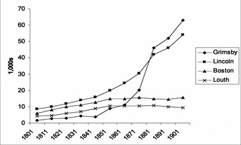
At the beginning of the nineteenth century Grimsby was little more than a decayed market town. Figure 1 details the nature of Grimsby's growth in comparison with a cross-section of other Lincolnshire centres: the county town, an inland port and a major market town. Socio-political relations in the early nineteenth century were rooted in Grimsby's long pre-industrial history, which mirrored, in many respects, that of many ancient, unreformed boroughs. As a port, it had flourished through the medieval wool trade before entering a period of protracted decline in the latter part of the fourteenth century.Footnote 8 On the basis of that commercial success, the town secured a succession of charters resulting in a long, if frequently dubious, ‘tradition’ of independent municipal identity.Footnote 9 By the mid-eighteenth century, the port's maritime trade had all but vanished and the population had declined to fewer than a thousandFootnote 10 and the 80 or so freemen who constituted the parliamentary electorate ensured the borough's reputation as one of the most corrupt in England.Footnote 11 In the latter half of the eighteenth century, two distinct patrician elements predominated. The Clayton/Tennyson family, minor Tory landowners whose position in the locality has been ascribed to ‘bribery, bullying and corruption’, were politically pre-eminent between 1727 and 1772.Footnote 12 The Yarboroughs of Brocklesby HallFootnote 13 became prominent after the consolidation of estates in the hands of Charles Anderson-Pelham in 1763 and by 1794 they were amongst the most substantial landowners in England.Footnote 14 In the early nineteenth century the reformist Whig, Baron Yarborough, was Grimsby's leading property ownerFootnote 15 and the associated levels of patronage, favour and licence were sufficient to ensure the loyalty of the corporation without recourse to overt bribery to which they were apparently opposed,Footnote 16 which in turn generally ensured control of parliamentary representation.Footnote 17
Comparative growth in four Lincolnshire towns
Source: Parliamentary Papers, Population, 1841–1901.

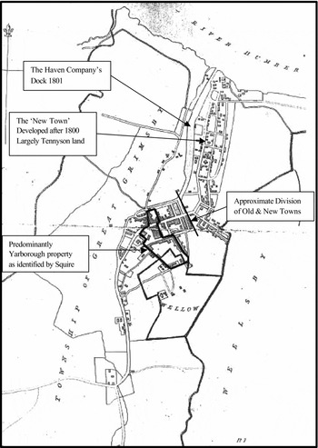
Yarborough land holding in Grimsby 1818–19 (superimposed on OS map of 1831)
In a series of letters to his employer John Squire, a Tennyson estate manager, detailed the extent of the Yarboroughs' property in the Old Town and correlates this to their political dominance in this area. Squire observed that the Yarboroughs were continuing to acquire property so their holdings are likely to have increased by 1831. The ‘New Town’ extended north from the medieval centre alongside the Haven Company's new dock. Tennyson's predominance as landlord in this area did not counterbalance Yarborough's presence in the Old Town and Squire warned that this imbalance was likely to deteriorate as the fortunes of the Haven Company declined.
Source: C.J. Cooper, Electoral Politics in Grimsby, 1818–1835 (Oxford 1987), 158–72.

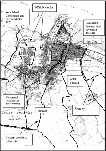
Grimsby 1881 indicating approximate property holdings of the major landowners
The Yarboroughs were the major beneficiaries of the 1827 Enclosure Act which extended their estate to over 40% of land in the Borough. The MSLR's property was also substantial. The Corporation and the Freemen were the other principal landlords, the bulk of the Heneage estate being in the neighbouring parish of Clee with Weelsby which was absorbed in to the County Borough in 1891. Development of Heneage land within the Borough consisted of high status housing and included asubstantial public park whilst that outside the borough contained a mixture of more modest middle-class and working-class accommodation. Reflecting their commercial and political inactivity in the latter decades of the nineteenth century, Yarborough land remained largely undeveloped for housing purposes until the 1920s.
Source: A. Dowling,The Corporate Landowner in Town Development (Hull, 1997); Ranger, Report to the General Board of Health of a Parliamentary Inquiry into the Health of Great Grimsby, 1849.

Although the population of the borough had recovered to a little over 1,500 by 1801, such middle-class elements as existed amounted to a handful of professionals and ‘dealers’ typical of a small town.Footnote 18 At this point it was patrician rivalry rather than the action of an emergent middle class that was the catalyst for development, the opening of the Grimsby Haven Company's new dock in November 1801 representing the first concerted attempt to revive the borough's fortunes. Its real significance, however, was political rather than economic. The Haven Company was substantially a Tennyson/Clayton led initiative and can only be understood in the context of their relationship with the Yarboroughs.Footnote 19 Although the absence of any effective transport infrastructureFootnote 20 ultimately condemned the project to failure, it was hugely popular in the borough enabling the Tennysons to affect some redress with regard to their declining political position. For their part, the Yarboroughs appear to have been distinctly ambivalent though they could not be seen to oppose so popular a project and emerged as one of the company's major shareholders.Footnote 21
Social structure and patrician rivalry
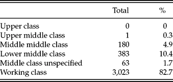
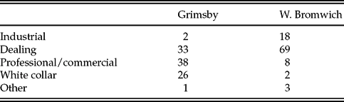
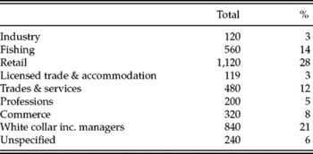
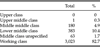
The population of the borough grew steadily though unremarkably through the first three decades of the nineteenth century followed by a period of very rapid growth in the second half of the century. Identification of a middle class in any context is notoriously problematic and for the purposes of this study, the social status and functional-group schemes used by Trainor in Black Country Elites are employed. On this basis a clearly identifiable middle class was present in Grimsby by 1851, accounting for almost 18 per cent of the population (see Table 1).Footnote 22Table 2 illustrates the ‘functional-group’ composition of Grimsby's middle class in comparison with that of West Bromwich, one of the towns in Trainor's study which, in terms of growth, corresponds closely to the West Midlands as a whole and was also similar to Grimsby over the course of the century.Footnote 23 In the 1850s, their social compositions were quite distinct, Grimsby's, for the most part, remaining that of a small townFootnote 24 despite the high profile of the white-collar sector. By 1891, the middle classes, including beersellers and shopkeepers, accounted for around 21 per cent of the male population,Footnote 25 somewhat higher than the overall sixth of the male population recorded for the towns in Trainor's study.Footnote 26
Social composition of Grimsby, 1851
Source: Grimsby Census, 1851.
Grimsby and West Bromwich, middle class, 1851, by functional group (% of total)
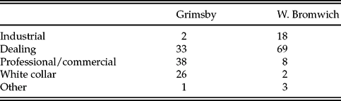
Source: Grimsby Census, 1851; R. Trainor, Black Country Elites: The Exercise of Authority in an Industrial Area, 1830–1990 (Oxford, 1993), 83.
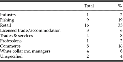
Consideration of leadership shifts attention toward the corporation. Trainor notes that participation in civic administration tended to be one of the few outward manifestations of elite activity available in early nineteenth-century towns.Footnote 27 In Grimsby this remained the case for much of the century. The local Board of Health for example, established in 1852, was the corporation in another guise,Footnote 28 whilst the local Board of Guardians was based in Caistor, nine miles distant, and was dominated by the landed classes.Footnote 29 At this point the corporation itself remained essentially a medium for the exercise of landed patronage and this established pattern of social and political relations was slow to erode. The town clerk was George Babb, a lawyer and a staunch Yarborough man, whilst his successor William Grange, another lawyer, was also active in the service of the landed classes.Footnote 30 By 1900 the composition of the town's considerably expanded municipal elite reflected the more general changes in the town's social structure both of which were now characteristic of a sizable industrial centre rather than a small town (see Tables 3 and 4).
Grimsby Corporation by detailed function group, 1900
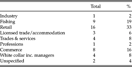
Source: Cook's Grimsby, 1900.
Grimsby middle class by detailed functional group, 1891

Source: Grimsby Census, 1891.
The phenomenal expansion of the fishing trade after 1860 (see Table 5) was the major catalyst for change, generating the wealth necessary for the borough to begin to erode the ties of external patronage. By the end of the nineteenth century, more fortunes were being made in ‘the home of the steam trawler and the fishing millionaire’ than anywhere else in Lincolnshire.Footnote 31 However, parallels with other industrial centres are only partial. In 1850 the fishing trade was non-existent and its establishment was dependent upon railway company initiatives. In the days of sail, capital outlay was modest and the industry was able to expand rapidly on the basis of inward migration (as the railway companies enticed entire fleets to relocate to the town) and relatively small-scale investment.Footnote 32 Successful skippers frequently progressed to become vessel owners and occasionally fleet owners. In contrast, Malcolm Gray's study of Aberdeen points to a later starting point, 1882, and an industry based from the beginning on steam power.Footnote 33 Although some Grimsby operators had experimented with steam in the early 1880s it was not until the 1890s that its application became widespread, massively expanding the industry's productivity. The tonnage of fish landed in Grimsby increased by almost 90 per cent between 1890 and 1900 and by a further 45 per cent between 1900 and 1912 (see Table 5). The switch to steam power also had a profound effect on the structure of the industry, the capital investment required tending toward a substantial concentration of ownership, a trait reflected in the case of Aberdeen.Footnote 34 The ‘fishing millionaire’ emerged in symbiosis with steam power, attracting investment from a diversity of industry outsiders in addition to established fish traders. The coal trader Edward Bannister, for example, became a director of one of the first steam trawling companies whilst George Doughty invested part of his fortune from the building trade to become one of Grimsby's leading fleet owners by 1914.Footnote 35
Fish landed in Grimsby (tons)

Source: N.R. Wright, Lincolnshire Towns and Industry 1700–1914 (Lincoln, 1982), 192.
The magnates of the fishing industry never achieved the level of political dominance exercised by the Lancashire industrialists of Garrard's study.Footnote 36 In 1900 only 9 out of 48 members of the corporation were engaged in the fishing business and of those only 2, H. Mudd and H. Smethurst, were drawn from the industry's wealthiest elite. In contrast, whilst George Sleight (a fish merchant who expanded into trawler ownership) was able to install his family in the mock baronial splendour of Weelsby Hall,Footnote 37 he was conspicuously absent from civic government. A majority of Grimbarians who had a claim to middle-class identity or status in the late nineteenth century kept shop of some form (see Table 4) and their representatives, including publicans, accounted for 19 out of 48 seats on the council, 39 per cent of the overall total. None of these were men of great wealth. Whilst some enjoyed the relative comfort of the suburban villa, a majority resided at their place of business.Footnote 38 Such a substantial petit bourgeois component within local government may have contributed to a somewhat restricted political and commercial vision that was based the rationale and worldview of the small business and the self-employed. In south Staffordshire, high-status middle classes predominated and ‘lower-middle-class dominance . . . had been avoided’.Footnote 39 The situation in Grimsby was rather different, which may go some way to explaining the particular relationship between the middle classes and external forces that existed at the end of the century.
In the early decades of the nineteenth century, patrician rivalry remained the most visible dynamic of political relations. Despite their ability to control the corporation, the Yarboroughs had never enjoyed total control of the freemen. Electoral reform, which the Yarboroughs had long supported,Footnote 40 largely resolved the Yarborough/Tennyson conflict by ending the freemen's electoral monopoly. The result was a period of Yarborough hegemony that remained largely unchallenged for almost three decades. In the decades immediately following the Reform Act an emerging middle class became a major electoral body in the borough, rising from 18 per cent of the electorate in 1835 to 47 per cent in 1865.Footnote 41 A clear majority of these consistently affiliated with the nominees of Brocklesby Hall.Footnote 42 Similarly and despite their historical antagonism a majority of freemen who, in terms of occupation and status, were middle class (half of the total in 1852) also tended to support Yarborough nominees.Footnote 43 Consequently, the relationship between landed elite and the borough remained one of subordinate patronage despite a clearly identifiable and substantial middle-class presence. One explanation for this may simply relate to the leverage inherent in the Yarborough's property in the town. In addition, however, there is little doubt that in their politics (electoral reform) and commercial activity (dock and railway development), the early generations at Brocklesby Hall displayed patterns of behaviour that were empathetic with an emergent middle class.Footnote 44
In the latter half of the 1840s railway construction and new dock developments transformed the borough's economic prospects and initiated a period of sustained and rapid demographic growth. Like the Haven Company, this second phase of capital investment was again patrician led, though the initiative now emanated from Brocklesby Hall. Prospective railway companies began to be canvassed in 1844Footnote 45 and once a suitable project had been identified the family's political dominance in the north of the county assured its unopposed progress, culminating in the arrival of the Manchester Sheffield and Lincolnshire Railway (MSLR) in the borough in March 1848.Footnote 46 The role of the Yarboroughs in general and of the 2nd earl in particular in this period of the town's development is complex and has attracted comment from a number of sources. Cannadine's observations in this context specifically associate Brocklesby Hall with a widely identified aristocratic tendency to promote branch line, as opposed to trunk route, construction on a basis of ‘noblesse oblige’. Enhancement of estate value is regarded as the primary motive.Footnote 47 Similarly, David Hodgkins regards Yarborough involvement in railway promotion as concerned principally with the development of their estates.Footnote 48 However, whilst there is little doubt that material interest was consistently at the core of the Yarborough agenda, the projection of that interest was linked to the development of the region as a whole, rather than being narrowly focused on the Brocklesby estate. This can be illustrated first, by the fact that the Yarboroughs' involvement in railway promotion was not confined to north Lincolnshire where the family's estate was concentrated;Footnote 49 secondly, the MSLR was unequivocally not a branch line, being intended, from the outset, to create a major trunk route linking Grimsby with the potentially lucrative hinterlands of South Yorkshire, Lancashire and the Midlands. Coal was initially regarded as the port's major potential source of traffic.Footnote 50
The Yarboroughs' changing relationship with the Haven Company was indicative of this wider regional perspective within which the development of Grimsby as a major port was a substantial consideration.Footnote 51 In September 1844 the 2nd earl (then Lord Worsley) addressed a meeting of the Haven Company, of which he had become chairman in 1840, stating that ‘he was in communication with the Railway Committee in London on the subject of a line to Grimsby’ and that ‘it was the intention both of the earl of Yarborough and himself to support a railway to Grimsby’ and to ‘render every facility toward the accomplishment of such a project’.Footnote 52 By October 1845, the Haven Company had been formally absorbed by the railway company being actively promoted by Brocklesby Hall. The MSLR, chaired by the 2nd earl, opened a substantial new dock complex in 1852 and by the end of the decade, over £1,000,000 had been spent on the Royal Dock alone.Footnote 53 Jackson's summary of the Yarborough role here is unequivocal: they ‘made the modern town’,Footnote 54 an assessment which parallels the 7th duke of Devonshire's connections with Barrow in Furness and the Furness Railway which resulted in the ‘almost single-handed creation of a new industrial complex’.Footnote 55
Railway hegemony
A progressive deterioration of the Yarborough's political position in the borough occurred concurrently with Grimsby's improving economic situation, a change reflected in contemporary political rhetoric. In 1852, electoral discourse remained rooted in local mythology, the opposition urging the electors ‘to . . . fearlessly and manfully assert their independence’ and to ‘shake off the iron fetters of Brocklesby’.Footnote 56 By the end of the decade the electorate's agenda had shifted and although the unopposed return to Westminster of Yarborough's son in 1857 and 1859 may have suggested business as usual, it actually obscured substantial change.Footnote 57 The major impetus behind Worsley's nomination came from the erstwhile Yarborough retinue within the boroughFootnote 58 rather than Brocklesby Hall and despite the ease of his victories, the new member was viewed with considerable scepticism by an electorate whose agenda was becoming increasingly commercial.Footnote 59 However, the rhetoric of criticism was always careful to delineate between the Brocklesby interest as a whole and the 2nd earl.Footnote 60 Reporting his death in January 1862, the Grimsby Free Press graphically, if grudgingly, acknowledged the 2nd earl's critical role in the development of the town.Footnote 61 In marked contrast, the 3rd earl displayed little interest in industrial or agricultural advancement being conspicuously absent from most matters political and commercial.Footnote 62
Of course, the opening of the MSLR's new dock on 27 May 1852Footnote 63 did not of itself revive the borough's fortunes. Despite a sizable middle-class presence amongst its growing population, the railway company's investment had not generated a replacement for the once substantial mercantile elite which had abandoned the town by the sixteenth century.Footnote 64 Within the municipal elite, a boat builder and a timber merchant were the sole representatives of industry and commerce.Footnote 65 Consequently the railway company itself assumed a hegemonic role from the outset, promoting international traffic even prior to the new dock opening to traffic. By the early 1860s the company operated an extensive continental fleet that carried much of the trade passing through the new dock,Footnote 66 highlighting the extent to which the town was dependent upon the commercial leadership of the railway company which was particularly important for the foundation of the fish trade upon which the town's future prosperity was largely based. In 1851 the trade was negligible and it was the initiative of the railway companies that provided the basis for its extraordinary growth in the latter part of the century. Paradoxically it was the Great Northern Railway (GNR), very much a subordinate partner in Grimsby, that took the lead, enticing entire fleets to relocate to the town. The GNR's direct route to London via Louth and Boston was crucial, enabling the Grimsby trade to exploit lucrative London markets.Footnote 67 The MSLR opened the first of three dedicated fish docks in 1857 though markets in its own hinterland of South Yorkshire and Lancashire did not become significant until the 1870s.Footnote 68
Reflecting Olney's view of the railways emerging as a distinct, arguably dominant, political force,Footnote 69 Hodgkins sees a declining Yarborough influence being superseded by that of the MSLR in an unproblematic fashion.Footnote 70 In doing so, he almost certainly underestimates both the degree of political independence emanating from within the borough and the extent to which a Liberal landed influence continued well into the twentieth century. The Heneage family of Hainton Hall had long been closely associated with the Yarboroughs, united both by marital connections and political affiliation. Between 1835 and 1852, Grimsby was represented in parliament by a Heneage under Yarborough patronage. After 1862, the Heneages gradually assumed the role of their former patrons, becoming particularly prominent after 1880. Despite the evident level of political hegemony exercised by the railway after 1860 simplistic divisions of interest between landowners and railway company are unhelpful. The major landowners and members of the borough elite retained close links with the railway board throughout the second half of the century, in some cases establishing family connections.
The candidacy of MSLR chairman John Chapman in the 1862 election, as a Tory in opposition to the Yarborough nominee, is dealt with by Hodgkins as simply a ‘new dimension’ in the development of the ‘new railway interest’.Footnote 71 However, Chapman's candidacy must also be viewed in terms of facilitating an effective challenge to Yarborough patronage. It is perhaps ironic to find a Tory campaign seeking to exploit antipathy to landed influence, particularly one led by so conservative a figure as Chapman's agent; William Daubney, a lawyer, was one of the borough's wealthiest citizens and a long-standing opponent of the Yarborough influence in the borough. Chapman's campaign was clearly directed at the business interests of the middle classes and its tone and content represent a clear break with the borough's past:
The borough needs advancement, its facilities making the most of and . . . it must have a representative who will keep his eyes about for opportunities . . . and which he will know how to seize – in fact, a man of the times . . . Mr Chapman owns no political creed but asks the suffrage of the electors as a businessman and not as a politician . . . He has a considerable capital invested here and it must naturally be with him a desire to see that invested capital produce a profit and this can only be by increased prosperity to the port.Footnote 72
In contrast, the Liberal candidate G.F. Heneage was a stalwart of county politics and a Yarborough retainer allegedly seeking a safe seat in which to conclude his parliamentary career.Footnote 73
Although the 1862 election established a pattern in which a number of directors and major shareholders of the MSLR served Grimsby in parliament,Footnote 74 it is not indicative of a unitary ‘railway interest’. The Tory victory of 1862 triggered a series of attempts to unseat Chapman by Liberal elements within the MSLR board in alliance with the Liberal elite in Grimsby.Footnote 75 Prominent among the latter was John Wintringham, a young but already very wealthy lawyer.Footnote 76 Wintringham's political connections were already well established: his business partner William Grange, served as town clerk from 1861, whilst his father (John Snr, a successful timber merchant) was Yarborough's agent,Footnote 77 a corporation member of long standing and mayor on five occasions.Footnote 78 In 1864 Wintringham married the daughter of John Fildes, an influential Manchester stockbroker and a major shareholder in the MSLR securing his role as pivotal intermediary, between landed, borough and railway interests.Footnote 79 As the Yarborough influence declined, connections with Hainton Hall became more significant, Wintringham acting as Edward Heneage's agent in the borough from 1876Footnote 80 until his death in 1898.
Developments in Manchester centred on Edward Watkins, the former general manger of the MSLR. In the latter part of the century Watkins was one of the railway industry's most influential figures, assuming the chairmanship of the South Eastern and Metropolitan Railways in addition to that of the MSLR whilst being closely involved in many other undertakings including an abortive channel tunnel scheme.Footnote 81 In 1861 Watkins had resigned over what he considered to be Chapman's misdirection of the companyFootnote 82 and in 1863 joined with a number of powerful Liberal shareholders to effect Chapman's removal.Footnote 83 All were in regular contact with Wintringham in order to generate a base of support in the borough and initially regarded the presence of the new earl of Yarborough on the board as essential to Liberal interests, Wintringham being the key intermediary.Footnote 84 However, even the respected 2nd earl had struggled to counter the domination of Sheffield and Manchester interests on the MSLR boardFootnote 85 and with the 3rd earl resigning his seat after little more than a year,Footnote 86 Brocklesby Hall was becoming increasingly irrelevant to the interests of Grimsby's middle classes. In 1865 Fildes was returned as Grimsby's MP despite having fallen out with Watkins and other key Manchester Liberals.Footnote 87 The importance of this outcome is that it was the result of collaboration by the party elites within the borough and the MSLR board with very little reference to Brocklesby Hall.
The Yarborough reaction was bizarre even by Grimbarian standards; Wintringham's father was dismissed as the Yarboroughs' political agent, a position held under successive Brocklesby tenures and replaced by William Daubney, the Tory agent. On 11 July the Liberal Grimsby Herald reproduced an analysis from the regional press that summarized the situation:
The Earl inherited the family influence . . . but . . . discovered that the ‘influence’ had passed . . . from himself, the inheritor, to Mr John Wintringham, the agent . . . Mr Daubney, the Conservative agent, now stands in the agency relation to the Liberal lord and the ‘influence’ that was supposed to be intact in the hands of the Yarborough family is confessedly so shaken that it starts to assert itself through a conflict with the power that has grown out of itself.Footnote 88
The Yarboroughs nominees in the 1868 election was George Tomline a Tory county squire who had generally been opposed to the interests of Yarborough and Heneage.Footnote 89 Remarkably, Tomline was successful, indicating that the landed influence still exercised some appeal to an electorate that had been greatly enlarged by the 1867 Reform Act.Footnote 90
Chapman regained the seat in 1874 by which point the alleged extent of railway ‘control’ in the borough was giving cause for concern. In 1872, the corporation's apparently meek acquiescence in the MSLR's acquisition of a substantial tract of corporation land at well below its market value attracted considerable comment. Objectors, including Wintringham Snr, suggested that as ‘several company employees’ were among its twelve councillors,Footnote 91 the corporation was effectively managed by the railway. However, although the corporation was certainly well aware of the borough's dependence on the company for economic leadership, in 1872 only two members of the corporation worked for the MSLR. Of these only James Reed the Port master was a full-time employee, whilst Henri Jose, a ship broker and coal trader, listed management of the MSLR's shipping subsidiary as a secondary employment.Footnote 92 What is evident in the composition of the corporation at this point is economic and structural change. Commercial, industrial, fishing and managerial occupations now accounted for 12 of the 16 members and amongst these is evidence of the town's increasing wealth.Footnote 93 There is no denying the pervasive influence of MSLR chairman Watkins and the election of his son as the Borough's MP in 1877, in which role he served ineffectually for three years,Footnote 94 tended to confirm suggestions of railway control. However, the situation was changing by 1880. Edward Heneage's candidacy was occasioned by a resurgence and reorganization of Liberalism, at both borough and county level, rather than any notion of ‘string pulling’ by Watkins, and the new MP, though a substantial shareholder in the MSLR, was emphatically not a railway nominee.Footnote 95
Socio-political relations in the later nineteenth century
Simon Gunn observes that the significance of politics in the articulation of middle-class identity receded after 1840, being replaced by, amongst other factors, ‘conduct’.Footnote 96 In the case of Grimsby, however, political organization and activity remained one of the most visible and significant aspects of middle-class identity well into the twentieth century. A clear example of this is the Grimsby Liberal Association which played a critical role in the revival of Liberalism in the region. It was established in 1879 quite independently of landed or railway influence and was instrumental in the Liberal victory of 1880.Footnote 97 By the end of the century, middle-class control of the borough was consolidated through a greatly expanded corporation and a plethora of other local bodies which included, after 1890, a Grimsby Board of Guardians.Footnote 98 The corollary to this in terms of Gunn's analysis is the scarcity of other areas of ‘conduct’: whilst not completely absent, these are far less prevalent than might be expected given the extent to which activity such as philanthropy and public service arguably defined the late Victorian middle classes both in terms of self-perception and the legitimacy of their position in society as a whole.Footnote 99 Neither the middle class in general nor its representatives who constituted the municipal elite appear to have been markedly proactive in advancing either the borough's economy or the living conditions of its people, whose numbers had grown from under 9,000 to 63,000 in the 50 years to 1901.Footnote 100 In 1885, Kelly's Directory noted of Grimsby ‘the charities are not very numerous’ reiterating the comment in 1905.Footnote 101
The one substantial example of philanthropic enterprise in the town was the body supporting the Grimsby and District Hospital, the timing and financing of which are revealing. In October 1863 the corporation had impressed the growing self-confidence of the middle classes on the physical landscape of the town with the official opening of a grandiose new town hall. Built to replace a dilapidated eighteenth-century structure at a cost of over £8,000 its opening ceremony occasioned perhaps the most lavish display of civic pomp yet seen in the borough.Footnote 102 Around the same time, accident and injury being an almost incidental fact of life in a rapidly expanding industrial town, a campaign for the foundation of a Grimsby hospital began to appear in the local press. According to such correspondence, the stark contrast between the costly development of the civic landscape and the total absence of hospital provision was both morally indefensible and presented a negative image of the town.Footnote 103
Despite the motivation of a few public-spirited citizens it was not until January 1865 that a committee was constituted, consisting of a cleric, a teacher, three merchants, a ship builder, four managers and three self-employed fishing smack owners, plus ‘all the town's medical men’ with mayor John Wintringham Snr in the chair.Footnote 104 However, although the committee's composition closely mirrored that of the corporation and might therefore be regarded as reflecting the mood of the middle classes as a whole, it struggled to raise both consciousness and money. A further 16 months elapsed before sufficient funds had been secured to establish the most rudimentary hospital adjacent to the Royal Dock. Subsequently, though a building fund for a permanent, purpose-built hospital was initiated almost immediately, it was October 1873 before a statement of intent to construct a new ‘hospital/infirmary’ was issued.Footnote 105 Such reluctance to address the perceived needs of an urban population becomes more poignant in the context of demographic change. Between 1865 and 1873 the population had nearly doubled and was approaching 30,000 (see Figure 1).
The crucial initiative came from outside the borough. In 1875 Edward Heneage, then high steward of the borough, offered a site for construction on the northern edge of his Grimsby estate and was immediately accused of seeking political and financial profit.Footnote 106 Whatever the reality of Heneage's motives, the corporation was galvanized into offering a plot of its own land and with Hainton and Brocklesby Halls visibly assuming the initiative in fund raising, subsequent progress was rapid: the new hospital was duly opened by the countess of Yarborough, accompanied by Edward Heneage, in May 1877. Having built a hospital, however, the wealthier citizens of Grimsby continued to display a marked reluctance to sustain it:
I was glad to see the [Grimsby] Observer impress upon the working men, whose class will mainly benefit by the institutions, the duty of contributing more liberally towards it. The aristocracy has nobly done its part in the matter and it now remains for the wage-earning population to imitate according to their means the example set them.Footnote 107
In addition, it should be noted that at £4,000, the cost of the project was less than half the sum spent by the corporation on its new town hall 14 years earlier.Footnote 108
Heneage's role in the hospital project was perhaps symptomatic of his relations with the borough in general. Heneage served as the borough's MP almost constantly between 1880 and 1896 and was widely recognized for furthering its interests in parliament, not least in its securing county borough status in 1891.Footnote 109 Whether or not Heneage relates to landowners such as Fitzwilliam and Calthorpe identified by Cannadine as ‘intermediaries prepared to convey middle-class opinion to Westminster’ is debatable.Footnote 110 His relationship with the borough was for the most part pragmatic at best which is perhaps reflected in the fact Heneage was, in the view of Dowling, ‘never accorded the honour of being appointed mayor of the town he did so much to create’,Footnote 111 a term which in this context is perhaps rather more than metaphorical. Given the rate of demographic change in the last quarter of the century, issues relating to the urban condition were inevitably a major political issue and one which it might reasonably be anticipated would solicit some conscious and cohesive response.Footnote 112 In the Grimsby press, the issues of public health and housing were frequently projected as the major tests of the elite's perceived fitness to govern,Footnote 113 which implicitly reflected upon the middle classes in general from which it was exclusively drawn.
Potential building land within the old borough being exhausted by 1870, three areas of property on the periphery emerged as the focus of scrutiny, each displaying notably divergent characteristics. Immediately to the east of the borough boundary, the New Clee estate of the Grant-Thorold family quickly became associated with the worst urban deprivation in the Caistor Union,Footnote 114 unregulated by even Grimsby's laxly applied housing by-laws.Footnote 115 To the west of the town a simultaneous and extensive development, known locally as the West Marsh, was equally condemned for its poor standards of execution and ignorance of housing by-laws.Footnote 116 The major difference was that while the Grant-Thorold estate was outside the jurisdiction of the corporation, the West Marsh was its own property. The development of Heneage's extensive lands to the south and south-east was notably different. Some contemporaries such as Dr Keetley, a long-standing public health campaigner, regarded Heneage as an opportunistic speculator,Footnote 117 whilst some more recent populist opinionFootnote 118 regards him as a visionary of urban improvement.Footnote 119 What is beyond dispute is that the development of the Heneage estate was, for the most part, executed to a standard previously not seen in Grimsby, Heneage himself assuming direct control over planning and building standards. In 1881 a public letter was circulated in which he expressed concern for social cohesion and a determination to ‘protect the neighbourhood against those evils from which some other portions of the town too notoriously suffer’. It also stressed satisfaction at how few residents of his estate appeared before the local bench.Footnote 120 Heneage and Wintringham assiduously projected an image of a progressive and benevolent landlord,Footnote 121 reflecting a view that properly directed philanthropy and astute civic leadership were crucial to the creation of social order and stability.Footnote 122 Arguably, such a view was missed by the municipal and economic leaders of Grimsby's middle classes.
Despite such evident shortcomings, the establishment of the Grimsby Board of Guardians (1890)Footnote 123 and the attainment of county borough status (1891)Footnote 124 confirmed middle-class controlled self-government of the largest and richest urban centre in the county. The contradiction was highlighted by Wintringham who used the occasion of his installation as the borough's first honorary freeman to address the conservatism and complacency of Grimsby's leadership. Wintringham observed that its economic base remained narrow and largely dependent upon external initiative, particularly that of Yarborough, Heneage and the railway companies, and commented on the implications for social cohesion associated with the limited nature of elite hegemony emanating from the borough.Footnote 125
Of course, the record of Grimsby's civic elite was not unique; a catalogue of failure and inaction was characteristic of the civic elite of Leeds, for example.Footnote 126 Both were long-established corporate boroughs which may indicate that deeply entrenched civic cultures often struggled to respond to changing circumstances. Established relationships and patterns of behaviour have been also identified as a significant influence on the nature and course of elite action in Dundee in the first half of the nineteenth century.Footnote 127 In Grimsby, civic inertia was conspicuously long-lived and the implications are perhaps all the more poignant given the extent to which politics remained a major manifestation of middle-class identity; the dearth of philanthropic endeavour remained well into the twentieth century, leaving the civic elite and public office as the principal means by which middle-class culture related to and was legitimized within the rest of borough society. In 1887 Dr Keetley was still berating the council's failure to address the urban condition just as he had done 30 years earlier.Footnote 128 Gunn's observationFootnote 129 regarding the fractious nature of middle-class dominated urban politics is almost certainly applicable in the case of Grimsby. In 1875 a Hull journalist reported that ‘in respect of internecine quarrelling . . . few places could equal it’.Footnote 130 Such constraints may, in part, explain why external initiative remained important. Heneage, for example,Footnote 131 was able to direct the development of his estate without paying heed to the remonstrations of ratepayers' groups which could represent a serious impediment to council led urban improvement.Footnote 132
Although weakness of philanthropic impulse and a reluctance to fund urban improvement characterized Grimsby's middle classes in general, such traits were far less evident in their endowment of churches and chapels. In the early days of the fishing industry devout Methodism and abstinence had characterized its leadershipFootnote 133 and by the end of the century the upper echelons of Grimsby society had produced a level of ecclesiastical provision commensurate with that of the cathedral city of Lincoln.Footnote 134 In the eyes of the masses, however, religious devotion was a poor substitute for social action and as the fishing elite prospered, overt displays of piety came to be regarded with increasing cynicism by a population that continued to suffer the degradation of poverty and urban squalor. In 1879 a group led by one James Meadows, a fish merchant of some substance, raised £480 merely to provide stained glass for the new church of St John the Evangelist, established in the midst of the slums of New Clee.Footnote 135 Writing to the Grimsby Observer a shipwright listed the endowment of chapels as an aspect of an ostentatious lifestyle, alongside large houses, horses, carriages, servants and champagne, which ‘he and his mates’ considered to be symptomatic of the town's fishing elite.Footnote 136
Conclusion
On initial examination, Grimsby at the close of the nineteenth century epitomized middle-class success. Their representatives dominated the town's political institutions and many had amassed considerable wealth. The borough's MP, George Doughty, was a local man and a ‘self-made’ millionaire. In the public sphere, the town hall and other civic buildings together with the ritual and aggregated privileges and practices of incorporation presented a vision of municipal independence. In the private sphere, the residential lifestyle of the wider middle classes, from the splendour of Weelsby Hall to the modest affluence of white-collar suburbs, provided a visible indicator of remarkable economic progress. On closer examination, however, the ‘triumph’ of Grimsby's middle class is subject to qualification. Despite the wealth and size of Grimsby's industrial and commercial bourgeoisie, the impetus for economic development remained external and the borough leadership remained inept in confronting the major problems of nineteenth-century urban life on both a municipal and a philanthropic level. Leadership shortcomings, which Wintringham at least appears to have been well aware of, were illustrated quite starkly in 1901. During that year, the port's trawler owners found themselves embroiled in an increasingly bitter and protracted dispute, arguably of their own making.Footnote 137 The resulting crisis required police reinforcements from Sheffield and Manchester and the posting of units of the Lincolnshire regiment to strategic points in the town.Footnote 138 After weeks of acrimonious stalemate the dispute was settled in a matter of hours by the mediation of Heneage and Yarborough.Footnote 139