


Introduction
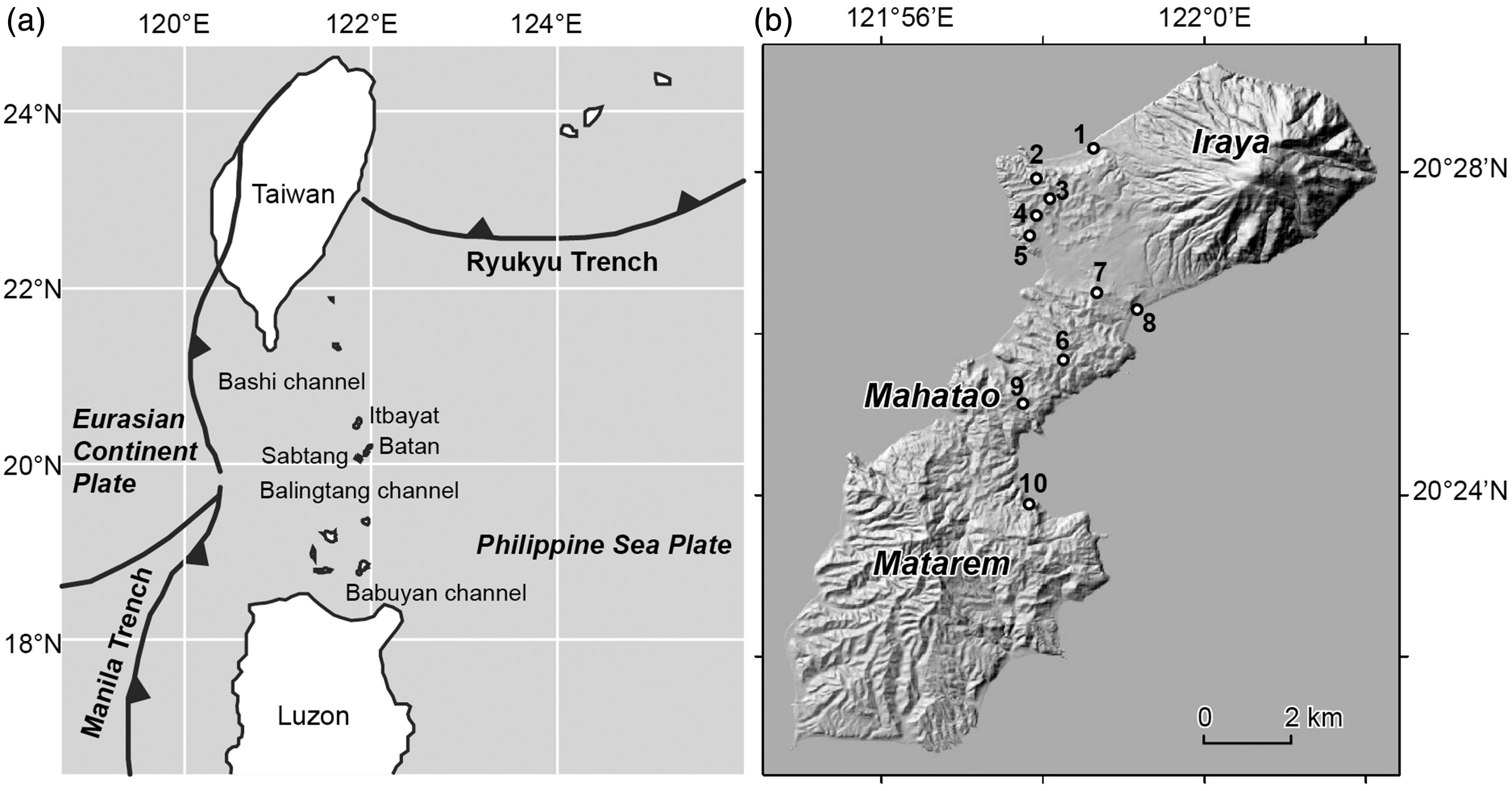
Batan Island is the main island of Batanes Province, bordering the northernmost territory of the Philippines and located in the western part of the Philippine Sea Plate, where the Eurasian Plate subducts along the Manila Trench (Figure 1A). Batan Island is composed of three volcanic units: Late Miocene Mahatao, Pliocene to Early Pleistocene Matarem, and Late Pliocene to Holocene Iraya volcanoes (Figure 1B), with generally andesitic to basaltic composition (Richard et al. Reference Richard, Maury, Bellon, Stephan, Boirat and Calderon1986). Xenoliths are known to be abundant in the recent calc-alkaline pyroclastics erupted from Iraya volcano (Arai et al. Reference Arai, Takada, Michibayashi and Kida2004; Richard et al. Reference Richard, Maury, Bellon, Stephan, Boirat and Calderon1986). Richard et al. (Reference Richard, Maury, Bellon, Stephan, Boirat and Calderon1986) reported three 14C ages for the eruption age for Iraya Volcano: 2310 ± 80 BP (charcoal fragments), 1700 ± 210 BP (wood fragments), and 1480 ± 50 BP (wood fragments).
Index maps. (A) Map showing location of Batan Island between Luzon and Taiwan. (B) Relief map showing location of investigated sites in Batan Island.

Batan Island, an approximately 18-km long dumbbell-shaped landmass, is the most densely populated in Batanes Province. Located at the northern edge of the tropics, it lies about 150 km south of Taiwan and 200 km north of Luzon (Figure 1A). It is separated from Luzon mainland by the Balintang Strait and the Babuyan Islands, and from Taiwan by the Bashi Channel. Batanes was included in the UNESCO World Heritage Tentative List due to its unique natural and cultural heritage in 2004. Archaeologically, the Austronesians are thought to have spread from Taiwan to the Philippines, then to the Indonesian islands and the Pacific islands (Bellwood Reference Bellwood1997). One clear evidence is the discovery of similar red slip pottery that has been excavated from Neolithic sites in Cagayan, northern Luzon, and the east coast of Taiwan (Hung Reference Hung2005; Tanaka Reference Tanaka2021). In the Batanes Islands, pots and jar burial practices have been developed, which could have been indigenous to the island or as a result of an inter-island interaction/trading as observed from the life of native Ilocos people of Luzon mainland. Garong (Reference Garong2013) reconstructed ancient diets from jar coffin burials using the carbon-nitrogen stable isotope analysis of human bone collagen, revealing a diet primarily based on C3 plants with limited marine dependence. Oxygen and carbon isotope analysis of tooth enamel suggested a stable lifestyle with relatively little migration or migration from the islands (Garong Reference Garong2013). In this way, archaeological and anthropological research has revealed the cultural style unique to Batanes Island.
Batan is considered the most fertile island in the Batan group of islands, especially due to abundance of volcanic ash soils in its central part between Iraya and Matarem volcanoes. The peak of the volcano is often covered by clouds, that yield precipitation as one of its water resources. Most of the archaeological sites in this island are found both on the coastal and inland areas (Bellwood and Dizon Reference Bellwood and Dizon2005, Reference Bellwood and Dizon2013). In order to assess the effect/impact of the eruption of Iraya Volcano on ancient people, we conducted a field survey of eruptive products and archaeological sites on Batan Island which is part of a collaborative research project between the Philippines and Japan. This paper presents the Holocene tephra stratigraphy and AMS (accelerator mass spectrometry) radiocarbon dates in Batan Island, as well as the occurrence of tephra in an archaeological site.
Materials and methods
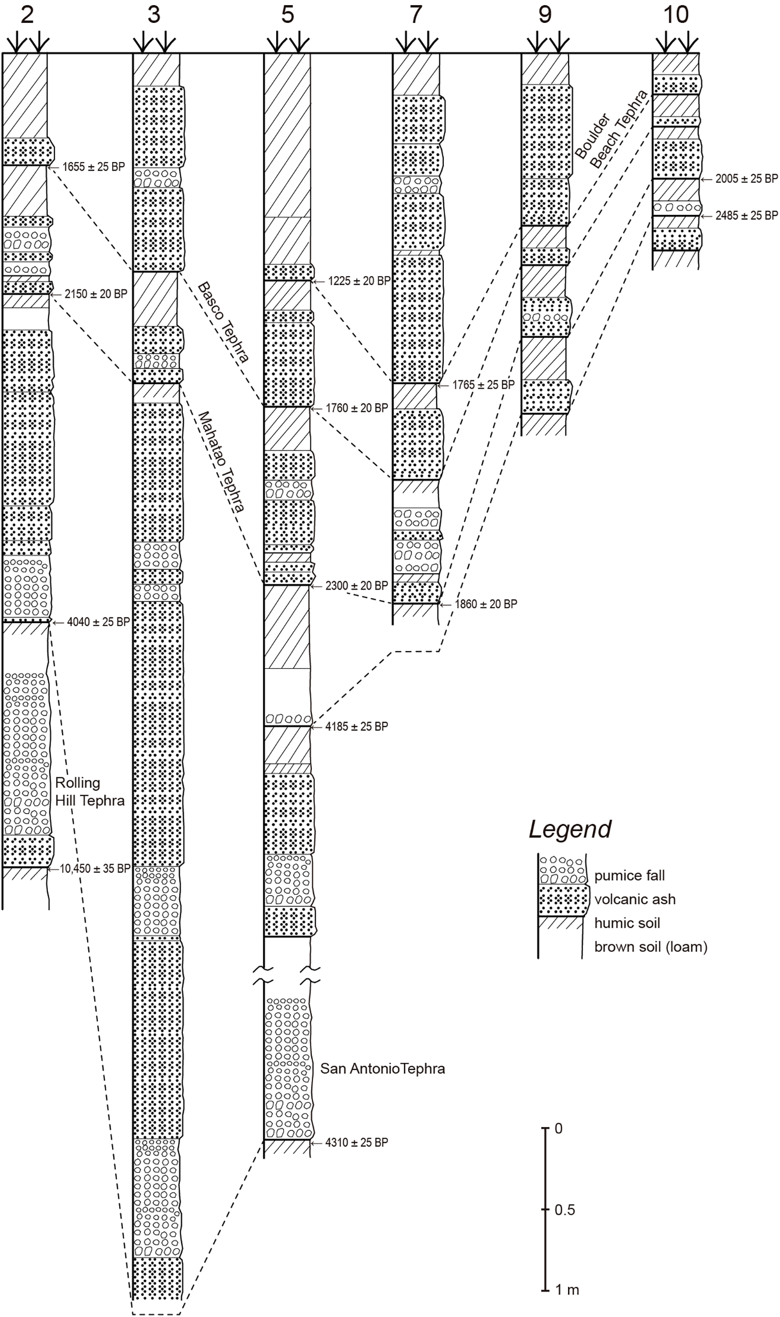
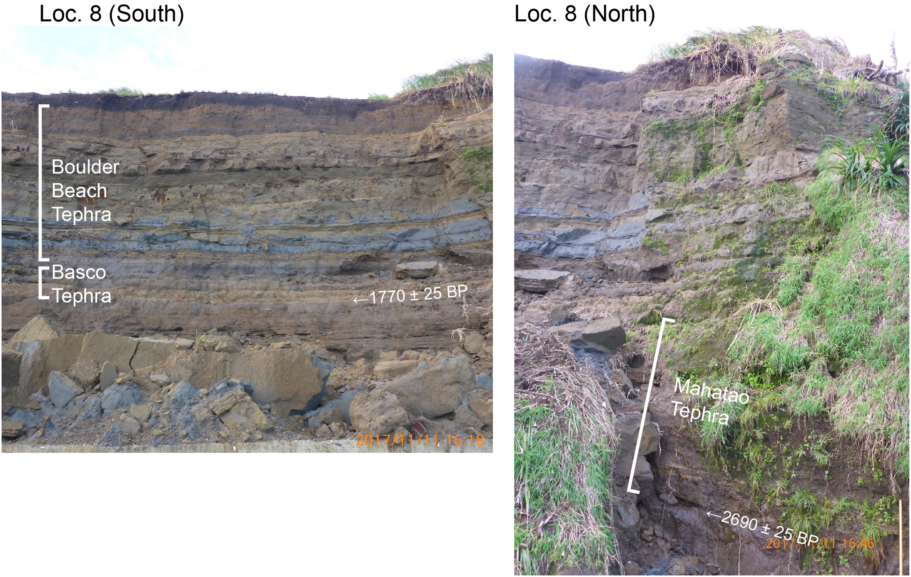
Geological survey and archaeological excavation were conducted on Batan Island. Tephra layers were identified in columnar sections (Figure 2), and samples were collected for petrographic analysis and radiocarbon dating. Figure 3 shows an outcrop photograph of the thick tephra layer exposed on the sea cliff at Loc. 8. Archaeological excavation was specifically conducted at the Reydante Cabizon Property (Reydante site) in Brgy. San Antonio, Basco.
Columnar sections for the Holocene tephra with radiocarbon date (BP). Locality of each site is shown in Figure 1.

Photographs showing an outcrop of the thick tephra layer exposed on the sea cliff at Loc. 8 with radiocarbon date (BP). Locality of this site is shown in Figure 1.

All tephra samples were ultrasonically cleaned and observe the mineral phenocrysts using a polarizing microscope. Dimensions of essential phenocrysts like amphibole were measured to correlate their presence with field observations.
In this study, soil and charcoal samples were systematically collected. Twenty-one (21) samples were treated with acid-alkali-acid (AAA) and their 14C ages were measured by accelerator mass spectrometry (AMS) at Accelerator Analytical Laboratory Inc. (Japan). The acid treatment was performed using 1M HCl, and the alkaline treatment was performed using NaOH solution, with the concentration increasing from 0.001M to 1M. The sample was then washed with ultrapure water and dried. The sample was combusted to generate CO2, which was then purified in a vacuum line and reduced with hydrogen using iron powder as a catalyst to produce graphite. The graphite was pressed into a cathode with an inner diameter of 1 mm, which was then fitted into a wheel. The 14C counts, 13C concentration (13C/12C), and 14C concentration (14C/12C) were measured using a 14C-AMS (manufactured by NEC Corporation). Oxalic acid (HOx II) provided by the National Bureau of Standards (NIST) was used as the standard sample, and background samples were also measured at the same time. The obtained 14C ages (BP) were calibrated to calendar years (cal BP) using the IntCal20 radiocarbon calibration curve (Reimer et al. Reference Reimer, Austin, Bard, Bayliss, Blackwell, Bronk Ramsey, Butzin, Cheng, Edwards, Friedrich, Grootes, Guilderson, Hajdas, Heaton, Hogg, Hughen, Kromer, Manning, Muscheler, Palmer, Pearson, van der Plicht, Reimer, Richards, Scott, Southon, Turney, Wacker, Adolphi, Büntgen, Capano, Fahrni, Fogtmann-Schulz, Friedrich, Köhler, Kudsk, Miyake, Olsen, Reinig, Sakamoto, Sookdeo and Talamo2020) by means of computer software Calib 8.20 (Stuiver and Reimer Reference Stuiver and Reimer1993).
Results and discussion
Holocene tephra stratigraphy
Iraya Volcano tephra units is distinguished, from bottom to top, as Rolling Hills, San Antonio, Mahatao, Basco, and Boulder Beach (Figure 2). The Holocene tephras are primarily hornblende dacite, featuring pumice of brown, white or milky white color. It includes fresh gray and weathered brown fragments, along with free crystals of plagioclase, amphibole and pyroxene.
Rolling Hills tephra is the earliest Holocene tephra erupted from Iraya Volcano. It is well-expressed along uphill road in Loc. 2 and generally consists of a massive pumice lapilli fallout layer (∼80 cm thick) overlying a relatively thin volcanic ash layer (∼10 cm). The volcanic ash layer is slightly indurated consisting of pale blue to gray-colored very fine ash with intercalation of coarse-grained ash. The pumice fallout layer is well-sorted and generally consists of subangular to subrounded clasts. The maximum size of pumice clast is 3.8 cm in diameter (MP: average of 3 grains). A vesiculated pumice contains large amphibole phenocrysts (predominant length: 0.3–0.5 mm), some up to 1 mm. The amount of phenocrysts is more dominant than in the San Antonio tephra. The surface is slightly weathered and brownish. The basal ash contains pumice but overall contains a large amount of dense, gray, accessory lava and weathered lithic fragments. It may have been incorporated by destroying the original volcanic edifice at the beginning of the Rolling Hills eruption.
San Antonio tephra overlies the Rolling Hills tephra in Loc. 2, with soil layer in between. The sequence is clearly observed in Loc. 3. From the bottom, it consisted of very fine volcanic ash (∼30 cm thick) followed by layers of massive pumice lapilli fallout (∼40 to 80 cm thick, MP=6.5 cm, ML=5.6 cm) with intercalations of slightly indurated very fine ash layers (∼80–120 cm thick). Pumice lapilli fallout layers have presence of minor coarse ash and other lapilli-sized clasts that are dark-colored and oxidized. The very fine ash layers have varying colors of gray, purple, and buff and with intercalations of coarse ash to lapilli-sized clasts. The size of the amphibole in a vesiculated dacitic pumice is small (predominant length: 0.1–0.2 mm) and the amount of phenocrysts is few. The surface of pumice is weathered and generally shows a light brown color. Basal ash contains vesiculated white pumice similar to the upper part but also contains non-vesiculated gray dacitic lava fragments and weathered lithic fragments. As with the Rolling Hills eruption, it is possible that these fragments were originated from the early destruction of the original volcanic edifice. At Loc. 5, the size of amphibole in vesiculated pumice is large (predominant length: 0.3-0.5 mm), with some measuring 1 mm and has a large amount of phenocrysts. The pumice grain is very similar to the Rolling Hill tephra at Loc. 2.
Mahatao tephra clearly overlies San Antonio tephra as separated by a key soil layer in Loc. 5. This key soil layer has characteristic presence of scattered and weathered pumice lapilli clasts (MP=1.5 cm) that are orange colored. The size of the amphibole in the orange-colored pumice is large (predominant length: 0.2-0.4 mm), with some measuring 1 mm in diameter. The amount of phenocrysts is more dominant than San Antonio tephra. The key soil marker is overlain by another soil-like layer (∼65 cm thick) that is massive and dark-colored, followed by Mahatao tephra sequence. The Mahatao tephra consists of a set of very fine volcanic ash layers (∼6–12 cm thick) from the bottom, thin soil-like layer (∼5 cm thick), a layer of volcanic ash matrix (∼32 cm thick) with some pumice and oxidized clasts, and a well-sorted pumice lapilli fallout layer (∼20 cm thick, MP=2.5 cm) with occasional hydrothermally altered lithics. Dominant portions of this tephra unit were observed in Locs. 9 and 10, both distal outcrops within the Municipality of Mahatao. Compared to the San Antonio tephra observed in Locs. 2 and 3, the amphibole size is slightly larger (predominant size: 0.2 to 0.5 mm) and contains more phenocrysts at Locs. 5 and 7. It also contains dense lava fragments and weathered lithic rock fragments.
Basco tephra consists of gray to buff-colored consolidated very fine ash layers (∼50 cm thick) intercalated by thin coarse ash layers (∼2 to 3 cm thick), which lies above the soil layer covering Mahatao tephra. The sequence can be clearly observed in Locs. 5 and 7. The consolidated volcanic ash contains a large amount of accretionary lapilli (Lorenz Reference Lorenz1974; Schumacher and Schmincke Reference Schumacher and Schmincke1991) that indicate a phreatomagmatic eruption. The size of the amphibole in pumice is small (predominant length: 0.1–0.3 mm), but the amount of phenocrysts is more dominant than Boulder Beach tephra.
Boulder Beach tephra is the uppermost Holocene tephra of Iraya Volcano, and is clearly observed along coastal area in Loc. 8. It generally consists of a brown-colored very fine ash layer (∼9 cm thick) over a relatively thick soil layer (∼12 cm thick). The size of amphibole in a vesiculated pumice is small (predominant length: 0.1–0.2 mm) and few phenocrysts were observed. At Loc.7, most of the particles larger than 2 mm are vesiculated pumice, with a small amount of lithic fragments. At Loc. 5, an overlying surface soil layer has an unusual thickness (∼1–1.3 m thick) and is slightly black in color containing some pottery fragments as observed, which may suggest a possibility of redeposition.
Eruption ages inferred from radiocarbon dates
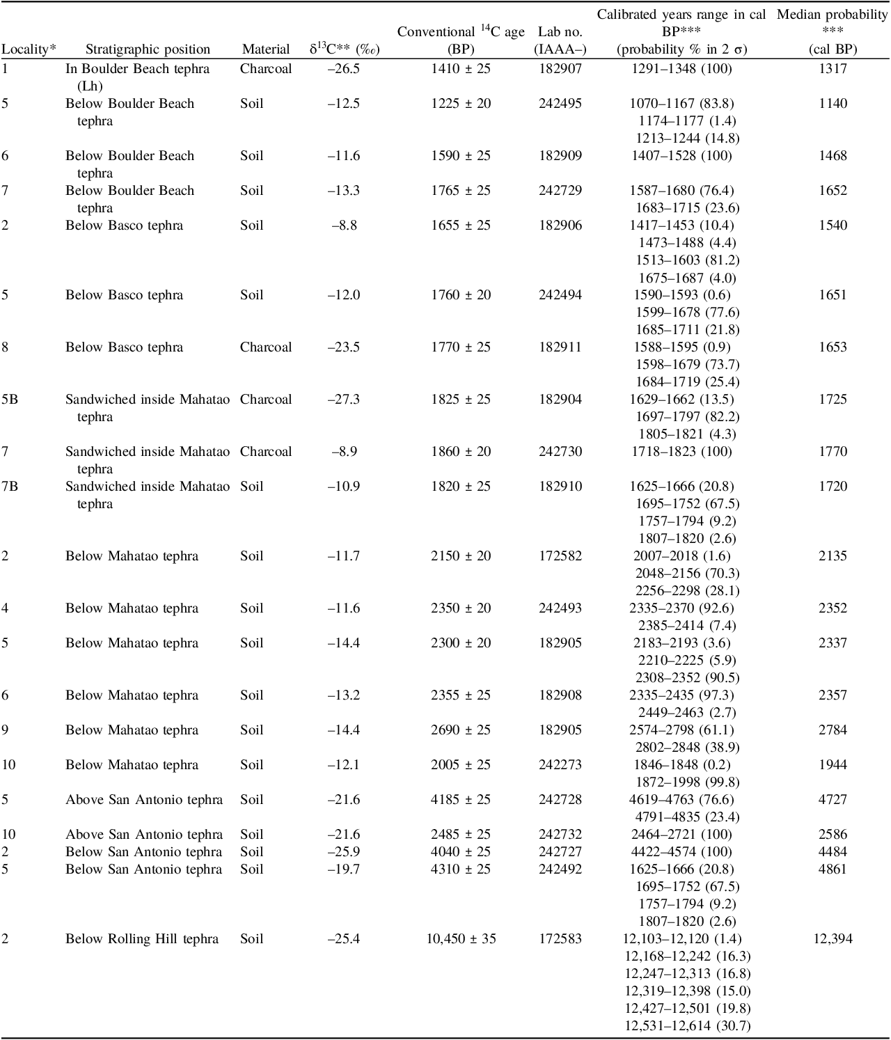
The radiocarbon ages obtained align well with the tephra stratigraphy (Table 1; Figures 2–4) and are deemed reasonably reliable. These data allow us to constrain the timing of Holocene eruptions from Iraya Volcano.
AMS radiocarbon ages of the soil and charcoal samples obtained from around Iraya Volcano

Table 1 Long description
A table comparing radiocarbon ages of soil and charcoal samples around Iraya Volcano. The table has 10 columns and 16 rows. Column headers are: Locality, Stratigraphic position, Material, delta 13C (permil), Conventional 14C age (BP), Lab no. (IAAA–), Calibrated years range in cal BP (probability % in 2 sigma), and Median probability (cal BP). Row 1: Locality 1, In Boulder Beach tephra (Lh), Charcoal, -26.5, 1410 ± 25, 182907, 1291–1348 (100), 1317. Row 2: Locality 5, Below Boulder Beach tephra, Soil, -12.5, 1225 ± 20, 242495, 1070–1167 (83.8), 1140. Row 3: Locality 6, Below Boulder Beach tephra, Soil, -11.6, 1590 ± 25, 182909, 1407–1528 (100), 1468. Row 4: Locality 7, Below Boulder Beach tephra, Soil, -13.3, 1765 ± 25, 242729, 1587–1680 (76.4), 1652. Row 5: Locality 2, Below Basco tephra, Soil, -8.8, 1655 ± 25, 182906, 1417–1453 (10.4), 1540. Row 6: Locality 5, Below Basco tephra, Soil, -12.0, 1760 ± 20, 242494, 1590–1593 (0.6), 1651. Row 7: Locality 8, Below Basco tephra, Charcoal, -23.5, 1770 ± 25, 182911, 1588–1595 (0.9), 1653. Row 8: Locality 5B, Sandwiched inside Mahatao tephra, Charcoal, -27.3, 1825 ± 25, 182904, 1629–1662 (13.5), 1725. Row 9: Locality 7, Sandwiched inside Mahatao tephra, Charcoal, -8.9, 1860 ± 20, 242730, 1718–1823 (100), 1770. Row 10: Locality 7B, Sandwiched inside Mahatao tephra, Soil, -10.9, 1820 ± 25, 182910, 1625–1666 (20.8), 1720. Row 11: Locality 2, Below Mahatao tephra, Soil, -11.7, 2150 ± 20, 172582, 2007–2018 (1.6), 2135. Row 12: Locality 4, Below Mahatao tephra, Soil, -11.6, 2350 ± 20, 242493, 2335–2370 (92.6), 2352. Row 13: Locality 5, Below Mahatao tephra, Soil, -14.4, 2300 ± 20, 182905, 2183–2193 (3.6), 2337. Row 14: Locality 6, Below Mahatao tephra, Soil, -13.2, 2355 ± 25, 182908, 2335–2435 (97.3), 2357. Row 15: Locality 9, Below Mahatao tephra, Soil, -14.4, 2690 ± 25, 182905, 2574–2798 (61.1), 2784. Row 16: Locality 10, Below Mahatao tephra, Soil, -12.1, 2005 ± 25, 242273, 1846–1848 (0.2), 1944.
* See Figure 1B
** measured by AMS
*** using the computer software Calib 8.20 with the IntCal20 data set
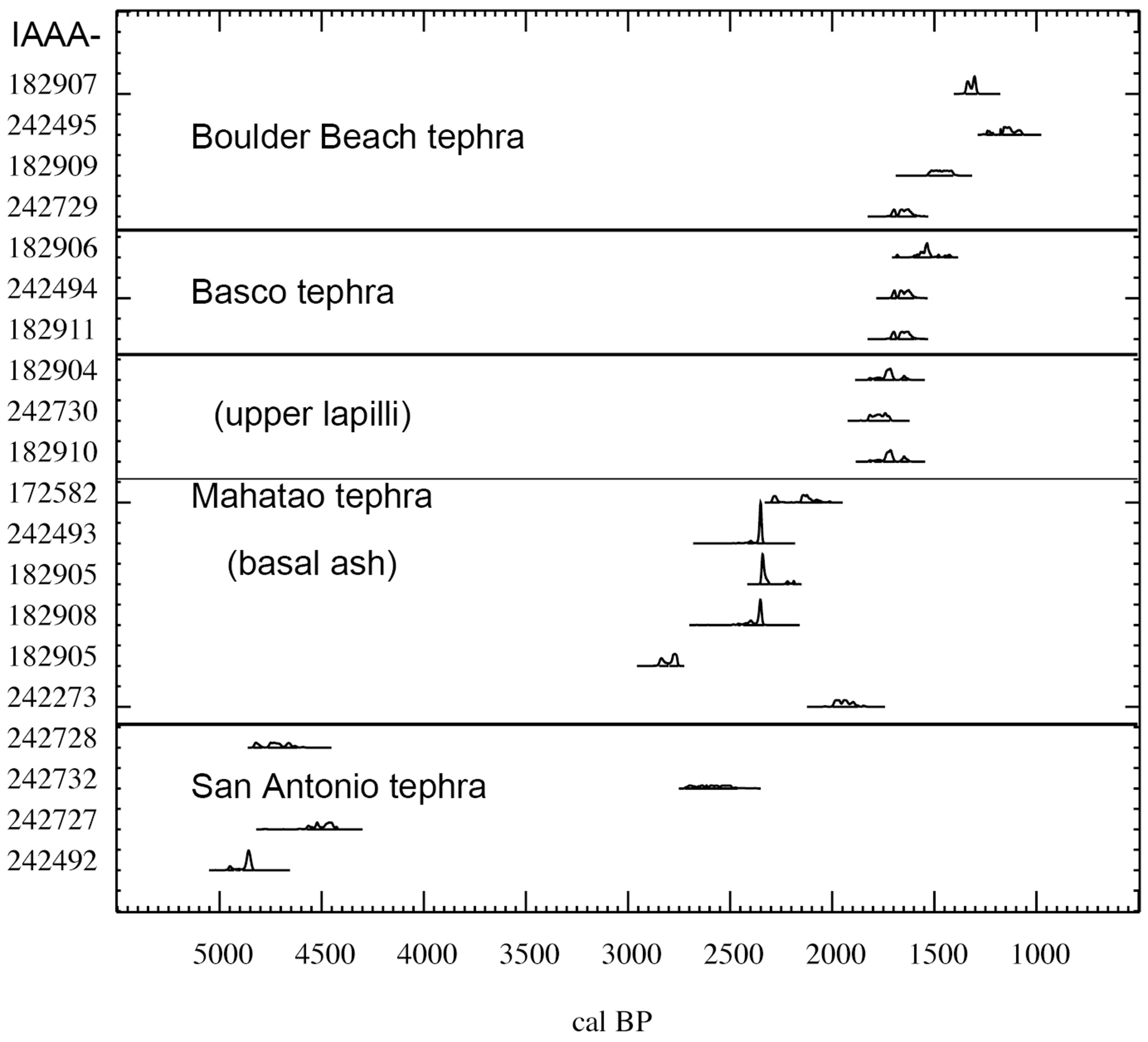
Probability distributions for calibrated ages of multiple samples related with Holocene tephra of Iraya Volcano using the computer software Calib 8.20 with exception on Rolling Hills tephra.

The ages of each tephra are determined based on 14C dating of the paleosols directly beneath the tephra. The Rolling Hills tephra is dated to about 12.4 cal ka BP, the San Antonio tephra to about 4.5–4.9 cal ka BP. Dates obtained from directly beneath the Mahatao tephra are approximately 2.1–2.5 cal ka BP, but a thin soil-like layer intercalated within the Mahatao tephra is dated to about 1.7 cal ka BP, suggesting that this tephra may have been the result of a separate eruptive phases (basal ash and upper lapilli). The ages of the two phases are approximately 2.3 cal ka BP for the basal ash and 1.7 cal ka BP for the upper lapilli. The Basco tephra is dated to about 1.6 cal ka BP, and the overlying Boulder Beach tephra is dated to about 1.2 to 1.6 cal ka BP.
Most of the deposits currently exposed on the western coast are lahar deposits, the last eruption is associated with block-and-ash flow deposits (Richard et al. Reference Richard, Maury, Bellon, Stephan, Boirat and Calderon1986). This paper also obtained an almost identical age of 1410 ± 25 BP (IAAA-182907) for the deposits of the last eruption. The eruption not only generated block-and-ash flow deposits at the foot of Iraya Volcano but also produced related ash fall (Boulder Beach tephra) over the island. The remaining ages of 2310 ± 80 BP and 1700 ± 210 BP correspond to the ages of the Mahatao tephra in this paper (Table 1). The calibrated calendar dates for the Mahatao tephra show divergence (Figure 4), suggesting the eruption may have occurred in two distinct phases.
Chronology of Reydante Cabizon Property Site
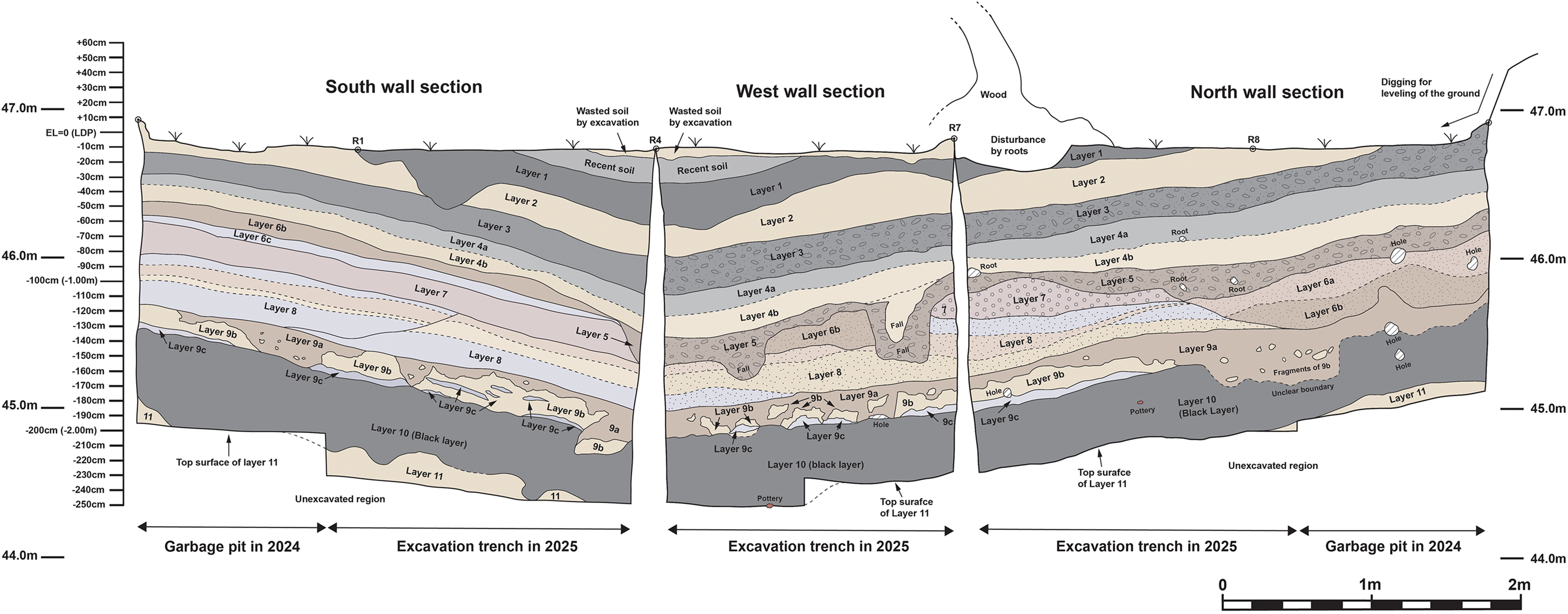
At the Reydante Cabizon Property Site in San Antonio Village, Diptan, Basco (Loc. 4 in Figure 1B), a double animal-headed ear pendant was recovered (Tanaka et al. Reference Tanaka, Garong, Yamagiwa, Dizon and Okuno2024). It was discovered by Mr. Reydante Cabizon when he excavated a hole in his property. A 40-50 cm thick black cultural soil layer (Layer 10), containing earthenware pottery sherds and other artifacts, was identified beneath approximately 1.5 m thick of the fine ash and pumice tephra layers (Layers 3–9, corresponding to the Mahatao tephra) on the excavation unit wall (Figure 5). Further tephra sediments (Layers 8, San Antonio tephra) were confirmed under the cultural layer (Layer 10). Thus, this cultural layer, formed between the San Antonio (approximately 4.5–4.9 cal ka BP) and Mahatao tephra (approximately 2.1–2.5 cal ka BP) units, represents a stratigraphic marker of human activity potentially influenced by volcanic events on Batan Island.
Sketch of excavation wall profile at the Reydante Cabizon Property Site (Loc. 4). Illustration by Kaishi Yamagiwa.

The double animal-headed ear pendant was also excavated in the upper most layer of the jar burial assemblage of Duyong cave in Palawan Island in the Philippines (Fox Reference Fox1970). Such double animal-headed ear pendants were discovered in many archeological sites around the South China Sea (Hung and Bellwood Reference Hung, Bellwood, Berenice, Elisabeth, Thomas and Jan2010, Miyama Reference Miyama, Ono, Nagatsu and Intoh2018, Reference Miyama2021). Miyama reconstructed the transition of those double animal-headed ear pendants as three phases: the initial fine work phase using Taiwan nephrite, the early localized phase and the later localized phase (Miyama Reference Miyama, Ono, Nagatsu and Intoh2018, Reference Miyama2021). According to her study, the double animal-headed ear pendant excavated in Duyong cave has short on both the hook and top part of the head and belongs to the initial fine work phase using Taiwan nephrite, around 500 BCE (about 2.45 cal ka BP) to 300 BCE (about 2.25 cal ka BP) (Miyama Reference Miyama2021). In contrast, the early localized phase of double animal-headed ear pendants is characterized by greater stylistic variation. During this phase, the hooks and top part of the head became longer but the eyes representation were mostly round shape with low relief and mostly no decoration (Miyama Reference Miyama2021). It is thought that the relative longer top part of the head of the double animal-headed ear pendant found in the Reydante Cabizon Property Site belongs to the early localize phase.
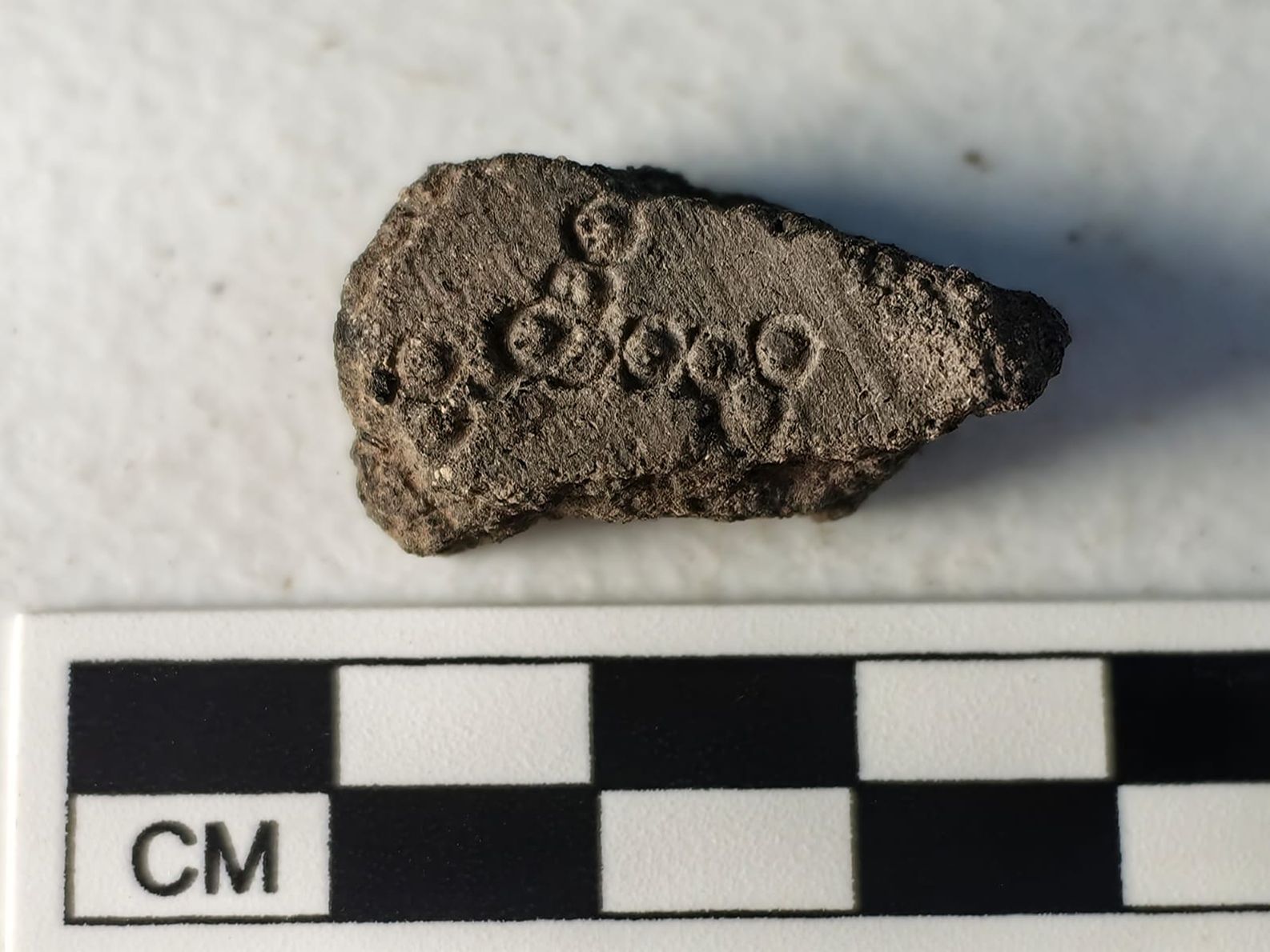
The circle-stamped pottery sherd (Figure 6) excavated from the Layer 10 is small, but the pattern structure suggests that it may indicate external lozenge or net-like lattice patterns, which is considered to be the younger type (type 1) of circle-stamped pottery (Bellwood et al. Reference Bellwood, Dizon, de Leon, Bellwood and Dizon2013) based on the result of the excavation of the Anaro 3 site in Itbayat Island. In terms of date, it is thought to be between 500 BCE and CE 1 (about 2.45–1.95 cal ka BP), a period when nephrite ornaments were intensively produced (Bellwood et al. Reference Bellwood, Dizon, de Leon, Bellwood and Dizon2013).
Photo of pottery shard (National Museum collection number: II-2024-V-142) excavated from the Reydante Cabizon Property Site. Photographed by Eusebio Dizon.

The pottery shard with the identical type of the pattern which has external lozenges or net-like lattice pattern, was found in Yingpu site in western Taiwan (Bellwood and Dizon Reference Bellwood and Dizon2005). Meanwhile, the pattern on the sherd found in Anaro site was executed on the outer surface of the rim sherd, the pattern on the sherd found in Yingpu site was executed on the upper body shard. Additionally, the former is red-slipped, whereas the latter is black pottery.
On the other hand, the pottery with a similar pattern was also found in the Magapit shell midden site of the Lal-lo shell middens in the lower reaches of the Cagayan River in northern Luzon (Ogawa and Aguilera Reference Ogawa and Aguilera1992; Tanaka Reference Tanaka1999; Tanaka and Ono Reference Tanaka, Ono, Ono, Nagatsu and Intoh2018). However, the lozenge pattern of the pottery of the Magapit shell midden is not double but single and executed between the horizontal bands of the incised nail-like impressions on the upper, middle and lower body of the pottery. Moreover, some of lozenges of the pottery were disconnected both right and left sides of lozenge. This is probably because the lozenges were executed as double wavy lines. These lozenges are probably assumed the simplified type of lozenge. The pottery found in the Magapit shell midden site is red-slipped.
The presence of metal and glass artifacts at the Reydante Site suggests a broader occupatinal range extending into the Metal Age, and therefore artifacts excavated from Layer 10 at the Reydante Site can be thought to date to around 4–2 cal ka BP, the period confirmed in the Batan Islands. Therefore, the tephra ages obtained this study are highly consistent with the archaeological chronology.
Conclusions
This paper identified at least five (5) Holocene tephra units—Rolling Hills, San Antonio, Mahatao, Basco and Boulder Beach—based on stratigraphy and radiocarbon dating that erupted from Iraya Volcano at the northernmost of Batan Island. At the Reydante Cabizon Property Site, a cultural layer was intercalated between San Antonio and Mahatao tephra units. The median probability of the calibrated calendar year is ca. 12.4 cal ka BP for the Rolling Hills, ca. 4.5–4.9 cal ka BP for the San Antonio, ca. 2.1–2.5 cal ka BP for the Mahatao, ca. 1.6 cal ka BP for the Basco and ca. 1.2–1.6 cal ka BP for the Boulder Beach tephra units, respectively. The Mahatao tephra (ca. 2.3 cal ka BP) may represent a separate eruptive phase as suggested by the age of the enclosed soil layer (1.7 cal ka BP). At the Reydante Cabizon Property Site (Loc. 4), a double animal-headed ear pendant and circle-stamped pottery shard (Figure 5) have been excavated from thick cultural layer (Layer 10) between San Antonio and Mahatao tephra units.
Acknowledgments
We would like to thank the cooperation of the Provincial Governor’s Office of Batanes, the National Commission of Indigenous Peoples-Batanes, the Provincial Environment and Natural Resources Office-Batanes, and the Mines and Geosciences Bureau Central Office. Mr. Reydante Cabizon and the Archaeology Division Museum Technicians, Mr. Dante Posadas and Ms. Rose Ann Proton assisted with the archaeological excavation. We regret to share that Dr. Eusebio Dizon, a co-author of this paper, passed away on April 23, 2025, before its publication. The research project in the Batanes would not have been possible without his invaluable contributions. We extend our deepest gratitude and heartfelt condolences and dedicate this paper to his memory. This paper was greatly improved thanks to comments from anonymous reviewers and the editor. Part of this research was funded by Grant-in-Aid for Scientific Research from the Japan Society for the Promotion of Science (Project Numbers: 18K0032; 23KK0017).