

PREVIOUS RESEARCH INTO THE ORIGINS OF METAL MINING IN BRITAIN
Ideas as to the antiquity of metal mining and the recognition of ancient or prehistoric workings is not the sole prerogative of modern archaeologists or geologists but, more often than not, owe their origin to the visits of mineral surveyors and antiquarians who witnessed the re-opening of old abandoned workings at the beginning of the modern industrial period. Thus, in 1744, the Crown Mineral Agent Lewis Morris describes his workmen finding the remains of stone mining tools in opening up the old Twll y Mwyn mine near Penryhcoch in mid-Wales, suggesting that it was ‘… wrought in the beginning of times, and before the use of iron was found out’ (Bick & Davies Reference Bick and Davies1994, 37). A little later, during the great working of the Parys Mountain Copper Mine on Anglesey in 1796, Sir Christopher Sykes in his journal described similar remains as being of a date ‘… before Iron was used in this Kingdom’ (Sykes Reference Sykes1796). Meanwhile, at Alderley Edge in Cheshire, discoveries of ancient pit workings and stone tools uncovered during mining operations at Brynlow in 1874 were described by Prof. William Boyd Dawkins as ‘… point(ing) back to the bronze age, when the necessary copper was eagerly being sought throughout the whole of Europe’ (Dawkins Reference Dawkins1875, 79).
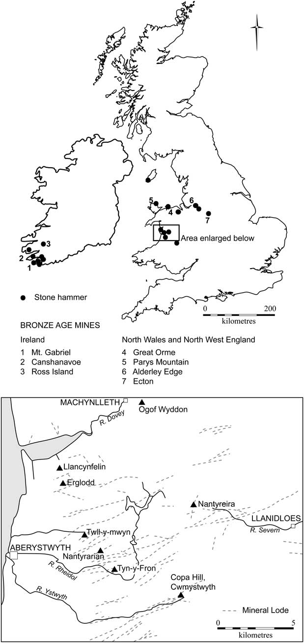
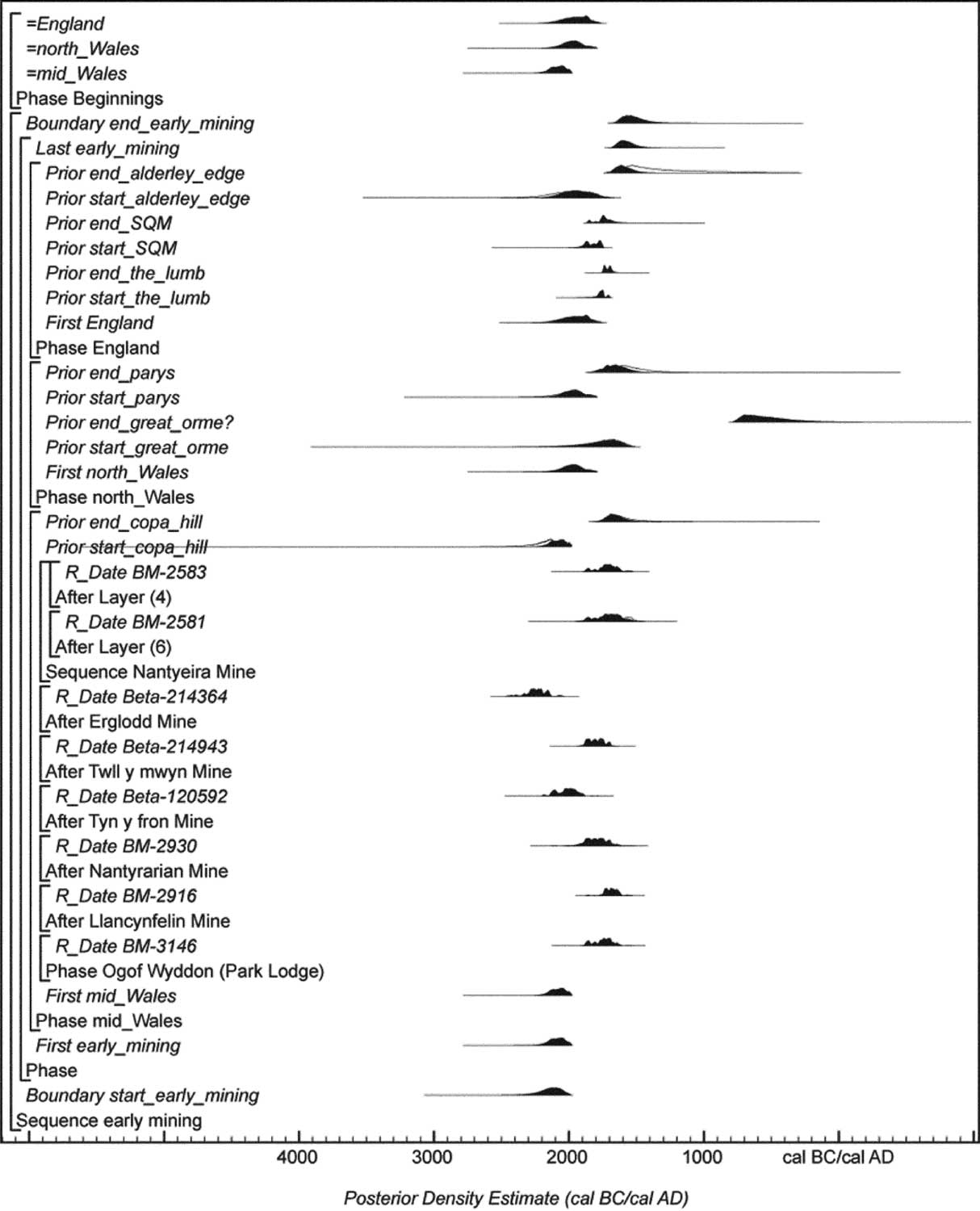
During the Victorian mining boom reports of ancient workings and ‘Roman’ mines in Britain were not uncommon within the pages of the Mining Journal, and these findings were also mentioned in specialist geological reports (Smyth Reference Smyth1848). It was this accumulated body of evidence that prompted the first systematic archaeological survey of ancient mining in the 1930s, undertaken by Oliver Davies on behalf of the British Association for the Advancement of Science (Section H) following the establishment of a committee in 1935 to investigate the evidence for early mining in Wales (Davies Reference Davies1937). A number of sites were investigated (Cwmystwyth, Nantyreira, Great Orme, and Parys Mt : see Fig. 24 below) yet, in the absence of datable artefacts or an independent means of dating, Davies ended up comparing these mines to those of known Roman date in which such tools had turned up in disturbed context. Right up until the mid-1980s the lack of any clear-cut evidence for prehistoric exploitation meant that opinions as to the use of Irish or continental sources of copper during the British Bronze Age (Coghlan & Case Reference Coghlan and Case1957), or else the scavenging of copper from surface deposits (Briggs Reference Briggs1988), persisted. With the arrival of the very first Irish radiocarbon date from the primitive mines on Mount Gabriel, Co. Cork (Jackson Reference Jackson1968) views began to change. In 1986 the first proof of Bronze Age mining in Britain appeared following underground reconnaissance on the Great Orme's Head, Llandudno (James Reference James1988).
Mining hammerstone finds & Bronze Age mines with dates in the British Isles (ST & bc)

Other investigations of potential mining sites were taking place at Alderley Edge (Gale Reference Gale1989) and in mid-Wales and, within the space of a few years, preliminary excavations carried out at Cwmystwyth (Timberlake Reference Timberlake1987), Parys Mountain, and Nantyreira on Plynlimon (Timberlake Reference Timberlake1988) returned Bronze Age radiocarbon dates from sections cut through undisturbed mine spoil. These and other investigations were being undertaken by the newly-formed Early Mines Research Group, while from 1988 onwards excavations were being carried out on the Great Orme by the Gwynnedd Archaeological Trust, the Great Orme Exploration Society, and from 1991 the Great Orme Mines Ltd (Dutton & Fasham Reference Dutton and Fasham1994; Lewis Reference Lewis1994; Reference Lewis1996; David Reference David1998; Reference David2001). As part of the development of this as a heritage attraction, the Pyllau opencast was emptied and hundreds of metres of underground passage within the limestone opened up, making this the largest complex of Bronze Age mineworkings in Britain. The mine was worked using only bone and stone tools and spans the Early–Late Bronze Age. The very latest dates are Early Iron Age.
In the 1990s, as a result of development work carried out by the mining company on the Parys Mt in Anglesey, a number of the shafts were uncapped and access to the underground workings was permitted for the first time. Following exploration here the locations of five, possibly six sites of Early Bronze Age working were identified on the North Discovery Lode in Parys Mine (Jenkins Reference Jenkins1995) and another in the Mona Mine, and archaeological work continues. In mid-Wales, a series of excavations within the Comet Lode Opencast, Cwmystwyth (1989–2002) confirmed a fairly undisturbed site with surviving waterlogged wooden remains, including oak and alder drainage and washing launders (one of them in situ), alongside the remains of a withy handle used a hammerstone, rope and baskets, wood fuel for firesetting, pit props, and several antler picks. Excavations reached a depth of over 10 m. Upwards of 5000 metric tonnes of rock had been removed in the period 2000–1600 cal bc, though it is probable that only the oxidised copper minerals associated with chalcopyrite were extracted during seasonal campaigns of work (Timberlake Reference Timberlake2003). The discovery of a gold disc associated with what appeared to be a Beaker grave at the foot of Copa Hill in 2002 raised some interesting questions as to just who was mining, and what influences there were behind the first prospecting for metals early during the 2nd millennium cal bc (Timberlake Reference Timberlake2002a; Reference Timberlake2009a). Another six Early Bronze Age mines (Llancynfelin, Twll y mwyn, Ogof Wyddon, Erglodd, Nantyrarian, and Tyn y fron) have now been archaeologically investigated in mid-Wales, most of them little more than prospecting sites (Timberlake Reference Timberlake2009b).
The link between Ireland and mainland Britain is interesting in this respect. The earliest identified copper mining took place at Ross Island in Killarney. Excavations (1992–6) revealed a Beaker mine and mining camp and indications of smelting (O'Brien Reference O'Brien2004). The exploitation of a fahlerz ore (tennantite) beginning around 2400 cal bc provided a very distinctive arsenical copper signature to the smelted metal; we can trace the spread of this from Ireland, through Scotland, to England as the arsenic in the metalwork became diluted (Bray Reference Bray2012). By 1800 cal bc this signature had changed; more tin bronzes were now being produced using British copper and alluvial tin from south-west England (Rohl & Needham Reference Rohl and Needham1998). Production at the Ross Island mines finally ceased around 1800 cal bc, with widespread prospection for new sources of ore between 2000 cal bc and 1800 cal bc. In Ireland, the poorer ores of Mt Gabriel (O'Brien Reference O'Brien1994) and the other primitive mines of south-west Cork (O'Brien Reference O'Brien1996) began to be exploited soon after and, following that, mines along the western seaboard of Britain were worked 1800–1600 cal bc. Some of these, however, were worked 200–400 years earlier. Stone tools have also been found at the copper mines of Bradda Head (Pickin & Worthington Reference Pickin and Worthington1989) and Langness (Doonan & Eley Reference Doonan and Eley2000) on the Isle of Man, an indicator, perhaps, of the route once followed by metal and metal prospectors from Ireland into Britain (Timberlake Reference Timberlake2009a).
Perhaps the most remarkable find in recent times is that of the ephemeral remains of Bronze Age copper smelting carried out at Pentrewyn on the Great Orme's Head, Llandudno (Chapman Reference Chapman1997). This is the only example we have of such a site in Britain, and we still know very little about it. No actual hearth has been found, yet we know they were producing prills of smelted copper here, many of which appear to have been extracted from the crushed slag. Whilst all the other mines appear to have ceased production before 1500 cal bc, the Great Orme continued producing copper well into the Middle Bronze Age, perhaps supplying a large part of the copper for the Acton Park metalwork (Rohl & Needham Reference Rohl and Needham1998).
During the Early Bronze Age this search for ore spread eastwards into England. Archaeological work carried out at Engine Vein, Alderley Edge, Cheshire (1997–9) exposed an undisturbed Early Bronze Age pit working dating to c. 1900 cal bc, whilst other probable Bronze Age pits and opencasts, all exploiting malachite-rich sandstone, have been found nearby (Timberlake & Prag Reference Timberlake and Prag2005). Alderley Edge is unique in Britain for the occurrence of large numbers of grooved stone mining hammers. In 1874 an oak shovel was found within one of these workings; miraculously this artefact survived and in 1995 was radiocarbon dated to the Early Bronze Age (Garner et al. Reference Garner, Housley and Prag1994). Recent synchroton analysis of the object appears to confirm that this was used for the shovelling of copper ore (Smith et al. Reference Smith, Green, Charnock, Pantos, Timberlake and Prag2011). The Ecton Copper Mines lie 25 km to the south-east of Alderley Edge.
Ecton Hill: An Introduction (John Barnatt & Simon Timberlake)
Topography and land-use
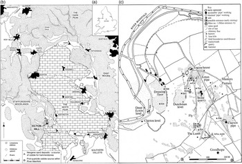
The Ecton Mines lie between Warslow and Wetton in the Staffordshire Moorlands, in the western part of the Peak District of England (centred SK 099 581 (Fig. 1). Ecton Hill is the north-westernmost ridge at the western edge of the limestone plateau in an area of the Peak District south of Hartington, where an arc of high hills extend the plateau further westwards compared with further north. The hill itself, while part of this chain, stands out as, visually, it protrudes northwards in to the surrounding lower ground. While these hills have long supported rough grazing with thin soils and rock outcrops, at the other extreme there are broad areas of the limestone plateau, particularly around its villages, which are more advantageous. Up until the 20th century the latter were used for mixed farming and, in the medieval period, had large open fields. From the Hartington area northwards the limestone plateau is flanked at its western edge by the River Dove, which, further south, runs through a gorge, and further west there are precipitous valleys where the River Manifold and River Hamps bisect the plateau.
a. Map showing the location of Ecton; b. Ecton in relation to nearby towns/villages; the location of the hammerstone sources are indicated; c. Ecton Hill showing locations of Stone Quarry, Ecton Pipe, and The Lumb, the mineral workings, distribution of hammerstones (2008 survey), and other topographical features; after Barnatt Reference Barnatt2012a: modified by Brenda Craddock (bc) & Simon Timberlake (ST)

The hill at Ecton lies immediately east of the River Manifold. It comprises a steep-sided limestone ridge c. 2.5 km long and up to 1.3 km wide, rising up to c. 270 m above the river at its western flank (Fig. 1c). The known mineralisation is confined to the northern half. Much of the steep western side of Ecton Hill and its crest have well preserved mining remains, mainly because of long-standing non-intensive upland grazing.
The Manifold valley running south from Ecton comprises a deep and steep-sided cut through limestone, sometimes with cliffs, with a river that only runs seasonally from Wetton Mill to Ilam. There are many small caves containing prehistoric and later archaeological and palaeo-environmental material. On the limestone plateau to the east of Hartington and the River Dove, one area has solution hollows filled with Neogene sand and gravel deposits, an important potential source for hammerstones (Fig. 1b).
Historic metal mining
The Ecton Mines, as well as having small prehistoric copper and medieval lead mines, were extensively worked in post-medieval times, primarily for ores of copper and lead, but including zinc (Porter & Robey Reference Porter and Robey2000). Archaeologically these remains are of national importance and form an invaluable research and interpretation resource.
The 17th century saw small scale work at several mines across the hill, one of which is of some importance today because of the evidence for the early use of gunpowder, thought to date to ad 1665–8 (Barnatt et al. Reference Barnatt, Rieuwerts and Thomas1997). The scale of mining increased exponentially from 1723 onwards. At Deep Ecton Mine exceptional deposits below river level were reached by the middle of the 18th century and, from 1760 onwards, the Duke of Devonshire, who had previously leased the mines, took them in-house. For 30 years they earned the Dukes a fortune but, in 1790 at 300 m below the river, the pipe failed. The other deep working, Clayton Mine, which for most of its life was under a different ownership, was worked to a similar depth in ad 1805–1825. During this period the Dukes took on mines across the hill and worked them together in an attempt to revitalise mining. Eventually all the mines became unprofitable and the venture was abandoned. However, throughout the remainder of the 19th century, mining was nearly continuous but undertaken by private companies sometimes working with modest but not very profitable success. The last mining took place in 1889 (Porter & Robey Reference Porter and Robey2000; Barnatt Reference Barnatt2013).
Ecton's archaeological legacy is impressive. Apart from a large number of shafts and ‘pipe-deposit’ entrances along the ridge-top, there survive mine hillocks associated with the remains of levels, dressing floors, and valley-bottom smelt works, plus the all-important entrances to the Deep Ecton and Clayton Mines. In addition there are a number of important standing and ruined mine buildings.
Many of the extensive underground workings are still accessible above river level and include underground chambers for steam-, water- and horse-powered engines, and several major levels for haulage and drainage. One such level was used as an underground canal, while another let water into the mine to operate pumps (Barnatt Reference Barnatt2013).
Lead ores were extensively mined in the Peak District from Roman times into the 20th century, the richest deposits being in Derbyshire, on the limestone plateau some distance to the north and east of Ecton. In contrast, copper mines are rare. There is one possible exception, a small vein that was relatively rich in copper ore at Dene Quarry near Cromford (SK 287563), unfortunately now fully quarried away. Some years ago a small private collection of cobbles from this mine was inspected by John Barnatt, but none appeared to have been used as a hammerstone.
People in prehistory
In the 4th–2nd millennia cal bc the Peak District was a core area of population in Britain (Bradley Reference Bradley1984; Barnatt Reference Barnatt1996a; Reference Barnatt1999). There is a range of Neolithic chambered tombs, long barrows, and henges. An exceptional number of later Neolithic and Early Bronze Age round barrows are particularly common on the limestone plateau, with the highest density to the south-west in the topographically dissected areas with rich plateau-top limestone soils running south from Ecton (Barnatt Reference Barnatt1996b; Reference Barnatt1999). In contrast, the shale-dominated lowlands north of Ecton, and the gritstone uplands to the west, have far fewer barrows, even when differential destruction rates are allowed for. The barrows have the usual wide variety of inhumation and cremation rites and grave goods. Multiple burials are common, often with no one specific grave being ‘richer’ than others; a superficial picture to the contrary is significantly biased by the preconceptions of antiquarians such as Thomas Bateman who dug small holes at many mound centres and stopped digging once he had found what he considered the important grave. Similarly, analysis of the distributions of barrow on the eastern gritstone moors, where survival is exceptionally good, shows that every local farming group had its own monuments, rather than barrow burial being the preserve of elite groups (Barnatt Reference Barnatt2000). As elsewhere, a proportion of the barrow graves contain Beaker and Early Bronze Age bronze objects, such as axes, knives, and pins (Vine Reference Vine1982). No significant archaeological evidence for bronze production in the form of smelting sites or casting moulds has been discovered locally, although this is not to say it did not take place.
Direct evidence for Neolithic and Early Bronze Age settlement in the Peak is rare. However, the high density of barrows shows that people were plentiful, with the evidence pointing to a complex palimpsest of seasonal uses following traditional rights of tenure over broad areas of the region (Barnatt Reference Barnatt1996a; Reference Barnatt1999; Reference Barnatt2008). Some place were suitable for home bases for overwintering, others would be used only at other seasons. In the Late Neolithic and Bronze Age there is evidence for an increasingly sustained use of particular locales for farming, but when permanent settlement and concomitant changes in emphasis on ownership of land became the norm is still a matter for debate.
The archaeological material in caves in the Manifold Valley indicates a variety of ritual, refuge-habitation and casual use in prehistory and later (Bramwell Reference Bramwell1973; Barnatt & Edmonds Reference Barnatt and Edmonds2002). Although there is good archaeological survival, the cave data is a relatively minor part of the story of the region.
Ecton Hill: Previous Research Into Prehistoric Mining (John Barnatt)
19th century collecting
The Duke of Devonshire's rich copper mines at Ecton have been widely known since the 18th century, but it is only since the 1990s that the presence of prehistoric mining started to come into focus. Ancient mining tools were collected by miners in the 19th century, presumably found when they broke into old workings or perhaps on hillocks, but this was never widely advertised. A small collection of hammerstones survives in Thomas Bateman's collection at Sheffield City Museum (Howarth Reference Howarth1899; Guilbert Reference Guilbert1994b; Pickin Reference Pickin1999). A label also refers to ‘sharpened pieces of stag's horns’ which have not survived and notes all the discoveries were made in June 1855 ‘in’ rather than ‘at’ an ‘ancient mine’. This wording perhaps suggests they were found underground. It may well be that they were handed to Samuel Carrington, Bateman's main compatriot in digging Peak District barrows, who lived in Wetton, not far from the mines. The finds remained unpublished and were not relocated in the museum collection until 1991. The 1855 discovery date is interesting, for the Ecton Mountain Mining Company, who worked mines over the whole hill from 1851–7, had a different operational focus compared with previous mining companies, placing greater emphasis on reworking shallow mines rather than ore extraction at greater depth. Unfortunately, where on the hill the hammers were found in not specified; while individual mines are mentioned in the Company account books whenever development work was being paid for, the places from where ore was being raised and hillocks reworked is not given (Barnatt Reference Barnatt2012a). However, one likely possibility is ‘Dutchman Mine’ (today known as Stone Quarry Mine), where the Company was doing development work between Nov. 1853 and Dec. 1854, perhaps continuing to raise ore in 1855. Similarly there is good evidence to suggest that a trial level, with a now collapsed portal where John Pickin found hammerstones at surface in 1997 (see below), that ran to the main Deep Ecton pipeworkings at c. 11 m below surface, was driven in Nov. 1853–Jan. 1854 (Barnatt et al. Reference Barnatt, Rieuwerts and Thomas1997; Barnatt Reference Barnatt2012a). Work in the main pipe undertaken after the level was finished may offer an alternative source for the hammerstones. It is perhaps interesting to note that the 1855 discovery of stone tools at the Ecton mines was a good deal more widely known than previously thought, for in the Reference Guilbert1863 Handbook of Llandudno John Hickens compares the Great Orme finds with those from Ecton Hill, claiming that the mines ‘… were worked by the Ancient Britons, long before the Roman invasion’.
20th century discoveries
In 1994 the discovery of four further hammerstones found on the Dutchman Level/Goodhope Level spoil tip was published (Guilbert Reference Guilbert1994a). While the 18th century Dutchman Level links with significantly earlier workings above, the hillock here was much enlarged in the 1850s–60s with the driving of the long Goodhope Level to the New Trial (now known as Fly Mine and not intersecting recognisable earlier workings (Barnatt Reference Barnatt2012b)), Goodhope Mine and Bag Mine, the last two on the far side of the hilltop. Other material on the hillock may have been added that was derived from the 1850s’ working of the Dutchman Mine noted above. The possibility that the 1855 and 1994 hammerstones came from the far side of the hill rather than Dutchman Mine cannot be fully discounted, but no hammerstones have been found on the surface hillocks here. Those in Sheffield Museum were assessed by John Pickin in 1999, who identified eight utilised quartzite cobbles, another example in gritstone, and a possible one in limestone (Pickin Reference Pickin1999). Those recorded by Guilbert in 1994 included two described as metaquartzite or ganister, and two others that were of coarse sandstone.
In the 1990s a small number of further hammerstones were identified on the hilltop. In 1997 John Pickin found examples from below Ecton Pipe, at Stone Quarry Mine, and The Lumb (see below; Barnatt & Thomas Reference Barnatt and Thomas1998). Further hammerstones were identified on the hill in the same areas by Garth Thomas and shown to John Barnatt in the mid-1990s, but these subsequently went missing and are believed to be in private hands.
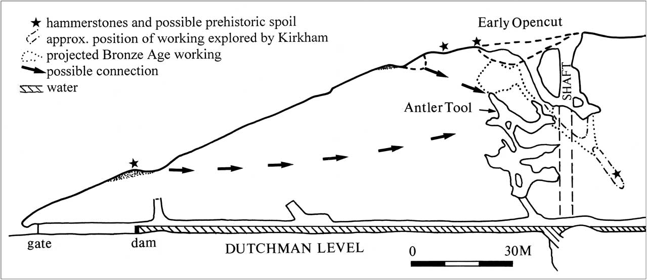
In 1994, Trevor Ford, then editor of the Bulletin of the Peak District Mines Historical Society, reported that unpublished 1945 explorations of Stone Quarry Mine were recorded in notes and a letter written by the pioneer mine historian Nellie Kirkham (Guilbert Reference Guilbert1994a). These described what may well have been four hammerstones and a possible bone tool, placed on a ledge in the southern part of Stone Quarry Mine. Attempts to re-enter this working and assess the potential tools began a long involvement in Ecton for John Barnatt. In an initial search it was discovered that the way to where the tools were found in 1945 has irrecoverably collapsed. However, evidence for early gunpowder blasting was found, in the form of exceptional shot holes of continental type, and probably dating to 1665–8 (Barnatt et al. Reference Barnatt, Rieuwerts and Thomas1997). Eventually a search of the hilltop workings for other evidence of early mining led to the discovery of an antler mining tool, found in post-medieval backfill by Bob Dearman and Garth Thomas high above Dutchman Level and about 11.5 m below the top of northern inclined entrance passage at Stone Quarry Mine (Barnatt & Thomas Reference Barnatt and Thomas1998). The two workings were linked in 1945 but the way between them was choked by the 1990s. The antler was radiocarbon dated to 3445 ± 35 bp; 1880–1630 cal bc (OxA-7466). The distribution of known hammerstones on Ecton Hill suggested the presence of two zones of prehistoric mining; one centred on the Deep Ecton Pipe/Dutchman Mine and the other on The Lumb. These findings have since been supported by the work of the Ecton Mines Project (2008–9) reported here.
The Ecton Mines Project
As John Barnatt's interests in Ecton developed, he and Garth Thomas started multi-period assessment of several of the mines, including extensive survey work in Deep Ecton Mine and Salts Level. In the late 1990s an Ecton Mines Project, with funding from English Heritage, was first mooted, but it was not until 2007, with a new management trust on site (at the Ecton Education Centre), that it became possible for this project to begin; this undertaking led by Barnatt encompassed a multi-period detailed appraisal of the mines which included a survey of earthworks, a selection of mine buildings, and a series of further underground surveys (Barnatt Reference Barnatt2012a; Barnatt Reference Barnatt2013).
One of the smaller underground assessments was carried out on The Lumb where all of the choked workings were surveyed. This resulted in the tentative recognition within one of the small passages of potential prehistoric extraction undertaken using stone and antler tools (Barnatt Reference Barnatt2012b). Survey work was complemented by two evaluations: one looking at the character of the prehistoric extraction on Ecton Hill, reported here, while the second, a geophysical and geochemical-based search for the evidence of prehistoric ore processing led by Roger Doonan of Sheffield University, failed to find any indications of this activity within the extensive areas examined (Doonan Reference Doonan2010).
Mines in the vicinity of the prehistoric workings
All of the prehistoric mines are likely to have been concentrated on the ridgetop and have been relatively shallow compared with what came later (Fig. 1c). At the main Deep Ecton Pipe, which became extremely rich at depth, there has been intensive multi-period working in the upper parts. The ore outcrop is surprisingly small, with a capped steeply-inclined entrance that is less than 5 m across; it can be entered at 20 m down where a shaft joins, but all is choked at 9 m below. Post-medieval reworking and hillock removal means that there are no signs of recognisable prehistoric work, although hammerstone have been found scattered across the general area.
The Stone Quarry Mine (also known as the Dutchman Mine) was extensively reworked in post-medieval times, but hammerstones present in the hillocks shows that there were prehistoric workings here. There are also two open entrances into steeply inclined workings, alongside the remains of several 18th and 19th century shafts, and below this the Dutchman Level at the top of a massive hillock. This adit connects up with workings which rise more than 35 m to the ridgetop above. The two ridgetop entrances are particularly interesting in that there is evidence for 17th century powderwork, but also earlier origins. Both entrances were completely sealed beneath later spoil, but these then opened-up during the 20th century when whatever was supporting the fills collapsed; the northern entrance sometime in the 1920s–40s, and the southern in 1963. During the 1990s the Stone Quarry workings could only be entered 17 m below surface, but in the 1940s they could be followed to about 30 m.
While workings on The Lumb have been reworked since prehistory, some of what is visible today may have Bronze Age origins. A series of hollows forming a shallow trench, with associated upcast hillocks, runs diagonally down the steep upper western slope of Ecton Hill. From its updip side several small and largely choked underground workings then follow the dipping bedding planes downwards. Nearby there are hillocks upon other veins which run straight downslope, and where the analysis reported here indicates medieval work associated with lead extraction. Where all these workings come together at the ridgetop, adjacent to a round barrow, the mining remains have been badly disturbed by a small limestone quarry associated with a limekiln.
Other mines extend further east and south along the ridgetop, including the large Clayton Mine pipe outcrop, where currently there is no evidence of prehistoric exploitation.
The Geology & Mineralogy of the Ore Bodies Worked in Prehistory & At the Bronze Age Extraction Sites (Simon Timberlake & Norman Moles)
A geological background of Ecton Hill & the Ecton Mines
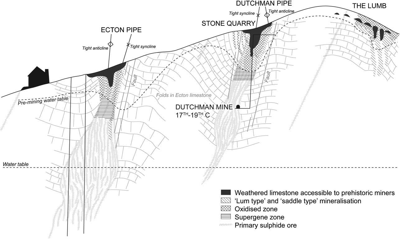
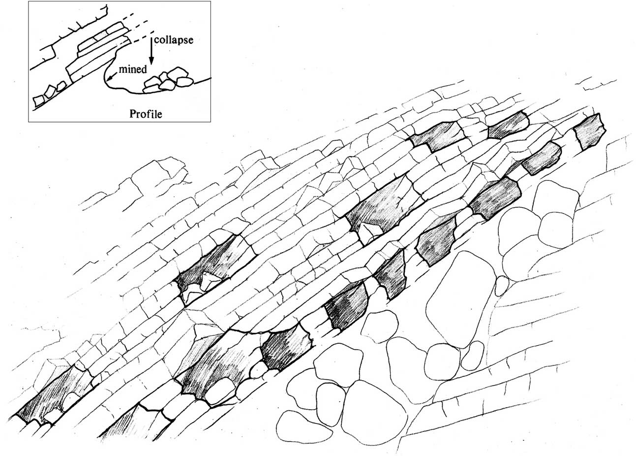
Ecton Hill at surface essentially comprises Lower Carboniferous Limestone of the commonly thinly-bedded Ecton Limestone Series, with the Milldale Limestone beneath, the latter rocks mostly encountered during deep mining (Robey & Porter Reference Robey and Porter1972; Critchley Reference Critchley1979; Ford Reference Ford2000; Porter & Robey Reference Porter and Robey2000). There are also occasional thin beds of chert, mudstone, and weathered volcanic ash (here altered to clay). All of these beds have been subjected to significant folding, resulting in the formation of many small-scale anticlines and synclines; and as a consequence the rocks now lie at a variety of different angles. The severity of this folding has meant that many of the beds which lie close to the intersections with the main ore bodies are similarly steeply inclined, in some cases close to vertical (Fig. 2). To complicate matters further there are several geological faults which have fractured and displaced some of these beds; some of these faults run right across the hill, but others are much more localised.
A schematic cross-section through Ecton Hill showing folding of the limestone beds, location of faults & mineral veins, & principal ore deposits including Ecton Pipe, Dutchman Mine, & The Lumb. Suggested location of pre- & post-mining water table & approximate positions of primary sulphide, supergene, and oxidised zones (after Ford Reference Ford2000) indicated, & locations of Bronze Age extraction (bc & ST)

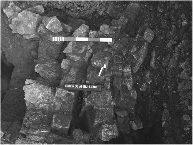
Vertical limestone beds & voids present within the anticlinal fold (‘saddle’) exposed in excavation (Trench A1) at Stone Quarry Mine (ST)

Mineralisation is present in a variety of different contexts. Minor deposits of no great economic worth (from a modern perspective) are commonly to be found along faults and between steeply inclined bedding planes. Occasionally we see minor palaeokarst enlargement (solution cavities) within the limestone which are filled with mineral, yet in other places there has been replacement of the actual limestone within certain of the beds by minerals such as dolomite and silica. At Deep Ecton and Clayton Mines the folding is so severe and intersected by faults that the mineralisation has become densely concentrated within near-vertical zones of ore enrichment, otherwise known as ‘pipeworkings’. Most of this mineral has been deposited in voids in the rock resulting from the extensive fracturing of the beds which form the apexes of the anticlinal and synclinal folds. Associated with some of these voids are vughs (large crystal-lined cavities).
The primary mineralisation at Ecton is Late Carboniferous (c. 290 million years), with secondary mineralisation taking place during the Late Tertiary period (2–3 million years ago). On account of its complexity it has been argued that this may have a different origin to the lead-dominated orefield found further to the east over much of the Peak District (Critchley Reference Critchley1979; Ford Reference Ford2000). At Ecton copper, lead, and zinc ores were common, but varied in quantity from mine to mine, with lead and zinc tending to increase with depth. The common primary ores were chalcopyrite and bornite (both copper iron sulphides), galena (lead sulphide), and sphalerite (zinc sulphide) (see Ford et al. Reference Ford, Sarjeant and Smith1993). In addition, there were a number of secondary ores, often found as oxidation coatings on the primary minerals; these are malachite and azurite (hydrous copper carbonates), cerussite (lead carbonate), and smithsonite (zinc carbonate). Common gangue (non-metallic) minerals were calcite (calcium carbonate), barite (barium sulphate), and sometimes fluorite (calcium fluoride).
For reasons that are not totally understood, Ecton Hill is unique in that the other prominent limestone hills nearby have only relatively minor, or no, mineralisation. This includes the nearby Dale Mine on the opposite side of the Manifold, which produced only lead ores, and others just over 5 km further distant, hidden away in high limestone-shale country, the best known of which is the copper mine at Mixon. Lead mines occur 4 km south of Ecton on the east side of the Manifold at Bincliffe.
Stone Quarry Mine
The form of the mineralisation on this part of Ecton Hill was referred to by Plot (Reference Plot1686) shortly after the northern part of the ridgetop had been worked. Plot observed of the copper ore workings that: ‘the workmen being disperst I could learn little more concerning it, but that the veins lay from eight to fifty yards deep, but all dipt North-Easterly.’ He also noted that ‘there has been Lead ore dug at Ecton-Hill; where some of it lyes so near the day, that it was first found by the plough’. An 1850 Prospectus Plan appears to support the description of copper workings, as Dutchman Shaft is shown at the intersection of several mineral veins. It was these groups of intersecting east–west (ENE–WSW) and north–south (NNW–SSE) veins (sometimes referred to as stockworks) which formed pipeworkings (such as the Clayton and Ecton Pipes) at their junctions (Kirkham & Ford Reference Kirkham and Ford1967). However, the picture revealed on excavating the top of the Dutchman Mine ore body at Stone Quarry Mine seemed different, in that the opencast here appears to have been dug on a steeply dipping anticline with near vertically dipping detached limestone beds (Fig. 3). The interbedded shale bands seem to have been washed or squeezed out from in between these well-jointed rocks; a situation typical of what is commonly referred to locally as ‘saddle type’ mineralisation (Ford Reference Ford2000). Within this orientation the bedding planes of the folds, not just the joint fractures, would have acted as a conduit to the mineralisation (in the form of rising mineral solutions), and as a result the worked-out ore ground follows the axial plane of this fractured void-filled anticlinal structure. At Stone Quarry some of the smaller beds within the Ecton Limestone have been geologically replaced by a harder but more brittle chert (mineralised silica), yet the open structure of these folded rocks would still have made mining to some depth here a relatively easy task, enabling the digging of workings that were well-ventilated and free-draining. The main type of mineralisation here is to be found within vughs filled with coarsely crystalline calcite which are best developed along the crests (or axes) of the saddle (folds). These vughs carry copper in the form of chalcopyrite and bornite weathering to goethite (hydrated iron oxide), malachite, and aurichalcite (hydrous zinc copper carbonate). This particular mineral association is referred to here as the Type 2 mineralisation (analysis by N. Moles). Malachite is also present in other areas of the saddle working in the form of narrow veins and as joint coatings on limestone (Type 1 mineralisation). Where this malachite has been removed the rock has been finely crushed in the process. Another type, the galena and barite mineralisation (Type 3), was probably extracted during the post-medieval period, yet this appears to be a minor constituent of the ore body present at surface. The single most important factor governing prehistoric exploitation here was the presence of copper within the oxidised zone of minerals surviving above the water table. Within this zone most of the chalcopyrite has altered to malachite, and perhaps also to small amounts of cuprite and tenorite (copper oxides), and native copper, although in addition we see the formation of the supergene minerals bornite, chalcocite, and covellite (both copper sulphides) which were deposited at, or just beneath, the water table within the zone of copper enrichment (Critchley Reference Critchley1979; Ford Reference Ford2000, 23–24; Ford et al. Reference Ford, Sarjeant and Smith1993).
The Lumb
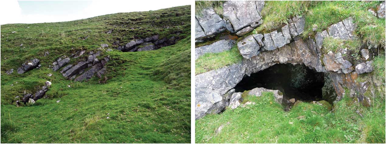
Lum or Lumb is a local term for a natural fissure filled with rock and minerals embedded within a clay matrix (Porter & Robey Reference Porter and Robey2000, 71), its origin most likely being the German word for clay (lehm). Little is known about the structure or working of The Lumb at Ecton, yet at the Mixon, Dale, and Royledge Mines lums were important features forming east–west oriented mineralised fissures (ibid., 257). A lum vein was described as being ‘of great magnitude, and commonly entirely filled with marl and decomposed limestone, although in the immediate neighbourhood of the pipe veins some ore … is attached to the cheeks of the vein’ (Watson Reference Watson1860). The clay present within the lum fill was referred to as ‘flookan’ by the Cornish miners working at Dale, and different from the clay found above the ore in the wings of a saddle, known as ‘whey’ (ibid.). The Lumb at Ecton appears to have been a very small deposit, and there is no evidence at all for any associated pipe-working. Although this is an anticlinal structure, there is little evidence here for a dominance of saddle-type mineralisation. On the eastern limb of this anticline beds of fossil crinoidal limestone with only a little chert, but with clay wayboards (thin beds of clay) in between, dips shallowly to the north-east. Type 1 mineralisation is common here, yet it is fairly well localised and linked to the dolomitisation of a single limestone bed (ie, the partial replacement of this rock by dolomite (calcium magnesium carbonate)), the worked outcrop of which can be traced across the hillslope above. In places this dolomitised limestone consists of a soft weathered rock containing pockets of mineral, mostly ochreous goethite veined with malachite. This appears to be a replacement mineralisation, and it was the only type to be witnessed in situ, although the crushed mineral recovered from the prehistoric mining sediments in Mine No. 1 (see Fig. 10) suggests the extraction also of mineralisation Types 2 and 3. The four cave-like mine entrances and associated workings which overlie this bed (see Figs 12a–b) consist of a series of low partly-natural and partly man-made fissures, presumably part of the lum from which the clay and mineral has been extracted. Traces of this clay fill was still visible within some of these workings, as were a number of now-emptied and vertical mineral-filled solution cavities formed within the limestone by karstic, or perhaps even thermokarstic, action; in the case of the latter explanation, this solution by hot water may have been contemporary with the initial phase of primary mineralisation (Ford 2003). Inevitably we cannot know the exact nature of what was removed here during the Bronze Age and succeeding periods, yet the type mineralisation present within this upper part of The Lumb is much more likely to be of Types 2 and 3 than it is Type 1. For example, abundant discarded galena and calcite were commonly found amongst the spoil dumped within the backfilled workings underneath.
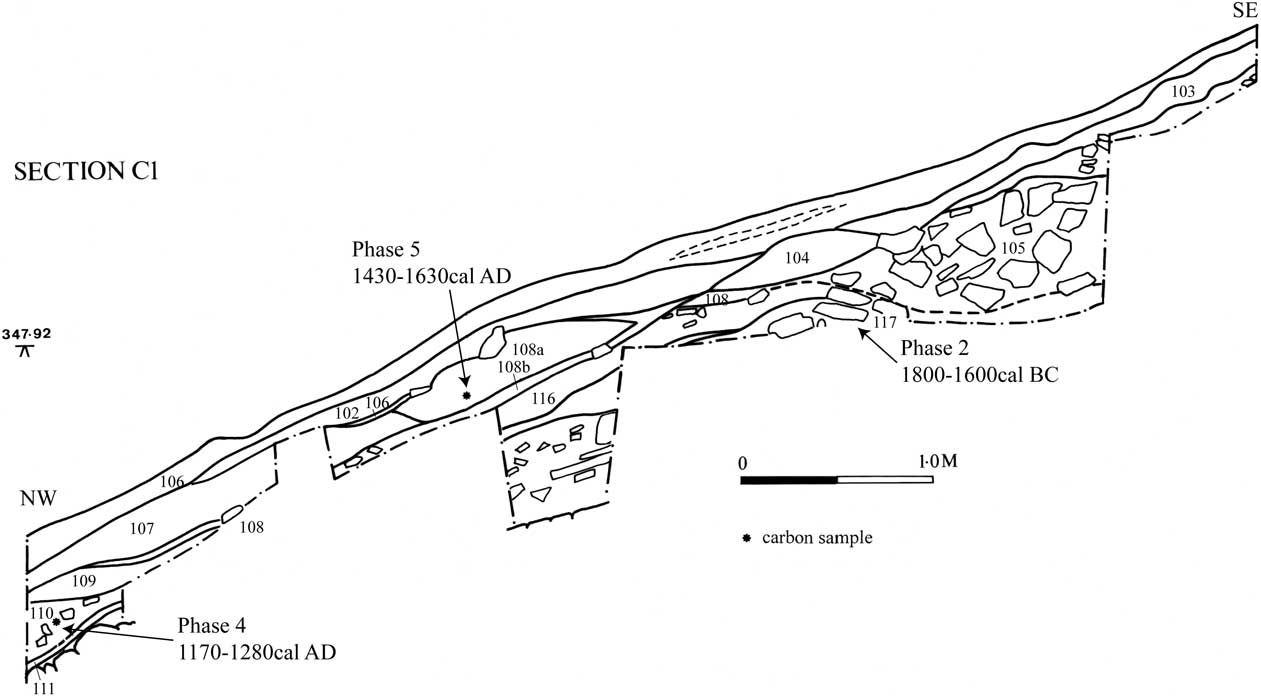
West-facing section of Trench C1, The Lumb (2008), showing medieval lead mining tip with radiocarbon dates indicated

a. Cave-like mine entrances on The Lumb; b. detail of Mine Entrance C (ST)

INITIAL FIELDWORK IN 2008 – HAMMERSTONES FROM ECTON HILL
Archaeological fieldwalking was carried out in April 2008 with the primary objective of looking at the distribution of hammerstones and other surface indications of ‘primitive mining’. A rectangle of land lying between Gate Level and The Lumb and Clayton Pipes (an area of 10.75 ha) was fieldwalked in 10 m transects, whilst two smaller areas of 0.72 ha (The Lumb) and 0.75 ha (Stone Quarry Mine) were examined in greater detail (2 m intervals). Non-transect fieldwalking was carried out over a larger area, stretching from the Deep Ecton Dressing floors in the Manifold Valley, up to the Dutchman Level (ST and JB) then over the top of the hill eastwards to Master's Pasture, and as far south as the Clay, Bowler and Gregory Mines (JB). Hand-held GPS (Garmin GPS 60) was used to plot the hammerstone finds and other features of interest, the findspots were also flagged on the ground for later inclusion in the surface topographic survey of the hill.
During the non-transect fieldwalking three unused, but otherwise suitable, tool-sized cobbles were recovered from the tip areas at Master's Pasture Mine (Fig. 1b), and another one just west of the Clayton Pipe, while a single hammerstone was identified from just above the Upper Dressing Floor of Deep Ecton (this is the only example from this low down on the hill). The most interesting discovery was of a semi-grooved hammerstone on the surface scree-slope of the spoil tip (thus in redeposited context) below Dutchman Level (see Figs 1c & 19: hammerstone E10]. This was from the same area collected by Graeme Guilbert in 1994 (see above; Guilbert Reference Guilbert1994a; Reference Guilbert1994b).
The systematic fieldwalking located a further eight hammerstones: four on the steep hillside slopes above Dutchman Level and up to 100 m downslope of Stone Quarry Mine (Fig. 1c). These were not found associated with any workings or mine spoil, but formed a group within the soil-creep ridges above the trackway down to Dutchman Level. Another four hammerstones were found slightly more widespread and dispersed by soil creep and modern disturbance within an area old trials downslope of Ecton Pipe. The most probable source of (three) of these is a grassed openwork here where John Pickin found three hammerstones in 1997 (see above; SK 09855830), and possibly other small workings nearby.
A small hammerstone and the flake from another tool were found close together in the grass-covered top of an old spoil tip just below Stone Quarry Mine. The finding of a flake fragment with cobble tools was considered to be a good indicator of the proximity of a site of potential prehistoric mining.
South of here, three hammerstones and one unused cobble were recovered from the grassy slopes immediately below The Lumb. One came from outcast associated with the lowest Mine Entrance A (see Figs 9 & 18 (E19)) while the others came from an area of disturbed spoil 10 m to the west. This group forms a localised outlier to the main distribution described above.
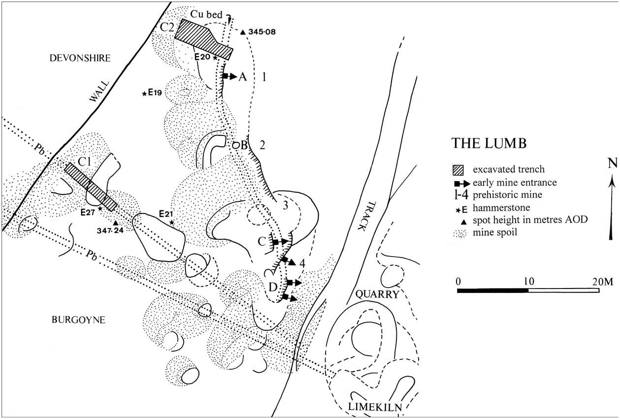
Plan showing lead vein & copper bed mineralisation on The Lumb, 2008 & 2009 trench locations (C1, C2), & positions of Mines nos 1–4 and Mine entrances A–D. Field wall divides historic Devonshire & Burgoyne mining liberties (ST & bc; original survey data in Barnatt Reference Barnatt2012a)

EXCAVATIONS AT ECTON IN 2008 & 2009
Location
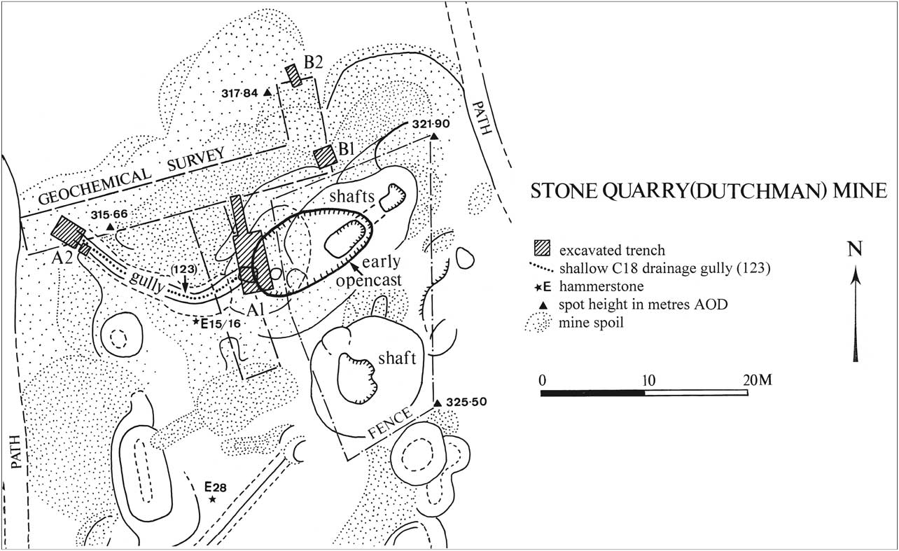
Two separate sites were chosen for excavation based on the pattern and concentration of hammerstone finds. At Stone Quarry Mine (SK09905825) five trenches were opened up in September 2008 in order to sample the area around the early opencast and nearby steeply inclined underground working, to look for traces of prehistoric mining (Fig. 4). The main Trench A1 (10 × 1–3 m) was located along the lowermost western edge of this feature; square A2 (3 × 2 m) 30 m downslope to the west of this within the possible entrance to an adit or open working. Small test-pit squares B1 (2 × 2 m) and B2 (2 × 1 m) both lay to the north of the opencast and 18th century drawing shaft on the tip line of a possible earlier phase of mining suggested by a change from lead to copper/zinc contamination in the soil (the latter was determined by grid-based geochemical sampling using a portable X-ray fluorescence spectrometer (PXRF); info. N. Moles). Excavation on The Lumb (SK09755800; see Fig. 9) was positioned on small mineralised outcrop 250 m to the south-south-west of the Stone Quarry workings on the south-east side of the boundary wall between the Duke of Devonshire and Burgoyne mining liberties. Trench C1 (1 × 7 m) was investigated in 2008. On account of the botanical sensitivity of the site, this trench was positioned 20 m to the south-west of the lowest bedding plane working (Mine No. 1) considered to be a potential site of prehistoric mining. However, the mining evidence uncovered here was confirmed to be associated with a quite different vein system and working. In 2009 with permission from Natural England Trench C2 was excavated in hummocky ground 2–3 m downslope of Mine Entrance A. This was aligned north-west–south-east, measured 8 × 2–3 m (20 m2).
Plan of Stone Quarry Mine showing shafts & approximate position of buried opencast, limits of geochemical survey, sites of excavation trenches, adit cutting & later drainage gully, areas of spoil, & findspots of hammerstones (ST & JB (original survey data))

Stone Quarry Mine (2008)
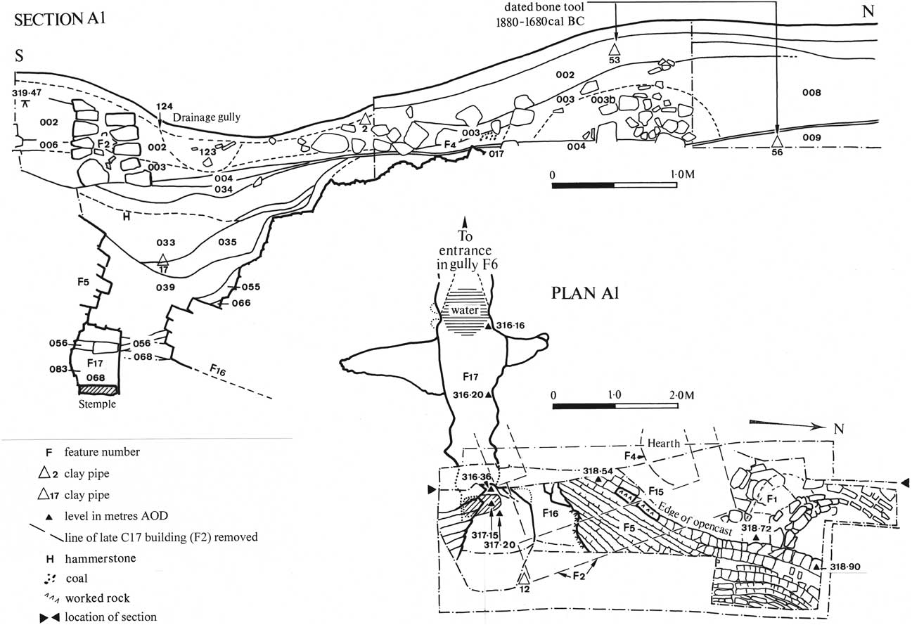
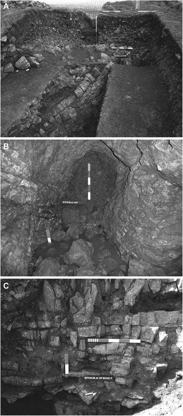
Excavation in Trench A1 commenced with the digging of a 5 m long section through a mine tip just to the west of the steeply-inclined underground working. This revealed a mixed stratigraphy consisting of primary and redeposited mine spoil ((003) (007–009)), the working of which probably dates from the late 7th or early 18th century (Fig. 5). Interestingly layers 003 and 009 contained a number of redeposited hammerstones and bone tools suggesting that the area that the miners were working through consisted of remnants of prehistoric workings. At the north end of this spoil heap the rock outcrop was encountered at 1.5 m depth without finding early mining deposits, but at the south end this spoil covered the north end of an earlier infilled opencast (F.5) (Fig. 6a). The top of this was sealed by a well-trodden working floor (004) associated with the foundations of a late 17th century rectangular building. A section was cut beneath the floor level to reveal 1.25 m of backfilled mine spoil dated through finds of clay tobacco pipe fragments to c.1660–80 (ident. D. Higgins: see Fig. 19 bottom right). Beneath this spoil, covering the weathered sloping rock face of the opencast, was a deposit of humic material (039–040), and beneath that more 17th century mine waste with shot holes sealing earlier traces of prospection (F.15 & F.16) on the walls of the opencut. Intersecting with the base of this 2 m deep opencast (at 317.15 m aOD) was the roof of an earlier hand-wrought gallery (F.17) which had been sealed off with stone slabs prior to the backfill of the opencut in the 17th century. A length of 4 m of this 1–1.2 m high and 0.7–0.8 m wide mine gallery was accessible in a west-south-west direction as far as a blockage close to its exit to the surface (Fig. 6b). About 2 m along this passage there was an intersection with a north-north-west–south-south-east inclined fracture which had been mined c. 0.8 m and 1.5 m in either direction (see Fig. 5), revealing pockets of copper mineralisation worked with some type of hammer (batter marks) as well as with iron picks. While the shape and form of this gallery is somewhat reminiscent of prehistoric working, the surviving evidence, which excludes any trace of shot holes yet includes several hollows crudely worked with metal picks, suggests medieval–early post-medieval mining (Roman mining cannot be fully discounted but there is no evidence for this at Ecton). This was followed the re-use of this feature as a drainage adit in the late 17th century. Other potentially prehistoric (but probably undatable) mining features were encountered in this excavation, including the opencast itself and some of the associated worked mineral pockets (F.18 & F.5; Fig. 6c). Another ‘early’ feature was an intriguing 0.7 m wide crude clay-rock construction (F.1), perhaps built as a water cistern on the opencast edge.
East-facing section of Stone Quarry Mine tip adjacent to infilled opencast, showing position of clay pipe, stone, & bone tool finds; plan of same trench showing underlying medieval/ post-medieval adit working (F.17) which holes into the base of the opencast (bc & ST)

Stone Quarry excavation (Trench A1): a. opencast at surface; b. cross-section of collapsed end of ancient mine adit (F.17); c. early mining feature (F.15) in side of opencast (ST)

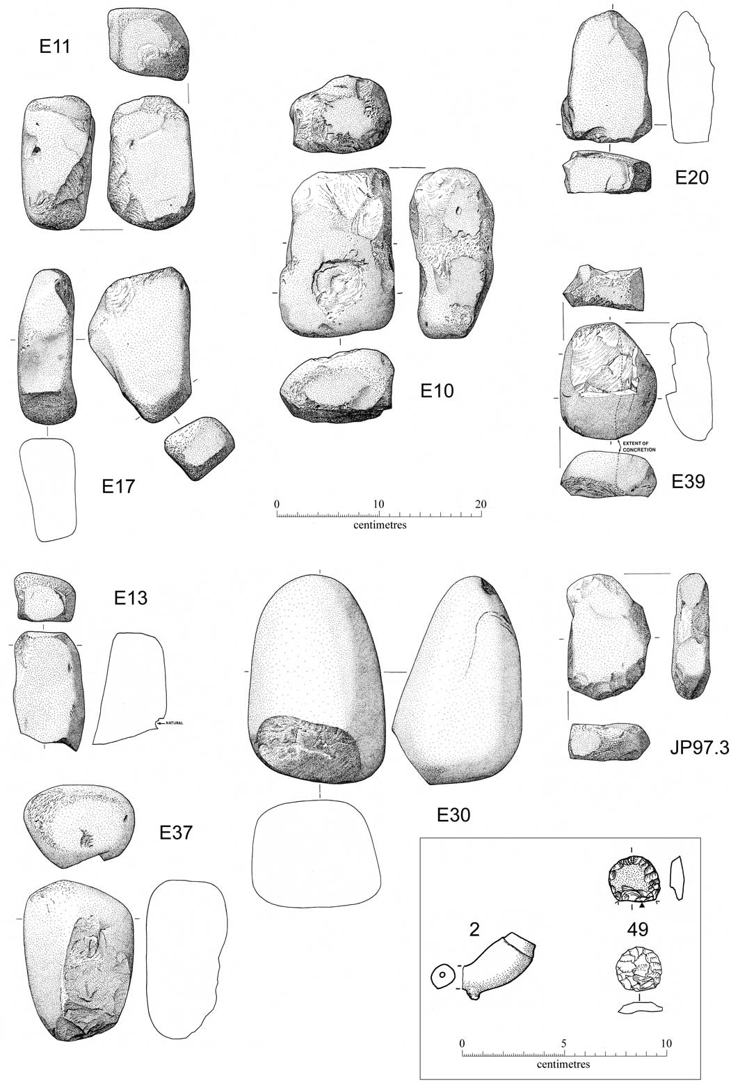
Stone tools: end/edge crushing stones (Type C2) and miscellaneous (bc); flint thumbnail scrapers (John Pickin); 17th century clay pipe from Stone Quarry Mine (David Higgins)

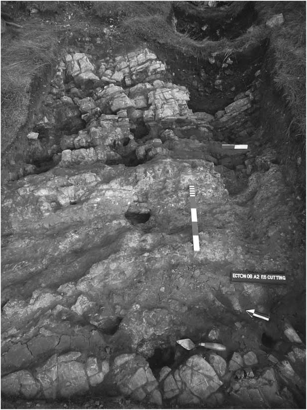
Trench A2 targeted the western end of 19 m long north-west–south-east to south-west–north-east curvilinear gully shown on survey as linking up with the underground gallery F.17 in Trench A1, indicating this to be a probable opencut, if not a drainage adit from this working. This was subsequently confirmed by excavation at the point where the floor of this 1 m+ wide ‘V’ to ‘U’-shaped cutting (F.6) intersected the slope of the hill and petered out into a shallow rock-cut channel clearly designed for the carriage of water (this represents a fall of about 3 m from the floor of the former mine gallery). However, the date of this remains uncertain. Fragments of a broken early–mid-18th century porcelain mug (ident. L. Mepham) recovered from a recut channel (046) in the top of the fill of this cutting does not appear to date this feature, but rather the draining and unblocking of the stope/inclined shaft upslope, the latter probably taking place during the re-investigation of the site during the 18th and 19th centuries. In Trench A2 the rock outcrop lay just below the surface. On removal of the turf an interesting group of small hammered and picked-out hollows was revealed, interpreted here as being early prospection features (Fig. 7). These pickings covered much of the deturfed rock outcrop, yet they seemed to be following only the most barely mineralised vughs and pods of calcite (F.8–F.14). This strategy of prospection was considered to be prehistoric, though it would prove impossible to date.
Stone Quarry excavation (Trench A2): early prospection features on the rock outcrop (ST)

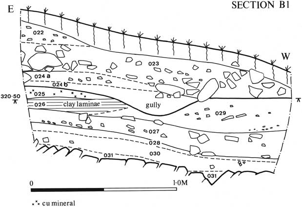
On the north side of the opencast, in Trench B1 (Fig. 8), the presence of further 17th century mine spoil was identified on the basis of finds of coal and a dated clay pipe fragment. This tip material formed the uppermost 0.25 m of a 0.9 m deep section. Beneath it lay an interesting sequence of thin interbedded soils and washed-out mineral layers suggesting repeated phases of mining activity followed by erosion. An upper humic horizon (024) overlay layers of weathered copper-rich mine spoil, (025) & (029) containing fragments of both charcoal and coal, and beneath this a 0.15–0.25 m thick layer of laminated humic clay (026) and peaty soil (027) representing a period of inactivity. Meanwhile, at the very base of the mining sequence, lay a thin lens of weathered mine spoil (028), which was thought might be the evidence for prehistoric working. This layer contained charcoal (but not coal) as well as many crushed mineralised fragments of malachite, calcite, and goethite. Nevertheless, despite 100% sampling, no hammerstone or bone tool fragments were recovered from it. The generalised interpretation of these mineral layers as the washed-out residues from mineral processing that took place in an area to the east of the opencast and around the area where the 18th century drawing shaft was eventually sunk, is supported by the findings from Trench B2. This small excavation, 4 m downslope to the north, contained a sterile stratigraphy of hillwash deposits, apart from one early and very tentative prehistoric mineral horizon (021), and does not support the idea that this was once an area of spoil tipping.
North facing section of Trench B1, to north of Stone Quarry shafts (bc)

The Lumb (2008)
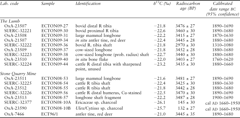
Trench C1 was on a 25° slope, 15 m to the west of the quarry (Fig. 9). Excavation here revealed a complex stratigraphy (Fig. 10) made up of hillwash deposits (104) intermixed with 19th century limekiln debris comprising calcined limestone and coal (103), and a scree. This comprised natural and quarried limestone blocks (105) infilling hollows present in an earlier landscape of shallow grassed-over hillocks of mine spoil and small working platforms, situated on the outcrop of a lead vein, one of at least three small north-west–south-east trending veins worked by means of shallow shafts on the slopes just south of The Lumb crest. At the top end of the trench the base of the scree (105) rested directly on a thin discontinuous clay layer (117) overlying the lowest sterile hillwash. The presence of crushed mine spoil including malachite within this clay suggests that this deposit was unrelated to local lead working, evidence for which was present in the trench. It was considered to be linked to what may have been the earliest mining activity on the hill, for example the prehistoric mining or processing of ores which might have been taking place at Mine No. 3, the tip of which lay only 7 m upslope of this point. Downslope, a thin lens of crushed lead mine spoil (108) marked the beginning of a denuded spoil tip. Above this horizon lay a stamped clay working floor (106) on which was found a fragment of an iron knife. This floor formed a platform or path between the workings sealing 0.4–0.5 m of mine tip composed of lenses of gravel-size crushings and burnt mine rock mixed with veinstuff, clay, and abundant coal and charcoal: (107) & (108a–b). This was clear indication of the practice of firesetting using both coal and wood as a fuel. At the bottom end of the slope this spoil sequence overlay another; a 0.3 m thick tip line consisting of charcoal-rich silt (109), 0.3 m of coarse broken mine rock mixed with clay, unabraded charcoal fragments, calcite, and galena (110), and, at the very base, a charcoal and coal-rich layer resting on natural shale scree. Upslope, a layer of mineral-rich silt (116) underlying the upper lead mine spoil (108) could be coeval with this earlier tip phase. The two phases of tipping have been dated from charcoal samples, suggesting lead mining on this vein sometime during the 12th–13th and again in the 15th–16th centuries ad (Table 2).
RADIOCARBON RESULTS IN THE PREHISTORIC MINEWORKING SERIES

Each sample consisted of a single fragment of a bone or antler apparently used as a prehistoric mining tool, other than ECTON08-10A and B, which were single charcoal fragments of different species.
The Lumb (2009)
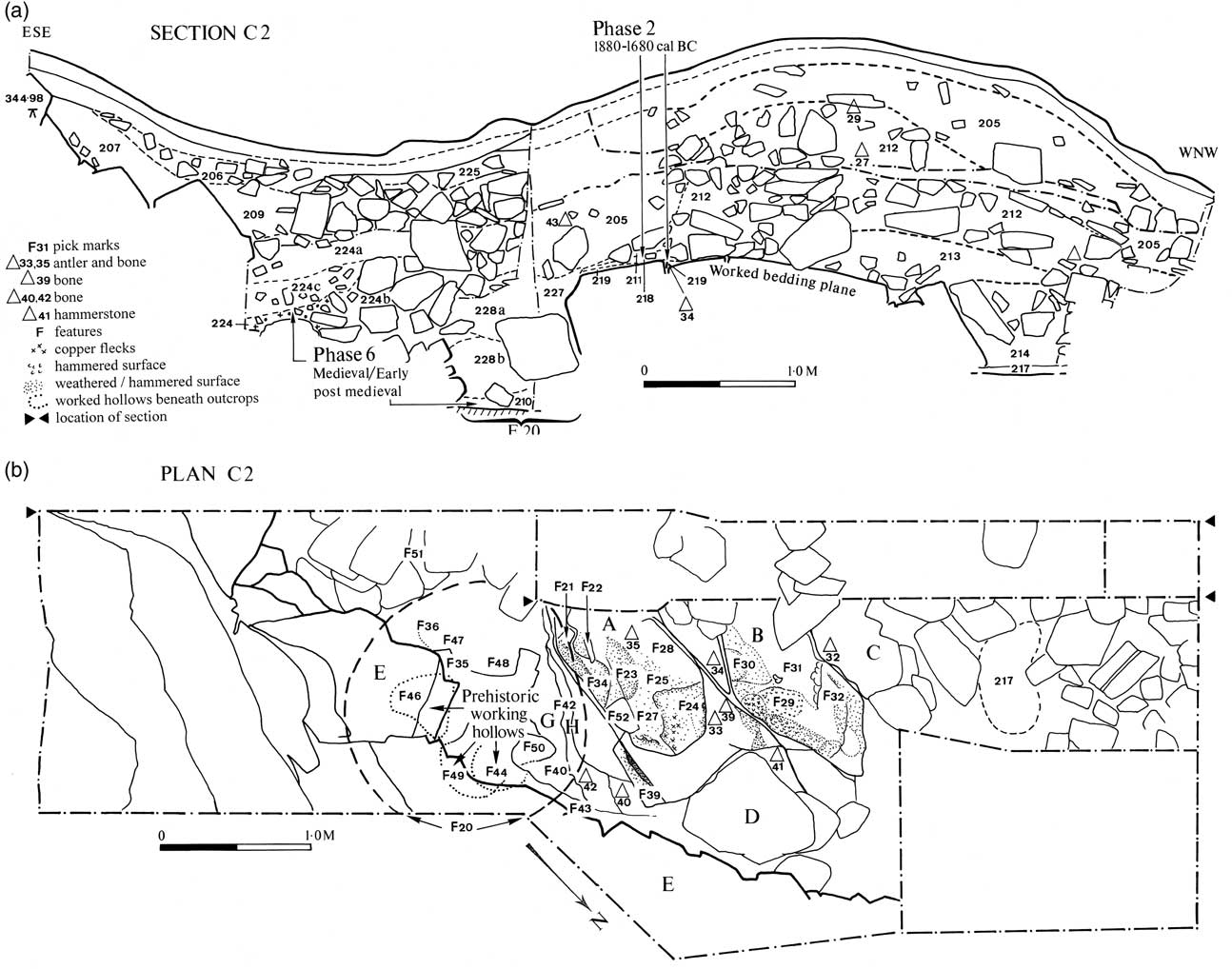
The investigation of Mine No. 1 workings on the north side of Entrance A began with the digging of a 1 m wide evaluation trench across the grassed-over mound which appeared to be the upcast from a 5 m wide hollow, possibly a re-excavation of a pre-existing working at the base of this cliff (Fig. 9). This mine was one of several small opencut workings which followed the 50 m long outcrop of this mineralised bed across the west-facing scarp slope of the hill, immediately above which lay a series of low cave-like openings (Fig. 12). The excavation of the Mine 1 tip revealed 1–1.8 m of rock spoil covering an irregular boulder-strewn outcrop which showed signs of having been worked but also, in some places, of intense weathering. The most striking feature of the section through this upcast spoil (Fig. 11a, right) was the distinctive upper layer of reddish–brown clay (205) which may have been redeposited during the medieval or post-medieval periods from an underground working located upslope of this, which extended across the hollow, and merged with a more recently formed natural clay-filled scree (206) at the cliff face. The spoil layers beneath this were quite different, consisting of a jumble of large angular (212) and smaller rocks (213) with traces of ore minerals in an earthy matrix. All of these contained redeposited bone or stone mining tools, though the interpretation of how these ended up here was more complex, relating to the re-excavation during the course of prospection of this earlier-mined feature. An investigation of this hollow revealed it to be a >4 m long, boulder-filled opencut 2 m wide at the top, and 0.7–1 m wide at its base, and 1–1.5 m deep (at its southern end). Apart from its original working, there appear to have been at least two subsequent phases of disturbance. The earlier phase of prospection or mining work is suggested by an area of disturbance close to the western edge of the opencut. Here redeposited prehistoric (211), and possibly later, mine spoil (210) rich in mineral appears to be mixed with the disturbed natural clay and rock infill of the opencut (227), and unweathered intrusive boulders of rock (228; Fig. 11a, right). This disturbance remains undated, but the presence of a metal pick hole in a slaty fragment of limestone suggests historic, possibly medieval–early post-medieval mining. A subsequent and more obvious disturbance could be seen in the form of an irregular-shaped 1.5 m wide prospection pit (F.20) cut from the top of clay infill (206) in the centre of the hollow down to the floor of the opencut (see Fig. 11). In section it could be seen that this pit had been backfilled with layers of loose rock and clay with washed-out charcoal and coal in its base; material which seems to have come from another working just to the south, and which was most likely associated with medieval or later firesetting (cf. Barnatt & Worthington Reference Barnatt and Worthington2006). This forms the bottom of the spoil tip, whilst the clay forming the uppermost layer (205) has been tipped from the neighbouring opencast (or perhaps even from the clearance of the adjacent underground working (Mine Entrance A)). The bone tools, therefore, came from both these sites.
a. North-facing section through The Lumb Trench C2 (Mine No. 1): section through mine tip & across infill of feature shows position of hammerstone & bone finds; b. plan of floor of opencut and its NW edge shows prehistoric mining (worked hollows), position of tool finds & tooling features. Circular feature (F.20) is later prospection pit (bc & ST)

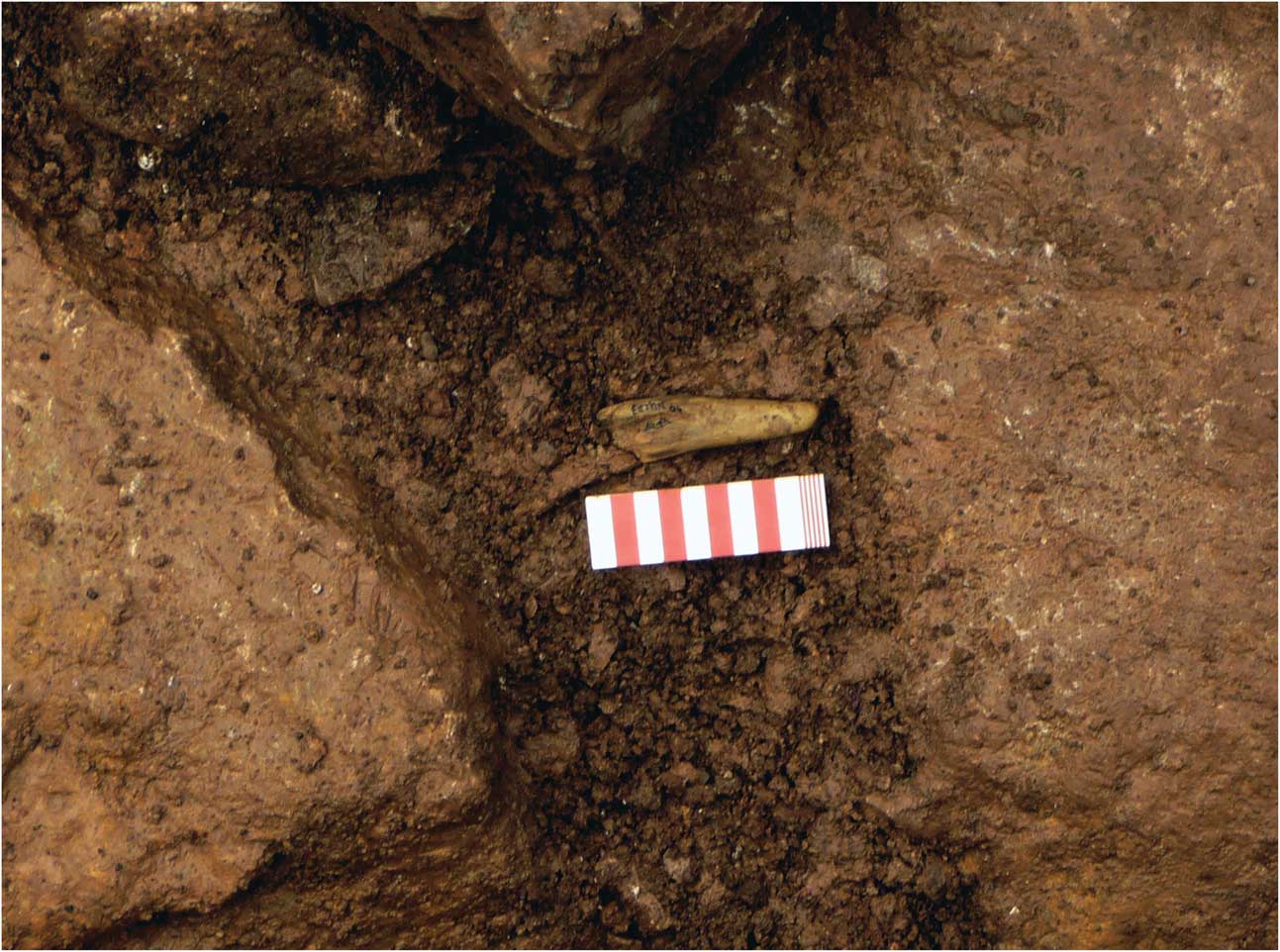
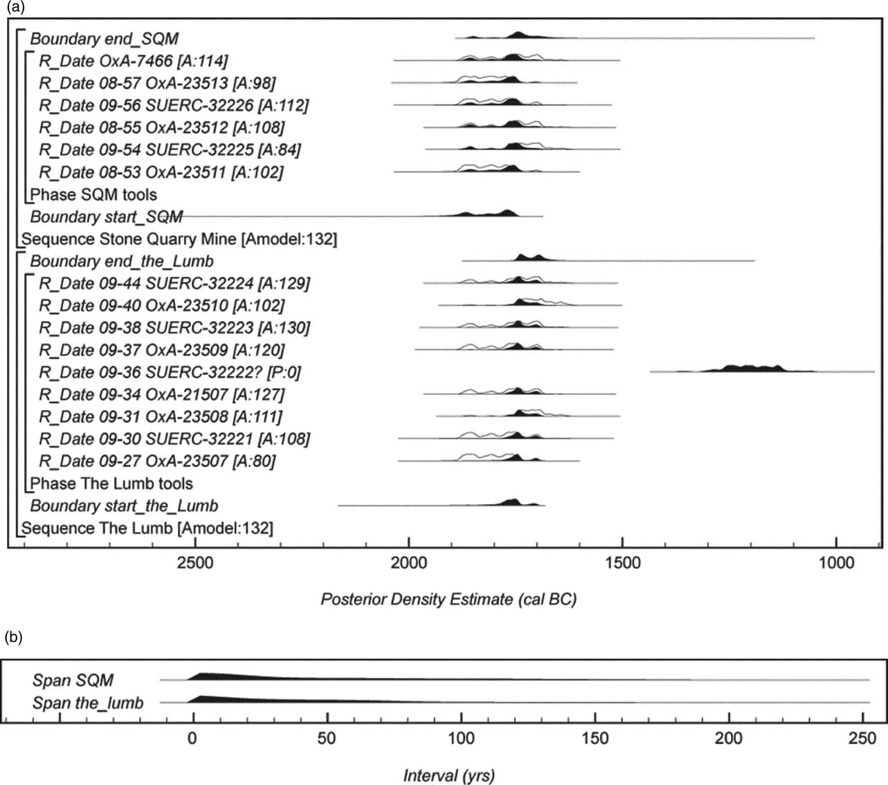
The mineralised and partly-worked bedding plane slabs of dolomitised limestone (Fig. 11b, A–C) buried beneath the clearance tip, appear to have been examined by the later miners, but otherwise remain untouched. A triple pick mark made with an iron tool was found on the highest point of the bedrock slab B, and there were a number of other modern-looking fractures nearby. More difficult to explain was the absence of prehistoric mine spoil or other deposits; it was not clear what had been removed by the later miners and what were just the effects of ancient erosion upon this previously exposed outcrop. In fact, the main, but small, survival of original mine sediment was that lying on a small area of bedrock slab on the side of the opencut (A), in particular within a natural fissure immediately just to the north. Here a thin layer of clay (227) and a reddish charcoal-rich silt (211) sealed less than 50 mm depth of undisturbed silty mine sediment (218), the latter containing mineral fragments (dolomite, calcite, galena, and malachite) and disseminated charcoal in an area no bigger than 0.64 m2. This layer also contained fragments of bone and antler and a single hammerstone <SF 41> recovered from a lower bedrock ledge to the east. Within the slightly deeper stratigraphy of the fissure between two bedrock slabs, two parts of a clearly in situ worked antler point <SF 34> were recovered from a similar mineral-rich sediment (Fig. 13). Radiocarbon dated to 1880–1680 cal bc (OxA-21507), this proved to be one of the most important finds from the excavation.
Antler find in situ, Trench C2 (ST)

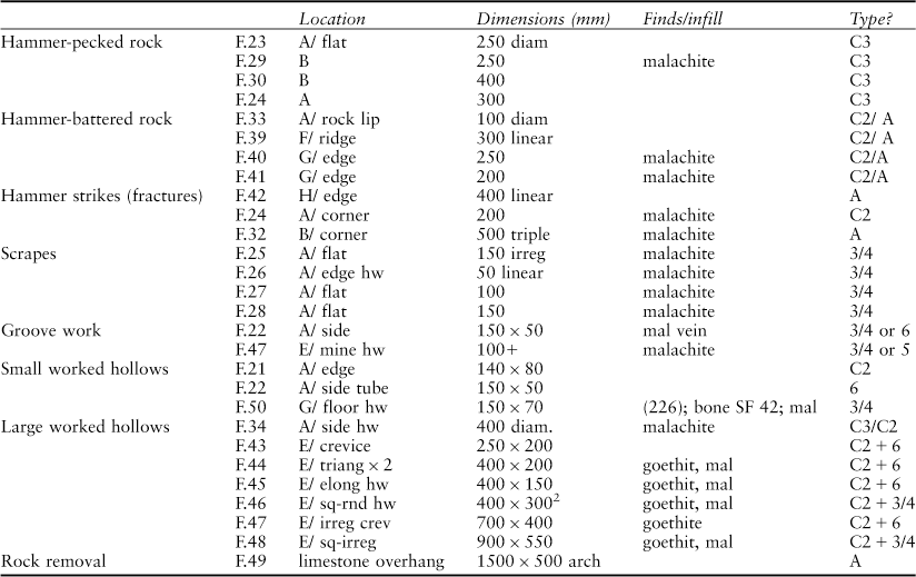
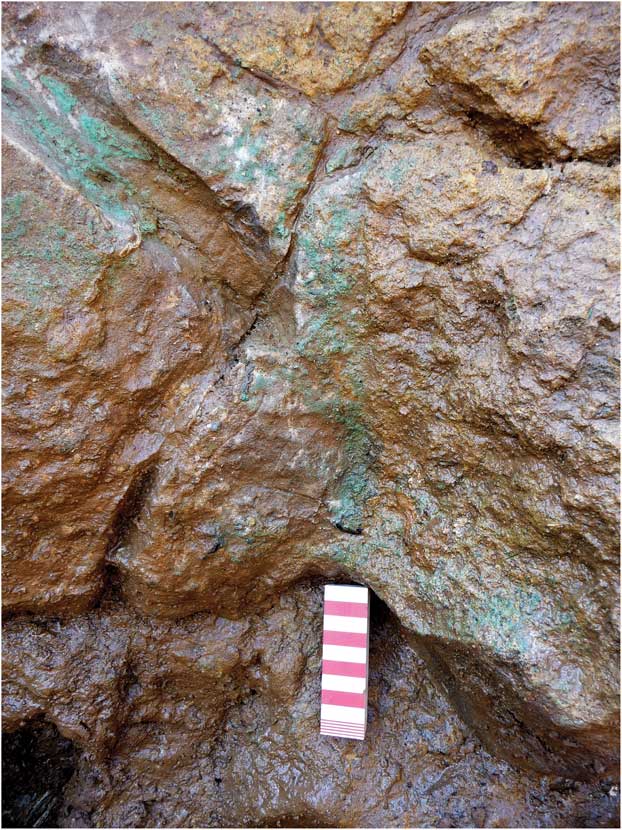
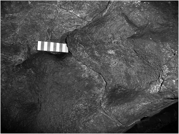
After cleaning the surface of the bedrock slabs, 18 tooling marks or mining-associated fractures relating to probable prehistoric working were identified (Table 1). This included 11 examples for the use of hand-held stone hammers on the harder limestone beds (in particular the footwall of the deposit), and four examples of the scraping of thin malachite films from mineral-coated fractures and from weathered surfaces of rock (Fig. 14). Some of these tooling features are referred to as ‘antler scrapes’ but just as likely this ‘soft work’ would have been done with bone chisels or scrapers, the evidence for which are the numerous small splinters of bone recovered from the mining sediments. One of these <SF 42> was found within a yellow–brown silty sand (226) infilling a 0.15 m deep hollow dug into the dolomitised floor bed (G) on a ledge on the side of the opencast. Within this area there was little original mining sediment apart from a thin discontinuous layer of silt (211) and clay (227), some of which could have been washed-in. Beyond this point, the base of the opencut below the prospection shaft been completely cleared out, although a series of prehistoric mining hollows present in the working face of this mineralised bed along the eastern wall had survived, empty but untouched (E).
CATALOGUE OF PREHISTORIC MINING FEATURES, TOOL MARKS & WORKING TECHNIQUES IDENTIFIED WITHIN THE LUMB MINE NO. 1 OPENCUT (TRENCH C2)

KEY: G/edge = outcrop G (see Fig. 9a) + working along edge; E sq-rnd hw = outcrop E + square to round shaped worked hollow; E/ sq-irreg = E + square-irregular shaped hollow; E/ irreg crev = E + irregular shaped crevice; E/triang = E + triangular-shaped hollow; 400 linear = 400 mm long tooling mark; SF 42 = bone find; Type C3 = possible type of stone tool used; Type 3/4 = possible type of bone tool used; goethit = goethite (iron oxide); mal = malachite.
Malachite scrape working, Trench C2 (ST)

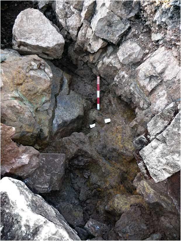
Mined hollows and opencast, Trench C2 (ST)


The working of small hollows to extract malachite from the most copper-rich 0.5 m section of this 1 m thick bed of mineralised dolomitic limestone appears to have resulted in the creation of much larger cavities (eg F.46; Figs 11b & 15). The largest of these surviving round-square or elongate hollows was up to 0.5 m wide and high, and formed parallel or en echelon workings with those in the beds beneath (F.48). The action of undercutting and, as a result, the intentional or unintentional collapse of the overlying harder roof beds, may have been the method of working these lateral opencuts. In some places an attempt had been made at providing a more stable roof in the overlying limestone, hammering this back to form a concavity or arch (F.49). The evidence in the trench is of moderately systematic working. Seven main hollows have been identified. These appear to have been hammered, but perhaps also picked out of the now soft weathered dolomite using bone tools, although it is difficult now to determine how much of the rounded shape of these hollows is due to subsequent weathering. The impression obtained from the excavation of the interior of this opencut is that abandoned working was left exposed to the elements rather than being backfilled. One or two of the large rocks appear to have collapsed or become detached from the outcrop during mining and had been left in situ (eg, boulder D which rests directly upon a thin prehistoric mine sediment), although most of the large boulders fell in afterwards, presumably following the abandonment of the working and the exposure of the rock to weathering and subsequent instability.
Site phasing
The phasing of individual excavation cuts have been amalgamated to provide a more coherent picture of the relative periods of mining and abandonment at these two sites. Apart from the radiocarbon stratigraphy of the prehistoric and medieval workings on The Lumb, there are few chronological markers available for the periods of activity identified.
SPECIALIST REPORTS
Bone mining tools (Brenda Craddock, Simon Timberlake, & Vida Rajkovača)
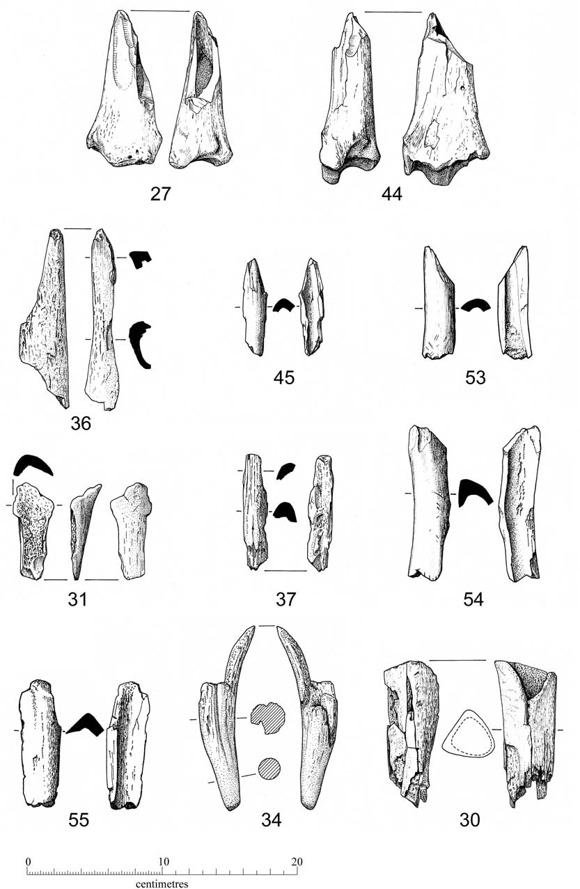
Two seasons of excavations at Ecton have resulted in the recovery of a combined total of 25 bone fragments, of which 11 could be assigned to species level. This includes worked antler and bone; most of the latter being cattle long bone shafts fashioned into gouges or bone points (Fig. 16). Despite the dominance of cattle, at least two of the bones recovered from the Early Bronze Age mining horizon at The Lumb (Trench C2) are from sheep-size animals.
Bone tools (Stone Quarry & The Lumb) (bc)

The overall poor preservation of the assemblage means that it was not possible to measure or age any of the elements recorded in the dataset. For those elements which show clear signs of butchery, the actions seem to have been crude and performed with the use of large blades. Bone shafts may well have been initially split for marrow extraction and then used as tools.
Nearly all the tools recovered were found redeposited in post-medieval mine spoil associated with the Stone Quarry and Lumb workings; the exceptions being the antler point (<SF34>) and associated bone fragment (<SF40>) which were discovered in situ within prehistoric mine sediments on The Lumb. Twelve utilised bones and the antler point have now been radiocarbon dated.
The 15 identified bone tools are very fragmentary, making it difficult to categorise them with any certainty. Most are utilised cow-sized limb bones, but we do not have a large enough sample of recognisable pieces to suggest any preference for right or left. More than half of these are stained green with copper.
Broadly six types (including three main types 1–3) have been recognised, based on form and possible function (Fig. 16). Occasionally a single tool (e.g. Fig. 16, 53) may have had two functional uses. The same types of tool appear to have been in use at both sites.
Type 1: Heavy cattle-size tibia, distal end; naturally rounded joint end forms handle; facetted point has obliquely cut into interior bone hollow making pointed tool that also functions as a scoop (2 examples: Fig. 16, 27 & 44). No signs of ever having being hammered with another tool, therefore probably not used as chisels.
Type 2: Points, chisels, or scrapers made from axially split limb bones (Fig. 16, 36, 45, 53).
Type 3: Scoops usually made from axially split limb bones cut to make a ‘chisel’ end (Fig. 16, 37, 53–5; & 38 (not illus)).
Type 4: Scoop (Fig. 16, 31); ‘chisel’ end opposed by broad scoop formed by natural splayed flake of articular end of limb bone.
Type 5: Long bone shaft; hollow triangular section cut (or worn) obliquely at an angle (Fig. 16, 30).
Type 6: Red deer antler tine point (Fig. 16, 3); probably end of a pick from The Lumb Trench C2, context 219.
In addition there are a few fragments of bone recovered from Stone Quarry (Trench A1) which could have been used as tools, but could not be properly categorised (<SF56>, cow right humerus & <SF57>, cow-sized limb bone frag.).
Of these, the multiple tool <SF53>, two of the scoops, and the two possible tool fragments (<SFs 56–7) came from Stone Quarry Mine, with two Type 1, two Type 2, three Type 3 and the Type 5 and Type 6 tools coming from The Lumb. Of the two conjoining fragments of antler tine (< SF34 >; Figs 13 & 16), only the tip of the point shows any signs of wear, and this appears to have been blunted flat during use. It is impossible now to say whether the proximal end was modified or adapted for purposes of hafting in a handle (as is thought to have been the case with the antler from Dutchman Mine which had been chamfered at the blunt end for such a purpose; Barnatt & Thomas Reference Barnatt and Thomas1998). However <SF34> has two scored lines (or grooves) which appear have been cut close together along one side of the smoothed tine. It is possible they indicate groove and splinter technique for the extraction and manufacture of an antler needle, probably using a flint burin (W. Lord pers. comm.). The importance for mining of the working end of the antler does not really support this idea, yet it is possible that the splitting was unsuccessful and the point then used as a pick, or vice versa (VR). It is also feasible that the grooves could have been part of an adaption designed for securing the point within a wooden pick.
All these tools (particularly the scoops or ‘chisel end’ points) could have been used for scraping-off the thin filmy malachite deposits or for digging malachite out from pockets of the soft ochreous mud and/or rotted dolomite. Scrape marks, possibly some of those made by these tools, have been identified on malachite-stained bedding plane surfaces in Trench C2 on The Lumb.
Stone mining tools (Brenda Craddock & Simon Timberlake)
This study includes all of the tools collected during the course of the current field survey and excavation project. Seventeen tools were found during fieldwalking in 2008 (see Fig. 1), another ten were recovered from excavations at Stone Quarry Mine (Trench A1), and a further five from excavations carried out on The Lumb (Trench C2). In addition, a large quartzite cobble was found by Roger Doonan during preliminary investigations of a postulated processing site above The Lumb in September 2008.
To this sample can be added another four cobbles found by John Pickin during fieldwalking below the top of the Ecton Pipe workings, Stone Quarry, and The Lumb in 1997 (now in the Peak District Mining Museum, Matlock Bath), referred to below by the prefix JP97. This makes, in total, 37 cobbles with a confirmed tool use. A further 15 cobbles collected during the walk-over survey seem never to have been used as hammerstones, though all were of the right size and material. This leaves the possibility that they had been gathered, but not used, by the Bronze Age miners.
Amongst the cobbles were seven spalls (or flakes) broken off larger tools, of which only two (E31 & E40) had been re-used. The majority of the tools examined appear to have been used for some form of ore preparation rather than for primary extraction of rock and ore.
The typological classification used in this report was first developed by Jenkins and Timberlake (Reference Jenkins and Timberlake1997), adapted in Timberlake (Reference Timberlake2003), then amended by Timberlake and Craddock (Reference Timberlake and Craddock2013). The cobbles have been numbered E1–E44, as entered into the Ecton excavation archive (SQ=Stone Quarry; TL= The Lumb; WS= walk-over survey (EMRG Hammer nos E10–E20 and JB's collection E1–E9 & E21–E28). The distribution of the cobbles are shown on the map in Figure 1. Morphometric measurements have been undertaken using the latest version of the Standard Hammer Stone Recording Sheet (Timberlake & Craddock Reference Timberlake and Craddock2013). The following categories of tool have been identified (some examples are considered to have had multiple functions).
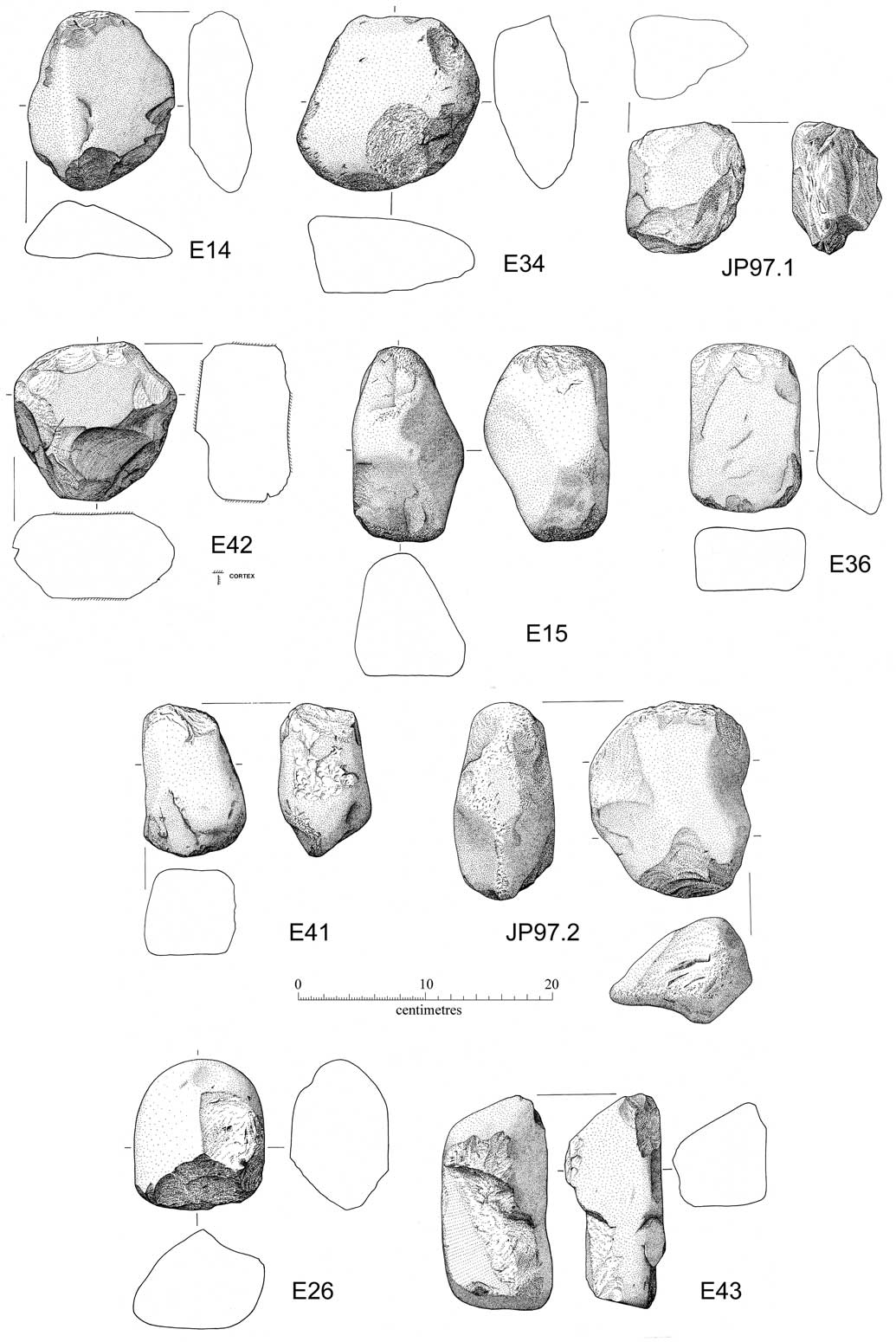
a. Disc hammers/crushers (Type C3) (Fig. 17: E14, E34, E42, JP97 no. 1).
Stone tools: discoid crushing stones (Type C3), heavy crushing stones (Type C5), mining hammers (Type A/AA) (bc)

Heavy hand-held tools, most >1 kg (range 0.91–>1.5 kg) in weight; broken (flaked) around sides for two-thirds or more of perimeter as a result of crushing use. Probably used to break up some of the mined ore-bearing rock.
b. End/edge crushing stones (local variant Type C2) (Fig. 19: E10, E11, E13, E17, E20, E37, E39, JP97 no. 3).
These show a pattern of end-use that has left an ‘island’ of undamaged surface (cortex) in spite of heavy use. At first sight appears to be heavy hammering wear observed elsewhere to be result of mining tool use against a rock face. However, given these ‘islands’ of undamaged cortex survive, it seems highly doubtful that, even if hand-held, such precision could have been achieved using these as hammers, less likely still if the cobbles were hafted and swung. Probably used as heavy hand tools for pounding and breaking up the ore-bearing rock. Weight 0.69–>2 kg.
Hammerstone E10 (WS no.1) is unusual and interesting. While this looks like a mining hammer, with a partial groove pecked-out around the middle for hafting, the heavy pounding wear and flaking damage are only along the edges of each end, leaving an island of cortex remaining. This suggests that the cobble was mainly used as a hand-held crushing implement. In fact the hafting groove may well have been a later modification undertaken with the intention of then using this as a hammer. Subsequently a flake removed the groove from the left-hand side and rendered this modification useless; as a result this cobble may have been discarded shortly afterwards. What appears to be an area of ‘anvil’ use in the centre of the face shown in the left-hand view is actually a hollow resulting from the flaking (delamination) of the stone. Since there is no evidence of compaction, it appears that something else, such as the end of an iron pick, may have been responsible. Along with other cobble stones this was found redeposited within an 18th–19th century tip below the Dutchman Adit. It thus seems possible that this tool was ‘dug out’ by post-medieval miners as they were clearing and re-mining ancient backfilled workings above adit level in the base of the Stone Quarry ‘pipe’, or in ancient workings further to the south-east that were intersected when Goodhope Level was driven from just within Dutchman Level in the 1850s, and that the damage to it dates from this period. This is significant as the only ‘grooved’ hammerstone recorded from the Ecton Mines.
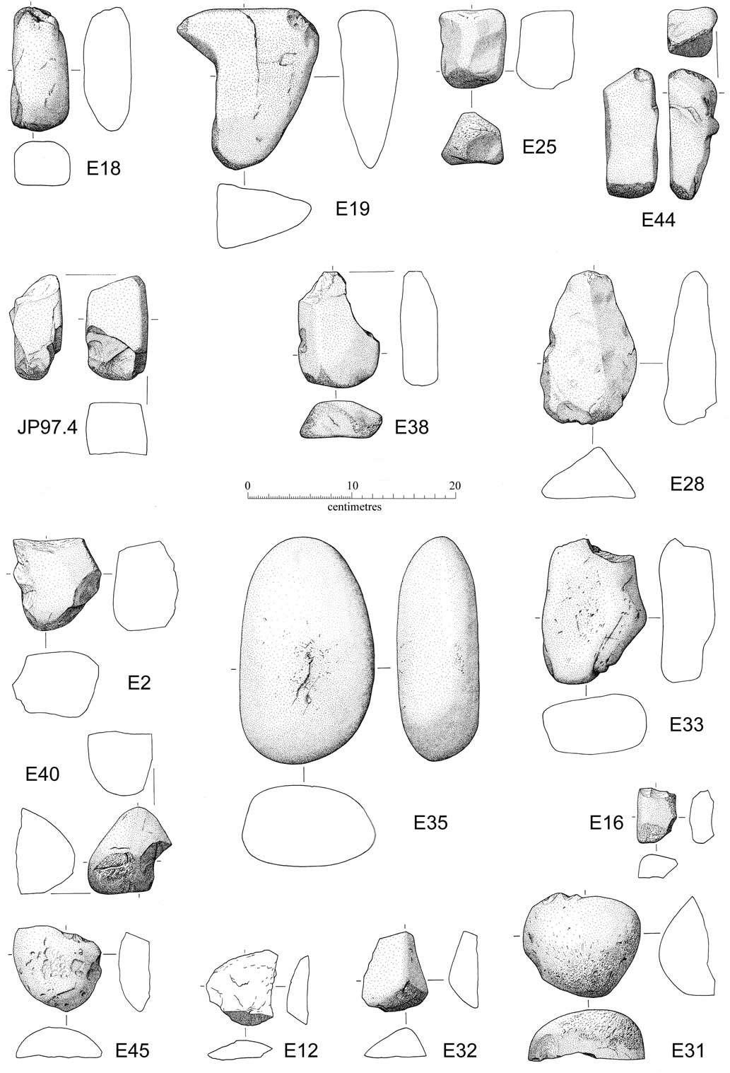
c. Pestles or light grinding/crushing stones (Type C4) (Fig. 18: E18, E19, E25, E28, E38, E44, JP97 no. 4).
Stone tools: pestles and light grinding/crushing stones (Type C4), mortar/anvil stones (Type E), and spalls (flakes) (bc)

Mostly small, long, narrow (60–80 mm) river pebbles with mean weight of c. 0.5 kg (0.43–1.23 kg); used on their ends like pestles for fine grinding of small particles of ore mineral.
d. Heavy crushing stones (Type C5) ( Fig. 17: E15, E36, E41, JP97 no. 2).
These show evidence for heavier pounding use on both ends. Most likely used for ore crushing or for breaking-up of mined rock. However, could also have been used as hand-held or hafted mining hammers. Typical weight 1 kg+.
e. Mining hammers (Type A and Type AA) ( Figs 17 & 19: E10, E11, E15, E20, E26, E37, E39, E43).
Believed to have been used for primary rock removal and breaking. May have been hand-held, hafted with modification, or where of suitable shape, hafted without modification. Most functioned as crushing implements (weight >1 kg).
f. Spalls (detached flakes) (Fig. 18: E2, E12, E16, E31, E32, E40, E45).
Fragments broken off larger cobble tools during use. Occasionally re-used.
g. Mortar/anvil stones (Type E) ( Figs 17 & 18: E33, E35, E41).
Stones upon which ore mineral was crushed (weight 0.97–3.53 kg). There are very few from Ecton, which begs the question as to where the final crushing and grinding took place.
h. Miscellaneous (Fig. 19: E30)
One stone which has not been assigned to any category, nor can it be considered unused. It is the largest cobble (4.88 kg) collected on Ecton Hill (just above The Lumb), though it shows little evidence of use. Possibly a large hammerstone. The extreme hardness of this metaquartzite rock may account for the lack of significant bruising, though the narrow end is broken off.
Of the 29 cobble stone implements analysed in detail most appear to have been used for ore preparation. These range from the heavy disc crushing stones used for rough cobbing to small pestles for fine grinding. Most of the tools only have one type of use, although 35% show signs of multiple functions or re-use. For example, cobble E10 has had at least two uses, whilst five other crushing stones have also been used as hammers. There are only three cobbles which appear to have been used as anvil or mortar stones. At least one of these (E41) could have been a mallet rather than an anvil. The other two are a little more convincing; E35 has traces of copper staining within the area of fissuring on the bruised upper surface and E33 has traces of bruising on its naturally concave surface. So where and how was this material being crushed? One possibility is that the crushing of the soft filmy carbonate left little impression on the stones. Another possibility is that the unique pestle tools here were used to finely pulverize the ore in situ, or else within cracks or hollows in the underlying bedrock. Only eight cobbles had clearly been used as hammers for primary rock removal and for the fracturing of the mined rock face. At least six of these had also been used for ore preparation. While the number of mining hammers (Type A/AA) found here seems small compared to those found at other British Bronze Age mines (such as Cwmystwyth, Parys Mountain, and Alderley Edge; Timberlake & Craddock Reference Timberlake and Craddock2013) we should bear in mind that the near-surface rock here could, perhaps, have been prised off with just antler picks and wooden levers.
The geological origin of the two main types of cobble utilised as mining tools is interesting, since both the lithologies present can be identified, as can the possible collection areas of cobbles. More or less the complete range of rounded-rectangular shaped brown–black patinated river cobbles of local quartzitic-sandstone, gritstone, sandstone, and siltstone can still be collected today from the river bed and flood plain of the River Manifold between Hulme End and Ecton. Together these rocks make up more than 75% of the stone tools found on Ecton Hill. Most of the cobbles have been eroded out of individual sandstone and proto-quartzite sandstone units (such as The Minn, Hardlow, Lum Edge, and Longnor Sandstones) present within the Upper Carboniferous Edale Shale Group, the outcrops of which have been cut by the incised course of the river less than 2 km upstream of the mine (Ford Reference Ford2000, 2 & 6). The metaquartzite cobbles, on the other hand, may have been collected a little further afield. These are glacial erratics which may have been deposited within Neogene sand pockets found infilling solution features and weathered horizons in the top of the Carboniferous Limestone. The nearest significant sand pocket and source of erratics to Ecton lies a few kilometres to the north and west of Hulme End (see Fig. 1b), although another source might be from glacially deposited mounds of stones such as that found at Brock Low (Barnatt pers. comm.) As there is no evidence that any of these ended up as river cobbles in the River Manifold, the most likely explanation is that they were collected at source from the weathered surface of the limestone. Although a good deal harder and tougher than the proto-quartzites, it appears that some of these used metaquartzite cobbles have suffered brittle fracture along lines of weakness and joints.
In 2009 a simple experiment was undertaken using one of these cobbles. A fairly typical rectangular proto-quartzite cobble weighing 1–1.5 kg was collected from the bed of the River Manifold below Ecton Hill, and used as a hand-held hammer to extract mineral from the recently excavated Bronze Age mining horizon on The Lumb. This was found to be effective at working a hollow into the dolomite, the bruising on both the bedrock and hammer surfaces being quite similar to that seen prehistoric examples.
Worked flint (John Pickin)
An Early Bronze Age thumbnail scraper was found during excavations at The Lumb in 2009. This was found just beneath the turf at the bottom north-west corner of Trench C2 during topsoil stripping. The scraper (W: 22 mm; L: 21 mm; T: 6 mm) is on a corticated flake, the exposed surface having a white patina. Two sides and the proximal end have steep-angled retouch. The bulbar end is unworked and has a pronounced striking platform (Fig. 19, 49).
In 1983 a thumbnail scraper was found by Richard Carr whilst walking on The Lumb. Its approximate findspot [SK 097579] lies about 200 m to the south-west of the 2009 excavation site. The scraper is of similar size and type, being made on a sub-circular flake of uncorticated dark grey flint (diam: 21 mm), with evidence for invasive retouch across the whole dorsal surface (Fig 19, bottom right).
Radiocarbon dating – prehistoric mining (John Meadows, Christopher Bronk Ramsey, Gordon Cook, Simon Timberlake, & Peter Marshall)
Fourteen bone and antler samples were dated to establish the date range of the probable prehistoric mining phase(s) and determine whether these two sites are part of the same phase of activity. This was in addition to a single date obtained in the late 1990s from an antler tool found at 11.5 m below surface at Stone Quarry Mine (Barnatt & Thomas Reference Barnatt and Thomas1998). The radiocarbon results confirm the preliminary identification of these samples as Bronze Age tools. Two charcoal samples, which appeared to have burnt in situ at the Stone Quarry Mine site, were dated to the post-medieval period.
Sample Selection
Only short-lived, single-entity samples were considered for dating. Datable materials meeting these criteria included antler and animal bone implements interpreted as mineworking tools, whose dates are directly relevant to the chronology of mining at the two locations. Twelve such implements with clear traces of use-wear were selected (six from The Lumb and five from Stone Quarry Mine), as well as one implement, from The Lumb (ECTON08-44), which was a prepared but unused bone tool (almost identical in form to ECTON09-27, also from The Lumb, which was clearly used).
All but one of these implements was apparently redeposited by post-medieval mineworking. The exception was antler point <SF34>, found within (219), a pocket of early mining sediment preserved within a crack between two outcrops of worked bedrock at The Lumb. The undisturbed early mining layer was recognisable on account of the presence of splinters of bone and antler associated with some of the larger tool fragments, suggesting that these tools had been used nearby. One of the larger bone splinters was also selected for dating (ECTON09-40). The top of the early mining sediment was slightly weathered, to a thin humic clayey soil (211), sealed by a thin layer of red clay (227), which in turn was sealed by redeposited mine spoil associated with the later mineworking. The recovery of two pieces of the antler point, which lay as fractured (probably in antiquity), supports the interpretation that the early mining layer was undisturbed, despite the proximity of later dumping.
At Stone Quarry Mine, a charcoal-rich deposit (036) appeared to have been burnt in situ and it was not certain to which mineworking phase this belonged. Bulk charcoal from this deposit was sorted for fragments with insignificant intrinsic ages (specimens from short-lived tree taxon, or from short-lived material, such as twig, branch, or sapwood), and two suitable specimens of different species were identified.
MEASUREMENT AND RESULTS
The samples from the excavation were dated by Accelerator Mass Spectrometry (AMS) radiocarbon dating at the Oxford Radiocarbon Accelerator Unit at Oxford University (following the laboratory methods described by Brock et al. (Reference Brock, Higham, Ditchfield and Bronk Ramsey2010) and Bronk Ramsey et al. (Reference Bronk Ramsey, Higham and Leach2004)) or at the Scottish Universities Environmental Research Centre in East Kilbride (technical procedures are given by Vandeputte et al. (Reference Vandeputte, Moens and Dams1996); Slota et al. (Reference Slota, Jull, Linick and Toolin1987); and Xu et al. (Reference Xu, Anderson, Bryant, Cook, Dougans, Freeman, Naysmith, Schnabel and Scott2004)). The sample from Stone Quarry Mine dated in 1998 was processed according to methods outlined in Bronk Ramsey et al. (Reference Bronk Ramsey, Pettitt, Hedges, Hodgins and Owen2000) and measured using AMS (Bronk Ramsey & Hedges Reference Bronk Ramsey and Hedges1997). Internal quality assurance procedures at both laboratories and international inter-comparisons (Scott Reference Scott2003) indicate no laboratory offsets, and validate the measurement precision quoted.
The results (Table 2) are conventional radiocarbon ages (Stuiver & Polach Reference Stuiver and Polach1977), quoted according to the format defined by the Trondheim convention (Stuiver & Kra Reference Stuiver and Kra1986). The calibrations of these results, which relate the radiocarbon measurements directly to the calendrical time scale, are given in Table 2 and in outline in Figure 20a (the two post-medieval dates have been excluded). All have been calculated using the datasets published by Reimer et al. (Reference Reimer, Baillie, Bard, Bayliss, Beck, Blackwell, Bronk Ramsey, Buck, Burr, Edwards, Friedrich, Grootes, Guilderson, Hajdas, Heaton, Hogg, Hughen, Kaiser, Kromer, McCormac, Manning, Reimer, Remmele, Richards, Southon, Talamo, Taylor, Turney, Plicht and van der & Weyhenmeyer2009) and the computer program OxCal v4.1 (Bronk Ramsey Reference Bronk Ramsey1995; Reference Bronk Ramsey1998; Reference Bronk Ramsey2001; Reference Bronk Ramsey2009). The calibrated date ranges cited are quoted in the form recommended by Mook (Reference Mook1986), with the end points rounded outward to 10 years. The ranges in Table 2 have been calculated according to the maximum intercept method (Stuiver & Reimer Reference Stuiver and Reimer1986); the probability distributions shown in Figure 20a are derived from the probability method (Stuiver & Reimer Reference Stuiver and Reimer1993).
a. Bayesian model of prehistoric mineworking chronology, Ecton. Distributions in outline are probability distributions obtained by simple calibration of radiocarbon results. Solid distributions are posterior density estimates of dates of these samples, & of events associated with them. SUERC-32222 is omitted from the model, & distribution shown is that obtained by simple calibration. The model structure is exactly defined by the brackets & OxCal keywords on left-hand side of figure; b. duration of prehistoric mineworking activity at The Lumb & Stone Quarry Mine, derived from model shown in Fig. 20a (John Meadows & Peter Marshall)

The Stone Quarry Mine charcoals proved to be post-medieval in date, and therefore irrelevant to the chronology of prehistoric mineworking at this site (Table 2). All other samples were dated to the 2nd millennium cal bc, most clustering in the Early Bronze Age (Fig. 20a).
Figure 20a shows a simple Bayesian model of the prehistoric radiocarbon results. The Bayesian approach to chronological modelling (Buck et al. Reference Buck, Cavanagh and Litton1996) emphasises that the dates of individual radiocarbon samples are not necessarily of interest, whereas the archaeologist is usually interested in the dates of events associated with the dated samples. By combining all the available dating information, a model can give statistically robust estimates of the dates of interest, both of individual samples and of associated events. These are referred to as posterior density estimates, and by convention they are given in italics as they depend on all the dating information specified in the model, and would change if any of this information were altered.
With the prehistoric mineworking samples we are naturally concerned with the dates of the samples themselves, since each sample submitted was identified as a tool or tool fragment, but we can also use the Bayesian ‘bounded phase’ model (Bronk Ramsey Reference Bronk Ramsey2000) to interpret the spread of calibrated radiocarbon results. A bounded phase model incorporates the assumption that the results included in the model are representative of a single, continuous phase of activity, which has a beginning and an end date, for which the model calculates probability distributions, based on the spread of calibrated dates. If the phase of activity were longer than this, we would expect to find a greater scatter of radiocarbon results.
The model shown in Figure 20a assumes that, at each location, the tools found represent a single, continuous phase of activity, but that the relative dates of the samples, and of the sites, is unknown. The model also assumes that each dated bone belonged to a different animal, which can only be proven in a few cases (eg, where the same skeletal element has been dated more than once – it is clear that cattle tibiae were found to be particularly suitable for making mineworking tools). The only bone which is distinctly different in date to all the others is ECTON09-36, from The Lumb, which dates to the later part of the Middle Bronze Age and has therefore been excluded from the model (the probability that it dates to main phase of activity is 0%: SUERC-32222, P:0, Fig. 20a). Interestingly, this was also a bovid tibia shaft, and appears to indicate that there may have been a second phase of mineworking in this period, although so far only one sample of this date has been recovered.
The remaining results are consistent with the bounded phase assumption, as indicated by the model's satisfactory ‘dynamic index of agreement’, Amodel = 132, and the good agreement [A > 60] for each of the individual results. It is clear from Figure 20a that aside from ECTON09-36, none of the residual tools found at The Lumb necessarily represents a different phase of mineworking to that associated with the in situ samples, ECTON09-34 and ECTON09-40. It also appears that mineworking at the two locations was broadly contemporaneous, although the beginning and end of mining at each location is not tightly constrained (start_the_lumb, 1840–1695 cal bc, 94% probability; end_the_lumb, 1760–1650 cal bc, 95% probability; start_SQM, 1920–1740 cal bc, 95% probability; end SQM, 1870–1635 cal bc, 95% probability; Fig. 20a). In each case, however, the results point to relatively short periods of mineworking (Fig. 20b).
Indeed, the 14 results included in the model are statistically consistent with a single radiocarbon age (T’ = 10.4, T’(5%) = 22.4, α = 13; Ward & Wilson Reference Ward and Wilson1978), so it is theoretically possible that all these samples represent a single season of mineworking (or, more precisely, a single year of animal slaughter, but it may be assumed that the tools would have been made, used, and discarded soon after the animals were slaughtered). Radiocarbon dating cannot prove that any two samples are exactly contemporaneous, but the range of radiocarbon results obtained probably represents a very brief period of activity.
It is plausible that mineworking shifted from one location to the other when the easily accessible ore was exhausted at the first location. A version of the model in which it is assumed that the tools from Stone Quarry Mine are all older than any from The Lumb gives good agreement (Amodel = 112), whereas a version which assumes that mining began at Stone Quarry Mine when The Lumb was abandoned gives poor agreement (Amodel = 59.1, just below the critical value of 60; Bronk Ramsey Reference Bronk Ramsey2009), which suggests that this sequence is less likely.
In conclusion we can state that both locations at Ecton, where excavations have yielded datable finds associated with prehistoric copper mining, were exploited during the first half of the 2nd millennium cal bc, quite possibly for a very brief period around 1800–1700 cal bc. A further, later 2nd millennium phase of mining is a possibility, suggested by one find from The Lumb.
The Prehistoric to Historic Mining Environment (Simon Timberlake & John Barnatt)
Investigations of the prehistoric workings on Ecton Hill have so far provided us with little direct evidence of the contemporary environment, yet the occurrence of the terrestrial mollusc Cepaea nemoralis within mining deposits of Early Bronze Age, medieval and late post-medieval date suggests some sort of long term continuity in the natural environment of this limestone ridgetop. Colour polymorphism in the shells (as in this case light yellow shells with thin banding) is thought to indicate the local persistence of open grassland conditions (Cook Reference Cook2007). The environment of Ecton Hill today is one of free-draining calcareous grassland with patches of relict heathland (bilberry and some heather) closely cropped by sheep and cows. Gorse (Ulex sp.) is also to be found on the lower slopes of the hill, but this is not generally associated with the limestone-rich mine spoil. Burnt gorse and heather found within the 17th century workings of Stone Quarry Mine (R. Ballantyne pers. comm.) suggests the presence of a similar flora abundant enough to gather as fuel. Things may have been different on parts of the steep sides of Ecton Hill, for even as late as ad 1587 and 1617 estate maps at Chatsworth House show these areas covered in scrub with trees.
The lack of a radiocarbon dated pollen sequence relevant to the Upper Manifold valley and Ecton–Wetton limestone plateau severely limits any modelling of Neolithic–Early Bronze Age vegetation change and the extent of contemporary de-afforestation. One can only guess at this. On the high ground between Ecton and Wetton most round barrows are to be found above the 300 m contour suggesting that the tops of the hills and ridges on the undulating and dissected limestone plateau, at least, were unwooded. This is unlikely to have been the case down in the Manifold Valley, where cave sites in the Gorge were re-occupied during the Beaker–Early Bronze Age (Wetton Mill Minor Rock Shelter, Mill Pot, Thor's Cave, Thor's Fissure Cave: Bramwell Reference Bramwell1973, 40; Barnatt & Edmunds 2002). The animal bone assemblage from sites such as the Wetton Mill Minor Rock Shelter indicate the exploitation of domestic as well as wild animals such as boar and red deer (Kelly Reference Kelly1976). Not surprisingly we find a quite similar assemblage of animal bone (cattle and red deer) used as tools within the mines on Ecton Hill, a reflection perhaps of the link between this and the more dominant pastoral use of the landscape and the availability of wild animals to be hunted.
We still have much to discover about the impact of prehistoric peoples on the vegetation of the Peak District landscape. Most of the useful environmental data comes from the eastern side of the region, on the gritstone East Moors, and here pollen analyses have presented a mixture of local and more regional pictures (Hicks Reference Hicks1971; Reference Hicks1972; Long Reference Long1994; Long et al. Reference Long, Chambers and Barnatt1998). By the Late Neolithic/Early Bronze Age there was significant clearance of the natural woodlands, used in the context of arable and pastoral farming by transhumant farmers, at a time when land use was becoming increasingly sustained but not necessarily in a permanently settled year-round way (Barnatt Reference Barnatt1999; Reference Barnatt2008). Interestingly, there is a much greater tree loss in the late Iron Age or early Roman period which contrasts strongly with a dearth of contemporary settlement evidence. One possible explanation is that, after centuries of farming in this upland area with deteriorating soils in the 1st millennium cal bc, it was a significant contraction of farming that led to the tree loss. Abandonment of careful management of woodlands, replaced by the unrestrained moorland grazing still in place today, may have resulted in saplings being grazed out.
On the Peak's central limestone plateau there is no regionally-applicable environmental assessment available, but what data we have again suggest extensive cleared areas, intermixed with woodlands, the latter presumably particularly in the areas least useful to farming such as the limestone gorges and narrow dry valleys. Similarly, the lower-lying areas north of Ecton Hill, with wet ground on a substrate of shale and sandstone, may well have been heavily wooded, although even here people were present, as shown by the scatter of barrows on better drained ridges. Ecton Hill would have stood out in the landscape as an easily identified finger of high grazing land protruding northwards into what was probably heavily wooded land.
EXCAVATION EVIDENCE FOR PREHISTORIC EXTRACTION
The prima facie evidence for prehistoric mining at Stone Quarry Mine rests with the dating of the five redeposited bone tools recovered from the late 17th–early 18th century mine tip cast up on the north-west side of the northerly of the two steeply inclined underground workings. This, we know, was commenced or enlarged in the 1660s on the edge of a pre-existing, but as yet undated, opencast. There is some justification in arguing that this represents the last surface mining at this site (the working of the adjacent drawing shaft immediately to the east of this during the 18th–19th centuries being from below). This suggests that in situ prehistoric mining was not encountered at surface but instead represents clearance of workings below the level of the opencast (thus perhaps >4 m depth). The archaeologically excavated opencast itself may be prehistoric, but as yet there is no evidence to prove this. The ancient adit used for drainage also remains something of an enigma. Its location on the hillside is where one might expect to find an upper entrance to these prehistoric workings. It is unclear whether the drain was placed in a pre-existing working or in a passage created for this purpose. If the latter, the temptation is, therefore, to think of this as a product of later rational mining. However, there are aspects to this working, such as the hammering work underground, the shape of the gallery, and the primitive style of prospection features found near to the entrance of the cutting, which suggest quite the opposite. The problem here is one of dating. This same situation was found to the north-east of the opencast within a section which revealed evidence for a much earlier phase of mining and mineral processing. None of these potentially prehistoric features or contexts was found associated with bone or stone tools that could be dated.
The dating evidence for the working of Mine No. 1 on The Lumb is rather more clear-cut. Although only two of the dated bone/antler samples came from tools found within in situ prehistoric mining contexts, it was clear from where the other tools came. Here the post-Bronze Age mining history could more easily be reconstructed, even if the exact details of the sequence of early abandonment, infill, and reworking as part of later mining or prospecting activity could not. It seems likely that the exposed mineralised bed of dolomitised limestone was worked at the base of this small cliff sometime between 1800 and 1600 cal bc, perhaps over a short period of time, which Bayesian analysis suggests may be as little as 20–50 years. Exploitation appears to have begun on the exposed bedding plane, using stone tools to break up some of the malachite veined rock, and bone and antler tools to scrape off the encrusting mineral. The 1 m thick mineralised horizon was worked back in a series of small coalescing hollows or pits dug along a north–south face of outcrop within an excavation about 4 m long. The face here was not undercut along its whole length but, instead, was worked back in sections, the hollows being excavated to a maximum depth of about 0.3 m into the weathered (and softened?) dolomite using stone and bone tools, before the overlying limestone was either collapsed or removed using stone hammer tools. The eastwards extent of working into the face of this outcrop lay 2–4 m from the western edge of the worked bedding plane, but southwards from here the depth of excavation deepened by little over a metre, suggesting the presence of a short stepped opencut up to 6–8 m long which follows the dip of the beds. This lay at the bottom end of a series of possibly contemporaneous opencast workings which followed this outcrop uphill. The recovery of a single bone tool dating to the Middle Bronze Age, in contrast with the earlier artefacts in the excavated trench, suggests that a second short-lived phase of working nearby is a possibility. The bone was found within the top layer of medieval–post-medieval mine spoil, therefore it is likely to have come from the opencast working immediately upslope, or alternatively from the clearance of the adjacent underground working (Mine Entrance A).
THE EVIDENCE FOR PREHISTORIC EXTRACTION ON ECTON HILL
Statistical modelling of the radiocarbon dates (see above) provides good agreement with a model which suggests that the Stone Quarry workings are older than those on The Lumb, and that mining may then moved from one to the other on exhaustion of the former deposit. Such a model is important given that we now know there are three, if not more specific, locations for Bronze Age mining on this hill. Ecton Pipe and Stone Quarry were the richest, easily accessible deposits of oxidised ores, thus the first to be mined downwards from their surface outcrops. Downhill from here, along the 300 m contour, we find a spread of hammerstone finds in between the workings of the two mines (see Fig. 1c), perhaps suggesting coeval working of the upper parts of these deposits. The presence of spoil in these areas might also suggest entrances to underground prehistoric workings. For example, there is one possible site below Stone Quarry Mine in the vicinity of SK 09855827, a further one close to the area that was excavated, and another below Ecton Pipe at SK 09855830. Alternatively, we are looking at the buried entrances to historic mining features, such as shafts/levels which have intersected with the prehistoric workings at depth. Yet another possibility is that these groups of hammerstones might include those which have rolled down the slope from the ridgetop workings above at a later date. Underground, potentially prehistoric, workings have been identified somewhere below the excavated opencast (as indicated by the redeposited antler tool) within the southern part of Stone Quarry Mine (Barnatt & Thomas Reference Barnatt and Thomas1998, 74). This includes sites occurring at depths of 8–10 m (as suggested by the possible antler pickwork) and 25–30 m below surface (where ‘hammerstones and bone’ were discovered by Kirkham in 1947, but possibly moved here by post-medieval miners). The last of these sites is not accessible today.
Some or all of the primitive-looking mine adits on The Lumb that can be classified as ‘Mt. Gabriel-type’ (O'Brien Reference O'Brien1994) may date from the Bronze Age. Little more than bedding plane workings which intersect with the clay-filled ‘lum’ deposits and karst, these follow the thinnest traces of mineralisation within a horizon immediately above the earlier worked dolomite. No actual tools were found, but possible traces of stone and bone/antler tool use were observed within one of these underground workings (Fig. 21, Mine Entrance C; Barnatt Reference Barnatt2012b).
Underground in Mine Entrance (C) showing possible hammerstone batter marks (ST)

The workings which together make up The Lumb prehistoric mine appear to have been exploited in the form of successive bench opencasts following the outcrop of mineralised dolomitic limestone uphill (see Figs 9, 12a–b, & 21). It is difficult now to assess the size or shape of these Early Bronze Age opencast workings; the spoil mounds we see invariably represent later clearance, or a mixture of clearance and original working, whilst spoil from the associated mine entrances (which may themselves be a mixture of prehistoric and later work) have infilled and changed the topography of the hollows. At the top of this line of workings the outcrop of the overlying limestone bed swings around to the south-west. A significant undercut to the slope at this point may suggest that the richest and largest opencast lay within this area (Mine No. 4). However, this apparent richness may be misleading. The poor quality of the mineralisation at The Lumb is probably the very reason these workings have survived, perhaps the last visible traces of prehistoric mining on this hillside.
PREHISTORIC EXTRACTION, ALTERNATIVE INTERPRETATIONS & FUTURE EXCAVATIONS
The strategy of Early Bronze Age ore extraction is best understood as an organic process of surface prospection evolving into mining, the latter following just the width of the extractable ore, and the path of least resistance through the rock. Mining strategies are not really translatable from one mineral deposit to another, they are unique responses to the individual geology and the natural tools to hand. What we do find, though, is that in Britain the prehistoric miners appear to have been attracted to shallow ‘stockwork type’ mineralisations (Jenkins & Timberlake Reference Jenkins and Timberlake1987). Favourable factors include the enrichment and visibility of the ore at these sites, the degree of oxidation of the ore bodies, the ease of working such fractured and intersecting ore shoots with the most basic of stone tools, and the requirement to mine only the minimum amount of sterile rock. Those sites that have ended up being properly mined were usually the well-drained hilltop locations with deeply weathered rocks. In this respect Ecton was the right sort of deposit to have been discovered and worked at such an early date.
Ecton Pipe and Stone Quarry
Green copper staining on potential low outcrops near the Ecton and Stone Quarry ‘pipes’ and an abundance of mineralised scree may have been the prospection indicators which led miners to this site. If significantly greater coverage of bare rock outcrop was one effect of the woodland clearance for grazing during the Neolithic and Early Bronze Age, the resultant erosion would have been all the more revealing of any mineralisation. The earliest extraction may have taken the form of prospection hollows working small mineral showings on the bedrock outcrops. The strategy appears to have been to examine the whole surface of the rocks with light working, as was found below Stone Quarry (see Fig. 7), with some of the worked pockets developing into larger hollows as mineral strings were encountered. The most likely points of development of these into workings would have been at those spots where the mineral strings coincided with the soft clay-filled voids between the beds, or perhaps where karstic cavities (or small cave openings) gained access to steeply dipping partly-mineralised bedding planes.
A model to help explain this type of exploitation might also include the excavation of one or more inclined drifts, the latter driven as irregular small galleries upwards along the fractured, open, and inclined bedding planes of the limestone, perhaps following the mineralised wayboards and vein strings radiating out from below the upper outcrop of these pipes. Such workings may have followed the malachite-rich mineralisation in a west to east direction along the Ecton Pipe and Dutchman Veins, identifying those areas of maximum mineral enrichment. Whether or not these access points were dug, or else were just found then modified, underground workings would have been sunk on the richest and easiest to mine ore shoots from the base of these opencasts into the void-filled mineralised stockwork. At Stone Quarry Mine these workings probably took the form of a series of en-echelon north-easterly dipping galleries, the uppermost ones linking with the base of the opencast, the lowest terminating at the water table, perhaps 25–30 m below surface (Fig. 22). A lateral connection with the surface may once have existed on the hillside to the west at SK 09855827 (or perhaps a little upslope of here), whilst another access point may have been located below the top of Ecton Pipe on the outcrop of SW–NE trending vein at SK 09855830. Underground the thin limestone blocks may simply have been levered to one side as the narrow galleries were opened up, the limestone and the clay being backfilled into natural voids between the beds, or into previously worked areas. Most of the ore mineral would probably have been removed from the vughs, clay-fill, and wayboard beds with little need for the use of stone tools. This would have been brought to surface for sorting and crushing, the whole operation producing very little spoil except for minor amounts of crushed waste rock and some mineral residues.
Interpretation of the Bronze Age underground workings at Stone Quarry Mine (ST & bc after Barnatt & Thomas Reference Barnatt and Thomas1998 with additions)

An alternative model for the working of the Stone Quarry and Ecton Pipes sees these mines being worked solely from the top of the ridge, by means of opencasts following down the ore shoots controlled by the steeply dipping bedding and fold structures. Whilst this is feasible, it does not help explain the absence of significant prehistoric mine spoil around the top of the Stone Quarry ‘shafts’, nor the concentration of hammerstones present on the slopes lower down. However, one possible explanation for this might be later tip disturbance, including spoil tip removal, with the potential for these cobbles to roll down from the ridge above. The most probable surface workings are to be found at Stone Quarry Mine, although the original entrances may still not have been within the area of the opencast recently excavated. Alternatively, the steeply inclined underground works we see today may have been original inclined entrances, subsequently widened in the 17th century (Barnatt & Thomas Reference Barnatt and Thomas1998, 76).
Interestingly, Plot's account in 1686 of what must have been Jacob Mumma's working (arguably at and near Stone Quarry Mine: Barnatt et al. Reference Barnatt, Rieuwerts and Thomas1997) refers to a poorer ‘yellow ore’ and a richer ‘black ore’ present within veins between 8 and 50 yards (c. 7–46 m) deep. This ‘black ore’ was probably a mixture of supergene minerals, whilst the ‘yellow ore’ must have been chalcopyrite. Missing from this description were the green oxidised minerals. One explanation could be that this ‘green ore’ (mostly malachite but also aurichalcite, tenorite, and cuprite) was removed en masse within the top 8 m of the deposit (for this is where he states that the workings started) as a result of earlier opencasting at outcrop. Another explanation is that this ore was present at depth, but had already been sought out and selectively removed during the Bronze Age. The extraction of supergene minerals (such chalcocite and bornite) during this period is a possibility, though the mining of chalcopyrite seems unlikely (Timberlake & Craddock Reference Timberlake and Craddock2013).
The Lumb
The model of Bronze Age ore extraction on The Lumb is an altogether easier one to understand. Here, the prehistoric miners followed the mineralised bed uphill, extracting the richest portions of it at 5–10 m intervals by means of short inclined opencasts along the outcrop (Fig. 23). Within each of these workings the ore bed was mined to a depth of 1–2 m or more by hollowing-out the face and then undercutting and collapsing the roof, removing the scraped-out and crushed mineral, but leaving most of the collapsed limestone boulders in situ. Needless to say this is an unproven assumption, since nothing certain is known of the other four workings above Mine No. 1 to the south-east, with this mine perhaps being the smallest of the five. All could have been exploited at exactly the same time, or else over a range of periods between the Early and Middle Bronze Age, whilst another possible phase is represented by the four mine entrances working the clay-filled lum deposit within the beds immediately above those worked for copper at Mines 1–4. In perhaps the neatest model of prehistoric mining, the assumed poor-grade deposits of The Lumb begin to be exploited once the most easily-mineable oxidised ores within the pipe deposits become exhausted (see also radiocarbon dating, above). Alternatively the abandonment of these pipes might be linked to the possible collapse of their underground workings.
Method of Bronze Age working on The Lumb: the copper bed was extracted through the excavation of a series of hollows, whilst above this, a series of small ‘bed slot’ galleries were excavated for working the lum mineralisation underground (bc & ST)

Copper production
Malachite was the main mineral extracted on The Lumb. Alongside some of the green copper–zinc carbonates, veins and pockets of this mineral were mined using hand-held stone and bone tools, then crushed and separated from dolomite, calcite, and goethite on the working floors outside the mines. The scale of this production is difficult to assess, but a crude estimate can be attempted. On The Lumb some 4–5 mines appear to have extracted upwards of 1000 m3 (c. 2000 tons) of rock and mineral. This figure is based on the calculations of volume of mine spoil tipped/cleared out of Mines 1–4, suggested from measured survey, making what seems a reasonable proposition based on the evidence that no significant quantities of spoil were created in post-prehistoric mining episodes (Barnatt Reference Barnatt2012a). Assuming, then, a recovery of only 0.0005% malachite, this would still equate to 1 ton of rich copper ore and perhaps, therefore, 500 kg of mineral. However, the production from Ecton Pipe and Stone Quarry is much harder to estimate, although we can speculate on this, given the richer mineral deposit, that it may have been ten times this amount. If we were to look at this in terms of production of copper metal, then the Ecton mines may have produced 1–4 tons of copper during the Early Bronze Age. But is this assumption justified? It is important to state at this point that, currently, there is no identified evidence at all for local smelting or localised metal production. We still need to consider the possibility that some or all of this production of oxidised copper ores may have been as a source of pigment, as has been suggested at the Neolithic–Early Bronze Age worked mine of Grotta della Monaca, Calabria, Italy (Larocca Reference Larocca2010).
Experimental smelting of copper
In 2009 a closed crucible smelt of a small quantity of copper ore collected from the robbed spoil heap at the Clayton Pipe was undertaken by the author within an open bowl hearth at Butser Ancient Farm, Hampshire. This yielded prills of metal consisting of 77–79% copper, 10–14% zinc, and 2–7% lead (a natural leaded brass) without producing a slag (SEM-EDS analysis by D. Dungworth). Analysis of the ore suggested this was composed of tenorite, malachite, and aurichalcite, with smaller amounts of cerussite and smithsonite – a similar composition to some of the ores from Stone Quarry and possibly The Lumb. A not dissimilar metal type could well have been produced in the Bronze Age. The lead content might be reduced by more careful ore selection, but a moderate to high zinc content would be quite characteristic of this source. The nature of this metal composition should certainly be considered in any future analytical studies carried out on Early Bronze Age metalwork from the Peak, particularly as new evidence becomes available for local production. However, a detailed investigation of this is beyond the scope of the current paper.
Settlement and round barrows
Although no evidence for settlement has been found within the area of the mines, the discovery of Early Bronze Age flint scrapers at Mine No. 1 and 200 m further along the top of the Lumb ridgetop raises the possibility of contemporaneous habitation somewhere within this area. Just as interesting were the finds from the barrow located close to the triangulation pillar and only 70 m above the mine (Barnatt 1996, site 11:3; 2012a: feature 192). Worked flint, red ochre, and three antler tines were found within this mound during investigations carried out here by Samuel Carrington in 1848 and 1849 (Bateman Reference Bateman1861, 111 & 147). These same three types of finds are also associated with the mine, and because of this there is a distinct possibility that both sites are roughly contemporary, if not related.
Future work
The current interpretation of prehistoric mining on Ecton Hill is based largely on the results of preliminary evaluation excavations. As regards more comprehensive work, the potential for further investigation at Stone Quarry is problematic on account of the extent of later disturbance and the inaccessibility of the prehistoric workings. This may be worth pursuing if a larger area could be opened up. Important differences between The Lumb and Stone Quarry Mines were revealed during excavation, and without understanding more about the nature of the exploitation taking place on the northern part of this hill we are left with only a partial picture of the character of prehistoric mining. However, the potential for further investigations on The Lumb remains considerable; in particular this would be important if excavations were to reveal undisturbed mining deposit with opportunities for environmental sampling. The ideal choice of site for excavations would be at the upslope end of this worked copper bed (ie, within the area of Mines No. 3 and 4: see Figs 9 & 12 a–b). Here the area of spoil outcast indicates the probable former existence of a large opencut, perhaps with a deeper stratigraphy preserved, and several semi-choked entrances with potential for investigating the underground working.
ECTON IN A BRITISH CONTEXT
Ecton is the most easterly of 12 Early Bronze Age copper mining sites in Britain (Fig. 24). Currently the confirmed Bronze Age mining on Ecton Hill is the only example within the Pennine ore field, though Alderley Edge lies only 25 km to the north-west. The geographical closeness of these two sites is probably the most significant factor here, given that the British mines fall into three distinct geographical groups. After mid-Wales (the Plynlimon area) and the north Wales coast (Great Orme & Parys Mt), Ecton and Alderley Edge form the third of these groups located within north-west central England (Timberlake Reference Timberlake2001, 180; Reference Timberlake2009a, 97). Given this geographical association, the geological setting of Ecton is very different from Alderley Edge (where the ore is to be found within copper-bearing Triassic sandstones). However, there are a number of common factors.
Alderley Edge and Ecton are both ridgetop locations and at both sites the miners were extracting disseminated copper carbonate ores from beds mined in a series of hollows and undercuts (at Alderley Edge these are referred to as ‘pit workings’: Timberlake & Prag Reference Timberlake and Prag2005, 50–1). However, when comparing the mining tools, there are a number of important differences. Over 93% of the cobble stone mining hammers from Alderley Edge show evidence of modification (grooving/notching) for the purposes of hafting (ibid., 59), but from Ecton there is only one example of such a tool. In fact the majority of the Ecton tools, even the hammerstones, appear to have been hand-held. There is just one type, the disc-shaped cobble used for crushing (Type C3/or Type E at Alderley Edge: ibid., 68) which is commonly found at both sites. This is a rare find at the Welsh mines where single examples are recorded from Twll y mwyn (Timberlake Reference Timberlake2006, 81) and Copa Hill (Timberlake Reference Timberlake2003, 97:C), a possible reason in Wales being the long-distance coastal collection of cobbles selected primarily for the right size/shape suitable for hammerstones (Timberlake & Craddock Reference Timberlake and Craddock2013). By way of contrast, most of the sourcing of cobbles at Ecton was immediately local; the various types of tool merely reflecting the size and shape of cobbles found in the bed of the River Manifold. At Alderley Edge, the only other inland site, tools were made of glacial erratic cobbles. Here suitably-shaped stones would have been harder to find, but the tougher and denser lithologies were more common; as a result the better survival of these cobbles favoured their modification for hafting as handled tools. Ecton, on the other hand, is a very different example of the same utilitarian mining technology. The site is unique in Britain for the relatively small size and unsophisticated nature of its stone mining tools, most of which probably had a very short span of use.
Today the only British mines with finds of bone tools are Ecton and the Great Orme. Since both of these are located in limestone rocks, it may just be that bone tools have survived here, but not at the other ten sites. However, we see exactly the same use of digging points fabricated from the heavy tibia distal end bones of cattle on The Lumb as those within the Pyllau Opencast and underground mine on the Great Orme (Dutton & Fasham Reference Dutton and Fasham1994, 271, Figs 12 (2369) & 13 (1626)). We also find the same use of scoops made from axially split long bones (cattle tibia), commonly as a combination of scoop and point (ibid., Figs 12 (1657) (2387) & 13 (1438/1469)). This is interesting, as it suggests a similar mining method, perhaps also a similar opportunistic re-use of bone gathered from food waste for the purposes of carrying out a range of different mining activities. Interestingly the bone tools from the Beaker Period mine at Ross Island, Killarney, Eire (O'Brien Reference O'Brien2004) are much less similar to the Great Orme and Ecton examples. Although fabricated from cattle bone, most of the Ross Island implements appear to consist of cattle ribs, the majority of these being very well worn. In addition, nine cow scapulae were found at Ross Island used as shovels (a tool use which is not recorded on the Great Orme despite the large number of bone finds), but only one utilised limb bone (a metatarsal) which might be compared to the picks and scoops used at Ecton and the Orme for extracting malachite. O'Brien's explanation for the use of cattle ribs was for the sorting of ore rather than for its mining (ibid., 378–9), whilst the apparent absence of secondary copper ores at Ross Island could help to explain the more limited range of other bone tools compared to the Orme and Ecton. Red deer antler pick and hammer/pick tools were found in the Bronze Age mine at Cwmystwyth (Timberlake Reference Timberlake2003, 84–5), whilst fragments of antler, including a possible hammer, were found at Ross Island (O'Brien Reference O'Brien2004, 373–4), and only broken tines from the Orme (Dutton & Fasham Reference Dutton and Fasham1994, 276). Ecton is unique in this respect as it has produced two worked antler points; one of which had been clearly chamfered at the end, perhaps to be mounted at right-angles in a wood or antler handle and then used as a pick or wedge (Barnatt & Thomas Reference Barnatt and Thomas1998). If this was the case, then it has no known prehistoric equivalent, although an undated tool of this description was found during post-medieval tin streaming operations in the Carnon Valley, Cornwall (Penhallurick Reference Penhallurick1986, 169).
In terms of the working of the ore deposit, there are some clear similarities between Ecton and the Great Orme. In both cases secondary mineral enrichments within the clay wayboard horizons, vein strings, or vughs/joint faces within the dolomitised limestone have been worked by stepped bed and trench opencasts, or else by underground galleries following the mineralised junctions between the beds. Bone tools seem to have been used preferentially in actual ore extraction, whilst the levering out and breaking-up of the limestone beds may have undertaken manually, with or without the use of stone tools. Firesetting does not appear to have been used at either site as the main means of rock extraction, given the relative scarcity of surviving charcoal deposits (Dutton & Fasham Reference Dutton and Fasham1994, 281). This is in stark contrast to most British Bronze Age mines which were worked by firesetting within Lower Palaeozoic rocks, or else in the Triassic sandstones, as was the case at Alderley Edge.
A model for early mining activity in Wales and England is shown in Figure 25. This estimates that mining most probably started in the last quarter of the third millennium cal bc (2315–1995 cal bc ; 95% probability; start_early_mining). British mines fall into three spatially distinct groups – mid-Wales (the Plynlimon area), the north Wales coast, and north-west central England (Timberlake Reference Timberlake2009a) – and by estimating the first dated mining activity in each of these areas (eg, First mid_Wales), an evaluation of the temporal spread of mining activity can be determined (Timberlake & Marshall Reference Timberlake and Marshall2013). The model provides a most likely order for the start of mining activity as follows: Mid-Wales> north Wales coast> north-west central England (43.3% probability).
Probability distributions of dates associated with early mining activity in Britain. The distribution ‘Boundary_start_early_mining’ is the estimate for when mining started. Large square brackets down left-hand side of diagram & OxCal keywords define overall model exactly (P. Marshall)

Given this progression in working dates, and also the similarity in mining method and tool use described above, it is difficult not to believe that some sort of shared knowledge and experience linked the miners of Ecton with those of Alderley Edge, the Great Orme, and the other Welsh mines. Maybe it was the prospectors and metalworkers who were initiating mining over the space of just a few generations, or perhaps it was just the ideas which travelled, turning pigment miners into metal producers? Whatever the mechanism, the thread of continuity in early mining and metal production probably stretches all the way back to Ireland, to the miners and metalworkers of Munster working from the time of the introduction of Beaker traditions (O'Brien Reference O'Brien1996; Reference O'Brien2004; Timberlake Reference Timberlake2009a, 101–2).
The absence of pottery and other settlement-related evidence is common to all 12 Early Bronze Age copper mines in Britain, as is the lack of evidence for smelting at all but one of them. What is important though is the cumulative effect of the evidence provided by these archaeological investigations in helping to form a much clearer picture of the context of this mining, and of the people who were carrying it out. Like the Bronze Age miners of Cwmystwyth (Timberlake Reference Timberlake2003, 112; Reference Timberlake2009a, 112) the miners at Ecton could have been farmers moving with herds and flocks between grazing areas, or specialist sub-sets of communities hunting in ‘wild’ areas, who engaged in seasonal mining; people who were familiar with working of antler and bone needles and manufacturing of flint thumbnail scrapers of Beaker and Earlier Bronze Age date, equally they may have buried their dead beneath barrows on the ridge-top above the mine (Bateman Reference Bateman1861, 111 & 147). Elsewhere in Britain, the picture we have of these miners is somewhat similar. At Alderley Edge flint scrapers and a shaft-hole axe have been found associated with these workings (see Pickin in Timberlake & Prag Reference Timberlake and Prag2005, 75–8), whilst at Cwmystwyth in 2002 a gold foil disc of Bell Beaker type thought to be associated with the very beginning of mining here at the end of the 3rd millennium bc was found at the bottom of Copa Hill (Timberlake Reference Timberlake2002b, 97–8; Reference Timberlake2004). Finds such as this may provide that all important link between radiocarbon-dated chronologies and the cultural/social context of prehistoric miners and mining (Timberlake Reference Timberlake2009a; Wager Reference Wager2009, 105–15). The importance of sites such as The Lumb on Ecton Hill should not be under-estimated as regards their potential with further work to yield new information concerning the origins of mining and metalworking in Britain.
Acknowledgements
The success of this work owes much to many people. The digging team of the EMRG (Brenda Craddock, Phil Andrews, Anthony Gilmour, and John Pickin) undertook a professional job in a very short space of time. We were helped on site in 2009 by John Barnatt and Terry Worthington. John Barnatt (Peak District National Park Senior Survey Archaeologist) was Project Manager, and also instigator of the much larger PDNPA Ecton Mines Project; we are grateful for his support. Ken Smith (PDNPA) administered the English Heritage grant, without which this research and its publication here could not have been undertaken. EH also provided Scheduled Monument Consent to undertake the excavation and established a team to monitor the work. Paul Mortimer (National Trust) gave us permission to use the converted Boulton & Watt engine house as a shelter and a store. We are grateful to the respective landowners: Dennis and Anne Prince (Back Ecton Farm), Bill Mellor (Manor Farm (re: Stone Quarry)) and Henry and Julie Rusch (Broad Ecton Farm (re: The Lumb)) for permission to cross their land and to work at the excavation sites, and to the Ecton Mines Educational Trust (owners of the mineral rights) who supported this work. Natural England provided a permit to work within the botanical SSSI. Roger Doonan (Sheffield University) undertook further geochemical and geophysical surveys of the site. Specialist reports were produced by Norman Moles (University of Brighton), Vida Rajkovača (Cambridge Archaeological Unit), Brenda Craddock (EMRG), David Higgins, Phil Andrews (Wessex Archaeology), John Pickin (Dumfries Museum), and John Meadows (EH). Lorraine Mepham (Wessex Archaeology) looked at the post-medieval ceramic, Dana Challinor identified some of the short-lived tree taxon for the purposes of dating whilst Rachel Ballantyne (McDonald Institute, Cambridge) undertook the environmental assessment of samples. Will Lord (lithic technologist) commented on the grooved antler point and David Dungworth (EH) undertook SEM-EDS analyses of the Ecton ore. Peter Marshall (EH) helped update the radiocarbon modelling, and provided useful commentary on the text. David Webb (Cambridge Archaeological Unit) assisted with editing the photographic archive. Robin Hall of the Mining Museum at Matlock Bath arranged for John Barnatt to see the postulated hammerstones from Dene Quarry, Cromford.