INTRODUCTION
The shores of Tomales Bay, in northern California, contain a large number of archaeological sites that were inhabited by the region’s hunter-gatherer-fisher people from at least as early as the Middle Period (ca. 2450–950 BP) into historic times (Beardsley Reference Beardsley1954; Stewart and Praetzellis Reference Stewart and Praetzellis2003). To date, the chronological placement of sites in this region has relied on temporally diagnostic artifacts rather than radiocarbon (14C) dating of archaeological material. While archaeological charcoal and terrestrial fauna are present in many sites, shell middens are the dominant site type in the area. And, outside of lithic scatters and isolates, all of the indigenous sites along the bay contain at least some shell material—usually dietary remains and/or shell artifacts (e.g., beads or ornaments). Given a recent expansion of archaeological research by academic, agency, tribal, and cultural resource management archaeologists in the Tomales Bay area, the ability to accurately date marine shell from archaeological contexts is becoming increasingly important.
It is well established that carbon in the world’s oceans is, on average, older than atmospheric carbon by about 400 14C years (Stuiver and Braziunas Reference Stuiver and Braziunas1993). This phenomenon, known as the marine reservoir effect (R), is the result of the incorporation of older 14C, stored in the deep ocean, into marine organisms. This difference, however, varies by locality and over time (Stuiver and Braziunas Reference Stuiver and Braziunas1993; Ascough et al. Reference Ascough, Cook and Dugmore2005). For example, west-facing coasts, such as the Pacific Coast of North America, tend to have stronger patterns of upwelling leading to larger offsets, while the addition of freshwater can also affect the reservoir age of marine shells from estuarine or bay environments (Taylor and Bar-Yosef Reference Taylor and Bar-Yosef2014). Thus, it is important to use a regional offset, known as ∆R, when determining the 14C age of archaeological marine shell.
Recent research on the Pacific Coast of North America has employed two different methods to determine ∆R values: through the use of samples of known age from museum collections and through paired marine and terrestrial samples from archaeological contexts. Many studies have used live-collected mollusks that predate widespread nuclear testing, ca. AD 1950. These “pre-bomb” specimens are analyzed for their apparent 14C ages and then compared to the known global offset. This approach, for example, was used by Ingram and Southon (Reference Ingram and Southon1996) for a large stretch of the eastern Pacific as well as by Goodfriend and Flessa (Reference Goodfriend and Flessa1997) for the Gulf of California. The use of 19th or 20th century shells, however, leaves open questions about temporal variability in ∆R in specific localities. Another method, then, involves the compilation of a series of paired shell and terrestrial carbon dates. On Isla Cedros, in Baja California, Mexico, Taylor et al. (Reference Taylor, Southon and Des Lauriers2007) used a series of paired charcoal and shell dates to determine that ∆R values varied by roughly 800 years during the period ~300 to 10,000 BP. Similar temporal variation has been noted in northern California (Ingram Reference Ingram1998).
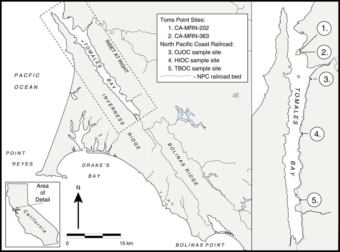
No previous studies have measured ∆R for Tomales Bay. The geographically closest published corrections are from loosely provenienced shell samples collected from Bolinas Bay (Robinson and Thompson Reference Robinson and Thompson1981) and Stinson Beach (Ingram and Southon Reference Ingram and Southon1996), both facing the open ocean. Due to differences in the local environments of these previously published corrections and our study area (a tidal estuary), we sought to determine the ∆R for Tomales Bay itself. As described below, we determined the regional ∆R through the analysis of pre-bomb shells from a museum collection as well as archaeologically recovered, and well provenienced, shell samples from a historical railroad grade of known construction date (Figure 1). These results are compared against four sets of paired shell and bone samples from archaeological sites at Toms Point, near the mouth of Tomales Bay.
Tomales Bay, with shell collection sites noted.

Environmental and Geological Context
Tomales Bay is a 25.5-km coastal estuary situated between the Point Reyes Peninsula and Marin Peninsula in western Marin County, California. This narrow, linear bay is approximately one kilometer wide and extends from the Olema marsh northwest toward the Pacific Ocean and Bodega Bay. Tomales Bay lies atop the San Andreas Fault Zone and is flanked by Inverness Ridge to the west and Bolinas Ridge to the east. This unique geological setting is reflected in a western shoreline comprised by metamorphic and granitic rocks associated with the Pacific Plate, an eastern shore featuring Franciscan Complex rocks associated with the North American tectonic plate, and three exposed headlands (Millerton, Tomasini, and Toms Points) dating to the late Pleistocene. The three headlands reflect the complex interplay between climate change and tectonic activity over the past 10,000 years. Three active strands of the San Andreas Fault bisect Toms Point (Grove and Niemi Reference Grove and Niemi1999).
Tomales Bay’s natural environments are equally diverse, consisting of forests on the Point Reyes Peninsula west of the bay and exposed grassy hills along the eastern shore. Perennial grasses, including bunchgrasses and other native grasses dominate the grasslands (now ranchlands) east of the bay (Avery Reference Avery2009:8). At the southern end of Tomales Bay, several creeks and tributary streams feed the freshwater Olema marsh, which is home to numerous bird species and other creatures that inhabit the protected reed habitat. This tranquil setting contrasts with the area around the mouth of Tomales Bay to the north, which includes windswept dunes and rocky intertidal habitat exposed to the waters of the Pacific Ocean. Eelgrass, waterfowl and shorebirds, invertebrates (clam, mussel, and oyster), bat ray, shark, and other schooling fishes thrive along the shores and in the warm, shallow waters of Tomales Bay.
Precipitation in central California occurs almost exclusively from October to March (California’s “water year” runs from October through September). However, annual precipitation varies widely, suggesting that the freshwater content of Tomales Bay is seasonal but inconsistent on an annual basis. Within those general parameters, freshwater inflow—from small streams and larger creeks like Lagunitas Creek (south) and Keys Creek (north)—is strongest during the winter months as the rainy season produces storm runoff. However, the outer bay has a near constant influx of upwelled ocean water; this signal reaches the inner bay most strongly during the dry season, typically April to July (Fischer et al. Reference Fischer, Smith and Churchill1996; Hearn and Largier Reference Hearn and Largier1997; Hollibaugh et al. Reference Hollibaugh, Cole, Dollar, Hager, Vink, Kimmerer, Obrebski, Smith, Valentino and Walsh1988). No snowmelt contributes to the hydrological system of western Marin County.
MATERIALS AND METHODS
Our study employs 14C dates obtained from the shells of six Pacific littleneck clams (Leukoma staminea) housed in the California Academy of Sciences Invertebrate Zoology Collection (CASIZ). These specimens were collected from Tomales Bay in 1913, presumably live. No further provenance information exists.
Coincidentally, the shell specimens were originally collected by Edward Winslow Gifford, an important figure in the history of California archaeology. Gifford’s career began at the California Academy of Sciences as a teenaged “student conchologist” in 1903. He later moved to the University of California, where he worked as both ethnographer and archaeologist, primarily focusing on Native Californian societies (Foster Reference Foster1960). One of his lasting contributions to California archaeology is the monograph, California Shell Artifacts (Gifford Reference Gifford1947).
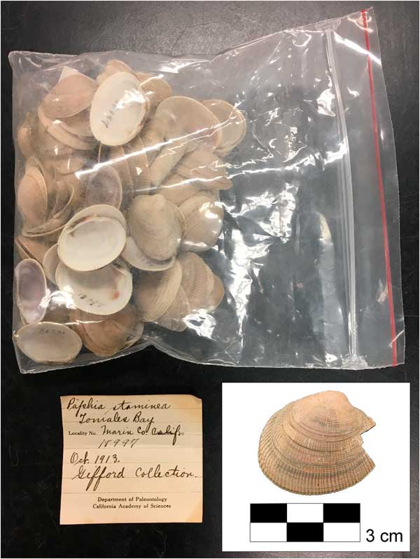
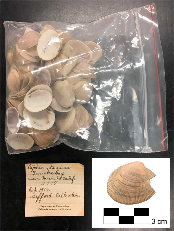
Following Goodfriend and Flessa (Reference Goodfriend and Flessa1997:141), we designed our sampling procedure to provide an average, rather than seasonal, value for the shells. With permission from CASIZ, we used a Dremel tool to remove an approximately one cm (ca. 0.08 g) wedge from the anterior margin of six clam valves (Figure 2). Although some shells in the collection were articulated, the samples included here were from individuals that had become disarticulated over the course of the past century of storage. To guard against duplication, only right valves were sampled. Clean shell samples from CASIZ were then sent to DirectAMS (Labcode, D-AMS), in Seattle, Washington, for accelerator mass spectrometry (AMS) 14C analysis. Chemical pretreatment at DirectAMS removed approximately 30 percent of each shell sample’s exterior surface to ensure removal of any secondary calcite adhering to the shell surface or between nacreous layers that may alter the apparent age. The remaining sample—a representation of the shell interior, or approximately 70 percent of the original portion submitted for pretreatment—was then crushed into a homogenous powder and an appropriate quantity taken for radiometric analysis. DirectAMS Radiocarbon Dating Service (2018) provides information on laboratory operating conditions (sample processing, measurement, and instrumentation) and can provide additional details on background and known-age standards upon request.
Leukoma valves from the collections of the California Academy of Sciences.
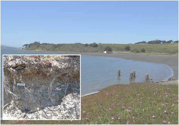
Because the known-age samples from CASIZ lack detailed provenience information, they cannot illuminate possible differences in the marine reservoir effect at specific points throughout the 25.5-km-long bay. To assess such possibilities, we included nine additional archaeological shell samples collected from three localities within the abandoned grade of the North Pacific Coast (NPC) Railroad where marine shell and gravels dredged from the bay were deposited as fill material during its construction in 1874 (Dickinson Reference Dickinson1967; MacGregor Reference MacGregor2003). The NPC line traversed roughly 19 km along the eastern side of the bay from its southern origin to Keys Creek. Surviving portions of the artificial grade along Tomales Bay exhibit a distinct shell layer roughly 30 cm below the modern ground surface (Figure 3), demonstrating that materials deposited as fill and base material were dredged from the local environment. Marine shell collected from different points along the length of the NPC line may therefore allow us to understand geographic variation in ∆R along Tomales Bay, though the resulting interpretations are complicated by the likelihood that dredging for such modifications incorporated both living and deceased mollusks.
Sample site along the abandoned grade of the North Pacific Coast Railroad on the eastern shore of Tomales Bay. Note shell layer in inset (scale in cm).
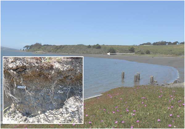
Shell samples from the NPC grade were collected in 2017 using standard archaeological practices at three equidistant sites that span over 12 km of the length of Tomales Bay (see Figure 1). To facilitate the identification of shells that had been dredged live in 1874, we submitted three specimens of Leukoma staminea from each of the three tested localities of the NPC grade for AMS radiocarbon analysis at DirectAMS.
Lastly, we examine four sets of paired marine shell and terrestrial faunal bone samples from archaeological contexts to assess the possibility of temporal variation in the ∆R of Tomales Bay. The samples were excavated by Panich and Schneider in 2015/2016 from CA-MRN-202 and CA-MRN-363, two shell middens located on Toms Point near the mouth of Tomales Bay. CA-MRN-202 is best known as the site of a historic-era trading post (ca. 1840s–1860s AD) but the site likely contains some late prehistoric deposits based on its presence as an active village site noted in mission records around 1820 (Panich et al. Reference Panich, Schneider and Byram2018; Schneider Reference Schneider2018). The sampled deposits from CA-MRN-363, in contrast, appear to date to the mid-Holocene, but our study (limited to a single 1×1 m test unit) has been the first to characterize the site. At each site, paired samples were taken from arbitrary 10-cm levels within broader stratigraphically determined contexts. As with the samples from CASIZ and the NPC grade, the AMS 14C analysis of the archaeological samples was conducted by the DirectAMS laboratory. Chemical pretreatment of shell followed similar procedures as those described above. DirectAMS’s laboratory pretreatment of bone samples for collagen extraction follows guidelines outlined by Longin (Reference Longin1971).
RESULTS AND DISCUSSION
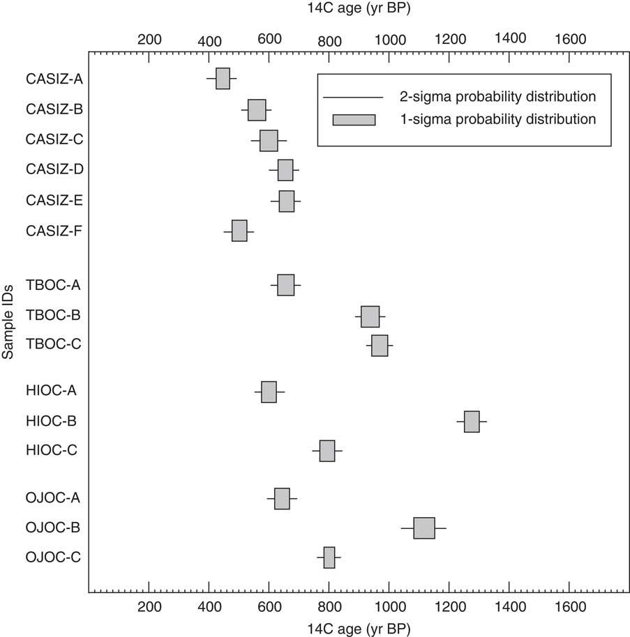
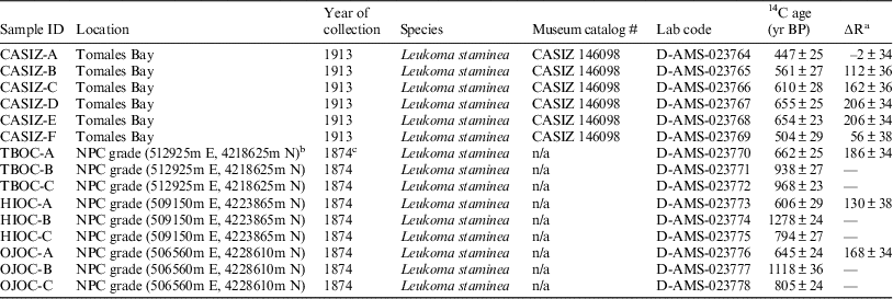
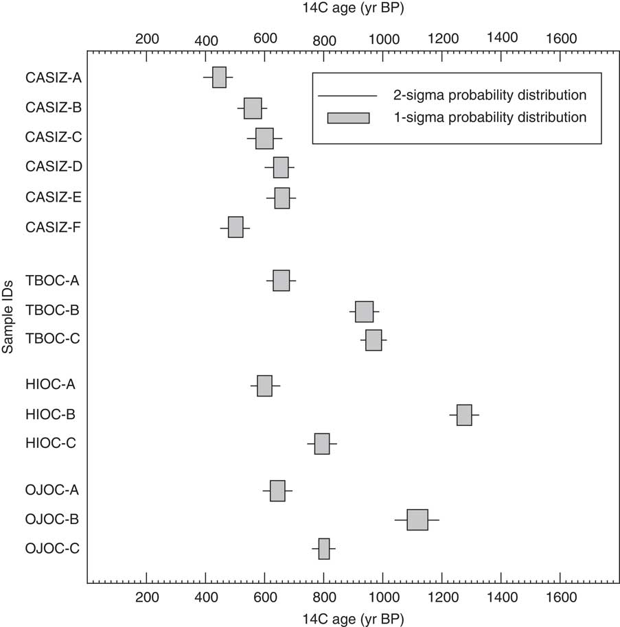
Table 1 and Figure 4 present the results of the AMS 14C analysis of the shell specimens from CASIZ and the NPC grade. ∆R values were calculated using the online tool provided by CALIB (Reimer and Reimer Reference Reimer and Reimer2016).
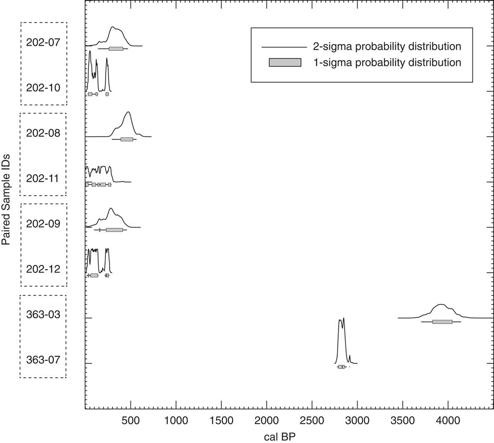
Conventional 14C ages for known-age shell samples from Tomales Bay listed in Table 1, showing one- and two-sigma distributions.
Radiocarbon ages and calculated ∆R corrections for known-age shell samples from Tomales Bay.

a Calculated via Calib (Reimer and Reimer Reference Russell, Cook, Ascough, Scott and Dugmore2016). ∆R not presented for NPC samples indicating reworked shells.
b UTM coordinates are all within Zone 10 S.
c Date of construction of the North Pacific Coast Railroad (NPC) grade along Tomales Bay.
The shells collected in 1913 and housed at CASIZ produced a relatively wide range of 14C ages and associated ∆R values. The variation in 14C ages subsumes roughly 200 14C years, and is generally consistent with the variation noted within pre-bomb shell samples from the northern California coast and the San Francisco Bay area analyzed by Ingram and Southon (Reference Ingram and Southon1996). The resulting ∆R values are lower than those currently calculated for nearby areas, perhaps due to the estuarine nature of the bay. Historical precipitation data for California’s north coast climate region indicate that water years 1910–1913 all saw below average precipitation, although the running precipitation mean (based on an 11-year window) was above average until water year 1913 (Abatzoglou et al. Reference Abatzoglou, Redmond and Edwards2009; Western Regional Climate Center 2017). While we could not obtain historical precipitation data local to Tomales Bay, the regional data suggest that shells collected in 1913 would not have been subject to abnormally high or low amounts of freshwater in the bay in the years immediately preceding their collection.
Shells from the NPC grade also exhibit a wide variety of 14C ages. The extent of variation points to the incorporation of both living and dead mollusks during the dredging of local bay sediments to create the artificial railroad grade at our three sample sites. However, the youngest samples from each site all produced 14C ages that overlap at 2 sigma (see Figure 4). This internal concordance, in addition to the similarity of the 14C ages of these three specimens to those of the CASIZ shell samples, suggests that these particular mollusks were living (or recently deceased) at the time of the grade construction in 1874. As noted in Table 1, we calculated ∆R for the three youngest specimens only, given the strong likelihood that the older specimens were long deceased when incorporated into the artificial grade. If indeed the three youngest samples were alive at the time of construction, the consistency of their 14C ages suggests that large spatial variation of ∆R does not exist for the inner three quarters of Tomales Bay, at least for the late Holocene. However, given the small sample size, radiocarbon analysis of additional samples would be needed to fully resolve this question.
Using the equations offered on the Calib website (http://calib.org/marine/AverageDeltaR.html; and see Bevington Reference Bevington1969), we calculated a weighted mean ∆R of 138±72. This value is based on the six samples from CASIZ and the three youngest dates from the NPC grade.
Comparison with Paired Samples
At CA-MRN-363, the shell sample yielded an uncorrected date much older than the terrestrial faunal bone. Using the online application developed by Reimer and Reimer (Reference Reimer and Reimer2016) we used these dates to calculate a ∆R of 1005±38 (and see Dettman Reference Dettman, Mitchell, Huckleberry and Foster2015). We caution that this value is strictly for the purposes of illustration, given that it is derived from a single paired sample from a poorly understood site (Ascough et al. Reference Ascough, Cook and Dugmore2005; Russell et al. Reference Russell, Cook, Ascough, Scott and Dugmore2011). Yet it is possible that significant temporal variation exists in the marine reservoir effect in Tomales Bay, as demonstrated in other regions along the Pacific Coast of North America (Ingram Reference Ingram1998; Taylor et al. Reference Taylor, Southon and Des Lauriers2007). Additional paired samples will be needed to test this hypothesis.
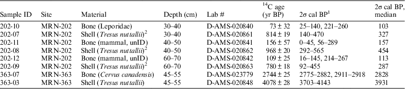
We did not use the paired samples from CA-MRN-202 to calculate ∆R, given the possibility of mixed late prehistoric and historic-era deposits as well as the increased uncertainty inherent in such recent 14C ages. We do note that the shell dates, corrected using the ∆R of 138±72 derived from the CASIZ and NPC samples, fall within the 2-sigma range for two out of the three paired samples; the third nearly overlaps at 2-sigma (Table 2; Figure 5). However, when compared to the median dates for the bone samples, the corrected shell dates all skew old.
Calibrated 14C ages for archaeological samples (terrestrial faunal and marine shell) listed in Table 2.

Radiocarbon ages for paired archaeological samples (terrestrial faunal and marine shell) from Tomales Bay sites.

1Conventional 14C ages calibrated using IntCal13 or Marine13 calibration curves via CALIB Radiocarbon Calibration, version 7.1 (Stuiver et al. Reference Taylor and Bar-Yosef2017).
2Sample reported in Apodaca (Reference Apodaca2017).
A lingering question regarding the apparent age gap between marine shell and terrestrial faunal bone in this portion of the study centers on the physical location of sites CA-MRN-202 and CA-MRN-363. Both are on Toms Point, approximately 2.5 km southeast of the mouth of Tomales Bay and 2.75 km northwest of our northernmost NPC collection site (see Figure 1). This landform is directly south of a wide tidal flat that attracts numerous modern clam diggers. If indigenous people living on Toms Point collected mollusks from the same clam beds, it is likely that the resulting archaeological shell would have a ∆R closer to that of nearby coastal areas outside of Tomales Bay itself.
The current weighted mean ∆R for Stinson Beach and Bolinas, the three geographically closest data points, is 259±48 (Ingram and Southon Reference Ingram and Southon1996; Robinson and Thompson Reference Robinson and Thompson1981; calculated using CALIB). This value, derived from open-ocean contexts, offers an additional offset of more than 120 years, despite the strong oceanic signal anticipated for the inner portions of Tomales Bay. The open-ocean value, moreover, returns calibrated dates for our shell samples that are more in line with the dates derived from the paired faunal bone from CA-MRN-202 and are also a closer fit to the known occupation dates of that site based on ethnohistorical data and diagnostic archaeological artifacts (Panich et al. Reference Panich, Schneider and Byram2018). Dating of archaeological deposits along the outer bay may therefore require the use of ∆R calculated from open-ocean samples. While these issues complicate the evaluation of the ∆R developed in this article, materials from Toms Point offered the only immediately accessible paired samples with which to test the local offset.
CONCLUSIONS
The analysis of known-age marine shell predating 1950 was used to calculate ∆R for Tomales Bay, California. Six specimens were analyzed from a museum collection obtained in 1913. Given the lack of detailed provenience for those specimens, we analyzed an additional set of shells excavated from three loci along a historical railroad grade constructed in 1874 on the eastern shore of Tomales Bay. The consistency of the youngest shells from each loci in this latter sample suggests little spatial variation in ∆R along the inner three quarters of the bay. Citing the good concordance between our two sets of samples, we used these nine values to calculate a weighted mean ∆R of 138±72 for Tomales Bay.
However, the literature indicates that ∆R values can vary significantly over short periods, even in the same marine environment. As with other regions of the northern California coast (e.g., Ingram and Southon Reference Ingram and Southon1996), the range in measured ∆R values for individual shell samples in our study suggests that the regional ∆R for Tomales Bay varies by approximately 200 14C years during the Late Holocene. Our correction value was tested against paired faunal and shell samples collected from sites at the outer portion of the bay, and comparison of the oldest paired sample points toward more significant temporal variation earlier in time. The results of paired samples from a late prehistoric/historic site generally overlap at 2 sigma, but the shell dates are universally older, indicating that areas near the mouth of the bay may have a larger local offset.
ACKNOWLEDGMENTS
We thank Christina Piotrowski, Elizabeth Kools, and the California Academy of Sciences Invertebrate Zoology and Geology Department for facilitating access to the historical shell samples. The Point Reyes National Seashore approved collection of shell samples from the NPC right of way and provided other material support; Michele Maybee and Benjamin Becker assisted with portions of this research. The Federated Indians of Graton Rancheria approved archaeological research at CA-MRN-202 and CA-MRN-363. We also thank Alyssa Tate at DirectAMS for assisting with our project. Two anonymous reviewers provided insightful comments on the original manuscript. Funding was provided by a National Science Foundation Collaborative Research Grant (BCS 1558987 and 1559666) to Schneider and Panich.