In his review of our Flying over Zerzura in Libyan Studies 52, Saul Kelly hinted at ‘some gaps in the coverage’ of Italian activities in the desert at that time. Such gaps refer to whether Captain Fabbri accompanied Almásy to Bir Messaha; a possible foray into the Sudan by the 1933 Marchesi expedition; the reason for Major Rolle's mission to ‘Ain Doua in September 1933. Though these particular events were not discussed in the book, during our research we discovered several papers and publications which provide satisfactory replies to all three questions.
The first question arises from the text of a letter dated 30 April 1933, written by Captain Cesare Fabbri (the interim Commander in Kufra during Rolle's absence) to HQ in Benghazi, through which he asked for permission to accompany Almásy to Bir Messaha, under the pretext that the trip was too risky to undertake with just the two vehicles available to the Almásy-Penderel expedition. We may assume from Fabbri's words that it was Almásy's idea to bring him along, with Penderel completely unaware of such an offer to the Italians.
This letter is currently kept in the W.B. Kennedy Shaw Papers at the Royal Geographical Society: it is one of the Italian documents Shaw took in Kufra at the time the LRDG was stationed there. Many items were of course to be found there, abandoned by the Italians after Kufra fell to the French, and Shaw was particularly interested in a set of pictures of the Sahariana ‘Cufra’ (which he later published in Long Range Desert Group, correctly crediting them to the Royal Italian Air Force) and in documents referring to Almásy, from which it became clear he had befriended the Italians and provided them with maps and information about the exploration of the Gilf Kebir. Copies of some of these documents have survived in Italian archives and we were able to find them; others, including Fabbri's letter, were nowhere to be found.
One Italian publication, though, provides indirect proof that Fabbri did not accompany Almásy to Bir Messaha. During the Thirties, the Italian Government Offices of Tripolitania and Cyrenaica published two more or less quarterly Bulletins, containing information of political and military interest relating to the colonies. The Bollettino Informazioni N.8 Aprile-Giugno 1933 from the Governo della Cirenaica – Comando Truppe (Government of Cyrenaica – Troops HQ News Bulletin N.8, April–June 1933) contains a short description of British activity around Kufra:Footnote 1
« British activity in the southern areas, specifically around the borders of Cyrenaica, Egypt and the Sudan has been very strong in the later years. The De AlmasyFootnote 2 expedition followed the Clayton expedition. Furthermore, during May – on the 5th – four big British aeroplanes reached ‘Uweinat from Cairo, crewed by 6 British Officers and 20 soldiers. » (Translation by the Author)
An in-depth description of the Almásy-Penderel expedition and its members follows, including how the Gilf Kebir was reached in 1932 by the previous expedition, the story of the three Zerzura wadis etc. This paragraph is interesting:
« As soon as he arrived in Kufra, De Almasy donated the map from which the attached tracing was produced. Last year he had promised that map to Major Rolle and, as soon as he had returned to Cairo he handed out a copy to our Legation. Having understood that it had not been delivered, he decided to bring along with him a second copy. » (Translation by the Author)
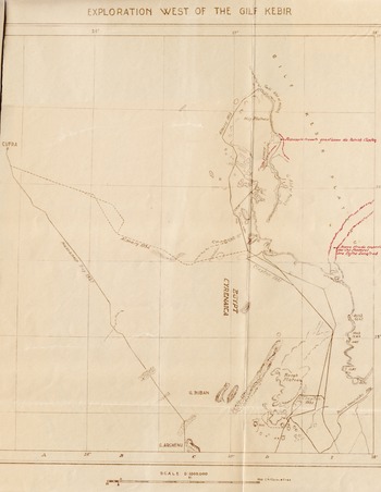
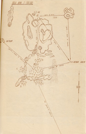
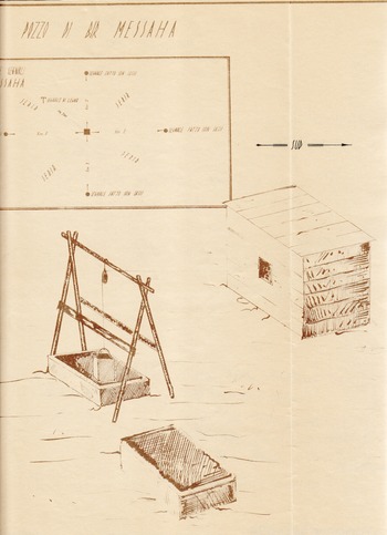
The Bulletin contains the 1:1,000,000 map ‘Exploration West of the Gilf Kebir’ (Figure 1) plus two original sketches that Almásy drew himself: a map of Merga (Figure 2) and the well structures at Bir Messaha (Figure 3). The Italian papers contain nothing else about Bir Messaha, apart from a short description of the well in the same Bulletin, where the information is said to have been provided by Almásy.
Map of the Gilf Kebir containing routes of the 1931 and 1932 expeditions by Clayton and Almásy. Handwritten sketches and notes in red ink highlight features described by Almásy to the Italians. Top: “Passage found this year by Patrick Clayton”. Centre: “New route found by Col. Penderel between Kufra and Farafrah”.
Source: Bollettino Informazioni N.8, Governo della Cirenaica, 1933. Fondo L8 Libia/177/1. Archivio Ufficio Storico Stato Maggiore Esercito – Roma.

Map sketch of the Merga area based on information provided by Almásy. The title reads “Sketch of the Merga area (from memory). Scale approximately 1:500,000”. The annotations on the arrows indicate the corresponding route length in days. The lengths between Merga and Bir Natrum Arremi and between the hill to Bir el Aosc Negal are “1-day march”; that between Bir Natrum Arremi and Bir el Aosc Negal is “2-day march” all the others “1 day and a half march”.
Source: Bollettino Informazioni N.8, Governo della Cirenaica, 1933. Fondo L8 Libia/177/1. Archivio Ufficio Storico Stato Maggiore Esercito – Roma.

Sketch and drawings of the well at Bir Messaha provided by Almásy. The map sketch marks the various cairns and signs surrounding the well: at a 2-km distance, aligned to the four cardinal points, four stone cairns are located (marked •), while 700 m towards NW there is a wooden sign (marked T). It is unclear whether the horizontal “south” arrow on the top right refers to the orientation of the drawing or the map, but the former is more likely.
Source: Bollettino Informazioni N.8, Governo della Cirenaica, 1933. Fondo L8 Libia/177/1. Archivio Ufficio Storico Stato Maggiore Esercito – Roma.

Interesting as it may appear, the simple fact that the Bulletin contains information and sketches provided by Almásy and not a first-hand description by some Italian Officer is sufficient proof that neither Fabbri, nor any other Italian, reached Merga on that occasion.
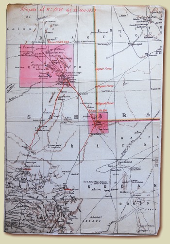
The second question regards the 1933 Marchesi expedition,Footnote 3 which had been ordered to survey the Kufra-Arkenu-‘Uweinat area and the border with Egypt that had been recognised with the 1925 agreements (Figure 4). The Ministry of Colonies was consulted about how far to extend the survey on the Sudanese side of ‘Uweinat and towards Tekro and Erdi to the south, in French Equatorial Africa.
Map indicating the boundaries of the areas where Marchesi's topographical survey was to take place. Dated 22 December 1932, it was attached to the final orders to the expedition, which was already in Cyrenaica, issued by the then-Governor of Libya Badoglio.
Source: Rilievi zona Cufra e Auenàt 1932–1933. Fondo MAI, A.P. b.53 Archivio Storico Diplomatico Ministero Affari Esteri - Roma.

In March, 1933, the Italian Ministry of Foreign Affairs sent notes to the UK and France through the Legation in Cairo and the Embassy in Paris, giving information about the forthcoming surveys and recognising the area east of 25° longitude as belonging to Egypt. Further orders to Marchesi also prevented any trip south of 20° latitude, to avoid any possible confrontation. For these reasons, no forays as far as Merga were ever made by the Marchesi expedition, which undertook just two short trips – each lasting a day and a half – to Jebel Kissu, Garet Chazzi and Yerguehda Hill, thus actually entering Sudanese territory but remaining well within the 26°E – 20°N limits.
The original map sketch from the expedition, kept in Florence at the Istituto Geografico Militare, clearly shows the routes they travelled, and includes a note in red ink, stating that ‘according to higher orders, no surveying was made south of 20° latitude’.
Finally, another 1933 letter, this time written on 18 September by Major Rolle to HQ in Benghazi, contains a report of his mission to ‘Uweinat, where he had been sent some days before to welcome the crews of two Vickers Victoria aircraft of RAF No. 216 Sqn. from Cairo on a reconnaissance trip. This document, just as Fabbri's letter above, could not be found; however, the Italian archives contain most, if not all, the correspondence leading to the mission and following it.
We must remember that the border between Cyrenaica and the Sudan was then still an open issue between Italy and the United Kingdom. The 1932 Bagnold expedition had been welcomed by Lorenzini and Rolle as if those areas were fully belonging to Italy, but a formal declaration had yet to be made.
A message by the British Embassy in Rome to the Italian Ministry of Foreign Affairs, dated 18 July 1933,Footnote 4 points out the differences in the views of the two countries and specifies that, though the Italians had built landing grounds at ‘Ain Doua and Sarra, no agreement had been reached and the Royal Air Force was expected to keep on reconnoitring the area ‘in the normal execution of their duties’. At the same time, both Governments were exchanging views through their Embassies and Ministries and were confirming their will to reach a formal and final agreement on the border between Cyrenaica and the Sudan. Along with diplomacy, both countries kept on meeting on the ground in the disputed area, the British usually sending some RAF aeroplanes to ‘Uweinat and the Italians placing troops to welcome them, to show that the area was constantly garrisoned and under Italian control.
Rolle's September 1933 mission was simply one of those ‘desert meetings’, and had been required by news that British aircraft were scheduled to reach ‘Uweinat on or around 10 September. The trip had been duly announced by the British to the Italian Embassy in London, not a secret reconnaissance at all but, as we have seen, the usual ‘exchange of pleasantries’ between the two countries, which would lead to the November 1933 talks in Rome and to the 1934 agreement.