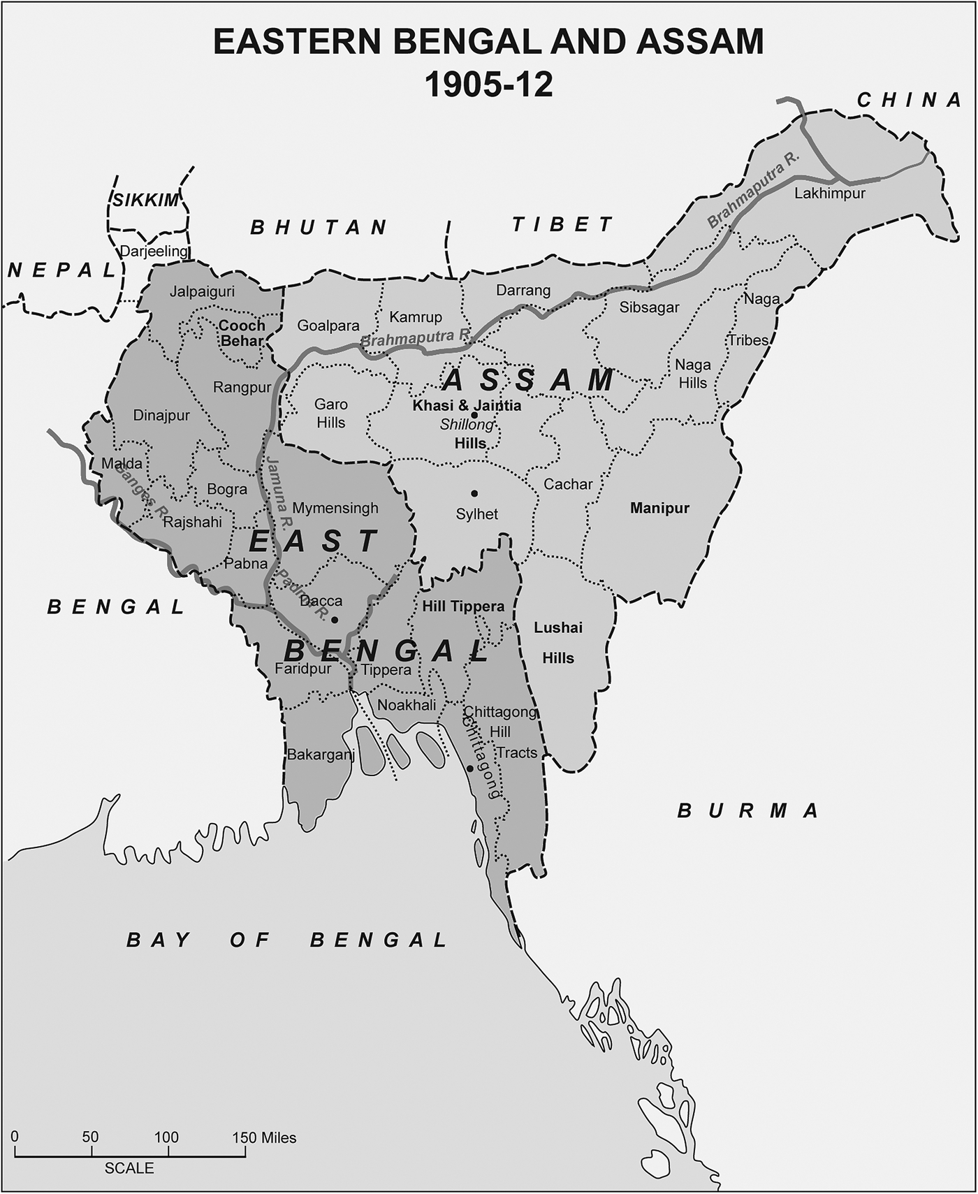

The constitution of the province of Eastern Bengal and Assam in 1905 (see figure 1), through the partitioning of Bengal, was a remarkable event that ignited a half-awakened Indian nation. By this time, the spatial integrity of Bengal, was considered so settled that Gandhi (Reference Gandhi1984, 121) wrote from South Africa that even the real founders of the British empire in India would have opposed the idea of partitioning the province, if they were to rise from their graves. The new province was annulled six years later, bestowing the first major political victory for the nationalists who had perceived the province as a communally motivated divide-and-rule ploy of the empire. Ever since, most literature on Indian nationalism has made this event a favorite point of departure, while the province itself remains nonexistent in the temporal slate of the nation. The colonial administration and Eastern Bengal loyalists, on the other hand, saw the move as a practical ameliorative, cutting an unmanageably large area into a smaller administrative unit with Dhaka as the capital (Molla Reference Molla1981). Thus both the opponents and the protagonists of the Eastern Bengal and Assam Province tied their arguments with certain bordered territory as a site for economic and political wellness.
The Eastern Bengal and Assam Province (Bradley-Birt Reference Bradley-Birt1906, 342).

Recent studies on modern India have taken new turns by situating the nation and the empire within forms of spatial imagination and politics, adding new meanings to the partition of Bengal in 1905 along with the partition of India itself in 1947. Manu Goswami (Reference Goswami2004) looks at the emergence of a territorially bounded nationalism since the mid-nineteenth century, reaching a major milestone through the Swadeshi movement that was initiated against the new province of Eastern Bengal and Assam. She suggests that both the occasions reflected on how national imagination mediated the universality of capital and delimited the spatial basis of nationhood.Footnote 1 Ludden (Reference Ludden2012) examines the ways in which the annulment of the province of Eastern Bengal and Assam in 1911 at the face of national movements contained the seeds of India's own imperial vision of a bounded territory in which “spatial inequity” was ingrained.
The recent debates, in seeking to explain the discursive convergence between the nation and the empire in a universal capitalist but territorially bounded world, represent a powerful assimilation of Anderson's (Reference Anderson1991) imagined community and Henri Lefebvre's (Reference Lefebvre1997) production of space. Such debates reengage Indian nationalism by taking a “map in the mind” in which “territorial centralization of social relations” or “internally unified markets” were taking shape (Goswami Reference Goswami2004). These studies on the spatially iniquitous variables of “nation building” process travel up to the existing border of the Indian nation, but are hesitant to cross it. In the light of recent transregional studies (Duara Reference Duara2010; Scott Reference Scott2009; Yang Reference Yang2008) there is also much to argue that while the nation was digging on the national-imperial spatial curves, flows of ideas, commodities, and capital continued to travel across the borders. Yet between an impressive array of critique of the nation and a remarkable inclination towards macro-history, the story of spatial dialectics between the nation and the empire remains understudied. There were far more critical relations between the empire and the nation, not merely in terms of politics of representation and power, but also about space. The question that ensues: how did the spatially sensitive nation approach transnational agility at a time when the empire loomed large?
The constitution of the province of Eastern Bengal and Assam and the resultant national resistance offers a window to this question. As the British-Indian empire stimulated transregional gravity towards Southeast Asia and southern China, national opposition to such imperial vision made a strong case for the status quo for a nation-state that was in the making. This article argues that a romantic notion of the agro-ecological possibility of the Bengal Delta, rather than the empire's transregional quest for market and mobility, fueled the spatial politics around the new province of Eastern Bengal and Assam. An analysis of the spatial contests between the empire and the nation has clear implications for contemporary debates on regionalism and transregionalism in South Asia, Southeast Asia, and southern China.
The Empire Looks East
The imperial gaze east of Kolkata was boosted by an emerging set of issues visible by the early nineteenth century. The financial losses of the East India Company arising from the decline of the textile industry in India and the cost of the inflexibility of the permanently settled revenue system were becoming all too clear.Footnote 2 Financial constraints demanded that the city of Dhaka regain the capacity to generate revenue, resulting in renewed interest in the revival of the city as a new, geographically suited commercial hub. Charles D'Oyly's (Reference D'oyly1830) poignant sketches of Dhaka's environment and architectural relics evoked nostalgic memories of it as a Mughal metropolis. Bishop Herber reported in 1824 that Dhaka was “merely the wreck of its ancient grandeur. Its trade is reduced to one-sixteenth part of what it was; all its splendid buildings, the palaces of its ancient Nawaubs, the factories and churches of the Dutch, &c, all sunk into ruin” (Brown Reference Brown1847, 47). A desolate-looking Dhaka reminded an English trader of the drainage of silver from Bengal to England, its disappearance from the trade of the eastern Indian Ocean, and so on:
The muslins of Dacca, that beautiful manufacture which was to Bengal what the manufacture of steam engines is to England, absolutely unsurpassed, has, within living memory, become utterly extinct. I possess positive proof that the cotton-plant from which it was fabricated, grown immemorially on the rich banks of the river Megna, has become extinct with it, and that the weavers have been swept off the face of the earth. (Brown Reference Brown1847, 47)
The book that contained the code of Dhaka's revival came from James Taylor (Reference Taylor1840), published at a time when global trade and commerce were increasing. It emphasized the fact that Dhaka was not faring as it used to in terms of trade, demography, and social mobility. In the decades that followed early imperial concerns for Dhaka, the city's slow but steady regeneration was observed, while its rivers, the Buriganga and the Shitalakhya, became its nerve lines that connected the Bay of Bengal. By the 1870s, Dhaka's commercial hub, Narayanganj, dubbed as the Dundee of the East, was considered an ideal port to connect the Bay of Bengal, as large ships could easily come up to it through the Shitalakhya river.Footnote 3 By this time, jute proved to be the catalyst for sustenance of the emergent interest in Eastern Bengal.
If by the second half of the nineteenth century Dhaka's geographical and agro-ecological locations made it a fitting outlet to the Indian Ocean, other developments took the imperial gaze further east. The northeastern borders of India were subject to geological investigations for minerals as early as the turn of the nineteenth century (Colebrook Reference Colebrook1822), but it was tea in Assam that practically pushed the empire to the next spatial horizon (Sharma Reference Sharma2011). As jute of Eastern Bengal and tea of Assam were visible items in the imperial bazaars, Chittagong port began to catch up with Kolkata port. The spatial triangle of Dhaka, Assam, and Chittagong made more sense on account of some developments that were informed by the lure of further east towards southeastern Asia and southwestern China.
When in 1765 a young James Rennell, later the first Surveyor General of India, was employed to find the shortest and most convenient Ganges waterways for transporting commodities from the eastern Indian hinterland to Kolkata port, he was annoyed by the way the English mostly wanted to find the shortest trading route, whereas in such case the French would prefer first seeking scientific knowledge of a landscape. Rennell, however, did his official job quite well, and while doing so he became the first European to discover the river Brahmaputra. The identification of the Brahmaputra alerted him to an eastward direction, as he pointed to the fact of the Brahmaputra's proximity to Yunnan by 220 miles. His discovery of the Brahmaputra also prompted him to examine the navigability of the Irrawaddy river from the city of Ava to the province of Yunnan (Rennell Reference Rennell1781, 111–12). The geographical debates that ensued in the following decades among British scientists, surveyors, and explorers were closely connected to the question of communication between Bengal, Southeast Asia, and southern China by means of rivers instead of the Straits of Malacca, particularly during the monsoon (Huttman Reference Huttmann1844, 123).
Rennell's findings and hopes were revived by Arthur Cotton in the 1860s. Cotton argued that the shortest possible line that could connect the Chinese heartland of Yangtze with India would be the line between the Brahmaputra and the Yangtze, the distance between the nearest navigable points of which was 250 miles, just about the distance Rennell had calculated. Cotton also assumed, erroneously, that there could be points where the distance between the two rivers could be as short as 80 miles. Cotton drew much of his inspiration from the remarkable interest and development in water transport in France and the United States. With the arrival of the railways, the empire's “extra-Indian” adventure took a new turn, as reflected in the idea that the first railway line in Eastern Bengal, from Kolkata eastward to Dhaka via Nadia, was meant to be a starter for a route from Kolkata to Canton (Cotton Reference Cotton1866–67, 257). In the next few decades, Eastern Bengal and Assam emerged as new spatial springboards from which to look towards China and other areas of mainland Southeast Asia.
One of the two lines of communication from India to China being considered ran from Chittagong towards Yunnan via Bhamo and the other across the Shan states. The Yunnan-centric approach helped Chittagong and Yangon emerge as two important China-bound transit points in addition to being outlets to the Indian Ocean. Another route, as suggested by Josh McCosh, that was to connect Dhaka, Sylhet, Manipur, Ningtee or Kyen-duen river, upper Burma, Bhamo, and Yunnan appeared to have the “advantage over every other route.” In the mid-1870s, it was argued that the Chittagong-Mandalaya route was the “shortest and direct” one for a possible connection between India and China (Hay Reference Hay1875). A Yunnan-centric line of communication was driven by the so-called “Yunnan myth” that it was a province with huge mineral wealth, prompting more than twenty explorations into Yunnan and surrounding areas in the course of the nineteenth century (Walsh Reference Walsh1943, 272–73). Such shifts in the regions took place at a time when it was felt that overland trade between China and Myanmar was freer and more independent than that between China and Russia (Sprye Reference Sprye1858, 5). Aiming for an entry to the “ultra-Gangetic” peninsula, the British believed that the opening of southern China through Yangon would not clash with British trade along China's eastern coastline (Duckworth Reference Duckworth1861, 22).
By the 1860s, the British were increasingly uncomfortable with the greater presence of other imperial powers, especially the United States in Shanghai and other Yangtze delta regions. Therefore, the idea of preemptive efforts to get to the Yangtze valley through what became known as the Irrawaddy Corridor emerged. Edward Sladen, the British political agent at the court of the last Burmese King in Mandalay, was particularly worried that the Americans were soon going to take control of trade along China's eastern coast. He saw this in the “hot haste” with which the Americans were constructing the Atlantic and Pacific Railroads and seeking a Euro-American consensus about opening a ship canal across Panama to connect the Atlantic and the Pacific. Because of the issues that he termed as “collateral reasons” and “contingency of US predominance,” and in the context of the decline of the opium trade along with the Canton System, Sladen suggested that the British should find a western doorway to China. He felt that a route to China through Burma would be of “highest importance” (Sladen Reference Sladen1869, lxi).
In its 1899 conference, the Associated Chambers of Commerce, represented by over seventy chambers of commerce in Britain, recommended that, under the vigorous railway administration of Lord Curzon, Chittagong should be connected with Kolkata in the west and the Mandalay-Rangoon Railway in the east. It felt strongly about this, as Russia had got hold of Taiwan, and France, after taking control of Tonkin, was pushing forward a railway line to Yunnan (Times [London] 1899). By 1904, the British Indian government reached an agreement to construct a number of routes from Burma to China on behalf of the consul-general in Yunnan. A good road had been constructed by the Burmese government from Bhamo to the frontier at Kulikha, and with the consent of the local Chinese authorities this road extended from the frontier through the gorge of the Taiping on the left bank of the Irrawaddy opposite Manwaing. The cost of construction was advanced by the Burmese government, and the Chinese had agreed to repay the money out of the proceeds of mule-tax by three-year installments (Rice Reference Rice1904).
The volume of India's trade with China on the Myanmar frontier was much lower throughout the nineteenth century than that between India and China's eastern coasts. However, between 1896 and 1899 it increased by nearly 30 percent. This increase was not due to new railways, but a ripple of “extraordinary” effect produced by the little and still incomplete line to Kunlon with the Shan States and Zimme (Chiang Mai)—an increase of 55 and 90 percent, respectively, observed in four years. It was hoped that when a full-length railway would be built into Yunnan, the trade with western China would “go up by leaps and bounds” and that Lord Curzon, “from his own acquaintance with Downing Street, [had] better opportunities of bringing them under official notice than any of his predecessors” (Boulger Reference Boulger1901, 690).
Northeastern India's trade link with China and Myanmar became visible in the context of certain other developments in Dibrugarh near the Assam-Myanmar borders in the Brahmaputra valley. Organized production of tea and coal began in the northernmost parts of Assam bordering Tibet and Myanmar, which prompted a lot of mobility among local boats, steamers, and finally the railways. By 1885, the Eastern Bengal Railway line, which covered about 600 miles, connected major coal and tea sites with the Brahmaputra river and Comilla town near Dhaka on the one hand and the Chandpur river port and Chittagong sea port on the other. An increased connectivity between the hilly “hinterland” and the Bay of Bengal led to the possibility of linking up Eastern Bengal and Assam with Myanmar through a possible line from Dibrugarh through the Hukong valley to Mogoung on the Upper Burma Railway System (Shakespear Reference Shakespear1914, 67–70).
Curzon, as it appears, arrived in India at a time of great transregional thrust across its northeastern borders. He soon took initiatives to justify the constitution of the new province through spatially specific arguments. In his speech in Dhaka, which was part of his publicity trip to Eastern Bengal immediately before the formation of the new province, Curzon referred to the commercial enterprises of Eastern Bengal during the Muslim rule and argued that the new province must “develop local interests and trade to a degree that is impossible so long as you remain, to your own words, the appendage of another administration.” He felt that such development around Dhaka “would go far to revive the traditions which the historical students assure us once attached to the Kingdom of Eastern Bengal” (Curzon Reference Curzon1903–5). This and other similar statements patronizing Bengali Muslims by the lesser officials of Curzon, to date, remain the master clue to the imperial machination to weaken Indian nationalism through fueling communal politics. Yet, in Mymensingh, Dhaka's neighboring district, Curzon's carefully drafted arguments were specifically directed to local Hindu elite. He pointed out that the administration was offering the Bengali nation
the opportunity of forming a second unit round a second centre; and if a reduplication of its political existence is to be regarded as injurious to its future, Bengal nationality must, I think, be very distrustful of its own powers. It is curious that among the appeals that have been addressed to me, frequent allusion is made to the fact that Eastern Bengal once constituted an independent kingdom, the people of which, I believe, still call themselves Bangals, and not Bengalis. And yet, when the offer is made of a resurrection of that unit, the objection is raised that history and nationality are both being flouted and ignored. (Curzon Reference Curzon1903–5)
Risley, his deputy, merely repeated Curzon's racial overtone of the Mymensingh speech when he said that Muslim interest in Dhaka as the capital would be strongly represented if not predominant and he hoped that would also bring under Assam the “whole of population variously known as Koch, Rajbansi, Paliya, etc., which is of mongoloid origin and differs essentially from the Western Bengal type” (Risley Reference Risley1905, 30–31).
The whole process of constructing the new province of Eastern Bengal and Assam was informed by a sense of the “natural” and “nature.” In his speech in Chittagong, Curzon remarked that Chittagong's “natural destiny” was to be the principal outlet of the trade of Eastern Bengal, implying the clear importance of the city's links to the Indian Ocean. In fact, the Chittagong port was an integral part of the scheme of the new province (Osmany Reference Osmany2007, 77–78). Given the ecological setting of Eastern Bengal, the new province got all the districts on the east bank of the lower Ganges and the districts on both sides of the Meghna and Brahmaputra rivers, with its capital in Dhaka. Joseph Bampfylde Fuller, the first lieutenant governor of the new province, appreciated that Chittagong would be the “natural” commercial outlet for both Assam and the Dhaka and Mymensingh districts. He thought that although the associations of these two latter districts had hitherto been almost exclusively with Bengal, the connection between them and Kolkata was from a physical point of view both “arbitrary and unnatural,” the numerous intervening rivers of Eastern Bengal rendering communication difficult and slow. On the other hand, the geography of Eastern Bengal was considered to have developed a “mental characteristic” of the people of the region (Fuller Reference Fuller1902). Chief Secretary to the Bengal Government Macpherson argued that it was extremely desirable that the new province should have full control of the Ganges and the Meghna rivers with a view towards their improvement as navigation channels. The principal outlet for the commerce of Dhaka and other important ports of Eastern Bengal rested in the waterways these rivers afforded. According to Macpherson, the riverine environment and the alluvial landforms shaped the character of the people of the region (Macpherson Reference Macpherson1904, 149).
For Assam, relaxed labor relations were mooted, albeit in a hesitant fashion. Fuller argued that the proposed boundary of the new province would include almost the whole area the Tibeto-Burmon tribes of Bodos had inhabited and hoped that the province would bring together under one government the tea-growing areas of the Dooars and of the Assam Valley. Such a process of introduction of free labor in an area full of indentured labor, Fuller (Reference Fuller1903, 13) hoped, would promote the “gradual substitution of natural for artificial methods” in the requirement of tea coolies.
The Curzon administration's multiple languages of public engagement, such as the liberal overtone of labor relations in Assam, the demographic reshuffling in Myanmar, the Muslim communitarian revival in Dhaka, and a racial trajectory in Mymensingh and Assam, were drawn together to rehearse a policy to suit a manageable spatial arrangement in the form of a new province, which was clearly focused on Southeast Asia and southwestern China along with the Indian Ocean rim that connected these regions. Yet, it was the imperial point of departure in Eastern Bengal rather than its expanding transregional terrain of exploitation beyond the border of India that raised the nation's wrath.
The Inner Line of the Nation
If the empire looked to a larger spatial domain of mobility of humans, commodities, and ideas, the national imagination settled on a boundary that made little sense beyond a more inward lore of the agrarian. Politics, patriotism, and palliatives for economic woes—all expressed themselves centrally in terms of the land and landscape of Bengal. It is possible to appreciate the urgency to return to an agrarian domain of productivity in the context of global trends in resource uses. By the 1880s, in Europe the space for colonization had all but gone, and in the United States a similar sense of limited space induced Frederick Jackson Turner's announcement that the frontier had “closed” and the Gilded Age was over. The phrase “fin de siècle” was coined, and the decade of the 1890s resonated: “decade, decayed, decadence” (Williams Reference Williams2006). In Bengal most fertile areas were already occupied and under cultivation, and parts of the Sundarbans forests were cleared up to the sea. Western Bengal had been hit hardest in the course of the nineteenth century. As the much quoted “moribund delta” thesis suggests, a dying river system and ravaging malaria had rendered a vast portion of the region as decadent tracts that largely depended on the produce of East Bengal (Iqbal Reference Iqbal2010).
A cultural signifier that would transcend spatio-ecological asymmetry within Bengal was a call of the time. Aurobindo Ghose, a spirited Cambridge graduate, speaking in the Eastern Bengal town of Kishoreganj in 1908, asserted that “Swaraj begins from the village” (De Reference De2003). To situate the countryside and agriculture within the national project required the invocation of an agrarian past that was simply prosperous, a spell of imagination which Prathama Banerjee called a “manifesto for practice.” In other words, the invoking of the agrarian past as a prosperous one was not to aspire for or justify chronological truth, but to do things in the future (Banerjee Reference Banerjee, Mayaram, Pandian and Skaria2005, 295–96). In this context, the specific metaphor of “Sonar Bangla” (Golden Bengal) that flooded Swadeshi literature is significant because the term, most powerfully used in a poem of Rabindranath Tagore that became Bangladesh's national anthem, represented an unprecedented romantic gravity towards the ecological features of Eastern Bengal.
If the invocation of a golden agrarian past was required to awaken a “dying nation” to the importance of the countryside and agriculture, it was placed within a complex reinterpretation of race, religion, and caste. In an attempt to recover the agrarian self of the Hindus, Pitambar Sarkar (Reference Sarkar1910, 136–37) wrote that all major saints since the ancient times had considered the Brahmin, Kshatriya, and Vaishya castes as dwijati, that is, of the same social denomination, although they had designated the profession of agriculture specifically to the Vaishyas. The Bhagwat Gita, according to Pitambar, considered agriculture as a “natural” profession for the Vaishya and something that the Brahmin themselves could take up at times of “emergency” (apadkala). Parashar of Kali Yuga (modern times), however, believed that the Brahmins could take up agriculture even without an emergency situation. Those who were already in agriculture but not considered one of the high castes, such as the Haldhar, were also given due attention in the new scheme of agriculture as a vocation. Jadunath Majumdar ([1918] Reference Majumdar2007, 56, 66–70) wrote that the Aryans were meant for agricultural work and they developed caste only when they were settled. Noting that the Hindu society had become joro (stale), he suggested that the Brahmins should embrace the Namashudras and other low castes in order to stop the process of national decline—an act that appeared as defeat but in reality was victory in a broader political spectrum. Within the program of the nation, the Muslims were not entirely excluded. Pandit Rajanikanta wrote: “Say brother ‘Allahu Akbar’ [Allah is Great] / we are thirty crore brothers all connected, no one is different from each other / with plough on the shoulder, sickle in the hands come brothers / we Bangalis will sow gold in the gold-producing fields” (Iqbal Reference Iqbal2010, 95). If an imperial version of liberalism sought to embrace racial equality for greater mobility of labor around new investment opportunities in multiple transregional sites, a variant of liberal nationalism sought to close the communal and caste gap to ensure the supply of labor for a specific domain of agriculture. But in this case, cultural expressions not only preceded capitalist development, but also practically resisted the imperial mobilization of capital.
Within this renewed interest inland, the question of the Permanent Settlement assumed particular significance. The urge for the revival of Dhaka in the early nineteenth century, as noted above, was closely followed by intensive commercialization of agriculture in different locations in Eastern Bengal, which led to maximum utilization of wastelands, particularly on the alluvial landforms, the Sundarbans forests, and coastal belts, most of which lay beyond the jurisdiction of the Permanent Settlement (Iqbal Reference Iqbal2010). By the 1870s, the colonial administration, including lieutenant governors George Campbell and Richard Temple, began to appreciate the relative economic buoyancy in Eastern Bengal in the context of the absence or reluctant enforcement of the Permanent Settlement. This is one area on which R. C. Dutt, a prominent nationalist economist, and Fuller exchanged heated commentaries. Although both agreed on the relatively better index of the Eastern Bengal economy and wellness, they disagreed on the role of the Permanent Settlement in this. Refuting Dutt's contention that the Permanent Settlement contributed to Eastern Bengal prosperity, Fuller (Reference Fuller1902) argued that any idea of linking the Permanent Settlement to Eastern Bengal economic conditions would be “strangely to mislead history.” Fuller suggested that such a hypothesis was not rendered more plausible to the Government of India by some of the nationalists' complete inability to endorse the accompanying facts. He argued that Bengal, especially Eastern Bengal, possessed “exceptional advantages in its fertility, in its comparative immunity from the vicissitudes of climate to which other parts of the country are liable, in its excellent means of communication, in its enjoyment of a practical monopoly of the production of jute, and in the general trade and enterprise which radiate from its capital city, comfort and prosperity” (Fuller Reference Fuller1902, 2–3). The argument in favor of opting out of the Permanent Settlement made equal sense for Assam, where five of its six districts already lay outside the jurisdiction of the Settlement.
Fuller's publicly expressed negation of the role of the Permanent Settlement could be read against the rumor that the government was going to get away with it in the new province of Eastern Bengal and Assam. An anonymous writer, X, in a Kolkata-based newsmagazine suggested that he had made “all kinds of mental allowances” for his “Occidentalism as opposed to Orientalism” and that he had honestly tried to place himself in the position of a Bengali, but the reason put forward in public had never quite satisfied him. He went on to claim that Bengali land owners and property owners were seized with the “great fear” that Curzon's partition policy had only come to the statute book as being the first step towards the abolition of the Permanent Settlement. X thought that that was the “real and the chief cause of all of this excitement” and that the issue of the Permanent Settlement was the fona et origo mali in this connection.Footnote 4 This apprehension qualifies Curzon's suggestion that they “should all probably be just as glad to see no temporarily settled districts under Bengal officers who know little or nothing about them, as we should be to see the Permanent Settlement disappear altogether” (Curzon Reference Curzon1903). As the colonial administration thought of discontinuing the Permanent Settlement and setting a new parameter of property right in the new province, the nationalists found plenty of reasons to oppose the move. For although in Eastern Bengal and Assam most of cultivable lands remained outside the jurisdiction of the Permanent Settlement, a considerable amount of land, including some large and medium-sized estates, were left with the landlords under the Settlement. By the turn of the century, small-holding peasant lands were also becoming popular sites for retreat for the urban middle class for basic security of food at a time of diminishing ecological resources and lack of capital formation among the Bengalis since the mid-nineteenth century. If the Swadeshi ideals were tied with the countryside, it had to be in a countryside that was capable of catering to the basic material needs of the nation. In other words, the agrarian milieu that the empire found no longer adequate for greasing up the imperial machine was now more ardently embraced by the nation.
For the empire, however, the frontier did not end at the borders of Bengal, as Myanmar and Assam provided new avenues of, among other things, agriculture and trade. While the empire had already targeted the spatial domains between Kolkata and Canton, the nation seemed to stop right at the plainland stretching between Kolkata and Chittagong. In this equation, Curzon's role needs to be reevaluated. Curzon visited Burma before he visited East Bengal, and he gave a speech to the Rangoon Chamber of Commerce in August 1902. He did not seem to be in favor of land communication between British India and Burma, neither through the Assam-Bengal Railway from Makum across the Hukong Valley to the Chindwin nor through the Manipur route, but Curzon had “little doubt that the connection with Bengal will come.” He thought it “will be demanded by the increasing development of this province, the great need of which is, and will long continue to be, population. . .and no doubt connection by land with the teeming population of British India is a great desideratum. ... But my own impression is that the sea will become less of a barrier with every year that passes, and that, as the province develops, it will attract a much larger number of the immigrants whom it desires” (Curzon Reference Curzon1902, 382–83).
The nationalists' emphasis on the exclusive ecological domain of Eastern Bengal sharply contrasted with that of the new province of Eastern Bengal and Assam as a center point for mobility across mainland Southeast Asia and southwestern China. The competing visions of territoriality and questions of economic wellness within the ecological contingencies raise the question of whether they might be understood through the perspective of global capital flows, or through what Sartori (Reference Sartori2008) examines as a cultural turn. The new province, which would force the nationalists to adjust to uncertain prospects in the relatively unfamiliar city of Dhaka, was not a good idea. Therefore, “Swadeshi was the answer, which also targeted one of Curzon's real motives for creating the new province, to attract foreign investments” (Ludden Reference Ludden2010, 24). The national venture of securing the convergence of the spatial integrity of Bengal and the Bengal capital in Kolkata sowed the seed of what Ludden (Reference Ludden2010, 7) called India's own imperialism and spatial inequality: “1905 marked India as an imperial nation.” Yet, the political agenda of Curzon to displace Kolkata as a Congress hub was achieved through relocating the imperial capital to Delhi without much resistance—which undermined any specific imperial or national investment agenda in the colonial metropolis of Kolkata. Andrew Sartori (Reference Sartori2008) suggests that the decline of Bengali capitalist endeavors in the early nineteenth century ended a spell of liberalism in Bengal, giving way to a form of cultural ideologies, as opposed to commerce. This cultural turn was closely associated with a passionate call for agrarian activities, which was then considered ethically binding.
Sarat Chandra Chattopadhyay, widely considered the most popular Bengali writer after Rabindranath Tagore, offers a glimpse of these national tendencies soaked in agro-ecological imaginations. Chattopadhyay, after returning to Bengal from Myanmar, got involved in Congress politics and became Congress president of the district of Howrah in West Bengal. As he was traveling to Eastern Bengal with Chittaranjan Das, one of the few politicians who worked for an inclusive and noncommunal national space for Bengal, a late-night open-air conversation between them during a river tour in Barisal ran like this:
We both sat on the deck of the steamer. Deep darkness all around. Some stars peeped through the slightly cloudy sky. The steamer was running through numerous bendings of the meandering river, its powerful search light falling sometimes on the boats anchored on the bank or on the branches of the trees or sometime on the cottages of the fishermen. After remaining silent for a long time, Deshbandhu [honorific title of “Friend of the Country” given to Chittaranjan] suddenly spoke out: Saratbabu, those who aren't born in this country don't know what nadi-matrik [riverine country] truly means. We must have it. (Chattopadhyay Reference Chattopadhyay1970, 295–96)
The ecological significance of Eastern Bengal, among other issues, set the context of the conversation that night. Chittaranjan's reconciliatory, inclusive politics of nationalism was informed by an inverse logic of maintaining the agro-ecological heartland of Bengal. It was a practical passion for land and landscape that offered survival for those whose spatial imaginations largely rested on the plains of the region. Such subjectivity depended on several contingencies. The Swadeshi agenda to revive rural Bengal meant that Eastern Bengal remained a legitimate spatial domain of self-sufficiency. The passage of the conversation certainly reflected on the late nineteenth-century cultural turn of the Bengali nation and was a clear example of the vision of a bounded nationalism, but these developments could well have been epiphenomenal to some ecologically specific questions that undermined the capitalist discourse of national imagination.
It is important to note here that the Indian nationalism spawned by the Swadeshi movement was not a quintessentially home-bound project. The battle of spatial imagination and political practices between the empire and the nation in India also took place outside its territory. In particular, the communist influence in the course of the 1920s onward made these transregional spaces a fertile ground of activism against the empire. Sarat Chandra Chattopadhyay was both a witness to and a narrator of these shifts. Chattopadhyay grew up in a poor family in the suburb of Kolkata, and his poverty took him to Yangon, where he spent a considerable formative period of his life in the 1910s. His novel Pather dabi (The demand of the road or Revolutionary road), which the colonial administration duly proscribed, draws the picture of a moving India in the territories across Southeast Asia and southern China. It depicts how a typical Bengali mother is “intelligent” enough to allow her son, Apurbo, a central character of the novel, to take up a job in a “corrupting place” like Yangon. As the story progresses, Apurbo experiences a whole range of temporal and spatial crossings, including Chittagonian milkmen in Yangon; his business trip from Yangon to Bhamo; his meeting with a young woman who at first sight appears to be an Anglo-Indian who speaks broken English, wears a Madrasi sharee, appears with fruits in a Japanese basket and who, as the story draws to a close, proves to be an avid revolutionary activist moving from Yangon streets to deeper Mandalay jungles; and the revolutionaries under the enigmatic leadership of Sabyashachi, whose footprints can be spotted anywhere in Yangon, Bangkok, Singapore, or Canton.
As the story develops, Chattopadhyay (Reference Chattopadhyay1926) deftly weaves the tensions of the space in which Apurbo continues to uphold an ambiguous and uneasy reluctance towards the revolutionary activists, in particular the firm and extremely mobile character in Sabyashachi. If Sabyashachi represents the rejuvenated modern that looks beyond the imperial center of London for inspiration in other parts of Asia and beyond (Manjapra Reference Manjapra2011), Apurbo looks to be settled within a timid sense of home. At home in Bengal, he joins a million others whose spatial imagination comfortably rests on the deltaic plainland of Bengal rather than the wilderness, towns, and bazaars beyond it.
Conclusion
The new province of Eastern Bengal and Assam left the empire and the nation on a collision course, which was marked by two different kinds of spatial imaginations. The imperial vision of an eastward policy was thwarted. The national upsurge that followed the constitution of the province eventually won the day through its dismemberment in just six years. As moments of decolonization approached, the diminishing interest in the transregional possibility allowed the communalized political strategies to execute a partition of Bengal and Assam, giving birth to East Pakistan, which emerged as Bangladesh in 1971. During the Cold War, these arbitrarily demarcated borders along India, Bangladesh, and Myanmar were further tightened, although cross-border infiltration of goods and humans continued (Schendel Reference Schendel2005). Starting in the 1990s, and more so since the recent opening-up of Myanmar, respective governments have attempted to revive the connectivity that existed in prenational times across the borders of Yunnan, Myanmar, Assam, and Bangladesh. To promote trade, investment, and tourism, rails and highways are being planned, while deep sea ports along the Indian Ocean rim of the Bay of Bengal and South China Sea have been mulled.
To what extent the recent developments are reflective of new imperial maneuvers in southeastern Asia or to what extent these revisit a missing transregional itinerary are yet to be explored. Nevertheless, these issues do shed new light on the problem of space. Lefebvre's (Reference Lefebvre1997) idea of production of space has generally influenced urban sociologists and geographers. His perspective has been used to analyze local (Bertuzzo Reference Bertuzzo2009), global, and national contexts in South Asia. This article suggests that it is possible to employ the idea of production of space in a transregional context in specific ecological settings, where the questions of capital, culture, and human mobility can be examined beyond the much adored and despised boundary of the nation. However, spatial imagination in a given time and space is not always driven by the dynamics of capital; neither are mobility and plural exchanges teleologically constant. As seen in this article, the early Indian national imagination was wedded to the idea of survival with limited agro-ecological resources rather than taking chances on greater spatial mobility. This may warrant thinking in terms of productions of space, not just production of space within the multiple rubric of spacemaking.
A second point that I would like to emphasize is that spatial tension between nation and empire as seen through the example of the short-lived province of Eastern Bengal and Assam sheds useful light on a major contradiction of globalization in our time. That is about the tendency of the nation-state to reach out to the world and to enter the global cosmopolis but at the same time to be bent on sacralizing the territorial notion of citizenship and tightening its borders with immediate neighbors, as has been the case with the porous borders of Bangladesh, Myanmar, India, and China. As the past crawls back to the present, the postcolonial nation seems to have nurtured this contradiction with much more vigor than the empire of the prenational times.
Acknowledgments
I would like to thank Ayesha Jalal and Kris Manjapra for the invitation to present an early draft of the article in a conference jointly organized by Tufts and Harvard Universities. My deep appreciation for comments on different versions from Sugata Bose, Joya Chatterji, David Ludden, Michael Mann, Dilip Menon, Willem van Schendel, and Jeff Wasserstrom. Grateful acknowledgement is due to the Alexander von Humboldt Foundation for a generous Georg Forster fellowship, which enabled the completion of the article.