

The steps in making a map – selection, omission, simplification, classification, the creation of hierarchies, and ‘symbolization’ – are all inherently rhetorical [in that] [a]ll maps strive to frame their message in the context of an audience. All maps state an argument about the world and they are propositional in nature.
Brian HarleyFootnote 1El Ecuador es un país pluricultural … Lo indígena es parte consustancial de las raíces históricas y de la identidad nacional … Este [atlas] es una invitación a sumergirnos en el amplio y complejo mundo de cada una de estos pueblos. Solo cuando podamos reconocerlos como parte viva de la población ecuatoriana y como elementos constitutivos de la identidad nacional, esta identidad estará sustentada sobre bases sólidas.
Alba MoyaFootnote 2Introduction
National maps reflect and regulate state projects and expressions of national identity, as well as detailed technical information for decision making.Footnote 3 Although they represent an entire nation-state territory, the scale and amount of detail they contain reflect the nation-state's cultural meanings and socio-spatial imaginations embedded in their signs and symbols, more than a detailed grid of administratively useful information, while their production, design and symbolism reflect dominant understandings of the social and political meaning of nation-statehood.Footnote 4 Taking national maps as a means of critically examining state-led multicultural governance,Footnote 5 this paper analyses recent transformations in cartography, nation-building and geographical knowledges in Ecuador. Across Latin America over recent decades, states have established formal recognition of multiethnic and pluricultural societies,Footnote 6 with consequences for state programmes of education, land reform, language policy and health, among others, comprising what is termed state-sponsored multiculturalism, which promises a shift ‘away from [state] protection and integrationism towards [ethnic] autonomy, self-determination and self-management of internal affairs’.Footnote 7 Recognition of indigenous and Afro-descent group rights responds in part to these groups' demands for an end to racism, colonial hierarchies and material dispossession, patterns which remain deeply entrenched in elite and state practices, presumptions and philosophies. Such political and cultural contests are directly connected with the neoliberal social policies adopted by multicultural states, policies that instrumentally reinforce selected ethnic social relations (viewing them as positive social capital rather than obstacles to economic development) and promote subaltern incorporation into market-led economies.Footnote 8 In other words, neoliberal economic political reform speaks not just to open economies in global competition and deregulation of labour rights and capital flows, but to the promotion of ethnically distinctive crafts and services and the mobilisation of labour and political capital via indigenous authorities.Footnote 9 Battered by persistent impoverishment and racism, disillusioned by ongoing racial hierarchies and dispossessed by harsh economic reforms, subalterns and allies view state-led multicultural programmes with scepticism. In response, indigenous and other marginalised groups articulate diverse projects for ‘post-multicultural citizenship’, ‘plurinationalism’Footnote 10 and ‘interculturalism’ through which to rethink capitalism's forms and cultural rights in more equitable and inclusive ways.Footnote 11
As part of state-led processes of multicultural rearticulation and resignification, maps represent one dimension of shifting and highly value-laden cultural products.Footnote 12 In terms of cartography, multicultural reform and ethnic protest are associated with a rethinking and redrawing of the maps of ethnically differentiated populations. My paper examines cartographic productions related to neoliberal multicultural reform, and the meanings that circulate through maps. A critical analysis of how maps are produced, circulated and authorised provides a distinctive – and rarely used – lens through which to explore neoliberal multiculturalism's ongoing effects.Footnote 13 The paper examines the social, political and cultural processes entailed in making maps of indigenous populations in national territory and population, from a critical geographical perspective, exploring how transformations in cartography and geographical information both reflect and contribute to state multicultural practices and meanings.Footnote 14 State-led multiculturalism in Ecuador has been associated with cartographic representations of ethnic groups' distribution across national territory, as a function of policy, administrative and political activities.Footnote 15 Mapping offers a means to examine issues of representation, agency, and inclusion/exclusion in a core state activity. Unlike other policy and cultural aspects of nationhood, national maps comprise a privileged cultural form for the statement of identity at the same time as being ‘banal’, a supposedly apolitical tool for the more politically contentious arenas of education, development, land titling or electoral quotas.Footnote 16
Ecuador has been at the forefront of many debates about indigenous rights, citizenship and state reform, reflecting its early and powerful indigenous movement, a democratisation process that resulted in the 1998 and 2008 Constitutions, which recognised the country's pluricultural and multiethnic makeup, its commitment to include indigenous peoples in certain arenas of decision making, and its patchy and challenging efforts to ground multicultural reforms more securely in secondary legislation.Footnote 17 In the context of relatively weak state institutionality, ambivalent elite attitudes towards neoliberalism, and grassroots mobilisation against the harshest effects of economic restructuring and in favour of a socially inclusionary project, Ecuador's emplacement of neoliberal multiculturalism has taken on specific characteristics, namely early recognition as a pluricultural and multiethnic society, successful indigenous blocks on certain neoliberal reforms, and the capacity of indigenous activists to occupy certain spaces within the state (most significantly, the national indigenous development council, see below), combined with high levels of political economic instability. Indigenous political mobilisation was articulated via a model of ethnic pueblos (communities sharing an ethno-cultural – at times linguistic – identity), nested within wider ethnic nationalities, nacionalidades.Footnote 18 Ecuador's multicultural citizenship regime from 1998 to 2007 included indigenous agencies to oversee development with identity, reforms in health and bilingual education, and debates around autonomous political spaces.Footnote 19
Maps of the national territory produced under this citizenship regime are multifaceted and diverse, reflecting (as shown below) both continuities in racialising assumptions as well as proleptic claims to indigenous presence in the nation-state. Hence the production of maps offers an incisive means through which multicultural reimaginings of nationhood, being subtle indicators of projects around belonging, may be critically evaluated. Moreover, the production processes of maps, when traced as a series of meaningful practices and political decisions, provide valuable insights into the nature of social(-spatial) change and the issues at stake in following on from multicultural constitutions and secondary legislation into the everyday, routinised and yet highly loaded practices of multicultural neoliberal nation-states. My focus is on the cartographic representation of Ecuador's indigenous populations in the context of multiculturalism in state institutions since the 1998 Constitution and wider indigenous challenges to racialised exclusion. The paper starts by examining the types of map produced under neoliberal multiculturalism, connected to specific practices, socio-spatial processes and institutional settings. I then move on to examine what is ‘beyond the multicultural map’, analysing the issues that cannot be represented cartographically, given the current relations between power, geography and culture. In order to extend the analysis of neoliberal multiculturalism, the paper then turns to examine the perspective of postcolonial geographies, before drawing conclusions.
New Maps: Making Maps for Neoliberal Multiculturalism
Since independence, Ecuador, like many Latin American states, has placed mapping and geographical information at the centre of numerous projects to know, create inventories of, and control territories as well as to shore up geopolitical claims near international borders.Footnote 20 Through the nineteenth and twentieth centuries, geography – encompassing mapmaking and the collection of spatially referenced data – was often a tool of specialist military cartographic and geographical teams.Footnote 21 National atlases were a means to display the state's abstract space as self-evident, sovereign and discrete.Footnote 22 Drawing on the presumed identity of rationality and space, abstract space was fused into state projects of census-taking, mapping, urban planning, and administering welfare.Footnote 23 As geography's rise in professional standing often coincided with the expansion of primary and secondary education, so too twentieth-century citizens were exposed to enduring patriotic geographical imaginations often centred on the national territory and its geopolitical-territorial grievances against neighbouring countries.Footnote 24 As national territory was pictured as coterminous with national populations, the map did not record the dispossession of marginal, poor populations. Rather, throughout the twentieth century, modern mestizos were assumed to populate the territory following Ecuador's myth of mestizaje.Footnote 25 Although official geopolitical and geophysical maps did not represent populations directly, school posters and other informal maps did. Indigenous and popular cultures were represented cartographically only as fading folklore in the atlases of cultures-about-to-disappear.Footnote 26 Through the early part of the twentieth century, the imagination of national spaces was increasingly routed through the popular projections of a ‘national geography’, inculcated in children and citizens via schooling, military service, and popular representations of maps, flags and other national symbols.Footnote 27 In Ecuador, the state began to train specialist geography schoolteachers to educate proto-citizens in the national territory's history and current extent, distinctive features and unique environments.Footnote 28 National identity gained a cartographic expression; the national territory shown in outline became a ‘logo’ for national identity, recognisable even without its context, latitude lines or geophysical features.Footnote 29 National maps thereby reflected a foundational commitment to power and knowledge, viewed from a Cartesian geometrical perspective in which the nation-state was literally made present on the page, authorised by its institutional, ideological and political connection to (postcolonial) science and sovereignty based on monopoly of violence, and in turn articulating economy, polity, society and culture into a two-dimensional statement of what is.
Neoliberal multiculturalism engages with this cartographic scenario, and the contested projects that gave rise to it and continue to engage with it, as soon as the nation-state begins to redraw its national maps. The nation-state continues to produce ‘standard’ maps of territory, administrative units, resources and population, but the cultural logic of neoliberal multiculturalism adds to the kinds of maps produced.Footnote 30 Maps' diversity also results from the fact that neoliberal statecraft works via a plethora of civil society organisations, due to neoliberal emphasis on non-state responsibility and self-organisation. According to disputed 2001 census figures, Ecuador's pluriethnic and multicultural society comprises mestizos (77.7 per cent), whites (10.8 per cent), self-identified indigenous (6.1 per cent), and Afro-Ecuadoreans (5.0 per cent). However, detailed surveys suggest that indigenous populations comprise around one-fifth of national populations.Footnote 31 Following the logic of state-led multiculturalism, one might expect maps showing distributions of mestizo, black, white and indigenous populations across the national space. In fact, post-1998 national maps concerned with cultural difference overwhelmingly show indigenous peoples, and Afro-Ecuadoreans only sporadically. This then raises important questions about representation, statecraft and the nature of multiculturalism in Ecuador. To uncover the reasons for this requires the analysis of a set of interconnected practices, geographical imaginations and oppositional politics, in addition to the country-specific dynamic of neoliberal multiculturalism.
First, this cartographic production relates directly to histories of indigenous activism in Ecuador, focused on the twin strands of gaining recognition for land claims and challenging racism and ethno-cultural exclusion. In addition to local and regional maps produced as integral components of legal claims to land titles by regional federations, indigenous movements also produced national maps as posters.Footnote 32 The major national indigenous confederation, the Confederación de Nacionalidades Indígenas del Ecuador (Confederation of Indigenous Nationalities of Ecuador, CONAIE) adapted as a campaign tool an existing national map from a map originally drawn in 1982 by the Ministry of Education, Culture and Sport, showing the distribution of indigenous peoples across the country. Given a new title, ‘Ecuador Llactapac Aillucuna’ (‘the location of Ecuador's indigenous peoples’ in kichwa), the map also incorporated the CONAIE symbol and the flag representing pre-Columbian populations. Reconfiguring the title and matching the mapped groups with a specific political project resulted in the appropriation of a state cartographic image as a means to stake a representational claim.Footnote 33 The map became a component of the confederation's political project, an element of a spatial politics to show ethnic groups' widespread distribution across the nation-state. As a meaningful item, it demonstrated ‘who we are, where we are in civil society’, in the words of an indigenous leader.Footnote 34
As ‘national maps are of such small scale … they often have minimal instrumental value’, according to Raymond Craib, a critical historian of Mexico's state maps, raising questions around maps' symbolic and political content and power.Footnote 35 In CONAIE's map of national territory, the presence of ethnic populations across the territory as markedly indigenous, widespread and contemporary operates in a previously established visual economy and national discourse to make indigenous populations present visually and spatially. Picturing indigenous groups as territorially and numerically significant, the map demonstrates that claims for land rights, development assistance and distinctive socio-cultural identity were legitimate and proportionate to their spatial distribution. One indigenous leader (whose history was entwined with this map) deliberately indicated that the map was not about cartographic accuracy as much as it was about a renaming, a re-spatialising, and a de-Othering of indigenous presence in Ecuador: ‘Technically it isn't real, but politically it is good.’Footnote 36
Yet, as maps entered into the complex spatial politics and negotiated geographical imaginations that co-constitute nation-states, this one map was neither fixed in meanings, nor were its design and content sufficient for an ongoing political project. Since the design and use of this early map, Ecuadorean indigenous movements were instrumental in establishing and then rolling out a programme of state reform attempting to respond to grassroots political pressures for social inclusion and reorientation of political economic trajectories.Footnote 37 Since the mid-1990s, the Ecuadorean state has overseen a growing endowment and political institutionalisation of indigenous representatives in agencies concerned with development, education and health, measures that (albeit to a lesser extent) have also been extended to Afro-Ecuadorean populations and have been associated with some indigenous leaders' professionalisation.Footnote 38 At the core of these changes, the Consejo de Desarrollo de las Nacionalidades y Pueblos del Ecuador (Indigenous Nationalities Development Council, CODENPE)Footnote 39 was established as the major presence of indigenous representation within the state. With an executive council of CONAIE's constituent federations and a director, the Council acts as a significant node to galvanise resources and establish discursive validity. Working for what it terms ‘culturally appropriate development’, CODENPE focuses on defining policies for indigenous groups, strengthening ethnic identification and coordinating with other state bodies. Orienting development towards questions of cultural expression and intercultural education, the Council bases its vision on territorially defined, locally autonomous ethnic communities. It also seeks to recast development practice by promoting indigenous professionals' training and employment, and streamlining policymaking through a matrix of indicators that measure dimensions of indigenous living conditions.Footnote 40 Staffed by ethnic intellectuals and professionals, the Council offers a unique political arena, ‘a public institution of indigenous people within the state’.Footnote 41 Operating at the intersection of indigenous political and geographical agendas with state routines and transnational development agendas, CODENPE has become deeply engaged in a series of mapping processes, an examination of which reveals the spatial politics operating in and through these maps. CODENPE has led two significant initiatives around mapping, including a major development project and the mapping of national census statistics.
Locating ethnic groups for development purposes
One turning point in the Ecuadorean state's multicultural engagement with indigenous peoples, geographical knowledge and cartographic representations lay with a major five-year project for indigenous and black Ecuadoreans (1998–2002).Footnote 42 A World Bank flagship programme, the project provided technical assistance for participatory development projects that could strengthen cultural identity and black and indigenous social cohesion. The project was premised in part on fomenting cultural diversity in development (through what it termed ‘development-with-identity’ local planning) imposing uniformity by standardising its technical administrative practices.Footnote 43
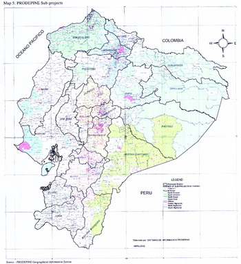
The development with identity project may be viewed as a paradigmatic example of neoliberal multiculturalism in the sense that, on the one hand, it promoted participatory methods to engender indigenous and black involvement in project design and decision making, while, on the other hand, it adopted tightly audited and technically defined terms of reference in order to specify which groups would receive resources.Footnote 44 As the first major development with identity project in Ecuador and the focus of international attention, the project's cartography responded both to indigenous imperatives to get assistance to the most needy, and to neoliberal criteria of successful social development targeting. Under the rubric of neoliberal governance, it was important to have a clear definition of potential beneficiaries and to know where beneficiaries were, in order to assist the project's management. As a consequence, CODENPE experienced a major re-scaling and reorganisation of its mapping skills, cartographic capacity and map production procedures in order to identify target populations, as the project was applied only in the parishes combining indigenous and/or black populations, poverty and local organisations. The project developed a detailed cross-referencing of spatial data combining indicators of concentrations of indigenous and black populations at the parish level from the census, levels of basic needs, poverty, and levels of social capital.Footnote 45 By this means, a total of 288 parishes, many of which contained interspersed multiethnic populations, were identified for intervention.Footnote 46 Indigenous project staff and funders invested considerable technical expertise and time in the creation of a geographical information system and a mapping process. Rather than just local-scale maps providing relevant information to project staff for project implementation, national-scale maps – with attendant symbolic and political meanings – were produced (Figure 1).Footnote 47
Map of PRODEPINE subprojects.

Cartographic information was central to the project's definition and operation, requiring new professional systems, personnel and procedures under CODENPE's aegis. These cartographics were co-produced with indigenous ways of understanding and using geography. Participatory mapping has been used since the early 1990s in Latin America to document indigenous landholdings, and has now become a widespread tool to involve populations in development programmes, demarcate land for title, and generally facilitate social policy.Footnote 48 Moreover, by bringing participatory and consultative mapping methods directly into the heart of the project, the institutional settings and procedures through which geographically-referenced information and knowledge was collated and represented were profoundly transformed. Whereas these inclusive methods were well established in indigenous movements, they were a radical departure from previous state mappings.Footnote 49 The audiences for these national maps were Ecuadorean publics, multilateral agencies and funders, as well as indigenous movements that could demonstrate shifting resource distribution patterns to grassroots populations.Footnote 50 With the production of maps conceived as a series of routinised practices, part of the state was reoriented (albeit incompletely) around the recognition of indigenous and black citizens.
Refining state inventories: Reworking the census through maps
Benedict Anderson reminds us of the close association between census and map, whereby the ‘crucial intersection between map and census’ arises as the national map delimits the territory and then the census demographically ‘fill[s] in politically the formal topography of the map’.Footnote 51 To the extent that the creation of inventories reproduces the long-recognised modern state impulse to knowledge-as-power, Ecuador had overseen various efforts to identify and locate ethnic populations long before neoliberal multiculturalism was introduced. Under mestizaje, ethnic populations were largely identified by linguistic criteria, again focusing on indigenous populations largely to the exclusion of other racialised groups.Footnote 52 These approaches were increasingly criticised by indigenous activists during the 1990s for their biased and inadequate data collection methods. Indigenous commentators pointed particularly to the state's use of proxy indicators – language, rural residence – as the basis for census counts rather than ethnic self-identification, and highlighted the serious ‘coverage problems regarding precisely the geographical areas where the nationalities and peoples are located’.Footnote 53
Partly in response to such critiques, and associated with the emergence of indigenous actors and policies within state structures and important non-governmental institutions, the methods of counting and mapping indigenous populations have shifted in recent years. The 2001 national census carried out by the Instituto Nacional de Estadísticas y Censos (National Statistics Institute, INEC) asked respondents, for the first time, questions about ethno-racial self-identity, resulting in official figures of 6.1 per cent indigenous in national totals.Footnote 54 Immediately after the census, sectors of the indigenous movement – the views of CODENPE and ECUARUNARI (Confederación Kichwa del Ecuador, Kichwa Confederation of Ecuador) are on record – led harsh criticisms of this state inventory exercise, demanding a more radical rethinking. In particular, these critics queried the coverage in indigenous (especially ‘remote’) regions, and census officials' relations with respondents.Footnote 55 Whereas the state has historically taken for granted its equal and impartial access through the entire national territory, building on modernity's common sense of abstract space, the critics worked from the premise that national spaces were highly diverse, including places not comparable each other because of the territorial and landscape heterogeneity, and their histories of state neglect and racialised geographies.Footnote 56 Taking their grievances to the UN, indigenous representatives argued that national statistics such as the census and household surveys ‘do not take into account the ethnic diversity of the country, [so] impede identification of the socioeconomic status of part of the population’.Footnote 57 Even when public institutions offered services, they did so without collecting information on users' ethnic identification. Moreover, the little data available on nationalities and pueblos was scattered across different outputs (academic, project-based, and others) and often not comparable across groups.
Indigenous activists and advocates strongly criticised state geographical/population information for being insufficiently intercultural.Footnote 58 Beyond this lay a spatial politics that highlighted how state knowledge of indigenous populations, although claiming a universal, totalising coverage, was in practice scattered, disparate and incomparable. In this sense, census practices directly reflect geographical imaginations that remain hampered by assumptions of national territory as a ‘space [that] stands still, fixed, unproduced’.Footnote 59 By contrast, indigenous critiques were based on a spatial politics founded on an understanding of the nation-state's partiality and power-saturated nature, and the difficulties associated with unexamined (and frequently unchallenged) geographical imaginations.
Such criticisms did not go unnoticed. After the perceived failure of the 2001 census, the question of identifying where indigenous and black populations were and in what numbers became politically expedient. With UN support, and continued indigenous activism, a specialist statistical service dedicated to documenting the numbers, distribution and characteristics of indigenous populations was created as a supplement to existing state statistical service units. Consequently, at CODENPE's behest, the Sistema de Indicadores de las Nacionalidades y Pueblos del Ecuador (System of Indicators of Nationalities and Peoples of Ecuador, SIDENPE), was established as an ‘instrument of statistical information that permits a visualisation of the life of the pueblos and nationalities according to their social, economic, environmental and cultural realities’.Footnote 60 Presented as the means to ensure state compliance with constitutional commitments to indigenous collective rights, this service was charged with improving the efficiency and completeness of state statistical coverage on ethnic populations. The argument for a specialist service was that the state failed to recognise
the pluralistic nature of Ecuadorean society as a transversal criterion that must guide not only the approach of the national statistical system in terms of content, but also in the organizational and logistical aspects of their undertakings, for which they should seek the indigenous peoples' involvement.Footnote 61
As we shall see, however, the wider spatial politics of state inventories and possible alternatives or reworkings of them remain inconceivable within the terms set by neoliberal multiculturalism.
SIDENPE was established within the state's Sistema Integrado de Indicadores Sociales (Statistical Service, SIISE) in 2002 with a low level of short-term funding, employing one indigenous statistician for three months, and funding two non-indigenous social scientists to carry out a survey of indigenous sacred sites.Footnote 62 In 2005, the system reopened with UNESCO support for four months before closing again, and then reopened in July 2006 with funding guaranteed to December 2007, to support one full-time staff member, at which time the SIDENPE staff member worked in the SIISE Quito office. As with development mapping discussed above, the SIDENPE infrastructure permits processes of state-endorsed and state-funded data collection on poorly documented groups, and symbolically acts as a public statement of multiethnic nationhood. The aim is to collect data and graphically represent information on collective rights, the extent of indigenous equality with national society, the internal processes of nationalities, and their capacity for self-management. For these reasons, ‘It is expected that [SIDENPE] will be a key instrument for the definition of public policies and their monitoring in favour of indigenous peoples.’Footnote 63
To overturn indigenous marginalisation from state data-collecting systems and indigenous organisations' limited capacity to generate such data, it became ‘imperative to redefine the concepts and categories and mechanisms for measuring the standard of living’ of indigenous populations, in order to contribute to ‘understanding values, interculturality, pluralism and to equal participation in Ecuador's development’.Footnote 64
In practical terms, the service was constrained by the parameters for measurement already established by the state. To generate the maps on the SIDENPE website and CD-ROM, the state social indicators system SIISE generates its own maps through an agreement with the Ministry of Agriculture's geographical information unit.Footnote 65 Combining geo-referenced data from the Ministry of Agriculture and INEC's cartographic data at the scale of city blocks, SIDENPE and its umbrella organisation SIISE are in a position to generate cartographic data independently of the Geographical Military Institute, which historically had a monopoly over the production and dissemination of national maps.Footnote 66 In this sense, cartographics have become relatively autonomous of long-standing centralised dominance over cartographic information.Footnote 67 Over the past few years, SIDENPE attempted to provide a more politically informed conception of indigenous presence, struggling to do so with limited resources and the legacies of state conceptions (and reproduction) of abstract geometries. Focusing on a ‘first phase system’, the service chose to work exclusively on rural geographies defined as rural parishes and the areas surrounding county towns.Footnote 68 Six levels of population density were identified, ranging from over 80 per cent of local population totals through to zero per cent. The indigenous development council acknowledged that, realistically, data would only be available for those areas with the highest share of indigenous people, namely over 80 per cent (level 1), and 60–79 per cent (level 2), and that the difficulty of mapping indigenous people in urban areas would need to be addressed urgently.Footnote 69
Despite these constraints, innovative maps of ethnic populations were generated. In 2002 the office managed to survey the nationalities and pueblos, giving them each a brief characterisation.Footnote 70 Recently SIDENPE carried out an indigenous rural household survey to address its core objectives of documenting progress in group rights enforcement and in refining and testing indigenous-specific variables and indicators for inclusion in the national statistical system.Footnote 71 By developing appropriate methodologies and surveying remote settlements, SIDENPE gathered data indicating more self-identified indigenous individuals than the census – 17–18 per cent compared with the census figure of 6.1 per cent.Footnote 72 With United Nations Population Fund support, it gathered information on demographics, maternal and infant health, lands and territory, education, inequality and poverty, health and reproductive health, housing, employment, and welfare, disaggregated by ethnic population, province and region.Footnote 73 In building up a picture of each ethnic group, SIDENPE also collected data on identity, traditional medicine, land, territories and biodiversity, social action, and territorial administration.Footnote 74 Indicators organised systematically by ethnicity demonstrate ongoing levels of inequality between indigenous populations and other groups.
SIDENPE represents an interesting shift in the ongoing rounds of neoliberal multiculturalism. By drawing on existing indigenous practices, it extends state cartographic procedures in innovative ways.Footnote 75 Unusual in mestizo, Cartesian geographical imaginations, SIDENPE gathered information on indigenous geographies and livelihoods. It thereby literally and symbolically puts indigenous people on the map. By this means, indigenous claims for resources, political representation, and service provision can be better leveraged against a state that has historically denied them.Footnote 76 Yet the material terms on which it can challenge the embedded politics of representation are less than favourable. SIDENPE's low budget and reliance upon other state (and indeed international) agencies for basic cartographic information reflect neoliberal budget cutbacks and ideologies of efficiency and subcontracting, compounded by governments' ongoing racialisation. SIDENPE renders state cartographies of indigenous populations problematic yet faces the huge task of unpacking the taken-for-granted power of a neutral, flat terrain whose image underpins state inventories, as if it were a question of adding another piece of data to a two-dimensional map.
National geographic: Establishing multiculturalism in schools
A poster produced as an educational tool offers another example of new cartographic processes. Emerging in the context of bilingual education and the multicultural reform of educational curricula, these maps speak to initiatives to provide a multicultural cartographic representation of national territory.Footnote 77 They challenge the static folkloric educational cartographies produced during mestizaje's high point, where indigenous populations were pictured alongside elements of their material culture (clothing, implements, cultural items) as discrete and ahistorical anomalies on a mestizo landscape.Footnote 78
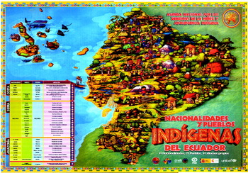
In the context of autonomous indigenous administration of bilingual schools, a poster made by an indigenous federation was designed to complement the political and physical national maps regularly available in classrooms.Footnote 79 Produced by the highland indigenous federation ECUARUNARI and taking its cue from the multicultural sign of diversity, the map was designed to convey pictorially the country's diversity in ‘cultural, geographical, socio-environmental’, terms, according to the map's editorial coordinator.Footnote 80 It was also conceived as a pedagogic tool, to be used by children and young people to discuss multiethnic diversity and ethno-cultural richness knowledgeably, ‘because the young people and children of one [ethnic] community didn't know other children of other nationalities and pueblos’ (Figure 2). With its use of childlike figures, bright colours, and unusually prominent pictures of housing, environments and physical features (mountains, rivers), this map offers a visual experience distinct from that of state-produced maps and of those discussed above.Footnote 82 The ECUARUNARI map includes a diverse array of indigenous populations across the entire national territory, interspersed with a variety of environmental regions and housing types. Inspired by a Mexican design – the Mexican Indigenist Institute and the Museum of Anthropology and History were mentioned as inspirations – ECUARUNARI prepared the map alongside a booklet about the multicultural agenda for children's and young peoples' rights.Footnote 83
Map of Ecuador, ‘Nacionalidades y Pueblos Indígenas del Ecuador’, produced by ECUARUNARI under the direction of Mario Bustos, 2007.

As in SIDENPE maps, the ECUARUNARI map used participatory and consultative methods to generate its core content rather than relying upon existing data sets or cartographic conventions, which were dismissed as incorrect or incomplete. First, the ECUARUNARI team worked from photos and information on ethnic groups' customs and dress, taking care to collect information on ‘cultural and symbolic geographic environments’. Then, in small workshops around the country, children and teachers identified the errors or gaps in previous publications. As such, the children's map is an example of a mapa parlante in that ‘the map on its own offers knowledge’.Footnote 84 Workshop responses were recorded on video and in photos. Finally, a national-level workshop with teachers and ‘people who know culture’ was held to validate the materials collected in the fieldwork, to make final corrections, and to ensure that core elements met each indigenous group's criteria.Footnote 85 In six months the ECUARUNARI team gathered the necessary information and from early 2007 it took the illustrators five to six months to complete the drawings and layout. Overall, a team of between six and ten illustrators and digital design experts, most of them indigenous, were working at any one time on designing, illustrating and mounting the map, making constant comparisons between the emerging illustrations and field material. The final map was relatively small in size (99 cm×60 cm).
As ‘the majority of ordinary maps don't locate populations’ identities', the map responds to the multicultural imperative to recognise and represent diversity. The map represents everyday life through the depiction of typical activities and the ethnic groups' dress and appearance. As the expression of a geographical imagination, the map shows the spatialisation of social life, making visible the ways that social life literally ‘takes place’, and articulating national terrains with livelihoods that tend to be problematised by development policies, or metaphorically flattened by census procedures.Footnote 86 According to the editorial coordinator, ‘We are valuing the process of recuperating traditional dress, so that it becomes part of their everyday clothing.’Footnote 87
To the extent that national identities can become banal and taken for granted over time, so too the aim was to make ethnic livelihoods and identities an integral part of young people's general knowledge. Through the use of the map in classrooms, its wider references and meanings reinforce the belief that ‘this cultural fact [indigenous lives] is being lived through in the map’.Footnote 88 Consciously showing dynamic ethnic cultures, the mapmakers demonstrated how indigenous people move around the country changing customs and food (e.g. Kichwa in the Galápagos), upturning mestizo expectations of self-contained and immobile indigenous groups. Viewed as a response to the need for a multicultural policy on young people, ECUARUNARI's map tackles the representational and informational difficulties of cartography in a different way to the development policy and SIDENPE examples, while still using participatory methods. Its focus on children and their lives offers a distinct spatialisation, challenging the types of map that aspire to universal status.
Multiculturalism has brought participatory and consultative mapping practices into the heart of three key arenas for geographical representation namely development, census, and education. This section showed how indigenous populations are shown in multicultural maps, and how maps are being produced within core state activities with the attendant lack of resources, authority, and scope for innovation entailed by neoliberalism. In each case, the coincidence of neoliberalism with multiculturalism materially constrains the scope and nature of cartographies, while a lack of indigenous leverage over resources and public authority reduces their maps' impacts. Nevertheless, to an extent perhaps unprecedented elsewhere in Latin America, the ways that indigenous organisations and communities create and use maps have been brought partially into national cartographic productions. Through the practices undertaken in indigenous-staffed state agencies and knowledge and skills gained from previous rights activism, ‘the racialised themselves are indianising Ecuadorean geography’.Footnote 89 CODENPE's role as a clearing-house and institutional support for these national maps' production cannot be denied, yet its cartographic activities remain too often ‘mired in … painstaking, technical, administrative and highly inequitable negotiations for resources and political power’.Footnote 90 It is to this wider context of mapmaking that we now turn.
Beyond the Multicultural Map: The (Dis)contents of Multicultural Cartography
As nation-states' cultural productions, maps reflect the meanings and suppressions of the society making them. The geographer Brian Harley argues that any cartographic representation is inherently associated with exclusions, suppressions, and selective presentation of what is there due not only to the very nature of the cartographic form, but also the inbuilt dominant forms of viewing that ‘frame’ a map.Footnote 91 Informed by his concern to link maps to the power relations producing them, Harley's deconstructive project is here brought to bear on the Ecuadorean national maps introduced above, focusing on what they leave unmapped, outside the image, and why. The focus switches from neoliberalism per se, towards underlying racial hierarchies and cultural difference. Four themes are examined: the invisibility of whiteness and mestizaje; the dynamism of ethnic identities; differentiation among indigenous populations; and the forms of geographical knowledge that go into national maps.
Although multicultural maps attempt to represent pluricultural society, they are extremely selective in terms of the ethnic populations shown on national maps. Whereas Ecuador proclaims itself to be a pluriethnic, multicultural society, its new national maps could lead one to understand that to mean diverse indigenous populations. Afro-Ecuadorean populations are only partially included, and the socio-economic and cultural diversity of mestizo groups largely unrecorded. In Ecuador the whitening impulse behind the processes of mestizaje privileges white and mestizo populations, making them an unmarked category in racial hierarchies. Assumed to be present throughout (the ‘important’ parts of) national territory, whites/mestizos need not be mapped, as their power to be everywhere is already taken as read, a fact that anticipates and frames the map's production and then its interpretation. Representationally, the capacity of whiteness/mestizaje to remain unmarked yet hegemonic in mapmaking focuses attention on what is outside the map, namely the specific terms of state-led multiculturalism's existence.Footnote 92 Reflecting and reproducing the centrality of whiteness and its socio-cultural dominance, multicultural ‘cartography deploys its vocabulary accordingly so that it embodies a systematic social inequality’.Footnote 93 Despite the state's production of maps of indigenous people, the dominant mestizo gaze ‘organises, normalises and controls the ethnoracial and spatial geography of the territory and national image’.Footnote 94
In a discussion of press images, Andrea Pequeño rightly argues that if mestizo and white Ecuadoreans are not mapped onto any one part of the country, it implies their freedom of movement and claim over the entire territory.Footnote 95 Indigenous plurinational projects aspire to gain this metaphorical freedom for ethnic populations, as illustrated by the ECUARUNARI map. From the perspective of its producers, the ECUARUNARI map was conceived as of national importance for ‘the generality of the country, … [even] the international level’.Footnote 96 Yet in the end the map's few copies were distributed only to bilingual schools and a few ‘specialist’ agencies, and its potentially universal relevance was undercut by a combination of neoliberal budget pressures and lack of political will. Consequently, it failed to reach the status of a racially unmarked cultural artefact. Yet one can go further. Pequeño's argument rests within the map, and thereby misrecognises how the very representational terms of Euclidean geometry and the abstraction of state-power-as-territory set the context within which such maps are produced as well as read. In this sense, the ECUARUNARI map fitted a multicultural ‘slot’ permitted to ethnic populations within a ‘simplified frame’. This positioning ‘emerges through a particular pattern of engagement and struggle’.Footnote 97 Since whiteness and mestizaje are not mapped – and thereby not pinned down to one spot – other groups find themselves in a multicultural slot and a national cartographic frame in which ethnic governable spaces are shown as fragmented, embodied and picturesque, rather than as universal, abstract and mainstream.Footnote 98 To counter the cartographic consequences of this racialised logic, indigenous mapmakers attempt more critical representational strategies such as refusing to folklorise ethnic groups.Footnote 99
The normalising gaze treats ethnic Others as secondary and outside the mainstream, a form of social dominance that remains unremarked on the map yet reinforces the incorporation of mapmaking into dominant ways of seeing, as noted by the ECUARUNARI map's coordinator:
We [like to] continue to think about the country [being] in the intercultural processes. [But] in the state, in the non-indigenous part of the population, there are no real efforts to live interculturally, to know others, to get to know them. So we [try to] generate respect for other peoples' cultures … For example now we are getting ready for the Constituent [assembly in 2007]. So, yes, we have citizenship rights for everyone, but as indigenous peoples we have collective rights, cultural and political rights as peoples. And we must claim [reivindicar] these rights as indigenous peoples.Footnote 100
In this sense, the ECUARUNARI map articulates an anticipatory cartography rather than the achievement of intercultural respect.Footnote 101
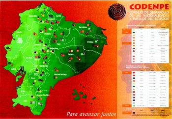
Multicultural maps also struggle to capture the processes of cultural re-signification occurring in ‘pueblo reconstruction’, a process that often exceeds the capacity of mapmakers to picture dynamic indigenous identities. During the 1990s, ethno-cultural groups explored place-specific customs, practices and histories in order to challenge mestizaje and to diversify the indigenous category, a process that expanded the number of nationalities and pueblos (hence reconstruction). Consequently, mapmakers face the task of following and mapping these processes. Tracked over time through the 2000s, CODENPE's and its sub-agencies' maps demonstrate a steady rise in the numbers and locations of distinct ethnic nationalities and pueblos. For instance, the 2003 map ‘CODENPE Para avanzar juntos’ lists 13 nationalities and 13 Kichwa pueblos and the ‘Manta-Wancavelica-Puna’ pueblo (Figure 3).Footnote 102 By contrast, by 2007, the ECUARUNARI map (Figure 2) lists 14 nationalities, 20 indigenous pueblos and 14 distinct languages.
Map of Ecuador ‘Para avanzar juntos’, produced by CODENPE, 2003.

In the production and circulation of these maps, public culture is exposed to information about the dynamic and expanding process of ethnic presence. SIDENPE's regular on-the-ground population surveys, combined with its close connection to the indigenous movement, means that it is in the position of being able to collect information on emergent ethnic identities and organise such data spatially, responding rapidly to the emergence of reconstituted ethnic groups.Footnote 103 Whereas in nineteenth-century Mexico, state cartographers struggled with what Raymond Craib terms ‘fugitive landscapes’ (that is, landscapes with inconsistent topographic names, unavailable baseline maps, and confusing land histories), multicultural mapmakers in twenty-first-century Ecuador are dealing with the fact that ethnic identity cartographies are part of an ongoing process, rather than a fixed category.Footnote 104 Whereas the Mexican state was undermined by its fugitive landscapes, Ecuadorean multicultural mapmakers face the challenge of documenting and representing landscapes-in-formation.
Other cartographic tactics challenge dominant interpretations of ethnic positionality by pointing up the variability of indigenous populations, thereby challenging the associations of ethnicity with rural areas, and with the symbolic power of female figures, as well as pinpointing the geographies of indigenous poverty. A widespread trope in Ecuador, as elsewhere in Latin America, is the association between essentialised ethnic identities and women, due to their distinctive clothing, rural activities and monolingualism.Footnote 105 Rejecting the identification of ethnicity with femininity, however, the ECUARUNARI map pictures indigenous identity as male and female (Figure 3). As a deliberate choice, each ethnic group is represented by a boy and a girl:
We have organised [the map] so that they [indigenous boys and girls] are in pairs, to convey a sense of gender difference, and also we pick up the practices and cultural traditions of the peoples and nationalities as well as visualising the geographical contexts in which they develop.Footnote 106
Moreover, by representing couples, this map (whether intentionally or not remains unclear) resonates with the discourse of female–male complementarity, a symbolic connection to indigenous claims to difference which remains unrepresented on other maps.Footnote 107
Additionally, cartographies are a powerful symbolic language to highlight the insecurity of indigenous livelihoods and address the differentiated impacts of political economic restructuring. In the words of Luis Maldonado, former CODENPE executive secretary: ‘Obviously, if you cross the ethnic map and the poverty map, you find that they coincide; they are the same map. And this shows you the level of exclusion that exists.’Footnote 108
Finally, despite increasing activism around the issue of indigenous urbanisation, national-scale multicultural maps have not yet represented an increasingly diverse urban indigenous presence.Footnote 109 The reduction of SIDENPE's range to only rural areas reflected the lack of staff and resources under neoliberalism rather than a truly national coverage.Footnote 110 Although aiming to map rural and urban self-identified indigenous populations, SIDENPE struggled to collate the disparate and incommensurable data into politically significant cartographies.
As geographer Brian Harley has shown, cartographic rules are not neutral but derive their standards from a specific European scientific epistemology in which cartographic conventions are believed to be value-free and only ‘Other’ mapmaking represents bias.Footnote 111 In Ecuador the normalisation – and scientific status – of mapmaking and geographical information through the state's use of international conventions and national routines of rule tends to delegitimise indigenous practices vis-à-vis other practices.Footnote 112 As noted, SIDENPE uses maps from the Ministry of Agriculture's geographical information service as the basis for its own maps. Since its establishment, the Ministry of Agriculture has been concerned with evaluating and acquiring cartography and digital computer and imaging hardware and software defined in highly technical terms.Footnote 113 In this context, ministry professionals normalise the value of systematic geo-referenced data and scientific techniques over other processes of generating maps. According to the Ministry's director for Geographical Information Systems (GIS):
Other people use a ‘mapa parlante’, but this is biased. By contrast, [the GIS unit] uses international norms to correct its data. A talking map [mapa parlante] is very rich, but it has a lot of bias too. So, for example, you have the people's viewpoint in the map. As [our work] is a very serious piece of research, we try to apply a rigorous process and we work with norms. We have international standards [normas] that are already given in the international catalogue, and to which we have to adapt. The other condition is that we have to work only with valid documents.Footnote 114
Delegitimising participatory mapping techniques and inclusive cartographic methods by identifying them as unscientific closes off any discussion of how cartographic practices can be diversified and their power effects critically examined.
Yet in other arenas of Ecuadorean state activity, participatory methods of mapping are used to generate geographical information that is then used to build up national – not just local – maps. Rather than rely on the computer-based GIS, SIDENPE surveyors talk to what staff call ‘qualified respondents’, most of them indigenous locals, to gather information about ethnic groups' location, identity and specificities, settlement by settlement. Without romanticising this knowledge (it remains highly differentiated due to communal hierarchies of gender, education and class), it can be argued that these methods generate innovative types of information embedded in a politics of participation. According to CODENPE, this method of data-generation ‘places emphasis on the participation of nationalities and peoples, and regional and national organisations, in defining themes, formulating methods and devising strategies for incorporating information’.Footnote 115
Such socio-spatial data relies upon knowledge-gathering methods unused by previous state officials, reflecting a distinctive understanding of the relationships between people, place and positionality.Footnote 116 Placing cartographic and geographical information firmly within a wider information-gathering and awareness-raising method, these participatory methods grant authority to non-geographers and non-surveyors in ways that challenge the association between professional status, neutral knowledge and the resultant maps.Footnote 117 Rejecting the ‘view from nowhere’ of Cartesian mapmakers, these methods generate sets of knowledge from individuals and populations who have an everyday, embodied connection to the areas they describe.
From Maps to Postcolonial Geographies: Spatial Metaphors and Criticism
To contextualise further the power dimensions of mapping and statecraft, this section analyses how a critical account of state-sponsored multiculturalism can be advanced. Specifically, I argue that analysts need to be attuned to the way that their accounts of indigenous contestation of state policies conceptualise and represent space within and beyond the map. Critical accounts of Latin American exclusionary political cultures often draw on spatial metaphors (a geographical lexicon from social theory for description and analysis) to bring home the force of their argument.Footnote 118 For example, authors have argued that state-led multiculturalism creates ‘political spaces that have been opened’, into which ethnic concerns are ‘propelled centre-stage’, resulting in ‘vertical [indigenous–state] relations of subordination and violence’ becoming ‘horizontal arrangements’.Footnote 119 Charles Hale's critique of neoliberal multiculturalism is indicative of the force of spatial metaphors. Guatemalan multicultural legislation opens up ‘new spaces’ and ‘arenas of political contention’ for indigenous populations, albeit always within ‘clearly articulated limits’.Footnote 120 Such metaphors highlight the geographies of connection and power that shape multiculturalism across the multiple scales of the nation-state, international agencies, subnational elites, and international anti-neoliberal activism.Footnote 121 Yet these metaphors can result in what geographer Matt Sparke terms ‘anaemic geographies’ of analysis.Footnote 122 Alternative conceptions of space as socially produced and irredeemably contested offer alternative insights into multiethnic cartographies.
The Ecuadorean state continues to produce ‘official’ cartographies alongside its maps of ethnic diversity; these are largely produced by the military, reinstating continuously the state's claims to territorial sovereignty and existence. Such maps take for granted and re-state the nation-state's abstract space.Footnote 123 Abstract space – the notion that the territory within international borders exists as a singular, self-evident space – arose out the conquest and colonisation of indigenous-held territories. Such conquest was often premised upon the concept of empty lands (terra nullius). Cartesian logics and conventions thereby reinforce the association of statehood with sovereignty and assumptions of a tabula rasa for states and their maps.Footnote 124 As such, the dispossession of indigenous populations remains an unacknowledged underpinning to state cartography. Moreover, the present-day reality for many indigenous and black populations is to be dispersed across a series of overlapping, fragmented and often insecurely titled lands, geographies that disempower ethnic groups and restrict their access to resources. State awards of mining and petroleum concessions to companies disrupt indigenous territories, undercutting meaningful livelihood possibilities. Under Ecuadorean law, state claims to natural resources and ownership trump ethnic autonomy in protected biodiverse areas, thereby reasserting state sovereignty and undermining ethnic autonomy. And all of this is represented in cartographic conventions that restate through their very form Cartesian notions of order and hierarchy.
Returning to the spatial metaphors used by analyses of Latin American state-sponsored multiculturalism, it can now be argued that their anaemic geographies can be supplemented by postcolonial accounts of the historically specific co-production of space and society in pluricultural nations. To see national maps as tools in, and reflections of, a struggle over abstract space is important. But to understand the connection between (post)colonial dispossession and its cartographic assumptions draws upon broader concepts of space as socially produced through power relations. Only this history of state cartography could result in an offer of territorial autonomy to indigenous and black populations. Yet of course space is inherently contested, as revealed by the diverse spatial strategies adopted by indigenous people in their struggles for rights and demands for collective territories.Footnote 125 As noted above, indigenous cartographies reflect diverse conceptions of space that affirm indigenous presence, articulate hopes for plurinational futures, and disrupt colonial notions of terra nullius. Overall, however, while the nation-state partially concedes the cartographic representation of ethnic diversity, its underlying conception of an abstract space remains in force. In other words, indigenous claims to cartographic representation exist in the context of legislated material exclusion of indigenous claims to national territory. Until legacies of dispossession are acknowledged and a more inclusive notion of space emerges, an inclusive plurinational programme remains unfulfilled. Forcing such changes would rely upon a profound reorganisation of the validation of knowledge and a sustained postcolonial politics.
Conclusions
Maps matter. Although apparently less contentious than ethnic autonomy, education or linguistic policy, this paper argues that cartography speaks to core practices of governance, identity production and power across the nation-state, and the contested meaningful ways it attends to subaltern struggles for rights. Cartography and geographical data are, moreover, one of the key arenas through which nations represent themselves as a coherent and sovereign meaningful place, and the means by which state projects are organised and rationalised. Focusing on the relationship between cartographic representation and nation-state formations, this paper has analysed the ways that an indigenous presence is represented by Ecuador's neoliberal multicultural nation-state. Examining map-making processes provides an invaluable insight into the nitty-gritty of multiculturalism in practice.
The paper demonstrates how across state cartographic practices, the specific state formation of Ecuador is reoriented towards state-led multiculturalism in ways that are informed by its colonial and republican racial hierarchies, although its organisational, representational and interpretative work around national maps of ethnic diversity appears at first sight to have been radically transformed. Ethnic participatory mapping attuned to indigenous populations' socio-spatial characteristics represents a significant shift, although limited epistemologically and logistically. However, the lack of political interrogation of cartographic production, reception and conventions means that indigenous activists continue to face challenges in developing a post-multicultural cartography in which colonial dispossession, the politics of intercultural respect, and indigenous territories would be recorded and recognised. Without the political authority to challenge the hegemonic ubiquity of whiteness on the one hand and the folkloric containment of indigenous populations on the other, mapmakers are left standing without the means to map out racism.
The extent to which the 2008 Constitution's adoption of principles of interculturalism and post-neoliberalism changes the context for subaltern rights struggles remains to be seen. While the Constitution established a stronger legislative basis for recognition of ethnic territories and pledged a commitment to social equality, President Correa has expressed antagonism towards indigenous organisations. Debates around regionalisation and devolution of government represent other strands in the state's dynamic spatial reorganisation, which will inevitably shift cartography's purpose and content. It remains to be seen whether indigenous peoples and their representatives can rework the ‘slot’ awarded to them by existing racial hierarchies. If postcolonial criticism constantly prompts us to make connections between current patterns of racial hierarchy and material dispossession, it also provides tools by which to question colonialism and its aftermaths. Colonialism dispossessed peoples by ‘othering’ them, and by assuming that empty lands were passively there for the taking and Europeans could write History over them. By failing to face up to its dominant geographical imaginations and spatialisations, today's state multicultural projects risk making mere marks on a page. Multiculturalism is on the map, but the broader systematic critique offered by this paper comprises one strand in actions required to tackle racial hierarchies and prevailing politics of knowledge in and outside the map.