The provisioning of city dwellers depends on agricultural supply chains to transport foodstuff into the city, and urban provisioning institutions to facilitate their distribution to residents. Urban growth in particular requires that both ends of the provisioning system function properly to satisfy rising demand. It is hardly an overstatement that access to adequate quantity and quality of food supplies is a vital concern for any city. And whereas managing agricultural resources normally falls outside the jurisdiction of municipal governments, the question of distribution is largely a matter of urban policy. How cities regulate, manage and oversee their provisioning infrastructure is a central problem for urban history.
This article contributes to the historical literature on urban provisioning at two levels.Footnote 1 As a case-study, it reconstructs the development of New York City's food retail infrastructure over the first half of the nineteenth century from a tightly controlled system of public markets to an unregulated free market economy. At the theoretical level, it examines how different regulatory and institutional structures shape the locational patterns of food distribution, in effect, defining residents’ access to provisions. Further, it outlines the underlying spatial principles of the municipal market system, which served as the dominant infrastructure of food access in American cities until the last decades of the antebellum period.Footnote 2
Two issues anchor the analysis. The first concerns political economy, specifically the role of city governments to regulate, manage and monitor urban food markets on behalf of the common good. Should citizens’ access to food be regarded as a public good, to be sustained by active and direct government involvement, or, conversely, should it be treated as a private matter, to be satisfied by free markets? American cities stood firmly on the public side of this debate, and thus managed tightly controlled municipal marketplaces to ensure the proper provisioning of residents. Public markets served as privileged sites of food retail, where fair trade practices and basic standards of food quality could be enforced.Footnote 3 This model, however, did not survive the antebellum era, America's take-off period of urbanization. From around the 1840s, cities increasingly liberalized their retail food markets, pushing urban provisioning to the private domain.
The second issue concerns space, in particular the geography of food retail. Importantly, the analysis treats access to food as a spatial problem because residents commuted to their local marketplace daily to buy necessities. In the context of urbanization, the food retail infrastructure had to expand at the pace of population and spatial growth, a central question for the analysis. Yet this problem also has larger theoretical relevance for the relationship between political economy and geography. Specifically, how did different institutional models of retail food distribution respond to the pressure of urbanization? More broadly, did the distinct political economies of public market versus free market based provisioning generate different retail geographies? Finally, did the public market system develop along generalizable spatial principles?
New York City offers an ideal case to explore these questions. First, as America's largest and fastest-growing city, whose population increased from 30,000 to 800,000 between 1790 and 1860, its provisioning infrastructure felt the weight of urbanization especially intensely.Footnote 4 Second, Gotham's municipal market system was the best developed in the nation, while its deregulation in 1843 fuelled the most heated public debates.Footnote 5 Like elsewhere, the foundation of the city's public market model was the legislative restriction that limited the retail of butcher's meat (fresh beef, veal, lamb and mutton and pork) to licensed butchers working at municipal marketplaces.Footnote 6 While it may seem a trivial restriction, this crucial clause of the market laws had far-reaching consequences for the geography and practice of food retail. Given the central role of butcher's meat in the American urban diet, the tightly controlled meat trade agglomerated the sale of most food supplies in and around the public markets.Footnote 7 Conversely, the decision in 1843 to deregulate the butcher's trade, in essence allowing anyone to open a private meat shop anywhere in the city, contributed to the general decline of the public market system. In principle, the market laws’ requirements of fair trade practices and food quality were extended to shop butchers. In practice, the instant proliferation of private shops, without any complementary effort to augment the city's policing power to enforce the laws, meant that by the mid-nineteenth century the retail of meat and other food supplies by and large escaped government oversight. The analysis therefore pays special attention to the retail meat trade, which served as the cornerstone of the municipal model, and was the most affected by its deregulation, while it also generated a wealth of sources.Footnote 8
The article develops in three sections. First, it presents a theoretical discussion of the locational principles of urban food retail, extending these insights to the public market system. Second, it traces quantitatively the development of New York City's food retail infrastructure, in particular the transition from public to private retail meat markets. Third, it uses GIS mapping to explore the market system's geographic expansion relative to urban growth, and compares this to the spatial patterns of unregulated retail. Overall, the article examines New York as a case-study in its own right, and a platform to study larger issues about the relationship between political economy, retail geography and residents’ access to provisions in the context of urban growth.
Theoretical considerations
In addressing these issues, central-place theory provides a useful analytical framework.Footnote 9 Food retailers sell what are considered par excellence convenience goods: relatively cheap goods, bought frequently, in the case of fresh food, maybe as often as every single day. They are the opposite of so-called shopping or comparison goods: more expensive products, bought only occasionally. To understand the locational patterns of different types of market activities, central-place theory postulates their varying levels of centrality by two countervailing variables. The first one is the economic reach of a given product, also called range, which refers to the maximum distance consumers are willing to travel to buy that good. The second is the conditions of entry, or threshold requirements for a product, describing the minimum demand needed to keep a certain type of business profitable.Footnote 10 Given their different levels of centrality, certain businesses provide goods for the entire city, while others cater only to specific communities, neighbourhoods or customers within a few blocks radius.Footnote 11 At the same time, basic needs have to be met in all areas, while higher order demands will be serviced at selective locations.
From these points, some key locational patterns about food vendors may be derived. First, one would expect a relatively large number of food retailers compared to other types of businesses in any city given their low threshold. Second, food vendors are expected to disperse for they need to move near their customers: how close largely depends on the means of daily commute, which in a dense urban area usually falls within the range of a convenient walk. Third, food vendors of the same goods seek out mutually exclusive market areas to minimize competition, and thus are likely to disperse evenly: how far from their nearest competitors depends on their threshold demand, a function of residential density and population characteristics.Footnote 12 Fourth, food vendors of different goods, selling complements not substitutes, may cluster close to each other for they benefit from scale economies in shopping externalities. Finally, beyond a certain size, urban food markets will generate institutions of higher centrality: public markets serve residents from an entire neighbourhood, while wholesale markets service food vendors from across the city.
Back to early nineteenth-century New York: the centrepiece of the theory concerns the means and frequency of shopping. On these two accounts, the case is simple for food provisioning was done exclusively on foot, and because of concerns about food preservation before refrigerators, households had to procure provisions frequently, about three to four times per week.Footnote 13 New York was also a densely populated city, and thus it generated the necessary threshold demand for butcher's meat and other provisions across its urbanized area.
On a third point, however, New York behaved very differently from what the theory describes, but this is precisely what makes the case interesting. A key assumption of the model is that retailers operate in a free market environment, unrestricted in their locational choices, with the only mechanism of spatial sorting being supply and demand. The public market system, however, presented an alternative political economy, whereby butchers were allowed to sell their goods only at individually assigned stalls at public markets, which limitation, in turn, concentrated the retail of most of fresh foodstuff into these privileged locations. The underlying logic was agglomeration economies derived from shopping externalities. Since customers had to visit their local marketplace to purchase meat, it made sense to buy all other provisions during the same trip.
Through this simple regulatory framework, the Common Council, New York City's legislative body, played a dominant role in shaping the geography of provisioning. Instead of leaving it to market co-ordination to govern the locational patterns of retailers, the municipal model brought the process into the political arena, putting city officials in charge of negotiating between the interests of local residents and food vendors on behalf of the common good. The corresponding geography then was not only subject to different spatial sorting, but, in principle, reflected public priorities to ensure that all residents had access to adequate quantity and quality of food supplies. Additionally, the decision to repeal the market laws’ key clause regarding the sale of butcher's meat in 1843 meant that supply and demand were now granted full force to redraw the provisioning landscape, much along the assumptions of the theory.
Aside differences in free market versus political co-ordination, central-place theory remains applicable to predict the municipal model's optimal geography. A well-designed market system has to offer convenient access to residents in all areas. Accordingly, public markets are also expected to be evenly distributed, with distances between them being defined by the radius of a manageable walk. The number of locations depends on this range and the city's built-up area. Clearly, marketplaces will be fewer and stand farther apart than independent shops would in an unregulated environment. If meat shops serve customers from a few blocks radius, public markets will be par excellence neighbourhood retail centres. On their part, marketplaces offer the flexibility to respond to uneven residential density by adjusting their scale, construction and number of vendors. Overall, for the municipal model to be effective, it had to balance the competing principles of dispersal and agglomeration. Marketplaces had to be opened across the city, while at the same time their capacity at the individual locations had to be adjusted to satisfy their catchment areas’ demand.
One additional factor to account for is that Manhattan is a long and narrow island, with a clear north to south orientation, situated at the confluence of the Hudson and the East Rivers. For a mercantile city, access to water was the most vital transportation link and economic resource, and thus commercial activities concentrated near the rivers. A well-functioning public market system also had to be anchored near the riverfronts to take advantage of transportation connections to supply hinterlands.
Until now, the key issue of urban growth has been largely absent from the discussion. From the viewpoint of central-place theory, the expansion of retail activity is a direct outcome of urbanization.Footnote 14 As the city grows into hitherto un-urbanized areas, food purveyors are expected to follow once threshold demand is met. Similarly, as older areas become more densely settled, new businesses are to appear to claim their share of a growing provisioning market. In spatial terms, then, urban growth is accommodated by the addition of new business locations and their denser spacing. Food retailers will be fewer and farther apart in the lightly settled urban frontier than in densely populated central districts.
The public market model presents a more complicated case. First, the circumstance that the system's expansion requires the approval of municipal officials in response to petitions by concerned citizens introduces some conditionality to the process.Footnote 15 Second, marketplaces are institutions of higher centrality, for even the smaller ones are attended by several independent vendors, including butchers, fishmongers and sellers of fruits, vegetables and other goods. Correspondingly, their threshold demand is considerably higher, and the system's growth occurs in larger steps. One concern is that under the pressure of urbanization, some time lag may occur between the settling of frontier areas and the extension of market facilities. If so, local residents would find their daily provisioning trips too taxing, at least until infrastructural growth catches up. Alternatively, the decision to extend market facilities into frontier areas may precede the presence of threshold demand, in effect, anticipating urban growth. This outcome should pose little problem, for population growth would follow rapidly, in part, thanks to the anchoring role of the marketplace in attracting new residents.Footnote 16 Overall, given the mediated process of infrastructural growth and the agglomerated economy of the marketplace, both the expansion of the market system and the allocation of individual facilities relative to residential density and frontier development are key issues.
Urban growth and retail expansion
The theoretical considerations outlined above offer a useful framework by which to assess the development and geography of food retail in New York during the city's first era of modern urbanization. Additionally, they allow for comparing the spatial logic of two distinct political economies of provisioning, as access to food shifted from the public to the private domain in the antebellum decades. The analysis proceeds in two steps: this section outlines the chronology of the food retail system's development relative to population growth, while the next one explores how its geography responded to shifting residential densities and northward expansion.
Addressing the first issue, it is important to document the development of the city's provision business, specifically to what degree the addition of new retail capacity kept pace with urbanization. Until 1843, the process had to be largely limited to the public market system, with city officials endorsing the construction of new market buildings in frontier areas, while also allocating public funds to enlarge existing facilities in older, densely settled central districts. The number of public markets is an imprecise measure for it fails to account for the widely different scale of the individual locations. Instead, the best way to measure industry growth is to count the number of butcher stalls across all public markets.Footnote 17 After deregulation, both market and shop butchers are considered.Footnote 18
Figure 1 presents four indicators in a time series: first, it plots the number of butcher stalls at the public markets between 1790 and 1860; second, the number of residents for each stall in the same period; third, the number of private meat shops that opened between 1842 and 1854 following deregulation; and fourth, the number of residents that an average meat retail outlet, market stalls and meat shops combined, supplied. The data offer an unprecedented opportunity to study the development of food provisioning in America's largest and fastest growing city. But before, one caveat regarding the measure of consumers per meat retail outlet should follow.
Butcher stalls and meat shops (1790–1860)

The rationale for this indicator is to establish what may be considered the threshold population for the butcher's trade. The expectation is that this ratio changed little during the period. In theory, individual butchers may have increased their volume of sales to meet rising demand from a booming population. Yet they faced certain structural constraints, which limited the scale of their operations. First, as already noted, food provisioning was a household chore to be conducted by walking, and in one's neighbourhood. Butchers thus relied on residents living within walking distance, which confined their pool of customers. Second, the lack of modern refrigeration, both for butchers and households, limited the scale of individual transactions.Footnote 19 Customers would only buy as much fresh meat as they expected to consume within the next few days, and in turn, retail butchers would cut up only as much meat as they expected to sell on any business day. Lastly, market butchers worked out of stalls, whose modest size was prescribed by legal statutes, precisely to curtail competition. Retail meat shops were similarly small-scale operations, even if the Council had no control over their layout, because of the first two reasons.
Turning to Figure 1, the data outline three periods in the development of the provisions trade: from the 1790s until the early 1820s, the expansion of the public market system matched almost perfectly the growth of the population; from the mid-1820s until deregulation in the early 1840s, the Council continued to enlarge its infrastructure, yet investments failed to keep up with accelerating urban growth; last, from deregulation through the 1850s, the public market system fell behind not only in relative terms, but also shrank in absolute size, rapidly losing ground to the now bourgeoning private food retail sector.
A closer reading of the data allows for a more careful reconstruction of the chronology. In the first period, the number of butcher stalls increased steadily, from 75 in 1790 to 223 in 1820. Despite the city's robust, nearly fourfold population gain, the threefold expansion of the provisioning system ensured that the number of consumers per stall grew only modestly: from around 430 in the 1790s to just below 500 in the first two decades of the nineteenth century. Accordingly, the average butcher in the 1810s served a clientele only about 15 per cent larger than his fellow craftsman one generation earlier. Surely, some butchers may have improved the efficiency and scale of their businesses, but this must have occurred only by narrow margins. Instead, industry growth was driven by the entry of new butchers, which in turn required the Council's uninterrupted investments into its market system: a testimony of the Early Republican consensus of access to food as a public good.
The second period was characterized by a hesitant departure from this social pact. On the one hand, the number of butcher stalls continued to increase, peaking at 407 by 1840. On the other, infrastructure growth at this rate was inadequate to match accelerating urbanization. The number of consumers per stall gradually and persistently rose, passing the 500 threshold by the 1820s, to reach 848 by 1842, the year before deregulation. Despite the Council's efforts to open new public markets and enlarge older ones, its investments lagged behind the demand of an emerging metropolis. Some butchers may have increased their volume of sales marginally, but this could not compensate for the pressing lack of retail capacity in the system. Not surprisingly, as numerous documents reveal, unlicensed vendors soon stepped in, occupying the economic niches and underserved spaces left open by public market facilities.Footnote 20 By a rough estimate, the share of this informal economy reached about 20–5 per cent of the city's retail meat trade in the 1830s.Footnote 21 Overall, New York City's one-and-half-century-old public market system began to show weaknesses, as the daily practice and institutional structure of food retail started to divorce from each other.
The liberalization of the sale of butcher's meat officially did away with the municipal model of provisioning. The Common Council abandoned its historic commitment to public markets, leaving it largely to private initiative to satisfy the growing appetite of the Atlantic world's now third largest city. With no new public markets built from 1837, a few smaller ones shut down in the 1840s, and most others left to decay, the number of butcher stalls fell consistently to 320 by the late 1850s. Meanwhile, private butcher shops proliferated: between 1842 and 1854, their number grew exponentially from a little over 320 to close to 1,000. The instant opening of hundreds of meat shops is strong evidence that many butchers, formerly left without market stalls, had for years sold fresh meat informally. Now they could admit to city directory surveyors their shop address, and register their businesses. Most tellingly, the number of residents per meat retail outlet, market butchers and meat shops combined, reverted to the same threshold figure of around 500 residents like in the 1810s. Overall, the evidence is clear that by the mid-nineteenth century an unregulated and fragmented free market retail environment emerged, where households procured provisions at public markets, private meat shops and groceries, as well as street vendors.
Geography of food retail
Urban growth, the expansion of the provisioning system and the distribution of food retailers relative to the population are spatial questions. Having outlined the chronology, it is time to build on the earlier theoretical insights to pursue an empirical analysis of the geography of provisioning under the public market and free market systems. Specifically, how did the three stages of retail development map onto New York City's rapidly growing physical space? How did the distribution of retail locations correspond to changing population densities? This issue is particularly relevant for the municipal model, whereby locational patterns were governed by a political process instead of free market co-ordination between supply and demand. Finally and more broadly, did the two political economies produce different spatial patterns of household provisioning?
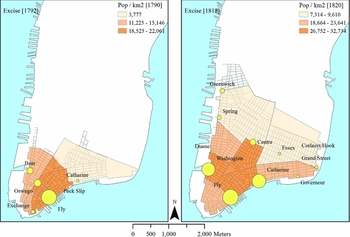
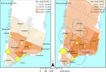
The analysis makes use of six maps.Footnote 22 First, it documents the spatial development of the public market system with snapshots from 1792, 1818, 1835 and 1855. Second, it maps the distributions of unlicensed vendors in 1841, and licensed meat shops in 1843–44, shortly before and after deregulation.Footnote 23 For each map, the size of the circles corresponds to the relative volume of trade of the individual public markets: for 1792 and 1818, the data come from excise taxes paid on the sales of butcher's meat,Footnote 24 while for the other years, from the amount of rents paid by the butchers and market fees collected from all other vendors.Footnote 25 Market maps are overlaid on population density maps at the ward level, the smallest spatial unit available from the censuses.Footnote 26
The maps of 1792 and 1818 (Figure 2) embrace the first period, when in quantitative terms, the Council made the necessary investments to enlarge the public market system at the rate of urbanization. It is possible, however, that under the pressure of urban growth, some areas became oversupplied, while others were left underserved by market facilities. Looking at the original infrastructure, the 1792 map depicts a dense walking city, where households relied on a provisioning system dominated by Fly Market, comprising about two-thirds of the food trade, complemented by smaller local markets, Oswego, Bear, Exchange, Catharine and Peck Slip, in order of size. As expected, marketplaces were located at about equal distance from their nearest neighbours, covering the entire city, all but one located near the waterfront. For a small and compact city, this centralized model was reasonable. Fly Market anchored the food trade at the most densely populated central districts, accessible by a 15-minute walk even from the remotest areas. Agglomeration at such a scale allowed customers to purchase all varieties of foodstuff at one location, and engage in comparison shopping for quality and price. For those who found the distance too taxing, neighbourhood markets offered more convenient access to provisions.
Public market system (1792, 1818)

By the early nineteenth century, the geography of the public market system needed readjustment. The 1818 map (Figure 2) captures the consolidation of a new spatial logic, characterized by a polycentric and two-tiered infrastructure. On the first point, public markets remained evenly spaced, each serving as independent retail centres for their areas, ensuring that all residents had access to a marketplace within a manageable 10-minute walk.Footnote 27 On the second point, data on the markets’ size and volume of trade reveal the gradual development of a two-tiered hierarchy, with densely populated central districts being supplied by the comparably large Fly, Washington and Catharine Markets, and newly urbanizing, more thinly populated areas up north relying on the smaller Duane, Spring, Greenwich, Centre, Essex, Grand Street and Governeur Markets. Differences in the scale of the individual markets mirrored the distribution of the population. In fact, a strong association existed between the hierarchy of the public markets and the population density of their catchment areas’ wards. Overall, in the first period, the public market system not only was expanded at a sufficient rate, but was also geographically well designed, reaching all residents and delivering food supplies to where there was demand, a considerable achievement of municipal governance.
Moving to the next period, when the market infrastructure was still expanding, yet investments fell behind urban growth, the 1835 map (Figure 3) reveals new fissures within the system's geography. Two patterns emerged. First, with overall trade rapidly increasing, Fulton and Washington Markets began to acquire wholesale functions, the former mainly in the fish trade and the latter in all types of food. Second, this still nascent differentiation was coupled with a less effective retail geography. Even as new public markets were built north, Jefferson and Tompkins specifically, while the infrastructure continued to be evenly spaced, covering most of the urbanized area, the population started to relocate in ways that the system failed to accommodate. Consequently, the previously strong association between the public markets’ capacity and volume of trade and their catchment areas’ population density weakened. The municipal system, while still binding, began to fall short of its mandate to provide access to food to all residents.
Public market system (1835, 1855)

The subsequent map from 1855 (Figure 3), a decade past deregulation, well illustrates the advancement of these trends.Footnote 28 By this time, the wholesale trade consolidated at Washington and Fulton Markets, but these were not optimal locations, for either site lacked railroad connection, and they were also increasingly far from the centre of population growth. More to the point, as the public market system stopped expanding, urbanizing areas north of Fourteenth Street were entirely left without municipal facilities. Further, the public markets’ capacity and volume of trade completely disassociated from local population densities. The most densely populated central-eastern wards were served by some of the smallest, most inadequate marketplaces. Overall, the municipal system's decline was a two-decade-long process, noticeable by the mid-1830s, but clearly evident only after liberalization. The main shortfalls were inadequate northward expansion and the gradual decoupling of retail capacity and residential density, in effect, supply and demand. This highlights two potential weaknesses of the municipal system. First, that the model's success depended largely on city officials, whose record turned from commitment to negligence. Second, that some inertia by definition characterized the municipal model, for earlier capital investments may have failed to anticipate future growth.
The potential benefit of an unregulated system was precisely its flexibility to co-ordinate between supply and demand almost immediately. In fact, residents typically expressed their concerns about the municipal model on spatial grounds, requesting the Council to build a new public market in their vicinity for they lacked easy access to any, or defending unlicensed vendors to be allowed to continue their sales temporally. Insofar as residents’ petitions served as the first step to identify the location of a new marketplace, this was part of the regular political process. Once petitioners faced increasing inertia by city officials, this created gaps in the geography of the public market system.
Clearly, by the mid-1830s there were ample spaces open for unlicensed retailers to occupy, and many who had failed to obtain a market stall took their chances. The 1841 map (Figure 4) provides a rare opportunity to look at the locational patterns of this informal economy. It documents approximate addresses for 59 cases of market law violations: vendors fined for selling fresh meat on the street or in their improvised shops. As expected, the spatial logic was one of dispersal, with retailers moving directly near to customers. At the same time, unlicensed vendors also worried about competition, and thus they often sought out spaces in between the catchment areas of established marketplaces. This was clearly the case in the western wards, between Centre, Clinton, Jefferson and Tompkins Markets, but less so in the eastern wards, where they penetrated the territories of Catharine, Centre, Essex and Union Markets.
Unlicensed (1841) and licensed meat vendors (1843–44)

Larger data from 1843–44, immediately after deregulation, listing the addresses of 273 meat shops, confirm the same retail geography (Figure 4). Three locational patterns stand out. First, as predicted, the unregulated model followed the logic of dispersal, with meat shops spreading evenly, carving out their own exclusive catchment areas of customers within a short one to two blocks radius. Second, shop butchers had strong incentives to circumvent competition from the public markets. Again, this was more evident for the four western marketplaces, whose areas remained relatively clear of newly licensed butcher shops, while in the eastern wards, meat shops often directly challenged public market vendors, a situation especially clear for Essex Market. The fact that the municipal system lacked substantial capacity in these densely settled neighbourhoods may explain the explosive growth of private sector retail. Third, the close similarity between the two maps of unlicensed and licensed vendors, just a few years apart, confirms the earlier point that deregulation was in practice the legalization of an already bourgeoning informal trade.
Overall, the spatial analysis completes the assessment of the provisioning system's long-term development. In the Early Republican period, the Council not only invested adequate resources into the public markets, but to the credit of the political process, the infrastructure also demonstrated considerable dynamism and flexibility. It was geographically well designed and kept up-to-date, reaching residents in all neighbourhoods even as New York experienced its onset of modern urbanization. Yet this consensus did not survive the antebellum era. The pressures of urban growth and shifting population densities, along with waning commitment from city officials, resulted in scanty investments and spatial discrepancies. Unlicensed vendors crowded into the economic and spatial niches that opened up. These fissures gradually widened, and the council eventually abandoned its traditional grip over the retail food markets. The private sector expansion that followed, in turn, profoundly altered the geography of provisioning. Whereas the municipal model agglomerated the sale of food supplies into a dozen or so tightly controlled public markets, the liberal regime that replaced it fragmented food retail into thousands of individual locations: market stalls, groceries, meat shops and street vendors. They dispersed across the city, and were left to their own devices, unregulated and unmonitored.
Conclusions
This article makes a contribution on two grounds. As a case-study, it presents a new interpretation of the geography of food provisioning in America's first metropolis during the city's take-off period of modern urbanization. Theoretically, it documents how distinct political economies produce different geographies of retail food distribution, and outlines the underlying spatial principles of the public market system.
As for the specific case, the analysis pays particular attention to institutional change and infrastructural growth in the context of urbanization, and outlines the chronology of food provisioning in New York City over the first half of the nineteenth century. First, between the 1790s and mid-1820s, robust population growth from 30,000 to over 150,000 was sustained by a steadily expanded and spatially well-designed market infrastructure. In this period, New York presents the best-documented case of how in an American city the municipal model served to ensure the public good of citizens’ access to food. The second period, lasting until the early 1840s, witnessed the gradual weakening of this institutional framework. As infrastructural development fell behind the needs of a city reaching 300,000, unlicensed vendors began to seize the opportunities left open by the public markets. Informal privatization anticipated and accelerated the transition to the third period of liberalized distribution, which characterized the provisioning system through the rest of the timeframe studied. Even as Gotham's population surpassed half a million by mid-century, the municipal government withdrew from its traditional responsibility to manage and oversee the institutions and daily practice of food retail. As urban provisioning gradually shifted to the private domain, its geography increasingly relocated from the marketplaces to the thousands of independent food purveyors whose businesses operated all across the city.Footnote 29
At the theoretical level, the article outlines how the distinct political economies of public market versus free market based provisioning produced different geographies of food retail. That an unregulated system facilitates the even dispersal of meat shops is little surprising. It is precisely what the central-place model predicts, and what scholars have found for food vendors in other places.Footnote 30 More uniquely, the New York case allows for observing the locational patterns of not only licensed but also unlicensed butchers. Additionally, it shows how for both groups dispersal was disrupted by the catchment areas of nearby public markets, creating zones of either mutually exclusive or overlapping coverage depending on the intensity of competition. Further, in comparison with the municipal system, the free market model's vitality to co-ordinate between supply and demand in a timely fashion is evident.
A second theoretical point concerns the public market system's geographic principles. Expanding on central-place theory, the study shows that to be effective the public market system has to negotiate the competing dynamics of dispersal and agglomeration. Despite their greater range, public markets need to be spaced evenly to ensure that all residents have access to at least one location within walking distance. At the same time, given their agglomeration economies, the size, capacity and volume of trade of the individual marketplaces have to match their catchment areas’ demands. The success of a retail market system therefore hinges on a polycentric and balanced geography, a point where early nineteenth-century New York and modern Barcelona reveal remarkable parallels.Footnote 31 Further, the two cases highlight how urban growth requires sustained commitment and administrative competence from the municipal body in charge to erect new facilities in urbanizing areas, and enlarge existing ones in increasingly densely settled older districts. One constraint is that due to the political mediation and capital investment involved the public market system has the potential for inertia, a problem that became evident in New York.
This last point compels a brief note about the benefits of the public market system. Here, the discussion can only allude to this issue, for it is not the subject of this article, and I explore this question elsewhere.Footnote 32 However, if free market co-ordination facilitates faster locational sorting, and brings food vendors closer to customers, without any political mediation, what is the rationale for a municipal provisioning system?
The answer lies with the logic of agglomeration. In effect, what New York City's public market system achieved by legislative means was to concentrate the sale of food supplies in and around a dozen neighbourhood retail centres. Even if marketplaces anticipated longer commutes from customers, comparable time savings were made by purchasing all provisions at one location. Importantly, public markets are external scale economies: they agglomerate dozens, even hundreds of independent vendors whose businesses complement and compete with each other. In this sense, the municipal model pushed food retailers to a higher centrality, whereby convenience goods could behave like comparison goods, enabling customers to comparison shop for price and quality, a far more difficult practice in a landscape of dispersed locations. Indeed, whether looking at formal market-houses in early nineteenth-century New York or modern Barcelona, or exploring the informal street markets of Victorian London, the neighbourhood context was vital for their thriving retail environments.Footnote 33
Shifting focus from individual and neighbourhood level benefits to the scale of the entire city, it was the subject of food quality where New York's public market system contributed to an even greater public good. Thanks to their privileged status and agglomeration economies, municipal markets functioned as the city's only institutions of quality control. In this regard, one may consider Gotham's municipal markets akin to the proverbial panopticon: market officials were assigned to monitor everyday retail practices and quality to enforce the market laws’ standards; vendors constantly kept an eye on each other to protect their businesses from unfair competition; and customers, on their part, compared the same provisions across different retailers. The three parties of the municipal model hence all kept their gaze on the daily transactions of food vendors and customers.
Importantly, the municipal model's benefits could only serve the public good insofar as all neighbourhoods were conveniently and sufficiently furnished with market facilities, that is, the principles of dispersal and agglomeration were consistently kept in balance with urban growth. As the analysis shows, this is where the system eventually fell short of its mandate, and not because it was inherently archaic or structurally flawed, but for the more mundane reason that city officials in New York no longer allocated adequate resources to guarantee its proper functioning. In fact, Barcelona's example demonstrates how a robust, spatially well-designed system could supply populations in the long term and over periods of rapid urbanization.Footnote 34 Even as New York City boasted a comparably sophisticated system nearly a century prior, changing municipal priorities gradually left the infrastructure in dire straits to address accelerating urbanization. On this point, the history of nineteenth-century New York's municipal market system recalls the fate of so many other public services, where insufficient social investments are mistakenly interpreted as evidence of the intrinsic failure of government provisions.