INTRODUCTION
Landscape is the result of many structural and dynamic processes, both natural and anthropogenic. The natural and socioeconomic components constitute a co-evolving system (Norgaard Reference Norgaard1984; Turner et al. Reference Turner, Lorenzoni, Beaumont, Bateman, Langford and McDonald1998), so that modifications in the structures and social processes normally affect the environment (Lorenzoni et al. Reference Lorenzoni, Jordan, Hulme, Turner and Riordan2000). Rapid changes in the cultural landscape are induced by human pressures affecting its ecological, rural and socioeconomic characteristics (Antrop Reference Antrop2005). These changes are partially due to the influence of globalization, which originated in technological and socioeconomic development (Turner et al. Reference Turner II, Gómez-Sal, Bernáldez and Di Castri1995; Tenhunen et al. Reference Tenhunen, Lenz and Hantschel2001). This is particularly important in Mediterranean landscapes, which are subject to intense substitution of uses and a high degree of external pressure, both in cultural landscapes managed for centuries (Bernáldez Reference Bernáldez, Pineda, Casado, De Miguel and Montalvo1991; Bunce et al. Reference Bunce, Pérez, Elbersen, Prados, Andersen, Bell and Smeets2001) and in relatively unexploited marginal areas.
The most common forms of pressure on the landscape derive from changes in the planning and management of agro-ecosystems. Rural abandonment and agricultural intensification are the result of a model of intensive agricultural development based on the use of modern techniques, aimed at high productivity and requiring high energy consumption (Benjaminsen Reference Benjaminsen2001). Such intensive agriculture replaces traditional activities associated with rural culture, which are on the verge of disappearing.
The European Union's model of intensive agricultural development applied in some regions of the Mediterranean with financial benefits may be environmentally unsustainable, owing to economic and socioeconomic restrictions on farmers maintaining subsistence economies (Lambin et al. Reference Lambin, Turner, Geist, Agbola, Angelsen, Bruce, Coomes, Dirzo, Fischer, Folke, George, Homewood, Imbernon, Leemans, Li, Moran, Mortimore, Ramakrishnan, Richards, Skånes, Steffen, Stone, Svedin, Veldkamp, Vogel and Xu2001). On the Iberian Peninsula, this development has led to a notable shift of rural populations to cities and widespread abandonment of the countryside. The associated socioeconomic changes are characterized by a decrease in the number of farmers working the land and the employment of many people in the secondary and tertiary sectors of the economy (Schmitz et al. Reference Schmitz, De Aranzabal, Aguilera, Rescia and Pineda2003). This rural abandonment has eliminated the traditional activities that maintained ancestral cultural landscapes (Baldock et al. Reference Baldock, Beaufoy, Bennett and Clark1993; Bischoff & Jongman Reference Bischoff and Jongman1993; Höchtl et al. Reference Höchtl, Lehringer and Konold2005) and can now be seen as a cultural loss. This has serious consequences for the ecological processes that agriculture had been maintaining, leading for instance to scrub encroachment and more fires. This, together with new processes related to agricultural intensification (such as irrigation, canals, water transfers, pollution, new infrastructures and urbanization), is associated with a complex set of environmentally unbalanced economies (Fernández-Alés et al. Reference Fernández-Alés, Martín, Ortega and Alés1992; Díaz Pineda Reference Díaz Pineda, Morey and Mayol2000).
There has been a parallel development of tourism throughout the world, with a steady increase in demand. At seaside resorts, tourist values are often related to characteristics such as temperature and the quality of the water (Uyarra et al. Reference Uyarra, Côté, Gill, Tinch, Viner and Watkinsosn2005). Traditional rural systems have environmental potential based mainly on the cultural landscape, for which there is a growing demand, and the quality of its varied products, which are becoming scarcer (De Miguel & Pineda Reference De Miguel, Pineda and Delgado2003; FIDA [Fundación para la Investigación y el Desarrollo Ambiental] 2004). Planners may evaluate the development of new territorial uses in relation to recreational and cultural tourism (German Federal Agency for Nature Conservation 1997; Fernández et al. Reference Fernández, Rescia, Aguilera, Castro, Schmitz, Pineda, Brebbia and Pascolo2000). Careful evaluation of the effects of tourism upon the territorial structure is an important planning objective, as some tourists are attracted by environments characterized by their fragility within their own socioenvironmental system. Environmental fragility related to tourism is the degree of sensitivity of landscape characteristics to environmental changes imposed by human stress (Petrosillo et al. Reference Petrosillo, Zurlini, Grato and Zaccarelli2006).
The interconnection between ecological processes, socioeconomic structure and cultural heritage (De Graaf et al. Reference De Graaf, Musters and ter Keurs1996; Musters et al. Reference Musters, de Graaf and Keurs1998) has also come to be conditioned by the new demands of tourism. The idea of ‘sustainable development’ has begun to dominate the debate on tourism (WWF [Worldwide Fund for Nature] 1995; Gössling Reference Gössling2000, Reference Gössling2002a; Tisdell Reference Tisdell2001).
Sensible environmental tourism could involve best use of the natural resources in a given area, and should include protected areas and natural and cultural spaces that are particularly ecologically sensitive. Sustainable tourism might ensure that some of the profits generated are invested in the management and protection of habitats and biological diversity. Consequently, the quality of life of the local population affected by territorial ecological processes could also be improved, leading to the revitalization of traditional local agricultural production (Klein et al. Reference Klein, Humphrey and Franklin1995; Goodwin Reference Goodwin1996; Hjalager Reference Hjalager1996; Gadd Reference Gadd2005). The arrival of tourism in areas considered interesting as a result of their landscape and culture provides potentially higher earnings for the local populations, for example through the provision of accommodation in country guest houses, restaurants, agricultural products, foodstuffs and handicrafts, gardening and educational farms. Increasing local employment helps establish close links between the recreational use of nature and conservation, and this can support the maintenance of traditional landscapes and their uses (King & Stewart Reference King and Stewart1996).
With regard to landscape valuation by visitors, the diversity of appreciation of an individual landscape can be so great that many researchers have failed to establish analytical criteria for determining the quality of this landscape, which would serve to provide a classification system for landscape qualities. Studies of landscape based on perception have established typologies using subjective appraisals of a quantitative or qualitative nature, which may rely on comparisons between visually appreciated pairs of scenes, like photographs or drawings (Ruiz & González-Bernáldez Reference Ruiz and González-Bernáldez1983; Bernáldez et al. Reference Bernáldez, Abelló and Gallardo1989; Múgica & De Lucio Reference Múgica and De Lucio1996; De Lucio et al. Reference De Lucio, Mohamadian, Ruiz, Benayas and Bernaldez1996). It is difficult to separate the idea of landscape from the predisposition of the observer to appraise it, either positively or negatively, using aesthetics-based criteria. Certain landscapes are more attractive than others, according to their rareness, the emotional atmosphere they transmit to different types of visitors and the feelings they provoke in the beholder. However, a description of landscape qualities can also be based upon analytical or synthetic parameters. Thus, in the valuation of a landscape, rational and emotional aspects coexist. Both of these ought to be taken into account in environmental planning and management of a landscape, particularly with regard to strategies for the development of tourism activities.
This paper characterizes rural cultural landscapes in Central Spain and the visitors to them and introduces a new methodological approach which enables both the objective environmental experts' assessment of different types of landscapes and the subjective appraisal of visitors to be compared. We consider characteristics of the landscape that have the potential to attract tourists, both natural and rural. We also analyse the tourists' perceptions of landscape typology, the associated potential spatial distribution and the similarity between the landscape characteristics and the visitor preferences. The cartographic representation of the analyses constitutes a novel tool for the management and planning of the tourism and recreational uses of a given region.
METHODS
Study area
We considered the province of Madrid (Central Spain), an area of c. 8000 km2. Just over one-third of the landscape, to the north and west, is comprised of mountainous siliceous terrain and foothills, the remainder being the sedimentary basin of the Tagus river, an agricultural landscape to the centre and east. From the north-west to the south-east, there is an environmental gradient ranging from 400 m above sea level in the valleys to altitudes of 2000 m on the mountain summits.
From early times, this territory has been used for different human activities, some of which are well integrated and dependent on the characteristics of the natural environment, such as traditional mixed rural systems based on agriculture, forestry and pastoralism. In our study area, the tourism value was determined by the landscape formed as a result of ancestral agricultural activities, and is therefore susceptible to current changes in land use. Although there have been major changes in the landscape over the last few decades because of the intense socioeconomic change, there are still regions of great natural, agricultural and aesthetic-cultural value, which offer possibilities for cultural tourism (Díaz Pineda Reference Díaz Pineda, Morey and Mayol2000; De Miguel & Pineda Reference De Miguel, Pineda and Delgado2003). The city of Madrid and the towns of the province were not considered in this study.
Tourism currently exerts great environmental pressure upon most of the natural spaces (Gómez Limón & De Lucio Reference Gómez Limón and De Lucio1994), as local development strategies have frequently resorted to tourism and housing development for holiday homes (De Miguel & Pineda Reference De Miguel, Pineda and Delgado2003).
Classification of the visitors
The theoretical demand for tourism was examined through questionnaires to visitors over a one-year period (from autumn to summer) during vacation periods (weekends, Christmas, Easter and summer). We selected the subjects randomly, either by means of ‘itinerant questioning’ (covering a route within the area selected) or ‘on standby’ (at a specific point on the way through). No more than two people within each group, randomly selected, were consulted, in order to avoid possible redundancies in their answers; it was unusual to come across solitary visitors. We selected areas considered to be of particular interest for tourism, such as recreation areas, camp sites, and the neighbourhood of Environmental Education Centres in the protected areas. Although we conducted the interviews along specific routes or at specific points, the questions did not refer to those places, but rather to landmarks and components of the whole province of Madrid, although the interviews were not done in the city and we interviewed people who spent their spare time enjoying the non-urban landscape.
The questionnaires were based on the visitors' expectations and experiences, and their sociological and cultural profile. Visitors were asked questions in four classes, namely their (1) sociological profile, (2) identification of landscape features, (3) characterization of landscape preferences and (4) intended activities (Appendix 1, see Supplementary material at URL http://www.ncl.ac.uk/icef/EC_Supplement.htm).
The questionnaire was first refined using a survey of 50 visitors (Hughey et al. Reference Hughey, Cullen, Kerr and Cook2004) before the principal campaign involving 1549 questionnaires. A matrix of qualitative data with 157 variables corresponding to the landscape preferences of the interviewees (question classes 2–4) was set up. Groupings of visitors were obtained by factorial analysis of correspondence and agglomerative classification of the 10 main factors extracted from the ordination analysis and we detected homogeneities in the data structure by Ward's (Reference Ward1963) method. The sociological variables (question class 1) constituted external descriptors (not included in the numerical analysis) of the visitors.
Landscape analysis
We based the landscape analysis on available cartographic data, such as altitude, slope, geomorphology, drainage network, plant formations and land uses (CAM [Comunidad Autónoma de Madrid] 1995, 1998, 1999). We superimposed a 1 × 1 km grid over the vectorial map resulting from the intersection of the theme maps and calculated the cover percentage of the different classes of variables considered for each cell (Eastman Reference Eastman1997; ESRI [Environmental Systems Research Institute] 2002). The final result was a matrix of 7836 observations representing regular positions of the space described by 147 variables relating to natural characteristics and the natural uses of the area (Fernández et al. Reference Fernández, Rescia, Aguilera, Castro, Schmitz, Pineda, Brebbia and Pascolo2000). We used principal component analysis (PCA) to analyse the matrix data and obtained an agglomerative hierarchical classification analysis of the 10 main axes. We calculated the distances between objects using the Euclidean distance coefficient. The clustering algorithm was K-means (Legendre & Legendre Reference Legendre and Legendre1986; Jongman et al. Reference Jongman, Ter Braak and van Tongeren1995; Ludwig & Reynolds Reference Ludwig and Reynolds1988). The geo-referenced expression of these analyses allowed for the design of hierarchical cartography (landscape type map) that responded to a multivariate description of the area (De Pablo et al. Reference De Pablo, Gómez-Sal and Pineda1987).
Valuation and perception of the territory with regard to tourism
The questionnaires enabled us to evaluate and quantify appreciation of different characteristics of the landscape by the type of visitors. Some of these characteristics could be referenced geographically, and the area could then be expressed according to these characteristics. The perceived ecological components of the landscape contribute to the perception of its typology and environmental state and influence the preferences and appraisal of the observers (Van der Zee Reference Van Der Zee1990; Nassauer Reference Nassauer1995; Naveh Reference Naveh1995). The spatial analysis of the interaction between both quantifications allowed us to identify the degree to which the zones of the area match the preferences of the tourists. Based on the questions asked in the survey, we selected 32 landscape variables (Appendix 1, see Supplementary material at URL http://www.ncl.ac.uk/icef/EC_Supplement.htm).
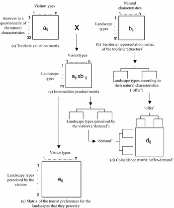
The procedure was based on two sets of data (Fig. 1), namely (1) a valuation matrix of the natural landscape characteristics (Fig. 1a), its elements (aij) quantifying the answers by the types of tourists identified by the questions asked about the 32 spatial variables, and (2) a matrix of landscape representation of the factors attracting tourism (Fig. 1b), its elements (bij) quantifying the presence of the 32 territorial characteristics in the eight types of landscapes previously obtained. By a classification analysis of the matrix (Fig. 1b) we established the landscape groups characteristic of the area, considering the natural variables selected. The landscape types thus obtained represented the potential tourism ‘offer’ of the landscape.
Methodological development based on a multiplication of matrices [a] × [b]. The resulting product matrix, [c], quantifies the demand by the tourists for the territorial variables. A classification analysis of the matrices, [b] and [c], quantifies the offer and demand respectively. The correspondence of the groups of landscapes that represent the territorial offer and the demand by the visitors, [d], was calculated with the use of a matrix of coincidences. [e] is the matrix of preferences of the tourists for the landscapes they perceive.

Likewise, in order to ascertain visitors' perceptions of the landscape, we calculated a matrix product, the elements of which (aij × bij) quantified the tourist demand for the spatial variables (Fig. 1c). A classification analysis of this intermediate product matrix indicated the landscape types perceived by the visitors to the area or their ‘demand’.
Space-preferences coincidence analysis
In order to establish the concordance between the characteristics of the area and how the different types of visitors perceived them, we made a comparison of the clusters obtained from the matrices for groups of landscapes according to their natural and rural characteristics (Fig. 1b; ‘offer’) and groups of landscapes perceived by the tourists (Fig. 1c; ‘demand’). The correspondence between them was obtained by using a table of contingencies of the respective groups (Fig. 1d). The similitude (dij) between the groups of classifications was calculated as the quotient between the number of common observations in the groups of one or another classification and the total number of different observations in each group.
Analysis of satisfaction of the demand
The results of the analysis of the visitors' perceptions and demands (Fig. 1c) were used to construct a new matrix of tourist preferences for the landscapes perceived (Fig. 1e). Elements eij represented the mean values of the discriminant variables in the types of landscape appreciated by visitors. The values of the matrix vectors quantifying the tourists' preferences for the landscape types were standardized and divided into three categories (high, medium and low) using the natural break method.
Analysis of visitor spatial niche
Applying to this matrix of preferences (Fig. 1e) the parameters of niche width and overlap derived from the theorem of total entropy (Pineda et al. Reference Pineda, Nicolas, Ruiz, Peco and Bernáldez1981; Castro et al. Reference Castro, Carrique, Rescia, Aguilera, Schmitz and Pineda2000), enabled us to establish the distribution characteristics of the visitors throughout the area. Thus it was possible to establish the degree of coincidence in the occupation of the landscapes by the different visitors, along with the uniformity or heterogeneity of this occupation (Appendix 2, see Supplementary material at URL http://www.ncl.ac.uk/icef/EC_Supplement.htm).
The mean niche width and the spatial niche width A of the set of visitors considered were calculated through the expression:

H(L/V) being the entropy of the landscape L conditioned by the visitors V. This is a measure of the uncertainty of finding a given visitor, considering their preferences, in a determined landscape. N is the total number of landscape types considered. A varies from 0 (heterogeneous occupation of landscapes by different visitors) to 1 (uniform occupation of landscapes by visitors; Appendix 2, see Supplementary material at URL http://www.ncl.ac.uk/icef/EC_Supplement.htm).
The mean niche overlap and the spatial niche overlap S of the set of visitors was measured by:

This measures the uncertainty that a given landscape may be occupied by a particular type of visitor. T is the number of types of visitors considered. S varies from 0 (no coincidence in the occupation of the landscapes by the different visitors) to 1 (total coincidence in this occupation; Appendix 2, see Supplementary material at URL http://www.ncl.ac.uk/icef/EC_Supplement.htm).
RESULTS
Visitor type
The analyses of the matrix of tourists' questionnaire responses enabled us to detect the types of visitors and the territorial variables characterizing them. Variables occurring frequently in the tourists' preferences and representing over 65% of the total sample were descriptors of mountain areas and presence of water in the landscape (rivers and water surfaces). The most valued activities were those related to nature, contemplation of the landscape and bird-watching. The main reason for visiting natural spaces was related to leisure time and vacations. Most of the visitors came from the province of Madrid (96%), with few from the rest of Spain (3%) or abroad (1%).
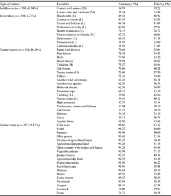
Using the variables with the greatest discriminant value, we described four types of visitors with different attitudes to and perceptions of the territory (Table 1). ‘Indifferents’ (46% of the total) simply enjoyed spending their free time in the open air, showing no preference for any particular type of landscape or activity related to the natural or rural environment. ‘Generalists’ (7%) characterized by low-level appreciation of the variables representing the natural and cultural offer of the territory, were visiting mainly for leisure and, to a lesser degree, their families or jobs; they valued the proximity of nature to their place of residence. ‘Nature/sports’ visitors (28%) and ‘nature/rural’ visitors (19%) both showed great interest in and knowledge of nature and the rural environment, nature/sports visitors showing a preference for sports and cultural landscapes, while nature/rural visitors' interests were particularly in agriculture and livestock farming.
Discriminant variables for the types of visitors in the study area. The selection criteria are based on constancy values (presence of each variable in each group) and fidelity values (the capacity of each variable to predict a group). H = high, M = medium and L = low valuation for each question.

Natural and rural offer of the landscape for tourism
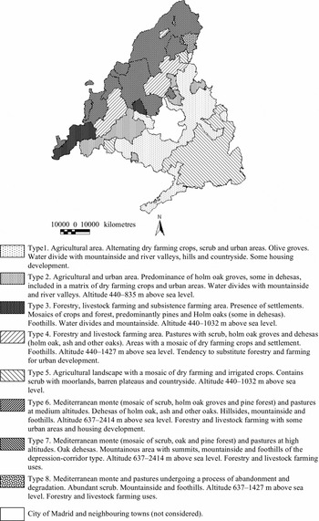
The successive ordination and hierarchical classification analyses enabled us to detect discontinuities between sets of observations, and facilitated the division of the territory into eight landscape types (level of similarity between groups = 0.521; Fig. 2).
Landscape type characterization. Ecological sectoring of Madrid area based on an ordination and classification analysis of a data matrix of altitude, slope, geomorphology, drainage network, plant formations and land uses (percentage of cover in 1 km2 cells of a grid covering the whole territory).

In this numerical description of the landscape, some of the discriminant variables of the different landscape sectors were readily perceived and identified within the landscape (these express the ‘phenosystem’ or appearance of the landscape), whereas, in general terms, it is more difficult to identify others (which belong to the ‘cryptosystem’ or the ecosystem hidden from the senses; Bernáldez Reference Bernáldez1981). For example, it is relatively easy to identify vegetation and agricultural uses, but not to establish the mean temperature of the coldest month, or evapotranspiration.
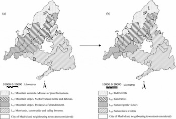
Although the two types of variables used in the analyses were indicators of the complex mesh of ecological relationships underlying the different landscape units, we considered as ‘tourist attractors’ those characteristics that could easily and quickly be perceived by the occasional visitor. Thus, the classification analysis of the territorial representation matrix (Fig. 1b) showed for the 32 natural variables selected that the area was divided into four landscape groups (Lt1–Lt4) that represented the types of potential tourist attractions in the area (Fig. 3a).
Map showing the territorial offer and demand by tourists. (a) Classification of the landscape based on the natural characteristics that can be easily and quickly perceived by visitors. (b) Landscape types perceived by visitors. Consult text for a detailed definition of landscape units.

Lt1 consisted of formations of broadleaf species and complex mosaics of scrub, holm oak groves, and oak and pine forests, with pastures on mountain tops and slopes. This landscape is used for forestry and livestock farming, and can be used for activities related to mountain walking, hunting and fishing. Lt2 consisted of pastures with scrub and holm oak groves, and oak and ash, and areas with mosaics of dry farming crops on mountain slopes and water divides of river valleys. This landscape is used for forestry, livestock farming and marginal agriculture, and there are some urban areas and a tendency towards substitution of uses by urban development. The main potential recreational activities are hunting and watching fauna. Lt3 consisted of Mediterranean monte (woodland areas with large accumulation of biomass and low productivity) and pastures undergoing a process of abandonment and degradation, with an abundance of scrub, on mountain slopes. The main recreational possibilities are hunting, watching land vertebrates (particularly birds), hiking, cycling and nature routes, fishing and water sports. Lt4 consisted of agricultural landscape with dry farming and irrigated crops, containing some scrub and settlements, on hillsides, in countryside and in river valleys. The recreation potential is related to hunting, observing aquatic vegetation and fauna, hiking, cycling and following other types of nature routes.
Visitors' perceptions of the area and landscape preferences
The classification analysis of the intermediate product matrix (Fig. 1c), eight ecological sectors × four types of tourists, indicates that the visitors only perceived four types of landscape (Lp1–Lp4; Fig. 3b). Lp1 was related to broadleaved deciduous forests, pine forest, scrub and high altitude pastures of mountain tops and slopes. The areas and geographic location of these coincides exactly with Lt1. Lp2 was related to Mediterranean monte, pastures with trees (dehesas) and scrub encroachment (matorralización) on mountain slopes. Lp3 was related to water divides and mountainsides in river valleys, containing mosaics of crops, pine forest, holm oak groves and dehesas, with some urban areas. Lp4 consisted of mosaics of crops and some settlements in moorlands, countryside and valley bottoms. The territorial limits of this landscape unit overlapped with Lt4.
Spatial concordance between ‘territorial offer’ and ‘demand for tourism’
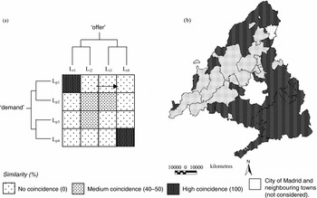
There was complete coincidence between the two forms of description of the territory in the case of mountainous areas and predominantly agricultural landscapes (Lt1–Lp1 and Lt4–Lp4, respectively), whereas there was medium or no coincidence in the sectors representing formations of Mediterranean monte, with greater or lesser degrees of abandonment of traditional uses (Fig. 4).
(a) Matrix image and (b) cartographic representation of the comparison of landscape types obtained in the analysis of the territorial offer and the visitors' preferences. The coincidence of the two forms of description of the territory is maximum (similarity 100%) between Lt1 and Lp1 (mountain landscapes) and Lt4 and Lp4 (agricultural landscapes). See text for a detailed explanation of landscape units.

‘Satisfaction’ of the demand
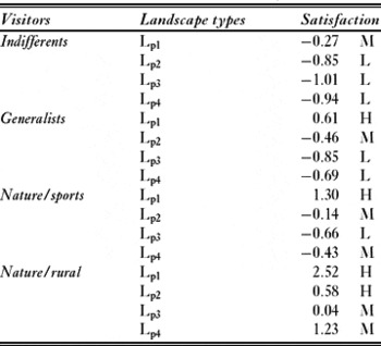
We obtained values of relative ‘satisfaction’ for the four types of visitors in the study area (Table 2). The three categories (high, medium and low) of the matrix vectors used to value visitor preferences for different landscape types (Fig. 1e), aids interpretation of the visitor landscape preferences, and can be used to construct maps expressing relative satisfaction (Appendix 3, see Supplementary material at URL http://www.ncl.ac.uk/icef/EC_Supplement.htm). Medium and low values predominated with indifferent and generalist visitors, while nature/rural visitors were characterized by high levels of satisfaction. All visitors showed a preference for high-mountain landscapes.
Relative satisfaction attained by the visitors in the landscapes they perceived (Lpn). We classified the values of the matrix of the tourist preferences and divided them into three categories using the natural break method: L = low, M = medium and H = high satisfaction level (L = −1.01 to −0.66; M = −0.65 to 0.04; H = 0.05 to 2.52).

‘Outdoor recreational niche’ of the visitors
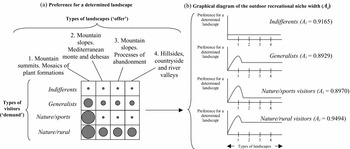
The mean niche width and mean niche overlap calculated using the visitor preferences matrix indicate a high degree of homogeneity in the occupation of the area by different groups of visitors. There was no significant spatial segregation in their distribution. All groups showed large values for the spatial niche width, especially the nature/rural visitors (Table 3); this can be interpreted as the visitors' ‘outdoor recreation niche’, and indicates that, regardless of the degree of visitor satisfaction in the different landscapes, their potential spatial distribution would be extensive.
Spatial distribution of the visitors according to their preferences. Calculation of the parameters niche width and overlap in the matrix of the visitor preferences. Both parameters are measured in bits. Entropy H(L/V) of the landscape (L) conditioned to the visitors (V) = 1.844 and entropy H(V/L) of the visitors (V) conditioned to the landscape (L) = 1.803, mean niche width A of the visitors = 0.922 and mean niche overlap S of the territory = 0.902.

There was also a high outdoor recreation niche overlap in the area's sectors, especially in the more mountainous landscapes with steep slopes containing Mediterranean monte in varying degrees of conservation (Table 3; Appendix 4, see Supplementary material at URL http://www.ncl.ac.uk/icef/EC_Supplement.htm).
DISCUSSION
Territorial offer and demand for tourism
We characterized the area according to its potential attractiveness to tourists and classified visitor type. We established eight landscape types based upon local natural and cultural characteristics and the way these are perceived by visitors. We subsequently established relationships between tourist preferences and the spatial distribution of the features of the landscape.
Visitor behaviour was based upon general tourism stereotypes, with both generalist and specialist tourists (Gulinck et al. Reference Gulinck, Vyverman, Van Bouchout and Gobin2001; Aguilera et al. Reference Aguilera, Schmitz, De Aranzabal, Pineda, Brebbia and Pineda2004; Schmitz et al. Reference Schmitz, Fernández-Sañudo, De Aranzabal, Pineda, Brebbia and Pineda2004), however they all emphasized the importance of nature as an element of reference. There were different types of visitors with greater or lesser degrees of specialization. Among the most specialized were visitors attracted by the natural and rural environment, interested in nature, the traditional cultural landscape and sports-orientated pursuits.
This method for establishing visitor valuation of the landscape using its ‘readable’ elements (the different units making up the landscape considered in the survey) enabled us to quantify preferences for specific elements of the area. Other procedures used for interpreting tourist preferences deal with landscape in a global manner, namely methods based upon photography or analysis of the composition of the scene (De Lucio et al. Reference De Lucio, Mohamadian, Ruiz, Benayas and Bernaldez1996; Múgica & De Lucio Reference Múgica and De Lucio1996; Arriaza et al. Reference Arriaza, Cañas-Ortega, Cañas-Madueño and Ruiz-Aviles2004). Assessing the desires, preferences and attitudes of the visitors in relation to the characteristics of the territory using multivariate analyses enabled us to consider all aspects defining visitor type and identify those most relevant, unlike studies that make use of monovariant analytical methods (Moran Reference Moran1994; Shin et al. Reference Shin, Jaakson and Kim2001; Soto et al. Reference Soto, Munthali and Breen2001; Hearne & Salinas Reference Hearne and Salinas2002; Roovers et al. Reference Roovers, Hermy and Gulinck2002; Winter & Lockwood Reference Winter and Lockwood2005).
Knowledge of visitor characteristics is fundamental to sustainable tourism. The varied types of people visiting the area and their differing attitudes and needs in relation to the landscape involve a differential approach in the management of the area for tourism. We should therefore always consider, as a basic conceptual framework, the characteristics of the natural environment in which the recreational use occurs. Planning new strategies for landscape uses, managing visits, controlling inland tourism trends and predicting recreational demand necessitates appropriate information on types of tourists and preferences.
We need to establish the type of visitors for a given area, not only according to aspects of their sociological profile, the frequency of their visits, their activities or the quality of the infrastructures they require (such as accommodation, access to the area in question and restaurants; Obua & Harding Reference Obua and Harding1996; Hearne & Salinas Reference Hearne and Salinas2002; Priskin Reference Priskin2003), but also in relation to the appreciation by the tourist of the landscape. This aspect constitutes one of the main reasons for a tourist to select a particular holiday destination.
Landscape maps describe the environmental characteristics that the area can offer in terms of leisure activities and recreation. The options, represented by the landscape, can be valued in terms of satisfaction of visitor demand, environmental impact of the foreseeable activities of these visitors (Schmitz et al. Reference Schmitz, Pineda, Castro, De Aranzabal and Aguilera2005) and tourism potential. These maps facilitate study of the relationships between characteristics of the landscape and demand for tourism recreation (De Aranzabal et al. Reference De Aranzabal, Schmitz and Pineda2003).
Landscape type and tourist perceptions
There are discrepancies between the visitors' perceptions of the area and the landscape type obtained through the ecological criteria used. This shows the importance of considering different criteria in assessing and sectoring the landscape for natural area management. We recommend that the principal national and international organizations and the private sector support research and development into the connections between tourism, conservation and socioeconomic development, as well as the socioecological fragility linked to visitor experiences, behaviour and impacts (Nassauer Reference Nassauer1992; Goodwin & Swingland Reference Goodwin and Swingland1996; Farrel & Marion Reference Farrell and Marion2001; WPC Reference Jones2005; Lacitignola et al. Reference Lacitignola, Petrosillo, Cataldi and Zurlini2007; Petrosillo et al. Reference Petrosillo, Zurlini, Corlianó, Zaccarelli and Dadamo2007). The potential development of natural and cultural tourism hinges upon managing the close relationship between tourism and landscape.
Spatial analysis of coincidences indicates a high correspondence between the natural and cultural potential of the landscape and visitor demand in the most mountainous landscapes and in those dedicated to agriculture; a matrix of interaction between offer and demand with maximum values of fit between both of them indicates total coincidence of the two interpretations of the territory (Montalvo et al. Reference Montalvo, Casado, Levassor and Pineda1991; Castro et al. Reference Castro, Carrique, Rescia, Aguilera, Schmitz and Pineda2000). The area would be made up of as many types of spatial units as there were types of visitors, whose preferences would be directed to a specific sector of the territory having the optimum composition of landscape variables preferred by a given tourist type. A high level of correspondence indicates that the territory comfortably accommodates the tourism demand it is subjected to and its spatial variation can be described by considering both the natural characteristics and the preferences of the visitors; one landscape-type map may be interpreted in two alternative ways.
Satisfying the demands of different visitor types reflects canonical (ideal) landscapes that adjust in varying degrees to reality according to the sectors of the area. Although the characteristics of the region provide variation in the degree of satisfaction which tallies with the increase in the level of specialization and knowledge of nature of the visitors, a clear preference was shown for the most mountainous landscapes.
Mountain landscapes have higher overlap values for the outdoor recreation niche of the visitors. By examining niche width and overlap, we observed extensive occupation of the territory by the different types of visitors, whose potential spatial distribution encompassed all the landscape types in different proportions (Fig. 5).
Diagram of the results of the outdoor recreational niche width of the visitors, Ai. (a) Representation in the form of a matrix of the degree of preference of each type of visitor for each type of landscape detected (indicated by the diameter of the circles; see Appendix 2, see supplementary material at URL http://www.ncl.ac.uk/icef/EC_Supplement.htm). (b) A graphic explanation of the niche width, Ai (values vary from 0 to 1; see Table 3): in ordinates the degree of visitor preferences for landscape types (see text); in abscissae, the four types of landscapes arranged from left to right.

CONCLUSIONS AND IMPLICATIONS FOR MANAGEMENT
Tourism has both physical (environmental) and psychological (related to perception and valuation) consequences (Gössling Reference Gössling2002b; Palang et al. Reference Palang, Helmfrid, Antrop and Alumäe2005), and these can alter what constitutes the tourist attraction. This shows the importance of aesthetic conservation, and ecological and social functions (Council of Europe 2000). The visitors' valuation of the different types of landscapes should therefore be taken into consideration when developing recreational activities associated with tourism. The qualities present can be described through analytical and synthetic parameters (Atauri et al. Reference Atauri, De Lucio and Gómez Sal2001; De Aranzabal et al. Reference De Aranzabal, Schmitz and Pineda2003; Schmitz et al. Reference Schmitz, Fernández-Sañudo, De Aranzabal, Pineda, Brebbia and Pineda2004). We need to know what this category of tourism demands (what type of landscape) and what type of tourist demands it.
Diverse institutional forums, such as United Nations of Environment Programme, World Tourism Organization (World Ecotourism Summit 2002), World Parks Congress (WPC Reference Jones2005), and the European Commission (2003), have set different international principles, directives, recommendations and codes of ethics on the development of sustainable tourism. However, there is little empirical evidence of the effects of tourism upon the landscape.
The method we developed enabled us to combine different assessments of the same area: the appraisal of the landscape units conducted by environmental experts and the appraisal of the landscape by the visitors. We constructed maps indicating the distribution of visitor preferences and possible visitation areas selected by different types of visitors, the degree of satisfaction with their current and potential preferences, the degree of correspondence or adjustment between the set of demands and the potential capacity of the territory to satisfy these. Indeed, we observed that visitors to the study area did not perceive or prefer the same landscape as that based upon ecological criteria, and this should be taken into account in the future management of the territory.
This methodological approach could contribute to establishing specific policies or strategies for the development of tourism based on the management of the area and landscape. This provides a useful reference for the design of rational tourism planning.