INTRODUCTION
There is increasing evidence that many fisheries are exploiting more and more deeper waters (Morato et al., Reference Morato, Watson, Pitcher and Pauly2006), resulting in a reduced abundance, biomass and size-structure (Pauly et al., Reference Pauly, Christensen, Dalsgaard, Froese and Torres1998; Sadovy, Reference Sadovy2001) of many deep-sea fish that cannot sustain high levels of exploitation, due to their characteristic slow growth, high longevity and low reproductive output (Clark, Reference Clark2001).
The Mediterranean deep-water crustacean trawl fishery (CTF) is the main form of deep-water fishery (reaching depths of ~850 m) in the central–eastern Mediterranean; this fishery targets deep-water shrimps, although several fish species are caught regularly as by-catch, including silver roughy Hoplostethus mediterraneus (Cuvier, 1829; Pisces: Trachichthyidae), which is almost always discarded. This species is the main trachichthyid caught in the Mediterranean basin, with only sporadic records of its exotic relative Gephyroberyx darwini (Johnson, 1866), which was first recorded in Algerian waters (Dieuzeide, Reference Dieuzeide1963).
Hoplostethus mediterraneus is a benthopelagic fish occurring on the middle slope in the eastern Mediterranean (Labropoulou & Papaconstantinou, Reference Labropoulou and Papaconstantinou2000), the south-western Mediterranean (Moranta et al., Reference Moranta, Stefanescu, Massutì, Morales-Nin and Lloris1998) and the north-eastern Atlantic (Gordon & Duncan, Reference Gordon and Duncan1987). Given its limited economic value, it has been subject to limited biological investigation. Available information concerns its horizontal distribution (Maurin, Reference Maurin1962, Reference Maurin1970), length- and depth–size distribution (Gordon & Duncan, Reference Gordon and Duncan1987; Mytilineou et al., Reference Mytilineou, Maiorano, Kavadas, D'Onghia, Kapiris and Capezzuto2001; Pais, Reference Pais2001), feeding behaviour (Kerstan, Reference Kerstan1989; Pais, Reference Pais2002; Madurell & Cartes, Reference Madurell and Cartes2005), reproductive cycle (Cau & Deiana, Reference Cau and Deiana1982; D'Onghia et al., Reference D'Onghia, Tursi, Marano and Basanisi1998) and age, growth and mortality (Kotlyar, Reference Kotlyar and Shirshon1980; D'Onghia et al., Reference D'Onghia, Tursi, Marano and Basanisi1998; Vitale et al., Reference Vitale, Cannizzaro, Bono, Beltrano, Ingrassia and Milazzo2004). The species shows heterogeneity in biological features at the population level.
Available abundance data for the species are characterized by a high variability. Many parts of the Mediterranean may not be optimal environments for H. Mediterraneus (Maurin, Reference Maurin1970). Furthermore, most Mediterranean bottom trawls operate in close contact with the sea bed (~1 m of vertical mouth opening), and such gears are not highly selective for silver roughy. Both commercial and experimental data highlight a wide variability in abundance indices, which range from usually a few g/h (Ligurian Sea; Di Natale et al., Reference Di Natale1995) up to quite large captures (over 40 kg/h in Greek waters; Madurell et al., Reference Madurell, Cartes and Labropoulou2004). Similar results were obtained from the biomass indices collected during the MEDiterranean International Trawl Survey, (MEDITS) programme (Bertrand et al., Reference Bertrand, Gil de Sola, Papaconstantinou, Relini and Souplet2002) from 1994 to 2010 in the General Fisheries Commission for the Mediterranean Geographical Sub Areas (GSAs) located in the central–eastern Mediterranean.
Hoplostethus mediterraneus tends to show a heterogeneous diffusion pattern, not only horizontally (even in close and very similar habitats; Maurin Reference Maurin1962), but also vertically (with larger fish occurring in deeper waters; D'Onghia et al., Reference D'Onghia, Tursi, Marano and Basanisi1998), presenting a dome-shaped distribution with preference between 500 m and 800 m depth (Cau & Deiana, Reference Cau and Deiana1982; Gordon & Duncan, Reference Gordon and Duncan1987; Morales-Nin et al., Reference Morales-Nin, Maynou, Sardà, Cartes, Moranta, Massutì, Company, Rotllant, Bozzano and Stefanescu2003; Follesa et al., Reference Follesa, Porcu, Cabiddu, Mulas, Deiana and Cau2011).
Difficulties also exist with regard to the demographic parameters. Both length- and age-based methods are difficult to apply and properly interpret for the potential influence of density-dependent mechanisms that lead towards population stability (D'Onghia et al., Reference D'Onghia, Tursi, Marano and Basanisi1998). In spite of the almost discrete recruitment (D'Onghia et al., Reference D'Onghia, Tursi, Marano and Basanisi1998), length–frequency distributions (LFDs) can show a variable shape, from skewed to the left (i.e. with a prevalence of juveniles; Pais, Reference Pais2001) to unimodal and centred (i.e. with poorly represented tails; Mytilineou et al., Reference Mytilineou, Maiorano, Kavadas, D'Onghia, Kapiris and Capezzuto2001). Whichever the shape detected, there is evidence that the parental (i.e. the mature component) size-classes are composed of different overlapping and slower growing age-classes (D'Onghia et al., Reference D'Onghia, Tursi, Marano and Basanisi1998); that is, the LFD is affected by piling-up phenomenona (Pauly, Reference Pauly1984).
Hoplostethus mediterraneus otoliths are thick and difficult to interpret, even after sectioning (D'Onghia et al., Reference D'Onghia, Matarrese, Tursi, Sion and Panza1995, Reference D'Onghia, Tursi, Marano and Basanisi1998; Vitale et al., Reference Vitale, Cannizzaro, Bono, Beltrano, Ingrassia and Milazzo2004), given the presence of multiple close checks of which some likely reflect ontological events, such as benthic and maturing checks (see Francis & Horn, Reference Francis and Horn1997). Consequently, uncertainty affects the estimated von Bertalanffy growth parameters K = 0.127 y−1 (confidence limit: 0.104–0.149), as well as the asymptotic (total) length L ∞ = 28.71 cm (confidence limit: 26.73–30.69) (D'Onghia et al., Reference D'Onghia, Tursi, Marano and Basanisi1998). The maximum age in samples (11 yr; D'Onghia et al., Reference D'Onghia, Tursi, Marano and Basanisi1998) likely reflects problems in ageing or maybe fishing-induced effects, since the life span should be ~25 yr (D'Onghia et al., Reference D'Onghia, Tursi, Marano and Basanisi1998).
No information is available concerning the stock identity of H. mediterraneus in the Mediterranean, but its life history traits (slow growth, high longevity, low natural mortality and the production of large, superficially buoyant eggs, i.e. more K oriented strategies), along with the almost steady deep-water habitats of the Mediterranean (Cartes et al., Reference Cartes, Maynou, Sardà, Company, Lloris and Tudela2004), may suggest a genetic homogeneity among the various populations (Maggio et al., Reference Maggio, Lo Brutto, Cannas, Deiana and Arculeo2009). Such conjecture is also supported by the connectivity role of the overall hydrodynamic circulation of the Mediterranean Sea, characterized by a superficial flow (Modified Atlantic Water (MAW)), from the western to the eastern side and a counter-flow (Levantine Intermediate Water (LIW)) of more saline, deeper water from the eastern to the western basin (Millot et al., Reference Millot, Candela, Fuda and Tber2006). In contrast, the typical poor swimming ability (Pakhorukov, Reference Pakhorukov2008) and patchy occurrence (i.e. likely also reflecting a low catchability sensu Alverson, Reference Alverson1971) of H. mediterraneus, along with the high heterogeneous fishing effort applied to deep-water crustacean fisheries, might determine population differentiation at a local scale. Hence, different unit stocks sensu Gulland (Reference Gulland1969, Reference Gulland1983) may be expected, since the low intermixing rates among contiguous stocks may be obscured by differences in fishing effort (Gulland, Reference Gulland1969; Ricker, Reference Ricker1975).
The present investigation provides a comparison of data on H. mediterraneus collected in fishing grounds subject to different histories and levels of exploitation, with the aim of investigating how local stocks respond to different fishing patterns, and to what extent measure bottom trawling may represent a threat to this long-living species.
MATERIALS AND METHODS
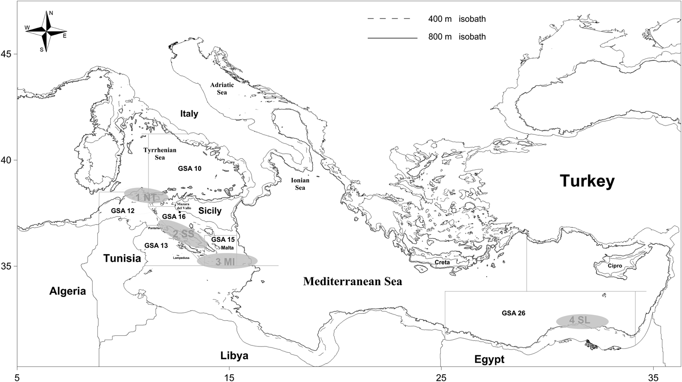
A voluntary, 12-month self-sampling programme (Vølstad et al., Reference Vølstad, Korsbrekke, Nedreaas, Nilsen, Nilsson, Pennington, Subbey and Wienerroither2011) was implemented in 2004 to collect H. mediterraneus specimens from four commercial trawlers. Direct sampling by scientists was not cost-effective during commercial fishing operations, given the long voyages (up to 4 weeks) that characterize the offshore crustacean trawl fishery. These trawlers operated in the upper slope (500–850 m) of four deep-water shrimp fishing grounds (FGs) in the central–eastern Mediterranean Sea (Figure 1). In agreement with the captain, a member of each crew was carefully instructed in the Institute for Marine and Coastal Environment–National Research Council (IAMC-CNR), in order to standardize data collection among each sampling vessel. In particular, each trained fishermen extracted monthly and randomly samples of at least 100 specimens from the gross catches. During the investigation, a fishery biologist visited the crew to assess and ensure the quality of the self-reported data. At the end of the field sampling, a total of 4962 H. mediterraneus were recovered.
The harbour of Mazara del Vallo and the four fishing grounds (Northern Tunisia, 1NT; South of Sicily, 2SS; Malta Island, 3MI; South Levant, 4SL) where commercial bottom trawlers collected samples of the silver roughy (Hoplostethus mediterraneus) in 2004. Present General Fisheries Commission for the Mediterranean delimitation (Geographical Sub-Area - GSA 10, 12, 13, 15, 16, 26) is superimposed.

The four trawlers, belonging to the fleet of Mazara del Vallo (south-eastern Sicily), had gross tonnage ranging from 188 tsl to 191 tsl; all vessels used the same typical ‘mazarese trawl net for deep shrimps’ with the following main characteristics: headline, 74 m; groundline, 76 m; cod-end mesh size, 40 mm; length from the headline to the cod-end end, 35 m; and wings, 30 m.
The four FGs exploited by trawlers from Mazara del Vallo only are: Northern Tunisia (1NT), characterized by a high level of exploitation since the 1970s; South Sicily (2SS), highly exploited since the 1980s; Malta Islands (3MI), with a minor level of exploitation due to the high occurrence of fish aggregation device moorings (mazzare); and South Levant (4SL), which represents a virgin bottom for CTF, because the fishery only started in 2004 (Garofalo et al., Reference Garofalo, Giusto, Cusumano, Ingrande, Sinacori, Gristina and Fiorentino2007).
To reconstruct the different histories and levels of exploitation in each investigated FG, the following steps were performed: (1) estimation of the evolution of the offshore fishing capacity using historical references of the 1960s (Istituto Nazionale di Statistica, 1977; Centro Internazionale di Studi Giuridici, 1988) together with the data from the Mazara vessels registry and the European Union fleet structure (EU fishing fleet register, 2013) by decades from 1970 to 2010; and (2) assessment of the spatial-time distribution of the trawlers in each FG, through semi-structured interviews with the last 10 captains of the 1960s and 1970s (between 70 and 83 years old) as well as with 20 ‘younger’ captains for the more recent periods.
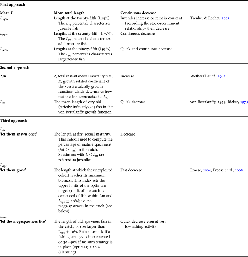
Total length (TL, cm) was measured for each specimen and a length–frequency distribution (LFD) was constructed after five-class smoothing in order to reduce the sampling noise and better approximate equilibrium conditions for successive analysis (Rosenberg & Beddington, Reference Rosenberg, Beddington and Gulland1988). The LFD and the main indices (minimum, maximum and median values) were computed overall and by fishing ground; LFD comparison was performed according to non-parametric tests (Kruskal–Wallis and Kolmogorov–Smirnov). Moreover, to analyse the fishing effects due to the history of exploitation on H. mediterraneus populations in the central–eastern Mediterranean, the following three approaches were considered (Table 1).
The three approaches and corresponding indices (referring to the gross catch length structure) employed for comparing fishing effects on silver roughy (Hoplostethus mediterraneus) stocks in the central–eastern Mediterranean Sea.
The first approach considered the capacity of the indices (1) mean length and (2) lengths at the 25th (L 25%), 75th (L 75%) and 95th (L 95%) percentile of the length distribution to provide information on fishery impacts (Trenkel & Rochet Reference Trenkel and Rochet2003; Rochet et al., Reference Rochet, Trenkel, Bellail, Coppin, Le Pape, Mahé, Morin, Poulard, Schlaich, Souplet, Vérin and Bertrand2005).
The second approach was based on the estimation of the ratio Z/K by the Powell–Wetherall plot (Wetherall et al., Reference Wetherall, Polovina, Ralston, Pauly and Morgan1987), as well as the asymptotic length (L ∞) of the von Bertalanffy growth function (vBGF); where Z is the total instantaneous mortality and K and L ∞ are the growth parameters of the vBGF. This method was implemented using the software Fisheries Management Science Programme (FMSP; Hoggarth et al., Reference Hoggarth, Abeyasekera, Arthur, Beddington, Burn, Halls, Kirkwood, McAllister, Medley, Mees, Parkes, Pilling, Wakeford and Welcomme2006), with the aim of investigating the total mortality among the unit stocks. For long-lived species, the shape analysis of the LFD within the Z/K ratio (from less than or around 1) and L ∞ are expected to increase and decrease, respectively, along the intensification of the exploitation rate (Pauly, Reference Pauly1984).
The third approach required the estimation of three length indices: the length at maturity (L m ‘Let them spawn’), the optimum length (L opt ‘Let them grow’) and the maximum length (L max ‘Let the mega-spawners live’) as suggested in Froese (Reference Froese2004). This author proposed a management scenario aimed at protecting juveniles and allowing the catch of only mature/large specimens (preferably avoiding the capture of the very old and large spawners, called ‘mega-spawners’). In the present case, L m and L opt were computed according to the empirical equation of Froese & Binohlan (Reference Froese and Binohlan2000), while L max was estimated as proposed by Formacion et al. (Reference Formacion, Rongo and Sambilay1991). These three indices were superimposed on the LFDs with the aims of observing a possible fishing-induced change in the length structure of the population. At the same time, a comparison of the proportions of mature, optimum and mega-spawner lengths in the gross catch among FGs was carried out, as suggested by Froese (Reference Froese2004).
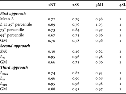
Having in mind the importance of determining the stock status in any fishery assessment (Pitcher, Reference Pitcher1995), the estimated indices were used in a diagnostic system for a comparison between the four stocks. Consequently, the indices were standardized among the four investigated FGs, considering the values in the pristine FG 4SL as ‘healthy’. The standardized indices of each approach were, hence, used as scores to quantify the overall degree of departure of the other stocks from the condition in FG 4SL (with a score of 1). In particular, the mean of the scores of each approach was computed, with the aim of highlighting whether the expected response of the indices to exploitation is satisfied (see Table 1).
RESULTS AND DISCUSSION
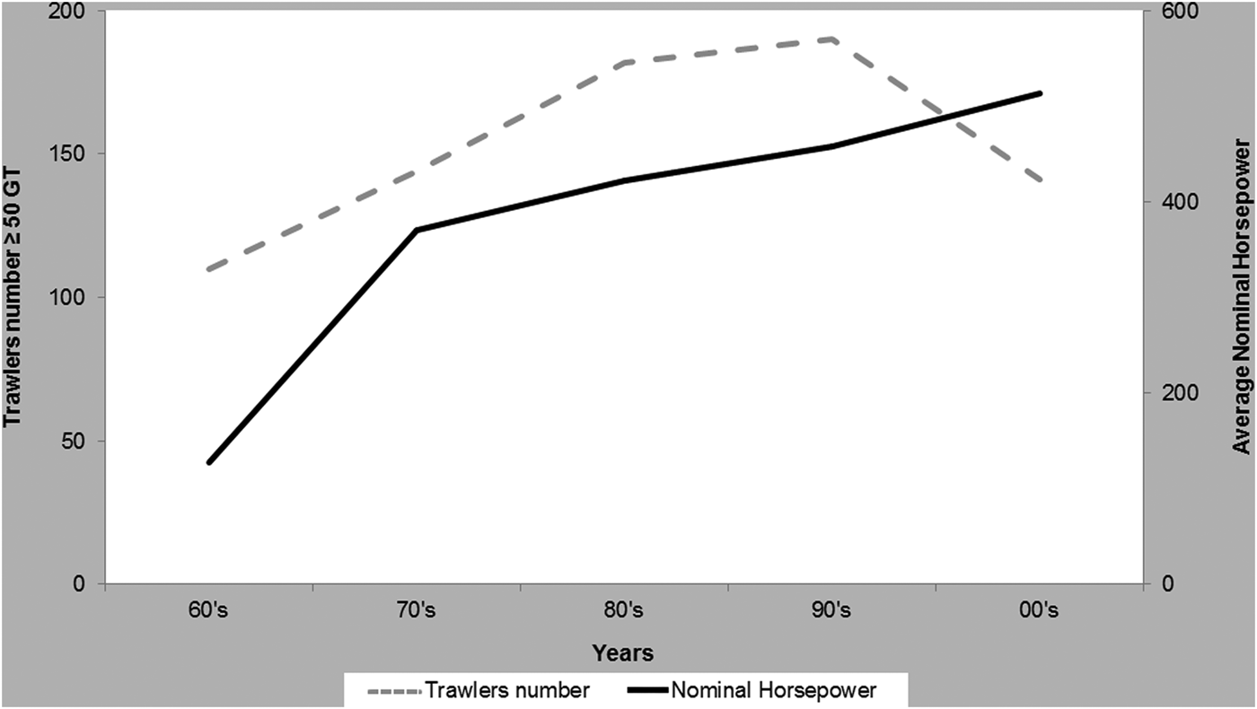
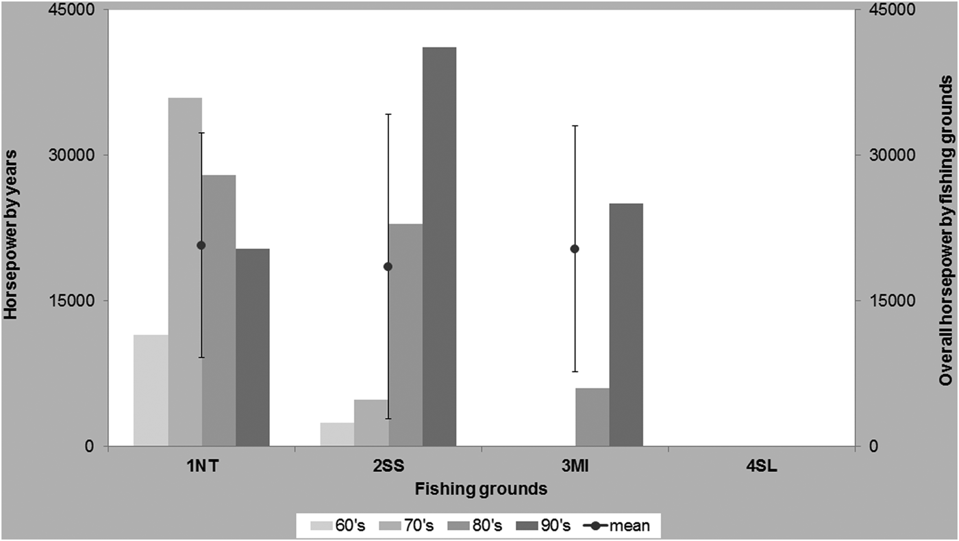
The evolution of the fishing capacity of the Mazara del Vallo trawler fleet, the most important in the central–eastern Mediterranean Sea, in the last 50 yr is shown in Figures 2 and 3. These indicate an increase in the number of trawlers from the 1960s until the end of the 1990s, with a reduction thereafter, although the mean horsepower has increased continuously, with a very rapid growth in the 1970s (Figure 2). The spatio-temporal distribution of the trawlers highlights the differences in fishing pressure among the FGs (Figure 3). During the late 1960s, about 110 trawlers exploited the offshore fishing grounds of the Strait of Sicily, the main fishing grounds for deep-water shrimps located off and around the Egadi Islands, off the northern coasts of Tunisia and along an ideal route connecting the bottoms off Cape Bon to Pantelleria and Linosa Islands (Scaccini et al., Reference Scaccini, Piccinetti and Sarà1970). During the 1970s and 1980s, the Mazara offshore trawler fleet increased in number, tonnage and power, and in the early 1990s reached the fishing grounds located off Lampedusa, Malta Islands and the Libyan coast, together with those on the eastern slope off Malta (Ragonese, Reference Ragonese1995). The progressive decrease in catch rates of deep-water shrimp and the absence of deep trawling in the eastern Mediterranean have led to some boats fishing around Crete, Cyprus and off the Turkish and Egyptian coasts since 2004 (Garofalo et al., Reference Garofalo, Giusto, Cusumano, Ingrande, Sinacori, Gristina and Fiorentino2007).
Evolution by decades of the fishing capacity (number of trawlers, broken line; average nominal horsepower, solid line) of the Mazara del Vallo offshore trawlers between 1960 and 2010.
Spatial–time distribution by decades of the fishing capacity (nominal horsepower) of the Mazara del Vallo offshore trawlers among the investigated fishing grounds (Northern Tunisia, 1NT; South of Sicily, 2SS; Malta Island, 3MI; South Levant, 4SL) between 1960 and 2000. Fishing activity in 4SL started in 2004. The overall mean and corresponding standard deviation by fishing grounds are superimposed.
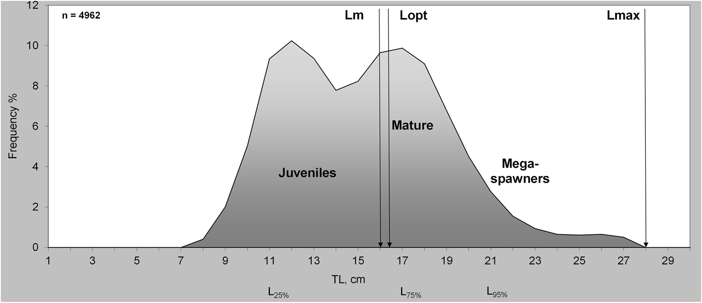
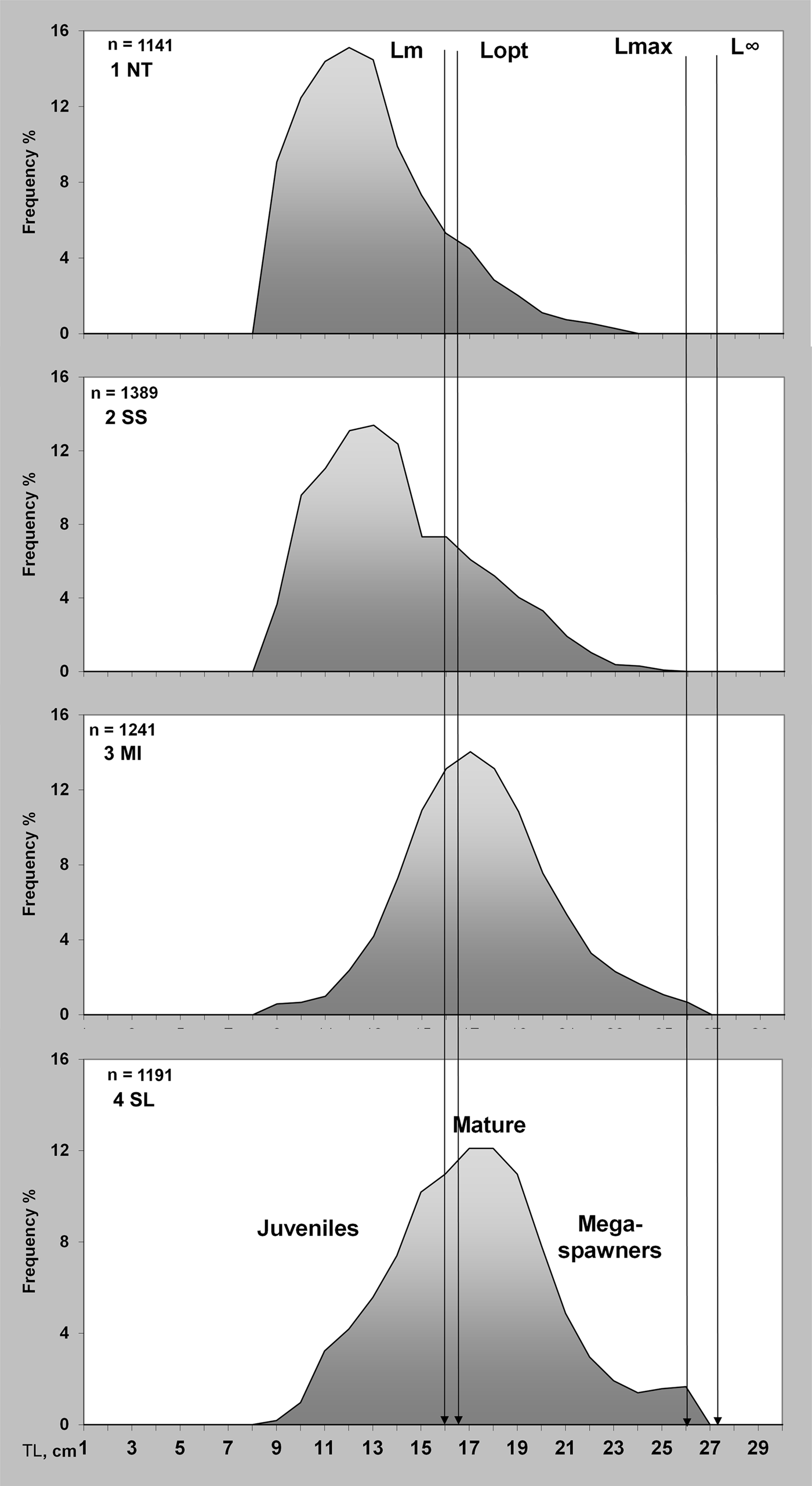
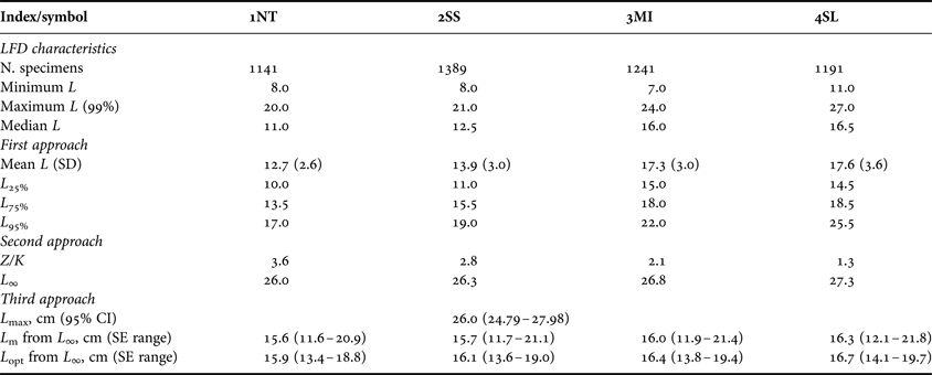
The overall LFD shape (Figure 4) was coherent with an almost discrete recruitment (first peak quite distinct), slow growth and piling-up effects (no further modes evident in the parental stock component). Assuming that the sampled catch accurately reflected the size structure of the stock, the occurrence of ~30% of specimens above the ‘Let the mega-spawners live’ indices (L max) would suggest an optimum exploitation level (sensu Froese, Reference Froese2004), notwithstanding that the large presence of juveniles clearly indicates a too precocious length at capture (i.e. growth overfishing problem). The judgment substantially changed when analysing both the LFDs shapes (Figure 5) and statistics separately for each FG (Table 2). LFD differences among the four FGs were significant (Kruskal–Wallis test, H = −14889, df = 3, P < 0.0001) among the median size and the overall LFD. The LFD pair-wise comparison revealed that the differences followed a western–eastern trend; in fact, no statistical differences (Kolmogorov–Smirnov test P > 0.05) were detected between 1NT and 2SS or between 3MI and 4SL.
Overall total length (TL) frequency distribution (cm) of silver roughy (Hoplostethus mediterraneus) sampled in the central–eastern Mediterranean Sea with the categories and part of the size indicators employed superimposed: length at sexual maturity, L m = 16.2 cm; optimum, L opt = 16.7 cm; maximum, L max = 28.0 cm; and percentiles (L 25% = 11.0 cm; L 75% = 17.0 cm; L 95% = 21.0 cm).
Total length (TL) frequency distribution (in cm) of silver roughy (Hoplostethus mediterraneus) in the four fishing grounds investigated (Northern Tunisia, 1NT; South of Sicily, 2SS; Malta Island, 3MI; South Levant, 4SL). L ∞ denotes the asymptotic length; for the other symbols see Figure 4.
Silver roughy (Hoplostethus mediterraneus) length–frequency distribution (LFD) characteristics and indices calculated in the four fishing grounds investigated (Northern Tunisia, 1NT; South of Sicily, 2SS; Malta Island, 3MI; South Levant, 4SL) among the different approaches. Key: N, number; min, minimum; max, maximum; median and mean length (L total, cm) of the length frequency distribution; SD, standard deviation; CI, confidence intervals; SE, standard error. See Table 1 for details.
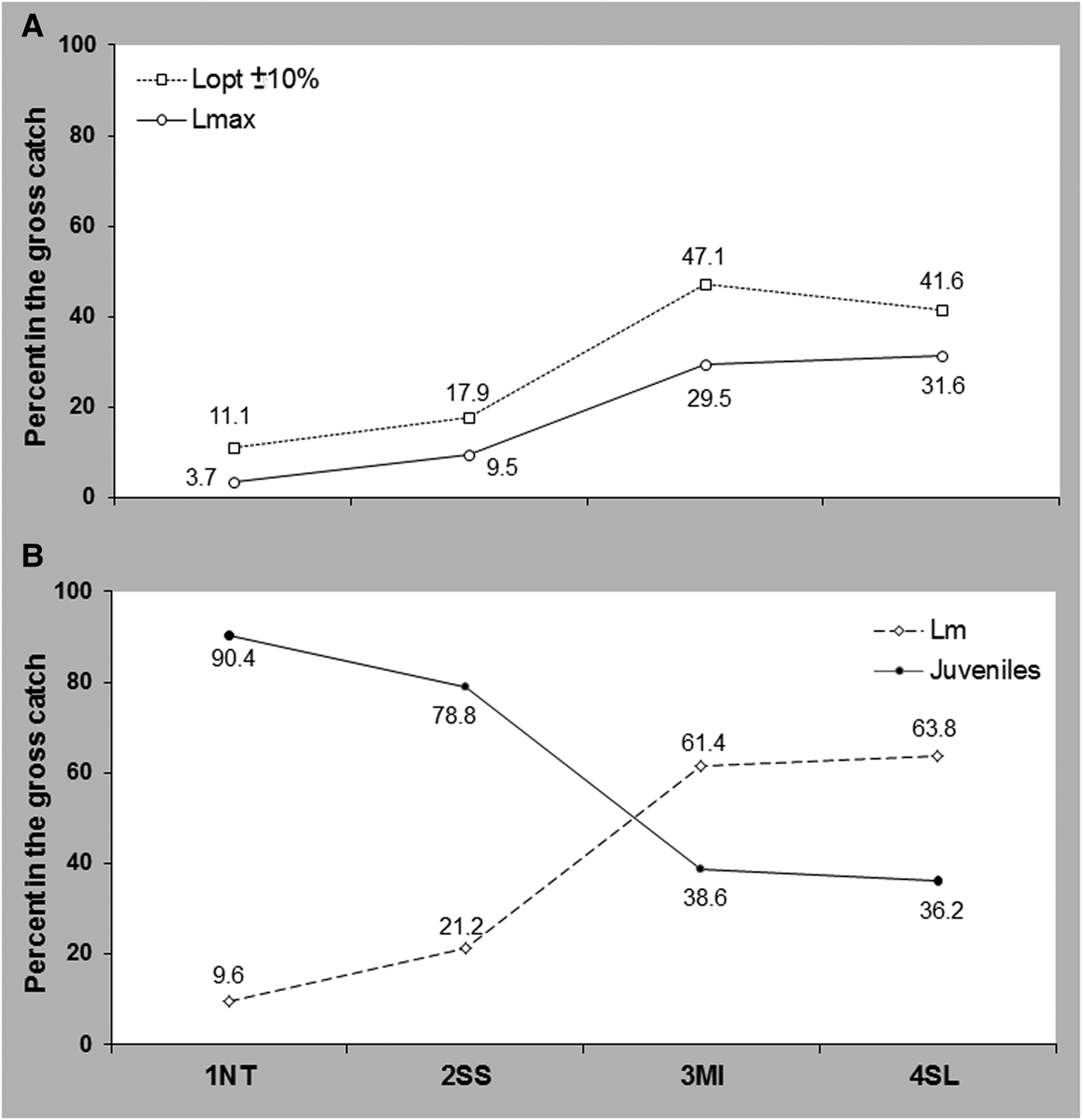
Evaluating the indices estimated for each FG, an increasing trend of L 25%,L 75% and L 95% and a decreasing trend of the Z/K ratio, in respect to a quite similar value of L ∞ (Table 2), indicates signs of stress that may be due to fishing impacts. In particular, the aforementioned life-history traits of H. mediterraneus, as well as the estimated low rate of growth for 25 of the 30 species of the genus Hoplostethus (mean estimated K = 0.15, SD = 0.06, among all estimations available for the genus; Froese & Pauly, Reference Froese and Pauly2002) indicate a different fishing pressure among the FGs in agreement with their evolution of the exploitation in space and time. Similar considerations concern the increasing percentage of mature specimens, the specimens at optimum length and the mega-spawners in the catch from 1NT to 4SL. In particular, comparing the FGs 4SL and 1NT (Figure 5) the percentage of mature specimens, the specimens at optimum length and the mega-spawners in the catch are about seven times, four times and nine times higher in the former than in the latter (Figure 6).
Silver roughy (Hoplostethus mediterraneus) percentages in the gross catch L opt ± 10%, L max (A), juveniles and L m (B), in the four fishing grounds investigated (Northern Tunisia, 1NT; South of Sicily, 2SS; Malta Island, 3MI; South Levant, 4SL).
Looking at the overall LFD, almost all indices used suggest an acceptable status of H. mediterraneus population in the central–eastern Mediterranean, whereas the analysis of the LFDs by FG showed potential signs of over-exploitation of the parental component in 1NT and 2SS. Similar conclusions can be highlighted by the diagnostic of the stock status reported in Table 3. The score obtained for each FG by approach showed a worsening trend from the 4SL to 1NT.
Comparison of the stock status among the four investigated fishing grounds (Northern Tunisia, 1NT; South of Sicily, 2SS; Malta Island, 3MI; South Levant, 4SL) for silver roughy (Hoplostethus mediterraneus). The indices by approach (Table 2) were standardized (ratio) using the value of the FG 4SL as baseline (‘healthy condition’), and then employed as a score: the higher the distance of the mean scores from 1, the worst the condition of the given fishing ground. Key: GM, geometric mean of the scores, see Table 1 for details of the indices/symbols.
There is evidence that the demersal fish assemblage in the central–eastern Mediterranean has been characterized by a different history of exploitation, with decreasing levels of fishing pressure from the central to the eastern side of the basin (Gristina et al., Reference Gristina, Bahri, Fiorentino and Garofalo2006). Although there are no quantitative data on the fishing effort, the evolution of the deep-water trawling fisheries of Mazara del Vallo from the 1960s to the first decade of this century (Scaccini et al., Reference Scaccini, Piccinetti and Sarà1970; Ragonese, Reference Ragonese1995; Garofalo et al., Reference Garofalo, Giusto, Cusumano, Ingrande, Sinacori, Gristina and Fiorentino2007) is consistent with the behaviour of the indices estimated in the present study. The evolution of deep-water trawling may be responsible for the fishing impact, that consists of a slow removal of the larger specimens, mainly in 1NT and 2SS, which have been affected by a longer and more intense exploitation. Although the shape of the detected length structures might be affected by sampling noise and bias (cf. Merrett & Haedrich, Reference Merrett and Haedrich1997) it is worth noting how, in a pristine or light exploitation condition, the LFDs in 3MI and 4SL resemble more the expected K-oriented shapes (i.e. Z/K < 1), whereas the LFDs in 1NT and 2SS look closer to an r-oriented shapes (i.e. Z/K > 1), (Pauly, Reference Pauly1984), in agreement with the different fishing patterns of the investigated fishing grounds.
The lower absolute presence of juveniles in the less exploited FGs is not in agreement with the discrete recruitment and the size-related depth segregation suggested by D'Onghia et al. (Reference D'Onghia, Tursi, Marano and Basanisi1998). In the present case, since the samples were gathered by trawlers operating in all months of the year and over the same depth range, a more suitable explanation could be that the investigated stocks follow a dome-shaped Ricker's stock recruitment relationship, which foresees a recruitment lower in the unexploited than in the exploited condition (Ricker, Reference Ricker1975), or the reported tendency of juveniles of deep-water species to reduce their co-occurrence with adults in order to optimise energy utilization through balanced partitioning of available resources (Gage & Tyler, Reference Gage and Tyler1991; D'Onghia et al., Reference D'Onghia, Tursi, Marano and Basanisi1998); i.e. a reduction of adults might favour closeness of juveniles to the bottom. Other factors such as a differential recruitment strength, a very critical consideration for long-living deep-water fish (Leaman & Beamish, Reference Leaman and Beamish1984; Cailliet et al., Reference Cailliet, Andrews, Burton, Watters, Kline and Ferry-Graham2001; Ragonese, Reference Ragonese2004), might have determined the observed differences in LFD that, in any case, cannot be recognized over a single year of observation.
Notwithstanding the lack of long-term observations, especially on recruitment, the present results support the idea that the parental component of the H. mediterraneus stock in the central–eastern Mediterranean may have been affected by trawling, even assuming a low catchability (sensu Alverson, Reference Alverson1971) in a commercial tow. Deep-water fishing activity may progressively shift the LFD towards younger fish (that do not have the same productivity per unit biomass as older fish; Beamish et al., Reference Beamish, McFarlane and Benson2006), as well as reducing the number of adults and, hence, losing their heterozygous traits (Smith et al., Reference Smith, Francis and McVeagh1991).
Consequently, although the exploited stocks of H. mediterraneus in the Mediterranean seem able at present to maintain an effective parental stock and recruitment levels sufficient to sustain the present standing stock (i.e. stocks show compensative mechanisms), the gradual loss of genetic components might determine, according to Beamish et al. (Reference Beamish, McFarlane and Benson2006) a longevity overfishing (such as in 1NT and 2SS), with unforeseeable long-term consequences.
CONCLUSION
The comparison of four silver roughly stocks by three different approaches has highlighted clear signs of overfishing in those fishing grounds characterized by a long history of a high level of exploitation. Consequently, to maintain the health of silver roughly and other slow growing fish caught in deep water shrimp fisheries, it is crucial to avoid exerting high fishing pressure for long periods on the fishing grounds. This clearly places in question, together with control of fishing effort, the adoption of specific technical measures to improve sustainability of deep water trawling, such as enforcing 50 mm diamond stretched mesh in the cod-end or establishing limited trawl lanes where the fishery is allowed (Dimeck et al., Reference Dimech, Kaiser, Ragonese and Schembri2012). This might contribute to ensuring the health of the silver roughly stock, as well as of other deep-sea species that are believed to be sustainable at low rates of exploitation. A final comment concerns the present deep limit of 1000 m for trawling established by the European Union (Council Regulation–EC–No 51/2006), which seems not precautionary, at least for the silver roughly stocks investigated in the present work.
ACKNOWLEDGEMENTS
We thank the captains (Pasquale Giacalone, Maurizio Giacalone, Antonino Genovese, Antonino Adamo) and all the crews of the commercial trawlers for their valuable collaboration in collecting the monthly samples. A special thanks and recognition is extended to all captains and colleagues who contributed to the extensive work during the semi-structured interviews. We are grateful to Dr Jim Ellis of the Centre for Environment, Fisheries & Aquaculture Science, Lowestoft, UK for his genuine interest in this paper.