INTRODUCTION
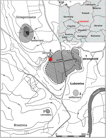
At the close of the Bronze Age, in stylistic phase HaB (1050/1020–810/800 BC) (Pare Reference Pare1998: 299; Trachsel Reference Trachsel2004: 316–317), a tendency developed in Central Europe towards the concentration of settlement and the formation of territorial communities of the little homeland type. This specific, barbarian variety of synoecism (from Greek synoikismós—incorporation) manifested itself through fortification of settlements and emergence of centers (strongholds) performing special economic and social functions in places marked by the highest concentration of environmental and cultural resources within a region. One of the largest centers of this kind in the northern part of Central Europe is the Łubowice stronghold near Racibórz in southwestern Poland. Occupying an area of more than 25 ha, it is situated on the upper Oder River north of the Moravian Gate—a crucial node on the routes linking the north and south of Central Europe (Figure 1). The stronghold was established on the west bank of the Oder, on a high promontory raising 20–25 m over the floodplain. The unique function of this site, as a settlement with permanent build-up of residential and economic nature and protected by monumental fortifications, has been confidently confirmed by many years of archaeological research (1954, 1962, 1970, 1972–1975, 1977, 1998–2007, 2018), carried out in several places within the stronghold, within the rampart relics themselves (Figure 3), and in the adjoining cemeteries (Chochorowski Reference Chochorowski1976, Reference Chochorowski1977).
Location of the Łubowice stronghold and accompanying open settlements (2, 4) and cemeteries (3, 5). The asterisk indicates the location of the trench explored in 1973–1974 and 1999.

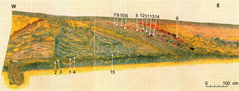
Fragment of a cross-section through the younger phase of the rampart, recorded in trench explored in 1999, with the locations of charcoal samples used in 14C analyses: 1–4 and 15—samples linked with the construction of the younger rampart; 5–14—samples linked with the destruction of the younger rampart.

The area of the settlement was most intensively occupied in stylistic phase HaB (Late Bronze Age). This is evidenced by abundant remains of dwellings and other features (over-ground houses, storage pits, kilns, cattle enclosures). The development was scattered, however, with a pattern of single households or small hamlets. The research at cremation cemeteries accompanying the Łubowice settlement has produced a similar picture of settlement intensification at the close of the Bronze Age. One of the cemeteries is situated near the stronghold’s rampart in the northwest part of the site (Łubowice site 5), while the other occupies a prominent hill further to the south, separated from the stronghold by a deep ravine (Brzeźnica site 3). The results obtained at the latter site, fully excavated between 2000 and 2007, are particularly telling. Almost all of more than 500 graves discovered there represent stylistic phase HaB, with merely a few showing characteristic traits of the pottery style typical of the early Hallstatt period (HaC), which in Central Europe marks the beginning of the Early Iron Age. Thus, it was no doubt at the close of the Bronze Age when the occupation of the Łubowice settlement itself and the adjacent parts of the Głubczyce Plateau covered with fertile chernozem soils of loess origin (Mierzwiński Reference Mierzwiński1994: figure 19, map 5) reached its peak. These processes reflected a distinct growth in the demographic potential of local communities, and were accompanied by phenomena linked with social mobilisation, making Łubowice the most important settlement and economic center in the region. One result was an effort to fortify the most intensively occupied part of the promontory. Boosting security, which can be seen as an important factor in building social-political prestige, the fortifications invested those inhabiting the stronghold with a special status.
ARCHAEOLOGICAL INVESTIGATIONS
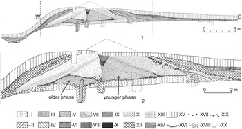
However, the fortification system of the Łubowice stronghold developed over time rather than as a one-off undertaking, since it was a derivative of processes such as demographic growth, settlement concentration, entrenchment of the defensive function of the site, as well as a gradual rise of its military and prestige positions. As an exemplification of the “defensive strategy of survival” (Vencl Reference Vencl1983: 289–290; Chochorowski Reference Chochorowski and Gediga1989: 93–94), this system also reflected the tightening connection between the stronghold’s population and the territory it exploited. The stratigraphy of the fortifications has been particularly comprehensively investigated in the northwestern part of the stronghold (Figure 2). Initially, in the older phase of development, the defences consisted basically of a fence built of posts approx. 20 cm thick set at intervals of approx. 0.5 m, which were linked with a plaiting wall. The defensive value of the structure was enhanced only by a low—probably no higher than 1–1.2 m—earthen embankment which reinforced and stabilized the fence from both sides. What is impressive, however, is the scale of this undertaking, as the fortifications built in this manner provided a defensive perimeter of about 1800 m. After some time, a general reconstruction was undertaken. As a result, a monumental earthen rampart crowned with a palisade with a platform for defenders was built, representing the younger—and much more developed—phase of the fortifications. Some truly significant socio-political reasons must have emerged at that time to mobilize the residents of the stronghold—and probably also the groups living in its vicinity—to undertake such an extensive construction activity, requiring an immense workload and efficient organization.
Northern profile of a cross-section through the rampart, performed in 1973–1974 in NW part of the stronghold: I—primary humus; II, III, V, VI—layers of the older phase of the rampart; IV, VII–IX, XVI—layers of the younger phase of the rampart; X—layer of silt on the bottom of the moat; X–XII, XIV—destruction layers of the younger rampart; XIII, XV—medieval and modern layers; XVII—stones; XVIII—silts; XIX—charcoal; XX—outlines of posts interpolated on the profile of the trench.

Given the length of the line of defences erected around the settlement (about 1800 m), the construction of the younger phase of fortifications required using approx. 4200 oaken posts, each 5–6 m long and 20–30 cm in diameter (only for the palisade and the supports for the platform for defenders), and moving approx. 40,000 m3 of earth weighing roughly 56,000 tonnes for the rampart. The rampart was on average 15 m wide at the base, and its height in the investigated places was 3–3.5 m. Originally, it must have averaged at least 4–5 m in height. It cannot be told now how high the palisade and platform reached above the rampart’s top. Nevertheless, the elevation difference between the top of the fortifications and the dry moat could have reached even 7–8 m (depending on the place), which surely made the entire structure a formidable defence and imparted it with a psychologically important, monumental nature. The rotting of the upper elements of the timber palisade (as well as the platform) resulted in the need for it to be renovated (or possibly rebuilt). Traces of two such reconstruction episodes in a sequence have been identified in the investigated section of the fortifications. One can thus assume that in their monumental form the fortifications were used over a time span of two or three periods of natural decomposition of timber material (40–60 years in total).
The results of archaeological research have proven beyond any doubt that the timber elements of the youngest fortifications were destroyed in a violent fire which engulfed the wooden structures along the entire line of defences. The timbers must have been well-preserved at that time, since traces of very intensive fire (along with many fragments of charred timber) could be identified in the destruction layer covering the inner slope of the earthen rampart (Figures 2–3). The deposition of burned debris mainly on the inner slope of the rampart further confirms the presence of the platform for defenders. The fact that partly burned elements of timber fortifications collapsed primarily towards the inside of the stronghold stems from sliding of the massive, partly burned platform down the slope under its own weight. The destruction layer deposited on the slope contained pieces of charred oak beams, numerous concentrations of tiny charcoals, and lumps of burned clay (daub). The fire must have been very intense, as evidenced by layers of clay which was burned in situ in the vicinity of charred pieces of timber. Lumps of burned daub that rolled down the slope were found at the bottom of the moat, within laminated deposits which these lumps mechanically disturbed falling into them. This could hypothetically indicate that the moat must at that time have been filled with rainwater at the bottom (possibly during autumn rains), which even further emphasize the violent nature of the fire. It is worth noting here that the laminated deposits at the moat’s bottom were not particularly thick (around 10 cm). Taking into account how easily uncovered loess clay can be dissolved by rainwater, one has to accept that after their construction was complete, the fortifications of the youngest phase did not function for particularly long. The recorded cross-sections do not show any traces of cleaning the moat or deepening of its bottom, which are generally common in clay-earth fortifications of this kind (Chochorowski et al. Reference Chochorowski, Krąpiec, Skoryj and Skrypkin2014; Figure 4). The burned debris layer at the bottom of the moat also contained sparse but characteristic ceramic material, bearing stylistic traces which in this region are typical rather of the HaC period. The results of archaeological investigation of the stronghold itself and of the accompanying settlement complex indicate that after the discussed episode the fortifications were not rebuilt, and the next traces of occupation come only from the medieval period (13th–15th century AD).
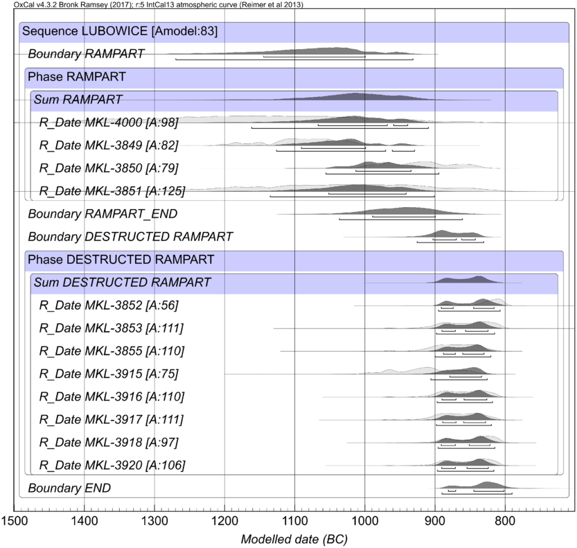
Modeled calendar age BC placements of the 14C-dated charcoal samples from the younger rampart of the fortified settlement at Łubowice. The 14C dates are listed in Table 1.

MATERIAL AND METHODS
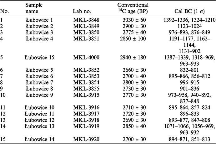
The basic research problem affecting the evaluation of the civilizational role of the Łubowice stronghold is the determination of its chronological frameworks, especially with respect to the younger, monumental phase of fortifications. From the perspective of the analysis of historical processes, of particular importance is the determination of the moment of the stronghold’s destruction. Towards this end, a series of radiocarbon (14C) analyses was performed using selected charcoal samples obtained from particular stratigraphic sequences within the younger rampart, collected from the trench explored in 1999 (Table 1, Figure 3). First, samples collected from stratigraphic levels chronologically corresponding with the construction of the monumental (younger) fortifications were analyzed (samples Łubowice 1–4). They originated from the lower section of the analyzed sequence (Figure 3) and were linked with the following contexts:
-
Ł1—thin layer of charcoal (possibly relics of a hearth) lying on the buried humus layer, near the palisade trench;
-
Ł2—fill of a hole left by a rotten palisade post within the palisade trench;
-
Ł3—clay-humus fill of the palisade trench, which stabilized the posts;
-
Ł4—remains of a hearth lying on a thin layer of loess clay which formed during the digging of the palisade trench.
List of 14C dates for samples from the Łubowice fortifications (see Figure 3 for locations of the samples).

To verify the results, an additional sample collected from the bottom part of the rampart was analyzed (Ł15). The material collected from the mentioned contexts consisted of small, or even highly fragmented pieces of charred wood, with pieces large enough for species determination originating only from oak.
To determine the moment when the fortifications were destroyed, samples originating solely from the layer connected with their destruction, recorded on the slope of the rampart, were analyzed (Łubowice 5-14). They undoubtedly originated from the palisade and the platform for defenders corresponding with the last stage of the fortifications’ reconstruction and functioning. Among the selected pieces of charred oak wood from the destruction layer, larger fragments certainly originating from half-timbers and lathes were identified. Despite the fact that the destruction layer deposited on the rampart’s slope was basically morphologically homogenous within the investigated area (Figure 3), charcoal samples were diversified by collecting them from different levels within this layer. From the bottom up, these are samples from the bottom of the destruction layer (Ł5 and Ł6), followed by a series of samples taken from large pieces of charred timber, sometimes with more than a dozen tree rings, in the middle sections of the destruction layer (Ł9—Ł14). Only two samples, Ł12 and Ł14, provided sequences originating from layers close to the outermost layers of the tree trunks. Two samples in the discussed sequence (Ł7 and Ł8) originated from the surface of the destruction layer and were collected from structures revealing traces of washing out by rainwater. All the samples from the destruction layer originate from narrow-ring or medium-ring oak trees.
All samples were dated using the conventional liquid scintillation spectrometry (LSC) 14C dating technique at the Laboratory of Absolute Dating in Skała and Kraków, Poland (MKL lab code). Charcoal samples were chemically pretreated with the acid-alkali-acid (AAA) method. After drying the sample, further procedures included a standard synthesis of benzene from carbonized samples (Skripkin and Kovalyukh Reference Skripkin and Kovalyukh1998). Measurements were carried out with a Hidex 300 SL spectrometer (Krąpiec and Walanus Reference Krąpiec and Walanus2011). All dates were calibrated using the OxCal 4.2 calibration program (Bronk Ramsey and Lee Reference Bronk Ramsey and Lee2013) on the basis of the IntCal13 calibration curve (Reimer et al. Reference Reimer, Bard, Bayliss, Beck, Blackwell, Bronk Ramsey, Buck, Cheng, Edwards, Friedrich, Grootes, Guilderson, Haflidason, Hajdas, Hatte, Heaton, Hoffmann, Hogg, Hughen, Kaiser, Kromer, Manning, Niu, Reimer, Richards, Scott, Southon, Staff, Turney and van der Plicht2013). The chronology of the rampart remnants was determined based on a model calculated using the OxCal procedures (the Sequence command). The beginning and end of the phase were determined using the Boundary Begin/Boundary End commands, and its duration was calculated using the Phase function (Bronk Ramsey Reference Bronk Ramsey2009).
RESULTS
By comparing the samples originating from the time when the monumental fortifications were being erected and those originating from layers covering the slope of the rampart, which formed as a result of the destruction of the wooden structure, a chronological model was developed which assumed two chronological phases, corresponding with these two sequences. The obtained results have shown that the overall agreement index for 14C dates and stratigraphic data (Ac=41.8%) falls beneath the threshold value allowing for a model to be considered correct (Ac=60%). This was due to three 14C dates (MKL-3848, 3919, and 3854), which were clearly older and stood out from the rest. In the case of these three dates, the discrepancy probably stems from the fact that they originated from inner layers of the trunks, which in narrow-ring wood may result in an age difference of even more than 100 years. With these three dates removed, the resulting chronological model has an overall agreement index of Ac=83%, much above the threshold value (Figure 4).
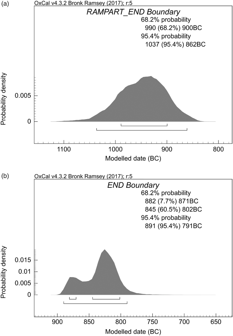
The chronological model indicates that the building of the monumental fortifications protecting the Łubowice settlement should be dated to 990–900 cal BC (68.2%, Figure 5A), which indeed falls within stylistic phase HaB (1050/1020–810/800 BC). The ultimate destruction of fortifications falls to the 9th century, with 845–802 cal BC (60.5%, Figure 5B) as the range with the highest density of posterior probability. Thus, this fact should be linked with the turn of phases HaB and HaC and the very beginning of HaC (HaC1 = 810/800–720 BC) (Pare Reference Pare1998; Trachsel Reference Trachsel2004). Such a chronology of the construction, and in particular the destruction of the Łubowice fortifications fully agrees with observations made in the cemeteries associated with the stronghold, where burials representing the stylistic sequence typical of HaC are only minimally represented.
Probability distribution for calendar year values for the phases of construction (a) and destruction (b) of the younger rampart.

One should not forget, however, that age estimations obtained from charcoal (especially from highly fragmented charcoal) tend to be older than the expected historical dating. This applies in particular to the samples linked with the construction of the younger rampart. The extent of this kind of “archaization” is difficult to determine though, and it varies highly from case to case. Nevertheless, in this particular case it seems that the moments of the construction and destruction of the youngest fortifications must be slightly younger than the time indicated by 14C determinations, i.e. 990–900 cal BC and 845–802 cal BC, respectively. This is suggested by the nature of the dated samples, only some of which were larger pieces possibly originating from outermost fragments of large timbers; for none of the samples was it possible to unambiguously prove their origin from the outermost layers of a tree trunk. The extent of this chronological correction cannot be determined.
DISCUSSION
Formulated as early as in the 1970s, concepts concerning the place of the Łubowice stronghold in the historical process posited (Chochorowski Reference Chochorowski1977: 117–119) that its fortifications were erected and functioned at the close of the Bronze Age, i.e. during stylistic phases HaB2–HaB3 (950/920–810/800 BC) (Pare Reference Pare1998: 299; Trachsel Reference Trachsel2004: 316–317). The monumental reconstruction was linked already with the beginnings of the Iron Age, with the stronghold at Łubowice regarded as a significant node in the settlement structures that in the upper and middle Oder basin took their final shape during stylistic phase HaC (Gedl Reference Gedl1973: 72–73; Chochorowski Reference Chochorowski and Śliwa2005: 492–493). The beginnings of the Iron Age in southwestern Poland was a period marked with deep cultural transformations referred to as the hallstatisation process. In this region, the term came to be synonymous with the beginning of a new era, the spread of iron metallurgy, and at the same time with deep social transformations, with the crystallisation of new elites as their most notable consequence. These elites manifested their social and economic position in settlements by surrounding their dwellings with additional fortifications (Grześkowiak and Kopiasz Reference Grześkowiak and Kopiasz2003: 195; Bugaj and Gediga Reference Bugaj and Gediga2004: 225–232) and turning them into residential complexes of “courtly” nature, and in cemeteries by burying their dead in tombs richly furnished with weapons and luxury objects (Madera Reference Madera1999: 231–246; Gediga Reference Gediga2012: 415–418).
According to the original concept, the violent destruction (burning down) of the Łubowice stronghold took place later, in the period marked by the predominance of Hallstatt cultural patterns (Chochorowski Reference Chochorowski1977:117–119), at some point during the Hallstatt period (which today means 810/800–520 BC—Trachsel Reference Trachsel2004: 317–319). According to the then understanding of the chronology of the Early Iron Age in Poland, this moment was correlated with the close of HaC, i.e. around 550/500 BC (Gardawski and Woźniak Reference Gardawski, Woźniak and Hensel1979: 24). In the absence of other clues, the destruction of the Łubowice stronghold was linked with catastrophic results of the so-called Scythian invasions, a wave of military infiltrations by groups of nomads using Scythian-type weapons. These raids marked the westernmost episode of the process of the nomads taking control over quasi-steppe areas within the Carpathian Basin (Hungarian “puszta”). In Central Europe, these raids reached through Transdanubia, to Moravia, the Moravian Gate, to the left-bank Oder basin, as far as the Lower Lusatia region on the middle Oder River at the Polish-German border (Chochorowski Reference Chochorowski2014: 32–43). Today, the chronological frameworks of “Scythian invasions” in Central Europe are determined by the destruction by the nomads of the Smolenice stronghold in southwestern Slovakia on the one hand, and of the Wicina stronghold in the middle Oder basin in western Poland, on the other. The former succumbed to destruction in the last quarter of the 7th century BC (Chochorowski Reference Chochorowski2014: 36–41) and the latter in 570–560 BC. Of paramount importance for credible dating of these events is especially the precise determination of the moment when Wicina was destroyed. Extensive dendrochronological research (over 1600 samples) demonstrated that this took place shortly after 571 BC (Krąpiec and Szychowska-Krąpiec Reference Krąpiec, Szychowska-Krąpiec, Jaszewska and Kałagate2013: 371–374). Before the 14C analyses presented here were available, it was therefore believed (Chochorowski Reference Chochorowski1976: 70–71, Reference Chochorowski2014: 36–41) that the destruction of the Łubowice stronghold—situated near the Moravian Gate, at a route used by the nomads from the steppe areas of the Great Hungarian Plain—must have been chronologically associated with one of these episodes, i.e. dated between 625/600 and 570/560 BC.
CONCLUSION
The new dating of the moment when the Łubowice fortifications were burned down to shortly after 845–802 BC (around 800 BC?) places this event within historical processes which reshaped the cultural picture in much of Central Europe at the dawn of the Iron Age. The fall of the stronghold should now be seen as one of the symptoms of hallstattisation. The spreading of a new, Hallstatt cultural model was associated with deep changes in social structures (Gediga Reference Gediga and Gancarski2010: 426–427). These processes could have locally increased political (military) tensions, resulting, among other things, in destruction of some of the earlier centers, such as the stronghold at Łubowice. The process of hallstattisation of Late Bronze Age groups outside the range of the proper Hallstatt culture from circum-Alpine areas was thus much deeper than it was quite commonly assumed. It was by no means limited to the adoption of certain more or less attractive elements of material culture, instead reaching deeply into socio-political structures, creating—probably not without resistance and involving actions of military nature—a new social order and a system of “ownership”. The results of the 14C analyses, which altered considerably the view on the time when the Łubowice stronghold was built, and particularly when it was destroyed, provide a foundation for a new, previously often underestimated perspective on one of the most crucial threshold moments in the late prehistory of Central Europe.
ACKNOWLEDGMENTS
This work was partly supported by the Faculty of Geology, Geophysics and Environmental Protection, AGH University of Science and Technology, grant No. 16.16.140.315 (M.K.). Special thanks are due to the reviewers and editor for substantive comments.