Paris is a city famous for its art worlds. The city has a long history of nurturing artistic communities who created new styles, started cultural movements and pushed the boundaries of visual representation. Paris's ‘city of art’ moniker is, however, associated far more with its nineteenth- and twentieth-century histories than with its eighteenth-century one. It is Impressionism, Dadaism and Cubism – not Rococo and Neoclassicism – that have really defined Paris's popular image as a city of art. Yet this modern slant to Paris's artistic reputation is not the whole story. After all, it was the early modern city that actually secured the French capital's artistic dominance. With the founding of the French Academy of Painting and Sculpture in 1648, Paris began its global artistic ascent throughout the second half of the seventeenth century. By the eighteenth century, Paris had resoundingly superseded Europe's other cities, even challenging Rome as the centre of the contemporary European art scene: its Academy and public exhibition culture became models to emulate, and its artistic productions were the pinnacle of style for Europe's artists and collectors. If there was a city of art in eighteenth-century Europe, it was without doubt Paris.
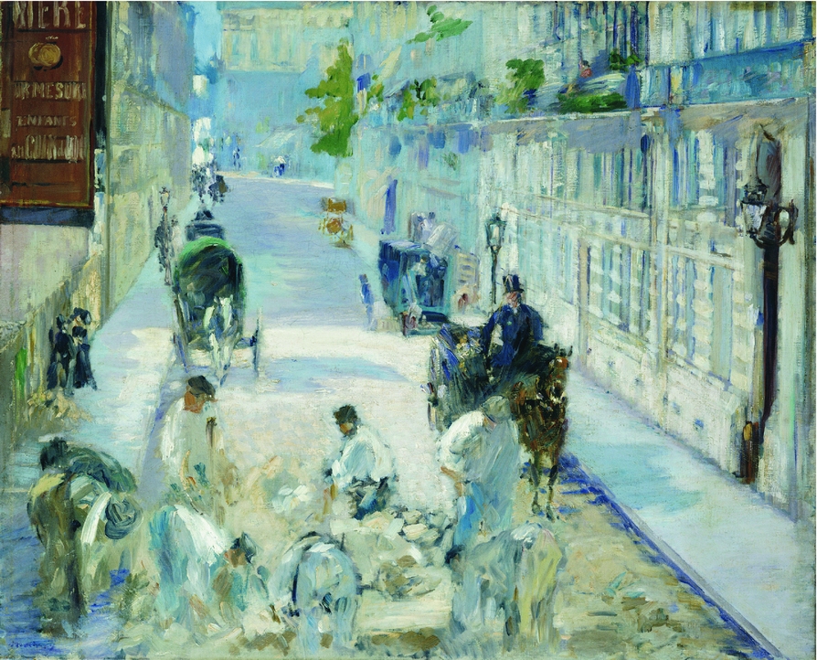
The modernist bias to Paris's artistic reputation is not then a historical issue, but rather a historiographical one, explained not by what Paris was in these different eras, but by how it has been narrated by art historians. For while studies of nineteenth- and twentieth-century French art have made Paris itself a crucial part of the art world's story, in art histories of the eighteenth century, the city rarely gets a mention.Footnote 1 For modernists, the historiographical interest in urban space was perhaps unavoidable, given that modern artists themselves made the city such a fundamental part of their art, paying rapt attention to the rapidly developing city and to their own places within it. Édouard Manet's Rue Mosnier with Road Menders Seen from his Studio on Rue de St Petersbourg (Figure 1) offers a familiar instance of such engagement: a street scene of quotidian activity and urban development witnessed from his studio window. In works like this, Paris's modern artists turned their experiences of local city life into one of the period's most persistent artistic preoccupations.
Édouard Manet, Rue Mosnier with Road Menders Seen from his Studio on Rue de St Petersbourg, 1878. Oil on canvas, 65.4 x 81.5 cm. Private Collection, Switzerland. Photo: © Christie's Images / Bridgeman Images.

One effect of modernist art historians’ city-oriented focus has been a deep understanding not just of how artists represented the city, but of how they inhabited it.Footnote 2 We know where Claude Monet and Pierre Auguste Renoir lived and kept studios, which streets Gustave Caillebotte walked down, where Edgar Degas and Henri de Toulouse-Lautrec ate and drank and which of these artists were neighbours. Indeed, we know it all so well that even non-art historians recognize the artistic associations of neighbourhoods like Montmartre, Montparnasse or Saint-Lazare (the latter home to Manet's Rue de St Petersbourg studio). Art historians have retrieved such an evocative sense of these urban artistic communities that exploring their neighbourhoods has become a popular touristic pastime. Countless guidebooks and tours invite visitors to rediscover modernist artists’ homes and studios, to walk in their footsteps and catch a glimpse of the city they experienced.Footnote 3
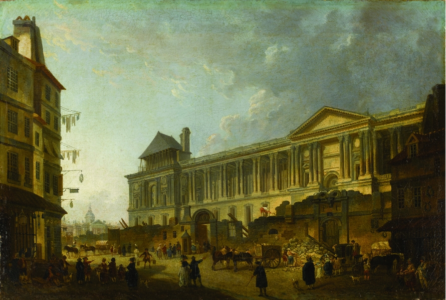
By contrast, when it comes to the eighteenth-century art world, our picture of the city and its role in artists’ lives is comparatively sparse. Paris did not play the same role as subject matter that it would in the following century, at least in terms of the volume of images. While art was still governed by academic art theory, street scenes of the contemporary city were not conventional subjects. Most painters were admitted to the Academy as history painters, the genre privileged far above ‘lesser’ genres such as landscape or still life. The Academy also restricted its artists to working only (at least in theory) in the genre to which they had been admitted, so the only artists who might paint city views or street scenes were landscapists, architecture painters or genre painters. Nevertheless, the eighteenth century was the moment when that ubiquitous ‘Paris picturesque’ imagery started taking form, when cityscapes and scenes of street life began developing into that Parisian genre. Pierre-Antoine Demachy was one artist who took an early interest in Paris's changing urban fabric. In works like Clearing the Louvre's Colonnade (Figure 2), Demachy depicted his city over and over again, capturing projects of urban transformation, in this instance, the demolition of a row of buildings that once hid the palace from the street. Demachy's works are often considered architecture paintings – depictions of monumental buildings – but Demachy's painting of Rue du Petit-Bourbon is also a representation of city life. A hundred years before Manet's roadworkers on Rue Mosnier, Demachy was capturing labourers’ efforts and the quotidian spectacle they afforded: workmen knocking down walls, passers-by pausing to appraise the developments, while washing hangs drying across the street. Moreover, like the view from Manet's studio, this was also a moment witnessed by a local inhabitant. Born just around the corner, Demachy lived his entire life in this neighbourhood and moved into the Louvre itself only a couple of years before making this painting.Footnote 4
Pierre-Antoine Demachy, Clearing the Louvre's Colonnade, 1772. Oil on canvas, 76 x 131 cm. Musée du Louvre, Paris. Photo: © RMN-Grand Palais [Musée du Louvre] / Stéphane Maréchalle.

Yet despite such artistic engagement, eighteenth-century Paris – as a lived place – has been neglected art-historical terrain. Notwithstanding some exceptions that draw urban spaces or activities into the art-historical narrative, the city tends to remain a backdrop.Footnote 5 And while the question of how artists inhabited the city may be de rigueur for modernists, it has rarely been asked, let alone answered, for Paris's earlier artistic generations. Important contributions have begun this work with tantalizing but specific investigations. Many monographic studies have traced the homes of individual artists and revealed personal connections to the city.Footnote 6 There have also been studies of key sites – such as the Louvre, the Gobelins tapestry factory and the Left Bank printmakers – which have provided crucial insights into artistic sub-communities inhabiting these spaces.Footnote 7 What is still missing, however, is a sense of the broader geography of the art world at this moment.
This article seeks to push the city to the foreground of eighteenth-century French art. Through an approach connecting art history and urban history, my intention is to use maps of eighteenth-century art worlds to consider what the city might reveal about the lives of its artists and what those communities might reveal about the history of the city. Drawing extensively on a recent digital mapping project exploring these issues – Artists in Paris: Mapping the Eighteenth-Century Art World – I attend to the sources that both permit and challenge such spatial and demographic inquiries, while interrogating the art-historical and social-historical insights to be gleaned from establishing an empirical ground-map of where artists were living and working. Beginning with an overview of the digital mapping project, its objectives, sources and scope, this article goes on to examine three different views of the city's art world: a survey of the neighbourhoods of the Academy's artists across the century; a comparative look at the Guild's artists in the 1770s; and a wider worldview of Parisian artists living abroad to encompass a more global sense of a local urban community. Exploring the geography of Paris's artistic communities in this way raises intriguing questions about what, or who, constitutes a city's art world, about where the limits of one city's artistic community should be drawn and about how the technologies of digital mapping might inform new understandings of artistic sociability and art production.
Digitally mapping the eighteenth-century art world
Where in Paris did eighteenth-century artists live and work? Which neighbourhoods formed the cultural geography of the art world in this period? And did that geography change over the century? These are some of the initial questions that prompted the digital mapping project, Artists in Paris: Mapping the Eighteenth-Century Art World, and its open-access interactive research tool (www.artistsinparis.org).Footnote 8 Mapping the addresses of hundreds of artists active during this period, Artists in Paris offers a new cartographic model of the art world, answering many of the project's initial questions, and raising additional avenues of inquiry in the process. As many of the findings in this article are drawn from Artists in Paris, it is important to give an overview of this project and the sources used in its research and development in order to suggest its scope and limitations, and to establish the evidentiary base upon which conclusions are drawn.
Mapping the art world must begin with some fundamental parameters, not least, a determination of whom to map. In its broadest sense, Paris's art world was a vast heterogeneous network of makers, suppliers, exhibition spaces and commercial outlets. While other notable digital mapping projects like Mapping Art Markets in Europe, 1500–1800 (www.artmarkets.eu) and Artl@s (www.artlas.ens.fr) have focused on commercial networks and exhibitions, Artists in Paris looks instead to the social lives of artists.Footnote 9 Paris's art makers could still be envisaged as a diverse group, comprising painters, sculptors, engravers, goldsmiths, tapestry weavers, ceramicists, furniture makers, clock makers, jewellers and many other creators of the eighteenth century's richly adorned interiors. Currently, Artists in Paris focuses on a more refined sub-section, including only artists who fitted the definition of that concept established by the Academy, namely painters, sculptors and engravers. Yet even adopting this definition, Paris's art world is still, archivally speaking, an elusive community. To practise as an artist in pre-Revolutionary Paris, it was a legal requirement to be a member of one of two institutions: either the Académie Royale de Peinture et de Sculpture, the elite Royal Academy (1648–1793); or the Communauté des Maîtres Peintres et Sculpteurs, the much older city Guild (1391–1776).Footnote 10 The Academy's artists are now far better known than their rivals at the Guild: only a handful of Guild artists have recognizable names or even attributable artworks, while the majority of French art history has been written about academicians. Nevertheless, an ideal map of the Paris art world would include both communities, but unfortunately the historical sources make this far from straightforward.
The Academy's membership records were kept fastidiously and archived carefully, at least from 1675, when the institution began printing an annual membership list, arranging all its artists by rank and order of admission, with their addresses noted beside their names. At the start of each year, the Academy's concierge pasted a copy into a special ledger, eventually creating a membership directory containing 75 years of academicians’ addresses.Footnote 11 Unfortunately, the custom inexplicably stopped after 1751, but by this time, academicians’ addresses were being printed annually in the Almanach Royal (or Almanach National following the Revolution), which continued right up to the Academy's disbanding in 1793.Footnote 12 Using this data, it has been possible to map the addresses of Paris's academic artists comprehensively, with very few exceptions, for a period of nearly 120 years.Footnote 13 Meanwhile, the Guild's records are far more sporadic. Only a handful of membership lists across the period in question have been located and address information was only intermittently recorded.Footnote 14 Due to the substantial gaps in these archival records, a comparable comprehensive mapping of Guild artists across the century has not been possible, so at this stage Artists in Paris focuses on the artists of the Academy.
On the one hand then, Artists in Paris maps only a fraction of the art world and presents a picture of an artistic community comprised only of the city's most elite artists. On the other hand, there are caveats to these limits and advantages to this focus. Perhaps most importantly, working with a relatively complete dataset makes for more meaningful demographic analysis: we can establish a comprehensive map of this artistic community and its development over more than a century, observing its evolution as an urban professional population from the reign of Louis XIV up until the French Revolution. Moreover, despite its limits, the dataset is still substantial in size and variety. The database contains biographical entries for nearly 500 artists, with addresses for every year of their careers, coming to a total of almost 11,000 geolocated address markers. While united by their academic membership, there is significant professional variety in this group, not least due to the media or genre in which the artists practised, which often connected them with different suppliers, patrons or commercial spaces. On the website, the artist's profession (e.g. sculptor, history painter, portraitist, landscapist, engraver, etc.) is colour-coded in order to give a sense of the Academy's shifting composition and to trace sub-communities of trades across the city. Finally, it should also be noted that while the Academy's artists were the city's ‘elite’ in terms of institutional hierarchies, this did not always correlate with social or economic privilege. Some academicians lived luxurious lifestyles and moved in elite social circles, but others were barely making ends meet. Thus, even within this sub-section of the art world, we are still dealing with a degree of social diversity.
Artists in Paris has privileged the demographic clarity of a complete dataset in its focus on the Academy's artists. But for comparison and some sense of the broader art-world geographies, this article also takes a look at the Guild. While the sources do not permit a systematic mapping of Guild artists’ addresses over the entire period, it has been possible to retrieve and map addresses for a single year. In 1776, Abbé Lebrun published a trade directory – the Almanach historique et raisonné des architectes, peintres, sculpteurs, graveurs et cizeleurs – including all the names and addresses of the Guild's current members.Footnote 15 Mapping this one complete year, we find a snapshot of the Guild community and some valuable insights into the bigger picture of Paris's art world at least at this single moment in the city's history.
Digital mapping offers many analytical advantages for understanding Paris's artistic communities, but for a historical project the approach also brings challenges for the mapping process itself. First and foremost, Paris has undergone substantial urban transformation since the eighteenth century, particularly during Baron Haussmann's extensive reconstruction and public works programme in the Second Empire (1852–70). If eighteenth-century addresses are plotted directly onto contemporary city maps, disjunctions often occur where streets have changed routes or no longer exist.Footnote 16 To avoid this, Artists in Paris uses georeferenced eighteenth-century maps layered over a contemporary base map, to accommodate both the historical addresses and the spatial co-ordinates required for digitally mapping them.Footnote 17 Perhaps most challenging of all, however, is the vagueness inherent in eighteenth-century addresses. With no system of house numbering in Paris until the very end of the eighteenth century, for the majority of this period ‘addresses’ were more or less instructions for finding the building.Footnote 18 The addresses recorded for the artists usually consist of a street name and additional information indicating a more precise location, such as a nearby cross-street or landmark, or its position on the street (e.g. sixth door on the left). Digital mapping by definition requires precise spatial references, so it was necessary to interpret these addresses and plot them manually, in order to translate the vagaries of eighteenth-century urban space into accurate machine-readable co-ordinates.Footnote 19
Of all the addresses recorded for the Academy's artists, the vaguest of all were those when the artist was not currently in Paris. In these cases, usually all that was noted was the town in which the artist was living (e.g. London, Lyon, Madrid, etc.). Artists in Paris is primarily a study of a local urban community, but it also traces these extra-Parisian sojourns, including map co-ordinates in the database for the foreign or regional locations inhabited by artists throughout their careers. This makes it possible to zoom out from the city to take in a more global sense of this artistic community. The final section of this article considers these larger-scale maps to explore the alternative geographies of an art world extending far beyond its city limits to inhabit a transnational network of early modern urban spaces.
Homes and studios of the Academy's artists, 1675–1793
Over the course of the eighteenth century, the geography of Paris's academic art world changed significantly, from a community spread extensively across the city, to one increasingly concentrated in a single neighbourhood. The interactive maps of Artists in Paris reveal the evolution of these changes in detail, but three static maps from evenly spaced moments across the century (Figures 3, 4 and 5) provide a summary of these shifts while demarcating the neighbourhoods and urban spaces that were home to the Academy's artists during this time.
Addresses of the Académie Royale's artists in 1676. © Map courtesy of H. Williams and C. Sparks, Artists in Paris: Mapping the Eighteenth-Century Art World, www.artistsinparis.org.

Addresses of the Académie Royale's artists in 1726. © Map courtesy of H. Williams and C. Sparks, Artists in Paris: Mapping the Eighteenth-Century Art World, www.artistsinparis.org.

Addresses of the Académie Royale's artists in 1776. © Map courtesy of H. Williams and C. Sparks, Artists in Paris: Mapping the Eighteenth-Century Art World, www.artistsinparis.org.

In the scattered black markers showing the addresses of the Academy's artists in 1676 (Figure 3), we find a cartographic picture of the academicians around the time they started becoming an artistic community. Though founded in 1648, the new Academy took several decades to establish itself. Indeed, for the first 15 years, it did not even have a fixed location, holding meetings and classes in the homes of artists or borrowed apartments, all located on the Right Bank around the neighbourhoods of the Louvre and Saint-Eustache.Footnote 20 It was not until 1661 that the Academy was finally granted official lodgings, installing itself in the Palais Brion (part of the Palais Royal), where it would remain until 1692. The early 1660s were a key moment in the Academy's history, when the institution acquired state-sanctioned legitimacy, in part from this royal location.Footnote 21 But in many ways, it was the 1670s when the Academy came into its own as an artistic community. In the lived experience of its members, this was the moment when the now secure and stable Academy developed the identity and customs that defined who these artists were, and established the practices that organized their daily professional lives (among them, the annual recording of members’ addresses in the concierge’s register).
In 1676, 91 of the Academy's 98 members were living in Paris. At first glance, what is perhaps most striking about these addresses on the map (Figure 3) is their wide distribution across the city. Trades in early modern Paris tended to concentrate in particular neighbourhoods, but the Academy's artists were living everywhere – on both banks, on the islands and in the faubourgs – populating the full extent of, and occasionally going beyond, the city's limits (at this time marked by the ring of Louis XIV's grands boulevards).Footnote 22 In part, this spread suggests the diversity within the Academy's membership (that is, different types of artists living in different neighbourhoods), but it also indicates a still nascent coherence when it came to the Academy's sense of collective identity. Whatever was influencing an artist's choice of neighbourhood in the 1670s, membership of the Academy (on its own) was not the determining factor.
Yet on closer inspection, despite the extensive urban distribution, the 1676 map shows definite areas of concentration. The densest area at this moment was on the Right Bank around the Louvre, Palais Royal and north towards the old walls. Home to over a third of the Academy's members, this area had obvious appeal for the city's royal artists, not least the presence of those two royal palaces, one of which was also the current location of the Academy. Indeed, the Palais Brion (site of the present-day Comédie Française) was at the geographic centre of this area, and its street – Rue de Richelieu – the most popular of all with a total of six artist-residents, including sisters Geneviève and Madeleine de Boullogne. Others were living in streets nearby, like François de Troy on Rue de Grenelle, or cousins Charles and Henri Beaubrun on Rue des Deux Écus. Further north, towards Porte Montmartre, the majority were sculptors (like Pierre Le Gros and Jean Raon), presumably living away from the centre and closer to the city walls to afford easier deliveries of materials (such as marble) and more commodious working space for large compositions.Footnote 23 But the densest concentration of all in this area was in the Louvre itself, in the long Galerie along the Seine where artists and artisans had been granted logements since the time of Henri IV.Footnote 24 In 1676, the Galerie was home to nine artists, including Noël Coypel, François Girardon and his wife Catherine Duchemin.Footnote 25
Beyond this Right Bank density, the 1676 map shows several other artistic enclaves across the city. The largest was the substantial community at the Gobelins, the royal tapestry factory in the southern Faubourg Saint-Marcel, where 11 academicians lived onsite. On the city's outskirts, the Gobelins formed something of an isolated artistic colony, but despite its distance, the high profile of some inhabitants (especially, Charles Le Brun, First Painter to the king and chancellor of the Academy) ensured it was far from peripheral. Another important neighbourhood was the Left Bank artery of Rue Saint-Jacques, known for its printers and booksellers and so a natural habitat for engravers. In 1676, three of the Academy's engravers were living there, but, as Marianne Grivel has shown in her study of Paris's printmakers, there were actually far more engravers living on the street at this time.Footnote 26 Very few of these, however, were members of the Academy, which, though it had been accepting engravers since 1655, took longer to become as central an institution for this branch of the art world as it had for painters and sculptors.
The neighourhoods and sites already mentioned account for just over half the Academy's artists in 1676, still leaving a substantial proportion spread through other parts of the city. Several resided in well-to-do neighbourhoods such as the Faubourg Saint-Germain on the Left Bank (e.g. Elisabeth-Sophie Chéron and Nicolas de Plattemontagne) or the Marais on the Right Bank (e.g. Henri Mauperché and Jacques Buirette), but none of these artists lived close enough to suggest much sense of communality. Elsewhere, however, there was more neighbourly clustering. Four artists near Saint-Sauveur gave the exact same address on Rue des Deux-Portes (Martin Desjardins, Michel II Corneille, Gabriel Blanchard and Charles Armand); and seven artists lived in close proximity on Île-de-la-Cité, five of them (including Jean Jouvenet and Charles-Antoine Hérault) on Quai de l'Horloge, a street more commonly known and named for its clock-making residents.Footnote 27 Finally, there was also a handful of artists who took an opposing approach, living far away from colleagues and in isolation from more populated parts of the city, such as Philippe Buyster out near present-day Saint-Lazare, or Jean Cotelle up in the Faubourg Saint-Martin.
Over the next hundred years, the city of Paris grew substantially, stretching out to incorporate those once distant neighbourhoods. Urban expansion took place at such a rate that city limits were redrawn in the 1780s with the construction of a new tax perimeter – the wall of the Ferme Générale – now marked by Paris's outer ring of boulevards. Against this general spread, however, Paris's academic art world contracted, becoming increasingly concentrated within one particular neighbourhood. As a comparison between maps from 1726 (Figure 4) and 1776 (Figure 5) will suggest, this shift began early in the century but evolved gradually. To assist comparison of all three maps, it should be noted that across the period covered, the Academy remained fairly consistent in terms of size, but more artists did begin travelling overseas. For the sample years discussed here, in 1726, the Academy had 99 members, 83 of whom were living in Paris, and in 1776, the membership was 96 with 79 in Paris.
The most important event in this demographic shift occurred soon after the moment recorded in the first map, when, in 1682, Louis XIV officially moved the French court to Versailles. Thus vacated, the Louvre was left to evolve instead into a space devoted to cultural activity.Footnote 28 Decades before it became France's first national museum in 1793, the Louvre was already serving as Paris's artistic centre. The Académie Française had been resident in the palace since 1672, but it was soon joined by the Académie des Inscriptions et Belles-Lettres in 1685, the Académie de Peinture et de Sculpture and the Académie d'Architecture in 1692 and the Académie des Sciences in 1699. The building also accommodated royal art collections and other cultural institutions, such as the Imprimerie Royale and the Menus Plaisirs (the latter responsible for the city's festivals and spectacles).Footnote 29 And of course, as it had for over a century, the palace continued to serve as a residential space for artists. However, following the Louvre's change in identity – from royal residence to state cultural centre – the community of artists living in and around the building increased steadily, eventually becoming the unequivocal epicentre of this art world.
By 1726, the academic art world was already far more centralized (Figure 4). Compared with that scattered community 50 years earlier, there has been a general movement inwards, and though artists were still inhabiting several neighbourhoods, they were now more densely concentrated within them. Overall, the Academy of the 1720s looks like a tighter community, as though membership of this institution – now firmly established as the principal force in the Paris art world – was starting to play a more demographic role. By this time, the Academy's home in the Louvre was also firmly fixed and it would remain there for the rest of the century. In 1726, the number of artists living in the palace itself had not increased dramatically, but they had started taking over more of the building. There were eight artists in the long Galerie (among them Charles-Antoine Coypel and Nicolas Coustou), but now there were also three artists living in apartments of the main palace. Furthermore, the Louvre was exerting a gravitational force even on the Academy's artists who had not been granted one of the privileged lodgings inside. That Right Bank concentration of academicians had become even denser and shifted downwards towards the Louvre, where another 13 artists were living in streets directly surrounding the palace and just to the east near Saint-Germain-l'Auxerrois (among them Samuel Massé and Louis Galloche). By contrast, there were now no longer any in that area north of the Palais Royal, but still several in the streets around Saint-Roch, with five painters on Rue Neuve des Petits-Champs alone (including Jean-François de Troy, Jean-Marc Nattier, and Hyacinthe Rigaud).
Over subsequent decades, the Louvre's centrality in Paris's art world intensified further, not least following the inauguration of the Academy's public art exhibitions, held annually then biennially in the Louvre's salon carré from 1737.Footnote 30 These Salons had a profound impact on the art world, becoming citywide spectacles and creating a broader audience for contemporary art. Moreover, as the public and critics increasingly became the new arbiters of taste, the Salons also came to play a quasi-commercial role as a kind of art-fair for artists who, due to their status as academicians, were not permitted (according to the institution's regulations) to own shops or commercial premises. The demographic impact of the Louvre is evident in the map of 1776 (Figure 5), by which point that gravitational force already noted in the 1720s had resulted in a dramatic migration. At this point, there were 11 academicians living in the Louvre's Galerie (including Jean-Siméon Chardin and Maurice-Quentin de La Tour) and a further 19 in the main palace (among them Jean-Baptiste-Marie Pierre and Pierre-Antoine Demachy, who painted the palace in Figure 2). There were also three artists living in other parts of the palace and its dependent spaces, including Nicolas-Bernard Lépicié, the Academy's secretary, who had lodgings in the institution's apartments. Given the Louvre's role as the locus of cultural activity in the city, it is no surprise that so many other artists continued to be drawn to live nearby, drifting from the previously popular bordering neighbourhoods, such as Saint-Roch and the Palais Royal, to be as close as possible to the palace (among them, Anne Vallayer-Coster and Jean-Baptiste Greuze). By 1776, the combined total of Louvre-dwellers and those in the surrounding streets accounted for over 60 per cent of academicians in Paris.
While the increasing concentration of artists moving into and around the Louvre is the dominant demographic narrative of Paris's academic art world, there were also subtler shifts, some of them coming as a result. In stark contrast, for instance, is the story of the Gobelins. Though still an important art-world site more broadly, home to an army of tapestry workers, the Gobelins became much less of an academic hub. That previously substantial community of academicians living onsite dwindled through the 1690s and 1700s, and on the 1726 map, we find only three remaining (among them Jean Audran), with one other (Joseph Vivien) living around the corner. Throughout the century, there was always a handful of academicians in residence – on the 1776 map we find five, including Clément Belle and Jacques-Sébastien Leclerc – but the Gobelins never regained its former centrality. Moreover, while professionally respected, none of these artists carried the weight of the factory's earlier residents (particularly Le Brun), so along with the reduction in numbers, the Gobelins also lost the pull it once exerted.
It was a different story for the sub-community of engravers on and around Rue Saint-Jacques, whose numbers increased through the early decades of the eighteenth century. Indeed, by 1726, it was a contender for most popular street in the city for academic artists, with five engravers on Rue Saint-Jacques itself (including Henri-Nicolas Tardieu and Pierre Drevet), and another three nearby. Once again, however, this probably had less to do with changes in the area itself (Rue Saint-Jacques was and continued to be the centre of Paris's printing trade) and more with the place of printmakers in the academic art world. In other words, there are more markers around Rue Saint-Jacques on the 1726 map, not because there were more engravers living there, but because more of them were members of the Academy. The area's popularity continued right through the 1760s, but by the 1770s it started to thin and the previously tight-knit academic engraving community spread out into other Left Bank neighbourhoods or moved nearer the Louvre. On the 1776 map, there are just three engravers near Rue Saint-Jacques (among them Jacques-Philippe Le Bas), but none on the street itself.
Despite the profound Louvre-wards migration of Paris's academic artists across the century, a comparison of the maps from 1726 and 1776 show that this shift happened gradually. In 1726, more than half the Academy's artists were still living elsewhere than those key art-world spaces of the Louvre quarter, the Gobelins or Rue Saint-Jacques. Some of these others were gathered in the well-to-do neighbourhoods around Saint-Roch or the Faubourg-Saint-Germain (the latter including Jean Restout), while others collected in more middling neighbourhoods on the Right Bank, near Rue Saint-Denis and Rue Saint-Martin (among them Nicolas Largillière and Jean-Baptiste Oudry). There was also a group of four artists – Robert Le Lorrain, Jean-Louis Lemoyne and Étienne and Gabriel Allegrain – living up on Rue Meslay, near Porte Saint-Martin, in a traditionally artisanal area of the city. Generally living closer together and in more central neighbourhoods, the academic community of the 1720s may have been more concentrated than that of the 1670s, but there was still a citywide spread. By 1776, however, the concentration was so substantial that less than a third of the Academy's artists were living anywhere other than the Louvre quarter, Gobelins, or Rue Saint-Jacques, and none of them lived close enough together to form distinct neighbourhood groups. If the wide demographic spread of 1676 suggested an artistic community still in formation, then the 1776 map, by contrast, shows a coherent professional group for whom membership of the Academy had become a driving factor in determining address.
One final notable difference between the maps of 1726 and 1776 is to be found at their margins. For despite the dramatic concentration of the community by the 1770s, the outer limits of the markers on this map extend much further afield than earlier in the century. In 1726, apart from the Gobelins artists, the furthest any academician was living was still well within the grands boulevards. But in 1776, in a shift indicative of Paris's increased urbanization across the century, we find markers right towards the edges of the map. Among these outliers were Jean-Baptiste Pigalle on Rue Saint-Lazare; Jacques-Charles Oudry nearby on Rue de Clichy; François Casanova out east in Faubourg Saint-Antoine and Étienne Jeaurat at the Paris Observatory. Evidently, the spread of Paris's city limits (soon to be set in stone with the wall of the Ferme Générale in the 1780s) made for an outwards drift in population and opportunities for a different kind of life from central Paris. Pigalle, for instance, spent 25 years of his career in inner-city residences in and near the Louvre, living cheek-by-jowl with academic colleagues, before moving to the outskirts to spend the rest of his days on a large estate extending right up to the Barrière Blanche.Footnote 31
Neighbourhood connections: Guild artists in the 1770s
In terms of Paris's wider art world, maps of the Academy's artists only tell part of the story. While the surviving sources do not permit a similar century-long investigation of the Guild's artists, mapping even one year offers comparative insight and a sense of the city's wider artistic networks. As an art-world institution, the Guild was much older; founded in 1391, it had held a monopoly on artistic production in Paris until the Academy emerged as a new rival in 1648.Footnote 32 Their institutional antagonism was especially pronounced during the seventeenth century as each vied for dominance in the city, and though the Academy asserted its superiority by the early eighteenth century, their rivalry continued to rumble: from 1705, the Guild established an alternative art school – the Académie de Saint-Luc; and from 1751, competing art exhibitions. The year mapped in this article – 1776 – was a particularly significant one in this narrative, because it was the year that on-going rivalry finally came to an end, when the comte d'Angiviller (Directeur général des Bâtiments) finally disbanded the Guild in a move to modernize and control the art scene's professional landscape. The Guild map of 1776 (Figure 6) thus captures this artistic community right at the moment before it ceased to be one, which could in turn recast that other map of 1776 (Figure 5) as the Academy at its moment of triumph. Certainly together the two maps present a cartographic model of the art world on the cusp of this transformative juncture.
Addresses of the Guild's artists in 1776 (based on Abbé Lebrun's Almanach historique of 1776). Created on Artists in Paris platform. © Map courtesy of H. Williams and C. Sparks, Artists in Paris: Mapping the Eighteenth-Century Art World, www.artistsinparis.org.

A comparison of the 1776 maps (Figures 5 and 6) immediately suggests the differences between these two communities. Perhaps most striking is the difference in size suggested by the number of markers on each map. While the Academy map shows 79 artists from a membership of 96, the Guild map shows 155 from a membership of 165 (10 had no address recorded). In total, the Guild therefore had over one-and-a-half times as many members as the Academy, but with so many of the Academy's artists absent from Paris, the Guild was even more dominant, at over twice the size of its rival. Another obvious point of distinction is the distribution of these communities. In stark contrast to the Academy's concentrated cluster of artists in and around the Louvre, the Guild's artists were spread right across the city with clusters in several neighbourhoods. A corporate community like a trade guild might be expected to be gathered even more closely together than the members of a professional association like the Academy. But instead it seems that, much like the Academy's artists in the seventeenth century, the Guild artists’ choice of address was influenced more by connections to other trades and commercial areas within the city.
Guild artists were living in nearly every part of Paris. The most popular neighbourhood was that artisanal area in the north around Porte Saint-Martin and Porte Saint-Denis, with nearly 40 artists on streets inside and outside the old city walls, including seven on Rue Meslay alone. Another area with a similarly artisanal character was Rue Saint-Antoine, the centre of the furniture-making trade, where eight artists lived on or near the street. Yet while the Guild is often envisaged as the more ‘working-class’ of Paris's art-world communities, other neighbourhood enclaves suggest greater social diversity. Several artists were to be found in more affluent areas, for instance on or near the Right Bank's Rue Saint-Honoré, a street of high-end luxury commerce, or in the Left Bank's well-to-do neighbourhood of Saint-Germain.
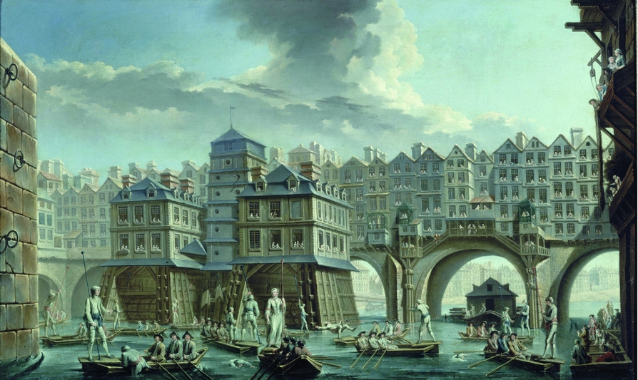
By comparison with the academicians, there were far more Guild artists living on the city's islands and along the quays, although in some respects it is surprising not to find more. The Île-de-la-Cité in particular was a crucial centre for this community, the site of the Guild itself on Rue du Haut Moulin, where the Académie de Saint-Luc had its teaching rooms.Footnote 33 And there was also Pont-Notre-Dame, a key commercial zone for the lower end of the art market, with its numerous picture-dealers and marchands-merciers, including, most famously, the shop of Edmé-François Gersaint.Footnote 34 The island may have been home to a more significant concentration of Guild artists at other stages in its history, but clearly by the 1770s the institution's premises were not playing the same determining role in address choice as the Louvre was for the Academy's members, not least because the Guild had no provision for residential space. Artistically speaking, however, one local Guild artist who engaged deeply with this area was Nicolas-Jean-Baptiste Raguenet, who lived on the island's Rue de la Licorne in the 1750s.Footnote 35 If Demachy was the pictorial chronicler of the Louvre quartier, then Raguenet did the same for the Seine. In works like Mariners Jousting between Pont-Notre-Dame and Pont-au-Change (Figure 7), Raguenet made detailed depictions of the spaces and structures around the river (here the buildings lining Pont-Notre-Dame) and captured a sense of life in these neighbourhoods, whether in local events like this sporting contest, or in more quotidian activities.Footnote 36
Nicolas-Jean-Baptiste Raguenet, Mariners Jousting between Pont-Notre-Dame and Pont-au-Change, 1756. Oil on canvas, 60 x 97 cm. Musée Carnavalet, Paris. Photo credit: Roger-Viollet/Topfoto.

While it is the differences between the two 1776 maps that are most evident – between the highly centralized Academy and the widely dispersed Guild – it is the intersections between these two communities that are more intriguing. For instance, the fact that nearly 10 Guild artists were living in the Academy's territory of the Louvre, mostly in streets surrounding the palace, but even, in the case of one Monsieur Alizer, in the palace itself. Or conversely, the fact that all those academicians who lived on Rue Meslay or near the northern city gates were evidently living in neighbourhoods dominated socially by the Guild. In fact, right across the city, despite the concentration of the Academy's artists by 1776, there were still many instances of inter-institutional neighbours: Hubert Robert (Academy) and Monsieur Nicolet (Guild), both living in the Arsenal; Jean-Charles Le Vasseur (Academy) and Augustin de Saint-Aubin (Guild), both on Rue des Mathurins; and Guillaume Voiriot (Academy), Adélaïde Labille-Guiard (Guild) and François-André Vincent (Guild), all on Rue Neuve des Petits-Champs. Given the institutional rivalry, there is a tendency to envisage the Guild and the Academy as separate social spheres, but in everyday experience the two communities were far more entwined. The demographic synergies in these maps suggest the diversity within both institutions, as well as the geographic ties that drew them together. Academicians and Guild artists lived on the same streets, moved through the same spaces, and encountered each other in all manner of neighbourhood interactions. Indeed, far from distinct, the two institutions often overlapped quite directly. Even just among those Guild artists already mentioned, Saint-Aubin had been agréé (provisionally accepted) by the Academy in 1771, and Vincent and Labille-Guiard would become academicians in 1782 and 1783 respectively.Footnote 37 Moreover, later in their lives, Labille-Guiard and Vincent would marry, in 1800, after a life-long association which, as Elizabeth Mansfield has discussed, began on Rue Neuve des Petits-Champs.Footnote 38
Alternative geographies: Parisian artists beyond Paris
So far, Paris's art world has been encountered in city maps as a local urban community, but throughout the eighteenth century many of the Academy's artists lived for short or extended periods in other cities, at home and abroad. Pulling back to a larger scale, we find the alternative geographies of a Parisian art world far from restricted to its city limits. Right from its foundation, the Academy had been a community with a transnational outlook, with many of its original members having studied in Rome and considering the Italian academies models for emulation. Italy continued to play a key role – with a branch of the French Academy established in Rome in 1666, for young history painters and sculptors to go and complete their training – but it was not the only travel destination.Footnote 39 As the reputation of the Academy grew and France established its artistic supremacy across Europe, Paris's academicians were in high demand, taking roles in foreign courts and tapping into other art markets. At the same time, foreign artists came to join the Academy and work in Paris. For the institution's earlier decades, it is difficult to track its international reach from address data, because the concierge’s register recorded travelling artists as simply ‘absent’, without a precise location. From 1707, however, the register (and later the Almanachs Royaux) included the towns in which absent artists were living, allowing a sense of their progressive spread throughout the eighteenth century.
In the first decades of the 1700s, the majority of the Academy's absent artists were to be found in other French towns, with just a few in foreign cities (e.g. in 1707, six were elsewhere in France and three were overseas). By the 1720s, the growing international prestige of French artists had reversed this trend, with far more of the absent artists living abroad. Of the 16 academicians absent from Paris in 1726, 11 were in European cities (Berlin, Dresden, London, Madrid, Rome and Venice), and 5 were in other French towns (Auxerre, Lunéville, Marseille, Toulouse and Versailles) (Figure 8). Visualizing the Academy's full geographic spread in 1726 thus requires a map of western Europe. Over the subsequent decades, academicians began travelling even further afield, especially from the 1750s. Of the 17 academicians absent from Paris in 1776, 13 were living across Europe (Berlin, Dresden, Madrid, Malta, Parma, Rome, Stockholm, St Petersburg and Turin) and 4 were elsewhere in France (Lyon, Montdidier, Rouen and Versailles) (Figure 9). Unlike the North American connections of the London Royal Academy, the Paris Academy operated a much more continental network.Footnote 40 Nevertheless, though far from a world map, the spread of Parisian artists in 1776 extended well beyond western Europe to reach right across the continent: east into Russia, north into Scandinavia and south into the deep Mediterranean.
Map showing cities in which the Académie Royale's artists were living in 1726 (based on the addresses in the membership lists kept by the Académie, ENSBA MS 21). Base map: © Mapbox, © OpenStreetMap. Map created by the author.

Map showing cities in which the Académie Royale's artists were living in 1776 (based on addresses published in the Almanach Royal of 1776). Base map: © Mapbox, © OpenStreetMap. Map created by the author.

In these two European maps, we encounter a cartographic model that repositions Paris's academic art within transnational and transregional networks of practice. A more granular look at these travelling artists, even just in these sample years, provides context for their activities. Several artists on both maps were foreign artists who worked in Paris before returning to their home countries, like, in 1726, the Venetians, Rosalba Carriera and Sebastiano Ricci, or in 1776, the Swedish Gustaf Lundberg, the Prussian Anna-Dorothea Therbusch, the Spanish Manuel Salvador Carmona and the Italians, Giuseppe Baldrighi, Francesco Ladetti and Carlo-Antonio Porporati. Most, however, were French artists living and working abroad. In 1726, the majority were artists with official positions in foreign courts: Louis de Silvestre and François Coudray at the court of Saxony in Dresden; Antoine Pesne at the Prussian court in Berlin and Jean Ranc, Michel-Ange Houasse, Jean Thierry and René Frémin at the Spanish court in Madrid. In 1776, it was more common to be working in a foreign or regional academy, like Étienne-Maurice Falconet and Nicolas-François Gillet at the Imperial Academy in St Petersburg, or Charles-François Hutin at the Academy in Dresden. In both years, as always, there was an academician in Rome serving as director of the French Academy – Nicolas Vleughels in 1726 and Joseph-Marie Vien in 1776. But in 1776, Rome was also home to Vien's artist wife, Marie-Thérèse Reboul, and to the former director, Charles-Joseph Natoire, who never returned to Paris after his Roman posting. Aside from artists pursuing careers in the French provinces, including those at regional art schools (e.g. Donat Nonotte in Lyon and Jean-Baptiste Descamps in Rouen, both in 1776), there were also a rare few academicians across the century who embarked on independent international careers. One of these, in 1776, was Antoine Favray, who worked as a portraitist and genre painter across Europe, as far as Constantinople, and spent most of his career in Malta as a member of the Order of the Knights of Saint John.
Mapping the Academy's absent travellers, we find the Paris art world not just as a local community, but as a cosmopolitan and internationally interconnected community. From the outset, the Academy had been an institution that imagined itself as part of a European art world, accommodating foreign artists in its ranks and encouraging the activities of its French members abroad. As a result, this Parisian institution always comprised a range of national backgrounds, valued knowledge of foreign art and culture and wielded a far-reaching influence through its extensive membership network. While the city map (Figure 5) showing the Academy's increasing centralization by the 1770s could be misinterpreted as an indicator of inwardness or parochialism, the international map from that same moment (Figure 9) casts it instead as a local institution with an established sense of its global reach.
Conclusion
Through a spatial and city-oriented approach, this article has brought the urban context of the eighteenth-century Paris art world back into focus. In a search for what the city might tell us about its artists, this cartographic inquiry has revealed the distinct spheres of the art world's institutions, while at the same time highlighting their intersections. Tracing the Academy's members over the century showed the cohesion of this community growing alongside its prestigious reputation, becoming increasingly centralized in the city, while simultaneously spreading further afield internationally. Meanwhile, the Guild's members, at the moment of the institution's demise at any rate, though large in number were far from unified as a community, spread throughout the city and showing little inclination to gather near the Guild itself. Despite, or perhaps because of, these disparate institutional narratives, the maps also mark out spatial connections between two supposedly antagonistic art-world communities, suggesting the social diversity within both groups, and the alternative artistic interactions that may have emerged within neighbourhoods. Pulling out from this local history of the city, the cartographic approach also highlights the larger geographic limits of Paris's art world in this period, complicating any sense of an artistic community contained within national or mono-cultural boundaries.
For the other side of this inquiry – what these artistic communities might reveal about the history of the city – these maps have begun sketching out the earlier chapters to that later, more familiar, story of Paris's urban cultural history. Paris is a city whose art world has always been associated with defined neighbourhoods, but within the differently urbanized spaces of the eighteenth-century city, this article highlights an alternative set of quartiers for art-historical exploration, especially the streets and buildings of the 1st, 2nd and 13th arrondissements. Perhaps even more interestingly, however, they also show many parts of the city where the terrains of these cultural histories overlap. In the 6th and 9th arrondissements, for instance, the plotted points of eighteenth-century artists’ studios indicate much longer artistic histories predating the communities that flourished around Montparnasse or Saint-Lazare in the nineteenth and twentieth centuries. And with the urban expansion of Paris towards the end of the eighteenth century, when artists like Pigalle moved out to inhabit those limits, we even find the very beginnings of an artistic presence in that modernist heartland of the northern boulevards at the base of Butte Montmartre.
Though but a step towards that familiarity we have with the city's place in modernist art history, this article and the digital mapping project from which much of its analysis was drawn are intended to encourage deeper investigations into the local spaces of the eighteenth-century art world. Following the enticing paths revealed in these maps, it is possible not only to trace out the neighbourhoods where art was made, but also to explore their role in facilitating artistic collaborations and personal relationships (like the marriage of Labille-Guiard and Vincent, or all those neighbours on Rue Meslay), inspiring artistic engagement with urban spaces (like those paintings by Demachy and Raguenet), developing art markets (like the commercial spaces of Rue Saint-Jacques, Rue Saint-Honoré or Pont-Notre-Dame), reinforcing relations with patrons (like the nobles and connoisseurs walking the Louvre's corridors) and generating new movements within the wider art world. The maps do not do this work on their own, but they provide an empirical foundation upon which to build more detailed perceptions of community, interaction, exchange and movement, both economic and social. In bringing the urban environment to the foreground, this cartographic approach to eighteenth-century French art begins the work of understanding the city not only as a setting for, but as an agent in, the production of art and the lives of artists.