


INTRODUCTION
Water resources in the Mediterranean region are facing huge challenges due to climatic and anthropogenic changes (Milano et al. Reference Milano, Ruelland, Fernandez, Dezetter, Fabre and Servat2012). Agriculture is likely to encounter the most serious threats due to water scarcity, as it is the major consumer of water. At the same time, demographic shifts, economic development and lifestyle changes are expected to intensify the competition between agricultural and other uses of water, such as municipal and industrial (Mesa-Jurado et al. Reference Mesa-Jurado, Martin-Ortega, Ruto and Berbel2012). Long-term imbalances in supply and demand for irrigation water in most Mediterranean countries are expected to be further intensified, as limited and unequally distributed rainfall is following a declining trend, whereas mean temperature follows an increasing one (Iglesias et al. Reference Iglesias, Mougou, Moneo and Quiroga2011b ). Therefore, crop evapotranspiration (ET) and net irrigation requirements (NIR) are expected to increase due to the changing climate (Rodriguez-Diaz et al. Reference Rodriguez-Diaz, Weatherhead, Knox and Camacho2007; Lovelli et al. Reference Lovelli, Perniola, Di Tommaso, Ventrella, Moriondo and Amato2010; Tanasijevic et al. Reference Tanasijevic, Todorovic, Pereira, Pizzigalli and Lionello2014; Valverde et al. Reference Valverde, Serralheiro, De Carvalho, Maia, Oliveira and Ramos2015). As a result, increased agricultural water demand needs to be met in a context of diminishing availability, through an adaptation approach where water management is inter-related to food security goals, rural development and natural resource management (Iglesias & Garrote Reference Iglesias and Garrote2015).
The estimation of crop water demands (ET) and NIR are pre-requisites for the implementation of adaptation strategies and agricultural water management in general. The magnitude of these parameters, in association with the total surface of cultivated crops, may contribute to the determination of the volume of irrigation water needed in a specific area. Precipitation, along with various parameters of the hydrological cycle, such as runoff and ET, determine the volume of surface and groundwater availability for irrigation (Mizyed Reference Mizyed2009; Supit et al. Reference Supit, Van Diepen, De Wit, Wolf, Kabat, Baruth and Ludwig2012; Gohari et al. Reference Gohari, Eslamian, Abedi-Koupaei, Massah Bavani, Wang and Madani2013), ultimately affecting crops’ potential production and food security (Döll Reference Döll2002; Mizyed Reference Mizyed2009; Matthews et al. Reference Matthews, Rivington, Muhammed, Newton and Hallett2013). Moreover, precipitation and temperature, which greatly influence ET and NIR, are highly characterized by inter-annual but also spatial variability. As a result, the overall trend of either an increase or decrease of ET or NIR value in a region does not necessarily reflect a similar trend for this parameter in all areas within the region (Ribalaygua et al. Reference Ribalaygua, Pino, Pórtoles, Roldán, Gaitán, Chinarro and Torres2013; Cabré et al. Reference Cabré, Solman and Núñez2014). Hence, it is of paramount importance to examine temporal and spatial variability of ET and NIR carefully, as they are expected to determine the water resource management schemes to be undertaken and restructuring of crop distribution eventually needed as a means to adapt to the increased water demand of the future (Olesen & Bindi Reference Olesen and Bindi2002; Iglesias et al. Reference Iglesias, Garrote, Diz, Schlickenrieder and Martin-Carrasco2011a ; Schilling et al. Reference Schilling, Freier, Hertig and Scheffran2012).
Cyprus, an island country located in the eastern Mediterranean Sea, is experiencing long-term high water demand, with the agricultural sector of the country being most affected. It is worth noting that average annual rainfall in Cyprus reveals a decreasing trend in the last 40 years (Pashiardis & Michaelides Reference Pashiardis and Michaelides2008), whereas annual mean temperatures show an increasing trend (Price et al. Reference Price, Michaelides, Pashiardis and Alpert1999; Giannakopoulos et al. Reference Giannakopoulos, Hadjinicolaou, Kostopoulou, Varotsos and Zerefos2010). Thus, there is a growing concern that both the ET and NIR values in Cyprus have been increased (Metochis & Orphanos Reference Metochis and Orphanos1988; Metochis Reference Metochis1989, Reference Metochis1997). Such an increase is important, as the agricultural sector in Cyprus consumes nearly 0·70 of the total water resources available on the island. Huge infrastructures, such dams and water reallocation projects, have been constructed to supply adequate irrigation water to agricultural areas. Moreover, several agronomic and policy measures have been adopted towards the alleviation of the irrigation water demand, with the most important being the reuse of wastewater for irrigation, the extended use of advanced irrigation systems and the adoption of the recycling nutrient solution in greenhouses (Christou et al. Reference Christou, Eliadou, Michael, Hapeshi and Fatta-Kassinos2014; Neocleous & Savvas Reference Neocleous and Savvas2015).
The aim of the current study was to estimate and compare temporal trends and spatial variability of ET and NIR values of the two crops that consume most water in Cyprus (i.e. citrus and potatoes) due to their cultivated area (0·42 of the total island cultivated area) (Markou & Papadavid Reference Markou and Papadavid2007). An additional aim was to estimate the ET and NIR values of a large number of permanent and annual crops for two successive 24-year periods (1976–2000 and 1990–2014) and discuss the implications of their eventual modifications on agricultural water management.
MATERIALS AND METHODS
Description of the study area and crop distribution
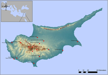
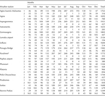
Cyprus is a semi-arid island located in the eastern Mediterranean Sea (35°N, 33°W) with a total land area of 9254 km2. The altitude ranges from 0 to 1951 m above sea level (a.s.l.), while the island can be separated into four distinct geographic areas: the Troodos mountain (1951 m a.s.l.), the Pentadactilos mountain (1024 m a.s.l.), the Mesaoria plain between the two mountains, and the coastal plains and valleys (Fig. 1). Consequently, the climate has spatial and temporal variations because of the varying topographic characteristics arising from the mountainous terrain. Cyprus has a typical Mediterranean climate characterized by hot, dry summers and mild, wet winters. The annual temperature in the country range from 14 to 17 °C during the winter period and 30 to 35 °C during the summer. Average annual precipitation is 480 mm, with the highest and lowest values being recorded in the higher altitudes of the Troodos Mountain (1100 mm) and in the eastern coast (300 mm), respectively. Precipitation occurs largely during the winter period; summers are very dry (Table 1).
Spatial distribution of the 16 weather stations providing meteorological data during the period 1976–2014 in a contour map of the Republic of Cyprus. Colour online.

Long-term (1976–2014) mean monthly USWB Class A pan evaporation (mm) and precipitation (mm) data from the 16 studied weather stations

1: USWB Class A pan evaporation (mm); 2: precipitation (mm).
* Data recorded during the period 1976–2007.
The agricultural sector in the island can be separated into rain-fed cereals, grown during the winter period, and irrigated crops, grown throughout the year. Irrigated agriculture is practiced mainly through advanced pressurized systems, such as drips and sprinklers, and consumes nearly 0·70 of all water resources used per annum (~160 million cubic meters, MCM). Citrus and potatoes are planted on 0·42 of the total irrigated area of the country and consume one-third of the total agricultural water (0·23 and 0·10, respectively, total of 55 MCM) (Markou & Papadavid Reference Markou and Papadavid2007). Agricultural water is provided mainly through government irrigation schemes (~0·55), consisting of dams and irrigation pipeline networks, as well as water withdrawal from aquifers (~0·30) and treated wastewater (~0·15), depending on the water volumes stored in dams. It is worth noting that Cyprus has constructed a large number of dams (108) that can store approximately 332 MCM of water, which are served by a huge network of pipelines and canals, so that the water can be shared among all sectors.
Irrigated agriculture can, therefore, be divided into annual and permanent crops. The permanent crops considered in the current study include citrus, olives and vine orchards, bananas, fruit trees (apple, pears, etc.), almonds, walnuts and pistachios. On the other hand, annual crops comprise beans, peanuts and horticultural crops, such as vegetables (melons, tomatoes, eggplants, cucumbers, peppers, onions, etc.) and leafy vegetables (lettuce, celery, spinach, etc.). The crops chosen to be studied are the most representative for the Cyprus (and Mediterranean region) agricultural sector and greatly contribute to the agricultural economy of the country.
Meteorological data
Data from 16 weather stations provided by the Cyprus Meteorological Services were used in the current study. Mean monthly precipitation (mm) and pan evaporation (Epan, mm) data from screened United States Weather Bureau (USWB) Class A pan evaporimeter for the period 1976–2014 were available within each station (Table 1). The weather stations selected were those that provided continuous data throughout the period studied (with the sole exception of Paralimni station, which provided data from 1976 to 2007), and included coastal as well as inland and mountainous regions (Fig. 1) that were representative of the main agricultural areas in Cyprus. Climatic data from 15 weather stations (those providing continuous data during the period 1976–2014) were used to calculate average ET and NIR values, whereas data from the Paralimni weather station were incorporated only for evaluating the trends of potato ET and NIR, since this area is the most important for potato cultivation.
Estimation of crop evapotranspiration and net irrigation requirements
Crop evapotranspiration (ET; mm) was calculated from reference evapotranspiration (ETo, mm; ETo = K p × Epan, where K p is the pan coefficient which ranged from 0·75 to 0·85 in the weather stations studied) based on pan evaporation data (Epan) obtained from the weather stations using Eqn (1), following the methodology proposed by Allen et al. (Reference Allen, Pereira, Raes and Smith1998),
 $${\rm ET} = Kc \times {\rm ETo}$$
where the values of the crop coefficient (K c ) to be used for a specific crop were derived from the literature (Doorenbos & Pruitt Reference Doorenbos and Pruitt1992; Allen et al. Reference Allen, Pereira, Raes and Smith1998), as well as from data derived from field experiments conducted at the Agricultural Research Institute of Cyprus, over a long period (Metochis Reference Metochis1980, Reference Metochis1989; Metochis & Orphanos Reference Metochis and Orphanos1981, Reference Metochis and Orphanos1988, Reference Metochis and Orphanos1997; Stylianou & Orphanos Reference Stylianou and Orphanos1981; Eliades Reference Eliades1992). The value of K c varies among plant species, as well as among crop growth stages. Indicatively, the K c value for citrus and olive trees at the stage of full development is 0·70. For table grapes (i.e. grapes for consumption rather than wine-making), the K c value rises from 0·30 at the initial stage of leaf appearance to 0·70–0·85 in May and June, while for deciduous trees (no ground cover), it ranges from 0·55 to 0·60 during spring, rising to 0·90–0·95 during the summer and dropping to 0·65–0·75 during the autumn. Moreover, K c values rise from 0·50 during spring to 1·10 in August for bananas (1st year), whereas for alfalfa, it is 0·40 during the period from October to April and rises to reach a value of 1·20 in July. The K c coefficient ranges from low (0·50) to high (1·00) values for seasonal vegetative crops, depending on the growth stage of the plant. For small vegetables, K c values range from 0·70 during the early initial stage to 0·90–1·05 when plants reach the stage of full development, and then decline to values of 0·40–0·60 during the late season stage. Moreover, in order to compute the NIR of crops, the effective rainfall (Pe; rain water stored in the root zone that can be used by the plants, not evaporated, percolated below the root zone or lost by runoff) during the growing period was subtracted from actual water requirements (ET values). More precisely, the total monthly rainfall was converted to Pe using a simplified method proposed by Brouwer & Heibloem (Reference Brouwer and Heibloem1986), based on empirical observations and requiring only the total monthly volume of precipitation. The parameters for this calculation, published in Brouwer & Heibloem (Reference Brouwer and Heibloem1986), can be accessed at http://www.fao.org/docrep/s2022e/s2022e08.htm#4.2 determination of the effective rainfall* (accessed 23 June 2017).
Evaluation of spatial and temporal variability of crop evapotranspiration and net irrigation requirements
Actual water requirements, NIR and Pe of the two highest water-consuming crops (potatoes and citrus) were investigated in their four main agricultural sites in Cyprus throughout the whole study period (1976–2014), with the sole exception of potatoes in the Paralimni area, where meteorological data were available only during the period 1976–2007. The corresponding pairs of values were subjected to regression analysis in order to reveal the relative significance of these variables in the obtained results. In order to assess the spatial and temporal effects, both the ET and NIR values were evaluated for a number of permanent and annual crops under two overlapping periods (1976–2000 and 1990–2014) in each of the 15 weather stations providing continuous meteorological data during the last 38 years. Values obtained for the two studied periods were compared for each crop. The two overlapping periods chosen to be studied are considered long enough (24 years) for evaluating the overall trends and possible changes of the parameters examined. Notably, other period combinations, both overlapping and not overlapping (i.e. 1976–1995, 1996–2014; 1976–2004, 2000–2014; 1976–2000, 2001–2014) were also studied, providing the same results as described below.
Statistical analysis
The mean ET and NIR values obtained from the 15 weather stations for each crop studied were compared between the two study periods (1976–2000 and 1990–2014) using a paired t test (15 double samples for each crop representing the 15 weather stations). A paired t test was also carried out for assessing the differences of mean ET and NIR values at each station separately across crops between the two periods studied (35 double samples representing the crops studied for each station were used) (Graphpad Software, Inc., San Diego, California, USA). A P value ⩽0·05 in all paired t tests was considered as statistically significant. Linear regression analysis (Graphpad Software, Inc.) was carried out to describe the trends, either positive or negative, of ET and NIR values of citrus and potatoes in their four main agricultural sites, as well as of the effective rainfall.
RESULTS
Temporal and spatial variations of crop evapotranspiration and net irrigation requirements of citrus and potatoes in their four main cultivated areas
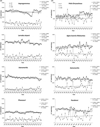
Both ET and NIR values followed a declining trend in all four studied areas cultivated with citrus, while these parameters in the respective areas of potatoes followed both increasing and decreasing trends over the period studied (Fig. 2). Citrus ET and NIR ranged from 6000 in Phassouri to more than 10 000 m3 water/ha/year in Asprogremmos, indicating the spatial variability that characterizes these parameters, while the Pe followed an increasing trend with the sole exception of Asprogremmos (Fig. 2(a)). Potatoes ET and NIR in Polis Chrysochous and Agios Ioannis Malountas displayed lower values compared with the other two cultivated areas. However, an increasing trend in both parameters was recorded both in Polis Chrysochous and Agios Ioannis Malountas compared with the decreasing trend observed in Astromeritis and Paralimni (Fig. 2(b)). It should be noted that the Paralimni weather station recorded meteorological data only during the period 1976–2007; nevertheless, it was incorporated in the current study since it constitutes the most significant area for potato crop cultivation.
Temporal and spatial variations and trends of (a) citrus and (b) spring potatoes evapotranspiration (ET) and net irrigation water requirements (NIR), and the effective rainfall (Pe), in the most significant cultivated areas in Cyprus, represented by the respective weather stations.

Average crop evapotranspiration and net irrigation requirements of crops during two successive periods
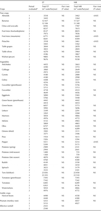
Data analysis was extended to 35 Mediterranean crops cultivated in Cyprus. Average ET and NIR values were calculated based on meteorological data from 15 weather stations, for the periods 1976–2000 and 1990–2014. As shown in Table 2, the average ET of all crops over the studied sites during the period 1990–2014 displayed no statistically significant differences compared with the period 1976–2000. In absolute values, the difference in the ET values of the individual crops surveyed between the two periods ranged from 0 to 209 m3 water/ha/year, with the sole exceptions of taro, as its ET was reduced by 482 m3 water/ha/year in the period 1990–2014 compared with the period 1976–2000. Accordingly, the differences in NIR recorded in the two periods studied were in the range of 21–348 m3 water/ha/year. Notably, the NIR values of all crops in the two periods studied displayed no statistically significant differences, with the sole exception of almonds, fruit trees cultivated in the mountains, pistachio and pepper, whose average NIR value across all weather stations decreased significantly during the latter period (P < 0·05; Table 2).
Seasonal ET and NIR values for all studies crop systems cultivated across the 15 weather stations in Cyprus during the two periods studied (1976–2000, 1990–2014)

NS, non-significant.
* 1: period 1976–2000; 2: period 1990–2014.
Spatial variations of crop evapotranspiration and net irrigation requirements values
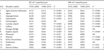
Both ET and NIR were estimated for all crops during the two 24-year overlapping periods studied (1976–2000; 1990–2014) at each of the 15 weather stations. The fact that some crop systems may not be feasible for cultivation in the respective regions of some of the 15 weather stations was purposely ignored. Results revealed that the ET displayed statistically significant differences between the two studied periods across crops within each weather station evaluated, with the sole exception of the Germasogia area, uncovering the significant spatial variation of ET within the country (Table 3). Moreover, six agricultural areas displayed significantly increased ET values during the latest period studied as compared with the previous one, whereas eight agricultural areas followed the opposite trend (decreased ET). The same pattern was recorded for NIR, since this parameter showed no significant differences among the two periods studied in only three weather stations (Panagia Bridge, Phassouri and Prodromos; Table 3). Notably, six agricultural areas displayed increased NIR values during the period 1990–2014 as compared with the period 1976–2000, whereas the same number of sites displayed decreased NIR values.
Differences of crop ET and NIR values between the two periods evaluated (1976–2000 and 1990–2014) in the studied weather stations as revealed by the pair t test

Results were obtained by comparing the mean ET and NIR of all studied crops using the pair t test.
NS, non-significant; ↑increase; ↓decrease.
DISCUSSION
Despite the general decreasing trend of mean precipitation in Cyprus (Pashiardis & Michaelides Reference Pashiardis and Michaelides2008), the current results revealed a discrepancy between overall trends at the country level and site-specific estimates and did not justify any increase in the irrigation demands of at least citrus and potatoes, the two crops that consume the most water. In some places, effective rainfall decreased during the last 40 years and ET increased, but in others there was a tendency towards increase in precipitation accompanied by a respective decrease in ET, or decreases in both precipitation and ET. It should be noted that in some cases the slope of the fitted straight lines was not significantly different from 0. The decreasing trend in both the ET and NIR values, as well as the increasing trend of Pe in the Paralimni area, which constitutes one of the main areas of potato cultivation, is of particular significance for water management, as a huge water transporting infrastructure (Southern Conveyor Project; 110 km long) was constructed to deliver agricultural water to that area, while simultaneously delivering agricultural and potable water to other areas.
Such results support previous results highlighting the spatial and temporal variation of evaporation, precipitation and ETo within the country (Ribalaygua et al. Reference Ribalaygua, Pino, Pórtoles, Roldán, Gaitán, Chinarro and Torres2013; Cabré et al. Reference Cabré, Solman and Núñez2014; Nam et al. Reference Nam, Hong and Choi2015). Moreover, the current results point out the sensitivity of evapotraspiration to climatic change in different regions, due to variations in wind speed, air temperature, humidity and radiation (Tabari & Hosseinzadeh Talaee Reference Tabari and Hosseinzadeh Talaee2014).
Nevertheless, regardless of the local trends in ET and NIR in a specific smaller area within a region, the volume of water stored in dams, and therefore the availability of irrigation water, could be reasonably assumed to be negatively affected by climate change-driven decreased precipitation (Zoumides et al. Reference Zoumides, Bruggeman, Hadjikakou and Zachariadis2014). Such a possibility is of great importance in Cyprus, as it could seriously affect long-term agricultural sustainability.
The statistical analyses applied to data for the majority of crops cultivated in Cyprus by splitting years 1976–2014 into two overlapping periods (1976–2000 and 1990–2014) supported previously described trends for citrus and potatoes. For each crop, the ET and NIR estimates obtained using meteorological data across weather stations were not significantly different between the two 24-year periods. Taking into account the predictions for increased temperature and decreased precipitation in the region (Xoplaki et al. Reference Xoplaki, González-Rouco, Luterbacher and Wanner2004; Mizyed Reference Mizyed2009; Milano et al. Reference Milano, Ruelland, Fernandez, Dezetter, Fabre and Servat2012) and in Cyprus in particular (Price et al. Reference Price, Michaelides, Pashiardis and Alpert1999; Pashiardis & Michaelides Reference Pashiardis and Michaelides2008; Giannakopoulos et al. Reference Giannakopoulos, Hadjinicolaou, Kostopoulou, Varotsos and Zerefos2010), as well as the increased evaporation and ET predicted by a number of regional climate models (Giorgi & Lionello Reference Giorgi and Lionello2008; Lovelli et al. Reference Lovelli, Perniola, Di Tommaso, Ventrella, Moriondo and Amato2010; Tanasijevic et al. Reference Tanasijevic, Todorovic, Pereira, Pizzigalli and Lionello2014), the present results could significantly assist decisions on future water management measures. Moreover, it should be taken into account that predicted increases in ET were mostly obtained using simulation models (Rodriguez-Diaz et al. Reference Rodriguez-Diaz, Weatherhead, Knox and Camacho2007; Lovelli et al. Reference Lovelli, Perniola, Di Tommaso, Ventrella, Moriondo and Amato2010; Tanasijevic et al. Reference Tanasijevic, Todorovic, Pereira, Pizzigalli and Lionello2014; Valverde et al. Reference Valverde, Serralheiro, De Carvalho, Maia, Oliveira and Ramos2015), whereas measurements from several hundred Epan stations worldwide revealed an overall decrease in Epan (Peterson et al. Reference Peterson, Golubev and Groisman1995; Thomas Reference Thomas2000). No changes in ETo were also found during the period 1964–1998 at Bet Dagan in Israel's central coastal plain (close to Cyprus), despite the significant increase recorded in Epan during this period, probably due to the fact that the increases in water vapour pressure deficit and wind speed were offset by decreases in global irradiance (Cohen et al. Reference Cohen, Ianetz and Stanhill2002).
Importantly, the lack of statistically significant change between the two periods studied was evident for crops grown either in late autumn/winter/early spring (such as artichokes, carrots, lettuce, cabbage, spinach and celery), which are favoured by the precipitation occurring during their growing period (NIR < ET) or grown in spring/summer, which mostly rely on irrigation water.
This is probably the first study providing variations of both ET and NIR values for nearly all the typical Mediterranean crops. Previous studies were mainly focused on individual crops or on only a very small number (usually two) of them and rarely reported on changes in irrigation needs through time. Present estimates regarding the ET and NIR values of olive trees (for table olive production) (Table 2) are in accordance with previous studies regarding South Spain (Palomo et al. Reference Palomo, Moreno, Fernández, DíAz-Espejo and Girón2002; Tanasijevic et al. Reference Tanasijevic, Todorovic, Pereira, Pizzigalli and Lionello2014), where a typical Mediterranean climate, like that in Cyprus, prevails. Similar NIR values were also reported for grapevine and horticultural crops in South Portugal for the period 1960–1990 (Valverde et al. Reference Valverde, Serralheiro, De Carvalho, Maia, Oliveira and Ramos2015), while comparable tomato crop ET values were calculated for the Eastern Mediterranean region (Lovelli et al. Reference Lovelli, Perniola, Di Tommaso, Ventrella, Moriondo and Amato2010; Saadi et al. Reference Saadi, Todorovic, Tanasijevic, Pereira, Pizzigalli and Lionello2015). For efficient management of agricultural water, the re-estimation of irrigation water demands based on recent meteorological data, particularly of high water-consuming crops, such as citrus, avocado, bananas, walnut and taro, should be considered a pre-requisite before any cultivation restructuring project is to be applied at a countrywide level (Waha et al. Reference Waha, Müller, Bondeau, Dietrich, Kurukulasuriya, Heinke and Lotze-Campen2013; Ye et al. Reference Ye, Yang, Dai, Chen, Li and Zhang2015).
Within each meteorological station, NIR and ET values showed statistically significant differences (i.e. increases and decreases between the two time periods). From a different standpoint, it was shown once more that general meteorological trends for a country or a large patchy area should be used with caution by water management authorities for estimating the irrigation water demands of crops in a specific location (Ribalaygua et al. Reference Ribalaygua, Pino, Pórtoles, Roldán, Gaitán, Chinarro and Torres2013; Cabré et al. Reference Cabré, Solman and Núñez2014). Crop ET and NIR values vary greatly in both space and time, as the main meteorological parameters determining their magnitude (i.e. air temperature and precipitation) are highly characterized by both inter-annual and spatial variability (Rodriguez-Diaz et al. Reference Rodriguez-Diaz, Weatherhead, Knox and Camacho2007). Jung et al. (Reference Jung, Reichstein, Ciais, Seneviratne, Sheffield, Goulden, Bonan, Cescatti, Chen, De Jeu, Dolman, Eugster, Gerten, Gianelle, Gobron, Heinke, Kimball, Law, Montagnani, Mu, Mueller, Oleson, Papale, Richardson, Roupsard, Running, Tomelleri, Viovy, Weber, Williams, Wood, Zaehle and Zhang2010) reviewed the observed global reference ET (ETo) during the period 1982–2008 using a global network and concluded that the relative importance of meteorological parameters to ETo trends vary spatially and temporally. Moreover, the use of meteorological data from a number of weather stations in a larger area or a whole country in various studies highlighted the remarkable regional and temporal variations of ETo and ET (Liang et al. Reference Liang, Li and Liu2010; Zhang et al. Reference Zhang, Kang, Zhang and Liu2010; Tang et al. Reference Tang, Tong, Kang and Zhang2011; Nam et al. Reference Nam, Hong and Choi2015). Such spatial and temporal variability of meteorological parameters and ET has high significance in Mediterranean regions, since varying topographic characteristics arise in a small total land area from the complicated mountainous terrain. The decreased trend of NIR values in some of the agricultural areas studied is a significant outcome, as it implies that no additional irrigation water is required in these areas in order to satisfy their future irrigation needs, unless the cultivated area is increased. In addition, data provided are of particular relevance in decision support systems used to satisfy crop water requirements, which should primarily take into account the values and trends of both ET and NIR in individual agricultural sites where either an increase or even a decrease to the overall agricultural water needs may prevail.
CONCLUSIONS
Results suggest that the recorded increasing trends in mean air temperature, as well as decreasing trend in mean annual precipitation, and the projections for increased ET and NIR values in the Mediterranean region, are not necessarily reflected in smaller areas within this region and should be assessed carefully. Spatial and temporal variations in meteorological parameters and ET, resulting from the microclimate of particular locations, necessitate a study for each of these locations separately. Agricultural water resource management and related implemented schemes aiming to deal with diminishing irrigation water availability should be applied at the local level (specific areas) rather than at a region or country level, with emphasis being given to the values and trends of ET and NIR of crops mostly cultivated in these areas. Restructuring agricultural land in a way that specific crops are cultivated in areas where their ET values are lower compared with other areas or where their ET and NIR values follow a decreasing trend, may serve for the conservation of agricultural water in the future, or even provide the possibility for the expansion of their cultivated area in a region.
This study was supported by Cyprus Agricultural Research Institute Internal Grant to Anastasis Christou (ARI 1303207/5·6).