Introduction
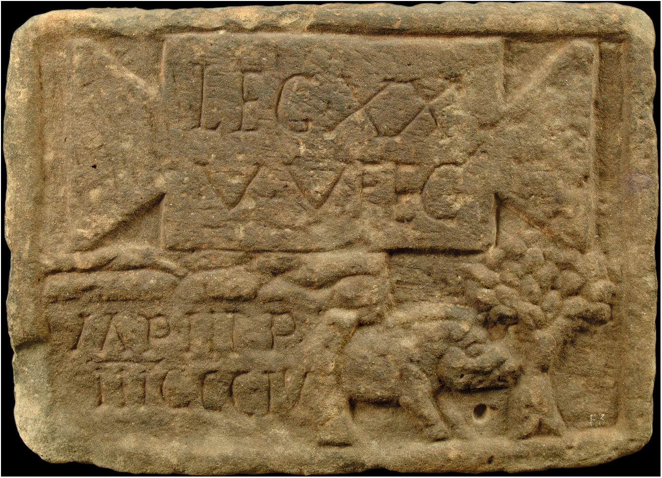
The surviving collection of 18 monumental inscriptionsFootnote 1 that record the division of work between the three legions responsible for the building of the Antonine Wall, traditionally known as distance slabs,Footnote 2 are rightly famous. They are without parallel on any other Roman linear frontier. Not only are the great majority of them complete, or very nearly so, but they provide unusually specific and quite detailed information about the monument to which they relate. Moreover, several of them, notably the examples from Bridgeness, Summerston, Hutcheson Hill, Braidfield (Fig. 4a, below) and Old Kilpatrick (Ferrydyke), feature quite elaborate sculptural decoration.Footnote 3 Accordingly, they have been much studied over more than three centuries from both an epigraphic and an iconographic perspective. The intention here is not merely to summarise aspects of our understanding of this collection, but to review critically assessments of the character and function of these unique stones, offering some new insights in the process.
The uniqueness of the distance slabs
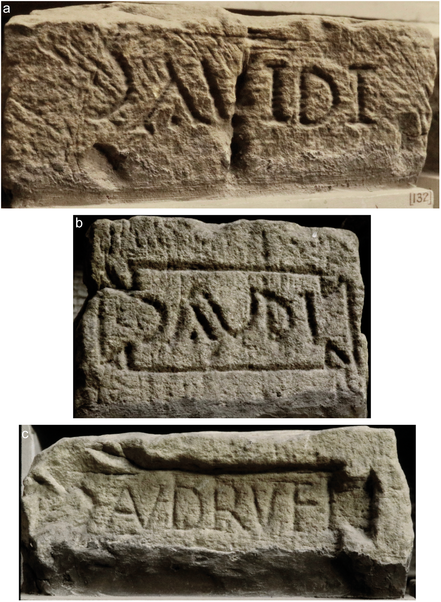
Inscriptions that celebrate the completion of a building project are commonplace in military contexts around the Empire. Their primary function seems to have been to allow the military unit that undertook the work to record its responsibility. Perhaps the largest well-preserved collection of such stones, over 200 in number, come from the curtain of Hadrian’s Wall. They are collectively referred to as ‘centurial stones’ as they serve to identify the century, less frequently the cohort, that built a particular section of the curtain.Footnote 4 Though similarly consistently well preserved, this group from an equivalent structure provides a marked contrast to the Antonine Wall distance slabs in several ways: they are far more numerous, predominantly much smaller and largely undecorated, providing for the most part only a minimal textual record (Fig. 1). Inscribed stones of similar character to the centurial stones are still visible built into a different form of linear structure at the opposite end of the Empire. Some ten record the reconstruction under Hadrian of the aqueduct at Caesarea Maritima in Israel by detachments of the three or four legions involved.Footnote 5 Though most are in simple tabula ansata form, none are otherwise decorated, nor do they provide either direct reference to the structure or record the distance built.
Three centurial stones from Hadrian’s Wall west of Carrawburgh. Their simplicity of form and minimal variation highlight the utilitarian nature of these building stones. All are fairly crudely inscribed and mark work by the century of Avidius Rufus: (a) and (b) inscribed  AVIDI (RIB I, 1564 and 1565); (c) inscribed
 AVID RUFI (RIB I, 1567). Photos R.S.O. Tomlin.

Larger and more elaborately sculptured building inscriptions are known from Hadrian’s Wall and its outpost forts, but these come usually from buildings within forts. Like the distance slabs, these may involve a dedication to the reigning emperor and an indication of the governor or unit commander under whose auspices the work was undertaken.Footnote 6 Only infrequently, however, do any of them indicate what had been built,Footnote 7 primarily because this would have been self-evident from the location of the inscription attached to the structure concerned. Indeed, a number of the centurial stones from Hadrian’s Wall were found in situ.Footnote 8
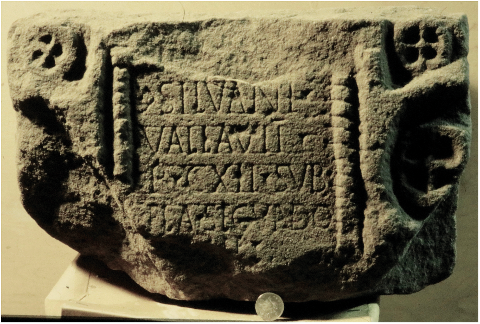
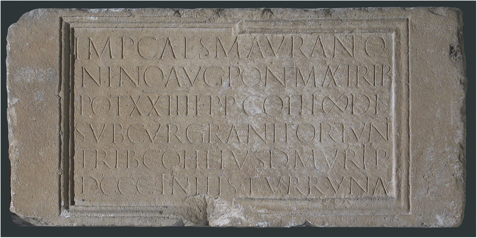
Parallels for a precise specification of the length of stone wall or turf rampart that had been constructed are considerably fewer in number. Examples include five of the centurial stones from Hadrian’s Wall, which record in minimal terms the building of either 22 or 30 Roman feet using the abbreviation P for p(edes) in all but one case.Footnote 9 Similarly, six building inscriptions on small, thin stone plaques from Carvoran record the construction of the fort wall by different centuries of cohors I Hamiorum under the command of their prefect Flavius Secundus: three specify quite short lengths from 19 to 30.5 feet; three indicate lengths in excess of 100 feet (Fig. 2).Footnote 10 Finally, perhaps the closest parallels to the distance slabs can be found in Dalmatia, where four building inscriptions, two still in situ, record the rebuilding of specific lengths of the city walls of Salona in a.d. 170 by two legionary vexillations each responsible for 200 feet (ped(es) CC) and two auxiliary units each responsible for 800 feet (ped(es) DCCC) (Fig. 3).Footnote 11 While these are well-preserved monumental inscriptions providing detailed information about the construction involved, they almost entirely lack decoration.
Building stone from Carvoran recording the construction of 112 feet of rampart by the century of Silvanus (RIB I, 1820). Photo R.S.O. Tomlin.

Distance slab recording the construction of 800 feet of the city wall and a tower at Salona by cohors I milliaria Delmatarum (CIL III, 1979) (© The Archaeological Museum, Split).

Thus, while all of the individual features of the distance slabs — identification of the unit responsible; dedication to the emperor; detailed specification of the distance constructed, monumental size, elaborate decoration, excellent survival — can be paralleled in Britain and, indeed, elsewhere in the Empire, it is the combination of these features that makes the distance slabs stand out and justifies the frequent reference to them as a unique set of building records.Footnote 12
Finally, it is worth stressing the considerable variability of the individual distance slabs. Given their similarity of purpose, Keppie expresses some surprise at their variety of shapes, sizes and styles. Indeed, no two are the exactly the same. At the same time, however, he does note some matching examples recording the work of the same legion.Footnote 13 Thus, the slabs of the Second Legion from Duntocher and Carleith are clearly very similar in size, decoration and layout, as are the slabs of the Sixth Legion from Eastermains, East Millichen and Castlehill, and those of the Twentieth from Hutcheson Hill and Old Kilpatrick (Dalnotter).Footnote 14 Other more subtle similarities are also apparent. Thus, the character of the lettering in all six slabs of Twentieth Legion from the Castlehill to the Clyde sector is sufficiently distinctive to suggest that the same hand was at work in cutting, or at least in drawing, the letters. The craftsman uses a distinctive form of the letter A with an angled chevron-like crossbar and a not dissimilar irregular crossbar on the letter H.Footnote 15 This is typical of Greek epigraphy, but is rare in the Latin West. A similar conclusion is also reached by Keppie on the basis of the consistent sculptural style.Footnote 16 This distinctive lettering is absent from the slabs of the same legion attributed to the sections east of Castlehill, adding further weight to the assumption that they belonged to a different season or work-phase.Footnote 17 Similarly, there is a marked consistency in the form of the imperial dedication on a number of the slabs prepared by different legions,Footnote 18 as if the same text had been issued to be inscribed on panels made by different masons (see also Advance preparation, below).
Positioning
It has long been accepted that the distance slabs refer to the construction of the linear barrier, though with some uncertainty about whether all the elements involved were constructed at the same time.Footnote 19 Accordingly, Campbell’s recent suggestionFootnote 20 that the slabs may actually refer to and, accordingly, have been positioned on the Military Way requires a reconsideration of the evidence.
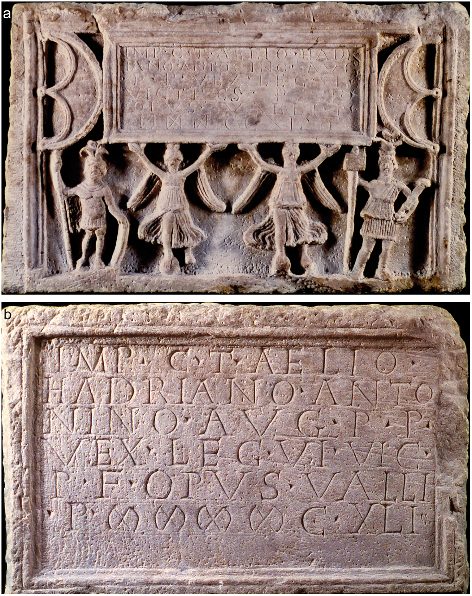
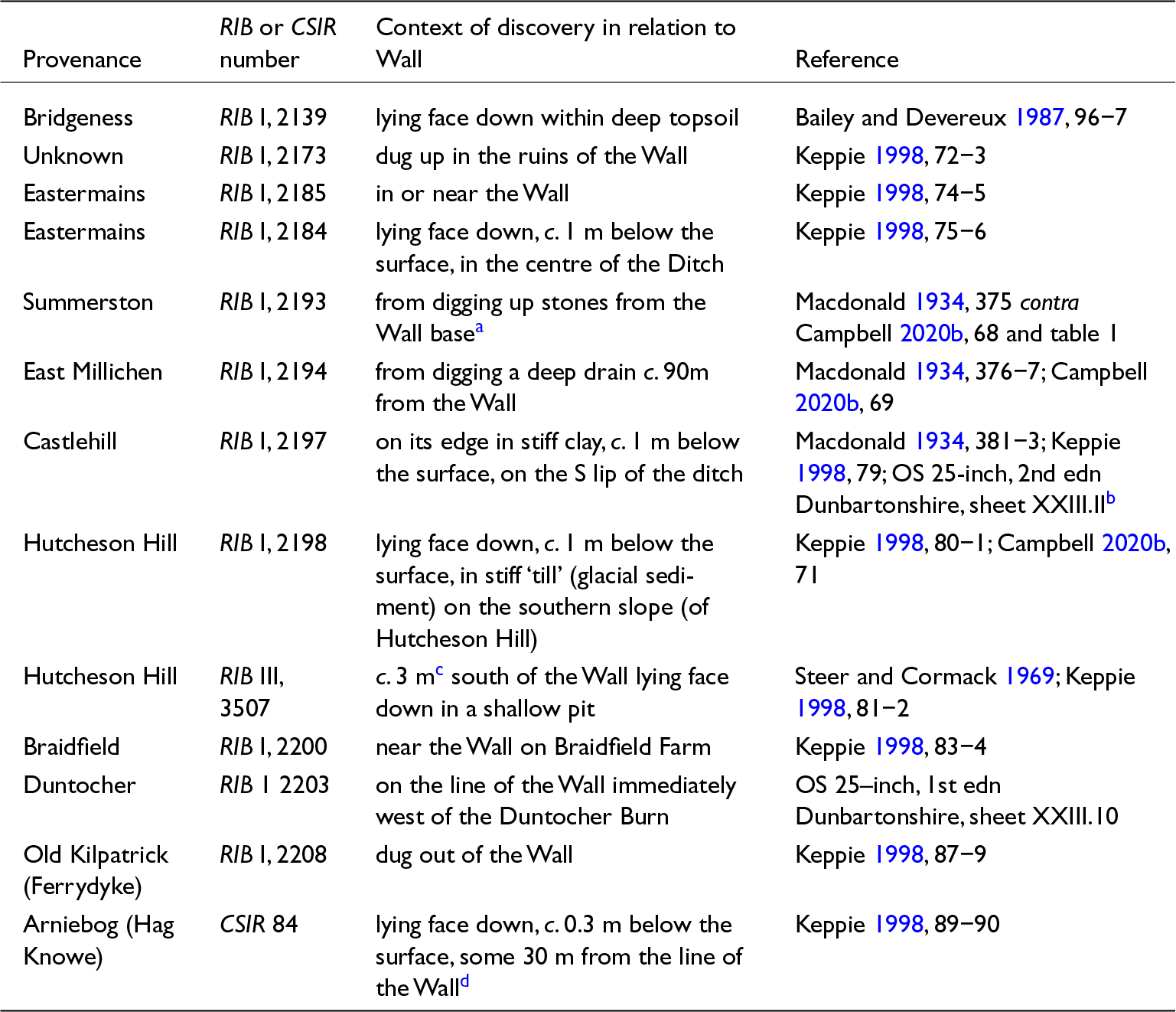
Firstly, the discovery locations of the distance slabs, where this is adequately recorded, are consistently very close to the line of the Wall (Table 2), and in one of the two examples where this does not appear to be the case, at Arniebog, the slab seems to have been broken for re-use (see also Disposal, below). More fundamentally, two of the slabs explicitly state that they relate to work on the rampart (opus valli) (Fig. 4).Footnote 21 Campbell’s attempt to dismiss these as ‘statistical outliers’ because they represent less than 10% of the total collection seems an inappropriate application of statistics given the small numbers involved.Footnote 22 As already noted (see Uniqueness, above), it was not the norm to identify on the relevant inscription the structure that had been built as its location would have made that self-evident. Of the 12 other monumental building inscriptions recovered from the Antonine Wall, seven or eight of which are sufficiently well preserved to be confident of the full reading of the text, only one, from the principia at Rough Castle, actually mentions the structure involved.Footnote 23 The fact that only two of the 18 distance slabs specify the structure represents a broadly equivalent statistical order of magnitude.
Distance slabs from (a) Braidfield (RIB I, 2200) and (b) Old Kilpatrick (probably Dalnotter) (RIB I, 2205) recording the construction of 3,240 and 4,141 feet respectively of the opus valli by the Sixth Legion (© The Hunterian, University of Glasgow).

Hannon et al. emphasise the importance of potential footfall in relation to location of the distance slabs (see also Audience and message, below), suggesting that they may have been positioned at fort or fortlet gateways,Footnote 24 though their own analysis of the LiDAR data indicates that the construction sectors do not readily correlate with known military installations. In support of their suggestion, they point to the well-established need for some masonry backing for the slabs (see below), apparently forgetting that the ramparts of the fortlets and forts were not themselves usually built of stone.
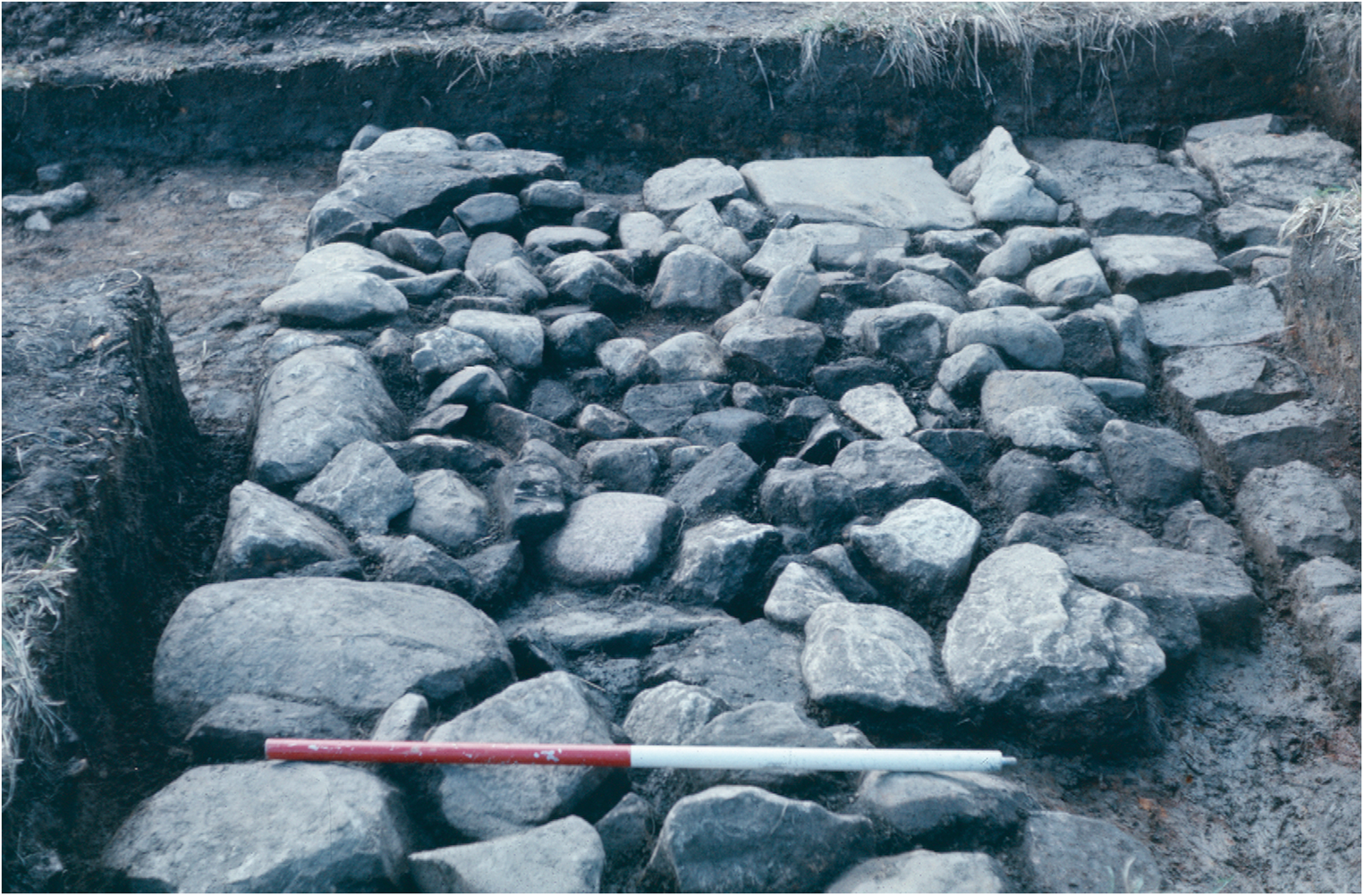
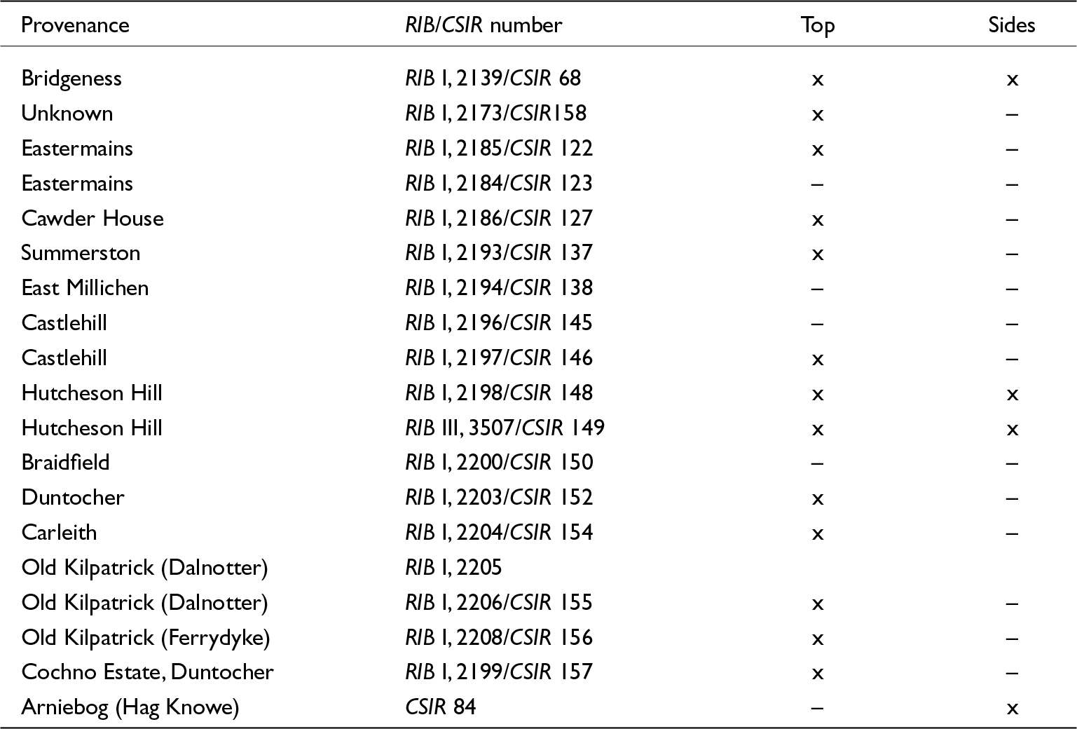
Most of the distance slabs were provided with cramp holes,Footnote 25 usually at the top but sometimes also at the sides (Table 1), which are most clearly evidenced on the Bridgeness slab, the largest of the stones. One of the examples without cramp holes (one of the two from Eastermains) is also the smallest of the stones and takes the form of a substantial tapering block.Footnote 26 Both the cramp holes and the taper on the stone from Eastermains must indicate that the slabs had been designed for insertion into some form of masonry structure, as various writers have long recognised.Footnote 27 It would be entirely in accordance with Roman custom to envisage such a structure being set up against the front and/or rear face of the rampart.Footnote 28 Moreover, an example of a possible support structure has been recorded on the eastern flank of the hill known as Hag Knowe, close to the find-spot of the distance slab from Arniebog. Consisting of a well-defined cobble base some 1.8 m wide and 11.4 m long,Footnote 29 it had been added to the rear of the rampart (Fig. 5) and was considered to be too massive and too regular simply to be a repair, particularly when compared to an example of the latter found nearby a few years earlier.Footnote 30 It was not identified as the base for the Arniebog distance slab because the excavators considered it to be too long and were uncertain about what, if anything, might have been built above it.Footnote 31 However, its superstructure was likely to have been stone, as there was no sign of turf in the interstices between the cobbles, Footnote 32 in contrast to the adjacent base of the Wall rampart, and the length seems less problematic when considering that it is likely to have supported adjacent monumental inscriptions marking the division between the work of two legions.
The western end of the narrow, kerbed platform added to the rear of the Wall at Tollpark/Hag Knowe. The rear kerb stones of the Antonine Wall rampart base are visible to the right; those at the top of the image define the western end of the platform (© Prof. Lawrence Keppie).

Provision of cramp holes on distance slabs.

It is more difficult to envisage a series of independent structures being erected beside the Military Way to serve as supports for the slabs. Indeed, the normal procedure for recording the construction or repair of roads was to erect milestones, which are designed to be freestanding. Milestones are attested along both the Military Way immediately behind Hadrian’s Wall and on the Stanegate slightly further to the rear, though only one example from the Antonine Wall, now lost, has so far been recorded from the line of the Military Way, at Bar Hill.Footnote 33 All the dated examples from Hadrian’s Wall are from the third and fourth centuries a.d., including five found at Crindledykes on the line of the Stanegate that record five different emperors. This dating pattern seems to reflect the political instability in the later empire with its frequent changes of emperor rather than any pressing need for regular road repairs.Footnote 34
Audience and message
Breeze and Ferris are clearly correct in identifying the primary audience as the Roman soldiers themselves,Footnote 35 not least because locally only they, and perhaps their families, would have been able to read and understand the Latin text. The main messages of that text were the glorification of the emperor and the celebration of the soldiers’ own achievements in the construction of the frontier. It was standard practice on such dedicatory building inscriptions to begin with the names and titles of the emperor, but in the case of the distance slabs this aspect is notably dominant, with at least half of the text on most of the slabs taken up with the titles and full name of Antoninus Pius (e.g. Fig. 4a and b). As already noted (see Uniqueness, above), the consistency in the form of this imperial dedication suggests that a textual crib may have been circulated to the masons involved. However, the two smallest slabs, from Eastermains (Fig. 6) and Duntocher, omit any reference to the emperor, though on a third from Carleith, whose size and layout otherwise mirrors the Duntocher slab, his name and titles are squeezed in around the upper decoration as if they were an afterthought.Footnote 36 Similarly, the inscription seems to be secondary to the decoration in two of the larger and more elaborately sculpted slabs, from Old Kilpatrick (Ferrydyke) and Hutcheson Hill,Footnote 37 though rather better integrated in one case than the other. What is striking is that none of the slabs mention the imperial legate, the governor of Britain, as if seeking to ensure that all glory for the achievement was focused on the emperor, even though Lollius Urbicus is named on two building inscriptions from one of the forts, whose construction precedes the linear barrier, at Balmuildy.Footnote 38
Distance slab from Eastermains by Kirkintilloch (RIB I, 2184) showing the use of two different units of measurement, milia passuum and pedes (© The Hunterian, University of Glasgow).

The iconography on some of the more elaborately sculpted slabs was just as important as the text, since it could be aimed at a wider audience, though the subtleties of some of the messaging, such as the significance of the suovetaurilia on the Bridgeness slab,Footnote 39 would again have been more readily appreciated by a military audience. As others have noted,Footnote 40 the imagery focuses on a number of themes: the support of the gods for Rome’s victory, the dominance and power of the army and the hopelessness of opposition to it. The latter would have been particularly reinforced by the colouration of the imagery on some of the more elaborately sculpted slabs, as Campbell’s recent work has emphasised.Footnote 41 The decapitated head of the naked indigenous warrior on the Bridgeness slab would have been even more vividly highlighted, for example, by the bright red of the associated blood, and a similar effect may have been created by splashes of red on the bodies of captives depicted on the slab from Summerston.Footnote 42
The colouration of the sculpture has also prompted recent reconsideration of the representation of the horseman on the Bridgeness slab. The character of the dress, which is depicted in some detail, indicates that the rider was an officer; that it might be the emperor was considered, but dismissed because Antoninus Pius was not present during the campaigns and the figure does not wear a beard.Footnote 43 Aided by the colouration, recent reconsideration of the dress has identified the paraphernalia of the emperor himself, notably the pteryges (skirt of protective leather strips), muscle cuirass, paludamentum (senior officer’s red/purple cloak) and closed shoes.Footnote 44 The absence of a beard remains problematic, unless the yellow ochre colour recorded on the rider’s cheeks indicates not layers of colour attempting to depict appropriate skin tones, but a parade helmet. This suggested representation of the emperor would further reinforce the importance of the Bridgeness slab as marking not merely the geographical location of one end of the Wall (see Location of the eastern terminus, below), but one of the points from which its construction probably began.
Care needs to be taken, however, to ensure that the coloured version of the Bridgeness slab, which has already been variously reproduced,Footnote 45 is not regarded simply as an alternative to the photographic image of the sculpture. The colouration introduces a level of interpretation in much the same way as a drawing. Thus, in the imagining of the left-hand panel, created by Lars Hummelshoj in collaboration with Louisa Campbell, the red/purple cloak of the rider now entirely subsumes the previously identified indication of a baldric and sword/scabbard.Footnote 46
Disposal
Doubt has been cast recently on the long-held view that the distance slabs had been deliberately concealed when the Wall was given up.Footnote 47 Given the early dates at which the majority of the slabs were discovered, it should not come as any surprise that detailed records of the precise archaeological context are limited.Footnote 48 Despite this, consistent patterns can be discerned in the accounts that are available (Table 2), summarised by Keppie.Footnote 49 These first-hand accounts should not be ignored even if they do derive, as Campbell emphasises, from ‘farm workers with no experience in excavating archaeological materials or interpreting the stratigraphic relationships of objects and their depositional contexts’.Footnote 50
Discovery locations of distance slabs in relation to the Antonine Wall.

(a) The brief accounts provided by Wodrow and Horsley, quoted by Macdonald (Reference Macdonald1934, 375), refer to stones being collected from a considerable length of the monument for use in the construction of a park wall. The description of the remains as a ‘foundation of stone’ clearly refers to the base of the Wall, not to the Military Way from which only the kerb stones would have readily served for re-use in walling, as Campbell notes (Reference Campbell2020b, 68).
(b) The first-edition Ordnance Survey mapping, which was undertaken in 1861 only 14 years after the discovery of the slab, places it on the southern lip of the Ditch some 120 m due west of the fort, the line of whose western ditches were not mapped until the second edition. There is no reason to dispute the location indicated in this near contemporary record of the find-spot (contra Campbell Reference Campbell2020b, 69). Indeed, Campbell conflates the record of its discovery on Castlehill with that of the slab (RIB I, 2198) found in 1865 on the southern slope of nearby Hutcheson Hill.
(c) Contra Hannon et al. Reference Hannon, Rohl and Wilson2017, 456, who suggest it was found 500 m away.
(d) That only some 25–30% of the slab was recovered suggests that it may have been moved for agricultural purposes in antiquity.
There are strong reasons for arguing that the distance slabs were taken down and buried on abandonment of the Wall. Firstly, as noted in the introduction, the vast majority are complete, or very nearly so, and in a good state of preservation, even when elaborately sculpted. Any perusal of the epigraphic record from Britain would highlight the former as being relatively unusual for monumental military building inscriptions, while their hardly weathered state alone would suggest that they had been rapidly and effectively protected from the elements. Secondly, of the 13 slabs for which there is some record of the primary location of their discovery, the majority were found very close to the line of the Wall rampart (Table 2). Thirdly, on the few occasions where a more detailed account of their discovery is available, it is clear that the slabs lay face down only a short distance beneath the modern ground surface (Table 2). It is difficult not to conclude from these data that the slabs were deliberately buried close to the Wall when the army retreated south.
Keppie suggests that this deliberate concealment was ‘to prevent disfigurement or destruction at the hands of the resident local population’.Footnote 51 Breeze and Ferris persuasively take this argument further, drawing attention to various other examples of deliberate deposition of material on the abandonment of forts as an indication of the potentially symbolic, even religious, significance of the decommissioning process.Footnote 52 That it was common practice for the Roman army to decommission military structures on abandonment is well established, and evidence for both the dismantling of Roman forts and the associated tidying up of sites is not hard to find. To take examples only from Scotland,Footnote 53 most famous is the demolition of the legionary fortress at Inchtuthil in the later first century on the withdrawal of the Twentieth Legion. This involved burying some ten tons of ironwork, predominantly unused nails, in a large pit in the fabrica. Another is the Flavian auxiliary fort at Elginhaugh, whose near-total excavation reveals the extent and character of the demolition process, including a similar but considerably smaller pit of nails. Closer to the chronological and geographical context of the distance slabs is the demolition of the Antonine Wall fort at Bar Hill. This was accompanied by the deposition of large quantities of material, including inscriptions, in the well in the principia.
Units of measurement
Attention has been drawn recently to a number of problems involved in expanding the abbreviated measurement formats used on the distance slabs.Footnote 54 Accordingly, these require more detailed consideration and clarification. Leaving aside for the moment the actual numbers involved (for which see Records of distance, below), the units of measurement vary as follows: in seven cases, whose findspots extend across most of the length of the Wall from Bridgeness to Castlehill, the units are expressed as M P or, in one case, MIL P. These are all conventionally expanded to mille passuum (1000 paces or one Roman mile). Because the abbreviation M P is so frequently used throughout the Empire in that sense, especially on milestones, we must accept that this is also what it means on the distance slabs. In nine or probably ten cases,Footnote 55 all recovered from the last 7 km of the Wall to the west of Castlehill, the units are expressed only as P. This could in theory be expanded as either passus (paces) or pedes (feet) since both are attested elsewhere, the interpretation usually dependent on the context. For example, the relatively few centurial stones from Hadrian’s Wall that include the length built quote the distance in feet, particularly those from Carvoran that record the construction of the fort rampart (see Uniqueness, above).Footnote 56 Similarly, when describing the process of camp construction, Vegetius uses the term pedatura (the extent in feet) for lengths of rampart allocated to each century, the work subsequently being checked by centurions with 10-foot measuring-rods (decempedae).Footnote 57 This term is used on four or five stones from Hadrian’s Wall to mark ‘the length in feet built’ (as RIB translates pedatura), but none of them adds a numerical figure.Footnote 58 The etymology suggests it would have been expressed in ‘feet’, and an epitaph from Rome does spell out pedes to specify the pedatura of a burial plot.Footnote 59 Others stick to the single-letter abbreviation P, but their context guarantees p(edes). However, it must be added that the two inscribed stones from the ‘Langmauer’, the fourth-century wall enclosing an imperial estate near Trier, record the pedatura of the Primani, the military unit responsible, as being D P in length. Since the estate wall was c. 72 km long, the editor is surely justified in expanding this to ‘500 p(assus)’, not p(edes).Footnote 60 The same reasoning applies to three border stones marking the boundaries between various tribes and imperial estates in Numidia: P must be expanded to p(assus), indicating (thousands of) paces, because pedes would be too short a distance in the geographical context to which they relate.Footnote 61 Similarly, a centurial boundary stone from Caerleon is expanded as 33.5 paces (p(assus) X[X]XIII s(emis)), on the assumption that it is a record of the division of 100 paces between three centuries by analogy with the format seen on several of the distance slabs.Footnote 62
Crucially, however, as was first appreciated at the end of the nineteenth century, a single distance slab from Eastermains by Kirkintilloch, located towards the centre of the Wall, features both M P and P (Fig. 6).Footnote 63 It cannot simply be dismissed as a mistakeFootnote 64 as it shows no sign in its layout of imbalance or later amendment, unlike some others (see Advance preparation, below), and so must be taken to confirm that the distance slabs employed two different units of measurement.
Similar uses of M P are occasionally seen elsewhere. For example, it appears on a fifth boundary stone in the group referred to above from Numidia which records a distance of six miles and 800 paces, though the P for paces is presumed; while a slab found outside the west gate of ancient Mustis (or Musti) in Roman Africa records the distance of 29 miles (M P) and 825 paces (P) between that town and Sicca Veneria.Footnote 65 Finally, there are two instances from Italy of milia pedum being spelt out in full, as if the reference to feet, not paces, was unusual and needed to be made explicit. The first is the magistrate Gaius Vetilius paving 10,000 feet of road at his own expense and 3,000 feet at another’s: mil(ia) ped(um) X(milia) s(ua) p(ecunia) s(travit) et m(ilia) p(edum) III … ad viam ster[nendam].Footnote 66 The second is the long inscription in which Consius Cerinthus details the road he has paved at his own expense, explicitly 3,060 feet: stravi milia pedum III(milia)LX.Footnote 67
If M P on the slab from Eastermains is expanded to milia passuum, the single P must be expanded to pedes not passus as the first three digits which follow it have a superscript bar, indicating thousands; otherwise, this would make neither linguistic nor numerical sense. Moreover, as Wright noted,Footnote 68 the resultant figure of 3,304 feet makes 660.8 paces and a total recorded distance broadly equivalent to the 3,666.5 paces attested in three other distance slabs.
Records of distance
Potentially confusing inconsistency is sometimes apparent in the format of the numerals in the distance slabs and so requires some explanation. When in two cases the figure on the distance slabs is a whole number of miles, it is expressed correctly as MIL P or M P III (e.g. Fig. 6). When it is not a whole number of miles, the distance is expressed as a specific number of paces rather than as a fraction of 1,000 paces (e.g. M P IIIDCLXVI S).Footnote 69 In theory the abbreviation for two-thirds (S:) could have been used on four of the slabs, as 666.5 paces represents almost exactly two-thirds of a Roman mile, though the present authors are unaware of any British parallels on stone for the epigraphic use of numeric abbreviations for fractions other than S (semis).Footnote 70 However, the additional 652 paces of the Bridgeness slab or the 3,304 feet of the Eastermains slab (Fig. 6) would both have been difficult to express succinctly as a fraction of a Roman mile. These odd numbers clearly indicate a desire for considerable precision in the record, even down to the nearest foot or half-pace, so recourse to expressing them in smaller units of measurement makes sense. Using two different units of measurement, as in the Eastermains slab, was one possible solution, but the preferred choice seems to have been to use only paces. However, given that Roman miles are expressed in terms of thousands of paces (milia passuum), it is not difficult to see how the two approaches might come to be conflated. Thus, we see three examples where the number (III or IIII) immediately following M P is provided with a superscript bar clearly indicating that they should be read as 3,000 or 4,000, but meaning ‘paces’ not (Roman) ‘miles’. In the two other relevant cases, however, the superscript bar is omitted.Footnote 71
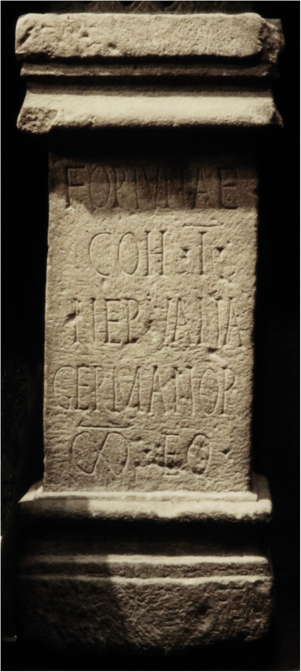
An issue has also arisen recently with the reading of the numerals on the slabs from Braidfield and Old Kilpatrick, the latter generally assigned to Dalnotter, both recording work by the Sixth Legion (Fig. 4).Footnote 72 Campbell suggests that, rather than recording lengths of 3,240 and 4,141 feet (P /X//X//X/CCXL and P (X)(X)(X)(X)CXLI), they should be read as 30,240 and 40,141 feet respectively.Footnote 73 In support of her claim, she refers to Appendix VI in the Oxford Handbook of Roman Epigraphy, which adds (X) to ((/)) and barred X as a variant symbol for 10,000.Footnote 74 But the Handbook cites no instance, nor can we find one. The equivalent table of numerals in the Cambridge Manual of Latin Epigraphy lists only ((/)) and barred X for 10,000;Footnote 75 nor does Gordon mention (X) for 10,000 in his lengthy discussion of numerals in Roman inscriptions. For him, too, 10,000 is represented by ((/)) or barred X. 1,000 is ‘either a circle divided in half by a vertical line’ [(/)] ‘or a figure like an Arabic 8 on its side’ [∞].Footnote 76 Two ancient tabulations of numerals conveniently distinguish (/) = 1,000 from ((/)) = 10,000, the Paris abacus and a London writing-tablet.Footnote 77 Gordon adds that ‘the shape of the basic (/) varies considerably’.Footnote 78 When depicted in print, (X), |X| and ∞ look quite distinct, but it is difficult to differentiate between them when seen on the original inscriptions (compare Figs 3, 4 and 7). On the other hand, it is easy to see how the varying skills of the different stonecutters might result in variations in what were intended to be representations of the same symbol. Moreover, this symbol is often used to indicate the milliary strength of a unit. Examples include altars dedicated by cohors I Vardullorum at Lanchester and Castlecary; and a dedication slab erected by the same unit at High Rochester.Footnote 79 Also altars dedicated by cohors I Nervana at Birrens (Fig. 7); and the two building inscriptions from Salona dedicated by cohortes I and II Delmatarum (see Uniqueness, above) (Fig. 3).Footnote 80 Since ∞, however imprecisely depicted, is commonly used and is recorded in contexts where its interpretation is not in any doubt, there is no reason to suggest that the distances depicted by a version of that symbol on the relevant distance slabs should be increased tenfold.
Altar to Fortune from Birrens dedicated by cohors I Nervana Germanorum milliaria equitata (RIB I, 2093). Photo R.S.O. Tomlin.

Reliance on two-dimensional map measurement had previously been recognised as a problem when trying to determine the exact length of the Antonine Wall.Footnote 81 The LiDAR survey undertaken in 2010 finally allows the topographic undulations along its line to be taken into account and has resulted in an increase in the established length of the Wall from 60.24 km to 62.03 km.Footnote 82 There seems little doubt that this is likely to provide a more accurate representation of its length as perceived by the Roman legions during its construction, given the character of the measurement methods they would have employed (see Units of measurement, above). Hannon et al. go on to compare the sectors of the Wall built by each legion recorded on the distance slabs with these more accurate three-dimensional measurements from the LiDAR survey, in order to determine which of the two versions of the Roman foot attested in the north-west provinces had been used for its construction. They conclude, contrary to previous assumptions, that it was the slightly longer pes Drusianus rather than the pes Monetalis.Footnote 83 However, there are major problems with the methodology employed in the original paper that call into question its primary conclusion and, by extension, cast doubt on the proposed wider implications.
Fundamentally, there is a mathematical error in the equivalence figure used to convert the pes Drusianus into metres. Though the authors quote the figure of 0.332 m in their text, the conversions provided in their tables 1 and 2 seem to be using a different, lesser figure approximating to 0.307 m (compare our Table 3, above).Footnote 84 As a result, all of the pes Drusianus metric conversions are too short, though those for the pes Monetalis are broadly correct.
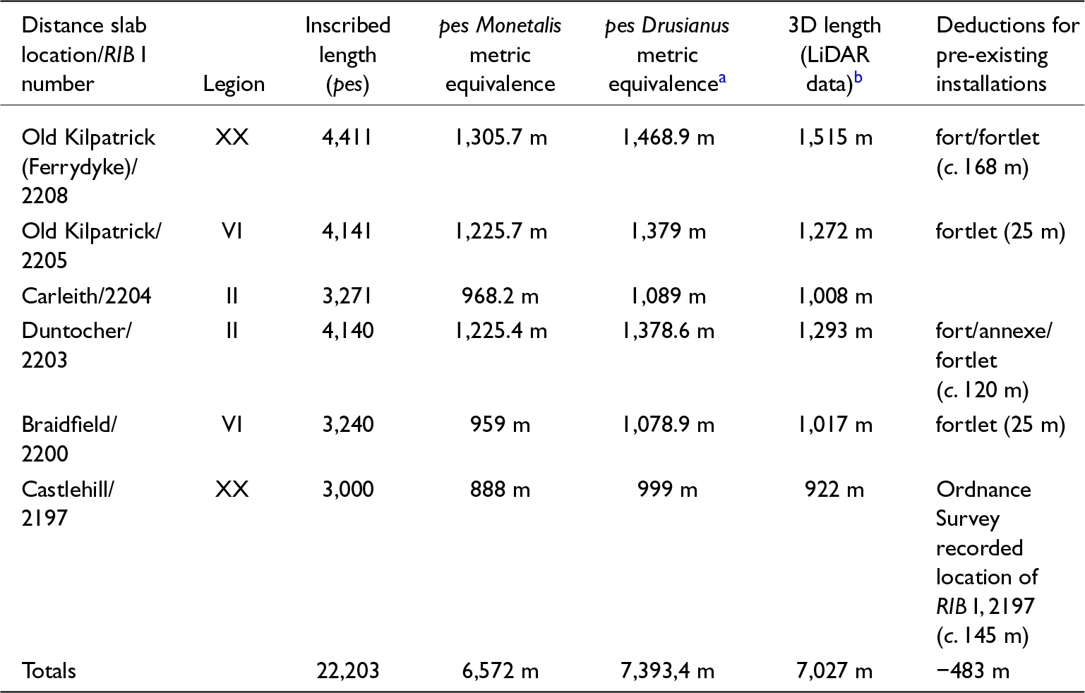
A comparison of the three-dimensional lengths of the six most westerly building sectors of the Wall with the lengths recorded on the relevant distance slabs, expressed in both pedes Monetales and the pedes Drusiani (after Hannon et al. Reference Hannon, Rohl and Wilson2017, with some corrections and additions).

(a) The equivalence figures have all been re-calculated using a conversion factor of 0.333 m.
(b) The postulated locations of the distance slabs and the three-dimensional distances between them are taken from Hannon et al. Reference Hannon, Rohl and Wilson2017, table 2.
We do not have a full set of distance slabs covering the total length of the Wall, nor do we know the original locations of all the slabs that have been found. However, we do have sufficient data from the most westerly 7 km (measured along the Wall line) to establish with confidence which unit of measurement was being used. Distance slabs recording the legion responsible for the work and the distance built in pedes survive for each of the six short sections between Castlehill and the Clyde at Old Kilpatrick, with even some duplicates (Table 3).Footnote 85 We also have a precise record from the first-edition Ordnance Survey mapping of the discovery location of the most easterly of this group of slabs on the line of the Wall some 145 m south-west of the fort at Castlehill, and we know to within a few metres the point at which the Wall reached the north bank of the Clyde. Finally, we know from excavation and survey both the size and the location of virtually all of the installations that had already been built prior to the construction of the rampart that links them.Footnote 86 It has long been realised that the frontage they represent would not then have been included in the distances subsequently recorded on the slabs,Footnote 87 so we can use that information to adjust the figures.
The correlation between the individual building sections recorded on the slabs is generally not close for either the pes Monetalis or the pes Drusianus (Table 3), which calls into question the accuracy of the postulated start and end points of those sectors on elevated hilltop locations.Footnote 88 Indeed, Hannon et al. make clear that these positions were determined by an iterative, best-fit process that would seem to have involved a substantial element of circular reasoning.Footnote 89 However, as already noted, both ends of the most westerly six-section block are known with a considerable degree of confidence, so the total figures may reasonably be relied upon. Examination of these makes it clear that the overall distance provided by the pes Drusianus conversion considerably exceeds (by over 366 m) the corresponding three-dimensional distance (Table 3). If deductions from that measured distance are then made to allow for the pre-existing structures (c. 338 m), that excess figure further increases to over 700 m. By contrast, the same deduction calculation brings the three-dimensional LiDAR distance to 6,689 m, within 117 m of the pes Monetalis conversion figure. If a further deduction of c. 145 m is made, better to reflect the discovery location of the distance slab recorded by the Ordnance Survey to the west of the fort at Castlehill rather than the change in direction of the Wall by its north-west corner, as was assumed by Hannon et al.,Footnote 90 the correspondence comes to within 28 m. This would seem to confirm that the unit of measurement employed was, in fact, the pes Monetalis.
It is not yet possible to extend this detailed reassessment further to the east because there are too many variables involved, not least the increased levels of uncertainty about the original locations of the relevant distance slabs and debate over which installations may already have been built.Footnote 91 However, the general principle that the pes Drusianus conversion provides lengths well in excess of the three-dimensional distances involved still holds good. The general conclusion of Hannon et al. that it is necessary to include the frontage of all ‘secondary’ forts in the deduction allowance for pre-existing installations to make the figures on the distance slabs comply with the LiDAR measurements is one that can no longer be sustained.Footnote 92 As a result the concomitant implied contradiction of the Gillam hypothesis — that the Wall experienced a major change of plan during its construction — is no longer valid and there is no basis for the suggestion that the postulated ‘secondary’ forts must have been part of the original plan.
Allocation of labour
It is well established that the original intention was to divide up the Wall into a number of sectors to facilitate the most efficient division of building work between the three legions. This is particularly clear in the sector from Castlehill to the Clyde. As noted above (see Records of distance), the stratigraphic evidence shows that all the military installations in this sector were constructed before the rampart linked them,Footnote 93 indicating it was the last to be built. As has long been argued, the most likely explanation is that there had been a delay in the original building programme, though the reasons for that delay continue to be debated.Footnote 94 Nonetheless, the result was the further subdivision of the final sector of 4,440.6 paces into six much smaller sections, their lengths expressed in feet rather than in paces (see Units of measurement, above). These subdivisions were then allocated between the three legions in order to speed up the completion of the work and, as Macdonald demonstrated, the figures indicate considerable concern to ensure that the total distances for each legion were almost exactly the same (Table 3).Footnote 95
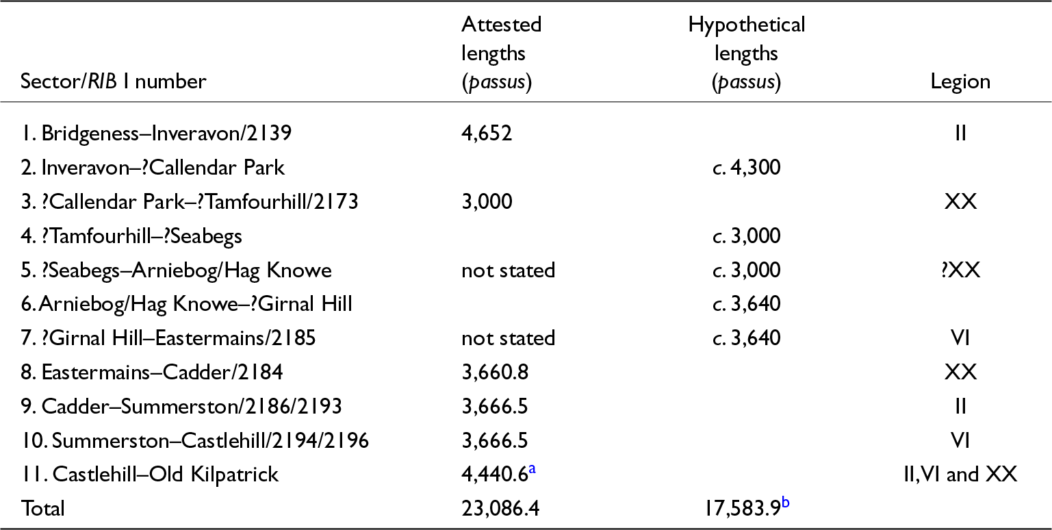
Elsewhere, apart from the most easterly sector starting at Bridgeness (see The eastern terminus of the Wall, below), we lack any certain record of the subdivision of work for approximately half of the length of the Wall, that is between Eastermains (near Kirkintilloch) and Inveravon.Footnote 96 Thus, the number of sectors originally intended remains uncertain, though the distance slabs attest to at least six and the recurrence of the figure of 3,666.5 paces suggests a concern to ensure an equality of allocation between the legions (see below and Table 4). On the basis of the known and presumed sites of forts, Macdonald proposed that the original plan involved nine sectors.Footnote 97 He went on to argue that this then had to be amended because of delays caused by the intractability of the basalt encountered across Croy Hill, though he provided no additional detail concerning the character of those amendments. This detail was subsequently suggested by Keppie, who differentiated between the sectors originally planned and those completed, adding a possible tenth to the latter that was itself later subdivided into six.Footnote 98 Keppie did note that this was merely a framework against which to test the data from other sources, but it has largely continued to be followed.Footnote 99 Hanson and Maxwell did attempt a detailed revision linked to the location of minor structures and temporary camps, suggesting an original 13 sectors,Footnote 100 but this was not altogether convincing.
Possible original legionary building allocations.

(a) Later subdivided into six sectors, divided equally between the three legions and measured in pedes (Table 3).
(b) This figure is arrived at by subtracting the attested lengths recorded on the distance slabs from the total length of the Wall indicated by the LiDAR data (62.03 km converted into Roman paces), with deductions (c. 888 m/685.6 paces) for pre-existing forts at Old Kilpatrick, Duntocher, Castlehill, Balmuildy, Auchendavy, Castlecary and Mumrills and for c. 38 of an assumed 40 fortlets (c. 950 m/642 paces), two fortlets having been subsumed into the allowance for the forts at Duntocher and Castlehill. It should, therefore, be assumed to represent a minimum figure.
Indeed, most previous attempts to define legionary work sectors have been over-influenced by assumptions about the probable relationship of their end points with military installations or notable topographic features, and such assumptions have sometimes resulted in questionable adjustments being made to primary locational information about distance slab discoveries (see Records of distance, above). However, the replication of very precise distances recorded on the slabs (Tables 3 and 4), such as 3,666.5 paces or 4,141 feet and their close correlates, attests to the relatively arbitrary location of the end points in relation to other structures. If we accept Hassall’s perceptive suggestion that the recurring figure of 3,666.5 paces be combined in each case with a distance of 3,000 paces,Footnote 101 it would represent the equal division of 20 Roman miles, approximately half of the length of the Wall, into three.Footnote 102 This, he argued, would have constituted a single block running eastwards from Castlehill and represent the work of all three legions in the first season of construction. However, the metric distance between the slabs at Eastermains and Arniebog/Hag Knowe does not readily subdivide into sectors of 3,000 paces (Table 4), even allowing for pre-existing primary installations. Maintaining consistency with the range of distances that are expressed in paces on the surviving distance slabs, the conclusion would seem to be that the original number of intended sectors was probably at least one more than is normally assumed.
Order of construction
The distance slabs provided the first evidence that the sector of the linear barrier from Castlehill to the Clyde was the last to be built, a conclusion which has since been confirmed by the stratigraphic evidence of the relationship between it and all the excavated forts and fortlets in that sector (see below and Allocation of labour, above). Macdonald took this to indicate that the Wall was built from east to west and this view has largely been followed thereafter.Footnote 103 That does not mean, however, that the work would simply have started at the eastern end and continued westwards, though this point is rarely made explicit. Indeed, Hassall has suggested that the work may have begun in the central sector, though his argument can no longer be sustained (see Allocation of labour, above).Footnote 104 Given the attested involvement of all three legions based in Britain, it is logical to assume that construction of the linear barrier would have begun simultaneously in three different locations in order to make most efficient use of the workforce and to complete the task as quickly as possible.
The construction of the linear barrier seems to have been organised separately from the various installations along it. Priority was given to the primary forts and probably the fortlets. Thus, the forts at Old Kilpatrick, Balmuildy and Castlecary were built as freestanding structures before the linear barrier joined them.Footnote 105 So, too, the forts at Auchendavy and Mumrills, as confirmed recently by geophysical survey.Footnote 106 Excavation at Duntocher in 1948–51 made clear that at least one of the ‘secondary’ forts pre-dated the Wall rampart and recent geophysical survey indicates that Castlehill probably falls into the same category.Footnote 107 However, both are located in the most westerly sector of the Wall that was the last to be built, so the principle cannot be extended to all ‘secondary’ forts. Indeed, several clearly post-date the linear barrier, hence the terminology applied to them, though the significance of the relevant stratigraphic evidence has been much debated of late.Footnote 108 All the fortlets were built at a very early stage in the construction programme and may have been constructed before the Wall rampart. Those excavated along the most westerly sector, such as Cleddans, were not only originally freestanding structures, but in two cases (Duntocher and Castlehill) preceded forts on the same site.Footnote 109 No fortlet anywhere can be demonstrated to post-date the linear barrier and two examples from the eastern third of the Wall (Seabegs Wood and Kinneil) are situated on slight salients, which suggests that their positions had been determined before its precise line had been established.Footnote 110
Advance preparation
It has long been considered likely that the distance slabs were largely prepared in advance, perhaps with space left for the distance to be added when it had finally been established.Footnote 111 Thus, in two cases, the first from Eastermains and the second probably from somewhere near Castlehill, no distance came to be inscribed, presumably as a result of oversight, haste or even completion in paint.Footnote 112 In other examples the numbers sit awkwardly in the space.Footnote 113 This is most evident on the slab from East Millichen, where the last four digits are reduced in size to squeeze them in. Similar problems can be seen on the examples from Summerston, where the last five digits spill over to end of the bottom line, or Cawder House, where the final S is squeezed up against the edge of the frame, though in the latter case the O at the end of Antonino in the second line suffers a similar fate. In another case from Castlehill the balance of the text looks odd as the numbers are not centred and there is considerable surplus space left at the bottom of the main panel.Footnote 114 Reference has already been made (see Uniqueness, above) to the consistency apparent in the form of the imperial dedication, which provides further support for their preparation in advance. Yet there is a potential inconsistency in this interpretation that is more difficult to explain. If the seemingly odd yet repeated allocation of 3,666.5 paces had been predetermined in order to divide up the work equally, there ought to have been adequate time to prepare the slabs accordingly. Yet these are precisely the slabs which reveal issues with the spacing of the numbers (see above). Perhaps here we are seeing the result of a conflict between intention and execution, i.e. that the intention was to apportion the lengths equally, but the precise allocation could only be recorded after it was completed.
Location of the eastern terminus
The precise eastern terminus of the Antonine Wall remains unconfirmed archaeologically and has been a subject of debate in recent decades.Footnote 115 It has long been located c. 2 km east of Bo’ness at Bridgeness, where the slab of that name, the largest and most elaborate of the distance slabs,Footnote 116 was found in 1868 on a rocky promontory c. 100 m from the mid-nineteenth-century shoreline. However, limited excavations in the 1980s failed to find any trace of the Wall in the immediate vicinity of the original discovery.Footnote 117 This stimulated the resurrection of a view held by some early antiquaries that the Wall may have continued on a more inland route for a further 1.6 km to the south-east as far as the fort at Carriden,Footnote 118 and prompted various forms of investigation to test this hypothesis. However, excavations designed to intersect alternative routes produced negative results, as did several magnetic survey transects; while examination of available aerial and LiDAR survey data failed to provide any convincing confirmation.Footnote 119
Like several other slabs, the excellent preservation of the Bridgeness stone attests to its protection from the elements on the abandonment of the Wall (see Disposal, above), and contemporary accounts of its discovery indicate that it had been buried face down in shallow topsoil, as is further confirmed by the ploughmarks identified on its rear side.Footnote 120 This is highly reminiscent of the circumstances of discovery of several other slabs that were buried in close proximity to the Wall (Table 2).Footnote 121 Given the early date and circumstances of most of the discoveries, it cannot be confirmed that all the slabs were found so close to the Wall, but, for those that were not, this is because they had either been re-used in another structure or curated after their discovery in recognition of their historical significance. In no case is there a parallel for a distance slab being moved more than 1 km, re-used and then reburied — let alone reburied in conditions that replicate those recorded in the initial accounts of the discovery of several other distance slabs.Footnote 122
Thus, the Bridgeness slab continues to provide the best positive indicator of the eastern terminus of the Wall. The topographic position of the line that it implies is entirely appropriate, allowing the Wall to continue along a natural promontory in order to descend more gradually to the coast from the c. 50 m contour that it had been following up to that point. Given the combination of intensive agriculture and occupation from the medieval period onwards in the immediate vicinity, it is not surprising that traces of the Rampart did not survive, while the Ditch would more sensibly have been positioned beyond the north-western side of the rocky promontory.Footnote 123
Conclusion
This unique group of monumental commemorative inscriptions continues to provide scope for investigation and analysis. While some recent considerations of the slabs have offered questionable new interpretations, all have given renewed impetus to their study, even if this has resulted in a stronger reassertion and clearer justification of previous interpretations. The establishment of a more accurate record of the length of the Wall, as it would have been perceived by the legionary builders, the correct recognition of the unit of measurement employed in its construction and the rejection of any direct link between the location of the slabs and other military installations along its line, offer hope for developing further insights in the future.
Acknowledgements
We are grateful to Dr Lesley Macinnes, Prof. David Breeze and Prof. Lawrence Keppie for their helpful and constructive comments on an earlier draft of this paper, and to the latter, the Hunterian Museum, University of Glasgow and the Archaeological Museum, Split, for kindly providing illustrations. Our thanks also to the anonymous referees for their stimulating comments.