1. Introduction
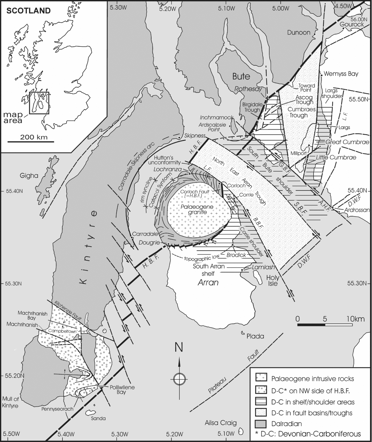
The diverse geology and striking landscapes of the Isle of Arran in SW Scotland (Fig. 1) have attracted Earth scientists for over 200 years. Arran includes rocks typical of the southern Highlands (metasedimentary rocks of the Dalradian Supergroup), and a more subdued (Lowland) terrane consisting mainly of Devonian, Carboniferous and Permo-Triassic rocks. The northern half of the island is dominated by high ground (up to about 900 m), occupied by the North Arran Granite Pluton (NAGP), which is one of several Palaeogene intrusions that are scattered along the west coast of Scotland (Emeleus & Bell, Reference Emeleus and Bell2005). Palaeogene magmatic activity is also expressed in the form of a volcanic ring complex near the middle of the island and by numerous dykes and sills that are exceptionally well exposed on the south coast of Arran. The purposes of this paper are to attempt to address two long-standing geological problems in the Arran area and surrounding parts of the Firth of Clyde (Fig. 1). These are as follows:
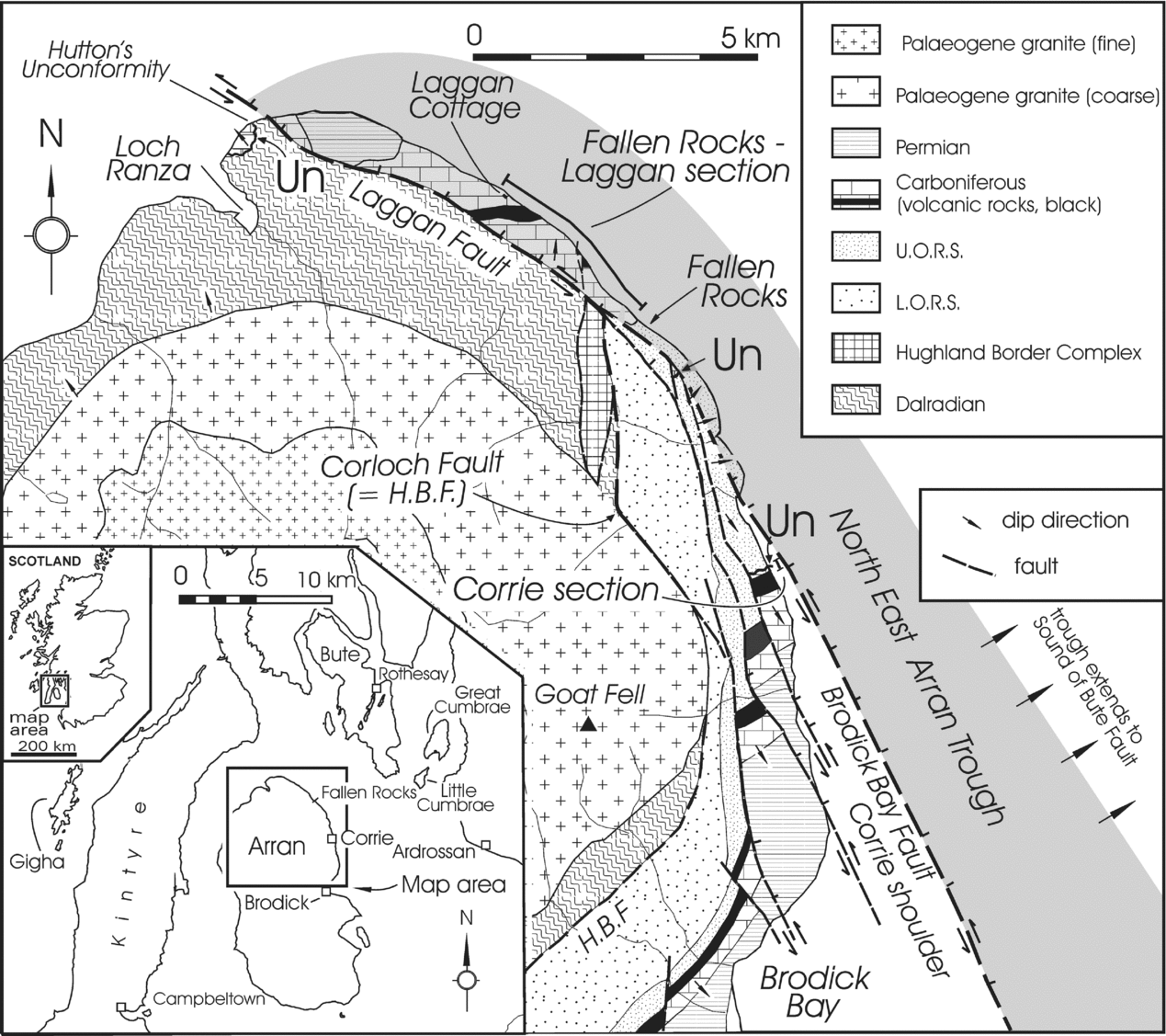
(1) Striking differences in stratigraphy and thickness of Lower Carboniferous (mainly Tournaisian) sedimentary successions in the Corrie area and in the adjacent coastal strip between Fallen Rocks and Laggan Cottage (Fig. 2).
(2) Uncertainties about the surface trace of the Highland Boundary Fault (HBF) in the Firth of Clyde area.
Sketch map of part of the Firth of Clyde to show the distribution of Dalradian and younger rocks. Fault-bounded troughs (based largely on geophysical data in McLean & Deegan, Reference McLean, Deegan, McLean and Deegan1978) are indicated by dotted ornament in the area northeast of Arran. The area designated Cumbraes Trough may include additional faults. Along the Laggan Fault (L.F.) and Brodick Bay Fault (B.B.F.) the NE Arran Trough and the Corrie ‘shoulder’ are juxtaposed. The proposed surface trace of the Highland Boundary Fault (H.B.F.) is also shown. Note that it is here proposed that the H.B.F. does not enter Arran on its NE coast but rather is relatively displaced to the NW by the bounding faults of the NE Arran Trough so that its first appearance in NE Arran is thought to be the fault-truncated northern end of the Corloch Fault. Other abbreviations: A.H.F. – Ardrossan Harbour Fault; D.W.F. – Dusk Water Fault; G.B.F. – Glencallum Bay Fault; S.B.F. – Sound of Bute Fault. See text for discussion.

Geological sketch map of NE Arran (modified from British Geological Survey, 1947, 1987) to show the location and geological setting of two measured stratigraphical sections of Lower Carboniferous (mainly Tournaisian) sedimentary rocks near Corrie and in the Fallen Rocks–Laggan area. These sections are shown in Figures 3 and 4. The thick Tournaisian succession in the Fallen Rocks–Laggan area is attributed to its location within the NE Arran Trough, whereas the Corrie section was formed in a marginal area here called the Corrie shoulder. Rocks of the two contrasted depositional settings are juxtaposed along the Laggan–Brodick Bay fault system. H.B.F. – Highland Boundary Fault; Un – localities displaying unconformable relationships between Tournaisian and Famennian (Upper Old Red Sandstone) or Dalradian rocks. These localities, which include Hutton's historical unconformity, are described in Jutras, Young & Caldwell (Reference Young and Caldwell2011). They are all considered to have been located on the Corrie shoulder, whereas a much thicker (mainly conformable) Tournaisian succession is preserved in the NE Arran Trough.

We propose that the solution to both problems is closely related to development of the Northeast Arran Trough, a fault-bounded depositional basin (mostly submerged) between Bute and NE Arran (McLean & Deegan, Reference McLean, Deegan, McLean and Deegan1978, fig. 8.1).
2. Previous investigations
Among several early investigations of the geology of Arran, some of the most detailed stratigraphical descriptions are those of Gunn (in Gunn et al. Reference Gunn, Geikie, Peach and Harker1903, for brevity hereafter referred to as Gunn, Reference Gunn, Geikie, Peach and Harker1903), who mapped the island during the last decade of the 19th century. He noted the pervasively faulted nature of the area and provided thickness estimates of Carboniferous rocks from the Corrie area and from the long coastal strip between Fallen Rocks and the northern tip of the island (Fig. 2). More recently the Palaeozoic history of the western part of the Midland Valley has been included in several regional studies such as those of Bluck (Reference Bluck, Bowes and Leake1978, Reference Bluck, Balance and Reading1980, Reference Bluck, Friend and Williams2000), Paterson, Hall & Stephenson (Reference Paterson, Hall and Stephenson1990), Monro (Reference Monro1999) and Browne et al. (Reference Browne, Dean, Hall, McAdam, Monro and Chisholm1999).
3. The Corrie area
On the coast just north of the village of Corrie (Figs 1, 2) there is a thin succession of Carboniferous sedimentary rocks that dip to the SE, in contrast to northeasterly-dipping strata in the Fallen Rocks area. Gunn (Reference Gunn, Geikie, Peach and Harker1903) suggested that the opposed dips demarcate a late, E-trending (and plunging) anticline, but the opposing dips might be due, in part, to juxtaposition of two formerly separate domains by transcurrent movements on the Laggan Fault, as discussed in Section 6.
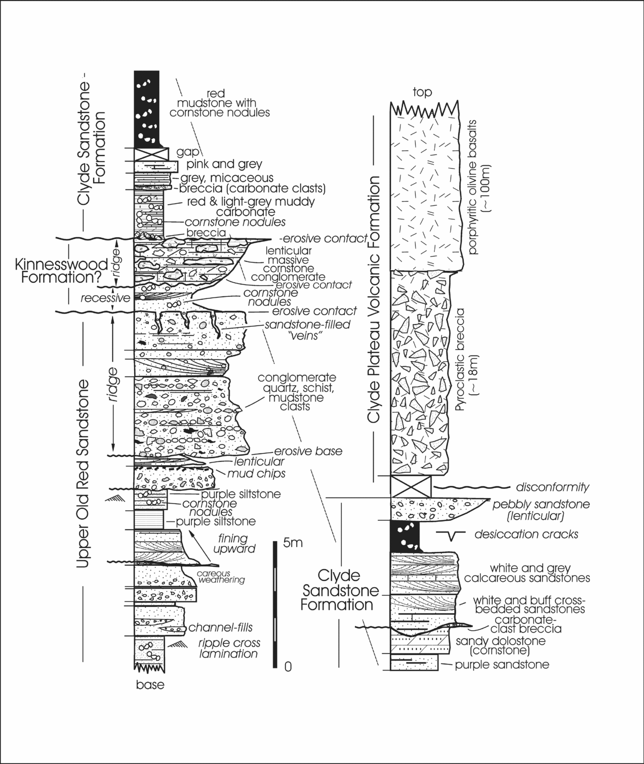
To document the stratigraphical successions of Lower Carboniferous rocks both in the Corrie area and in the coastal area between Fallen Rocks and Laggan Cottage, section measurements were carried out, using a 1.5 m measuring staff. The youngest unit of the Upper Old Red Sandstone (UORS) at Corrie is a ridge-forming conglomerate (Fig. 3) with clasts of white vein quartz, psammitic and pelitic rock fragments derived from the Dalradian Supergroup, and ragged intraformational fragments of maroon mudstone and pink sandstone. The top of the conglomerate is penetrated, to a depth of a few tens of centimetres, by thin ‘veins’ filled with red, granule-bearing mudstone, derived from the overlying Lower Carboniferous sedimentary succession. The sedimentary veins suggest that the surface of the UORS conglomerate was lithified and weathered prior to deposition of the Carboniferous sediments. Gunn (Reference Gunn, Geikie, Peach and Harker1903, p. 39) commented that the junction between the ridge of conglomerate (UORS) and overlying beds was ‘peculiar’ and considered it to be a ‘crush zone’ or unconformity. We consider the contact to be unconformable, following Jutras, Young & Caldwell (Reference Young and Caldwell2011).
Detailed representation of a measured section from the Corrie area (see Fig. 2 for location). Note the unconformable contact between coarse conglomerate of the Kinnesswood Formation and underlying rocks of the Upper Old Red Sandstone. All the sedimentary rocks above the unconformity and below the volcanic rocks of the Clyde Plateau Volcanic Formation have been identified as Kinnesswood Formation (British Geological Survey, 1987), but because of the resemblance of the rock types above the basal conglomerate to those of the Clyde Sandstone Formation elsewhere in the Firth of Clyde area, they are tentatively assigned to that formation. In both interpretations the Ballagan Formation is missing. Note that the Tournaisian rocks in this area are much reduced in thickness compared to correlative rocks in the coastal area immediately to the NW (see Fig. 4).

The conglomerate ridge of UORS is locally overlain by a more easily eroded bed of pink sandstone with yellow-weathering cornstone (caliche) nodules. This is succeeded by a massive, resistant, grey and pink conglomerate with elongate, carbonate-rich boulders and cobbles of grey pebbly conglomerate and sandstone, reworked from an older caliche (Jutras, Young & Caldwell, Reference Young and Caldwell2011). Both the caliche-nodule-bearing sandstone and the overlying boulder conglomerate diminish in thickness towards the SW (inland), probably as a result of palaeotopography on the sub-Tournaisian surface (Jutras, Young & Caldwell, Reference Young and Caldwell2011). The stratigraphical affinity of these rocks is uncertain but the British Geological Survey (1987) assigned them to the Kinnesswood Formation, which typically contains abundant cornstone nodules and beds (e.g. Tandon & Friend, Reference Tandon and Friend1989). At Hutton's unconformity near Lochranza (Figs 1, 2), similar beds are underlain by a massive carbonate-rich unit interpreted by Jutras, Young & Caldwell (Reference Young and Caldwell2011) as a phreatic caliche hardpan developed on a veneer of UORS and its Dalradian substrate (see also Anderson, Reference Anderson1947; Young & Caldwell, Reference Young and Caldwell2009).
The upper contact of the caliche-rich conglomerate near the base of the Kinnesswood Formation is also problematic. Gunn (Reference Gunn, Geikie, Peach and Harker1903) favoured a fault boundary but the field evidence is not convincing. The massive cornstone conglomerate is succeeded by red and light-grey mudstones and grey micritic carbonates, with breccia at the base. There follows a succession of white- and buff-weathering cross-bedded sandstones alternating with red and purple silty mudstones containing white and yellow caliche nodules. White-weathering, soft, slightly calcareous, cross-bedded sandstones and thin, discontinuous beds of carbonate-clast-bearing breccia, resemble those in the lower part of the Clyde Sandstone Formation in Millport Bay on Great Cumbrae, and on south Bute. In the third edition of the geological map of Arran (British Geological Survey, 1987) all of the sedimentary beds in the Corrie area, between the UORS and lavas of the Clyde Plateau Volcanic Formation (hereafter CPF), were assigned to the Kinnesswood Formation. If, as suggested in Figure 3, the sedimentary rocks immediately underlying the CPF at Corrie are part of the Clyde Sandstone Formation, then that unit is much reduced in thickness (about 14 m), compared to its development in the Fallen Rocks–Laggan area (>160 m). If the sedimentary rocks between the UORS and the CPF are all part of the Kinnesswood Formation, then both the Ballagan Formation and the Clyde Sandstone Formation are absent. A comparably thin (< 20 m thick) development of the Clyde Sandstone Formation is preserved beneath lavas of the CPF throughout south Bute (Young & Caldwell, in press). The south Bute peninsula provides a good analogue for the Corrie area, but it lies on the opposite side of the NE Arran Trough (Hall, Reference Hall, McLean and Deegan1978) (Fig. 1). Quite different stratigraphical relationships are preserved in two small fault-bounded basins near the HBF in central Bute, where there is a conformable (interbedded) relationship between dark-grey and green carbonaceous mudstones of the Birgidale Formation (Paterson & Hall, Reference Paterson and Hall1986) and volcanic rocks of the CPF. A similar succession in the Fallen Rocks–Laggan area of Arran (Fig. 2) shows that the Laggan Mudstone Formation (probable Birgidale equivalent) has a similar interbedded relationship with the overlying CPF. These plant-rich, carbonaceous mudstones and thin coals are restricted to several small, fault-bounded Early Carboniferous basins in the Firth of Clyde area, where contemporary subsidence led to development and preservation of a conformable contact with volcanic rocks of the CPF.
4. The Fallen Rocks–Laggan area
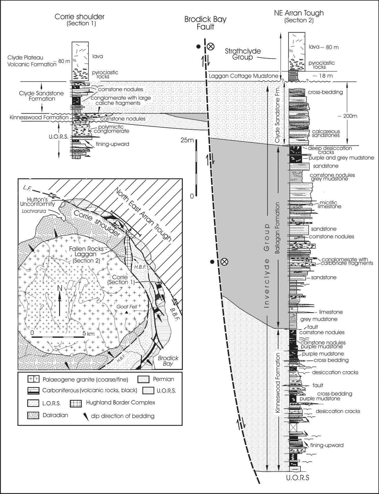
The thickest succession of Lower Carboniferous rocks on Arran is in the coastal area between Fallen Rocks and the northern tip of the island (Fig. 2), but because of faulting, related in part to emplacement of the Palaeogene granite pluton, the stratigraphical succession can only be pieced together from several partial sections. A simplified version of the (incomplete) stratigraphical succession in this area is shown in Figure 4 (Section 2). The measured section includes rocks of the Inverclyde Group, which, in ascending order, comprise the Kinnesswood, Ballagan and Clyde Sandstone formations (Paterson & Hall, Reference Paterson and Hall1986; Browne et al. Reference Browne, Dean, Hall, McAdam, Monro and Chisholm1999; Read et al. Reference Read, Browne, Stephenson, Upton and Trewin2002), overlain disconformably(?) by the Laggan Cottage Mudstone Formation, which has a conformable (interbedded) relationship with overlying pyroclastic rocks and basaltic lavas of the CPF. The Laggan Cottage Mudstone Formation was placed, together with the CPF, in the Viséan Strathclyde Group (Paterson & Hall, 1989).
Measured sections from the Corrie area (Section 1; see Fig. 3 for more detail) and the Fallen Rocks–Laggan area (Section 2) to show the markedly thicker and more complete Lower Carboniferous (mainly Tournaisian) succession in the latter area. Inset (modified from British Geological Survey, 1947, 1987) shows the interpretation of the coastal area of NE Arran as part of the NE Arran Trough, whereas the area on the SW side of the Brodick Bay Fault (B.B.F.) and its NW extension as the Laggan Fault (L.F.), is thought to have formed on the relatively elevated Corrie shoulder on the SW margin of the depositional basin. See text for detailed discussion. Circled X near Brodick Bay Fault indicates sense of transcurrent movement (away from the observer); large dot indicates movement towards observer.

The Kinnesswood Formation comprises a series of fining-upward cycles, made up of pebbly, red sandstones overlain by siltstones, capped by red, silty mudstones. The fine-grained rocks contain abundant caliche, in the form of carbonate nodules and layers (Tandon & Friend, Reference Tandon and Friend1989).
The dominant lithology of the overlying Ballagan Formation is grey and black mudstone with fragmented plant remains and, in some places, a fauna of ostracods and fish remains (Gunn, Reference Gunn, Geikie, Peach and Harker1903; Matheson, Reference Matheson1963; Stephenson et al. Reference Stephenson, Williams, Monaghan, Arkley and Smith2002). It also includes subordinate thin sandstones, micritic carbonates (‘cementstones’) and conglomerates. The carbonate beds are commonly reworked into breccias and conglomerates.
The succeeding Clyde Sandstone Formation is mainly grey and white, slightly calcareous, cross-bedded sandstones and quartz-pebble conglomerates, together with mudstones, some of which contain white and buff caliche nodules. Because of its abrupt nature, the contact with the overlying Laggan Cottage Mudstone was tentatively considered to be disconformable by Paterson & Hall (Reference Paterson and Hall1986). The Laggan Cottage Mudstone is a thin unit of grey, carbonaceous mudstones, thin coals and minor fine sandstones. It has a conformable relationship with volcanic rocks of the CPF, which are overlain by a thick succession of younger Carboniferous sedimentary rocks including fossiliferous marine limestones (Gunn, Reference Gunn, Geikie, Peach and Harker1903; Leitch, Reference Leitch1941).
5. Variations in thickness and stratigraphy in adjacent areas
The total thickness of the sub-volcanic Tournaisian succession preserved near Corrie is only about 17 m, whereas in the Fallen Rocks–Laggan area, a few kilometres to the north, an (incomplete) composite measured section is about 330 m thick (Fig. 3). Contrasting thickness of the Lower Carboniferous sedimentary rocks in the two neighbouring areas was recognized over a hundred years ago (Gunn et al. Reference Gunn, Geikie, Peach and Harker1903). Early workers suggested that the Carboniferous igneous rocks at Corrie and in areas to the SW might be a large intrusive body, masking a fault, which could have cut out parts of the stratigraphy. As pointed out by Gunn (Reference Gunn, Geikie, Peach and Harker1903), these arguments are spurious, for the igneous rocks are clearly extrusive and the sedimentary rocks become progressively thinner as they are followed in a southwesterly direction towards Brodick until they are no longer present near the centre of the island and Permian strata lie directly on the UORS (Friend, Harland & Hudson, Reference Friend, Harland and Hudson1963). It was also pointed out by Gunn (Reference Gunn, Geikie, Peach and Harker1903) that there is marked thickening of all the Carboniferous stratigraphical units in the Laggan section, which, together with the introduction of more ‘marine bands’ in the post-volcanic Carboniferous succession there, argues for a stratigraphical rather than a structural explanation. The thickness differences between the two areas are best explained as the result of greater contemporary subsidence (accommodation) in the area on the NE side of the Laggan and associated faults, as suggested by Hall (Reference Hall, McLean and Deegan1978, p. 48), on the basis of seismic refraction studies in the mostly submerged NE Arran Trough.
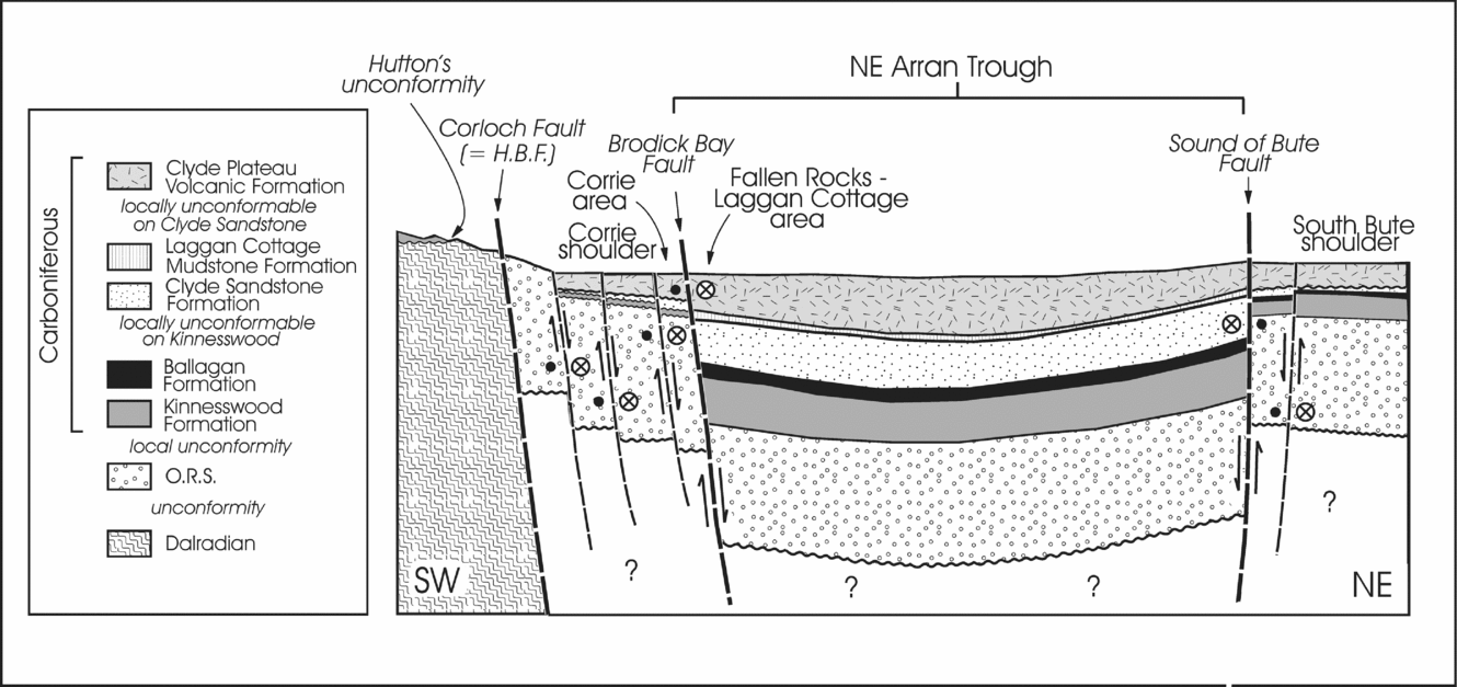
Southwest of Corrie (Fig. 2) several NW-trending faults throw down the strata to the NE, and probably also have a sinistral strike-slip component of movement. Published maps of the Fallen Rocks–Laggan area (British Geological Survey, 1947, 1987) show a large, gently curved fault (the Laggan Fault of Fig. 2), with similar throw, running parallel to the coast of the island and separating Dalradian rocks on the SW side of the fault from Devonian, Carboniferous and Permo-Triassic rocks on the coastal side. McLean & Deegan (Reference McLean, Deegan, McLean and Deegan1978), McLean & Wren (Reference McLean, Wren, McLean and Deegan1978) and Hall (Reference Hall, McLean and Deegan1978) identified a large NW–SE-trending fault (the Brodick Bay Fault) in the water-covered area east of central Arran (Fig. 1). The block between it and the sub-parallel Sound of Bute Fault, about 5 km to the NE, was interpreted as a basin or trough – the NE Arran Trough – which preserves a great thickness (about 1.5 km) of post-volcanic Carboniferous and younger sedimentary rocks (McLean & Deegan, Reference McLean, Deegan, McLean and Deegan1978). The Brodick Bay Fault runs ashore just north of the Corrie area (McLean & Wren, Reference McLean, Wren, McLean and Deegan1978, fig. 2.6; McLean & Deegan, Reference McLean, Deegan, McLean and Deegan1978, fig. 8.1; Hall, Reference Hall, McLean and Deegan1978; Woodcock & Underhill, Reference Woodcock and Underhill1987; England, Reference England1992) where its extension to the NW is known as the Laggan Fault. Although some workers have considered the Laggan Fault to be a Palaeogene structure related to emplacement of the NAGP, it was suggested by Leitch (Reference Leitch1941), mainly on the basis of abundant slump structures and clastic intrusions in the Carboniferous rocks on the NE side of the fault, that it was active in Carboniferous times. Thus the thick succession of Carboniferous rocks fringing the NE coast of Arran is considered to have been deposited in the NE Arran Trough (Figs 1, 2), juxtaposed, along the Laggan–Brodick Bay Fault, against a much-reduced succession at Corrie and in the central part of the island, which was located on the step-faulted, relatively high-standing southwestern shoulder of the NE Arran Trough. When comparing the succession in the NE Arran Trough with that at Corrie and farther to the SW, Hall (Reference Hall, McLean and Deegan1978, p. 48) mentioned ‘thinning of the Carboniferous against an Arran high’.
In a summary of the geological history of Arran (British Geological Survey, 1987) it was noted that ‘the early Dinantian rocks were affected by earth-movements’. In an attempt to explain the thickness changes between the Corrie and Laggan areas it was suggested that the Corloch Fault (part of the HBF system) was re-activated with a westerly downthrow, so that the Tournaisian succession east of the fault (Corrie area) was thinner and less complete than that on its west side (Laggan area). Such westerly downthrow is, however, difficult to reconcile with the fact that the exposed Corloch Fault separates young (Devonian and younger) rocks to the east from older (Dalradian) rocks to the west. The only exception to this is the presence of a small and thin outlier of Lower Carboniferous and Devonian(?) sedimentary rocks at Hutton's unconformity near Lochranza near the northern tip of Arran (Young & Caldwell, Reference Young and Caldwell2009; Jutras, Young & Caldwell, Reference Young and Caldwell2011). These thin successions and their unconformable relationships suggest that the area west and northwest of the Corloch Fault was uplifted rather than downthrown during Carboniferous times. Geophysical data published by McLean & Deegan (1978, fig. 8.1) and McLean and Wren (Reference McLean, Wren, McLean and Deegan1978, fig. 2.6) suggest that the submarine Brodick Bay Fault, which was considered by these authors to define the southwestern margin of the NE Arran Trough, continues on land to the NW as the Laggan Fault. Thus rather than using late movements on the HBF (Corloch Fault in this area) to explain the thickness variations of the Lower Carboniferous succession, we suggest that accommodation was provided by subsidence of the NE Arran Trough, bounded on its SW side by the Brodick Bay–Laggan Fault. According to this interpretation, the HBF is considered to have been displaced to the NW by later, sinistral transcurrent movement on the Laggan Fault (see Section 6 below and Fig. 1).
The Tournaisian succession in south Bute is also thin (< 100 m) and resembles that at Corrie, but these rocks were deposited on the opposite (northeastern) margin of the NE Arran Trough (Fig. 5). Similar fault-related thickness changes in Lower Carboniferous sedimentary formations have been documented on the mainland to the east (e.g. Paterson, Hall & Stephenson, Reference Paterson, Hall and Stephenson1990).
Schematic cross-section (not to scale) across the NE Arran Trough to show the dramatic changes in thickness and stratigraphy across the Brodick Bay–Laggan Fault. These differences are a consequence of greater accommodation in the NE Arran Trough than on the marginal area (shoulder) of the basin. The stratigraphy in the NE Arran Trough is extrapolated from the exposed succession between Fallen Rocks and Laggan Cottage. On the northeastern side of the NE Arran Trough the Sound of Bute Fault and associated faults separate the succession in the trough from a thinner sequence in south Bute. Note that the faults underwent normal, ‘down-to-basin’ movements to accommodate the marked thickness changes, but later transcurrent movements caused the NE Arran Trough (and the putative Highland Boundary Fault near its NW end) to be relatively displaced to the NW. The bounding faults (and possibly the trough itself) were subsequently deformed during emplacement of the North Arran Granite Pluton (Fig. 1). Circled Xs and large dots near faults indicate sense of transcurrent movements (see caption of Fig. 4 for explanation).

6. Surface trace of the Highland Boundary Fault in Bute and Arran
In parts of the Firth of Clyde, and especially in the area between Bute and Arran, the location of the HBF is uncertain. The HBF is an important and complex long-lived structural zone that played a key role in the geological development and definition of the Midland Valley of Scotland. The nature of the fault zone and its associated ophiolitic rocks is still being debated. Recent interpretations include the suggestion that the ophiolites are of ‘Ligurian-type’, representing embryonic oceanic crustal fragments associated with sub-continental lithospheric mantle exhumed during continental break-up and initiation of the Iapetus Ocean (Henderson, Tanner & Strachan, Reference Henderson, Tanner and Strachan2009). Alternatively, it has been suggested (Chew et al. Reference Chew, Daly, Magna, Page, Kirkland, Whitehouse and Lam2010) that parts of the Highland Border Ophiolite (e.g. in Bute) were emplaced during the earliest stages of closure of Iapetus, probably in latest Cambrian times. Bluck (Reference Bluck2010) proposed that the Highland Border Ophiolite is part of a separate terrane that was emplaced against the Dalradian terrane in mid-Palaeozoic times.
Regardless of its tectonic setting, there has been much discussion as to the surface trace of the HBF in the area SW of the island of Bute. The Firth of Clyde area is clearly anomalous in that the regional NE–SW trend of the HBF changes to a more NNE–SSW direction so that the Midland Valley of Scotland becomes narrower in the Firth of Clyde area and in Northern Ireland (George, Reference George1960, fig. 1; McLean & Deegan, Reference McLean, Deegan, McLean and Deegan1978, p. 107). It was suggested by George (Reference George1960), Max & Riddihough (Reference Max and Riddihough1975) and Chew (Reference Chew2003) that the HBF continues from SW Scotland into Northern Ireland near Cushendun and emerges in Clew Bay in west County Mayo. It has also been proposed that the HBF is part of a still-larger structure that can be traced into Newfoundland and the northern Appalachians as the Baie Verte–Brompton Line (Winchester et al. Reference Winchester, Williams, Max and Stall1992; Chew, Reference Chew2005).
The early history of the ongoing controversy concerning the surface trace of the HBF in the Arran area was documented by Friend, Harland & Hudson (1963, pp. 416–19). They were of the opinion that the HBF is not present in north Arran and suggested that it is represented there by a monoclinal structure. They carried out careful mapping of the poorly exposed area south of the NAGP and were persuaded that, at least locally (e.g. on the south side of Glen Rosa), the contact between Dalradian metasedimentary rocks and the Old Red Sandstone is an unconformity (Friend, Harland & Hudson, 1963, fig. 2). In some parts of north Arran the main fault of the HBF system may lie to the south of the Dalradian/ORS contact, as it does in south Kintyre (Fig. 1). In other areas it may be present at that contact, which is commonly obscured owing to poor exposure and alteration related to emplacement of the granite pluton.
Tanner (Reference Tanner2008, abstract) entertained the possibility that the HBF ‘terminates SW of Bute’. Part of the problem in Arran is that the Palaeogene NAGP occupies the area through which the fault would be expected to pass. In addition, the NE coast of Arran, where the fault should occur (Woodcock & Underhill, Reference Woodcock and Underhill1987, fig. 1), is occupied by a thick succession of Carboniferous sedimentary and volcanic rocks, which shows no indication of the surface expression of the regional structure. McLean & Deegan (1978, fig. 8.1) showed the HBF as continuing from the west side of Bute, at Scalpsie Bay, towards NE Arran, as did the British Geological Survey (1985), although the geophysical evidence does not support projection into the area SW of the Sound of Bute Fault (Mclean & Deegan Reference McLean, Deegan, McLean and Deegan1978, fig. 1; McLean & Wren, Reference McLean, Wren, McLean and Deegan1978, fig. 2.8). There is an ENE-trending fault at Ardscalpsie Point on the north side of Scalpsie Bay in west-central Bute (Fig. 1) where, as indicated by borehole data from just south of Inchmarnock (McLean & Deegan, Reference McLean, Deegan, McLean and Deegan1978, fig. 8.1; British Geological Survey, 1985), Carboniferous rocks appear to be preserved north of the expected surface trace of the HBF. The HBF could have been slightly displaced to the SE in this area by sinistral movement on the Glencallum Bay–Ardrossan Harbour Fault, as shown in Figure 1. Many authors have shown the HBF as intersecting Arran's NE coast, and passing through or under the Tournaisian sedimentary rocks occupying the coastal area NE of the Laggan Fault (Underhill & Woodcock, Reference Underhill, Woodcock, Jones and Preston1987; Woodcock & Underhill, Reference Woodcock and Underhill1987; Chew, Reference Chew2003; Tanner, Reference Tanner2007, Reference Tanner2008; Tanner & Sutherland, Reference Tanner and Sutherland2007; Henderson et al. Reference Henderson, Tanner and Strachan2009; Chew et al. Reference Chew, Daly, Magna, Page, Kirkland, Whitehouse and Lam2010; fig. 1 in all of these publications). George (Reference George1960, p.52) and McLean & Deegan (1978, p. 108) commented that the ‘disappearance’ of the LORS at the north end of the Corloch Fault (Fig. 1) indicated overstep of the Carboniferous rocks onto the Dalradian basement at the location of the HBF. In fact this relationship is not stratigraphical but structural, for juxtaposition of the Carboniferous succession of the coastal section against the ORS and Dalradian rocks is due to displacement on the Laggan Fault (Figs 1, 2). Such displacement may be quite large, for near the SE termination of the NE Arran Trough (Fig. 1) the submerged extension of the Dusk Water Fault, which was probably formerly aligned with the Plateau Fault (McLean & Deegan, Reference McLean, Deegan, McLean and Deegan1978, p. 107; fig. 8.1; British Geological Survey, 1985), displays a sinistral displacement of several kilometres. In addition, apparent sinistral displacement of volcanic rocks of the CPF between Corrie and their first occurrence in the Fallen Rocks–Laggan section on the NE side of the Laggan Fault is more than 6 km.
That the HBF was active in or later than Carboniferous times is shown by relationships in Bute and at Toward Point. On the north shore of Scalpsie Bay, to the NE of Ardscalpsie Point in west-central Bute and on the western margin of the Birgidale Trough (Fig. 1) the HBF separates Lower Carboniferous rocks, ranging from the Kinnesswood Formation to the CPF, from Dalradian rocks to the NW (British Geological Survey, 2008). About 10 km to the NE at Toward Pont (Fig. 1) a similar relationship is evident where rocks assigned to the Kinnesswood Formation are juxtaposed across the HBF, against Dalradian metasedimentary rocks (British Geological Survey, 2008), thus providing clear evidence that the HBF was not ‘dead’ by Carboniferous times.
Gunn (Reference Gunn, Geikie, Peach and Harker1903) was of the opinion that the HBF is present in Arran, running southward from the Corloch area (Fig. 1) as the Corloch Fault, which separates Dalradian gritty psammites and pelites, and lavas, mudstones and cherts ‘of supposed Arenig age’ (now considered to be part of the Highland Border Complex) from the ORS (Fig. 2). This view was endorsed by Anderson (Reference Anderson1947, p. 271), but neither he nor Gunn broached the question of the entry point of the fault on the NE coast of the island.
Some workers (Friend, Harland & Hudson, Reference Friend, Harland and Hudson1963; England, Reference England1992) have argued that the contact between the Dalradian and Devonian rocks on the south side of the NAGP is an unconformity rather than a fault, but Tyrrell (Reference Tyrrell1928) agreed with Gunn (Reference Gunn, Geikie, Peach and Harker1903) in carrying the HBF through Arran and in having it deflected and curved by the Palaeogene granite body. Bailey (Reference Bailey1926) also placed a fault between the Dalradian rocks and the ORS but was of the opinion that it was related to emplacement of the granite. George (Reference George1960, fig. 6) favoured continuity of the HBF from Corloch to Dougrie.
Gunn (Reference Gunn, Geikie, Peach and Harker1903) reported a large fault near Dougrie on the west coast of Arran, which he considered to be the continuation of the HBF. In their informative marine geophysical investigation, McLean & Deegan (1978, fig. 8.1) provided further evidence of a submarine fault emerging from the Dougrie area in western Arran, which they labelled as a ‘? continuation of the HBF (northern)’. They suggested (p.108) that the HBF may be ‘broken into segments by sinistral faults which step it to the south’, but they did not indicate how it might be connected to the main HBF zone, as exposed on land, either to the NE or SW. McLean & Wren (1978, p. 22) also considered the possibility that the HBF might continue to the SW, into the Dalradian rocks of Kintyre where it would be impossible to detect using gravimetric techniques. It has not been revealed in that area by geological mapping (British Geological Survey, 1996a,b).
The most recent map of Arran by the British Geological Survey (1987) does not depict the HBF on the NE coastal strip. The absence of the HBF at its ‘expected’ entry point on the NE Arran coast could be due to northwesterly (dextral) displacement along the Sound of Bute Fault (SBF, Fig. 1) so that the fault lies under water to the north of Arran. Complementary sinistral movement along the Laggan–Brodick Bay Fault (as also indicated by significant displacement of the Plateau–Dusk Water Fault; Fig. 1) may cause the HBF to first appear in NE Arran as the north end of the Corloch Fault (Fig. 1). The presence, in the Corloch area, of rocks resembling the Highland Border Complex in Bute and elsewhere (Tanner & Sutherland, Reference Tanner and Sutherland2007; Chew et al. Reference Chew, Daly, Magna, Page, Kirkland, Whitehouse and Lam2010) strongly suggests that the Corloch Fault is part of the HBF zone. This reconstruction is geometrically similar to that suggested by Tomkeieff (Reference Tomkeieff1961, fig. 5), but the major fault parallel to the coast of NE Arran (the Laggan Fault) is not considered to be part of the HBF, as suggested by Tomkeieff, but rather a portion of a fault defining the SW margin of the NE Arran Trough. Many authors have proposed that the HBF is present under the NE Arran Trough but this seems unlikely for the following reasons. The Lower Carboniferous sedimentary succession in the coastal area of Arran between Fallen Rocks and the north tip of Arran shows no sign of thinning, and although it is not fully exposed it appears to be stratigraphically complete, including the Laggan Cottage Mudstone, which passes conformably upwards into the CPF. These characteristics, including the presence of sedimentary rocks within the volcanic succession, are seen in fault basins elsewhere in the Firth of Clyde area such as the Birgidale and Ascog troughs in Bute (Young & Caldwell, in press) and partly in the Cumbraes Trough (Fig. 1). There are marked differences in marginal sequences such as those deposited on the Corrie and South Bute shoulders, and in areas on the NW side of the HBF such as the Machrihanish–Campbelltown area of south Kintyre (Fig. 1). These areas are characterized by condensed successions and local unconformities. In such areas the CPF typically has a disconformable base and lacks sedimentary interbeds. Thus the rocks in the coastal strip between Fallen Rocks and the northernmost tip of Arran are considered to have been deposited in the NE Arran Trough, as opposed to having formed on a shelf area to the NW of the HBF. The displaced segment of the HBF is thought to be located at, or close to, the NW boundary of the NE Arran Trough, as is the case in the Birgidale Trough in Bute and possibly in the Toward area (Fig. 1).
To the south of the NAGP the position of the HBF is uncertain (Friend, Harland & Hudson, Reference Friend, Harland and Hudson1963; England, Reference England1992), but since it appears to emerge on the west coast of Arran near Dougrie (George, Reference George1960; McLean & Deegan, Reference McLean, Deegan, McLean and Deegan1978), its most likely course around the south side of the granite is at, or near to, the contact between Dalradian and younger rocks (Fig. 1). Several Scottish Palaeogene central complexes are located on major Caledonian faults (Speight et al. 2002; Emeleus & Bell, Reference Emeleus and Bell2005), presumably because the crustal-scale faults facilitated the ascent of magma where they intersected SE-trending elongate magma reservoirs (Speight et al. Reference Speight, Skelhorn, Sloan, Knapp and Sutherland1982). The Palaeogene NAGP and the associated ring complex follow this pattern in being situated close to the HBF.
7. The Kintyre peninsula
Part of the scepticism regarding the presence of the HBF in Arran stems from the dearth of evidence for its existence in the southern part of the Kintyre peninsula (McCallien, Reference McCallien1927; Bailey, Reference Bailey1926). McLean & Deegan (1978, fig. 8.1) considered the HBF to continue southwestwards from the west side of Arran towards the Kintyre peninsula but they were unable to trace it to the SW and considered the possibility that it transects Dalradian rocks of the Kintyre peninsula, where it was not possible to detect it by geophysical means. It is likely that the HBF has been displaced southwards by one or more NW-trending sinistral transcurrent faults forming part of a regional set that dominates the structure of NE Arran (Gunn, Reference Gunn, Geikie, Peach and Harker1903; British Geological Survey, 1947, 1987) and south Bute (Smellie, Reference Smellie1916; British Geological Survey, 2008; Caldwell & Young, Reference Caldwell and Young2011; Young & Caldwell, Reference Young and Caldwell2011), to continue in a southwesterly direction to Northern Ireland from near the SE tip of Kintyre. Some of the strike-slip faults that are thought to be responsible for southward displacement of the HBF (Fig. 1) are projected seaward from faults shown in geological maps of the Kintyre peninsula (British Geological Survey, 1996a,b). The discontinuous (fault-fragmented) nature of the HBF in this region may have contributed to its weak geophysical expression. Alternatively, southward displacement of the HBF could have been the result of sinistral movements on a large, roughly N–S-trending fault between Arran and Kintyre, similar to those on Great Cumbrae and the mainland to the east (Fig. 1). The required displacement is, however, exceptionally large for a single fault in this area and no such structure was noted in the geophysical surveys of McLean & Deegan (1987). On the other hand the proposed set of smaller faults (Fig. 1) could easily have escaped detection. At the south end of the Kintyre peninsula a fault shown by McLean & Deegan (Reference McLean, Deegan, McLean and Deegan1978) between the Pennyseorach–Polliwillene area and the isle of Sanda might be the displaced southwestward extension of the HBF (Fig. 1). This interpretation is similar to that of George (Reference George1960) and Tanner (Reference Tanner2008).
8. The role of the North Arran Granite Pluton
Emplacement of the NAGP caused considerable deformation in the surrounding area (Fig. 1), as summarized by Underhill & Woodcock (Reference Underhill, Woodcock, Jones and Preston1987), Woodcock & Underhill (Reference Underhill, Woodcock, Jones and Preston1987) and England (Reference England1992). The deformation is expressed in a number of ways, including:
(1) Development or reactivation of numerous concentric and radial faults around the granite body (Woodcock & Underhill, Reference Woodcock and Underhill1987; England, Reference England1992).
(2) Curvature of Dalradian rocks (including development and deformation of the Catacol Synform) around the NW margin of the granite (England, Reference England1992).
(3) Curvature of the Laggan–Brodick Bay Fault, and possibly the entire NE Arran Trough, into a WNW direction from the original NW trend (England, Reference England1992, p. 608). Friend, Harland & Hudson (1963) considered most of the faulting in N Arran to be related to emplacement of the NAGP, and although the granite undoubtedly caused considerable deformation, much of which was accommodated by fault movements, it must be recognized that the surrounding region, well removed from the influence of the NAGP, shows clear evidence of complex and widely distributed older fault systems (McLean & Deegan, Reference McLean, Deegan, McLean and Deegan1978) (Fig. 1). Beyond the zone of deformation surrounding the granite it is possible that the faults delimiting the NE and SW margins of the NE Arran Trough continue in a NW direction in Loch Fyne (British Geological Survey, 1985).
(4) Development of a ‘rim syncline’ in Kilbrannan Sound to the NW of the pluton where Permian sedimentary rocks are preserved (McLean & Deegan, Reference McLean, Deegan, McLean and Deegan1978, fig. 8.1).
(5) Formation of the unusual arcuate coastline between Carradale and Skipness, near the outer zone of deformation by the granite (Fig. 1). Structural control on the coastal configuration is confirmed by the disposition of planar fabric (strike of bedding and schistosity) in the Dalradian rocks), which mimics the curvature of the coastline (British Geological Survey, 1996a).
9. Summary and conclusions
The problem posed by proximity of two strikingly different Lower Carboniferous successions at Corrie and in the Fallen Rocks–Laggan area of NE Arran can be resolved by invoking juxtaposition of the two areas, as a result of sinistral transcurrent movements on the southwestern bounding fault of the NE Arran Trough, a small, mostly submerged, NW-trending sedimentary basin between NE Arran and Bute. Movements on the Laggan Fault, which is the northwestern extension of the Brodick Bay Fault, together with complementary movements on the Sound of Bute Fault, could have caused the HBF to be displaced several kilometres to the NW in the area between NE Arran and the island of Bute. Thus the ‘disappearance’ of the HBF between the two islands might be explained by the fact that it lies under the waters of the Firth of Clyde, north of Arran. According to this reconstruction, the HBF does not enter Arran at the ‘expected’ point on its NE coast. Its surface trace may be displaced to the NW (along the Sound of Bute Fault) relative to its southwestward extension from Scalpsie Bay on the west side of Bute. The HBF, in NE Arran, may first appear some distance inland, as the fault-truncated northern end of the Corloch Fault. From western Arran the HBF is thought to be moved to the SW tip of the Kintyre peninsula by cumulative sinistral displacements on a series of small NW-trending faults that are part of a regionally developed set, for they have similar scale, sense, and geometry to those in NE Arran and south Bute. The proposed reconstruction provides a possible explanation for the change in direction of the HBF in the Firth of Clyde area and the attendant narrowing of the Midland Valley of Scotland.
Acknowledgements
We are grateful to the Natural Sciences and Engineering Research Council of Canada (NSERC) for financial support of part of this research. The conclusions reached in this paper were facilitated by discussions with H. W. Nesbitt and P. Jutras, for which the authors are grateful. We also extend our thanks to C. H. Emeleus and D. Stephenson for clarification of details shown on published geological maps of Arran. The manuscript was greatly improved by detailed and insightful comments by D. Stephenson and D. M. Chew.