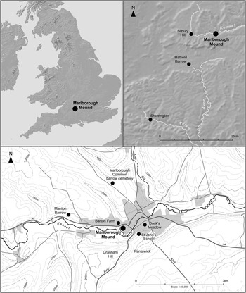


On the western side of Marlborough in Wiltshire within the grounds of Marlborough College public school is a large earthen mound (NGR SU 1837 6866; Scheduled Monument WI 321) (Fig. 1). At over 18 m high from the present surface, the Marlborough Mound is taller than the college buildings that crowd around the base, and it forces teachers and pupils to take a circuitous route between them. Indeed, the mound's huge mass, with a basal diameter of 83 m and 31 m across at the top, feels out of place within the school setting and is a reminder of earlier times when it formed a garden mount, and before that, the motte of medieval Marlborough Castle. As a result of the work reported on here, we now know that its origins were earlier still and that, like Silbury Hill which lies just 8.3 km to the west, it was constructed in the Neolithic period.
Location map showing the Marlborough Mound relative to Silbury Hill, Hatfield Barrow, Sherrington mound and other sites and rivers around it

The mound is located on first terrace valley gravels of the River Kennet, within the confluence of this river and a now canalised brook that formerly rose in Barton Dene near Barton Farm (Fig. 1) to the north. It is of similar form to Silbury Hill, in a comparable topographic location, and, although only a little over half its height, has widely been considered by researchers and the public alike to be a companion.
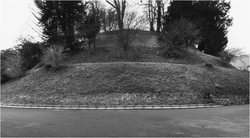
On the summit is a large 15 m diameter depression with a concrete base within which a 19th century water tank stood, although this has recently been removed. The sides, which support a number of trees, contain scars, one of which marks the line of a boiler-house flue, which led to a brick built chimney that also, until recently, stood on the summit. A spiral walkway a little over 1.5 m wide has been constructed around the mound, taking four circuits to reach the summit (Fig. 2). An 18th century grotto is cut into the base of the mound to the south and is itself scheduled, as is a belvedere constructed on one of the ledges formed by the walkway near the summit (Fig. 3). Concrete steps lead more or less directly up the south side of the mound to the summit and provide modern access. The base of the mound is currently surrounded by a relatively recent sarsen revetment wall, and the area immediately around it and over the backfilled ditch is laid to tarmac. The mound was surveyed in 1999 by the Royal Commission on the Historical Monuments of England (Field Reference Field1999; Field et al. Reference Field, Brown and Crockett2001); the resulting report provided accurate dimensions for the mound and included considerable research on its history.
The Marlborough Mound. View from south-east (James O. Davies, ©English Heritage)

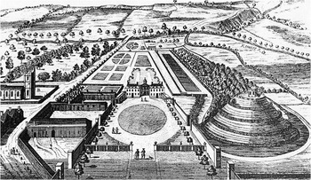
Stukeley's illustration of the Seymours’ house and gardens at Marlborough, which incorporated the mound, by now surrounded by a spiral path. Facing south. Note how the northern part of the mound ditch has been integrated into a water feature (from Stukeley Reference Stukeley1776)

As early as 1821 Richard Colt Hoare had suggested that the mound might be of prehistoric origin (Reference Hoare1821, 15); it subsequently entered the prehistoric literature as an enigma, with some authors feeling that, although there was potential for a prehistoric origin, there was no hard evidence (eg, Best Reference Best1997; Field et al. Reference Field, Brown and Crockett2001), while others have been more accepting (eg, Eve Reference Eve1892; Brentnall Reference Brentnall1938), and many have passed comment one way or the other without reviewing the evidence.
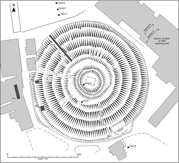
Brentnall, a schoolmaster at the college, outlined the history and archaeological evidence for Marlborough Castle (Reference Brentnall1912et seq.) and fuelled the case for prehistoric origins on discovery of some antlers found embedded in chalk on the slopes of the mound. These were recovered during work for the above-mentioned boiler-house chimney that included cutting a channel up the north-western side of the mound for the flue in 1912 (Fig. 4). The antlers, which were recovered half-way up and several feet into the mound, comprised six fragments from red deer lying together:
‘three of these fragments consist of the burr and broken brow-tine, and two others seem to be consecutive portions of the beam of the antler to which one of the brow tines belonged. The largest fragment measured 246 millimetres (about 9½ inches) in circumference just above the burr’ (Brentnall Reference Brentnall1914, 112).
Hachure plan of mound showing core locations, 1960 watching brief, 1956, and 1955 investigations, and 1912 cutting

He suggested that it is:
‘unlikely that the fragments, which were thoroughly impregnated with chalk, could have been buried in that position at any date subsequent to the erection of the mound, and it is thought that their discovery may possibly throw some light on the question of the date of that work’ (Brentnall Reference Brentnall1914, 112; 1912, 24–5).
While cautious, given the proximity to Savernake Forest and aware of the royal hunting role that the site had played, he argued persuasively that they were pre-Norman and potentially of Neolithic date. Before this, in the 1890s, a single antler was found on the opposite side of the mound (Eve Reference Eve1892, 66), and again in the 1930s an antler tine was found ‘on the slope of the chalk 40yds [c. 36.6 m] to the north’ (Brentnall Reference Brentnall1938).
Brentnall also recorded the old ground surface during the 1912 investigation, which he noted gently sloped from the north to the south and appeared alluvial. At the base, the mound was excavated into by 14 ft (4.2 m), allowing Brentnall to see a thin layer of charcoal overlying the old ground surface. This in turn was covered by ‘½ inch (150 mm) of ‘reddish clay’, containing a few broken flints, showing surface exposure, and some tertiary flint gravel pebbles’ (Brentnall Reference Brentnall1914, 112). These layers deepened towards the interior of the mound, and above this was the mound material.
However, in 1955, excavations on the western side of the mound (Fig. 4) found medieval refuse, including Norman pottery, overlying the old ground surface. A second trench in 1956 cut 2.1 m into the side of the mound confirmed this stratigraphy and produced further Norman pottery (Hayman Reference Hayman1956, 14–5).
Best (Reference Best1997) reviewed the evidence for a prehistoric date for the mound and concluded that, although large, it does fit within the size range for medieval mottes, while Field et al. (Reference Field, Brown and Crockett2001) pointed to the topographical comparisons with Silbury Hill, particularly of the adjacent springs, but, considering the presence of the Norman pottery and the lack of prehistoric material, concluded that ‘in the absence of data to the contrary, the available archaeological and documentary evidence indicates that the mound is essentially a medieval construction’ (2001, 203). The 2001 Archaeological Research Agenda for the Avebury World Heritage Site summed up the situation as: ‘it would appear, however, sensible to reserve judgement until the date of antlers associated with the mound are known’ (Cleal & Montague Reference Cleal and Montague2001, 18).
The alignment of the Roman road between Marlborough and Silbury Hill has often been used to support an early date for the mound in that, like Silbury, Roman surveyors may have used it as a marker (Brentnall Reference Brentnall1938, 141). However, the exact location of the Roman road at this point is unknown (Margary Reference Margary1973, 135; Best Reference Best1997, 169) and it may have taken a more northerly alignment as an early medieval route appears to have done (Field et al. Reference Field, Brown and Crockett2001, 203), or indeed one to the south. Certainly, there was a Roman presence in the area. Stukeley believed that the mound lay on the site of a Roman fort and noted ‘Roman coins have been found in shaping the mount’ in the 17th century (Stukeley Reference Stukeley1776), indicating at least some pre-Norman activity. Two Roman coins and a possible pair of shears have been recovered from trenches cut into a nearby cricket field in 1892 (Eve Reference Eve1892, 66), while Brentnall (Reference Brentnall1938, 141) also described the discovery of Roman coins.
The mound was clearly used as the motte for a medieval tower, first of timber and then rebuilt in stone (Brentnall Reference Brentnall1938). The castle was ruinous by 1541 when Leland visited Marlborough (Toulmin Smith Reference Toulmin-Smith1964, 130), and Sir Francis Seymour had constructed a house in the grounds by 1621. The mound featured in hostilities during the English Civil War, used by both sides as the fortunes of war changed, and is likely to have been fortified during this time. By 1654, it was being used as a garden mount by the Seymours, who had landscaped it and cut or recut the spiral path terraced into the sides and leading to the summit (Field et al. Reference Field, Brown and Crockett2001, 197–202).
The ditch surrounding the mound is also likely to have been recut at this stage. Celia Fiennes, passing through at the beginning of the 18th century, described the mound surrounded by a canal that empties into a fishpond. This is a feature depicted by Stukeley (Fig. 3), who stayed at Marlborough House on a number of occasions and drew the house and gardens, showing the mound as an integral part of the garden layout. Clearly, the northern part of the ditch surrounding the mound had become incorporated into a formal geometric water feature by the 18th century and presumably this part had been scoured out for this purpose. The ditch was filled-in sometime before 1850, and during observations of the digging of foundations for the Victorian Physical Laboratory in the late 19th century over the ditch, a horseshoe and a portion of a glazed tile were recovered (Eve Reference Eve1892, 67). Brentnall recovered two Roman coins from the ‘castle ditch’ (Reference Brentnall1938, 141), probably residual although perhaps suggesting that not all of the ditch was recut. While in 1956, footings for new physics laboratories encountered a section of dressed sarsen stone masonry forming a 1 m wide north–south wall running along the line of the ditch a little under 10 m from the edge of the mound and interpreted as dating to the 17th century (Hayman Reference Hayman1956, 16–20). A new cart-shed was constructed in 1892 over the surrounding ditch and concrete was laid as the ground was described as ‘spongy earth and mud’ (Eve Reference Eve1892; Field et al. Reference Field, Brown and Crockett2001, 196). This also cut slightly into the northern side of the mound, which found that beneath the chalk at the base of the mound was a deposit of ‘stiff creamy clay’.
The 2010 Cores
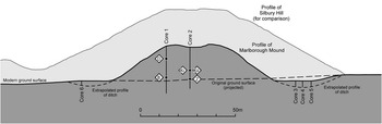
With fieldwork at Silbury Hill completed in 2008 and the post-excavation underway (Reference Leary, Field and CampbellLeary et al. in press), attention turned to the Marlborough Mound as a possible comparative site. With the antler and charcoal from previous excavations lost and in the absence of any other datable material from the mound, a project was developed to recover new material for dating and to investigate the structure of the monument. It was thought that cores taken centrally through the mound and the surrounding ditch could be analysed with a view to obtaining datable material (as well as providing details of the mound matrix and ditch fills). Funded by the Marlborough Mound Trust, Geotechnical Engineering Ltd were employed to drill two bore holes from the summit to the base of the mound, as well as a sequence of three bore holes on the north side of the presumed ditch, during the school half term in October 2010. It was hoped that a second sequence of three bore holes would also be taken through the ditch to the south, but in the event time pressures precluded this and only one core was taken from this area. Six cores were taken in total – Cores 1 and 2 through the mound, Cores 3, 4, and 5 through the ditch to the north of the mound, and Core 6 to the south (Figs 4 and 5).
Coring was carried out with 0.1 m diameter equipment and the summit cores were drilled to a depth of around 22 m, well into the natural chalk bedrock. The ditch cores were drilled from the modern ground level to 4 or 5 m below. All cores were removed in split-sleeved manageable lengths (generally 1.5 m), clearly labelled with start and finish depths for each segment, and taken to the English Heritage laboratories at Fort Cumberland, Portsmouth, where the core sleeves were sliced open and the material analysed. The cores were described using standard description methodologies of colour, matrix texture, stone content (size, shape, percentage), and inclusions, and interpretations made. Each segment was then photographed before sampling for assessment of palaeoenvironmental remains was carried out. The material within the cores was left largely intact throughout the work and subsequently the sleeves have been resealed and relabelled and returned to Marlborough College.
Small specialist samples were taken from various points within the cores where charcoal fragments were observed or where organic-rich deposits with the potential to contain macroscopic plant remains were encountered. The main purpose of these samples was to obtain material suitable for radiocarbon dating and to recover any biological or cultural remains. Samples were gently wet-sieved over a 250 micron mesh. Individual charcoal fragments were cleaned carefully under a dissecting microscope (×10–×40) to remove as much debris as possible. All charcoal fragments were left to dry slowly prior to identification. Charcoal fragments greater than 2 mm were identified with the aid of a high power light reflective microscope (×100–×500 magnification) using standard techniques and with reference to identification manuals (Schweingruber Reference Schweingruber1982; Gale & Cutler Reference Gale and Cutler2000; Hather Reference Hather2000). While the majority of the samples were devoid of biological remains or contained charcoal fragments that were too small for identification, Samples B, D, F, J, and Ki and Kii contained charcoal fragments greater than 2 mm, while Sample Z produced a considerable variety of remains in addition to charcoal (see below).
Six charcoal fragments from Samples B, D, Ki and Kii, and Z (Fig. 5) were submitted to the Scottish Universities Environmental Research Centre (SUERC) and Oxford Radiocarbon Accelerator Unit (ORAU) for radiocarbon dating. The five samples dated at SUERC were pre-treated using the acid-base-acid method (Stenhouse & Baxter Reference Stenhouse and Baxter1983). CO2 from the pre-treated samples was obtained by combustion in pre-cleaned sealed quartz tubes (Vandeputte et al. Reference Vandeputte, Moens and Dams1996) and the purified CO2 was converted to graphite (Slota et al. Reference Slota, Jull, Linick and Toolin1987). The samples were measured by Accelerator Mass Spectrometry (AMS), as described by Xu et al. (Reference Xu, Anderson, Bryant, Cook, Dougans, Freeman, Naysmith, Schnabel and Scott2004). The sample processed at ORAU, which was dated twice as part of internal laboratory quality assurance procedures, was pre-treated using a standard acid-base-acid method (Brock et al. Reference Brock, Higham, Ditchfield and Bronk Ramsey2010), combusted, converted to graphite, and dated as described by Bronk Ramsey et al. (Reference Bronk Ramsey, Higham and Leach2004).
Profile through the Marlborough Mound, with the profile of Silbury Hill behind, showing cores and location of dating samples

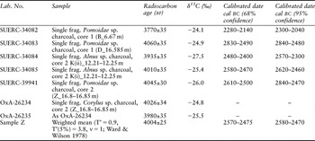
Both laboratories maintain a continual programme of quality assurance procedures, in addition to participation in international inter-comparisons (Scott Reference Scott2003; Scott et al. Reference Scott, Cook and Naysmith2010), which indicate no laboratory offsets and demonstrate the validity of the precision quoted. The radiocarbon results are given in Table 1, and are quoted in accordance with the international standard known as the Trondheim convention (Stuiver & Kra Reference Stuiver and Kra1986). They are conventional radiocarbon ages (Stuiver & Polach Reference Stuiver and Polach1977). The calibrations of the results, relating the radiocarbon measurements directly to calendar dates, are given in Table 1 and in Figure 8, below. All have been calculated using the calibration curve of Reimer et al. (Reference Reimer, Baillie, Bard, Bayliss, Beck, Blackwell, Bronk Ramsey, Buck, Burr, Edwards, Friedrich, Grootes, Guilderson, Hajdas, Heaton, Hogg, Hughen, Kaiser, Kromer, McCormac, Manning, Reimer, Remmele, Richards, Southon, Talamo, Taylor, Turney, Plicht, van der and Weyhenmeyer2009) and the computer program OxCal (v4.1) (Bronk Ramsey Reference Bronk Ramsey1995; Reference Bronk Ramsey1998; Reference Bronk Ramsey2001; Reference Bronk Ramsey2009). The calibrated date ranges cited in the text are those for 95% confidence. They are quoted in the form recommended by Mook (Reference Mook1986), with the end points rounded outwards to ten years. The ranges in Table 1 have been calculated according to the maximum intercept method (Stuiver & Reimer Reference Stuiver and Reimer1986) with those in Figure 8 derived from the probability method (Stuiver & Reimer Reference Stuiver and Reimer1993).
Radiocarbon Dates from the Marlborough Mound

Summary of the mound sequence (Cores 1 and 2)
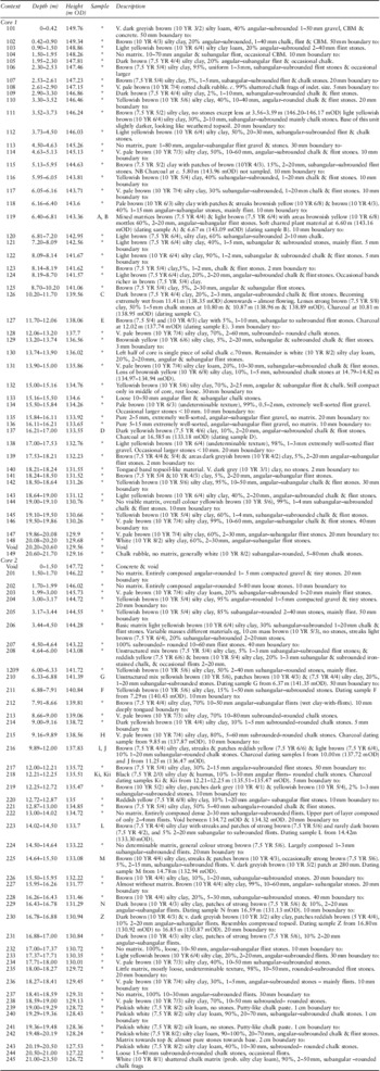
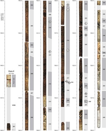
The following is a general summary of the stratigraphy represented in the cores (see Table 2 for detail, and Figures 6 and 7).
Context Index And Description

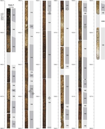
The complete Core 1 sequence as seen. Annotated with context information

The complete Core 2 sequence as seen. Annotated with context information

Natural Deposits
Cores 1 and 2 penetrated to a considerable depth below the natural ground (with Core 2 going deeper since it was drilled from a lower level on the summit). Core 2 (the more central of the two cores) recorded solid chalk at 126.72 m OD (context [245]), overlain by a pinkish white putty-like chalk paste and rounded chalk stones to a level of 129.13 m OD ([244]–[238]). Overlying this was a 0.18 m layer of pure flint gravel ([237]), followed by a thin layer of chalky clay ([236]), and then further flint gravel ([235]), pale silty clay ([234] and [233]), and then another layer, this time 0.37 m thick, of pure flint gravel (context [232]), bringing it to a height of 130.72 m OD. These layers of flint gravel presumably represent washed-in valley gravel mixed with chalk and clay, although they are impossible to define with any certainty.
Core 1 recorded solid chalk at a level of 129.16 m OD (context [149]), which was overlain with chalky clay ([148] and [147]), and then a layer of flinty gravel ([146]) at a level of 130.26 m OD, presumably again representing valley gravels. Over this was a layer of yellowish brown silty clay ([145]) and a 0.1 m layer of fine flint and chalk stones ([144]), followed by a further sequence of silty clay ([143]) and (larger) chalk and flint stones ([142]), bringing the sequence to a level of 131.26 m OD.
Old Ground Surface and Earliest Mound Material
In Core 2, overlying the natural ground is a dark brown layer of silty clay (context [231]) overlain by another ([230]), possibly representing compressed topsoil, and recorded at a height of 130.94 m OD. A sample of this material was taken at between 130.80 m and 130.87 m OD for environmental analysis and to recover material for dating (Sample Z) producing a wide range of remains including some macroscopic remains preserved as a result of anoxic conditions. A second sample was therefore retrieved from this level and processed in order to recover further material. The combined samples (total 0.02 litres) produced the following remains: 0.013 g mature deciduous oak, 0.084 g Pomoideae (hawthorn, crab apple, whitebeam, etc) and 0.056 g hazel (Corylus sp.) charcoal, an earthworm egg, one indeterminate insect fragment, a fragment of moss stem, an indeterminate Chenopodiaceae seed, two fragments of calcined bone, one piece of unburnt cortical bone, and one fragment of unburnt cancellous bone. As well as this, there were five small flint flakes, the largest measuring 5 × 5 mm and the smallest 2 × 2 mm. The smallest is a conchoidally fractured chunk with scars formed through percussion, while the others are all flakes with clearly defined striking platforms and ventral and dorsal surfaces. All of the pieces are typical of micro-debitage as generated through flint knapping, particularly platform trimming waste (although accidental creation through some other means cannot be ruled out). It is possible that this context might include a section through a turf and part of the old ground surface (although it is very hard to be sure in cores), given the concentration of charcoal remains, the presence of material such as unburnt and burnt bone, as well as struck flint. Therefore, this level may well be the base of the mound. Below this are natural deposits, and above are brown silty clay layers (contexts [229], [228], [226], and [225]) and a layer of flint gravel ([227]), which, although not provably anthropogenic, are nevertheless similar to the main body of the mound's construction (see below), and therefore interpreted as the earliest built layers of the mound. The top of these layers is recorded as 133.08 m OD. Samples of charcoal were recovered from context [229], dark brown silty clay layer at a level of 131.13 m OD (Sample N); and from brown silty clay layer [225] at 132.94 m OD (Sample M), neither of which was large enough for identification.
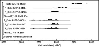
Two single fragments of charcoal from the possible old ground surface (Sample Z) were dated; the two measurements on a Corylus fragment (OxA-26234; 4026±34 bp and OxA-26235; 3980±35 bp) are statistically consistent (T’ = 0.9, T’(5%) = 3.8, ν = 1; Ward & Wilson Reference Ward and Wilson1978) and so a weighted mean was taken (Sample Z: 4004±25 bp) before calibration. This weighted mean and the measurement on a single Pomoidae fragment (SUERC-39941; 4045±30 bp) are statistically consistent (T’ = 1.1, T’(5%) = 3.8, ν = 1; Ward & Wilson Reference Ward and Wilson1978) and could, therefore, be of the same age. The latest of these results provides a terminus post quem for the start of construction of the mound of 2580–2470 cal bc (Sample Z; 95% confidence) (Fig. 8).
Probability distributions of dates from the Marlborough Mound. Each distribution represents the relative probability that an event occurred at a particular time. These distributions are the result of simple radiocarbon calibration (Stuiver & Reimer Reference Stuiver and Reimer1993)

Similarly, overlying the natural deposits, Core 1 recorded a layer of brown clay ([141]) overlain by a tongued band of topsoil-like material ([140]), recorded at a level of 131.55 m OD. This was overlain by a further thick layer of brown clay ([139]), bringing the sequence up to a height of 132.23 m OD. No samples were removed from the possible turf, but this may represent an old ground surface comparable to [230] in Core 2. Once again, however, caveats of working on the evidence from cores should be noted (see Canti & Meddens Reference Canti and Meddens1998).
First Possible Flood Event
In Core 1 the sequence of clay layers is overlain by a light yellowish brown extremely well-sorted flint gravel (1–3 mm) sequence (context [138]) a little over half a metre thick that becomes finer upwards to a level of 132.76 m OD. In Core 2, (that is, closer to the centre of the mound), a possibly comparable but much smaller deposit of 1–3 mm flint gravels was seen (context [224]) at a level of 133.22 m OD. It is difficult to interpret the fining upwards sequence seen in Core 1 as anthropogenically created and it must have been deposited during a significant erosion event (perhaps a local flash flood) that covered over the earlier built layers, including over the higher, more central deposits in Core 2.
Further Mound Material
A further thick clay layer recorded in both cores was deposited over the gravel sequence. In Core 1, this was a 0.79 m thick layer dark yellowish brown clay ([137]) recorded at a highest level of 133.55 m OD, and in Core 2 a 0.48 m thick layer of brown silty clay ([223]) at 133.70 m OD. Organic material was found occasionally in both these contexts and examined to identify charred or waterlogged remains of short-lived wood taxa: Sample D was recovered from [137] at a level of 133.18 m OD, and Sample L from [223] at level of 133.30 m OD. Sample D produced a result (see Table 1).
Second Possible Flood Event
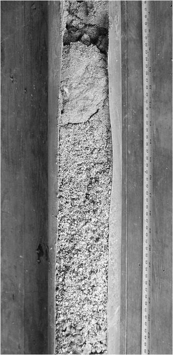
Between 133.55 and 134.26 m OD in Core 1 there was another deep sequence of naturally deposited (ie, not anthropogenically constructed) fining upward gravel and sand, the lowermost part of which (context [136]) was composed of stones up to 15 mm in size, blending into stones up to 5 mm (context [135]), while the uppermost part (context [134]) was as fine as 0.5 mm (Fig. 9). Core 2 replicates Core 1 in most respects including also having a fining upward sequence (albeit a far less definite one) between 133.70 and 134.32 m OD (context [222]). This sequence of fining upwards in Core 1 and probably also the weaker feature in Core 2 at the same level clearly indicates a depositional event of significant proportions that must have entirely obscured the earlier activity at the site. Both cores appear to contain construction material below the fining-upwards layer, but, in the absence of artefacts, we could only be sure of this interpretation by further excavation.
A close-up showing the second possible flood sequence in Core 1

Further Mound Material
Overlying the possible flood event is a series of layers, many metres thick, making up the body of the mound. They no doubt represent multiple phases of activity. In Core 2 they comprise layers of silty clay and gravel (contexts [221], [220] and [219]), followed by a very thin band of black silty clay and humus between 135.51 and 135.47 m OD (context [218]). Organic material was found in a dense mass in this context and two samples (Samples Ki and Kii) were obtained. They contained mature alder (Alnus sp.) and mature deciduous oak charcoal. Two alder charcoal fragments (one from each sample) were submitted for radiocarbon dating (see Table 1).
Over this were further thick layers of brown silty clay with varying levels of flint and chalk stone inclusions (contexts [217], [216], [214], [212]–[208], [206], and [203]), interleaved with layers of chalk rubble (contexts [215] and [213]), and pure flint gravel (contexts [207], [205], and [204]), bringing the mound up to a height of 145.73 m OD. Organic material was found occasionally although, after examination, proved unsuitable for dating. Samples I and J (the latter being mature deciduous oak (Quercus sp.)) came from context [216] at a level of 137.72 m and 136.47 m OD respectively. Sample H came from context [215] at a level of 137.87 m OD, while Sample F, also deciduous oak (Quercus sp.), came from context [211] at 140.43 m OD, and Sample G from [210] at 141.35 m OD.
Core 1 went through a similar, albeit longer, series of interleaved layers comprising silty clay and flints (contexts [131], [129], [127]–[123], [121]–[115], [111]–[109], [107], and [105]); pure flints ([133], [132], [113], and [106]); chalky clay ([128], [122], [114], and [112]); and chalk rubble ([130] and [108]). This took the mound up to a height of 147.81 m OD. Charcoal was also present in places throughout this sequence and was recovered from contexts [127] (Sample E, at 137.74 m OD); [126] (Sample C, at 138.95 m OD); and [119] (Samples A and B, at 143.16 m and 143.09 m OD respectively). Of these, only Sample B was of short-lived wood taxa suitable for dating (see Table 1). This was on a single fragment of Pomoideae charcoal. This is the highest point in the mound in which datable material was recovered (at a height of 143.09 m OD, ie, 11.54 m above context [140], the possible Core 1 old ground surface), confirming that at least the sequence up to that point is prehistoric. Given the similarity of the deposits overlying this and the lack of later artefacts such as fragments of brick or tile, it is thought that all the deposits, right up to context [105] (147.81 m OD), are all prehistoric in date. Again, assuming context [140] is the old ground surface, this would make the prehistoric mound at least 16.26 m high.
Historic Period Material
The sequence in Core 1 is overlain by a further 1.95 m of material, comprising flint gravel, silty clay, and silty loam (contexts [104]–[101]); however the presence of small fragments of brick or tile in these deposits suggests that they are of much later activity, possibly relating to the construction of the medieval tower, or perhaps even later.
The top levels of the prehistoric mound as well as any medieval activity are not apparent in Core 2 as the central area has been considerably truncated for the construction of the now dismantled water tower; the central part being lower than the surrounding area on the summit by at least 2 m. The uppermost contexts in Core 2 ([202] and [201]) are likely to be disturbed contexts relating to this work. The sunken area was sealed with a concrete and metal slab, which the core penetrated.
Summary of the ditch sequence (Cores 3–6)
Four cores were drilled through the surrounding ditch in 2010 as part of the coring exercise, a series of three to the north of the mound and one to the south (Fig. 4). Core 3 was drilled from a height of 129.59 m OD, Core 4 from 129.64 m OD, 5 from 129.58 m OD, and 6 from 130.26 m OD. To the north (Cores 3–5) these revealed an upper part (down to around 3 m) consisting of grey, brown, and white mixed deposits (unstratified) over around 0.50 m of grey silty clay loam (in one core topped with an 0.08 m dark soil layer), then down into white stony chalk slurry with occasional iron-staining and flints (to a depth of 5 m). The core to the south (Core 6) revealed about 0.70 m of brown silty clay loam becoming lighter with depth and merging into very pale brown (becoming white) chalk rubble (to a depth of 4 m). These deposits above natural ground can be characterised as ditch fills.
A Possible Section Through The Ditch On The North-East Side
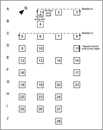
A possible section of ditch was recorded by one of us (PJF) on the north-east side of the mound in 1960Footnote 1. It was seen discontinuously in the north faces of seven of the numerous 4 ft (1.2 m) square holesFootnote 2 excavated to take the supports of a new, steel-framed refectory (now demolished) (see Fig. 10 for schematic plan of the square layout, and Fig. 4 for location).
Square layout during the 1960 watching brief of the refectory building

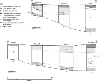
All the holes were examined, however cursorily, but the main effort in the short time available went into drawing two transects: a northern one (Section A) in three holes over 24 ft (c. 7.3 m) and, 18 ft (c. 5.5 m) to the south, a parallel row of four holes over 33 ft (10 m) (Section C) (Fig. 11). They recorded the layers in around 3–10 ft (c. 0.9–3 m) of made-up/deposited ground between the then present asphalted surface and chalk subsoil.
Section A taken from Squares 1, 2, and 3, and Section C taken from Squares 6, 7, and 8 (see Fig. 9)

The original field drawing and notes are entirely in pencil, and the notes include a consolidated descriptive list of eight layers observed in the sections, with suggested interpretations of layers 4 and 4a (respectively ‘original silt?’ and ‘weathered natural? or top of silt?’). This information is incorporated into the key to Figure 11, a key that subsumes most of the written information available. The original field drawing also includes the vital information about Square A1 (Fig. 10) that the section drawing is of its north face (here, the left hand part of Fig. 11 Section A) and that the east and south sides of the square, ie, NOT the drawn section: ‘show tip lines going S. and E. respectively ie prob[abl]y. foot of the mound.’
Small parts of built structures were recorded in three locations: ‘Squared stones’ were recorded at a depth of 8 ft (c. 2.4 m) along the east side of Square 11; ‘Brick work foundation’ was recorded in Square 14; ‘Brick wall foundation’ was recorded in Square 28. Further, a small number of finds were recovered; all now lost. The following is based on the original notes – and memory. The material consisted of: four potsherds, two of them probably prehistoric at a depth of 9 ft (c. 2.7 m) in Square 28, and one of them ‘green-glazed’ (probably 12th–13th century ad) at a depth of 6 ft (c. 1.8 m) in Square 7; a tile fragment (medieval or post-medieval) from Square 7; a clay pipe fragment (post-medieval) at a depth of 5 ft (c. 1.5 m) in Square 8; a fragment of glass bottle (post-medieval) at a depth of 4 ft (c. 1.2 m) in Square 28; an antler tine, presumed prehistoric, at a depth of 4½ ft (c. 1.4 m) from Square 8; bone fragments, unburnt and all probably animal, were recorded at depths of 6 ft (c. 1.8 m) in Square 7 and 8 ft (c. 2.4 m) in Squares 11 and 13; snail shells (unspecified) were recorded at a depth of 4 ft (c. 1.2 m) in Square 10 (Fig. 11).
Interpretation and discussion
The way in which the surface of the chalk subsoil drops from south-west to north-east in both sections A and C, particularly A, and the layering of its deposits, suggest the feature could well be a ditch of c. 48 ft (14.6 m) wide and 10 ft (3.0 m) deep. This depth is as recorded, while the width is inferential – doubling the 24 ft (7.3 m) actually recorded. That the feature is a ditch is, however, an assumption: without evidence of direction from the observations available, it might be one of several other possibilities, such as a large pit or quarry. It is probably not simply made-up ground since the layering is consonant with infilling of a hole of some sort.
One of the more intriguing observations made was of ‘grey mud (original silt)’ in the lowest deposit in the hypothetical centre of the ditch (layer 4; Fig. 11). This is not a normal ‘primary’ deposit in a chalk-cut ditch: was it an alluvial deposition or the result of a temporarily raised water table in situ? Perhaps the important point for now is to note that a layer exists in this area only some 3 m below the surface with a high environmental potential.
Whatever its nature and shape, the date of the ‘ditch’ is enigmatic. The main point of listing the few finds in some detail above is to suggest that the infilling, although consistent in its layering, has nevertheless been disturbed locally. The occurrence of an antler tine above a clay pipe fragment in Square 8 makes the point, as indeed does the appearance of the tine relatively high in Square 3 rather than on or near the subsoil surface (layer 5). Similarly, the appearance of ‘squared stones’ (from memory ashlar), 8 ft (2.4 m) down in Square 11, implies the digging of a considerable construction trench, though whether through undisturbed ground or existing deposits was not established. The structure may well be medieval in date, and Camden described the castle as ‘as heap of ruins: a few fragments of wall remain within the ditch’ (Reference Camden1610, 136). Alternatively it could be part of a similar wall as that recorded on the west side in 1956 (see above), tentatively dated to the 17th century (Hayman Reference Hayman1956), whilst there must be a distinct possibility that the ‘ditch’ itself is the ‘canal’ or garden water feature shown by Stukeley (Fig. 3).
Discussion
The dating of the Marlborough Mound to the second half of the 3rd millennium, with a terminus post quem for the start of its construction at 2580–2470 cal bc (Sample Z; 95% confidence), finally confirms that its origins are broadly contemporary with Silbury Hill. The four radiocarbon measurements from the mound itself are statistically significantly different (T’ = 39.0, T’(5%) = 7.86, ν = 3; Ward & Wilson Reference Ward and Wilson1978), and so represent a range of different actual ages. Given the difficulty of understanding the taphonomic relationships between these fragments of charcoal and the construction of the mound, it is probably safest to take the latest of these dates as a terminus post quem for completion. This is 2300–2040 cal bc (95% confidence; SUERC-34082), or 2280–2140 cal bc (68% confidence). Since all the dates fall in the second half of the 3rd millennium cal bc, it seems plausible that this date is not substantively earlier than the actual completion of this monument.
The, albeit imprecise, estimate for the date of the Marlborough Mound when compared to Silbury Hill (Reference Marshall, Bayliss, Leary, Campbell, Worley, Bronk Ramsey and CookMarshall et al. in press) and the Hatfield Barrow, the once sizable Neolithic mound within Marden henge in the Vale of Pewsey (Figs 1 & 12), suggests that these three mounds are broadly contemporaneous, and indicates that large-scale mound building, at least in this part of Wiltshire, has a late 3rd millennium cal bc currency. In order to evaluate the chronological relationship of these three mounds and further explore the exact timings of their building and the tempo of this activity (cf Bayliss et al. Reference Bayliss, Whittle and Healy2008) will, however, require at least small-scale excavation of the Marlborough Mound, as in order to fully exploit the potential of chronological modelling for producing robust date estimates (Bayliss Reference Bayliss2009) a thorough understanding of the both the taphonomy and stratigraphic relationship between samples is required.
The dating of the Marlborough Mound to the second half of the 3rd millennium cal bc means that we can now place it within the context of major monumental building practices taking place at Stonehenge (Marshall et al. Reference Marshall, Darvill, Parker Pearson and Wainwright2012) and Durrington Walls (Marshall et al. in prep.). With the completion of the mound at Marlborough, if one accepts the terminus post quem of 2300–2040 cal bc (95% confidence; SUERC-34082), and probably 2280–2140 cal bc (68% confidence), as being close to this event, being later than the Sarsens but potentially earlier than the Bluestone settings at Stonehenge. Completion of the mound also appears to be later than the introduction of Beakers in England (Fig. 12), but its initial phases could have been broadly contemporary with the appearance of this new material culture. These preliminary timings suggest that new ways of thinking about the temporality of monument building at the end of the Neolithic are required. In order to fully investigate the tempo of this activity we will be required to adopt a more robust approach to chronology.
Probability distributions of dates from the Marlborough Mound and of major archaeological events. These estimates are derived from the preferred chronological models for Beakers (Marshall in prep.), Durrington Walls (Marshall et al. in prep.), Stonehenge (Darvill et al. Reference Darvill, Marshall, Parker Pearson and Wainwright2012; Marshall et al. Reference Marshall, Darvill, Parker Pearson and Wainwright2012), Hatfield Barrow, and Silbury Hill (Reference Marshall, Bayliss, Leary, Campbell, Worley, Bronk Ramsey and CookMarshall et al. in press).

The mound
Although considerably smaller than Silbury Hill, the Marlborough Mound now ranks as the second largest Neolithic mound in Britain and possibly in Europe and, together, Silbury Hill and the Marlborough Mound represent an astonishing pair. The stratigraphy in the Marlborough Mound cores suggest that the mound was constructed over a number of phases rather than a single construction project, in a similar way to Silbury Hill, emphasising the significance of the process of construction over that of the final form (Leary & Field Reference Leary and Field2010; Reference Leary, Field and CampbellLeary et al. in press).
Given the medieval and post-medieval landscaping and modification, its original form can only be guessed at. The radiocarbon dates indicate the presence of Neolithic deposits to a height of 11.54 m and, accepting the nature of the succeeding material, it is suggested it may have reached 16.26 m. This is a substantial height and, given the likelihood of deep medieval disturbance for foundations of the tower and perhaps truncation of the original prehistoric summit, it may have been higher. The diameter of the mound is currently 83 m, but the excavations in 1955 and 1956 indicate that medieval deposits were present at ground level for at least 2 m into the mound; assuming that this continues around the base of the mound, it may represent a bracing or revetment. Certainly, there is documentary evidence of a ‘girth’ being placed around the motte (Brentnall Reference Brentnall1933, 75), presumably to arrest silting. Assuming that this was placed equally around the mound, subtracting these 2 m from each side of the base, the diameter can be guessed at something less than 79 m; slightly larger than the Hatfield Barrow, which measures around 70 m in diameter (Leary & Field Reference Leary and Field2012; Field et al. Reference Field, Martin and Winton2009, 24; see Fig. 1).
It is interesting to speculate on the spiral access and the extent to which it was really the result of post-medieval landscaping or whether this recut is a Norman, or perhaps even earlier, feature. At Silbury Hill, the spiral was dated to the 11th century, although Atkinson suggested that this was a recut of a Neolithic feature (Atkinson Reference Atkinson1978). Despite their difference in size, both Silbury Hill and the Marlborough Mound are of similar diameter at the top (around 36 m and 31 m respectively), and this may support an argument that the summit at both mounds had been truncated to form similarly sized areas that were subsequently built on.
The environs
As noted above, the similarities between Silbury and Marlborough can also be extended to their locations. They are both situated on or near the valley floor, at a confluence and near springs, suggesting a focus upon water and the river. Stukeley noted that springs rise in the Marlborough Mound's ditch (Reference Stukeley1776, 64), while a spring rises to the north at Barton Farm (Fig. 1). Indeed, springs rising near the mound once provided the domestic water supply for the house (Stevenson Reference Stevenson1983, 168), and springs seem to occur alongside the Kennet itself. G.K. Maurice (Reference Maurice1947) observed springs alongside the Treacle Bolly (the riverside path just to the south of the mound) describing how: ‘the water welled up from underground, always in turmoil, ceaselessly carrying grit and tiny bits of gravel to the surface and letting them sink again’. It would appear that the whole area was interlaced with springs and the course of the Kennet at this point probably influenced by them. Two of us have argued elsewhere that at Silbury Hill (Leary Reference Leary2010; Leary & Field Reference Leary and Field2010; Reference Leary, Field and CampbellLeary et al. in press), and the Hatfield Barrow (Leary & Field Reference Leary and Field2012) that this juxtaposition with rivers and springs is of significance (Fig. 1), marking major routeways and emphasised rights and belonging to communities along the river valley, whilst also encompassing metaphysical and religious concerns (see also Harding Reference Harding2012).
It is interesting to note that the Marlborough Mound cores, however tentatively, suggest that there were two significant flood events early on in the building process of the mound that must have entirely inundated it, and yet the building continued, and one wonders how such events were viewed, perhaps driving activity further. The above noted springs that rise close to the Marlborough Mound were said by Stukeley to rise from the ditch itself and may have made for some turbulence locally, and these flood events may have been related. However, they could also support the recent indications of a higher water table in the upper reaches of the Kennet during the 3rd millennium (Reference Leary, Field and CampbellLeary et al. in press; Whitehead & Edmunds Reference Whitehead and Edmunds2012).
It is unlikely that the mound stood isolated in this landscape and it is tempting to think that, as at Silbury Hill, other Late Neolithic monuments existed near it. The valley floor here is little more than 300 m wide and was unfortunately set to constructed water meadows in the 17th century (Leatherdale Reference Leatherdale1958), which will have obscured the earlier topography. It is likely that sarsen stones were formerly common in the local area, and Maurice (Reference Maurice1947, 46) noted how the Kennet at this point was lined with sarsen to revet the banks.
In the wider landscape, Mesolithic activity is attested in Marlborough and beyond (Wymer Reference Wymer1977, 340–2), while a possible Early Neolithic long barrow occupies Granham Hill to the south of the Marlborough Mound. In addition, a fragment from a Neolithic stone axe was found at Barton Farm, immediately north of the mound (given to Devizes Museum in 1943 by Lt Col. Cunnington – Anon. 1943, 203) (Fig. 1). J.W. Brooke, a local collector with a private museum based in Marlborough (Reference Brooke1890; Reference Brooke1891), and J.G.D Clark (Reference Clark1924), then a schoolboy at Marlborough College, both collected numerous flint implements from Granham Hill, 1.5 km to the south-west, and from around the Pantawick area, a kilometre to the south-east, pointing to a certain amount of prehistoric activity in this part of Marlborough (Fig. 1). Brooke (Reference Brooke1891) described accumulating 2964 pieces from the area in a single year, the greater part of which came from Pantawick. The finds available for inspection (only a fraction of the numbers quoted are now in Devizes Museum: 1981.110) appear to be of mixed date but the greater part is the typically crude material that is often associated with the clay-with-flints. As Clarke mentions (1924), the assemblage is scraper dominated but includes a leaf-shaped arrowhead and an adze as well as some Palaeolithic handaxes (Clark Reference Clark1924; Lacaille Reference Lacaille1971).
Perhaps the best evidence we have for Neolithic activity in Marlborough comes from two small-scale evaluations; both again pointing to the significance of the area to the south of this part of the river. The first was 800 m east of the mound at Duck's Meadow in 1997 (Fig. 1) undertaken by the Cotswold Archaeological Trust. They identified a number of pits, post-holes, and a possible linear feature in a series of trenches and recovered a small assemblage of worked flint, including a pressure-flaked triangular arrowhead and pottery sherds from two bowls; one with twisted cord decoration paralleled with Durrington Walls sub-style Grooved Ware, and the other, probably also Grooved Ware, unusually with bone tempering (Harrison Reference Harrison2001). The second evaluation was at St John's School Grounds, Granham Hill, 630 m east-south-east of the mound, where two shallow parallel ditches containing worked flint of Late Neolithic–Early Bronze Age date were recovered (Fig. 1). Combined with Clark's and Brooke's flint assemblages, it would appear that the area to the south of the mound, extending to Granham Hill, an area perhaps overlooked by a long barrow, as well as further east, may have been a focus for activity during the Late Neolithic period, and future research should focus there. Early Bronze Age activity continued in the area generally, as evidenced by the Marlborough Common group barrow cemetery, 1.5 km to the north at Barton Dene, and the rich Manton barrow 2 km to the west (Fig. 1) (now known to be part of a barrow cemetery – J. Pollard and M. Parker Pearson pers. comm.).
Other potential prehistoric mounds in Wessex and beyond
While other mounds in the region, such as Westbury 7 (Kinnes Reference Kinnes1979, 20) or the Compton Barrow (McOmish et al. Reference McOmish, Field and Brown2002, 39–40), are likely to be of Neolithic date, none of them matches the monumental proportions of Silbury Hill, the Marlborough Mound, or the Hatfield Barrow. Similarly, others attendant at major henge sites, such as the Conquer Barrow or the Great Barrow at Knowlton (Barber et al. Reference Barber, Winton, Stoertz, Carpenter and Martin2010), while of substantial proportions, scarcely stand out significantly above similar mounds constructed during the Early Bronze Age. Instead, this work has focused attention on the degree to which other mounds, particularly mottes, may well have a longer heritage.
Mottes are quite rare in Wiltshire and while there is much variety in medieval fortification (Creighton Reference Creighton2000), the usual form of defence is some kind of ring-work. The few mottes noted in the literature are generally small affairs (for example Norwood Castle, Oaksey, is just 1.5 m high) and the dating of most is problematic, with some likely to be Bronze Age round barrows. Sherrington mound, however, stands out as unusual among them; at 48 m in diameter and 5.5 m high it is large for a round barrow, and given its low-lying setting next to the river Wylye and with springs nearby is surely a contender for a Late Neolithic mound (Fig. 1).
Further afield and as discussed elsewhere (Reference Leary, Field and CampbellLeary et al. in press), a case can be made for at least one of three mounds at Hampstead Marshall, West Berkshire, as being prehistoric. They are situated close together and in a line just above the Kennet, 30 km downstream from the Marlborough Mound; the smaller measure 62 m in diameter by 6.8 m high and 50 m in diameter by 4.7 m high. The third and largest, set in a near identical location to both Silbury Hill and the Marlborough Mound adjacent to a confluence of a small brook with the Kennet, is 62 m in diameter and 7 m in height. Marked on the early Ordnance Survey editions and recorded in the Victoria County History as tumuli (Peake Reference Peake1906, 280) they have been subsequently interpreted as mottes (Myres Reference Myres1932; Bonney & Dunn Reference Bonney and Dunn1989). All three, however, lie in the same parish, which is an extremely unusual circumstance for mottes and various unsatisfactory suggestions have been offered, proposing that they represent castle reorganisation, rebuilding, or seigeworks.
Elsewhere, other mottes have been demonstrated to utilise prehistoric earthworks, for example Tenbury Wells, Hereford & Worcestershire (Higham & Barker Reference Higham and Barker1992; Best Reference Best1997). Droughduil, the mound adjacent to the palisaded enclosure at Dunragit, Scotland, was formerly considered to be a motte but its size, 50 m in diameter and 10 m in height, coupled with the results of recent excavations that encountered a Bronze Age cairn on the summit as well as OSL dates, has encouraged comparisons with Silbury Hill (Thomas Reference Thomas2004; Brophy Reference Brophy2010, 13). Castle Hill, Catterick, in Yorkshire, is a further motte site, in this case within sight of the palisaded enclosure at Marne Barracks that has been suggested as potentially Neolithic (Hale et al. Reference Hale, Platell and Millard2009, 286).
It is possible that medieval fortifications utilised pre-existing earthworks on a more regular basis than hitherto recognised. Adapting and modifying what is already there makes perfect sense and by so doing perhaps also appropriating the legitimacy of ancient sites of power; certainly this process has been recorded or suggested in a number of instances (Bowden Reference Bowden2005, 36–7). While it is unwise to question the date of all supposed motte sites that occur in similar topographic locations, the dates from the Marlborough Mound have opened a Pandora's Box of potentialities. Coring and subsequent analysis is a largely simple and cost effective way of producing dating material from large mound sites and, while clearly with limitations, is a technique well worth exploring at other mounds.
Acknowledgements
This work would not have been possible without the support of Marlborough College and the Marlborough Mound Trust, who provided the majority of the funding for the work. Geotechnical Engineering Ltd undertook the coring work. The work formed part of a major conservation programme at the mound by the Marlborough Mound Trust under the coordination of Peter Carey of Donald Insall Associates, and Peter has been invaluable to the smooth running of the coring work. The Chairman of the Trust, the trustees (particularly Barry Cunliffe), and Peter Carey are warmly thanked for their considerable support and enthusiasm for the coring work. The work also received support from a number of teachers within the College, particularly Matt Blossom. Jim Leary would also like to thank Charlie Barclay, a teacher at the College, who provided the crucial initial link with the Marlborough Mound Trust.
We are grateful to the English Heritage Inspectors Shane Gould and Hugh Beamish for their support and providing Scheduled Monument Consent for the coring work, and to Vanessa Straker, the Regional Science Advisor. Trevor Pearson assisted with the awkward process of providing GPS co-ordinates and height data in an area all but devoid of satellite or telephone signals. Jim Leary wrote his contribution to this paper during sabbatical leave from English Heritage as the ‘Field Archaeologist in Residence’ at the McDonald Institute for Archaeological Research, University of Cambridge. Both English Heritage and the McDonald Institute are warmly thanked. The fieldwork was paid for by the Marlborough Mound Trust, which included lifting the drilling equipment onto the summit with a crane, while English Heritage specialists analysed the material, and submitted and funded the radiocarbon samples. Our thanks also to Barry Bishop for looking at and commenting on the small flint flakes from the cores. Eddie Lyons conducted the photography to record the cores, and undertook the image processing; in addition, he produced the publication illustrations. English Heritage provided a publication grant.