Introduction
Sir Ernest Shackleton's Imperial Trans-Antarctic Expedition spent a month (5 November–5 December 1914) at South Georgia before S/Y Endurance headed south into the Weddell Sea. Endurance spent much of this time anchored in King Edward Cove where the expedition complement's duties ranged from restowing cargo to pursuing scientific studies. At the request of the whalers at Grytviken, the whaling station at the head of King Edward Cove, meridian transit beacons were erected above a cliff on the south side of the cove. These were two posts aligned true north-south, that is along the meridian, to facilitate the accurate swinging of ships' compasses. In a letter to Reginald Perris dated 30 November, Shackleton wrote as follows: ‘The most important work done has been the erection of a set of true meridian posts so that the 21 whalers and other steamers can correct their compasses, which is a thing badly needed, and will be of interest to the Admiralty.’ (Shackleton Reference Shackleton1914).
In this context it should be noted that a ship's magnetic compass is affected by metal in the vessel as well as by the local magnetic variation. Corrections are made by ‘swinging the compass’. The vessel is swung on its axis while ‘compass north’ is compared to ‘true north’ indicated by beacons in the true north-south meridian or, nowadays, by a sextant, gyrocompass or global positioning system receiver. Adjustments to the compass are made by positioning iron bars, spheres or magnets around the compass.
The beacons described
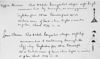
On the day after Endurance's departure, the stipendiary magistrate, Edward Binnie, reported on the expedition's visit to the colonial secretary in Stanley, Falkland Islands. He mentioned that meridian transit beacons had been erected and attached a copy of a report written by Hubert Hudson, navigating officer of Endurance, and countersigned by Shackleton (Binnie Reference Binnie1914). Hudson's report gives details of the calculations of the beacons' position and alignment from solar sightings and describes their construction, complete with diagrams (Fig. 1).
Part of the report on the meridian transit beacons by Hubert Hudson (Courtesy Scott Polar Research Institute).

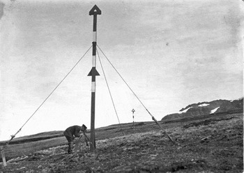
Hudson was assisted by Reginald James, the expedition physicist who was expert at using a theodolite for celestial observations. James (Reference James1916) wrote that the work took one week because they were hampered by snow and wind and, with Hudson and Frank Worsley, he built a shelter of sods for protection. This was described as ‘a peat shelter not unlike a shooting butt’ by James Wordie (Wordie Reference Wordie1916: 73). Both men used theodolites to take sun shots and a photograph taken by Frank Hurley of the completed beacons, that survived in Frank Worsley's photograph album (Worsley undated), shows Hudson in naval uniform, observing with a theodolite at the base of the lower post (Fig. 2). James also determined the magnetic variation at the site (Wordie Reference Wordie1916: 73).
Photo of Hubert Hudson at the meridian transit beacons by Frank Hurley, preserved in Frank Worsley's photograph album. On the reverse is written ‘Meridian posts erected at Cumberland Bay, Sth Georgia’ and initialled ‘RWJ’ [Reginald W. James] (Courtesy Scott Polar Research Institute).

The beacons consisted of two tall wooden posts located above a low cliff, about 70 ft [21 m] above sea level, on the opposite side of the entrance to King Edward Cove from the tip of King Edward Point. The posts were 15 ft [4.6 m] and 23 ft [7 m] high, painted with red and white bands and set 179 ft [54.6 m] apart. The lower, northern, beacon was supported by three guys and a single buttress, and the upper, southern, beacon was supported by at least two buttresses. Both were surmounted by open iron triangles and the lower beacon had a second triangle at the midpoint.
Subsequent history
Little is known about the use of the beacons. When Shackleton and other members of the Endurance expedition returned to Grytviken aboard Quest in 1922, they learned that the beacons were being used regularly by the whalers (Wild Reference Wild1923: 61).
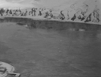
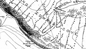
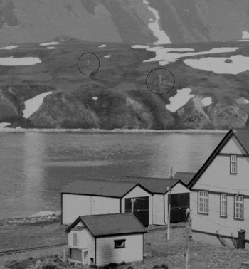
The beacons can be seen in photographs taken in the mid–1920s by Binnie, and Discovery investigations scientist, Francis Fraser (Fig. 3). They are marked on a hydrographic chart of King Edward Cove (Fig. 4) prepared by H.M.S. Dartmouth in 1920. In a memoir accompanying the chart, the surveyor, Lieutenant Commander W.G. Benn R.N., wrote that
Two beacons have been erected on the high ground on the south side of the cove about 70 ft [21.3 m] above sea level. The line of the beacons is north and south (true) and they were placed for the convenience of trawlers (sic) wishing to adjust their compasses. The beacons are about 10 feet [3 m] high; painted red and white with triangular topmarks. They are sometimes difficult to pick up when the snow is not on the ground (Benn Reference Benn1920).
Looking down on King Edward Cove in 1926. The beacons (ringed) on the far side of the cove stand out against the snow.

Part of the chart of King Edward Cove drawn by Lieut. Commander W.G. Benn R.N. in 1920. The meridian transit beacons are located at the bottom. (Courtesy Scott Polar Research Institute).

Replacement beacons
An extract of a letter in the Falkland Islands government archives from the commanding officer of R.R.S. Discovery II, dated 14 May 1934, describes meridian transit beacons, 90 yards [82 m] apart, painted with red and white bands. The northern beacon bore a triangular topmark and the southern a square topmark. They were placed ‘near the former position of the old marks (which no longer exist)’. This demonstrates that the beacons erected by Endurance had been replaced sometime between 1922 and 1934 (Fig. 5). It is not clear whether they had been replaced by the crew of Discovery II.
A photograph in the collection of the British Graham Land Expedition, which visited Grytviken in April 1937, shows the new beacons (ringed) (Courtesy Scott Polar Research Institute).

The Antarctic Pilot second edition (1948: 114) records two ‘deviation beacons’, the northern surmounted by a triangle, point up, and the southern by a square. The beacons are not mentioned in the 1961 and subsequent editions. However, they are shown in a chart drawn from a survey made in February to April 1958 by Lt. M.J. Stumbles R.N. of H.M.S. Protector (Stumbles Reference Stumbles1958).
George Brown (G. Brown, personal communication, 2010) who was stationed at King Edward Point from 1954 to 1957, recalls the beacons. The most recent records I have found of the standing beacons are in a photograph taken by R.W. Vaughan in 1962 showing the northern beacon and a photograph taken by Tony Keville in 1973 showing the southern beacon lying on the ground.
The remains of the beacons
In 2001, when visiting Grytviken on m/s Explorer, the author found three very rotten posts, with the remains of steel wire guys and topmarks, lying on the ground approximately in the position indicated by the early photographs and charts. Two posts (labelled ‘middle’ and ‘lower’) superficially fitted Hudson's description. The third (‘upper’) lay farther up the hillside. At the time I was unaware that the original beacons had been replaced and was puzzled that the posts and their fittings did not tally with Hudson's description. In December 2008, while staying at King Edward Point, I was able to investigate the posts in detail.
By comparing the positions of the beacons in the photographs with the remains lying on the ground, it is possible to see that my ‘middle’ and ‘upper’ posts correspond to the replacement beacons recorded by the commanding officer of Discovery II. GPS positions taken with an accuracy of less than 15 cm radius show that these posts are aligned within one second of longitude arc of a true meridian (M. Macfarlane, personal communication, 2009).
The third post, the author's ‘lower’ post, is approximately in the position of Hudson's lower beacon. When the image of Fig. 5 is enlarged, this post can be seen on the ground, its position corresponding well with the lower beacon in Fig. 3. It is the same length (22.5 ft compared with 23 ft) as Hudson's lower beacon and has three steel wire guys fixed at the right height (calculated from Fig. 2). There are no signs of the two triangular iron marks but they could have been removed and used on the new marks. A rebate at the top of the post indicates where the topmark could have been fixed. It is possible, therefore, that this is Hudson's lower beacon.
Conclusion
There is apparently no written record of the meridian transit beacons in King Edward Cove being used for swinging compasses after Quest's visit in 1922, although their use may have been recorded in the logs of whalecatchers. Carl Thor Thorsen (C.T. Thorsen, personal communication, 2010), who worked at Grytviken whaling station from 1948 to 1967, states that the beacons were not in use during this period and that sextants were used for adjusting compasses.
The author had hoped that the posts he found would prove to be the original beacons erected in 1914 and, as such, they would be the only known relics on South Georgia of Ernest Shackleton's expedition, for which South Georgia is famous. It is possible that the ‘bottom’ post is one of the original beacons. The posts are, nevertheless, an interesting relic of the aids to navigation established during the whaling period. Their importance to the whalers at one time is shown by the replacement of the original pair. The rotten remains deserve to be added to the catalogue of historic sites maintained by the Government of South Georgia and South Sandwich Islands.
Acknowledgements
I would like to thank the Government of South Georgia and the South Sandwich Islands for giving me permission to stay at King Edward Point, South Georgia, and Pat and Sarah Lurcock for their generous hospitality and detailed assistance. Geraldine Massyn and Gillian Walker helped me find the remains of the beacons and my wife Jackie helped investigate them. Malcolm Macfarlane took GPS readings of their positions. Mr Peter Wordie kindly gave me a copy of his father's diary. Abercrombie & Kent and Polar Star Expeditions assisted with passages to and from South Georgia and the South Georgia Heritage Trust generously assisted with travel expenses.