

From as early as 1100 BC, burnt lime (cal in Spanish) has been one of the most important materials in the daily lives of the Maya. Nevertheless, considering the importance of lime for construction, hygienic, and dietary purposes, there is surprisingly little information regarding lime production prior to the sixteenth century. This relative absence of information is largely due to the ephemeral nature of lime and the lack of lime production locations identified in the archaeological record (Morris et al. Reference Morris, Charlot and Morris1931:220–225; Schreiner Reference Schreiner2002:2–5; Seligson et al. Reference Seligson, Negrón, Ciau, Bey and Rubenstein2017b; Wernecke Reference Wernecke2005:169, Reference Wernecke2008:205). Aside from the identification of a few aboveground features (MacKinnon and May Reference MacKinnon and May1990; Russell and Dahlin Reference Russell and Dahlin2007), prehispanic lime production studies have centered on the identification of permanent structures like pit-kilns. Even when potential pit-kilns are identified, however, the evidence for lime production often remains somewhat ambiguous (Abrams Reference Abrams, Sanders and Mastache1996; Abrams and Freter Reference Abrams and Freter1996; Wernecke Reference Wernecke2008). The relative dearth of positive identifications reflects not only the difficulty of detecting these locations but suggests that archaeologists may be overlooking potential lime production features. This article presents a comprehensive approach for identifying annular structures documented in and around the site of Kiuic in the Puuc region of Yucatán as prehispanic lime pit-kilns. Although this particular type of annular structure may be distinctive to the Puuc region, the methods described here provide a model for identifying lime production features elsewhere in the Maya area and Mesoamerica more broadly.
Burnt lime is produced by heating calcium carbonate (limestone or shell in the Maya area) to at least 800°C for an extended period of time. This chemically changes the stone to a caustic material called quicklime, or calcium oxide. The quicklime is then left to absorb water naturally, or small quantities of water are added manually, which causes the quicklime to break down into the fine, white powder known as burnt lime, or calcium hydroxide. Burnt lime can then be mixed with aggregates and more water to form a cement-like slurry that dries and hardens once again into calcium carbonate.
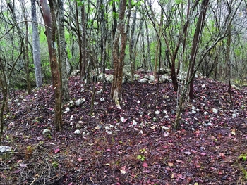
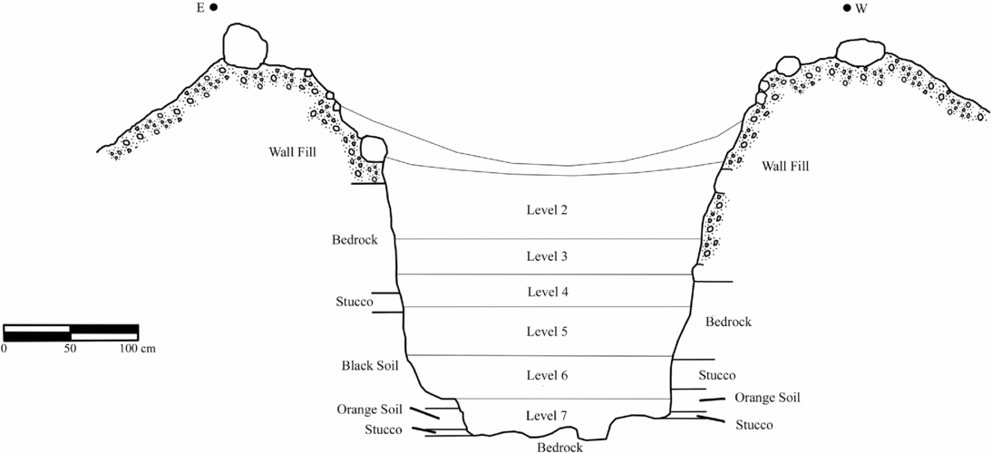
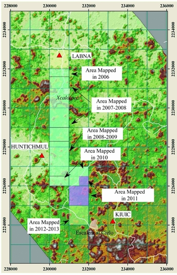
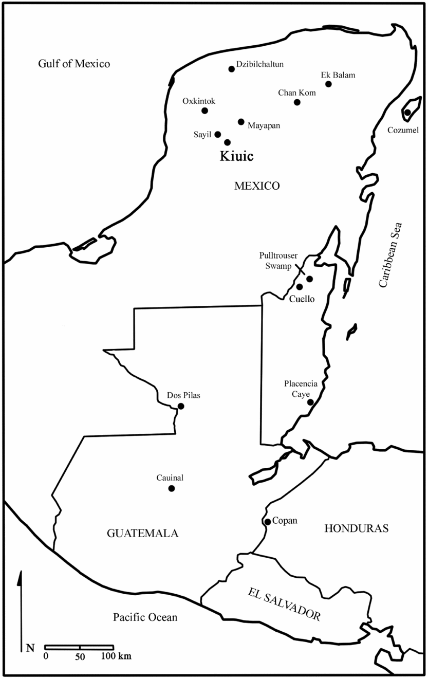
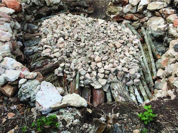
The Kiuic annular structures are low mounds capped by a single or double ring of boulders that surround a central depression (Figures 1 and 2; Seligson Reference Seligson2016; Seligson et al. Reference Seligson, Negrón, Ciau and Bey2017a, Reference Seligson, Negrón, Ciau, Bey and Rubenstein2017b). Over 140 annular pit-kilns were identified as part of a 9 km2 intersite survey between the Puuc sites of Labná and Kiuic directed by the second and third authors (Figure 3; Gallareta Negrón et al. Reference Gallareta Negrón, Bey and Ringle2014). Annular pit-kilns similar to those identified in and around Kiuic have thus far only been identified at sites in the Puuc region of the northern lowlands, including Oxkintok (n = 13) (Ortíz Ruíz Reference Ortíz Ruíz2014), Sayil (n = 24) (Sabloff and Tourtellot Reference Sabloff and Tourtellot1991), Labna, Huntichmul (Gallareta Negrón et al. Reference Gallareta Negrón, Bey and Ringle2014), and along the Sierrita de Ticul escarpment that delineates the northeastern edge of the Puuc region. Two possible exceptions are two double-ringed pit-kilns identified respectively by Fauvet-Berthelot (Reference Fauvet-Berthelot1980) at Cauinal, Guatemala, and Nancy Ettlinger (Reference Ettlinger, Harrison and Turner1983) at Pulltrouser Swamp, Belize (Figure 4). These are most similar to the variety of annular structures identified at Oxkintok. Future research may result in the identification of more prehispanic annular pit-kilns elsewhere in the broader Maya region, but at this time, annular pit-kilns of this particular form and depth appear to be limited to the Puuc region. The large quantity of lime pit-kilns identified in the Puuc also appears to be distinct to the region, which may have reflected the need for increased lime production to supply expansive Terminal Classic period construction programs.
A standard annular structure as viewed in the archaeological record with only surface materials cleared.

Cut view of Annular Structure 8 showing the typical profile of an annular structure.

The Labná-Kiuic intersite survey area (Gallareta Negrón et al. Reference Gallareta Negrón, Bey and Ringle2014).

The Maya area highlighting archaeological sites where prehispanic lime kilns have been identified.

Although the annular pit-kiln technology may have been largely limited to the Puuc region, lime production features have been identified elsewhere in the Maya area, albeit infrequently (Seligson Reference Seligson2016; Seligson et al. Reference Seligson, Negrón, Ciau and Bey2017a). Archaeologists have documented bowl-shaped pit-kilns with rounded bottoms at Copan, Honduras (Viel Reference Viel and Baudez1983; Whittington Reference Whittington1991), and at Dos Pilas, Guatemala (Johnston et al. Reference Johnston, Inomata, Palka, Demarest and Houston1989). Abrams and Freter (Reference Abrams and Freter1996) documented a partially enclosed pit-kiln at Copan that was unlike the Puuc annular pit-kilns (see also Abrams Reference Abrams, Sanders and Mastache1996). Additional identifications of potential lime pit-kilns were made by Redfield and Villa Rojas (Reference Redfield and Rojas1934) at Chan Kom, by Freidel and Sabloff (Reference Freidel and Sabloff1984:35) on Cozumel, and by Barrera Rubio (Reference Barrera Rubio2013) in the northeast of the Yucatán Peninsula. A similar type of open-air firing feature to the ones identified by Russell and Dahlin (Reference Russell and Dahlin2007) was discovered by MacKinnon and May (Reference MacKinnon and May1990) at Placencia Caye in Belize, most likely to produce lime from marine shells. Craig Hanson (Reference Hanson2008:854) identified four prehispanic pit-kilns at Ek Balam that may have been used for lime production. These were built into residential platforms instead of excavated directly into the bedrock like the Puuc pit-kilns.
Turning to Mesoamerica more broadly, potential lime production features have been identified at Chalcatzingo in Morelos (Grove and Guillen Reference Grove, Guillén and Grove1987; Martín Arana Reference Martín Arana and Grove1987:392–393), in the Tepeaca municipality of Puebla (Castanzo Reference Castanzo2004; Castanzo and Anderson Reference Castanzo and Anderson2004), and in the Tehuacan Valley (Sisson Reference Sisson1973:98–100). Lime has continued to be an important material for everyday life in the Maya area up through the historic period and into the present. Ethnographic and historical archaeological studies of lime production suggest that open-air burns and Old World-style updraft kilns have been the standard production methods in the Maya area since the sixteenth century (Hanson Reference Hanson2008; Schreiner Reference Schreiner2002). Considering the amount of lime that would have been used by the Maya from at least 1100 BC onward (Hammond and Gerhardt Reference Hammond and Gerhardt1990), the scarcity of documented prehispanic lime production features is striking.
Previous studies of annular structures at Oxkintok by Soledad Ortíz Ruíz (Reference Ortíz Ruíz2014) and colleagues and at Sayíl (Dunning Reference Dunning, Sabloff and Tourtellot1991:25) have indicated that they likely functioned as pit-kilns for producing burnt lime. The current investigation combines multiple lines of investigation to test the hypothesis that the annular structures are in fact lime pit-kilns. Data are drawn from 1) the systematic excavation of nine annular structures, 2) archaeometric analyses including inductively coupled plasma-optical emission spectrometry (ICP-OES) and stable oxygen and carbon isotope analyses, 3) the experimental construction and firing of an annular structure, and 4) ethnographic research combined with the spatial and contextual analyses of 53 annular structures. Combining these multiple lines of evidence provides a comprehensive approach to identify prehispanic lime production features. The identification of pit-kilns has implications for understanding prehispanic Maya environmental resource management and decentralized craft production organization, topics that are discussed in great detail elsewhere (Abrams and Rue Reference Abrams and Rue1988; Hansen et al. Reference Hansen, Bozarth, Jacob, Wahl and Schreiner2002; Morris et al. Reference Morris, Charlot and Morris1931:220–225; Russell and Dahlin Reference Russell and Dahlin2007:407; Schreiner Reference Schreiner2002:2–5; Seligson et al. Reference Seligson, Negrón, Ciau and Bey2017a; Wernecke Reference Wernecke2005:169, Reference Wernecke2008:205).
The Kiuic Annular Structure Case Study
Archaeological Setting
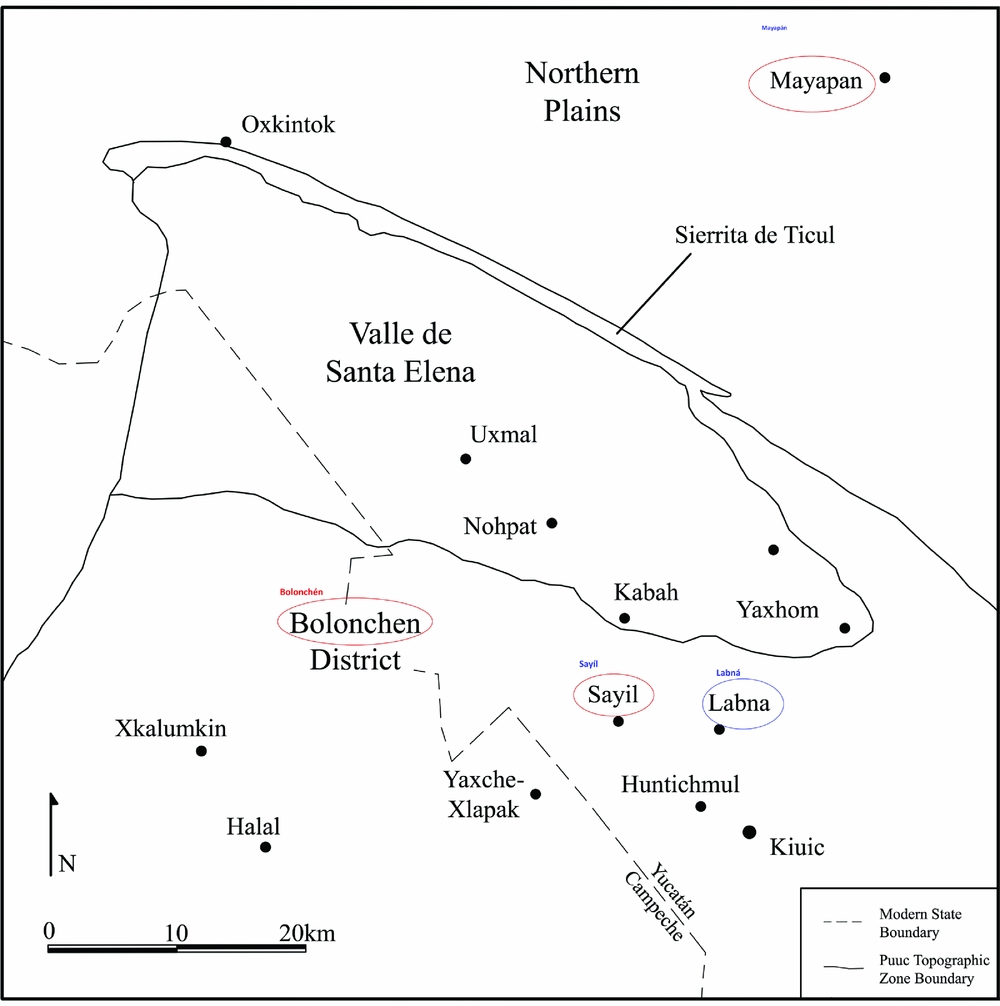
The Puuc region is characterized by a distinctive hilly topography and an archaeological subculture with a high frequency of masonry architecture (Figure 5; Gallareta Negrón et al. Reference Gallareta Negrón, Bey and Ringle2014). The Puuc is bordered to the northeast by the Sierrita de Ticul escarpment that runs southeast from Oxkintok. To the west of the Sierrita in the northern zone of the Puuc lies the triangular, relatively flat stretch of the Valle de Santa Elena. Large archaeological sites including Uxmal, Nohpat, Kabah, and Yaxhom that are located in the valley most likely controlled access to the distinctively deep and fertile soils that would have drawn ancient settlers to the region (Barrera Rubio Reference Barrera Rubio1987; Simms et al. Reference Simms, Parker, Bey and Negrón2012). To the south and southeast of the Valle de Santa Elena is the Bolonchén District where Kiuic and other ancient sites such as Labna and Sayil are located.
The northern Puuc region showing the location of Kiuic (Seligson et al. Reference Seligson, Negrón, Ciau and Bey2017a).
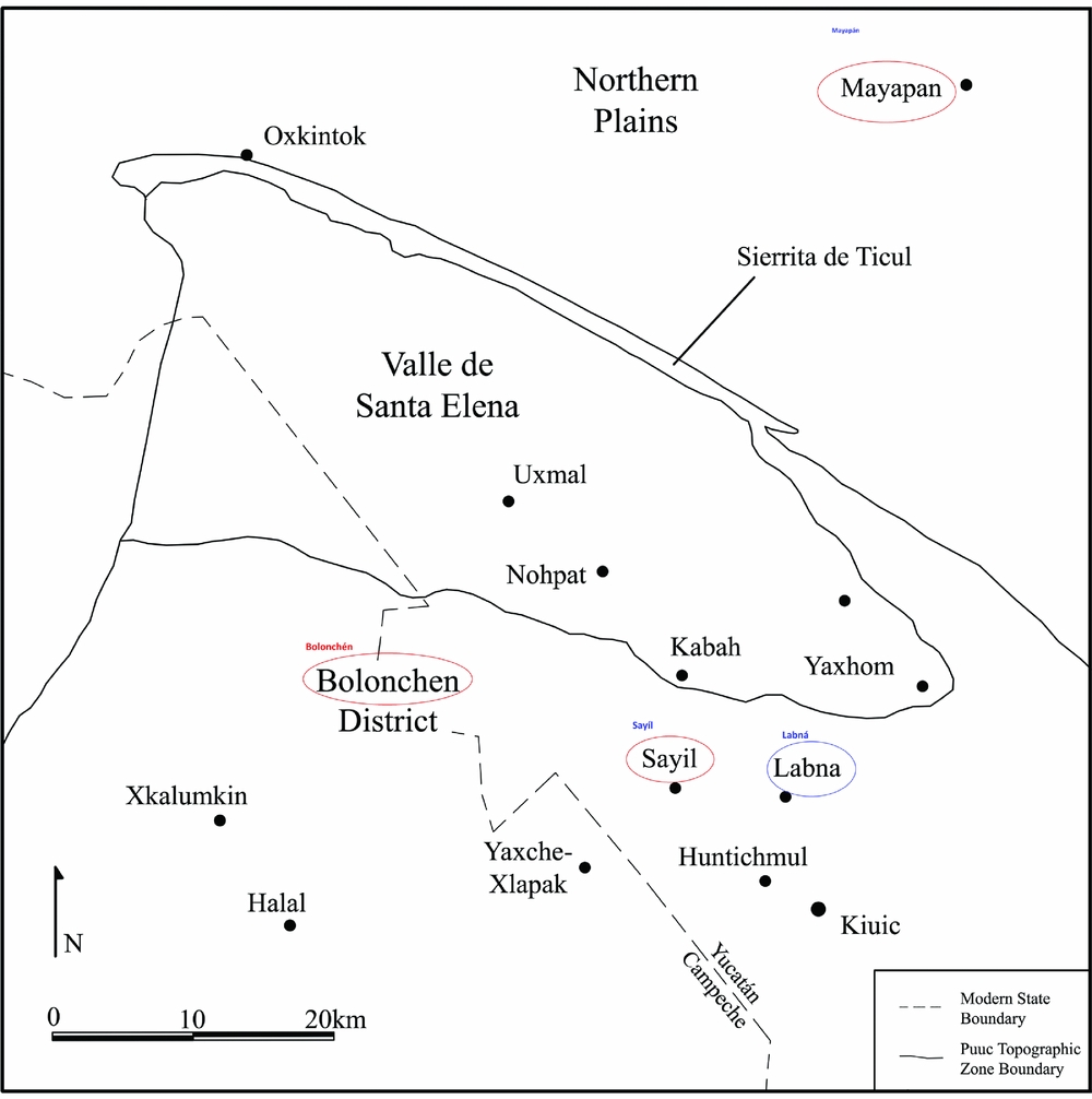
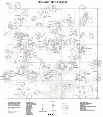
The mid-level, Range III (Garza Tarazona de Gonzalez and Kurjack Reference Garza Tarazona de Gonzalez and Kurjack1980) site of Kiuic is located within a circular valley surrounded by a ring of low hills, many of which possess archaeological complexes on their apices (Simms et al. Reference Simms, Parker, Bey and Negrón2012). The Bolonchén Regional Archaeological Project (BRAP) directed by Tomás Gallareta Negrón, George J. Bey III, and William Ringle has overseen excavations and archaeological surveys in and around Kiuic since the year 2000 (Gallareta Negrón et al. Reference Gallareta Negrón, Bey and Ringle2014). Excavations in the Dzunun plaza of the Kiuic site center have uncovered evidence of occupation dating back to circa 800 BC and continuing through to a peak era of construction activity between AD 650 and 950 (Figure 6; Gallareta Negrón et al. Reference Gallareta Negrón, Bey and Ringle2014).
The Kiuic site center by William Ringle and colleagues (Gallareta Negrón et al. Reference Gallareta Negrón, Bey and Ringle2014).

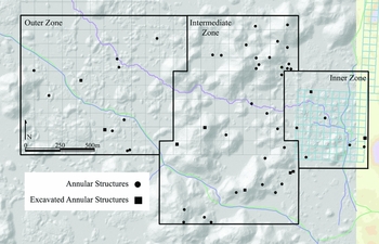
As part of the larger BRAP program, Gallareta Negrón and colleagues (Reference Gallareta Negrón, Bey and Ringle2014) conducted an intensive 9-plus km2 ground survey between the sites of Labna and Kiuic between 2001 and 2014. During the survey, they identified all human-made and -modified features in the survey area, including more than 140 annular structures. This study focuses on the part of the survey area that would have likely fallen within the bounds of the Terminal Classic period Kiuic polity (ca. AD 700–950) and includes a total of 53 annular structures (Figure 7).
The distribution of annular structures with regard to the inner, intermediate, and outer zones of the Kiuic polity (Seligson et al. Reference Seligson, Negrón, Ciau and Bey2017a).

Methods
Several quantitative and qualitative research methods were used to determine the function(s) of the Kiuic annular structures. These included 1) a systematic excavation program; 2) archaeometric analyses; 3) experimental archaeology; 4) the incorporation of ethnographic data; and 5) spatial and contextual analyses. The study area was divided into inner, intermediate, and outer zones based on distance from the site core, topography, and frequency of residential architecture. A random sample of nine annular structures was chosen for excavation from within each of these zones with the breakdown based on the proportional total amount of annular structures located in each zone. These nine structures included those located within residential compounds, outside compounds, and others that were fairly isolated from other archaeological features (Seligson Reference Seligson2016).
Several categories of material were recovered from the excavations, including partially burnt pieces of limestone, sascab (a soft type of marl, or unconsolidated limestone, that occurs naturally in pockets below the harder caprock limestone), reconstituted calcium carbonate, ceramic sherds, soil, and charcoal. These materials provided evidence for burning episodes within the structures as well as the types of materials that were burnt. The systematic excavation of the annular structures also allowed for a better understanding of their original forms and provided insights into their construction histories.
The second part of the testing program included stable carbon and oxygen isotope analyses, ICP-OES, and radiocarbon dating. The carbon and oxygen isotope tests determined whether the samples of sascab recovered from within the annular structures represented naturally occurring sascab or reconstituted calcium carbonate. Carbon isotope analyses measured the ratio of 13C to 12C isotopes (or δ13C) in the sascab/plaster samples. The δ13C level of naturally occurring limestone is generally close to 0 while the δ13C level of lime plasters is significantly lower (Létolle et al. Reference Létolle, Gégout, Rafai and Revertegat1992; Murakami et al. Reference Murakami, Hodgins and Simon2013). This is due to the fact that natural limestone was formed under ancient oceans and absorbed CO2 isotopes from water. Reconstituted calcium carbonate has gone through a process in which it loses its original CO2 isotopes and absorbs new CO2 isotopes from the air and/or rainwater (Létolle et al. Reference Létolle, Gégout, Rafai and Revertegat1992). Depending on the degree of decalcination or decarboxylation of the original limestone, lime plasters may have a δ13C level as low as –21. A similar phenomenon is observed in the ratio between 16O and 18O (or δ18O), where lower levels reflect greater amounts of decarboxylation and then recarbonation of the materials (Létolle et al. Reference Létolle, Gégout, Rafai and Revertegat1992; Murakami et al. Reference Murakami, Hodgins and Simon2013). Thus, if it was found that the limestone and sascab samples had low δ13C and δ18O levels, it would indicate that the materials had been reconstituted as calcium carbonate.
ICP-OES analyses were used to analyze limestone, sascab, and soil samples to detect the presence of wood ash in the kilns and determine whether the sascab/plaster samples had high or low levels of magnesium, which would provide another way of distinguishing between the natural and the reconstituted material. Naturally occurring sascab has been demonstrated to have higher levels of magnesium than the overlying bedrock layers from which burnt lime is produced due to downward percolation of magnesium atoms with rainwater (Villaseñor Reference Villaseñor2010:25). Charcoal and/or botanical samples recovered from within the annular structures were used to identify the genera of trees used as fuel within the kilns, as well as to date the use of the structures through radiocarbon dating.
A third test of the function(s) of the annular structures was the experimental construction and firing of an annular pit-kiln modeled on the prehispanic structures. The purpose of this experiment was to test the practicality of a partially enclosed pit-kiln for producing burnt lime. The physical evidence resulting from the experiment was compared with the physical evidence discovered in and around the prehispanic annular structures.
The final methods to determine the function(s) of the annular structures combined spatial and contextual analyses with ethnographic data concerning the uses of different grades of limestone. Interviews with local informants provided information regarding different grades of limestone and knowledge of those types most conducive to lime production. Correlations between the locations of annular structures and sakel bach tunich—the type of limestone most suitable for making burnt lime—provided an additional line of evidence supporting the functions of these structures as lime pit-kilns.
Results
Carbon and Oxygen Isotope and ICP-OES Analyses
Annular Structure 1
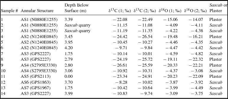
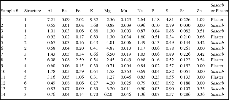
Sascab/plaster levels were encountered in eight of the nine annular structures, and samples were recovered from seven of the structures. A sample recovered from the interior floor of Annular Structure 1 (Sample 1) possessed isotopic levels of –22.08, –22.49 δ13C and –15.06, –14.07 δ18O), which are consistent with levels for reconstituted calcium carbonate (Table 1). ICP-OES analyses showed that Sample 1 possessed higher levels of phosphorous (1.18 ppm) compared with Samples 2 and 3, which were recovered from nearby sascab quarries (0.10 and 0.04, respectively; Table 2). The subterranean sascab layer from the nearby quarry extended all the way through the central depression of Annular Structure 1. Thus, the quarry samples provide a baseline for the amount of phosphorous that occurs naturally in the limestone around the structure. The higher level of phosphorous in the reconstituted calcium carbonate sample from the structure reflects the mixing of wood ash with the sample.
The δ13C and δ18O Levels of the Different Sascab/Plaster Samples.

Note: δ13C and δ18C values are close to 0 per mil for natural limestone and −21 per mil for reconstituted carbonate
The ICP-OES Results for the Sascab/Plaster Samples.

Note: All data reported as ppm.
Annular Structure 2
Samples 4, 5, and 6 were recovered from different depths within the central depression of Annular Structure 2. The isotopic data indicate that Sample 4 (–24.42, −26.54 δ13C and –19.50, –16.20 δ18O) represents reconstituted lime, while Sample 5 (–10.45, −10.27 δ13C and –4.46, –4.35 δ18O) and Sample 6 (–9.70, –9.84 δ13C and –4.47, –4.42 δ18O) are most likely naturally occurring sascab. Sample 5 was recovered from a layer that exhibited visual evidence of burning, but the sample itself exhibits isotopic signatures of naturally occurring sascab. This suggests that roughly 3.95 m below the surface of the ring represents the lowest level of burning in the kiln. This in turn suggests that the approximately 50 cm thick layer of material between the points from where Sample 4 and Sample 5 were recovered is made up of reconstituted calcium carbonate.
The ICP-OES analyses show that Sample 4 (0.51 ppm) has a higher level of phosphorous than Sample 5 (0.13 ppm) and Sample 6 (0.06 ppm). The higher level of phosphorous reflects the mixing of wood ash with Sample 4. Another discrepancy between the uppermost sample and the two lower samples is the level of magnesium: Sample 4 (1.30 ppm), Sample 5 (4.01 ppm), and Sample 6 (4.87 ppm). This supports the interpretation that the lower layer is sascab and the upper layer material is not. Sascab has been shown to have higher magnesium levels than overlying limestone (or in this case burnt lime) due to the migration of magnesium atoms downward with rainwater (Villaseñor Reference Villaseñor2010:25).
Annular Structure 3
Samples 7, 8, and 14 were recovered from the interior of Annular Structure 3. The isotopic data indicate that Sample 8 (–24.19, –25.72 δ13C and –19.11, −22.30 δ18O) represents reconstituted lime, while Sample 7 (–10.14, –10.01 δ13C and –4.59, –4.83 δ18O) and Sample 14 (–10.83, –9.74 δ13C and –3.09, –3.75 δ18O) represent naturally occurring sascab. Samples 7 and 14 were much more similar to each other than either was to Sample 8 in terms of elemental composition as well. The ICP-OES analysis showed that Sample 8 (0.16 ppm) exhibited slightly higher levels of phosphorus than Sample 7 (0.06 ppm) and Sample 14 (0.07 ppm). Also, differences in magnesium levels support the interpretation that Sample 8 is reconstituted calcium carbonate while Samples 7 and 14 are naturally occurring sascab.
Annular Structure 4
Samples 9 and 10 were recovered from Annular Structure 4. The isotopic data indicate that Sample 9 (–26.61, −25.60 δ13C and –20.33, –22.21 δ18O) represents reconstituted lime while Sample 10 (–10.90, −10.30 δ13C and –4.37, –3.08 δ18O) represents naturally occurring sascab. This is consistent with the pattern identified in the other annular structures, where a layer of reconstituted calcium carbonate overlays a layer of natural sascab at the base of the interior depressions of the structures.
Annular Structure 5
Sample 11 was recovered from the base of the interior of Annular Structure 5. The isotopic data indicate that the material recovered is reconstituted calcium carbonate (–23.34, –24.91 δ13C and –20.23, −22.10 δ18O). This is somewhat peculiar in that Annular Structure 5 is the only one with a central depression that does not enter. This suggests that the kiln may have been used for only a limited number of burning episodes or atop an especially hard patch of surface bedrock.
Annular Structures 6 and 7
Samples 12 and 13 were collected from Annular Structures 6 and 7, respectively. The isotopic data for Sample 12 indicate that the material was naturally occurring sascab (–8.28, –10.02 δ13C and –3.90, –3.92 δ18O). The isotopic data from Sample 13 likewise indicate that the material encountered was indeed natural sascab (–10.40/–10.64 δ13C and –3.99/–4.49 δ18O). Both samples have relatively high levels of magnesium (Sample 12: 4.20 ppm; Sample 13: 3.20 ppm), which further suggests that they represent sascab instead of burnt lime.
Radiocarbon Data and Charcoal Species Identification
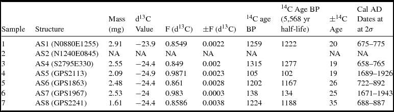
At least one charcoal sample was recovered from six of the nine annular structures, and seven were selected to be sent for AMS radiocarbon dating at the University of Arizona AMS laboratory. Two of the samples returned erroneous dates from the nineteenth century and one could not be dated, but the four charcoal samples that returned prehispanic dates were firmly dated to the Late and Terminal Classic periods (Table 3). These include samples from Annular Structure 1 (1222 ± 20 BP, 675–775 cal AD at 2σ), Annular Structure 4 (1276 ± 19 BP, 658–765 cal AD at 2σ), Annular Structure 6 (1167 ± 26 BP, 766–892 cal AD at 2σ), and Annular Structure 8 (1188 ± 35 BP, 688–887 cal AD at 2σ; Seligson et al. Reference Seligson, Negrón, Ciau and Bey2017a:14–16). The measurements were background subtracted and isotope fractionation corrected. The calibrations were calculated using IntCal13 and OxCal4.2.4 software.
Radiocarbon Data for the Seven Charcoal Samples.

In addition to using the recovered charcoal for dating the construction and use of the structures, some of the pieces were well enough preserved to allow for their taxonomic identification. The identifiable pieces of charcoal included dicotyledonous angiosperms (or hardwood species). Two tentative species identifications were made for Piscidia piscipula (or ja'abin in Yucatec Maya) and a Lonchocarpus species like the balche tree, which were both used in the experimental burning.
Spatial Analyses
Of the 53 annular structures in the study area, seven are located in the Kiuic inner zone (13%), 35 are located in the hilly intermediate zone (66%), and 11 are located in the outer zone (21%) beyond the ring of hills. Across all of the zones, the most consistent contextual correlations for the annular structures are that they are located near outcrops of SBT limestone (the type most desirable for making lime), and they are situated on elevated or sloping terrain. Sakel bach tunich outcrops are dispersed throughout the region as part of the broader limestone bedrock matrix, but they are not dispersed uniformly. Unfortunately, microregional geologic distribution charts are unavailable. Nine of 11 (82%) outer zone annular structures are located within 25 m of an SBT outcrop, and all 11 are located within 50 m of an SBT outcrop. A total of 27 out of 35 intermediate zone annular structures (77%) and 6 of 7 inner zone annular structures (86%) are also located within 25 m of an SBT outcrop.
Ceramic Analyses
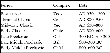
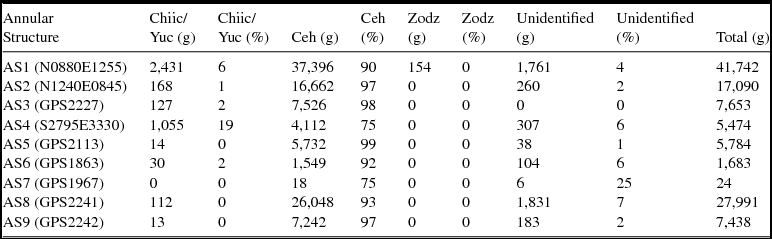
The majority of the sherds excavated were part of the fill used in the walls of the annular structures. The low quantity of sherds that exhibited evidence of burning suggests that they were packed within the walls of the kiln and not directly exposed to the fire as one would expect if they had been used to help pack the wood fuel. The identification of the sherds as belonging to certain ceramic complexes provided additional chronological information about the construction and use of the annular structures (Tables 4 and 5). Overall, 93% of the ceramics by weight recovered during the excavations of the annular structures dated to the Terminal Classic period, with 3% dating to the Middle or Late Classic period (Kohut Reference Kohut2015). Four percent of the ceramics were unidentifiable due to erosion, wear, or burning. The ceramic data thus clearly point to the annular structures being constructed and used during the Late to Terminal Classic period transition, which complement the AMS radiocarbon data. These construction and use dates provide indirect support for the hypothesis that the annular pit-kiln technology was developed to produce lime during the demographic and construction boom of the Terminal Classic period (Gallareta Negrón et al. Reference Gallareta Negrón, Bey and Ringle2014; Gunn Reference Gunn2015).
Ceramic Chronology for Kiuic and the Eastern Puuc Region.

Source: Adapted from Kohut Reference Kohut2015.
Ceramic Sherd Weight Totals and Percentages for the Different Ceramic Complexes Recovered from the Nine Excavated Annular Structures.

Source: Adapted from Kohut Reference Kohut2015.
Experimental Kiln Firings
In February 2015, Seligson oversaw the construction of an experimental annular lime kiln modeled on the prehispanic annular structures at the Kaxil Kiuic Research and Learning Center (Figure 8). Freshly cut green wood was gathered for the firing process, which allowed for a slower burn at higher temperatures. Unfortunately, the first experimental burn was hindered by an unexpected dry season rainfall episode, which skewed the results. Only approximately half of the pieces of raw limestone were calcined at the end of the 20-plus-hour firing episode. Using 3.87 m3 of wood fuel, only 0.76 m3 of burnt lime was produced. This resulted in a final ratio of wood fuel to lime produced of 5.09:1. The second experimental burn was conducted in June 2015 with only minimal interference from precipitation. A volume of 2.85 m3 of wood fuel was used for the second experiment. This time the vast majority of the limestone calcined and was hydrated into lime powder. A total of 0.72 m3 of burnt lime was produced during this second experiment, resulting in a fuel-to-product ratio of 3.95:1 (Seligson et al. Reference Seligson, Negrón, Ciau and Bey2017a).
Small pieces of limestone (chich) placed atop the wood fuel ready to be fired (Seligson et al. Reference Seligson, Negrón, Ciau and Bey2017a).

The firing experiments demonstrated that the annular pit-kilns could be used to transform limestone into lime powder efficiently. Though the experimental kiln was not as deep as the majority of the excavated archaeological annular structures, it did provide a partially subterranean and completely encircled space for burning limestone. The burning signatures left on the interior walls of the experimental structure were similar to the signatures found on the archaeological structures. The burning episodes also resulted in a substantial amount of wood ash at the bottom of the kiln, which was similar to the large quantity uncovered in several of the archaeological structures. The extended burn loosened approximately 10–15 cm of the underlying bedrock, which could be easily removed before a subsequent burn. This helps to explain why some of the archaeological annular structures reached such great depths. Their final forms were likely the result of numerous successive burns in the same location. Finally, the experimental burns resulted in the generation of a significant quantity of burnt or partially burnt, but not completely calcined, fist-size pieces of limestone (chich in Yucatec Maya). The burnt and partially burnt chich resembled similar pieces of chich identified in and around the majority of the archaeological annular structures (Seligson et al. Reference Seligson, Negrón, Ciau and Bey2017a).
Ethnographic Data and Spatial Analyses
Limestone is by far the most ubiquitous type of stone in Yucatán. Although it is impossible to project modern knowledge of limestone variation directly back to the prehispanic inhabitants of the Puuc, exploring the folk names and use for different types of limestone provide the closest available analogue. Ethnohistoric and modern ethnographic accounts reference at least four recognizable types of limestone. The preferred type for making lime is a slightly porous though not too soft type with a yellowish hue referred to as sakel bach tunich (white bird's egg stone [translation by authors]). Stone workers in the town of Dzityá located northwest of Mérida call it by this term (Peraza López Reference Peraza López and Vargas1993), as do potters in the town of Ticul on the edge of the Puuc region (Arnold Reference Arnold2008:285) and our own collaborators in the Puuc towns of Yaxhachen and Kobenhaltun. In the Yaxcabá ejido of central Yucatán, this same type is called hel bach (Levy Tacher and Hernández Xolocotzi Reference Levy Tacher, Xolocotzi, Xolocotzi, Baltazar and Tacher1995:264), and in other areas it is referred to as sak ebach or ebach (Schreiner Reference Schreiner, Laporte, de Suasnávar and Arroyo2001:358).
There are three other general types of limestone recognized in Yucatán that are not as desirable for lime production. These include the softer limestone marl referred to variously as sak tunich, sascab tunich, and sah kab tunich, which generally means “white stone” or “white earth stone” (translations by authors). A harder, less porous grade of limestone with a grayish hue is referred to as sak tok’, toc tunich, tok’ tunich, or taman tunich, meaning roughly “hard stone” (translation by authors). The final type, distinguished by its reddish or pinkish hue, is referred to by variations of the label chak tunich or “red stone” (translation by authors; Levy Tacher and Hernández Xolocotzi Reference Levy Tacher, Xolocotzi, Xolocotzi, Baltazar and Tacher1995:264; Peraza López Reference Peraza López and Vargas1993; Schreiner Reference Schreiner, Laporte, de Suasnávar and Arroyo2001:358). The Spanish-Yucatec Mayan Diccionario Maya Cordemex compiled from both ethnographic and ethnohistoric accounts dating back to the sixteenth century AD refers to limestone generally as sahkab and includes a reference to sahkab as “tierra con que se fabrica la cal” (Barrera Vásquez Reference Barrera Vásquez1980:708) or “earth from which burnt lime is manufactured” (translation by authors). Another entry does specify that tok’ tunich is “piedra dura, fuerte o pedernal” (Barrera Vásquez Reference Barrera Vásquez1980:805), or “rock that is hard, strong, or chert” (translation by authors). The dictionary does not include references to any variation of sakel bach tunich or chak tunich. The absence of these terms reflects the fact that the dictionary does not focus on limestone processing or lime production.
Our local collaborators, Don Gabriel Us and Don Evelio Uc, who both had previous experience with lime production, describe and identify the four general aforementioned types of limestone:
-
• sakel bach tunich: This type of limestone is particularly white in appearance and of a medium-hard composition, and it is the best type for making lime powder.
-
• tok’ tunich: This general type of limestone is grayer in appearance, harder in composition, and is not suitable for making lime powder.
-
• chak tunich: This type of limestone has a high iron content that gives it a reddish hue. It is generally unsuitable for making lime powder and, if used, results in a lime powder that has a pinkish hue.
-
• sah kab tunich: This is the softer, white limestone also known as sascab that is unsuitable for making lime powder.
The identifications demonstrate the familiarity of the collaborators with the nuances of lime production. These different types occur unevenly throughout the landscape, often blending together to form the bedrock matrix. There are, however, outcrops of limestone that are dominated by one type or another. A final approach for determining the function of the annular pit-kilns drew on the limestone identification expertise of the collaborators. Spatial analyses confirmed the correlation between annular structure locations and outcrops of sakel bach tunich.
Discussion: The Evidence for Annular Structures Functioning as Burnt-Lime Kilns
Physical Evidence
Evidence for Burning
The boulders that formed the interior surface rings of the nine excavated annular structures and an additional 20 of the surveyed structures exhibited a blackened appearance from exposure to fire. With the exception of Annular Structure 5, the central depressions of all of the excavated annular structures crossed through the surface layer of bedrock. The bedrock portions of the interior walls of all of these structures (as well as the surface bedrock floor of Annular Structure 5) exhibited the blackened coloring and friable texture of bedrock that had been repeatedly exposed to firing episodes (Seligson et al. Reference Seligson, Negrón, Ciau and Bey2017a). The discovery of charcoal or wood ash and burnt soil in the lowest layers of eight of the structures provides another direct line of evidence for burning episodes. Multiple burnt layers separated by thin layers of reconstituted calcium carbonate near the bottoms of seven of the structures represented the remains of multiple successive burning episodes.
The depth of the majority of the annular structures also indicates their repeated use for firing events. The pit-kiln experiment demonstrated that the 20-plus-hour burn loosened 10 to 15 cm of bedrock from the floor of the pit. This limestone, which was the same sakel bach tunich that dominated the outcrop into which the experimental kiln was built, was then easily removed and could be used for a subsequent burn. If this pattern was continued repeatedly, the depth of this experimental kiln would eventually reach levels comparable to the archaeological structures.
Burnt Chich
The high concentration of burnt or partially burnt chich around the annular structures suggests that the prehispanic Maya used them to burn limestone. The majority of the pieces of chich that are scattered around the structures belong to the sakel bach variety. In some cases, the partially burnt pieces of chich appear to have been randomly scattered after they did not completely calcine during the burning process. In other cases, the prehispanic Maya used the partially burnt pieces of chich as insulation or retention material to shore up the exterior walls of the structure. Examples such as Annular Structure 2, 8, and 9 possess an outer, sloping ring composed almost entirely of chich. Many of the pieces of chich that do not exhibit evidence of burning belong to the category of limestone known as tok’ tunich. This indicates that stones collected for potential firing were carefully selected prior to the lime production process due to the recognition of their appropriateness for producing lime. Additionally, the partially burnt pieces of chich are similar to those pieces that did not completely calcine during the experimental burns and were subsequently discarded.
Reconstituted Calcium Carbonate
Another line of evidence suggesting that the prehispanic Maya used the annular structures as lime pit-kilns is the identification of layers of reconstituted calcium carbonate in five of the excavated structures. Oxygen and carbon isotope analyses indicated that the materials recovered from the pits absorbed water and carbon dioxide from the surrounding environment when passing through the lime production cycle. The reconstituted calcium carbonate recovered from the bases of the kilns represents the remains of lime production episodes (Seligson et al. Reference Seligson, Negrón, Ciau and Bey2017a). The results of the experimental project provided analogous materials to those encountered in the prehispanic kilns. After producing the lime powder through intensive, high-temperature burning, the resulting quicklime was left in the central depression of the structure to hydrate into lime powder. The burnt lime powder was then removed from the pit. It was impossible to remove all of it, and a thin layer remained. Over time, this layer hydrates further and then dry into a layer of pure lime stucco similar to those discovered near the lower levels of the prehispanic structures. The fact that multiple layers of pure lime stucco were identified in several pits, in some cases overlaying and underlying burnt layers of soil, rock, or charcoal, suggests the remains of multiple lime production episodes.
Tree Species Used as Fuel
An additional line of evidence suggesting that the prehispanic Maya used annular structures for lime production is the type of wood charcoal recovered in the pit-kilns. Charcoal samples were identified as hardwood species, specifically those belonging to the Piscidia and Lonchocarpus genera, which include the ja'abin and balche tree species that are commonly used for slow burns today and were used in the experimental pit-kiln burns. These slow-burning woods would have been a preferred type for long-duration fires such as those necessary to produce lime (Seligson et al. Reference Seligson, Negrón, Ciau and Bey2017a).
Spatial and Contextual Results
The pit-kiln experiments demonstrated that lime production requires substantial amounts of labor for the collection and preparation of raw materials. The postproduction transportation of the heavy burnt lime would have also required much labor. The correlations of structures with 1) the location of sakel bach tunich (SBT) outcrops; 2) sloping and/or elevated terrain; and 3) high population density indicate their function as lime production pit-kilns. Mainly, these factors reflect the prehispanic lime producers endeavoring to limit the labor efforts involved in the production and distribution process.
The fact that 8 of 11 (73%) of the outer zone annular structures are located on elevated or sloping terrain reflects three probable factors: 1) the desire to be close to the outcrops and hillslopes from where the raw wood and stone materials were harvested; 2) the desire to use the natural slope in the construction of the kiln; and 3) the desire to leave as much flat arable land as possible for agricultural production. A correlation between annular structures and sloping or elevated terrain is also seen in the intermediate and inner zones. Thirty of 35 (86%) intermediate zone annular structures are located either on a hill or immediately at the base of a hill. The high correlation in the intermediate zone is partially due to the greater prevalence of sloping terrain. The small sample size of the inner zone (n = 7) limits its significance to this discussion, but 6 of 7 (86%) are located on sloping or elevated terrain.
The majority (66%) of the annular structures identified in the study area are located within the intermediate zone, which also has the highest concentration (26.5 per km2, compared with 18.4 per km2 in the inner zone, 9.7 per km2 in the outer zone, and 18.7 per km2 overall). This reflects a desire on the part of lime producers to be close to both the source of the wood fuel and the residential groups that needed burnt lime. The hillslopes of the intermediate zone would have likely been among the more densely forested areas of the Kiuic polity during the Late and Terminal Classic periods. The intermediate zone best fits the balance between limiting the transportation of raw materials and of finished product.
Alternative Possibilities
Although there are several convincing lines of evidence that point to the annular structures being used to produce lime, this does not preclude their possible use for multiple purposes. In fact, the amount of labor and resources required for their construction suggests that they served multiple functions, especially if lime production was a seasonal activity.
Despite the fact that no ceramic wasters were found in the vicinity of any of the structures, this does not mean that the annular kilns could not have been used to fire ceramic vessels. Dean Arnold (personal communication 2015) found that potters in the town of Ticul removed wasters from the sides of abandoned kilns possibly to be used for kiln furniture or spacers. Though it is a stretch to directly link this modern analogue to prehispanic practices in the region, it does provide a possible explanation. It is unlikely that the kilns, at least at their final depths, would have been used to cook food, which requires shallower pits (Salazar et al. Reference Salazar, Zizumbo-Villareal, Brush and Colunga-GarcíaMarín2012). After finding ash and lime within the central depression of an annular structure at Sayil, Dunning (Reference Dunning, Sabloff and Tourtellot1991:25) suggested that structures might have been used to produce fertilizer. Burning trash materials or making charcoal are two other possible functions of these structures.
Although there is substantial evidence for burning, it is possible that in between firing episodes, the annular structures were used for storage purposes. Ethnographic research in the Puuc (Smyth Reference Smyth1990) has demonstrated the importance of lime for storing and preserving maize. The lime dries out the corncobs and deters insects and rodents. Maize is then processed through nixtamalization, which washes away the excess lime. Flotation of soil samples from the lowest levels of the annular structures did not return any evidence for maize in the structures, however, and contemporary storage structures are located aboveground.
Conclusion
This investigation used multiple lines of evidence to identify the annular structures in and around Kiuic as prehispanic lime pit-kilns. The systematic excavation of nine annular structures uncovered evidence for multiple burning episodes within each structure in the form of blackened and friable walls. Isotopic analyses of materials recovered from within the structures showed them to be reconstituted calcium carbonate. This indicates that temperatures inside the pit-kilns would have had to reach at least 800°C for at least 20 hours to chemically alter small pieces of limestone. Additional evidence for burning episodes was uncovered in the forms of wood ash and charcoal pieces. A survey of 53 annular structures in the study area found the majority of the structures were surrounded by a scatter of burnt pieces of chich, which were similar to the detritus produced during lime production experiments. The experiments also produced burning signatures on the interior of the experimental pit-kiln that mirrored the marks identified in the prehispanic annular structures. Spatial analyses demonstrated that the annular structures were located near outcrops of sakel bach tunich, the type of limestone known to be the best for producing lime. The concentration of the majority of annular structures in the suburban zone of the study area reflects a desire by prehispanic lime producers to limit the transportation costs involved in lime production. The suburban zone is nearest to the raw materials necessary for lime production as well as the highest concentration of residential groups that consumed it.
All of these lines of evidence point to the annular structures being used as pit-kilns for producing lime. The dating of the annular structures to the Late and Terminal Classic periods suggests that pit-kiln technology was used at a time when Kiuic and the rest of the Puuc region experienced demographic and construction booms (Gallareta Negrón et al. Reference Gallareta Negrón, Bey and Ringle2014). These strained local wood fuel resources and encouraged the development of more fuel-efficient lime production technology. The experimental lime production episodes demonstrated that annular pit-kilns increased the efficiency in comparison to aboveground wooden pyres (Seligson et al. Reference Seligson, Negrón, Ciau and Bey2017a). The development of this annular pit-kiln technology, which appears to be unique to the Puuc, thus has interesting implications for the study of subregional responses to social and environmental pressures, as well as prehispanic Maya resource conservation programs (Seligson Reference Seligson2016). This report provides a model for using multiple methods and analyses to investigate and identify lime production features that can be applied to study the material record and landscapes throughout the Maya area and broader Mesoamerica.
Acknowledgments
The fieldwork and experimental archaeology was largely funded by a National Science Foundation Doctoral Dissertation Improvement Grant (BCS-1445437) and a University of Wisconsin–Madison University Fellowship awarded to Kenneth Seligson, as well as by INAH. We would like to thank Bill Ringle, Evan Parker, Maggie Morgan-Smith, Tomás Gallareta Cervera, Stephanie Simms, and Sol Ortíz Ruíz for their helpful comments and support; Betsy Kohut for her incomparable ceramic analysis; Sarah Clayton, Nam Kim, Mark Kenoyer, and William Aylward for their guidance and comments; Jim Burton for his assistance with all of the archaeometric analyses; David Dettman and the University of Arizona Environmental Isotope Laboratory; Greg Hodgins and the NSF-University of Arizona AMS facility; Chris Morehart for his help with charcoal species identification; James Callaghan (director of the Kaxil Kiuic Biocultural Reserve); Daviniel Xool (el cabo of the 2014 excavation team); Oliberto Us May (el cabo of the 2015 excavation team); Don Gabriel Us; and Don Evelio Uc (caretaker of the Biocultural Reserve). The Bolonchén Regional Archaeological Project takes place under permits granted by the Consejo de Arqueología del Instituto Nacional de Antropología e Historia (INAH), Mexico. We gratefully acknowledge Eduardo López Calzada, the director of the Centro INAH Yucatán.
Data Availability Statement
All published information included in this paper is available to the public. Field and digital data in addition to that disclosed in this manuscript may be made available for research purposes by contacting the authors.