


Aims of the project
The Coptic Project investigates the development of landscapes, mobility systems and communication networks in Late Antique Egypt (third–seventh centuries AD). Using ‘Coptic’ in reference to the Christian communities of Egypt and their associated language, culture and religious traditions, the project focuses on the economic and social practices of monastic communities, examining how Christian settlements interacted with transport infrastructures and wider systems of exchange (Brughmans Reference Brughmans, Brughmans and Wilson2022: 3–36).
Although Egyptian monastic landscapes and transport networks are attracting increasing scholarly attention (e.g. de Soto Reference de Soto and Verhagen2019), their interaction remains poorly understood. To address this issue, the project combines archaeological, textual and spatial evidence to reconstruct patterns of connectivity and interaction across Egypt. Particular attention is given to desert landscapes, which preserve extensive traces of Christian occupation, including settlements, pathways and off-site artefact distributions (Brooks Hedstrom Reference Brooks Hedstrom2017).
The project integrates data pertaining to religious sites and transport infrastructures from archaeological survey and documentary sources within a geospatial database analysed through geographic information system (GIS) and network analysis. These methods allow the study of settlement distribution, connectivity and mobility patterns across time and space, building upon previous archaeological and landscape-based research on Late Antique monasticism in Egypt conducted by members of the research team (Guimerà Reference Guimerà2023; de Soto & Guimerà Reference de Soto and Guimerà2025).
Case study: Luxor West Bank
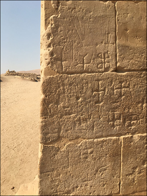
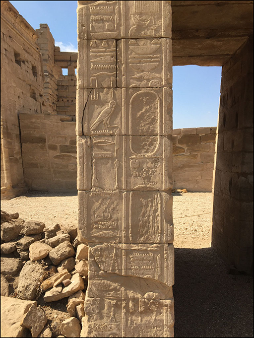
In 2020, the Coptic Project undertook fieldwork on Luxor’s West Bank (de Soto & Guimerà Reference de Soto and Guimerà2025), documenting more than 1517 Coptic graffiti and inscriptions (Figure 1) and 163 Christian structures, including churches, monasteries and hermitages (Figure 2). The graffiti are attributed to the Late Antique period based on their archaeological context, palaeographic characteristics and association with Christian occupation phases documented throughout the region.
Deir el-Medina, Temple of Hathor: Coptic graffiti on the east wall (photograph by authors).

Medinet Habu, Temple of Ramesses III: the Chapel of St Anthony located within the temple complex (photograph by authors).

Situated between the desert escarpment and the cultivated floodplain of the River Nile, this area of Upper Egypt experienced several major phases of occupation and religious transformation, including the development of Christian communities from the fourth century AD onwards. The West Bank therefore offers an exceptional setting for investigating the relationship between monastic communities, sacred space and transport infrastructures. Its rich archaeological record, combined with the preservation of ancient pathways and religious sites across the desert landscape, provides an ideal case study for exploring the historical processes that shaped connectivity and settlement dynamics in Late Antique Egypt.
Methods
The Coptic Project employs multidisciplinary methods, combining landscape archaeology, spatial analysis, transport network modelling and the study of textual and archaeological evidence. The research integrates data from systematic archaeological survey, documentary sources (including papyri) and the study of Christian settlements, transport infrastructures, inscriptions and graffiti within a unified geospatial framework.
Fieldwork conducted on Luxor’s West Bank focused on the systematic documentation of religious architecture, pathways and surface artefact distributions across a 100km2 study area. Archaeological features were recorded through pedestrian survey using standardised collection units, while all sites, pathways and off-site scatters were georeferenced under consistent visibility and recording criteria. This approach generated a high-resolution spatial dataset suitable for analysing settlement patterns, mobility and landscape organisation.
To investigate broader patterns of Christian occupation, all identified religious sites were integrated into a single geospatial database, including churches, monasteries and hermitages. For each site, the database records information relating to chronology, typology, state of preservation and archaeological context. These data provide the basis for examining the spatial distribution, development and evolution of Christian communities across Egypt (Brook Hedstrom Reference Brooks Hedstrom2017).
The archaeological dataset was subsequently combined with records of historical transport infrastructures, including roads, tracks, river routes and communication corridors, documented through archaeological, cartographic and remote-sensing evidence. The integration of these datasets enabled the application of GIS-based analyses and transport network modelling.
Network analyses were employed to calculate measures such as settlement density, connectivity and transport costs. These metrics permit examination of the relationship between monastic communities and wider systems of communication and exchange, providing a quantitative framework for investigating patterns of interaction across Late Antique Egypt.
Results
The integration of archaeological, textual and spatial datasets provides new evidence for investigating patterns of connectivity among Christian communities in Late Antique Egypt. Building upon previous scholarship that highlighted the economic and social integration of Egyptian monastic communities, the project offers a quantitative framework for evaluating how monasteries, churches and hermitages were positioned within wider systems of communication and exchange.
The West Bank of Luxor, like many desert and mountainous regions of Egypt, preserves abundant traces of abandoned Pharaonic and Greco-Roman settlements that are absent from modern topographic maps. The integration of field-survey data, topographic analysis and the digitisation of ancient transport routes has enabled the reconstruction of the transport network available to Late Antique communities and the evaluation of its role in structuring patterns of mobility and interaction (de Soto & Guimerà Reference de Soto and Guimerà2025).
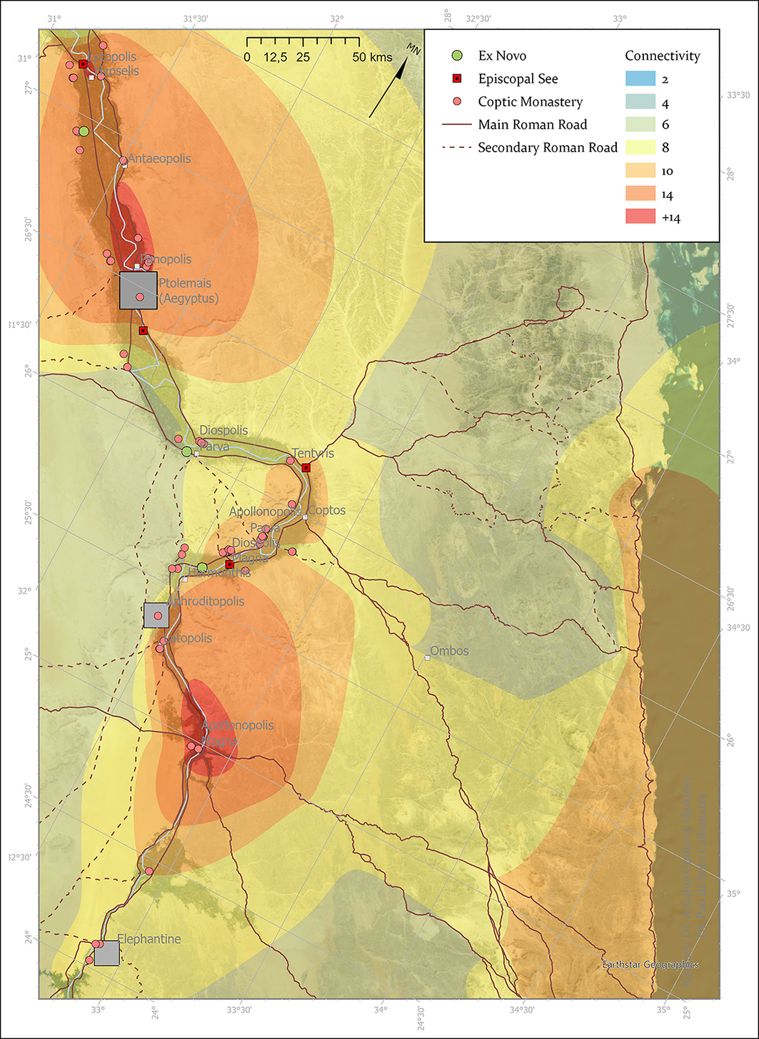
At the broader scale of the Egyptian landscape, connectivity analysis has proved essential for understanding the spatial organisation of settlement and mobility. Using weighted transport networks that incorporate roads, river routes and ports, connectivity was evaluated through network centrality (de Soto Reference de Soto and Verhagen2019). The results highlight significant variations in accessibility across Egypt and demonstrate the central role of both Nile-based and terrestrial transport corridors in structuring communication networks (Figure 3).
Connectivity model of transport routes and Christian settlements in the Thebaid, showing the main routes and connections between settlements; grey squares represent Roman-period Egyptian cities (figure by authors).

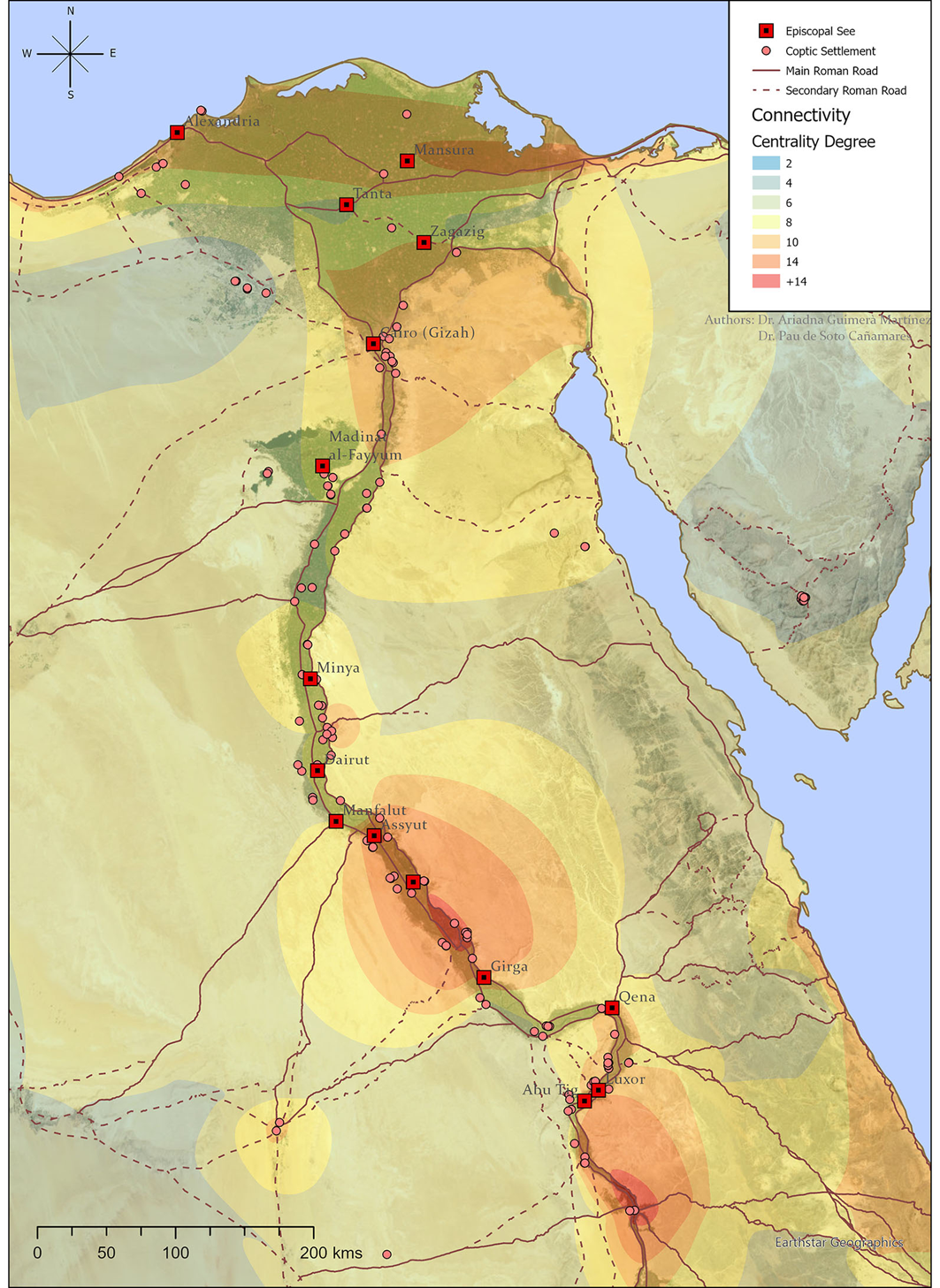
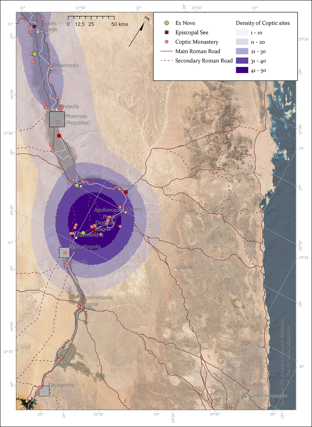
By estimating travel times, transport costs and probable movement routes, the analysis provides new insights into the spatial organisation of Christian communities and their relationship to wider systems of exchange (Figure 4). These models allow the identification of areas characterised by greater connectivity and accessibility, helping to contextualise the distribution of monasteries and churches within broader territorial frameworks (Figure 5).
Connectivity analysis of Late Antique Egypt. Node size and colour represent relative network centrality values calculated from the reconstructed transport network (figure by authors).

Density map of documented Christian settlements in the Thebaid based on the current project database; grey squares represent Roman-period Egyptian cities (figure by authors).

New perspectives: an Open Science initiative
The Coptic Project’s Open Science initiative supports the FAIR principles (Findable, Accessible, Interoperable and Reusable) by establishing a Spatial Data Infrastructure (SDI) compliant with European Union provisions on open data and the reuse of public sector information.
Although spatial databases and GIS offer clear potential for developing web-based archaeological resources, such practices remain far from standard. The Coptic Project seeks to change this by providing public access to its data collections through an online platform that will be launched in the beginning of 2027 and will allow users to model, interpret and visualise geospatial data, generate value-added outputs such as historical maps, and explore raw datasets and empirical records of the Coptic religious buildings via a map-based viewer with query functionality.
To ensure durability, the project implements a robust data-management framework with regular updates and maintenance. The platform will guarantee free access to all project data and promote interdisciplinary collaboration; users will be able to integrate the resource seamlessly into their work, fostering a culture of open and collaborative research.
Acknowledgements
The Coptic project uses the road networks data produced by the project Desert Networks (ERC-2017-STG, 759078) and the Itiner-e Project (Brughmans Reference Brughmans2024).
AI declaration
An AI-assisted tool (Claude Sonnet 5) was used exclusively for English-language editing and stylistic refinement of the manuscript.
Funding statement
The project receives funding by the following agencies and funding programmes: Ministry of Economy and Competitiveness (MINECO); Santander Bank Grant at Universidade de Coimbra (Portugal); Fondation Hardt (Switzerland); Juan de la Cierva Program (JDC2023-051285-I) of the Ministry of Science and Innovation (MICIN); Project Viator-e (RTI2018-098905-J-I00) funded by MCIN/AEI and by the European Regional Development Fund ‘A way of making Europe’. This work has been carried out within the framework of the Research Project Aismoc PID2024-159950NB-I00 (MCIN/AEI/10.13039/501100011033).

 Open access

