1. Introduction
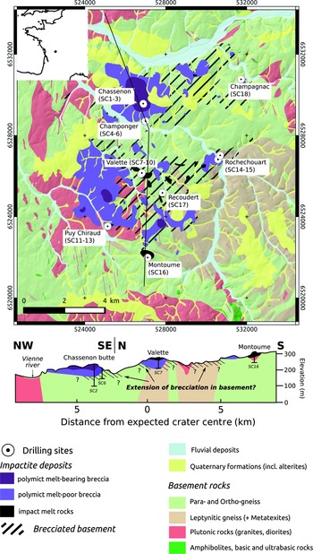
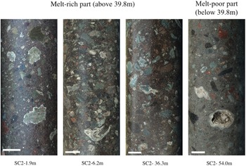
The Rochechouart impact structure is located near the NW edge of the French Massif Central (Limousin region; Fig. 1), and has been suggested to measure at least 12 km across based on the extent of the allochthonous breccia deposits (Lambert Reference Lambert1977), with an original crater diameter estimated to have been more than 15 km (Kraut & French, Reference Kraut and French1971). A gravity survey by Pohl et al. (Reference Pohl, Ernstson and Lambert1978) indicated an original diameter of 10–20 km, whereas other studies have proposed even larger crater diameters, such as 32 km (Osinski & Ferrière, Reference Osinski and Ferrière2016), and up to 40–50 km (Lambert, Reference Lambert, Gibson and Reimold2010). Nevertheless, a deep erosional level is expected, considering that c. 1100 m of basement rocks have been eroded since exhumation was initiated in the Early Cretaceous (François et al. Reference François, Barbarand and Wyns2020). The crater infill sequence is, at least locally, remarkably complete at Chassenon (north-central part of the area of impactites) where a fine-grained, impactoclastic layer is locally found overlying a graded suevite, landmarking the top of the sequence (Lambert, Reference Lambert, Gibson and Reimold2010) (Fig. 1). To obtain a better view of the sequence at Chassenon, three holes were cored as part of the 2017 drilling programme (Lambert et al. Reference Lambert2018). The longest of these cores, the 121.7 m deep SC2 hole, is described by Lambert et al. (Reference Lambert2018) to intersect 88 m of suevite and 25 m of basement breccia that seems to have a downward transition into more intact gneissic basement rocks (Fig. 2). This core does, however, not include the impactoclastite layer, which therefore is not within the scope of this study.
Geological map of the Rochechouart impact structure with locations of core holes from the 2017 drilling campaign (Lambert et al. Reference Lambert2018).

Representative core photos of the suevite (melt clast breccia) of the SC2 core. Lambert (Reference Lambert, Gibson and Reimold2010) divides the suevite into an upper, melt-rich part and a lower melt-poor part. Scale bars are 2 cm.

The age of the impact event has been subject to discussion (see Rasmussen et al. Reference Rasmussen, Stockli, Erickson and Schmieder2020). An age estimate based on isotopic techniques was obtained from outcropping impact melt rock at the Babaudus locality by Reimold and Oskierski (Reference Reimold, Oskierski and Pohl1987), which was 185.5 ± 2.2 Ma. Preliminary K–Ar ages of 150–170 Ma had already been presented from the same locality by Kraut and French (Reference Kraut and French1971). Later, from a pseudotachylyte sample from the Champagnac Quarry, Kelley and Spray (Reference Kelley and Spray1997) proposed a 40Ar/39Ar age of 214 ± 8 Ma. However, Schmieder et al., Reference Schmieder, Buchner, Schwarz, Trieloff and Lambert2010, Reference Schmieder, Jourdan, Tohver and Cloutis2014) suggested this age was presumably too old and they obtained an 40Ar/ 39Ar age of 201 ± 2 Ma from recrystallized K-feldspar in strongly impact-metamorphosed gneiss found near Videix, i.e. western-central domain of the Rochechouart structure. This age was then determined as 202.7 ± 2.2 Ma (recalculated in Jourdan et al. Reference Jourdan, Reimold and Deutsch2012) or 203 ± 2 Ma (Cohen et al. Reference Cohen, Mark, Lee and Simpson2017, using the decay constants and Fish Canyon sanidine standard age from Renne et al. Reference Renne, Balco, Ludwig, Mundil and Min2011). Cohen et al. (Reference Cohen, Mark, Lee and Simpson2017) running 40Ar/39Ar analysis of a surface sample of impact melt rock collected in Babaudus, obtained an age of 206.92 ± 0.20/0.32 Ma, and concluded that the Rochechouart impact structure predates the Triassic–Jurassic boundary by 5.6 ± 0.4 Ma and so is not temporally linked to the Triassic–Jurassic mass extinction. However, the relatively high age obtained by those authors could possibly be influenced by the incorporation of 40Ar from the target rocks (cf. Jourdan et al. Reference Jourdan, Renne and Reimold2007). In addition, Horne (Reference Horne2016) found a U–Th/He age of 191.6 ± 9.1 Ma (from the Montoume breccia and Babaudus impact melt rock) and two laser ablation – inductively coupled plasma – mass spectrometry (LA-ICP-MS) U–Pb age populations of 202.6 ± 5.8 Ma and 211 ± 13 Ma (from the Montoume breccia). More recently, Rasmussen et al. (Reference Rasmussen, Stockli, Erickson and Schmieder2020), by applying U–Pb depth profiling on the same Babaudus impact melt of Cohen et al. (Reference Cohen, Mark, Lee and Simpson2017), demonstrated that what is known as Former Reidite in Granular Neoblastic (FRIGN) zircon supports preserving a time of impact of 204–207 Ma. However, these authors found a younger age of 194 ± 2.9 Ma supporting the younger ages suggested by Horne (Reference Horne2016) and Reimold and Oskierski (Reference Reimold, Oskierski and Pohl1987), which they link to a post-impact thermal event unrelated to the impact. In consequence, even if a Late Triassic age is considered to be the current best estimate of the Rochechouart impact, an age a few million years younger cannot be excluded.
The location of the impact relative to the palaeo-sea is currently unknown as no marine sediments are known to cover the Variscan crystalline basement in the area. However, thin conglomerates have been suggested to have covered the Triassic peneplaine prior to the onset of marine sedimentation during the Early Jurassic (e.g. Cathelineau et al. Reference Cathelineau, Boiron, Fourcade, Ruffet, Clauer, Belcourt, Coulibaly, Banks and Guillocheau2012). Schmieder et al., Reference Schmieder, Buchner, Schwarz, Trieloff and Lambert2010) suggest that the impact occurred in a near-coastal to shallow marine location between the Tethys Ocean in the south and the Rhaetian Sea to the north, following a transgression initiated during the late Norian (e.g. Bourquin et al. Reference Bourquin, Robin, Guillocheau and Gaulier2002) or Rhaetian (e.g. Goldsmith et al. Reference Goldsmith, Hudson, van Veen, Evans, Graham, Armour and Bathurst2003). Schmieder et al., Reference Schmieder, Buchner, Schwarz, Trieloff and Lambert2010) further support this hypothesis by providing a review of published observations of potential seismites and tsunamites along palaeoshorelines of the Rhaetian Sea as far apart as southern France (e.g. Mader, Reference Mader1992) and the British Isles (e.g. Simms, Reference Simms2007), as well as of marine geochemical components in pseudotachylites at the Rochechouart crater (Kelley & Spray, Reference Kelley and Spray1997).
Relatively thick graded deposits of often suevitic character (i.e. significant melt particle content) are known to represent the uppermost parts of the impact-generated infill sequences in marine target craters, e.g. Lockne, Tvären, Chesapeake Bay, Flynn Creek, Wetumpka, Chicxulub (see summary in Ormö et al. Reference Ormö, Gulick, Whalen, King, Sturkell and Morgan2021). Visually, the graded suevite in SC2 shows many similarities with such deposits that formed by the oceanic resurge during the early stage of crater modification (cf. Ormö et al. Reference Ormö, Sturkell and Lindström2007). Here, we present results from visual core logging of the graded suevite in SC2. With this we aim not only to show the mode of deposition of the graded suevite in the Rochechouart crater, but also provide an assessment of the palaeogeography and timing of the impact event.
2. Methods
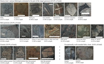
We have applied the same line-logging technique on the SC2 core as has been used on cores from several other marine target craters (e.g. Ormö et al. Reference Ormö, Sturkell and Lindström2007, Reference Ormö, Sturkell, Horton, Powars, Edwards, Gohn, Koeberl, Miller and Reimold2009, Reference Ormö, Gulick, Whalen, King, Sturkell and Morgan2021). A line is drawn along the core, and the granulometry and lithology of every clast ≥5 mm that touches the line are determined visually with standard geological field techniques (e.g. Coe et al. Reference Coe, Argles, Rothery and Spicer2010). In this study we note clast lithology, frequency, size, sorting, and roundness, both general and lithology-specific, and then treat this statistically as variations per metre length of the core. A total of 6002 clasts were logged and first separated into 18 distinctive sub-classes. For simplicity, these were then grouped into four main classes: (1) melt particles (brown, green and white); (2) gneiss (includes various lithologies determined to be part of the gneiss suite of the area); (3) granite; and (4) a small group of exceptionally well-rounded lithic clasts (hereafter EWRLC) (Fig. 3). The applied method allows evaluation of the target environment (i.e, aquatic or land) by analysing the sedimentology of the clastic deposits in the SC2 core in comparison with known marine target craters studied using the same method. A more detailed study of the clast lithologies (e.g. the potential variations among the melt particles) is beyond the scope of this study. The emphasis is instead on their relative variations along the core.
Clast classification. Scale bars are 1 cm.

3. Results
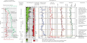
The results from the line-logging and statistical analysis are presented in Fig. 4. Of the 6002 logged clasts 63.6 % are gneiss, 10.9 % granite, 18.4 % green melt, 5.5 % white melt, 0.9 % brown melt and 0.6 % EWRLC. The lithologies of the 38 EWRLC clasts are either igneous (granitic with mainly milky quartz) or metamorphic (quartzite) (Fig. 3), likely originating from a thin, reworked residue after the Permian–Triassic weathering of the crystalline basement described by Cathelineau et al. (Reference Cathelineau, Boiron, Fourcade, Ruffet, Clauer, Belcourt, Coulibaly, Banks and Guillocheau2012). Further rounding of the clasts may have occurred by fluvial or shoreline processes. It is important to note that no clasts of sedimentary rock have been detected. Clasts that represent direct lithological fragments of the target (i.e. gneiss, granite and EWRLC) occur relatively evenly throughout the logged section (Fig. 4). The most obvious variation is seen for the melt particles. Below 88 m melt particles are nearly absent. At 88 m there is a sudden increase, and up to 38.9 m the amount varies around 17 % with a peak at c. 80 m and a low at 60 m. At 38.9 m there is another sudden increase to c. 45 % that, with some fluctuations (25 m, 15 m, 5 m), continues to the top of the core. There is also a clear variation in the colour of the melt particles (e.g. white is more common at levels with relatively high melt clast abundance), but the reason for the colours of the melt particles is not analysed any further in this study.
Graphs showing variations in granulometry and clast lithology in the graded suevite of the SC2 core. Inset to the left are graphs from a similar logging by Ormö et al. (Reference Ormö, Sturkell and Lindström2007) of the Lockne-2 core at the marine target Lockne crater, Sweden. The interpretation to the right is based on comparisons with line-logging results from similar deposits at several other impact craters (e.g. Ormö et al. Reference Ormö, Sturkell and Lindström2007, Reference Ormö, Sturkell, Horton, Powars, Edwards, Gohn, Koeberl, Miller and Reimold2009, Reference Ormö, Gulick, Whalen, King, Sturkell and Morgan2021; Sturkell et al. Reference Sturkell, Ormö and Lepinette2013; De Marchi et al. Reference De Marchi, Ormö, King, Adrian, Hagerty and Gaither2019), but Lockne-2 is considered to provide the best analogy to the Rochechouart SC2 core.

The size sorting throughout the logged section fluctuates around a mean of c. 1, i.e. moderately to poorly sorted (Folk, Reference Folk1974). Clast frequency, size and sorting are related to each other as follows:
In the zone between 105 m and 103 m the curves obtain some structure after having been completely chaotic below 105 m. Clear reverse grading (i.e. upwards increase in clast size, but reduction in clast frequency and sorting) occurs between 103 m and 79 m. There then follows a normally graded interval 79−61 m. In the interval 61−39.8 m there is again a decrease in the number of clasts towards the top. As this is not accompanied by an increase in clast size it is more likely a consequence of increased matrix content (i.e. mud). At 61 m, or possibly even as early as 63 m, the first significant change in roundness occurs, with a general increase in angularity towards the top of the 61−39.8 m interval. A drastic shift in the clast frequency (increase), size (increase), sorting (reduction) and lithology (high melt particle content) occurs at 39.8 m. However, this is followed by a normal graded sequence. The size sorting also gradually increases upwards. This interval also sees a general increase in the amount of melt, notably white and brown melt.
In the interval 39.8−0 m there then occurs a set of repetitions in clast frequency and size, although sorting generally improves until a fluctuation occurs at 6 m below the top of the logged section. At 33 m, roundness shows a distinct increase, but then again decreases slightly to the top until the topmost 6 m where it again shows a distinct fluctuation.
The uppermost 6 m of the core is characterized by a drop in clast frequency coupled with an increase in clast size, as well as poorer sorting. As the clasts are still mainly larger than the 5 mm cut-off, this grain-size drop is considered to be real and not an artefact (cf. Ormö et al. Reference Ormö, Sturkell and Lindström2007, Reference Ormö, Gulick, Whalen, King, Sturkell and Morgan2021). Altogether, this indicates increased matrix content. The higher angularity of clasts is coupled with the increased melt content, which includes more brown melt. This is distinctively different from that of the impactoclastite layer described by Lambert (Reference Lambert, Gibson and Reimold2010) as ‘ash-like horizontal deposit of very glass-poor, fine-grained, lithic debris derived from basement rocks’. Instead, it is more likely a strongly mud-charged suspension flow with angular, more distal (i.e. higher shocked) ejecta. It is common for the finer-grained top parts of resurge deposits to have a higher content of shocked material (Therriault & Lindström, Reference Therriault and Lindström1995). At Chicxulub, increased angularity is coupled with an increased amount of melt fragments, possibly forming shards after rapid quenching in contact with seawater (Osinski et al. Reference Osinski, Grieve, Hill, Simpson, Cockell, Christeson, Ebert, Gulick, Melosh, Riller, Tikoo and Wittmann2020). The circle diagrams in Fig. 5 show that also at Rochechoart the melt clasts express a high angularity. Likewise, the granite clasts show a higher angularity than that of the gneiss (possibly an effect of rheology), but they are relatively few and evenly distributed along the core, thus not affecting the general roundness graph to the same degree.
Degree of roundness of the main clast lithologies except EWRLC. Melt particles are notably the most angular.

4. Discussion
4.a. Palaeoenvironmental implications
There are clear trends in the data graphs (Fig. 4), which allow comparisons with published data on cores from other craters with similar deposits (see review in Ormö et al. Reference Ormö, Gulick, Whalen, King, Sturkell and Morgan2021). Of those, the Lockne-2 core is most similar with respect to clast frequency, size and sorting variations (Fig. 4). In addition, the Chicxulub M0077A core also shows conspicuous similarities with respect to lithology distribution and roundness variation (cf. Ormö et al. Reference Ormö, Gulick, Whalen, King, Sturkell and Morgan2021). The chaotic appearance of the curves below 105 m indicates avalanche and slump deposits with little or no influence from water. However, the organization that occurs in the interval 105−103 m is known from previously studied craters to indicate an often relatively short transition zone in which there is an initiation of transport and deposition in water (e.g. Ormö et al. Reference Ormö, Sturkell and Lindström2007, Reference Ormö, Sturkell, Horton, Powars, Edwards, Gohn, Koeberl, Miller and Reimold2009, Reference Ormö, Gulick, Whalen, King, Sturkell and Morgan2021; Sturkell et al. Reference Sturkell, Ormö and Lepinette2013). Figures 4 (right column) and 6 describe the depositional process and the dynamics of the water flow; deposition out of suspension begins at 103 m and then dominates upwards. The upwards following trends are also seen in the relatively deep-marine resurge deposits at Lockne (target water depth H ∼ 500 m), but also to some extent at Chicxulub (H ∼ 2000 m). At both Lockne and Chicxulub, a forceful resurge passed in over the crater floor, causing mainly rip-up and traction along the floor, but little deposition (i.e. the transition zone 105−103 m). At Lockne, where water can enter from all directions, a ‘Central Water Plume’ (CWP) forms. It is after the collapse of the CWP and the initiation of an anti-resurge that the major deposition begins (Ormö et al. Reference Ormö, Sturkell and Lindström2007). A mud-rich deposit carrying a high amount of basement rip-up clasts is dumped rapidly when the transport energy temporarily drops. This is followed by oscillations within the crater causing a set of repeated beds although with a general fining-up. At Chicxulub there is no indication of the formation of a CWP. However, a collision of flows diverted around the peak ring caused a second pulse in energy with similar consequences to the deposition. All in all, the granulometry displayed in the Rochechouart SC2 core from 103 m depth and to the top is typical for a suspension deposit created bya forceful flow capable of keeping a huge amount of material in suspension (cf. Ormö et al. Reference Ormö, Gulick, Whalen, King, Sturkell and Morgan2021).
Schematic process reconstruction of Stage 5 of the resurge at the Rochechouart crater (Fig. 4). As currently the size and morphology of the fresh crater are not known, the cross-section is only meant to be seen as conceptual in order to explain the various interpreted mechanisms of the resurge process, e.g. collision of flow, MWI, pulse of reflected wave. The conceptual cross-section chosen here is that of a complex crater, as the consensus of current published estimates is that of a crater with a diameter much wider than the transition from simple to complex morphology. However, in a much larger option, the central uplift indicated here could be replaced by a peak ring. The location of the drill hole SC2 is indicated, as well as the likely nearshore position of the crater.

At Lockne, the combination of target and relative water depth did not generate any melt particles of sizes above the 5 mm cut-off. However, in Unit 2 in the Chicxulub M0077A core the amount, size distribution and shapes of melt particles are similar to those of the SC2 core. For Chicxulub, Ormö et al. (Reference Ormö, Gulick, Whalen, King, Sturkell and Morgan2021) suggested the melt particles to, at least partially, originate from interaction between the resurge and large melt pools on the crater floor (‘Melt-Water-Interaction, MWI’, cf. Osinski et al. Reference Osinski, Grieve, Hill, Simpson, Cockell, Christeson, Ebert, Gulick, Melosh, Riller, Tikoo and Wittmann2020). Notably, at Chicxulub angular clasts (also here often melt particles) are kept longer in suspension than rounded clasts (Ormö et al. Reference Ormö, Gulick, Whalen, King, Sturkell and Morgan2021).
Deposits such as in SC2, Lockne-2 and Chicxulub M0077A indicate a transport as hyperconcentrated flows (see discussion in Ormö et al. Reference Ormö, Gulick, Whalen, King, Sturkell and Morgan2021). This means a flow with 20–60 vol. % of material in suspension (Vallance, Reference Vallance and Sigurdsson2000). Considering the relatively low amount of clasts per metre (an average of 58) in SC2 compared with Lockne-2 (85) and Chicxulub M0077A (72) (cf. Ormö et al. Reference Ormö, Gulick, Whalen, King, Sturkell and Morgan2021) despite a similar mean clast size, most likely the sediment load was at the higher end of that span. Assuming a sediment load of 50 vol. % for the Rochechouart resurge, the overall thickness of the SC2 resurge deposits (>103 m) would indicate a flow depth of ∼200 m. Numerical simulations of resurge flows at Lockne and Tvären indicate that the depth of the target sea would be in the same order (Ormö et al. Reference Ormö, Lepinette, Sturkell, Lindström, Housen, Holsapple, Gibson and Reimold2010). Less water, if at all able to pass the elevated rim, would have generated a complex set of debris flows similar to relatively shallow-water impacts such as Wetumpka (King et al. Reference King, Ormö, Petruny and Neathery2006; Ormö et al. Reference Ormö, Gulick, Whalen, King, Sturkell and Morgan2021).
After having established that the deposits in the SC2 core require a significant amount of water for the transport we can conclude that the Rochechouart impact occurred in a marine setting. A water depth of 200 m is plausible for such a seaway over the Massif Central (J Fischer, pers. comm. 2021). However, the absence of any sediment clasts in the SC2 resurge deposits indicates that there may not have been enough time between the transgression and the impact for the formation of substantial volumes of lithified sedimentary rock.
4.b. The case for a nearshore impact event, and possible size of the crater
In a conceptual reconstruction of the process of water resurge we have placed a complex crater in a nearshore position (Fig. 6). The distribution of potentially water-deposited suevite within the Rochechouart crater indicates that deeper water was located to the west or the northwest (Fig. 2). When the resurge from the oceanic side passes in over the crater floor it may, in analogy to what is suggested for Chicxulub (e.g. Ormö et al. Reference Ormö, Gulick, Whalen, King, Sturkell and Morgan2021), cause rip-up and MWI processes when interacting with the impact breccias and large melt pools that still today are visible in the crater interior (Fig. 1). When the resurge reaches a major topographic obstacle such as a central peak, or the far end of the crater, the reflected wave would generate a similar anti-resurge effect to that seen in Chicxulub and in the collapse of the CWP at Lockne (cf. Ormö et al. Reference Ormö, Gulick, Whalen, King, Sturkell and Morgan2021). As no melt bodies are seen at the SC2 site, any MWI at Rochechouart likely occurs somewhere away from the SC2 location, possibly from the larger melt pools today seen further to the east (Fig. 1). Melt particles would then be transported to the SC2 site in suspension, and, as at Chicxulub, angular fragments are kept longer in suspension. While the crater continues to fill up, a second pulse of higher flow energy reaches the SC2 site, causing the increase in transport energy seen at 39.8 m (Figs. 4, 6). The water infill continues in a set of oscillations and seiches similar to what is described from Lockne and Chicxulub. Later erosion leaves the structure and impactite distribution seen today (François et al. Reference François, Barbarand and Wyns2020).
In addition, providing important evidence for a marine target environment, sedimentological studies of resurge deposits from marine target craters by Ormö et al. (Reference Ormö, Gulick, Whalen, King, Sturkell and Morgan2021), and further mathematical analysis by Herreros and Ormö (Reference Herreros and Ormö2022), indicate a relation between mean clast frequency (<N>), impactor diameter (d) and target water depth (H) that allows the estimate of any of these variables when the two others are known through independent sources. Equation 1 represents a location of the cored sediment in a low position of the crater (e.g. moat), and Equation 2 represents a relatively high position in the crater (e.g. central uplift area), or possibly a more turbulent position (Ormö et al. Reference Ormö, Gulick, Whalen, King, Sturkell and Morgan2021; Herreros & Ormö, Reference Herreros and Ormö2022):
 $$ \lt N \gt = - 15\left( {d/H} \right) + 100$$
 $$ \lt N \gt = - 13\left( {d/H} \right) + 150$$
Applying Equation 1 with <N> = 58, H = 200 m gives a projectile size of ∼560 m, and for Equation 2 it is 1400 m. Tagle et al. (Reference Tagle, Schmitt and Erzinger2009) argue that the impactor at Rochechouart most likely was an iron asteroid. A 600 m iron projectile gives, according to the impact-effect calculator down2earth.eu (accessed May 2021) a crater diameter of 13 km for an impact velocity of 18 km s−1 at 45° impact angle into a target of igneous rock. This would correlate with the distribution of impactites in the Rochechouart structure (Fig. 1). The same calculation for a 1400 m iron projectile gives a crater diameter of 28 km, which is similar to other suggested crater diameters (see Introduction). However, considering the relatively short core drillings, the scarcity of detailed geophysical data, the current lack of independent data on the target water depth, and the uncertainty of the position of the SC2 drill site relative to the pre-erosion geomorphology of the fresh crater, at this stage there are too many uncertainties for the results to be conclusive concerning the size of the fresh crater. The crater diameters obtained here can thus only be seen as indicative.
4.c. Palaeogeographical implications
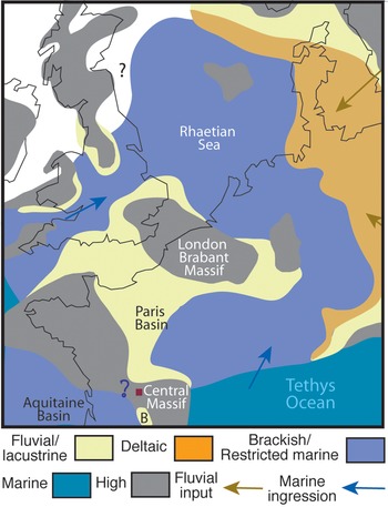
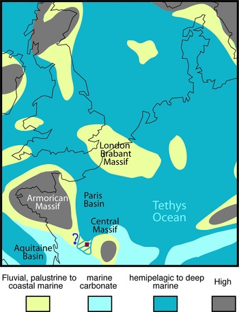
Depending on the age considered, i.e. Rhaetian or Early Liassic (see Introduction), the palaeogeographic reconstructions will differ. For the Late Triassic, Scotese and Schettino (Reference Scotese, Schettino, Soto, Flinch and Tari2017) consider that the marine Rhaetian sandstones, i.e. deltaic, are limited east of the Paris Basin. However, Bourquin et al. (Reference Bourquin, Vairon and Le Strat1997, Reference Bourquin, Robin, Guillocheau and Gaulier2002) and Fischer et al. (Reference Fischer, Voigt, Franz, Schneider, Joachimski, Tichomirowa, Götze and Furrer2012) show that the restricted marine Rhaetian Sandstones grade westward to dolomitic coastal sabkha. i.e. brackish deposits, and to fluvial lacustrine deposits. During the Rhaetian, Bourquin et al. (Reference Bourquin, Vairon and Le Strat1997, Reference Bourquin, Robin, Guillocheau and Gaulier2002) describe the first connection between the Paris and England basins and a new depocentre southwest of the Paris Basin, i.e. south of Tours, with maybe a connection of the fluvial sedimentation area with the Aquitaine Basin (Fig. 7). In that area, Rauscher et al. (Reference Rauscher, Merzeraud and Schuler1992) and Merzeraud et al. (Reference Merzeraud, Hoffert, Verdier and Rauscher1999, Reference Merzeraud, Rauscher, Hoffert and Verdier2000) consider Rhaetian fluvial deposits to be influenced by marine waters and connected with a coastal plain, and that the marine influence increased during the Early Liassic with mainly coastal plain environments grading laterally to calcareous marine deposits. In consequence, a possible connection between the Paris and Aquitaine basins could be envisaged in particular during the Early Jurassic (Fig. 8) following the major marine Sinemurian flooding in this area (cf. Cathelineau et al. Reference Cathelineau, Boiron, Fourcade, Ruffet, Clauer, Belcourt, Coulibaly, Banks and Guillocheau2012). The Sinemurian spans c. 6.6 Myr (Cohen et al. (Reference Cohen, Finney, Gibbard and Fan2013). In the Aquitaine Basin, during the end of the Triassic and the early Early Jurassic, i.e. Rhaetian to Hettangian, brackish sedimentation is observed in the Aquitaine Basin (i.e. Dercourt et al. Reference Dercourt, Gaetani, Vrielynck, Barrier, Biju-Duval, Brunet, Cadet, Crasquin and Sandulescu2000; Boiron et al. Reference Boiron, Cathelineau, Banks, Buschaert, Fourcade, Coulibaly, Boyse and Michelot2002). In the area of Rochechouart (Fig. 7), only Rhaetian fluvial deposits outcrop in the Brive area (Astruc et al. Reference Astruc, Cubaynes, Fabre, Galharaghe, Lefavrais-Raymond, Marcouly, Pélissié, Rey and Simon-Coinçon1995) and the Hettangian sedimentation is characterized by palustrine or lagoon deposits (Le Pochat et al. Reference Le Pochat, Floc’h, Platel and Recoing1986; Astruc et al. Reference Astruc, Cubaynes, Fabre, Galharaghe, Lefavrais-Raymond, Marcouly, Pélissié, Rey and Simon-Coinçon1995). In conclusion, given that the impact according to our estimates occurred under ∼200 m of marine water, either the palaeogeographic reconstruction of the Rhaetian must be reconsidered, or the impact would have occurred in the Early Jurassic after a rapid enough transgression not to produce any consolidated sediments or calcareous mud of any quantities detectable by applying HCl to the core.
Rhaetian palaeogeographic reconstruction of Fischer et al. (Reference Fischer, Voigt, Franz, Schneider, Joachimski, Tichomirowa, Götze and Furrer2012) modified from Bourquin et al. (Reference Bourquin, Vairon and Le Strat1997, Reference Bourquin, Robin, Guillocheau and Gaulier2002). B: Brive area.

Early Jurassic palaeogeographic reconstruction (Hettangian and Sinemurian). Modified from Dercourt et al. (Reference Dercourt, Gaetani, Vrielynck, Barrier, Biju-Duval, Brunet, Cadet, Crasquin and Sandulescu2000) and Scotese and Schettino (Reference Scotese, Schettino, Soto, Flinch and Tari2017).

5. Conclusions
Sedimentological analysis of the suevite deposits at the SC2 core near Chassenon gives evidence for a shallow marine target environment for the Rochechouart impact with ∼200 m water depth. More generally the Rochechouart impact can be used to further constrain the palaeotopography, palaeoenvironment and erosional history of the western edge of the French Massif Central. Likewise, our results would, in the current view of the Rhaetian palaeogeography, indicate an age of formation during the Early Jurassic. In any case, the obvious marine target setting calls for further attention to the date of the event.
Acknowledgements
The work by JO was supported by grants ESP2017-87676-C5-1-R and PID2021-125883NB-C22 by the Spanish Ministry of Science and Innovation/State Agency of Research MCIN/AEI/ 10.13039/501100011033 and by ‘ERDF A way of making Europe’, the Spanish State Research Agency (AEI) Project No. MDM-2017-0737 Unidad de Excelencia ‘María de Maeztu’–Centro de Astrobiología (CAB) CSIC-INTA, the Spanish Research Council (CSIC) support for international cooperation: I-LINK project LINKA20203, and Centre for International Research on Impacts and Rochechouart (CIRIR). PL was supported by the CIRIR funds from the local communities of ‘Porte Océane du Limousin’ and ‘Charente Limousine’.
Conflict of interest
None.