INTRODUCTION
Atolls are often described as “marginal” environments for human habitation. Typically, they have low biodiversity and a high susceptibility to storms and other adverse weather events, and also tend to be physically isolated (Weisler Reference Weisler2001a, Reference Weisler2001b; Fitzpatrick and Anderson Reference Fitzpatrick and Anderson2008; Thomas Reference Thomas2009; Kirch Reference Kirch2017). Despite these conditions, humans are known to have inhabited Pacific atoll islands for 2000 years or longer (Weisler Reference Weisler1999a, Reference Weisler2001a, Reference Weisler2001b; Yamaguchi et al. Reference Yamaguchi, Kayanne, Yamano, Najima, Chikamori and Yokoki2005; Dickinson Reference Dickinson2009; Weisler et al. Reference Weisler, Yamano and Hua2012; Carson Reference Carson2018). During this time, they appear to have engaged in marine and terrestrial food procurement methods as well as terrestrial production strategies. Thus, atolls represent an important example of thriving in “marginal” conditions, and, in fact, present a challenge to defining “marginality” in human environments (e.g., Fitzpatrick et al. Reference Fitzpatrick, Thompson, Poteate, Napolitano and Erlandson2016; Harris and Weisler Reference Harris and Weisler2018).
Petersen (Reference Petersen2006, Reference Petersen2009) argues that atolls played a key role in the cultural and agroecological development of Micronesia. More data, such as those from this project, are needed from atolls in the region in order to examine this argument. One of the Micronesian atolls that has been the subject of recent archaeological investigations is Mwoakilloa, which is located 115 km northwest of Pingelap. Poteate and colleagues (Reference Poteate, Fitzpatrick, Ayres and Thompson2016) demonstrated that Mwoakilloa had been inhabited by humans and commensal species as early as 1700 cal BP (2σ). Given that Pingelap has a similar environment and is one of Mwoakilloa’s closest neighbors, it was likely settled around the same time, a hypothesis that is supported by the preliminary results of our fieldwork.
In this paper, we consider the questions of (a) the settlement sequence of Pingelap, including the current earliest known dates; and (b) how humans modified this environment to meet their needs. To address these questions, we conducted surface survey, excavated three test pits, and collected materials for zooarchaeological and archaeobotanical analysis as well as accelerator mass spectrometry radiocarbon (AMS 14C) dating.
BACKGROUND
Humans colonized central-eastern Micronesia around 2000 BP (Rainbird Reference Rainbird2004; Carson Reference Carson2018). This region, broadly defined here as Pohnpei, Chuuk, and Kosrae States in the Federated States of Micronesia (Figure 1), was first settled by Lapita descendants who arrived from the Solomon Islands, Vanuatu (Rainbird Reference Rainbird2004; Kirch Reference Kirch2017), and/or the Bismarck Archipelago (Lebot et al. Reference Lebot, Merlin and Lindstrom1992). Monumental architecture has been a major focus of much archaeological research in the region, as it is important to understanding the socio-politics of the past. These monumental sites include Nan Madol (e.g., Athens Reference Athens1980, Reference Athens1990; Ayres Reference Ayres1993; Ayres and Scheller Reference Ayres, Scheller, Sand and Burley2003; Ayres et al. Reference Ayres, Seikel and Levin2009, Reference Ayres, Levin and Seikel2015; Seikel Reference Seikel2011, Reference Seikel2016; McCoy and Athens Reference McCoy and Athens2012; Ayres and Seikel Reference Ayres, Seikel, Martinsson-Wallin and Thomas2014; McCoy et al. Reference McCoy, Alderson and Thompson2015, Reference McCoy, Alderson, Hemi, Cheng and Edwards2016) and Lelu on Kosrae (e.g., Cordy Reference Cordy1982, Reference Cordy1985, Reference Cordy1993; Ueki Reference Ueki1984; Richards et al. Reference Richards, Shen, Hobbs, Wu, Jiang and Beardsley2015). However, smaller archaeological sites, representing the lives of non-elites, have also attracted some interest (e.g., Ayres and Mauricio Reference Ayres, Mauricio, Ucko and Layton1999; Haun Reference Haun1984; Mauricio Reference Mauricio1993; Levin Reference Levin2015, Reference Levin2016, Reference Levin2018; Poteate et al. Reference Poteate, Fitzpatrick, Ayres and Thompson2016; Levin and Ayres Reference Levin and Ayres2017; Levin et al. Reference Levin, Shelton and Ayres2017). These sites are important to understanding settlement and subsistence patterns and how humans engaged with their environments, as well as how the wider community was integrated into and interacted with highly stratified socio-political regimes.
Micronesia regional map, indicating the location of Pingelap Atoll. Drafted by Joel Butler.

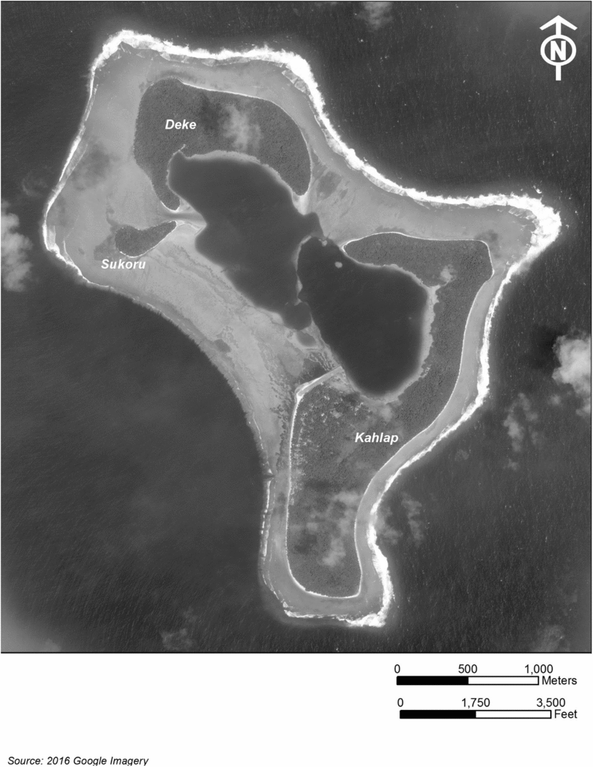
Pingelap is located in central-eastern Micronesia at 6º13′N and 160º42′W (Damas Reference Damas1985) and is politically part of Pohnpei State in the Federated States of Micronesia. It consists of three islets, totaling approximately 1.8 km2. These islets are, from largest to smallest, Kahlap, Deke, and Sukoru. Only the largest, Kahlap, is currently inhabited. The modern village, visible on the aerial map (Figure 2), is located on the central-western area of Kahlap, facing both the southern portion of the lagoon (in the north) and the Pacific Ocean (in the west and south). A community taro patch is located directly to the east of the village. Current residents report that there are approximately 170 full-time residents on Pingelap, although a much larger number of Pingelapese people live on Pohnpei, Guam, Hawai’i, and the U.S. mainland.
Aerial map of Pingelap Atoll. Drafted by Joel Butler.

The climate of Pingelap is similar to that of the high island of Pohnpei, as it is located within the same moisture belt (Damas Reference Damas1985), with rainfall fairly consistent throughout the year. Average daily temperatures range from approximately 24–32ºC year-round (NOAA 2018). Typhoons periodically make landfall and can cause significant destruction.
Davidson (Reference Davidson1967) and Rosendahl (Reference Rosendahl1977) conducted early reconnaissance work on Pingelap as part of larger projects. Rosendahl’s work resulted in the identification of a midden and surface artifact concentration (Pi-1), which has yet to be relocated. Pingelapese residents reported that a group of European archaeologists conducted an excavation in the 1990s; however, we have been unable to locate any associated reports. In the summer of 2016, Levin traveled to Pingelap to initiate archaeological work, conducting reconnaissance survey with the assistance of the Pohnpei Historic Preservation Office (HPO) and Pingelapese residents. The team recorded five historical sites, as well as several other landmarks of historical and contemporary interest to the Pingelapese community. These include the World War II Japanese military base, the village on Deke occupied by the Pingelapese during Allied bombing of the Japanese base during WWII, multiple cemeteries, and island locations prominent in local oral histories. During the 2017 field season, the project team set out to begin developing a settlement and subsistence chronology for the atoll.
METHODS
Project personnel determined the locations of test units based on the intention to construct a preliminary settlement history for Pingelap and to examine land use practices (Figure 3). Following procedures from previous atoll studies (e.g., Thompson Reference Thompson2010; Poteate et al. Reference Poteate, Fitzpatrick, Ayres and Thompson2016), which have indicated that points of high elevation on atolls are likely to represent long-term settlement and that central areas have the longest occupation because of a larger freshwater lens (e.g., Riley Reference Riley1987; Best Reference Best1988; Weisler Reference Weisler1999a; Yamaguchi et al. Reference Yamaguchi, Kayanne, Yamano, Najima, Chikamori and Yokoki2005; Thomas Reference Thomas2009; Weisler et al. Reference Weisler, Yamano and Hua2012) excavation started with a test unit near a high point of Kahlap (Test Unit 1). In order to examine past farming practices, test units were also opened near the taro patch (Test Unit 2) and an agroforest area (Test Unit 3).
Test unit and shovel test locations. Drafted by Joel Butler.

All test units were excavated in 10-cm increments, and soil was screened through quarter-inch wire mesh. All artifacts and faunal remains were collected during screening. Most layer transitions were quite gradual, frequently occurring over a 5–10 cm range; however, where abrupt changes in the layers were observed, notably with the appearance of a bone concentration feature in Test Unit 1, materials were bagged separately. Charcoal samples were periodically collected for AMS dating where present, with their three-dimensional coordinates recorded. Additionally, at least one bulk sediment sample for plant microremain analysis was collected from each 10-cm level. Finally, a minimum of 10 L of soil from each level was collected and floated off-site near the shore, using strained seawater for flotation. Light fractions were collected using a fine nylon mesh (approximately 0.25 mm) and dried. Heavy fractions were screened with 1-mm mesh, retaining a large quantity of smaller faunal material. While these cannot be directly compared with the quarter-inch screen samples, they provide additional data on smaller taxa. Five shovel tests, approximately 30 cm in diameter and reaching a depth of 80–90 cm, were also conducted near the airstrip, although they yielded only modern hurricane debris and are thus not discussed further.
Additionally, the research team conducted survey, focusing on the identification and GPS plotting of archaeological sites and places important in local oral histories. The team worked with traditional and municipal leaders and knowledgeable community members to identify sites of interest to the community as well as locations that might contain archaeological features and subsurface deposits. All work was conducted in coordination with the Pohnpei State Historic Preservation Office, the National Historic Preservation Office of the Federated States of Micronesia, the traditional and municipal leaderships of Pingelap, and local landowners.
RESULTS
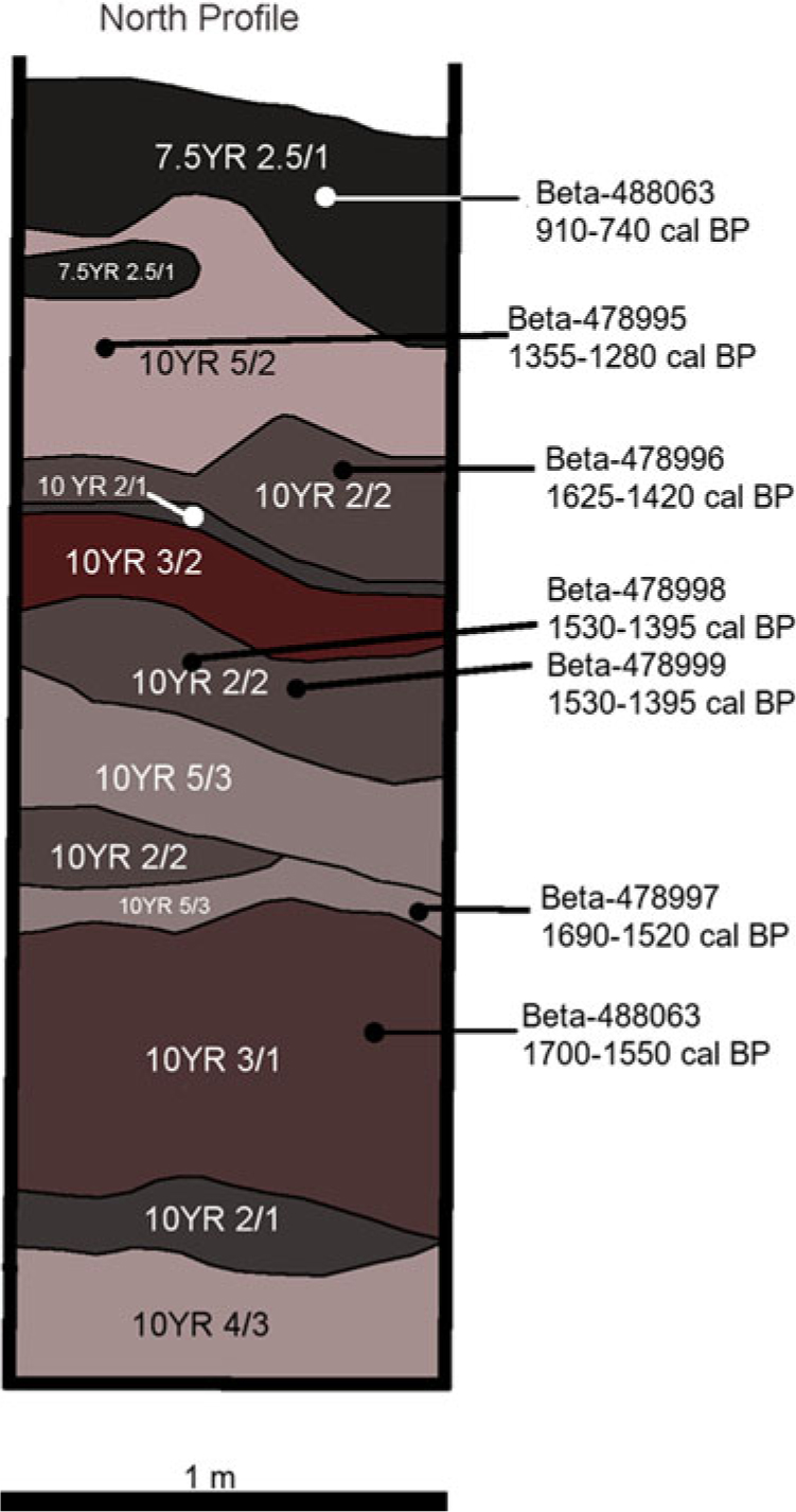
Test Unit 1 (Figure 4) was excavated next to an abandoned house near the high point of Kahlap. The unit was 1 × 1 m square and 3 m deep. The excavation of the unit was terminated due to the presence of a large coral rock uncovered between 2.8 and 3 m below ground surface (which could not be safely removed) and did not reach the base of the cultural deposits. Historical debris was encountered to a depth of 32 cm, at which point excavators encountered soils containing a large amount of degraded coral. Beginning at 88 cm a dense fish bone concentration was identified, which became progressively less dense over the next 40 cm. Approximately 75% of the soil from the concentration was collected and floated to ensure the retention of as many small fish bones as possible. Faunal remains were documented throughout the excavation to a depth of three meters. All sediments were relatively unconsolidated and coraline, which is typical for atoll settings (Weisler et al. Reference Weisler, Yamano and Hua2012). Changes in color from layer-to-layer are likely due to variable organic matter content.
Test Unit 1 North soil profile, with locations of AMS dates indicated.

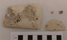
Only four prehistoric artifacts were recovered in Test Unit 1: two small beads, a Tridacna adze, and half of a perforated shell ornament (Figure 5). All of these artifacts were recovered below two meters. Although the adze exhibits usewear damage, residue extraction revealed no diagnostic phytoliths or starch. Historical artifacts, all recovered in the first 32 cm, include eight nails or nail fragments, four bottles (two of which were medicine bottles) with identifiable maker’s marks, three glass shards with potentially identifiable characteristics or markings, two metal pull tabs, five non-matching buttons, the bottom portion of a can of Spam (purposefully cut), a fragment of a plastic cup, and a metal pin or brooch with a floral or butterfly design. The maker’s marks on the bottles date to the mid-20th century, and the other artifacts recovered are consistent with this time-frame. Additionally, the abandoned house nearby appears to have been constructed and occupied in the mid-20th century. Prehistoric artifacts were returned to the Pohnpei Historic Preservation Office in Kolonia after documentation and analysis at Stanford University, and historical artifacts remained on Pingelap with the municipal government.
Prehistoric artifacts recovered from Test Unit 1.

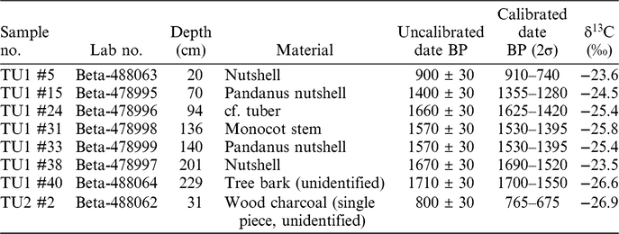
Seven AMS 14C dates have been analyzed from charred botanical material within the deposit (Table 1). Where possible, short-lived plant materials were selected, although this was not possible in all cases. However, the heartwood from dicotyledon trees was avoided, as this has the greatest potential for inbuilt age. The monocot stem sample (Beta-478998) may be from a palm, which is long lived, although the date derived from this sample was identical to the date derived from a short-lived sample in the same context, indicating that it is unlikely to contain inbuilt age. The dates from the tree bark sample (Beta-488064) is also only slightly older than that from the nutshell in the layer above (Beta-478997), suggesting the date is accurate for the cultural sequence.
14C dates from Pingelap Atoll excavations.

Except for TU1 #24, dates are stratigraphically consistent. All prehistoric artifacts were situated below the 1690–1520 cal BP (2σ) date, placing initial human settlement of the atoll in the early first millennium AD at the latest. Additional excavations in future field seasons will help determine if settlement is continuous, or if there were interruptions in the second millennium AD. It should be noted that in the top layer, historical materials are intermixed with the 910–740 cal BP (2σ) date.
Comprehensive analysis of the faunal and botanical assemblages is currently underway, and will be reported elsewhere. While faunal analysis is in the early stages, some identifications were performed in the field using reference specimens collected on Pingelap. Finfish taxa identified in the field are commonly identified in archaeofaunal assemblages from the Pacific Islands, including Scaridae (parrotfishes), Sparidae (sparids), Serranidae (including groupers), and Carcharhinidae (requiem sharks). The remains are highly fragmented, with a mixture of cranial and postcranial elements, and many fragments are charred and/or calcined. The molluscan taxa, also highly fragmented with some calcining, include Conidae (cone snails), Cypraeidae (cowries), Turbinidae (turban snails), Tonnidae (tun shells), and Tridacnidae—all commonly represented in Pacific Islands sites. Possible sea turtle was also observed. Charred macrobotanical taxa identified include Pandanus, Arecaeae (palm), and Artocarpus (breadfruit). Large quantities of terrestrial snail shells are also present in the flotation samples, which will be identified in future work addressing human-environment interactions. These data reflect marine fishing and foraging, as well as terrestrial introduction and management of western Pacific cultigens; comprehensive analysis will provide more detail. Most of the fish and molluscan taxa identified have also appeared in assemblages from elsewhere in the Federated States of Micronesia, such as on Fais in the Western Caroline Islands (Ono and Intoh Reference Ono and Intoh2011); on the Polynesian outliers of Nukuoro and Kapingamarangi (Leach and Davidson Reference Leach and Davidson1988; Davidson and Leach Reference Davidson, Leach, Julien, Orliac and Orliac1996); as well as on Ujae Atoll (Weisler Reference Weisler1999b), Ebon Atoll (Weisler Reference Weisler2001a; Harris et al. Reference Harris, Lambrides and Weisler2016; Harris and Weisler Reference Harris and Weisler2016; Lambrides Reference Lambrides2017; Lambrides and Weisler Reference Lambrides and Weisler2018), Maloelap Atoll (Weisler Reference Weisler2001c), and Utrōk Atoll (Weisler Reference Weisler2001b) in the Marshall Islands; and also on Kiribati (Thomas Reference Thomas2007a, Reference Thomas2007b).
Test Unit 2 was a 1 × 1 m square unit excavated on the northeastern edge of the community taro patch. The excavation reached a depth of 70 cm. The soil in this unit was shallow, reaching sterile sand at approximately 40–50 cm. There was significant disturbance to sediment layers from a sizable crab hole in the southeast corner of the unit. A notable number of shellfish were recovered from the unit, some of which may be cultural, although it was largely devoid of other zooarchaeological remains or of artifacts. Two pieces of charcoal were recovered during excavation, one of which, at a depth of 31 cm, was dated to 765–675 cal BP (2σ) (Table 1). Both pieces of charcoal were too small to identify; thus this date must be taken as a preliminary assessment, and could be much older than the layer with which it is associated.
Test Unit 3 was placed in the agroforest south of the village. The unit was 50 cm × 50 cm square and was excavated to a depth of 40 cm. Sterile sand was encountered at approximately 25 cm, and the unit was devoid of charcoal, artifactual material, and zoological remains except for shellfish and land snails.
Additionally, a number of sites dating to the period following Euro-American contact were recorded during survey. These include the World War II Japanese base, a village on Deke Islet that was temporarily inhabited during World War II, and the locations of the former men’s houses in the village. Also, culturally important locations such as Isohkelekel’s breadfruit grove and a hole in the reef associated with oral histories about a giant sea worm were notated.
DISCUSSION AND CONCLUSION
The above results shed some light on prehistoric and historic settlement and subsistence of Pingelap Atoll. Settlement on Pingelap Atoll was established by at least 1700–1550 years ago, and appears to have been continuous at least through the first millennium and early second millennium AD. The lack of prehistoric materials postdating 910–740 cal BP (2σ) in Test Unit 1 is likely attributable to one of three scenarios. First, that particular location may have been abandoned in the second millennium AD until the early 20th century. Second, subsequent construction for structures in the area, or natural events such as a typhoon, may have removed more recent prehistoric deposits. Third, the atoll itself could have been abandoned by humans during this time. Given the slightly later date 765–675 cal BP (2σ) from the taro patch and the rich Pingelapese oral histories, abandonment of the atoll seems unlikely for long periods of time (however, see Petersen Reference Petersen2006 for discussion of atoll dwellers staying with family members on high islands in difficult times). Future field seasons with additional excavations in other areas of the main island will help to further address the history of the earliest settlement of Pingelap, as well as its occupation in the second millennium AD.
While analysis of environmental remains is in its beginning stages, remains recovered from Test Unit 1 indicate a prehistoric diet heavily reliant on marine fish and shellfish, with bird and possible turtle use in earlier parts of the deposit. Elsewhere in Micronesia, turtle has been utilized as a prestige food (Riesenberg Reference Riesenberg1968; Bernart Reference Bernart, Fischer, Riesenberg and Whiting1977; Cordy Reference Cordy1982; Seikel Reference Seikel2016), and if this was the case on Pingelap as well, it could have been differentially deposited. Our initial, qualitative assessment from excavation is that larger shellfish are more common in earlier layers; however, this will need to be confirmed with quantitative analysis. In terms of terrestrial agriculture, preliminary analyses have identified pandanus as being present in prehistoric times. Charcoal was represented in all flotation samples. Detailed qualitative and quantitative analyses of faunal and botanical remains will help to develop a better understanding of how food production has changed over the past one and a half millennia.
These early dates for settlement on, or at least sustained use of, Pingelap atoll support a growing body of literature (e.g., Dye Reference Dye1987; Riley Reference Riley1987; Rosendahl Reference Rosendahl and Dye1987; Weisler Reference Weisler1999a, Reference Weisler2001a, Reference Weisler2001b; Yamaguchi et al. Reference Yamaguchi, Kayanne, Yamano, Najima, Chikamori and Yokoki2005; Weisler et al. Reference Weisler, Yamano and Hua2012; Thomas Reference Thomas2015; Poteate et al. Reference Poteate, Fitzpatrick, Ayres and Thompson2016; Lambrides and Weisler Reference Lambrides and Weisler2018; Carson Reference Carson2018; Harris and Weisler Reference Harris and Weisler2018) indicating that atolls were settled quite early in the colonization process of central and eastern Micronesia. Atolls may have played an important role as “stepping stones” in earlier migrations, and people on high islands would have encountered them during long-distance seafaring expeditions as the region became settled, giving them a chance to exploit the available resources and evaluate an atoll’s potential for more permanent settlement. Given the timing of settlement, it is unlikely, but possible, that population pressure from the high islands was a significant reason for settlement of nearby atolls. The earliest accepted dates currently available on high islands in the Caroline Islands are only about 200–300 years earlier than those from atolls (Kirch Reference Kirch2017). Even if that difference is the result of a real gap in settlement date rather than an attribute of the lack of study on nearby atolls, populations would need to have grown very quickly for population pressure to be a driver of atoll settlement. This would be especially true if atolls required prior preparation to make them more suitable for habitation, such as planting of cultigens, in the years before settlement.
While 20th century social scientific assessments painted atolls as difficult places to live (Thomas Reference Thomas2015; Fitzpatrick et al. Reference Fitzpatrick, Thompson, Poteate, Napolitano and Erlandson2016), it is likely that early Pacific Islanders saw them in a different and considerably more positive light. We speculate that, despite the challenges presented by the restricted potable water supply, low soil fertility and the limited variety of crops that could be introduced, atolls may have been attractive because humans could nevertheless shape and construct these environments to a considerable extent to suit their needs, perhaps even more extensively than on high islands. The low number of endemic species allowed for humans to construct gardens with minimal intrusion from pests or local vegetation, drawing on the Ghyben-Herzberg lens for freshwater. They may have also provided the opportunity to develop independent modes of settlement and sociopolitical institutions. The rich and abundant resources of the coral reef, would have also proved quite attractive to atoll colonizers, who benefited from the high ratio of reef to terrestrial land area (Weisler Reference Weisler2002; Thomas Reference Thomas2009). As people familiar with long-distance oceanic travel, it is unlikely that Pacific Islanders of the past conceived of habitable space as being delimited by the shoreline (e.g., Hau’ofa Reference Hau’ofa1994). This is a cultural orientation that would have been reflected in island colonization patterns. Further research on Pingelap and other atolls will help to assess both the diachronic and synchronic nature of these settlement processes.
ACKNOWLEDGMENTS
This project was funded by a Post-Ph.D. Research Grant from the Wenner-Gren Foundation (#9344) and a Garden and Landscape Studies Project Grant from Dumbarton Oaks, both awarded to M J Levin.
Three field assistants on Pingelap, Eric Ernest, Fred Ohrio, and Herold Boaz, generously expended their time and knowledge to conduct survey, excavation, and sample collection. Acting Mayor Pernes Pernas facilitated our stay. Berysin Salomon, the Nahnmwarki of Pingelap, and the traditional leadership kindly granted permission to work on their island, and countless members of the Pingelapese community welcomed us and assisted with our research. At the State Historic Preservation Office, staff members including Mordain David (Chief), Jason Lebehn, Roster Lemuel, and Shirley-Ann Palasko were instrumental in implementing this project, as was Rufino Mauricio, the Director of the FSM National Archives. Joel Butler at AmaTerra Environmental, Inc. developed the map images used. Finally, two anonymous reviewers provided constructive critique, improving the quality of this manuscript.