

THE ARCHAEOLOGY OF NATURAL SPRINGS
The Concise Oxford English Dictionary definition of a spring is both evocative and precise: it is ‘a place where water … wells up from the earth’; the words describe a natural resource and a mysterious process. Both elements can be found in two papers published at the end of 2014. The anthropologist, Veronica Strang, is concerned with the supply of water as a critical resource. Access to fresh water plays a central part in the organisation of many societies. She also refers to the spiritual significance of water, and this concern is echoed by some of those who have commented on her paper.Footnote 1 The other study is by the prehistorian, Helle Vandkilde.Footnote 2 She discusses the beliefs that were shared between central and northern Europe during the Bronze Age. One is how water could form a link between the living and the dead. That is evidenced in several ways, from the ship symbolism that permeates the ritual life of Scandinavia to the deposition of valuables in rivers.Footnote 3 Neither perspective is sufficient on its own, for water sustains life just as it can bring life to an end. It is because it was crucial to human survival that it was imbued with spiritual significance. That is particularly obvious where wells contain votive offerings. Perhaps they were deposited there as these features went out of use.
Springs had a similar significance in other periods, but because they are rarely associated with structural remains they have received less attention from archaeologists. The most convincing evidence for their significance is actually rather exceptional: the Roman temples at the Great Spring at Bath,Footnote 4 the recently excavated complex at SpringheadFootnote 5 – the place name is revealing – and Coventina’s Well on Hadrian’s Wall, which was excavated through a natural spring at the centre of a walled enclosure.Footnote 6 In Gaul, a major sanctuary developed at Fontes Sequanae, the source of the River Seine.Footnote 7
Recent work has emphasised the importance of fresh water as a focus for deposits of Bronze Age metalwork. In an earlier paper in this journal, David Yates and Richard Bradley examined the findspots of 100 hoards in south-east England.Footnote 8 These finds came from dry land, but a surprisingly high proportion of them had been buried beside streams or confluences. Others were located very close to springs. They complemented the discoveries of prehistoric metalwork in rivers, lakes and bogs that formed part of the more general tradition discussed by Vandkilde. Three findings of research in Sussex and Kent were especially intriguing: the distribution of metalwork deposits followed the course of the freshwater streams but did not extend to the more saline coastal sections. Tributaries were found to be more closely associated with the finds of hoards than the major rivers, and there was a particular concentration of discoveries along the spring line where the South Downs overlook the Weald.
Such relationships are striking, but are by no means definitive. Because nearly all the metalwork came from chance discoveries, very little is known about their original contexts or their disposition in the ground. In some cases it seemed likely that these hoards were deposited not far outside settlements, but this relationship was usually postulated on the basis of surface finds rather than excavation. Reports of such discoveries rarely supplied sufficient information, and most accounts of these collections were devoted to the metalwork. It is not clear whether the metal objects were associated with other objects or materials that were overlooked.
Springs have hardly been excavated as part of a research project in Britain and surprisingly few have been recorded in the course of development-led archaeology. The main exception has been research on the Mesolithic period. As current excavation at Amesbury shows, sources of fresh water were important for hunter-gatherers and their prey.Footnote 9 Unfortunately, this emphasis on the sites of springs is not found in later prehistoric studies. There have been suggestions that these features were associated with henge monumentsFootnote 10 and rock carvings,Footnote 11 but the springs themselves have not been subjected to excavation, so that these relationships are persuasive but not entirely conclusive.
The situation contrasts with research in northern Europe where in 1997 the late Berta Sternqvist published an important monograph on spring-cults in Scandinavian prehistory.Footnote 12 Although she considered the association between votive deposits and water, her main concern was with fieldwork at the springs themselves. She reported the excavation of a site at Röekillorna in southern Sweden where artefacts and animal bones had been discovered in digging a well. Both the spring and its surroundings were excavated. The project led to the discovery of stone, metal and wooden objects in the sediments, together with pottery and a large number of animal bones. The Röekillorna spring was used for a very long period and Sternqvist’s excavation identified deposits whose history extended from the beginning of the Neolithic period until at least the Roman Iron Age.
Sternqvist’s research has had no influence in Britain where the only springs that have been investigated from this perspective are associated with public monuments, and yet it demonstrated what could be achieved by studying the site of a more isolated example where archaeological material had been recorded. Her work at Röekillorna provided an important model for the research considered here. It also suggested a series of questions that ought to be addressed by a project of this kind:
∙ Did the spring already exist during the prehistoric period?
∙ Could it be demonstrated that the deposits of artefacts focused on the spring itself?
∙ What was the full range of artefacts and animal bones associated with the spring? Were some items represented that were overlooked at the time of the original discovery?
∙ Could the sediments associated with the spring provide dated environmental evidence? Might this shed light on its surroundings during the prehistoric period?
∙ Would it be possible to show whether the spring was isolated, or located in a settled landscape?
These questions can only be answered by targeted research of a kind that has never been undertaken in the British Isles.
Not long after the completion of fieldwork at hoard sites in south-east England, a suitable location for such a project presented itself by chance. At the invitation of the landowners, Professor Brian Wilkinson and members of the Leintwardine History Society investigated the findspot of a collection of Late Bronze Age artefacts found at Broadward, in Shropshire, in 1867. Their project employed coring, geophysical survey and the use of ground-penetrating radar.Footnote 13 Their work shed considerable light on the topography of the bog and its stratigraphy. The metalwork was obviously discovered in a waterlogged environment as wood was still preserved inside the sockets of several spearheads. Indeed, the location of the metalwork is marked on the first edition of the Ordnance Survey map by a symbol indicating a spring. It is not shown on subsequent revisions, perhaps because the water supply was altered by drainage work that took place soon afterwards. It was during that process that the hoard was discovered. This was a site where it might be possible to address some of those questions by excavation. In an attempt to locate the hoard site and retrieve materials for palaeo-environmental analysis, the authors carried out an excavation in summer 2010.
THE BROADWARD HOARD: COMPOSITION, CHRONOLOGY AND CONTEXT
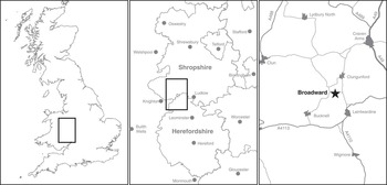
In 1867 a large hoard of metalwork was found during drainage and water management in a field known as ‘Lower Moor’ at Broadward Hall, on the Shropshire–Herefordshire border (fig 1). When the work was carried out, a concreted mass of metal was discovered, broken apart and found to comprise numerous bronze artefacts, including at least fifty-three spearheads, eleven fragments belonging to at least two leaf-shaped swords, five ferrules, two ‘bugle-shaped objects’, a tanged chisel, a chape and part of a tubular armlet or ring. The collection was subsequently dispersed: seventy-six implements were presented to the British Museum, but a box of finds kept at the Hall has since disappeared. It seems possible that a second group of objects was found in 1912–13, but nothing is known about them. Even so, it is likely that the hoard originally contained more than 100 objects.Footnote 14
The location of the Broadward hoard. Drawing: Sarah Lambert-Gates

There are four accounts of the original discovery, but they provide little information on the circumstances in which it was discovered and contradict one another at several points.Footnote 15 The first is the position of the findspot. One source refers to a ‘tumulus’ adjacent to the hoard site. It had been levelled some time before the metalwork was found. There were supposedly three such mounds at Broadward, and this particular example was located ‘in a nearly straight line with the other two’.Footnote 16 In fact, one of these features was probably of glacial origin, although enclosed by a shallow ditch, while another can be identified as a medieval motte. A line linking these features would extend well to the east of the findspot marked on the first edition Ordnance Survey map as ‘Bronze Spear Heads found 1867’. No trace of a third mound can be recognised today.
The earliest references to the hoard refer to the local microtopography. ‘The Lower Moor, in which the bronze was found, has been up to the time of the discovery one of the most wet … of the Valley of the Clun.’Footnote 17 ‘The cutting [that revealed the metalwork] was at the extreme edge of the swampy ground, where it rises rather abruptly to a higher level.’Footnote 18 The hoard was ‘on the very edge of [a] former morass’.Footnote 19 This description accords with the findspot recorded by the Ordnance Survey (so 39007625), but not with the site suggested by Burgess, Coombs and DaviesFootnote 20 who were influenced by Banks’s reference to a line of barrows further to the east (so 391762).
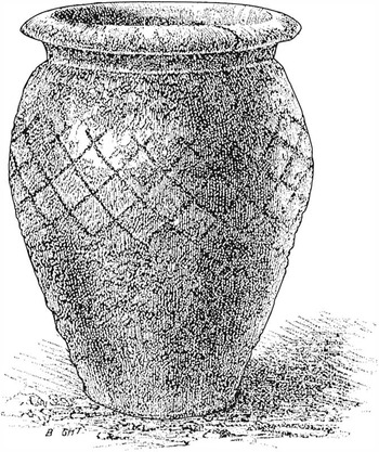
Nineteenth-century sources also shed light on the contents of the hoard. ‘Spear-heads and fragments of various patterns lay in a confused heap … Many were taken from the earth cemented together with the gravel into large solid lumps, the points laying in all directions.’Footnote 21 One author records that ‘large teeth … chiefly of a small equine species’ were found with the metalwork;Footnote 22 others say that ‘whole skulls of ox and horse … were taken up with the spears and other bones of the animals, as if the beasts of burden and their freight had been swamped in the bog’.Footnote 23 ‘Bones of oxen and pigs [were] found in the same locality.’Footnote 24 They were not confined to the position of the hoard, as Rocke and Barnwell record that ‘the number of animal bones dug up in every part of the field is remarkable’.Footnote 25 With the Late Bronze Age metalwork were ‘the imperfect remains of a small urn’.Footnote 26 It has been lost, but an illustration of the pot (fig 2) shows that it dates from the Roman period.
The Roman vessel discovered with the Late Bronze Age hoard. Drawing: after Barnwell Reference Barnwell1873

There is even more confusion about the circumstances of the original discovery. It is clear that the main group of metalwork was encountered in draining the bog. One account implies that the deposit was found in digging a land drain and that part of it might have remained intact. ‘The extent of the deposit was not ascertained, as it was not disturbed much beyond the width of the cutting, being an ordinary drain.’Footnote 27 Their description of the discovery also states that the ‘bronze was found at a depth of five or six feet below the surface’.Footnote 28 It was ‘in a deposit of clayey alluvium’.Footnote 29 The hoard was recovered under difficult conditions, as the excavation flooded once it reached the water table. That is why it was impossible to observe the relationship between the metalwork and the pot. In fact, the two statements contradict one another. The trenches dug to install the drains were considerably less than 5ft (c 1.52m) deep, but this was not true of the wells that they connected. They provided a source of fresh water that was pumped to Broadward Hall. The findspot recorded on the earliest Ordnance Survey map is shown as a spring. It was replaced in the same position by one of the wells.
These accounts raised the possibility that a Late Bronze Age hoard had been associated with a deposit of animal bones. More were found in draining other parts of the bog. The unusual size of the barbed spearheads encouraged the view that the hoard was a votive deposit. For both these reasons, Burgess, Coombs and Davies suggested that ‘excavation of the site … would be desirable’.Footnote 30 In the end that did not happen for nearly forty years.
CHRONOLOGY AND FIELD SURVEY
Two tasks were important from the outset: to establish the precise age of the metalwork and to elucidate the positions of nineteenth-century drains on the site.
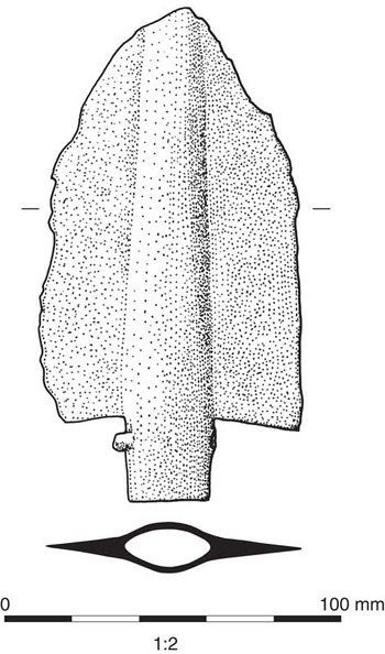
Two spearheads from the hoard held by the British Museum retained fragments of ash hafts within their sockets. Samples of the wood were submitted to the Scottish Universities Environmental Research Centre (SUERC) for radiocarbon dating. They returned the following dates:
2740±30 bp; 980–830 bc cal bc at 94.5 per cent confidence level (GU-26038)
Almost complete barbed spearhead (fig 3), acc. no. 1902, 0515,1Footnote 31
2760±30 bp; 940–820 bc cal bc at 94.5 per cent confidence level (GU-26039)
Fragmentary spearhead socket of the same type, acc. no. 1902, 0519,9Footnote 32
The better-preserved spearhead from the hoard whose shaft has been dated by radiocarbon. Drawing: Sarah Lambert-Gates after Burgess et al Reference Burgess, Coombs and Davies1972

These dates are consistent with the scheme put forward by Burgess, Coombs and Davies in 1972 and with subsequent research by Needham et al.Footnote 33 They place the hoard towards the end of the Late Bronze Age.
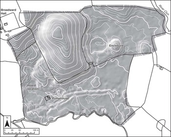
The most likely findspot for the hoard was examined by David Thornley and Darko Maricevic using ground-penetrating radar. They plotted the positions of the drains cut into the surface of the bog. Their work was supplemented by a topographic survey undertaken by Jo Dyson and undergraduate students of the University of Worcester, using a global positioning system (fig 4). Both investigations suggested that the most likely position for the hoard was on low-lying ground; this agrees with the position recorded by the Ordnance Survey. Several palaeochannels join this area from the north and may have led from other springs that were replaced by wells during the nineteenth century. Similar channels extend further to the east and originally would have discharged into a tributary of the Clun. The river itself is 600m east of the site.
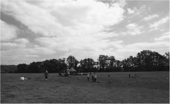
A general view of the area in which the Broadward hoard was discovered, showing a nineteenth-century pumping house in the background. Photograph: David Mullin

FIELDWORK IN 2010
The new project had two distinct foci: the likely findspot of the hoard and its surroundings, and a nearby earthwork enclosure. The work was directed by David Mullin, Jodie Lewis and Richard Bradley.
Excavations around the findspot of the hoard
Trench 1 focused on the area of the location of the hoard shown on the first edition Ordnance Survey map. The excavation was subsequently extended to the south and west, using a mini-digger with a toothless bucket. Rocke and Barnwell stated that the bronzes were found at the extreme edge of swampy ground where there was an abrupt rise in the ground.Footnote 34 For that reason the trench encompassed the higher and dryer land to the north and east and the low-lying boggy grassland to the south and west. Selected areas within this trench were selected for deeper excavation (figs 5 and 6). The individual contexts are discussed in greater detail in the project archive.
The microtopography of the areas studied, showing the location of the hoard and the position of the earthwork enclosure. Drawing: Sarah Lambert-Gates

The area excavated around the findspot of the hoard. The shaded area shows the disturbed area around the former spring, and the symbol marks the position of the pit. Drawing: Sarah Lambert-Gates

Disturbed deposits
A palaeochannel just over 6m wide ran across the middle of Trench 1 and cut into a series of alluvial clays as well as the natural bedrock. It was filled by loose greyish-black silt mixed with stones, burnt clay, charcoal and a few pieces of post-medieval tile and brick resulting from land reclamation. It also contained a fragment of a shale bracelet. A land drain had been dug through this deposit and contained a flint scraper. Other deposits of dumped material were found in the west of the excavated area where one of them contained part of an Early Bronze Age macehead. Perhaps these artefacts had originally been deposited in one of the springs or streams associated with the site, but if so they had been disturbed.
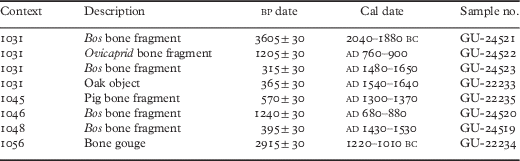
The main feature in Trench 1 was a brick well with a ceramic drain leading into it from the west (fig 7). To its south was a peaty deposit lapping against the natural rise in the ground level. Stones and pieces of bone were visible in the top of this deposit. Again, this material must have been disturbed as individual bones have dates of 2040–1880 bc, ad 760–900 and ad 1480–1650. Beside the well the peat was 0.4m thick, but it thinned towards the west where a single sherd of Late Bronze Age pottery was found. Closer to the well, it was partially overlain by stony clay covered by peat. An animal bone recovered from this deposit was dated to ad 680–880. Again, radiocarbon dates indicate that even the best-preserved animal bones must have been moved from their original contexts. The only features visible in the subsoil were a series of drains of different dates. As the geophysical survey had predicted, none lay ‘at a depth of 5 or 6 feet’.Footnote 35
The pit interpreted as the findspot of the hoard cut by the remains of a nineteenth-century well. Photograph: David Mullin

Intact deposits
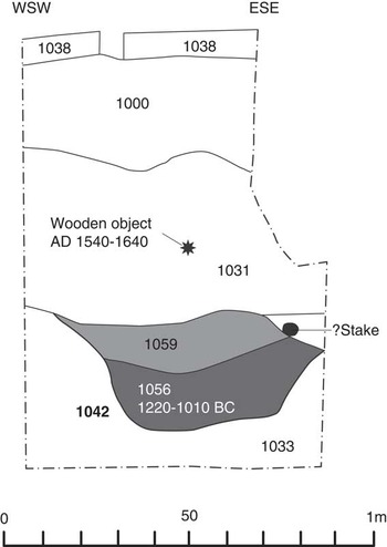
Beneath the peat was the edge of a pit, much of which had been destroyed by the well. The surviving part measured 800mm by 900mm and was 350mm deep (fig 8). It did not extend further north than the well, suggesting that it could never have been more than 2m long. The steep sides of the pit were dug into alluvial clay that underlay the peat, while its base cut into sandy gravel deposits. A spring was found to issue through the sandy gravel adjacent to the pit, causing the excavation to fill with water.
Profile of the pit interpreted as the context of the metalwork hoard. The drawing also indicates the position of the post-medieval wooden ‘knife’ or ‘dagger’. Drawing: Sarah Lambert-Gates

The pit contained two deposits: the lower one was up to 200mm thick and consisted of dark grey charcoal-rich silt with occasional fragments of quartz. The upper level was up to 150mm thick and consisted of yellow-brown stony clay. A bone gouge, dated to 1220–1010 bc, was discovered near the base of the primary fill, but there were no other finds from this context. Stones – one of them a piece of flaked quartzite – and smaller pieces of quartz lined the top and sides of the pit; others were distributed around its edge. Several small fragments of cremated bone were found beneath them. A thin layer of peat covered the stones to the south of the pit and contained a number of animal bones, one of which has been dated to ad 1430–1530.
The top of the pit was covered by 0.4m of peat (context 1031). Approximately 0.2m above it a wooden knife or dagger was recovered, lying horizontally in the peat. It has been dated to ad 1540–1640. Next to it, but dug from a higher level, was a small stake- or posthole. It post-dates the deposition of the blade, but its date and function are unknown.
A few other areas remained undisturbed. Excavation on the higher ground to the east of these deposits was uninformative, but a flint-core trimming flake was found on its surface. Five metres to the west of the pit there was a second peat-filled hollow. In this case the turf and topsoil lay directly over a deposit of peat, which was only 80mm thick. It contained no animal bones, but a flint burin was recovered. Beneath the peat the natural alluvial clay was excavated by machine to a depth of a metre.
Lastly, there was a palaeochannel 25m to the west of the pit. A deep machine trench was excavated, from which pollen samples were taken. On the edge of the channel animal bones were found a metre down in the peat. One of them returned a date of ad 1300–75.
Commentary
The fieldwork undertaken in 2010 sheds new light on accounts of the original discovery. The findspot recorded in the first edition Ordnance Survey map not only conforms to Victorian descriptions of the natural topography, it corresponds exactly to a peat-filled hollow containing animal bones and other artefacts. With the exception of a few examples from the western edge of the excavated area, they were confined to the immediate surroundings of the spring shown on the earliest Ordnance Survey map. The well – one of a series linked to a pumping house by a system of drains – had been excavated at precisely the same point. This area contained deposits of clay and peat, but they must have been disturbed by water issuing from the bedrock as the radiocarbon dates on the best-preserved animal bones showed no evidence of a coherent sequence.
The well cut the only subsoil feature that can be dated to the prehistoric period anywhere in the excavation: a pit containing a bone gouge with a radiocarbon date in the Middle to Late Bronze Age. Although only part of that pit survives, it seems to have been large enough to have held the concreted mass of artefacts found in 1867. This feature must have been dug on the edge of the spring, and that may account for the poor quality of the original record. The hole dug for the well soon flooded, so that it would have been impossible to tell how the metalwork was related to the Roman pot from the same site. It is surely no coincidence that Rocke and Barnwell stated that the hoard was found ‘five or six feet below the surface’.Footnote 36 That is not true of the Bronze Age pit, but it is the depth of the well, and the workmen may have emphasised the difficult conditions they experienced on the site.
With the exception of the bone gouge, a Late Bronze Age sherd and possibly a shale bracelet, the remaining artefacts found in 2010 relate to other phases in the history of the spring and its surroundings. The same is the case with all the animal bones submitted for radiocarbon dating. Their significance is considered in a later section of this paper.
Excavations at a nearby earthwork enclosure
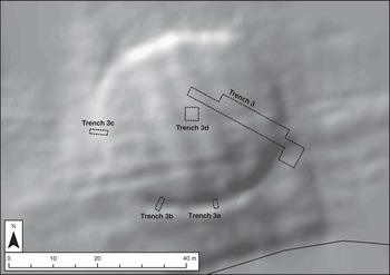
A roughly circular mound, 33–38m in diameter (fig 9), was found 300 metres to the north east. The two sites cannot be seen from one another and are separated by a spur of higher ground. Early maps depict a ‘tumulus’ in this location, but field observations suggested that it was of glacial origin.
The topography of the circular enclosure, showing traces of ridge-and-furrow and the extent of excavation. Drawing: Sarah Lambert-Gates

The summit of the mound was bounded by a ditch approximately 3m wide that was most apparent within the SSW–ESE quadrant, and only visible as a scarp around much of the northern perimeter. There is a break in the ditch just south of its easternmost point. It follows the break of slope. Also apparent are a series of broad parallel ridges oriented NNW–SSE and spaced roughly 7m apart, which may represent ridge-and-furrow.
The enclosure ditch was sectioned at three points. It was 2.3m wide and only 400mm deep and had a U-profile. To the south of the entrance, it contained two distinct fills: the upper a 250mm thick sandy-loam deposit with much gravel, and the lower 100mm thick orange-brown silt with a few charcoal flecks. Neither contained any finds. Elsewhere, the ditch contained a single fill: a sandy-loam deposit with gravel.
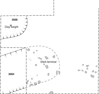
The south-eastern causeway or entrance was about 4m wide. A pit was discovered just inside the southern ditch terminal (context 3006). It extended beyond the excavated area and its exact shape and dimensions are unknown. The part that was excavated had gently sloping sides and a concave base and was 25cm deep. It contained a single fill of rounded gravel in a brown sandy-loam matrix. Within this was the lower part of a fired clay weight that had been placed upside down in the ground (fig 10).
Details of the ditch terminal (context 3004) and the partly excavated pit (context 3006). Drawing: Sarah Lambert-Gates

A machine trench measuring 17m by 4m was opened across the interior of the enclosure and extended across the entrance and the southern ditch terminal. This area was left open to weather, but no subsoil features were observed.
Commentary
The earthwork is surprisingly slight and its position is unusual, for the land around it floods, even today. At the same time, this work has shown that part of the interior that was excavated was free of any features or finds of artefacts. The only exception was a clay weight, which may be of Late Bronze Age date. This raises the possibility that the site played a specialised role and might have been in use at about the time when weapons were buried beside the nearby spring.
Radiocarbon dates on archaeological samples
A series of animal bones from the excavation were submitted for radiocarbon dating, together with two artefacts: the bone gouge found in the pit, and the wooden ‘dagger’ from the overlying peat (table 1). The bones that were sampled were in fresh condition and quite distinct from others that had been eroded. The object of the exercise was to compare their chronology with the dates of two spearheads from the original hoard. It was also to relate their chronology to the long sequence in an adjacent palaeochannel, which were sampled for pollen analysis. Sediment samples taken from its filling were also submitted for radiocarbon dating.
Radiocarbon dates for archaeological samples from Broadward
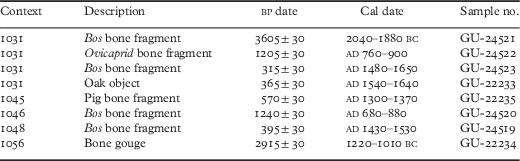
It was recognised from the outset that the bones could have moved vertically and horizontally as water issued from the spring. For that reason they were employed to assess the principal periods in which the site was in use and not to calibrate a clear stratigraphic sequence. The project achieved its main objective by showing that, in addition to the phases dated by the Roman pot and the Late Bronze Age hoard, there were peaks of activity in the Middle to Late Saxon phase, and again in the late medieval and early post-medieval period. There was also an Early Bronze Age radiocarbon date that agrees with the likely age of the macehead found in 2010.
POLLEN ANALYSIS
Nicholas Branch, Naomi Riddiford and Philip Stastney
The investigations at Broadward Hall presented an opportunity to reconstruct the environmental context of the archaeological findings and to enhance our knowledge of the Holocene vegetation history of Shropshire.Footnote 37 The geology of Broadward Hall is complex with the main north–south axis of the valley comprising alluvium, but with head deposits (clay, silt, sand and gravel) to the west of the site (probably within a minor tributary valley) and till and moraine (diamicton) occupying higher ground to the north and south.Footnote 38 The main archaeological site is located in a narrow east–west strip of alluvium, and the peat deposits encountered during the archaeological investigations, and discussed here, probably formed within, and on the (back-swamp) margins of, a former river channel.
Methods
The field investigations involved the excavation of a trench to the west of the main archaeological site, and within the suspected area of the palaeochannel, to recover column samples suitable for radiocarbon dating and pollen analysis. The physical properties, composition and humification of the sediments within the column samples were recorded using the Troels-Smith procedure.Footnote 39 Sub-samples were removed for organic matter determination using the loss-on-ignition method.Footnote 40 Pollen grains and spores were extracted following standard procedures, involving sub-sampling 1cm3 using a volumetric sampler, dispersal in 1 per cent Sodium pyrophosphate, sieving through 5µm and 150µm meshes to remove fine and coarse mineral and organic matter, removal of mineral matter using Sodium polytungstate (specific gravity of 2g/cm3), acetolysis and mounting in glycerol jelly.Footnote 41 Pollen grains and spores were identified using type collections and the following sources of keys and photographs: Moore, Webb and CollinsonFootnote 42 and Reille.Footnote 43 Plant nomenclature follows the Flora Europaea as summarised in Stace.Footnote 44
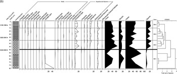
A total of 300 pollen grains (excluding aquatics and spores) were recorded for each sub-sample. The results are expressed as a percentage of total land pollen (trees, shrubs and herbs), and presented using TILIA2 software.Footnote 45 The pollen diagram has been divided into four Local Pollen Assemblage Zones (LPAZs, BH-1 to BH-4). Zonation of the pollen diagram into LPAZs was carried out using constrained cluster analysis within TILIA2 (calculated using Edwards and Cavalli-Sforza chord distance (square root transformation)), coupled with visual discrimination of the main changes in pollen stratigraphy.Footnote 46 Microscopic charred particles (>20µm) were counted during the pollen analysis and the results expressed as a percentage of total land pollen.Footnote 47
Radiocarbon determinations were made on humic acid extracted from peat sub-samples at key lithostratigraphic horizons through the sedimentary sequence. The radiocarbon determinations were calibrated using the maximum intercept method,Footnote 48 OxCal version 4.2Footnote 49 and the internationally agreed dataset for terrestrial samples from the northern hemisphere.Footnote 50 The full age range (rounded to ten years) is quoted as ‘cal yrs BP’. An age-depth model was created using OxCal version 4.2 with a P-sequence algorithm and k factor of 5.Footnote 51
Lithostratigraphy and radiocarbon dating
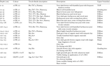
The basal mineral-rich fine-grained sediments (137–123cm; see table 2 and figs 11a and b) were deposited prior to 14,982–14, 145 cal yrs bp (13,032–12,195 cal yrs bc; table 3) during the Late Devensian Lateglacial. The presence of calcium carbonate in the sediments from 1370–1260mm suggests that they were at least partially derived from weathering and erosion of the nearby limestone bedrock (eg Much Wenlock Limestone Formation).Footnote 52 Organic sedimentation commenced at 14,982–14,145 cal yrs bp (1230mm; 13,032–12,195 cal yrs bc), and continued until after 2108–1899 cal yrs bp (158 cal yrs bc–ad 51; table 3). The organic sedimentary units mainly comprise herbaceous peat (sedge and grass) and wood peat, which indicate fen swamp and wooded fen carr, respectively. The only exception is a 20mm-thick unit of moss peat deposited from ~4173 to ~3996 cal yrs bp (350–330mm; ~2223 to ~2046 cal yrs bc), which suggests an increase in bog surface wetness at that time.
Pollen diagrams for the palaeochannel sampled at Broadward. Source: Nicholas Branch

Pollen diagrams for the palaeochannel sampled at Broadward. Source: Nicholas Branch

Broadward Hall: lithostratigraphy

Radiocarbon dates for the environmental samples

Pollen-stratigraphical analysis
The pollen analysis focused on the upper 800mm of the sedimentary sequence (80mm resolution) with a higher resolution study (40mm intervals) of the uppermost 500mm (~5300 to ~1200 cal yrs bp; ~3350 cal yrs bc to ad ~750), which spans the period of greatest archaeological interest.
Results
Local pollen assemblage zone BH-1 (800–490mm; ~12,252 to ~8960 cal yrs bp; ~10,302 to ~7010 cal yrs bc) spans the Late Devensian Lateglacial and Early Holocene. The pollen record is characterised by high percentage values of herbaceous taxa, notably Sinapis type (48 per cent at 800mm), Cyperaceae (50 per cent at 560mm) and Poaceae (31 per cent at 800mm), as well as Artemisia and Caryophyllaceae. Dominating the tree and shrub pollen taxa are Corylus type (26 per cent at 640mm), Tilia (16 per cent at 640mm) and Alnus (12 per cent at 640mm), as well as Betula, Quercus and Ulmus. Aquatic and spore taxa are poorly represented, but include Sparganium type, Dryopteris type and Sphagnum.
Local pollen assemblage zone BH-2 (480–350mm; ~5321 to ~4262 cal yrs bp; ~3371 to ~2312 cal yrs bc) spans part of the Middle Holocene; the abrupt changes in pollen percentages and taxa indicate a major hiatus between zones BH-1 and BH-2, possibly lasting for ~3500 years. The record is characterised by high percentages of tree and shrub taxa, notably Alnus (44 per cent at 440mm), Quercus (14 per cent at 440mm) and Corylus type (15 per cent at 400mm), as well as Tilia and Calluna. Poaceae (22 per cent at 360mm), Apiaceae (7 per cent at 400mm) and Filipendula (7 per cent at 400mm) dominate the herbaceous taxa. Aquatic and spore taxa include Dryopteris type (22 per cent at 440mm), Pteridium (4 per cent at 360mm) and Sphagnum (7 per cent at 360mm). Microscopic charred particles are present at 440mm (1 per cent).
Local pollen assemblage zone BH-3 (350–150mm; ~4262 to ~2500 cal yrs bp; ~2312 to ~550 cal yrs bc) spans the latter part of the Middle Holocene and the transition to the Late Holocene. The record indicates a reduction in tree pollen percentages by comparison to LPAZ BH-2, and a modest rise in shrub taxa, notably Alnus (40 per cent at 280mm), Quercus (14 per cent at 210mm), Corylus type (19 per cent at 280mm) and Calluna (4 per cent at 210mm), as well as Betula and Pinus. Herb taxa are dominated by Poaceae (31 per cent at 240mm), Cyperaceae (11 per cent at 160mm), Filipendula (6 per cent at 240mm), Galium type (6 per cent at 240mm), Lactuceae (2 per cent at 240mm), Plantago lanceolata (2 per cent at 320mm), Poaceae >40 microns (2 per cent at 320mm) and Ranunculus type (3 per cent at 240mm). Aquatic and spore taxa include Dryopteris type (19 per cent at 210mm), Pteridium (2 per cent at 280mm) and Sphagnum (6 per cent at 280mm).
Local pollen assemblage zone BH-4 (150–0mm; ~2500 cal yrs bp/~550 cal yrs bc onwards) is dominated by herbaceous taxa, notably Poaceae (20 per cent at 40mm), Cyperaceae (18 per cent at 80mm), Filipendula (4 per cent at 80mm), Cirsium type (3 per cent at 40mm), Lactuceae (3 per cent at 40mm) and Plantago lanceolata (3 per cent at 80mm), as well as Poaceae >40 microns (1 per cent at 120mm), Potentilla type (2 per cent at 120mm), Rumex (2 per cent at 80mm) and Succisa (3 per cent at 120mm). Tree and shrub taxa include Alnus (24 per cent at 120mm), Quercus (10 per cent at 120mm), Tilia (3 per cent at 120mm), Ulmus (2 per cent at 80mm), Corylus type (13 per cent at 40mm) and Calluna (3 per cent at 120mm). Aquatic and spore taxa include Dryopteris type (15 per cent at 120mm), Pteridium (2 per cent at 40mm) and Sphagnum (11 per cent at 40mm). Microscopic charred particles are present at 120mm (1 per cent) and 40mm (3 per cent).
Interpretation
During LPAZ BH-1 (~12,252 to ~8960 cal yrs bp; ~10,302 to ~7010 cal yrs bc), the pollen record indicates that the local wetland comprised vegetation typical of a fen with Cyperaceae (sedge family), Poaceae (grass family), Sparganium (bur-reed) and Sphagnum moss, together with Alnus (alder) and Salix (willow) carr woodland. The dryland vegetation was initially dominated by herbaceous taxa, notably Sinapis (Brassicaceae/mustard family) and Artemisia (eg glacier wormwood), indicating the presence of short turf grassland and tall herb plant communities. These are consistent with the Late Devensian Lateglacial age for the lower part of the sedimentary sequence (~1370–690mm; ~15,000 to 11,500 cal yrs bp), and the presence of cold, harsh climatic conditions (eg tundra and semi-desert). This record is also consistent with pollen data from the UK spanning the Late Devensian Lateglacial including nearby Crose Mere.Footnote 53
Mixed deciduous woodland and shrubland comprising Corylus (hazel) and Tilia (lime), with lesser amounts of Quercus (oak), Ulmus (elm) and Betula (birch), succeeded the herb-dominated plant communities, which is broadly consistent with other pollen records for the Early Holocene in Shropshire.Footnote 54 The possible dominance of Tilia within the woodland cover during the Early Holocene has been suggested by several of these studies despite the low percentages often recorded on account of its poor pollen dispersal.Footnote 55
The transition to LPAZ BH-2 (~5321 to ~4262 cal yrs bp; ~3371 to ~2312 cal yrs bc) was marked by a major hiatus in the sedimentary sequence, possibly lasting ~3500 years. The renewal of peat formation and presence of Alnus, Polypodium (polypody fern), Sphagnum and a range of herbaceous taxa is consistent with the presence of fen carr woodland. The surrounding dryland comprised mixed deciduous woodland and shrubland dominated by Corylus and Quercus, suggesting the presence of open (‘parkland’) rather than closed woodland. Supporting this interpretation is the presence of dwarf shrubland (heathland), grassland and disturbed ground comprising Calluna (heather), Apiaceae (carrot family) and Plantago (eg common plantain). The declining Tilia pollen values are consistent with the age proposed for LPAZ BH-2, and suggests that the evidence from Broadward Hall for a decline in lime woodland may be correlated with the classic ‘Tilia decline’ of north-west Europe during the Late Neolithic and Bronze Age from ~5000 to ~3000 cal yrs bp (~3050 to ~1050 cal yrs bc).Footnote 56 Supporting this interpretation are the low values of Ulmus pollen, indicating that LPAZ BH-2 post-dates the classic ‘Ulmus decline’ of north-west Europe during the Neolithic from ~6347 to ~5281 cal yrs bp (~4397 to ~3331 cal yrs bc).Footnote 57
From ~4262 to ~2500 cal yrs bp (~2312 to ~550 cal yrs bc), LPAZ BH-3 indicates a local wetland dominated by fen carr woodland, but with a slight reduction in the proportion of Alnus and a corresponding increase in Poaceae, Cyperaceae and especially Sphagnum moss. This suggests an increase in bog surface wetness, which is confirmed by the formation of moss peat from ~4173 to ~3996 cal yrs bp (~2223 to ~2046 cal yrs bc). The reason for this hydrological change remains unclear, but given the evidence presented below for localised human activity, the increase in wetness may have been initiated by increased overland flow due to woodland clearance. The dryland vegetation shows a marked reduction in mixed deciduous woodland cover, especially Tilia. This coincides with the first clear evidence for human activity characterised by the presence of cereal pollen (undifferentiated), suggesting localised cultivation. The increase in herbaceous taxa is consistent with this signature for human impact on the environment; especially those taxa associated with disturbance and cultivated ground such as Plantago lanceolata (ribwort plantain). The Late Bronze Age spearheads from Broadward Hall, which have been radiocarbon dated to 2921–2765 cal yrs bp (980–830 bc cal yrs bc; 2740±30 bp) and 2943–2780 cal yrs bp (940–820 bc cal yrs bc; 2760±30 bp), may be correlated with the upper part of LPAZ BH-3 (~210–180mm). Therefore, we can state with increased certainty that the environmental changes recorded during this zone correspond to localised human activities.
Finally, LPAZ BH-4 (~2500 cal yrs bp/~550 cal yrs bc onwards) indicates a significant increase in herbaceous and spore taxa associated with both dryland and wetland vegetation, and an overall reduction in tree and shrub taxa. The wetland comprised Poaceae, Cyperaceae, Sphagnum moss, Succisa (devil’s bit scabious) and Potentilla (tormentil), but with lesser amounts of Alnus in comparison with previous zones. This suggests a retrogressive development to grass-, sedge- and moss-dominated fen swamp. On the dryland, there is herbaceous taxa increase in diversity, notably Poaceae, Anthemis (chamomile), Artemisia (mugwort), Cirsium (thistle), Lactuceae (eg dandelion), Plantago lanceolata and Rumex (docks and sorrels). These taxa indicate open conditions and, together with the presence of cereal pollen and microscopic charred particles, provide further evidence for human impact on the local environment characterised by clearance, cultivation and the possibility of deliberate biomass burning. The transition to more open conditions during zones BH-3 and BH-4 (from ~4262 cal yrs bp/~2312 cal yrs bc onwards) seems to be consistent with pollen data from other Shropshire sites,Footnote 58 and therefore supports the interpretation from Broadward Hall of increasing human impact from the Bronze Age onwards.
Discussion of the environmental history
The radiocarbon-dated sedimentary sequence from Broadward Hall provides a record of environmental change from at least 14,982–14,145 cal yrs bp, unmatched in the region for its long chronology. Further pollen-stratigraphical analysis of the lowermost part of the sequence (1370–500mm) will provide an important contribution to our understanding of the Late Devensian and Early Holocene vegetation history of Shropshire. The preliminary results reported here for the period spanning ~12,252 to ~8960 cal yrs bp (LPAZ BH-1; ~10,302 to ~7010 cal yrs bc) are broadly consistent with other sites in western parts of the UK.Footnote 59 For example, at Crose Mere, the record of declining Betula woodland recorded after 12,601–11,351 cal yrs bp (10,310±210 bp; ~10,651–9401 cal yrs bc), and the maximum expansion of Corylus shrubland attained at 10,266–9310 cal yrs bp (8730±200 bp; 8316–7360 cal yrs bc),Footnote 60 is compatible with the results obtained from Broadward Hall. The higher than expected proportion of Tilia woodland recorded during LPAZ BH-1 is less consistent with the majority of other sites, and may be attributed to the small, localised depositional environment and close proximity of nutrient-rich, freely draining soils suitable for Tilia growth.Footnote 61
The sustained decline of Tilia woodland recorded from ~5321 cal yrs bp (LPAZ BH-2; ~3371 cal yrs bc) at Broadward Hall is consistent with the national picture for the classic ‘lime decline’ from 5000–3000 cal yrs bp.Footnote 62 Given that the decline occurred during a period of sustained peat formation, the cause may be equated with paludification Type I of Grant, Waller and Groves.Footnote 63 It is highly likely, however, that the further decline in Tilia from ~3900 cal yrs bp (LPAZ BH-3; ~1950 cal yrs bc) was on account of the impact of human activities and, in particular, clearance of woodland for cereal cultivation. This suggestion is consistent with the findings of Grant, Waller and Groves,Footnote 64 who indicate that 56 per cent of the 164 Tilia declines recorded in the UK can be attributed to human activity.Footnote 65 At Crose Mere, for example, the lime decline was recorded at 4421–3720 cal yrs bp (3714±129 bp; 2471–1770 cal yrs bc) during a period of sustained human activity, including cereal cultivation, which resulted in the expansion of grassland.Footnote 66 At Fenemere, localised clearance of lime, oak and elm from 3566–3266 cal yrs bp (1616–1316 cal yrs bc) corresponds to an increase in herbaceous and fern taxa (eg bracken, ribwort plantain, docks and sorrels) with accompanying evidence for cereal cultivation and pastoralism.Footnote 67 These data are also broadly consistent with the record from Whixall Moss where the Tilia decline has been recorded at 3822–3169 cal yrs bp (1872–1219 cal yrs bc).Footnote 68
At several Shropshire sites, including Broadward Hall, this period also records a sustained increase of plant taxa indicating heathland, notably Calluna and Erica (eg Fenemere).Footnote 69 This suggests an accompanying change in soil status on the freely draining substrates (eg head deposits and diamicton), which was probably associated with a reduction of woodland cover on brown earth soils. Although the cause of heathland formation during the Middle Holocene may be due to natural processes of soil degradation and climate change to wetter conditions, at many sites palaeoecological and archaeological evidence for Bronze Age human activities clearly indicates that anthropogenic disturbance of the environment was a probable cause.Footnote 70
Deposition of the spearheads at Broadward Hall therefore occurred during a sustained period of human activity that commenced prior to ~2900–2700 cal yrs bp (~950–750 cal yrs bc) and continued throughout the main period of archaeological interest. Similar evidence for woodland clearance and cereal cultivation, and an expansion of grassland, during the later Bronze Age has been recorded at several sites (eg Fenemere) and was accompanied by localised increases in bog surface wetness and changes in wetland vegetation, which is consistent with those recorded at Broadward Hall. According to Twigger and Haslam,
The extent of woodland clearance in north Shropshire appears to have varied between c 800 [~2900 cal yrs bp] and c 600 [~2750 cal yrs bp] bc … Averaged over a wide area of the lowlands, possibly a third of the tree cover was removed with up to three quarters of the woodland cleared in favoured localities … such as the drier, well-drained brown earth soils on the sand and gravel deposits. Footnote 71
Whether a similar interpretation can be applied to south Shropshire remains uncertain without further pollen studies. However, the results from Broadward Hall seemingly provide a record for human activity and environmental change during the Bronze Age that is consistent with the findings from the northern part of the county.
FAUNAL REMAINS
Aleks Pluskowski
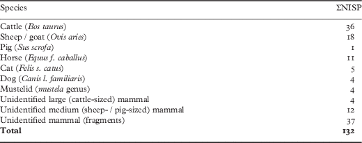
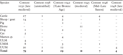
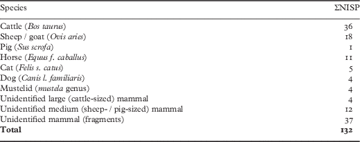
A total of 132 bones were recorded, of which seventy-nine were identifiable to species (table 4). The assemblage was generally in poor condition with the majority of bones eroded, weathered and fragmented. Given the small number of fragments divided across six contexts, all quantification was based on NISP (Number of Identified Specimens Present) rather than MNI (Minimum Number of Individuals). They came from a number of separate contexts, details of which will be provided in the project archive.Footnote 72 Their dates are suggested on the basis of radiocarbon dates. Where more than one determination comes from the same context, the later date is used.
Species count by Number of Identified Species Present
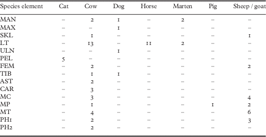
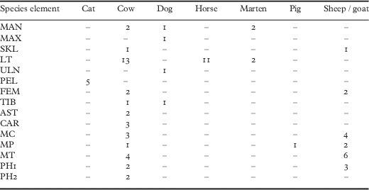
Two tentative conclusions can be drawn from the element distribution of the individual species (table 5). First, that some fragments are very likely to be derived from the same animal (for instance, the cat from context 1031 associated with a late medieval carbon date, the mustelid from context 1042, which came from a deposit with another medieval date, and the horse from context 1045). Second, in the case of the cattle remains, elements from across the cranial and post-cranial skeleton are represented, particularly in context 1031 where the largest number of cattle bones were identified (N=27).
The distribution of elements for individual species: MAN=mandible; MAX=maxilla; SKL=skull; LT=loose tooth; ULN=ulna; PEL=pelvis; FEM=femur; TIB=tibia; AST=astragalus; CAR=carpal; MC=metacarpal; MP=metapodial; MT=metatarsal; PH1=first phalanx; PH2=second phalanx
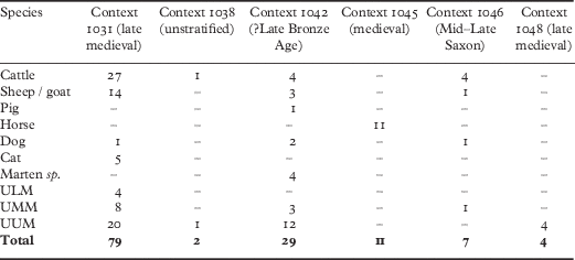
The largest assemblage was represented by context 1031, where seventy-nine bone fragments were recorded, followed by context 1042 where twenty-nine fragments were recorded (table 6). Context 1045 consisted of a single, fragmented left mandible from a horse. This deposit was probably late medieval.
The distribution of species by context: ULM=unidentified large mammal; UMM=unidentified medium mammal; UUM=unidentified mammal
Osteometrics
On account of the poor preservation of the assemblage, only a limited number of measurements could be taken (table 7).
Measurements for the three cattle bones from contexts 1046 and 1031: Bp=breadth of proximal; Bd=breadth of distal; GL=greatest length (of a complete bone)

Cattle
The largest quantity of cattle bones (N=27) was derived from context 1031, dated to the late medieval period. These bones, recovered from a single fill, represented a range of cranial and post-cranial elements, probably linked to food waste in the absence of evidence for manufacturing marks. Lower limb bones are particularly represented, and in one case may derive from an associated bone group (a partially articulated foot). Epiphyseal fusion indicated that the majority of elements derived from mature individuals, at least two years old on the basis of the unfused metacarpals and tibia fragments.Footnote 73 The unfused proximal end of a second phalanx indicated the presence of a neo-natal animal.
Sheep / goat
Fourteen sheep / goat bones were recovered from context 1031, dated to the late medieval period. They, too, are represented largely by lower limb bones. The distal ends of four metacarpals were unfused, indicating the presence of animals younger than 18–24 months, while two unfused first phalanges point to individuals no older than 16 months.
Pig
A single pig bone consisted of a badly preserved metapodial from a possible Late Bronze Age context (1042).
Horse
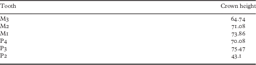
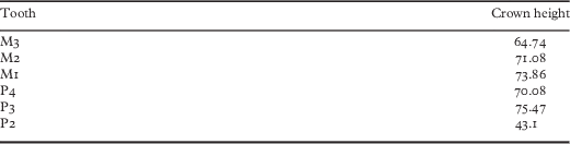
Eleven horse bone fragments were recovered from context 1045 (dated to the medieval period), largely derived from a single left mandible, which was fragmented and in very poor condition. The extant teeth (five incisors, three molars and three premolars) were loose and it was possible to measure crown heights (table 8). On this basis, it was possible tentatively to estimate the age of the animal using Levine’s method,Footnote 74 resulting in a median score of six years (range five–seven).
The measurements of three horse molars and three horse premolars from context 1045
Other mammals
Five domestic cat bones from a late medieval context represent a fragmented pelvis, while four dog bones from late medieval and possible Late Bronze Age contexts were derived from disparate cranial and limb bones. This included a fragment of maxilla from context 1042 with a heavily worn M1 and M2. The dog tibia fragment from context 1046 contained pathological osteophytes on the proximal end of the bone, which had linked the condyles. This is typically indicative of osteoarthritis. Four fragments from a mustelid jaw (context 1042; Late Bronze Age) could not be positively identified to species, but were larger than a stoat and close to the size of a polecat or marten.
Discussion
This very small assemblage of bones from six discrete contexts is dominated by domesticates. No cut marks were observed on any of the bones and it is difficult to link these bones to specific forms of human activity, other than depositional. The presence of a partial horse mandible may indicate that cranial or carcass parts were deposited here, which is more evident with the representations of different body parts among the cattle, and the character of the bone fragments from the main domesticates is typical of rubbish deposits, pit and trench fills from various periods. The deposits may have been related to what can be broadly and generically described as ‘ritual’ activity associated with the spring. Domestic animals, not only horses and dogs, but also cattle and sheep, are widely associated with ritual killing and depositional procedures across northern Europe.Footnote 75
CREMATED BONE
Fiona Shapland
Cremated bone was recovered from three contexts at Broadward: 1031 (one fragment), 1046 (two fragments) and 1048 (one fragment). The cremated bone was macroscopically examined in the laboratory. Bone colour and condition was recorded for the information this can provide on the cremation process.Footnote 76 All bone fragments identifiable to an area of the skeleton or specific bone were separated out for analysis. They may be human or animal. The largest (from context 1031) measures 14mm by 7mm, and the remaining three fragments all measure less than 7mm by 5mm. None is identifiable to a specific skeletal element. All four are white / grey in colour, indicating that a temperature of over 900°C was maintained during the cremation process.Footnote 77
WOODEN KNIFE OR DAGGER
Steven Allen and Richard Bradley
A piece of worked oak from the peat overlying the Bronze Age pit was submitted to the York Archaeological Trust for conservation (fig 12). It is dated to 365±30 bp, which calibrates to ad 1540–1640 (GU-22233). It consists of a section of a radially faced lath, one end of which is shaped to a crude point, and resembles a roughly carved knife or dagger. The hilt is slightly worn, as if it once had a handle. Because it is comparatively crude, it would not be appropriate to compare it with metal artefacts of similar date.
The wooden ‘knife’ or ‘dagger’ retrieved from the spring deposit. Drawing: Sarah Lambert-Gates

MACEHEAD
Fiona Roe
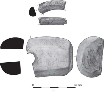
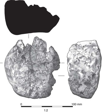
Part of a macehead was found in a nineteenth-century deposit consisting of dumping into the fill of a stream (fig 13). The surviving end is flattened, while the macehead is broken across the shafthole and was also split in two lengthwise so that the fragment now measures just 52.5×45×30mm, with a weight of 117g. It is light brown in colour and the surface is smooth, but with a series of small cracks that are suggestive of burning; this may also have caused further damage at the more complete end. The shafthole is basically cylindrical and smoothly made, but bored at an angle. The macehead was not thin sectioned, but appears to be made from a quartzite pebble and this may account for the slightly uneven shape, with one side more curved than the other, while the hardness of the material would have caused some difficulty in boring the hole, so that it is not quite central. Quartzite was used to make 20 per cent of maceheads for which petrological identifications are available, so the choice of material is not unusual.
The shale bracelet (upper) and the stone macehead (lower) from deposits around the spring disturbed during nineteenth-century land reclamation. Drawing: Sarah Lambert-Gates

The flattened end is a decisive feature, since it differs from the rounded ends of Neolithic Ovoid, Pestle and Cushion maceheadsFootnote 78 and this detail suggests that the fragment belongs within a smaller number of Early Bronze Age maceheads with central, straight-bored shaftholes.Footnote 79 The most recent review of these later examples commented on the disparate forms that appear after about 2000 cal bc.Footnote 80 It seems most likely that the fragment from Broadward could belong in the Largs group,Footnote 81 which encompasses a dozen or so maceheads with flattened ends and is named after a Scottish find associated with a tripartite cinerary urn. This, however, has incised decoration around the shafthole, reminiscent of the grooved ornament found on some later Scottish battle-axes. A better comparison can be made with the macehead found in barrow C39 at Towthorpe, Yorkshire East Riding.Footnote 82 This macehead is somewhat problematical, however, since Mortimer does not state that it was restored at one end, and the plaster remodelling is barely shown in his illustration, although it may approximate to the outline he must originally have seen in the ground. This macehead was found with an inhumation burial and associated with a flint knife and a bronze dagger that is related in form to one of those from the Bush Barrow assemblage.Footnote 83
It appears more usual for Largs group maceheads, when associated, to be found with cremation burials. Three Scottish examples are known, but these maceheads are all larger and relatively broader than the Broadward specimen, as is the example found in a cist at Cleughead Farm, Glenbervie, which has been dated to 1730–1540 cal bc,Footnote 84 placing it within Needham’s period 4.Footnote 85 Another of these maceheads occurred with a cremation in a Cordoned Urn at Cambusbarrow,Footnote 86 while at Larg a number of cinerary urns containing cremations were found, although the macehead and further cinerary urn sherds were recovered separately. Other centrally bored maceheads of varying forms have also been recorded in association with cremations.Footnote 87 If the find from Broadward belonged with another such cremation burial, the cremation process could account for the traces of burning that have been noted above.
It is only possible to suggest a wide dating range for Largs group maceheads, which are likely to fall within Needham’s Early Bronze Age periods 3 and 4 between around 1950 and 1550 / 1500 cal bcFootnote 88 and so some thousand years later than the main series of maceheads. If the comparison with the macehead found at Towthorpe holds good, the Broadward macehead could also be approximately contemporary with the grave group from West Overton G.1, which included a bronze axe of Willerby type comparable with that from the Bush Barrow assemblage.Footnote 89 The West Overton grave group is now dated to 2020–1770 cal bc,Footnote 90 providing a link with period 3 or slightly earlier than that, while other Scottish Largs group maceheads could belong within period 4, as does the one from Cleughead Farm. At Broadward the macehead cannot be contemporary with the hoard of bronze objects, which must be later. Maceheads with centrally positioned shaftholes do not generally occur within Wessex itself,Footnote 91 the Bush Barrow example being a somewhat anomalous find, as is that from Clandon, Dorset,Footnote 92 so that a burial with one of these uncommon maceheads on the Shropshire / Herefordshire border would not be out of place.
BONE GOUGE
Richard Bradley
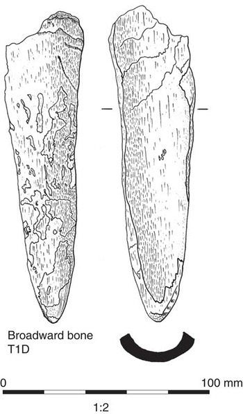
In the lower filling of the pit cut by the well was a slightly eroded gouge made from a long bone identified as bos. It provided a radiocarbon date of 1220–1010 bc (fig 14). This kind of artefact is not particularly diagnostic but appears at Middle and Late Bronze Age settlements where bone is preserved.
The bone gouge from the Bronze Age pit on the edge of the spring deposit. Drawing: Sarah Lambert-Gates

WORKED FLINT AND OTHER STONE
David Mullin
Only three pieces of worked flint were recovered from the excavation: a thumbnail scraper on good-quality dark brown flint from context 1003, a microburin from context 1017 and a core trimming flake from context 1021.
A large flake of chipped quartzite measuring 120mm by 90mm with scars along one edge was recovered from Trench 1, context 1033, a deposit of alluvial clay underlying a peat deposit. This may have been used as a rather crude chopping or scraping implement. BarfieldFootnote 93 has identified similar expedient use of raw materials to manufacture crude tools at other sites in Shropshire, such as Meol Brace where fine-grained meta-siltstone and altered alkali dolerite, probably local glacial erratics, were used to produce flake tools.
SHALE BRACELET
Richard Bradley
A single piece of worked shale was recovered from a nineteenth-century deposit. It is semicircular in cross section and is polished on the exterior but not the interior (see fig 13). It has an estimated diameter of 80mm. It is difficult to date such a small fragment but its cross section is a little unusual and is not represented among the artefacts from Iron Age and Roman shale-working sites in Purbeck. On the other hand, a bracelet of similar form and size comes from a Late Bronze Age context at Eldon’s Seat in the same region.Footnote 94
POTTERY
David Mullin
A single sherd of pottery (33g) was recovered beside the pit. It is a body sherd from a large vessel, although it is not possible to be certain of the diameter or form. The fabric contains frequent rock inclusions up to 4mm in diameter and the external face appears to have been smoothed. Such fabrics are fairly well known in the Welsh Marches from sites such as BromfieldFootnote 95 and Beeston CastleFootnote 96 and span the Middle to Late Bronze Age.
CLAY WEIGHT
Richard Bradley
The only find from the excavation of the enclosure (Trench 3) was a broken clay weight from context 3007. It had a flat base and a circular cross section (fig 15). It was extremely friable and had been placed upside down in the ground. The surviving fragment lacked a hole for suspension, showing that it did not form part of a cylindrical loom weight. On the other hand, Late Bronze Age and Iron Age examples from the Marches are usually perforated horizontally towards the top. This fragmentary artefact was probably of that type. It is significantly larger than intact examples from Iron Age contexts at the Breiddin, Croft Ambrey and Sutton Walls, and is much more like the clay weights from a Late Bronze Age context at Beeston Castle. In a recent paper, Best and Woodward suggest that such artefacts may not have been associated with weaving and might have functioned as kiln furniture; there are examples with traces of burning towards the base.Footnote 97 That might explain why only part of this object has survived.
The clay weight from the pit in the entrance to the circular enclosure. Drawing: Sarah Lambert-Gates

THE IMPLICATIONS OF THE PROJECT
From the outset the project had two aims. The first was to relocate the findspot of the Broadward Late Bronze Age hoard and to investigate its setting in the ancient landscape. The second was to characterise a circular enclosure located not far from the bog in which the metalwork was discovered. The project did not involve a new analysis of the original artefacts, but wood samples from two of the spearheads were dated by radiocarbon.
The first aim was achieved, albeit with some difficulty. It became clear that numerous wells and land drains were excavated during the nineteenth century, making it particularly hard to establish which of these structures was associated with the original discovery of the hoard. In the event only one convincing candidate was identified. It was precisely where the discovery had been shown on the earliest Ordnance Survey map. Not only was the position of the pit consistent with the information provided in the first accounts of the site, it contained a bone gouge which dates from the Middle to Late Bronze Age.
The introduction to this paper posed some specific questions that might be answered through the excavation of a prehistoric spring. It is worth returning to them now.
Did the spring already exist during the prehistoric period?
This is the implication of the environmental evidence from Broadward. Although this part of the bog had been disturbed in the nineteenth century, it is clear that the pit was located right beside a spring that was replaced by one of the wells excavated in 1867. Despite the damage caused by Victorian land drainage, palaeochannels were identified only a few metres from the findspot. One of them produced environmental evidence that the immediate area had been a wetland since the early post-glacial period, and there seems no reason to doubt that there had been a spring there throughout that time. This is also indicated by the character of the surviving deposits and the unusual position of the findspot at the base of a natural bluff on the junction between two geological deposits.
Could it be demonstrated that the deposits of artefacts focused on that spring?
To a large extent this was shown to be the case by the fieldwork carried out in 2010. Apart from the hoard itself, the material of prehistoric date consists of a stone macehead, a bone gouge, a few fragments of worked stone, a single sherd and part of a shale bracelet, most probably all of Bronze Age date. They were scattered throughout the disturbed contexts around the edge of the spring and were not found in other parts of the excavation, including a second area of waterlogged deposits.
What was the full range of artefacts associated with the spring?
The project shed new light on the character of the hoard discovered in 1867. Not only had it been buried beside an active spring, it was probably also associated with a number of items that would not have been collected, or even recognised, in the nineteenth century. That cannot be proved as no metalwork was found in 2010, and the case depends on the position of the pit in relation to the earliest map showing the position of the hoard. The surviving part of the pit in which the metalwork appears to have been deposited included a bone gouge, which may have pre-dated the bronze artefacts by a century or more, a few tiny fragments of bone, which had been burnt to a very high temperature, flaked stone and fragments of quartz. Unfortunately, it was impossible to establish whether the bone came from a human cremation, although ‘token’ deposits of this kind are common on Late Bronze Age sites.Footnote 98 Such discoveries recall antiquarian accounts of metalwork deposits associated with finds of human bone, but they provide too little detail to allow a closer comparison.Footnote 99
An early account of the Broadward hoard suggests that the metalwork was also found with ‘whole skulls of ox and horse’.Footnote 100 Such an association is entirely possible, but the only horse bones found in the recent excavation come from the late medieval period, and none of those belonging to other species have radiocarbon dates in the Late Bronze Age. Of course, only the best-preserved bones were selected for dating, and the possibility remains that other phases were not represented.
Could the sediments associated with the spring provide a dated environmental evidence?
Would it be possible to show whether the metalwork hoard was isolated, or was it located in a settled landscape?
Pollen analysis showed that the area had been farmed during the phase in which the metalwork was deposited. In fact, the earliest evidence of agriculture at Broadward is assigned to the Early Bronze Age. Although a settlement must have existed somewhere in the vicinity its location remains unknown and the project reported here did not identify any other features close to the spring itself. Only one Late Bronze Age sherd was found beside this feature.
On the other hand, there was a circular enclosure located not far away on the summit of a glacial mound. It was separated from the hoard site by an area of higher ground, but the earthwork shares the distinctive feature that the surrounding area is often flooded. Despite a campaign of land drainage that began a century and a half ago, there are times when the site resembles an island. The excavation showed that the enclosure was relatively insubstantial, but had a precisely circular outline: a feature that is quite common among the later prehistoric earthworks of the Welsh Marches.Footnote 101 Excavation within the interior did not produce any finds, and only one artefact was discovered in the entrance. It was a clay weight that had been deposited in a pit. It cannot be dated as accurately as the deposit of metalwork, but, like the hoard, should date from the Late Bronze Age. Its siting is so distinctive that the enclosure is unlikely to have been an ordinary settlement.
The new fieldwork suggested that the spring was a focus for human activity over a longer period than had been suspected. The worked flints found close to the spring may relate to hunting or grazing in a productive environment, but the other finds raise problems. The first is the Early Bronze Age macehead found on the edge of the spring in a nineteenth-century context. Although it might have come from a barrow levelled in the nineteenth century, accounts of the site are confusing. Unlike most of the finds from prehistoric graves, this object seems to have been deliberately broken and only half of it is represented. For that reason it is tempting to suggest that it was more directly associated with the deposits in the spring. They included an animal bone with a radiocarbon date in the same period. It was at about this time that the surrounding area was first farmed.
The Late Bronze Age hoard itself typifies a wider pattern. Like other examples from the English / Welsh border, it was associated with a tributary of a larger river and not with the principal watercourse.Footnote 102 Its location in an area of boggy ground is one of the characteristics of finds of metalwork in this region. Recent studies of the siting of hoards in Wales,Footnote 103 south-east England and the Fenlands illustrate the same connection between streams, springs and deposits of Bronze Age metalwork,Footnote 104 even when the artefacts themselves were buried in dry ground. They also show that hoards could have been outside, but close to, settlements. That would be consistent with the environmental evidence from this project.
Although artefacts of different dates have been recovered from rivers, there is little evidence from the excavation of springs in Britain. The one exception comes from current work at Amesbury in Wiltshire, where excavation of a similar deposit has found not only Mesolithic artefacts but also a dagger made from the tip of a bronze rapier, a Middle Bronze Age chisel and a Roman lead curse tablet. An Anglo-Saxon disc brooch was discovered in a similar context nearby.Footnote 105
LATER ACTIVITY AT THE BROADWARD SPRING
Later activity on the Shropshire site poses more difficult problems. They are discussed only briefly as they were not the focus of this project. Some confusion attaches to a complete Roman pot discovered with the Late Bronze Age hoard. Although it no longer survives, it was illustrated in 1873 and can be dated to the second or third century ad. There is no evidence of other activity in the vicinity, although there was a series of forts at Leintwardine.Footnote 106 Again, it seems possible that the vessel was deposited in the spring as an offering, but of course that cannot be proved.Footnote 107 It could have been contemporary with the part of a shale bracelet found in the excavation, but this artefact is more likely to date from the Late Bronze Age.
Radiocarbon dating suggests that deposits of animal bones accumulated around the spring during two main periods: between about ad 680 and 900, and again between ad 1430 and 1650. The bones from a palaeochannel are a little earlier and have a date of ad 1330 to 1430. Although they could be interpreted as chance finds, it may be more than a coincidence that their distribution should emphasise the position of the spring and that, with one exception, no other material of the same date was represented in the excavated areas.
The radiocarbon dates from context 1031, which contained the wooden knife / dagger and the bones of a cat, fall between about ad 1480 and 1650. That may be significant: Sir Keith Thomas’s book, Religion and the Decline of Magic, shows how witchcraft and magic remained important in England until the seventeenth century.Footnote 108 It may be no coincidence that this was when the Broadward spring appears to have lost its significance. There is no need to argue that the site was used continuously. The distinctive character of the sites and their secluded location might have attracted attention more than once.
The seventeenth-century deposit has features in common with those in standing buildings, including knives and the remains of cats, which seem to have been intended as protection against witchcraft;Footnote 109 until recently, similar material had not been discussed in relation to springs. A new development is the discovery of a series of pits in a similar environment at Saveock Water in Cornwall.Footnote 110 They contain deposits that are far more striking than any of those described in this paper. Among their contents are feathers, birds’ claws, eggs, pieces of quartz, human hair and nail clippings, fragments of textile and pins. There are the bones of pigs and dogs, and one remarkable deposit contains the teeth, whiskers and claws of a cat, a species that is also represented in the latest phase at Broadward. The two sites can be compared with one another as there are post-medieval dates for some of the pits at Saveock. In this case there is circumstantial evidence that the deposits were associated with witchcraft.
FINAL REFLECTIONS
This paper began by advocating the archaeological investigation of springs as a contribution to Bronze Age studies. It also posed some questions that might be investigated in the field. They were pursued in detail in the case of the Broadward hoard, one of the best-known collections of metalwork dating from the end of this period.
To a large extent these specific questions could be answered by excavation, but the process proved to be more difficult than anticipated. Not only had the findspot of the hoard been damaged at the time of the original discovery, it also required a detailed environmental analysis to place the site in its local context. The field evidence was richer than expected, but it was harder to interpret. Not surprisingly, the deposits around the spring had been disturbed by running water and it is clear that the animal bones associated with them were no longer in chronological sequence. The age of this material was determined by radiocarbon dating of the best-preserved examples. Further projects of this kind will be worth undertaking, but perhaps they should focus on sites about which more is known in advance. They should also budget for a full programme of scientific dating.
It was known that a complete Roman pot was discovered in 1867 at the same time as the metalwork at Broadward, but what could not have been anticipated was the presence of deposits of faunal remains and a wooden artefact, associated with the same spring but dating from the medieval and post-medieval periods. They pose problems that go well beyond the scope of the original project, but the evidence has been presented here as it deserves to be considered by specialists on those phases. It cannot sustain an ambitious interpretation in its own right, but it seems possible that in the future similar finds will be recognised in places where water wells up from the ground.
ACKNOWLEDGEMENTS
The excavation took place at the invitation of Anthony and Caro Skyrme, the owners of Broadward Hall, whom we thank for their interest, enthusiasm and practical assistance. We are also grateful to members of the Leintwardine History Society, especially Professor Brian Wilkinson and John Williams, who made many of the arrangements, undertook preliminary survey on the site and assisted in the fieldwork undertaken in 2010. We must also acknowledge David Thornley and Dr Darko Maricevic, who undertook geophysical survey before the excavation, and Jo Dyson, who was responsible for the topographical survey. We are most grateful to all the specialists who contributed to this paper, to Dr Ben Roberts and the British Museum for facilitating the dating of two of the spearheads found in 1867, to Dr Brendan O’Connor for his helpful advice, to Dr Courtney Nimura for help in preparing the text, and to Reading University and the Society of Antiquaries of London for funding radiocarbon dates for samples collected during the 2010 fieldwork.