Introduction
In June 2008 Pangnirtung, Nunavut, on Baffin Island in the Canadian Arctic, experienced intense rainfall, warm temperatures, and rapid snowmelt from the surrounding mountains. As a result, the river flooded the land, the structural integrity of the community's working bridge weakened, and the permafrost along the river's shoreline underwent extensive erosion.
The event and its aftermath created a significant financial burden for Pangnirtung. The community lacked the economic capacity to replace the bridge and municipal representatives were forced to declare a local state of emergency, a necessary first step in obtaining financial support from external sources. National and regional media outlets, along with special interest groups, were alerted by Pangnirtung's state of emergency and consequently mobilised their teams to report on the event. Media reports as well as government documents that circulated at the time portrayed the storm as wreaking havoc on the community. There were residents interviewed a year later, however, who did not describe the rainstorm as ‘severe’, nor did they report feeling a heightened sense of vulnerability from it.
This paper aims to contribute to our understanding of vulnerability, demonstrating that perceptions of vulnerability to severe weather in Pangnirtung are shaped by differing, socially constructed conceptions of what constitutes ‘severe’. What is interpreted as ‘severe’ by one group is not necessarily interpreted in the same way by another. ‘Severe weather’ refers to conditions or events of an uncommon or extreme nature, which have particularly damaging consequences, and which were expressed in various English terms such as ‘big’, ‘worst storm ever’, ‘massive’, ‘destructive’, and ‘hurtful’. Findings from this case study raise questions for the ways that community vulnerability is measured. Rather than attributing pre-existing indices to assess the vulnerability of communities, the results of this research underscore the importance of incorporating local interpretations of events and locally relevant indicators into ideas of what it means for groups to be vulnerable.
In the 1980s, the previous assumption that vulnerability was the result of natural processes alone (White and Haas Reference White and Haas1975) was challenged by scholars investigating how individuals, groups, and populations experienced vulnerability (Oliver-Smith Reference Oliver-Smith1996; Hewitt Reference Hewitt1983). Blaikie and colleagues (Reference Blaikie, Cannon and Wisner1994: 8) re-defined vulnerability to include additional, socially based processes:
The characteristics of a person or group and their situation that influence their capacity to anticipate, cope with, resist and recover from the impact of a natural hazard (an extreme natural event or process).
Social scientists are exploring the human characteristics that influence vulnerability, paying particular attention to the ‘situational’ or contextual elements that, when combined with exposure to the hazard, produce differing levels of vulnerability. It is now well understood that definitions of severe weather and vulnerability are socially constructed and dynamic (Adger Reference Adger2006; Baro and Deubel Reference Baro and Deubel2006; Cutter Reference Cutter1996). For example, Oliver-Smith (Reference Oliver-Smith, Hoffman and Oliver-Smith2002: 24) asserts that ‘disasters’ often present a multiplicity of interwoven social constructions based on the experience and identity of those affected. Burton and colleagues (Reference Burton, Kates and White1993: 102) also observed that during hazardous weather events, individuals select and weigh information to arrive at judgments about the state of nature, and determine their perceived vulnerabilities once thresholds are crossed. Vulnerability is experienced along a temporal continuum, in which critical points of awareness, or thresholds of severity and perceived vulnerabilities, are reached differently for events that range in both breadth and scope (Clark and others 2000; Luers Reference Luers2005; Smit and Wandel Reference Smit and Wandel2006). The temporal nature of individual dynamic realities and thresholds of vulnerability help explain why residents’ descriptions of the 2008 event reported by media at the time contradict descriptions given by our study participants during interviews and conversations a year later.
Aiming to understand how concepts such as severe and vulnerability are defined within communities, social scientists are carrying out vulnerability assessments using local indices, measuring how and why individuals come to see themselves as more or less vulnerable (Ford and others Reference Ford, Pearce, Duerden, Furgal and Smit2010; Furgal and Seguin Reference Furgal and Seguin2006; Smit and Wandel Reference Smit and Wandel2006). This is called an ‘emic’ perspective (Pike Reference Pike1954: 8) because it describes a situation in terms that are meaningful to the people within the particular culture. Cultural anthropologists, in particular, immerse themselves in communities for extended periods of time and strive to tease apart the many layers of cultural meanings and social practices present in each location, thereby bringing a sharper focus to assessments of vulnerability based on local knowledge, criteria, and worldviews (Crate Reference Crate, Crate and Nuttall2009; Nadasdy Reference Nadasdy1999; Roncoli and others Reference Roncoli, Ingram, Jost, Kirshen, Strauss and Orlove2003).
Kasperson and Kasperson (Reference Kasperson, Kasperson, Kasperson and Kasperson2001: 197) see vulnerability as an integral part of the causal chain of risk perception. They emphasise the role of communication in people's interpretation of risk during events (Kasperson and others Reference Kasperson, Kasperson, Pidgeon, Slovic, Pidgeon, Kasperson and Slovic2003: 15). The communication process begins with the portrayal of events through various risk signals, such as images, signs and symbols. The risk signals are subject to transformation as they are filtered through government agencies, reporters, and individuals. The original and transformed risk signal then interacts with a range of social, cultural, and institutional processes, leading to varying degrees of perceived vulnerabilities. When combined with the experience of the event, these varying degrees of vulnerabilities result in either an amplified or attenuated assessment of risk. The bridge collapse that occurred during the 2008 weather event is an example of one risk signal transformed by local leaders and media outlets included in our analysis.
The following discussion highlights key factors found to influence the different interpretations of Pangnirtung residents and local government regarding the community's vulnerability during the 2008 weather event, including: distinct worldviews, the normalisation of threat, local beliefs regarding environmental change and uncertainty, as well as the framing and communication of risk information. Building on previous work (O’ Brien and others Reference O’ Brien, Eriksen, Schjolden and Nygaard2004; Tschakert Reference Tschakert2007) that recognises the importance of understanding how contexts and definitions of vulnerability vary among social groups, we argue that in the Pangnirtung case, multiple definitions of ‘severe’ are directly related to differing perceptions of vulnerability.
After describing the study design and analytical methodology, we provide background information on Pangnirtung and the events of June 2008 that are the subject of our study. We then discuss our results, focusing on the factors that influenced the differences in perspectives among residents and local government. In the conclusion, we outline the implications of our findings and suggest areas for further research.
Study design
Research with a northern community requires that certain steps be taken, now characterised as part of a growing code of ethics for northern research (Nickels and others 2007). This includes asking permission from the community to conduct the research; understanding community members’ expectations in relation to the research project; ensuring that the research will benefit residents; and guaranteeing that research results will be communicated with residents afterwards.
With these considerations in mind, Spinney contacted a representative from the Nunavut Research Institute (NRI) to inquire about severe weather in Nunavut communities. A research proposal was developed around the June 2008 event in Pangnirtung. In December 2008, Spinney sent a bilingual Inuktitut-English letter to introduce the proposed project to the community. The Pangnirtung Hamlet Council reviewed the proposal and authorised preliminary travel to the community in February 2009. This first visit afforded Spinney the opportunity to receive constructive criticism and feedback from the Senior Administrative Officer (SAO) regarding the study objectives.
The main fieldwork component was conducted over an 11 week period between May and July 2009 and utilised anthropological qualitative methods including participant observation, semi-structured interviews, focus groups, and informal discussions. Immersion in community life and events involved volunteering weekly at local schools, attending Canada Day and Nunavut Day celebrations, as well as taking part in fundraising activities. By informally engaging residents through participant observation for the duration of the visit, Spinney was able to contextualise more accurately the information presented by project participants during interviews and discussions.
At the suggestion of community members, an elders’ lunch was arranged to determine their general interest in the project, identify those willing to participate in one-on-one interviews, solidify how the project could benefit the community, and (re)define the research questions. Between June and July 2009, 29 semi-structured interviews were conducted with 25 Inuit participants and four non-Inuit participants (17 men and 12 women). 18 of the 25 Inuit participants were elders who preferred to speak Inuktitut. The local translator for these interviews arranged them based on the elders’ experiences with, and interest in, the weather. The other seven Inuit participants were adults between the ages of 35 and 55 and agreed to have their interviews in English. The four non-Inuit participants were between the ages of 35 and 60 and also spoke English. All interviews carried out in English were arranged by the researcher and comprised a convenience sample.
Three of the 25 Inuit participants (one elder and two adults) worked for the local government. These three perspectives comprise less than 10% of the total sample, however, where appropriate their thoughts and opinions as quoted during interviews or in print media are included and referred to as the perspective(s) of ‘local or municipal government’. We recognise the limitations of this small sample and do not suggest that the opinions of these three represent all government officers, but some valuable insights can be gained by contrasting this point of view from that of residents who do not hold these jobs.
Interviews and focus group discussions were digitally recorded, and with the permission of participants, copies are now archived in the community's Angmarlik Visitor Centre. Questions included such topics as: weather forecasting, storm preparation, storms experienced in the community and abroad, and changes in the weather. A sample of the open-ended interview questions appears in the Appendix. Local concepts of severe weather were investigated by asking municipal government representatives and residents whether the event in 2008 was a ‘big deal’, ‘bad’, or ‘dangerous’. The process of translation made data analysis somewhat problematic. The terms used in the questions, for example, were first translated into Inuktitut and then responses in Inuktitut were translated back into English. This filtering of language through multiple persons potentially masks the voices of Inuit participants, affecting responses and differences in perception regarding the event. Although efforts were made to minimise this filtered effect, at times it was impossible to distinguish whether or not terms used in the Inuktitut translation were those of the participant or ones chosen by the translator. This is a recognised shortcoming and limits the ability to characterise differences in perception.
We found seven media reports available online subsequent to the event. The sources of these were: the Canadian Broadcasting Corporation (CBC 2008a, 2008b, 2008c), Nunatsiaq News (Iqaluit, NT) 8 August 2008, the International Institute for Sustainable Development (IISD) Innovator (Winnipeg, MB) October 2008, Grist Magazine (Seattle, WA) 13 October 2008, and the Adaptation to Climate Change Team (23 June 2008). We examined the available reports for terms used by reporters or in quoted material to describe the 2008 event and its implications, and compared these with descriptors used by local government and residents during interviews a year later.
The bulk of the analysis for this study was conducted on texts, including transcripts of recorded talk, media reports and field notes. The analytical aim was to identify both different and shared conceptions of the event and perceptions of vulnerability toward it. Using the tools of the NVivo 8© software, a qualitative analysis software program, textual content was labelled, and organised into relevant ‘nodes’, or themes, that emerged repeatedly. Examples of useful nodes for this study included ‘weather’, ‘storms’, ‘threat’, and ‘identity’, referring to sections of text in which these were defined, exemplified or evaluated. Patterns and variations in the ideas being expressed and the way they were communicated were identified. Attributes such as age, gender, location of residence, and length of time in the community were then explored as possible influences on shared or divergent understandings. We report here on the results of this textual analysis, combined with observations made during fieldwork.
Background
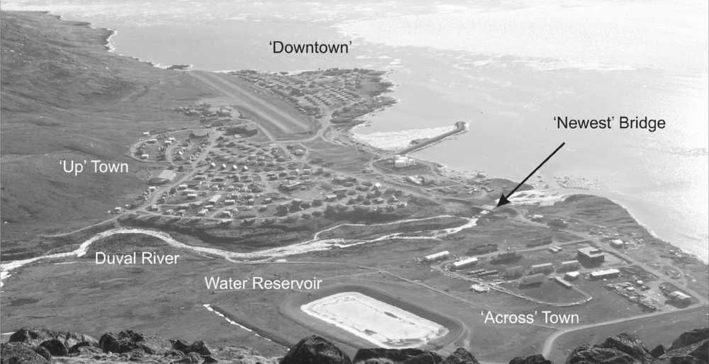
Located along a narrow stretch of coastal plain in the Pangnirtung Fiord is the community of Pangnirtung, Nunavut (see Fig. 1). The Duval River bisects the community of 1,443 residents (Government of Nunavut 2005); on one side is ‘Downtown’ (162 building units) and ‘Up’ Town (277 building units), while on the other side is Pangnirtung's newest, growing subdivision commonly referred to as ‘Across’ Town (64 building units). The river originates from two lakes in the mountains above the community and physically separates the majority of residences and community services including the Health Centre, the Northern and Co-Op Stores, the Post Office, and the schools, from a handful of residences along with the Government of Nunavut building, the garbage dump, the water reservoir, and sewage treatment facility. The primary language spoken in Pangnirtung is Inuktitut and over 90% of the total population identifies themselves as Inuit (Government of Nunavut 2005).
Aerial view of Pangnirtung, Nunavut including ‘Downtown’, ‘Up’ Town, ‘Across’ Town, the Duval River, water reservoir, and ‘Newest’ bridge.

Many residents regularly pay attention to the weather, although the sources they consult generally vary with age and time spent engaging in activities out ‘on the land’. In 2009, scientific forecasts issued by the Meteorological Service of Canada (MSC) were available to the residents of Pangnirtung via the internet, television, community radio, and a telephone hotline. Elders in the community rely heavily on their traditional skills to forecast the weather, yet at times incorporate portions of the scientific forecasts to either verify or modify their own interpretation of the weather. Adults and youth who spend time ‘on the land’ have some skill at producing traditional forecasts. More than elders, however, younger adults and youth tended to be users of forecasts, either by relying on the skills of their elders or by referring to the scientific forecasts provided by MSC. This is in keeping with forecasting methods used in other Nunavut communities (Ford and others Reference Ford, Pearce, Duerden, Furgal and Smit2010; Pennesi and others Reference Pennesi, Arokium and McBean2012).
The 2008 weather event: reactions and responses
It was amazing how you saw the permafrost; you know the grey permafrost, of how deep it did go down. And it made you realise that when you saw water come out nearly on a right angle, it made you realise that it had to have gone in somewhere and then come out. You know, because there were places that it was actually coming out at a right angle - gushing. It was then we realised that [the water] was going under the land (short term non-Inuit resident 1, living ‘Across’ town; 10 June 2009).
The following chronology of events is based on personal communications with Pangnirtung's Senior Administrative Officer and representatives of Environment Canada, information included in Jivko Engineering Report (2008), and blog reports posted online by Claus Vogel at ‘Tradewinds Photography’ during the 2008 weather event.
From 8–9 June 2008, over 40mm of rain fell in Pangnirtung. The runoff from the precipitation and rapid snowmelt from the surrounding mountains caused the Duval River to flood and the current quickly became intensely powerful. The event resulted in no loss of life, yet within 24 hours, erosion of the Duval River's shoreline had significantly compromised the stability of the town's working bridge. As the rain fell continuously on 8 June 2008, many residents stood adjacent to the river, listening to the thunderous sounds of boulders breaking from the shoreline and watching in amazement as the contour of the land changed in a way they had never seen before. They focussed their attention on how the river began to ‘run underneath the land’, causing certain areas on the northeast side to sink between 2.5 to 4.5 m (Jivko Engineering Report 2008). Municipal representatives, on the other hand, took closer notice of how the strong river exacerbated the widening of the riverbed, causing extensive degradation of the bridge's stability and utility. They concentrated on the damaged infrastructure, a consequence that they perceived as increasing community vulnerability.
Uncertain whether the bridge would remain intact, the municipal representatives and their employees quickly responded to what they perceived as a major crisis situation. Ten-centimetre piping was swiftly laid across the structure and water and sewage trucks were positioned on either side to ensure that delivery and removal of each, respectively, was maintained without interruption. Once assessments were conducted on the bridge's structural integrity, it was confirmed that extensive repairs were needed (Jivko Engineering Report 2008). Pangnirtung's Hamlet Council prohibited residents from using the bridge and instead organised a water taxi during high tide to connect residents on the northeast side of the river, or ‘Across’ town, with food and other community services located in ‘Downtown’.
By Tuesday, 10 June 2008, the municipal government declared a state of local emergency in order to mobilise resources to reestablish the community's services and infrastructure. Following this declaration, all government and non-governmental buildings in Pangnirtung were closed, including the schools. Meanwhile, local government officers arranged numerous contracts to repair the damaged bridge and access roads. Nunavut's territorial officials requested more than $5 million from the federal emergency protection plan to help cover the costs. A year later, the Government of Canada did agree to share some of the costs incurred by Nunavut through the Disaster Financial Assistance Arrangements (Public Safety Canada 2009). This was an important step in helping the community and the territorial government recover the emergency expenditures, which had significantly burdened the local economy. On Friday, 13 June 2008 both schools re-opened, but it was only on Sunday, 22 June 2008, that the water in the Duval River was free of silt, a positive sign that erosion of the shoreline and riverbed had stabilised. For nearly a month after the event, the council made daily Inuktitut and English radio briefs, apprising residents of geological assessments in progress, providing instructions for water rationing, and dispelling misinformation that had been broadcast by the media.
In the days and months that followed the storm, regional and national media generated online news reports based on their in-person or telephone discussions with a small sample of municipal representatives and residents. Our analysis of the available reports shows that all sources used descriptors that magnified the intensity and impacts of the rainstorm. They characterized the event as ‘fateful’ (The Innovator (Winnipeg, MB) October 2008), a ‘heavy flood’ (CBC 2008b), and evidence of ‘climate change’ (Grist Magazine (Seattle, WA) 13 October 2008). One source posed an alarming question: ‘Will Pangnirtung become one of the first communities to become uninhabitable because of climate change?’ (Nunatsiaq News (Iqaluit, NT) 8 August 2008). Others maximised the dramatic impact with passages such as ‘no access to municipal services’ (CBC 2008b) and ‘forced to dump raw sewage into the . . . pristine waters of the Pangnirtung Fiord’ (Harford Reference Harford2008). These reports garnered the attention of external reading audiences by providing a visible sign of a vulnerable northern community experiencing a severe weather event.
The excerpts shown here and in the discussion below illustrate the generally dire tone of the articles and demonstrate how the written text emphasized the severity of the event for the community and its residents. These dramatic descriptions contrast with those of residents who described the event as just another rainstorm, not a flood, and not a manifestation of a broader climate change phenomenon. Moreover, the reports suggest the event left Pangnirtung in a state of unavoidable suffering, whereas residents interviewed a year later emphasised that the event was ‘not a big deal’ and that the situation had been under control. In the following section we explore the different perspectives that underlie these divergent representations of the event.
Results and discussion: differing viewpoints
Our data reveal multiple levels of complexity surrounding interpretations of, and responses to, the 2008 weather event. First, residents, whether Inuit or non-Inuit, and independent of the language the interview was conducted in, tended not to interpret the weather and resultant bridge collapse as severe, unlike the three local government representatives. Second, residents differed from local government in their definition of a ‘severe’ consequence, leading to contrasting perceptions of vulnerability. Third, while the language used by government or journalists at the time of the event did little to heighten residents’ perceptions of vulnerability to the bridge collapse, terms used in interviews a year later to describe the reasons behind and implications of continued permafrost erosion demonstrate how particular ways of framing information shape local ways of knowing.
Key factors were found to influence these interpretations and responses including: different appraisals of threat, local beliefs regarding environmental change and uncertainty, and the communication of risk information. These factors shaped each group's assessment of whether or not a severe weather event had occurred, their perceived degree of vulnerability to the event, and how they coped with feelings of insecurity. We will discuss each of these in turn.
‘Severe’ weather and ‘severe’ consequences
Most Inuit participants reported ‘Pang winds’ as the most severe weather condition they experience. They expressed severity using words such as ‘dangerous’, ‘bad’, and ‘unusual’ when describing winds travelling up to 160 kilometres per hour. In the late 1970s, one of the worst wind storms in Pangnirtung's history caused the complete destruction of approximately five houses. One Inuit resident characterised the state of the community in the wake of that severe wind as a war zone: ‘Like how when I see in the movies. It was like after a war. Everything was everywhere’ (long-term Inuit resident #1, living ‘Up’ town; 26 June 2009). In reference to high wind events, residents talk about being ‘caught’ in a storm while out on the land, ‘caught’ outside and struck by flying debris, even ‘caught’ in unsecure shelter. Such descriptions of severe wind illustrate the harsh consequences that can result from extreme changes in meteorological conditions, namely destruction of personal property, chaos, and injury. The repetition of the word ‘caught’ is evidence of a shared sense of vulnerability when potentially hazardous conditions are not expected. These examples illustrate how residents conceptualise ‘severe’ and what being vulnerable means.
Participants perceived greater vulnerability when faced with severe winds than with rains causing a river flood. Despite the continuous rainfall on 8 June 2008, residents did not agree with local government's assessment that it was'near record breaking’. English and Inuktitut speaking residents commented that the rain was ‘not that bad’, ‘just a rainstorm’, and ‘nothing really new’. The fact that June is springtime in Pangnirtung, and rainy conditions are expected, helps to explain this difference in perception of severity.
The disastrous impacts brought on by wind events in the community over the last 30 years have enhanced Pangnirtung residents’ familiarity with, and resilience to, infrastructural damage. Familiarity with property damage during past wind events reduced the uncertainty residents associated with the bridge collapse and diminished their interpretations that this was a threat. In contrast to the local government, which conceived the bridge collapse as threatening and perceived a heightened sense of vulnerability as a result, several residents in the community referred to the bridge collapse as simply a matter of inconvenience. The following quote is an example:
If you would be interviewing other people about the bridge blow out, it was uh, what's the word, um, like an entertainment. It was, you know, we all would go down every day; there were groups of people standing on the shores just watching it happen. It was curiosity. And an inconvenience, but for us it wasn't a catastrophe because we just waited (short term non-Inuit resident 2, living ‘Downtown’; 23 June 2009).
The differing interpretations between the local government and residents regarding the presence or not of a threatening or ‘severe’ consequence are grounded in the multiple ways each group conceptualises threat. Blascovich and Mendes (Reference Blascovich, Mendes and Forgas2000: 60) argue that threat appraisal is a simultaneous interplay of emotional, cognitive, and physiological processes. In the case of the 2008 weather event, a combination of cognitive and emotional processes manifested in the worldviews held by both local government and residents were shown to influence the ways in which these groups conceptualized the presence or absence of threat.
Local government representatives in Pangnirtung did not have personal experience with an event where municipal services could be disconnected and a potential breech of the water reservoir could occur. They were required to evaluate what was and what was not threatening through an alternative, institutional lens. As government representatives, they were required to act as a single entity, considering factors not relevant to individual residents, such as preparing the community for weather-related emergencies, developing response strategies to variable degrees of exposure and impact brought on by significant weather conditions, as well as coordinating recovery efforts once the damage had been assessed. In the case of the 2008 weather event, such institutional requirements, along with pressures brought on by public opinion, limited the range of response options available to local government, causing them to cross the critical ‘threat’ threshold much sooner than that of residents. Determining that Pangnirtung lacked sufficient resources to cope with the problems, local government deemed the deep crevasses and the bridge collapse caused by the heavy rainfall threatening. This administrative perspective was more dominant than their personal experiences and Inuit values, as they acted in accordance with the municipal priorities and regulations.
In contrast, other residents did not have the responsibility for ensuring public safety in times of threatening weather. Guided by their individual values, the care-taking actions displayed by local government in the past, and understandings of unpredictability in nature, this group drew heavily on elements of their individual worldviews to appraise the bridge collapse as non-problematic. The impacts resulting from harsh wind events are well known to residents; injuries can be sustained and personal property can be damaged. In this case the bridge collapse caused neither. Whereas residents place high value on their physical well-being and their belongings, the bridge does not hold the same importance or connection, so its collapse did little to personally affect them.
Local government's responses to residents in need have also reinforced the role of community leaders as caretakers. When there is no power in the community, for example, municipal representatives distribute naphtha to each household. When a resident runs out of water, more can be delivered by placing a call to the Hamlet office. In much the same way, residents relied on official local support systems to respond adequately to the bridge collapse in 2008. The confidence that was exhibited in local leaders during this event partially explains why many residents did not consider the bridge collapse threatening.
The failure to identify the event as problematic can also be explained in reference to residents’ understandings of environmental unpredictability. Inhabitants of the Arctic are keenly aware of their highly unstable environment (Minc Reference Minc1986). When asked why the bridge collapse was not considered problematic for people in the community, one Pangnirtung resident reflected on the commonality of living with the instability of nature:
Here, because the land and nature is an unpredictable element and the people here are so very connected to a life on the land . . . you know, if you're out in your boat and the ice gets blown in you have to be patient. You have to wait. You don't panic- panic has no purpose; you wait for it to go away. Likewise if you're in town, and the bridge is gone, and you have no services you don't panic (short term non-Inuit resident 2, living ‘Downtown’; 23 June 2009).
Drawing on aspects of their individual worldviews, residents identified the weather conditions and infrastructural impacts as non-threatening. Although river floods and collapsed bridges are typically depicted by non-Arctic communities as disastrous and abnormal occurrences, residents in Pangnirtung have come to accept variable weather patterns in their community and the inconveniences brought on by such conditions. Krupnik's (1993) research demonstrates similar findings in that the Eurasian Arctic has experienced the occurrence of severe and extreme weather phenomena since the 19th century. Bankoff (Reference Bankoff2007: 26) refers to this acceptance as the normalization of threat. Similar to what he found in Filipino communities where residents have adapted to the constant exposure to hazards and environmental threats, residents of Pangnirtung are frequently exposed to hazardous and variable weather patterns. This frequent exposure propagates normalised reactions and responses such as the one expressed here by an lnuit resident:
Every year during spring melt, the Duval River melts and starts flowing again. Some years. . .the river becomes a deluge. All rivers up here become crazily dangerous for a couple of days. Last year was such a case. It was the same type of storm we get every year or every couple of years, sometimes every few months. . . Like I said I live right near the river and can see it through the bedroom window and it was nothing unusual, it was what we see almost every year, if a storm comes during the spring melt, the river becomes very big and fast (long-term Inuit resident 2, living in ‘Up’ town; 13 February 2009).
While the rain and bridge collapse were not considered threatening, the extensive erosion of permafrost and the development of deep crevasses perpendicular to the Duval River's shoreline elicited concern. Despite the highly variable weather long-term residents expect, they have had little experience with situations in which weather conditions produce permanent changes in the landscape. The novelty of these effects and the magnitude of the potential impacts on the community's survival increased residents’ situational uncertainty and influenced their appraisals of threat. A few elders spoke about the severity of such changes and identified the recession of glacial ice and permafrost as a certain reality with uncertain consequences. Potential threats that such changes could have include the loss of their main source of fresh drinking water and the stability of their community built entirely on permafrost. Two Inuit elders described their observations of the melting permafrost and the potential problems such changes posed for the well-being of their community:
Often [I] think that because there is so much permafrost here where we are and if it's melting and it start affecting the whole community maybe down the road the whole community might have to be moved to a different location. This is what [I] often thought to [myself] (long term Inuit resident 3, living ‘Downtown’; 12 June 2009).
But as you can see, the landscape really changed now. You see probably the permafrost melted and so that's why we had the mudslide. And it seems to be evidence that Pangnirtung might be in a really bad spot (long term Inuit resident 4, living ‘Downtown’; 12 June 2009).
From these examples, it is clear that the potential for relocation acted as an affective cue for these elders, eliciting negative emotional responses. This is possibly linked with their painful memories of forced relocation from the Cumberland Sound region to the settlement of Pangnirtung in 1962 (McElroy 1975: 664). The emotional responses prompted these residents to identify the presence of a threat, not from the rainfall or the failure of the manmade structure, but from the damage done to the land, which is the literal and symbolic foundation of the community.
In general, residents’ interpretations of the 2008 event exemplify understandings of their position in relation to the environment. Living in a remote northern community, patience must be exhibited and inconveniences are accepted as inevitable given the unpredictability of environmental processes. For some residents, however, the uncertainty surrounding the unprecedented extent of permafrost erosion created a scenario in which both feelings of insecurity were heightened and perceptions of vulnerability were amplified.
The influence of language on perceptions of vulnerability
Recently, hazardous weather events, such as the one in Pangnirtung, have been described by the media as visible signs of a dramatic change in the Earth's climate. By crafting narratives and linking singular weather events with global climate change, the media plays an integral role in shaping ideas of what constitutes risk and vulnerability within political, cultural, and environmental debates (Spence and Pidgeon Reference Spence and Pidgeon2010). To a certain degree, publics depend on news media to inform them of environmental processes, yet media reports about severe weather events are often based on interviews held with a limited number of individuals (Ashlin and Ladle Reference Ashlin and Ladle2007: 338; Smith Reference Smith2005: 1476). This attempt to create a single story results in a narrow view of the event and its impacts.
Framing the 2008 event as a manifestation of broader phenomena, by employing discourses about global warming and climate change, local government and media influenced how it was conceived of regionally and nationally, and subsequent perceptions of vulnerability. Rudiak-Gould (Reference Rudiak-Gould2011: 9) discusses such framing styles and calls for more ‘reception studies’, which acknowledge that individual conceptions of climate change are being influenced by observations in their local environment as well as the information available to them about what is happening worldwide. Based on several residents’ comments that climate change was a cause for the river flood, it is likely that previous conceptions for what constituted ‘climate change’, perhaps those presented by media, influenced these residents’ perceptions of the event.
In their daily local radio broadcasts to the community, municipal representatives presented the bridge collapse as a serious issue under control. In contrast, the information they provided to the CBC national news portrayed the event as a major crisis. The online news reports subsequently written by the CBC quoted local leaders saying things like, residents living on the north side of the river were ‘stranded’ (CBC 2008c), and that unless they rationed their water supply, ‘they're going to run out of water’ (CBC 2008a). These contrasting representations highlight what Kasperson and others (Reference Kasperson, Kasperson, Pidgeon, Slovic, Pidgeon, Kasperson and Slovic2003: 20) refer to as the layering effect in risk communication. In an effort to meet two conflicting objectives, the layering of risk messages by local government attempted to reduce residents’ perceptions of vulnerability, while at the same time emphasised to CBC and their viewers that the bridge collapse presented significant risks and economic constraints. With the help of the CBC, municipal representatives set different contexts and terms for the type of risk information that was communicated to local residents. This led to the attenuation of residents’ perceptions of risk related to the impacts of the June 2008 storm, and amplification of risk to media and viewers.
Methods of coping
Once thresholds of severity were crossed, affected residents and local government enacted different coping strategies to deal with the perceived vulnerabilities brought on by the circumstances. Contrasted here are the ‘emotion-focused coping’ strategies used by Inuit residents and the ‘problem-focused coping’ strategies used by local government (Carver and others Reference Carver, Scheier and Weintraub1989: 272).
Inuit residents cognitively restructured their conceptions and managed their perceptions of vulnerability to permafrost erosion through acceptance and religious belief. In accepting the consequences of cracks in the land and erosion of permafrost, they pointed to their belief in the natural environment as a sentient being, one that has the ability to feel threats and perturbations. They accepted that if an event occurs which disrupts the environment's harmonious balance, Mother Nature will restore the state of equilibrium. Moreover, these participants considered the cracks in the land and the erosion of permafrost as part of an ongoing, cyclical process whereby certain pieces of the land transform from one state to another continuously over time. Like the Inuit of Greenland (Nuttall Reference Nuttall, Crate and Nuttall2009: 298), some Inuit in Pangnirtung consider their environment to be in a process of ‘becoming’ rather than changing. This point was illustrated when one Inuit resident noted:
The land is always forming into new things. . . . If there was a camp before it could be washed out. There always has to be a new form of camp [. . .] always [a renewal of] things. That's how life goes (long term Inuit resident 6, living ‘Downtown’, 17 June 2009).
Therefore, irrespective of individual interpretations of ‘threat’ or the degree of severity attributed to the cracks and permafrost erosion, several Inuit asserted that it is not within human control to restore this balance and accepted the damage caused by the storm as part of the natural order.
Furthermore, Inuit residents relied on their deep faith in God to reduce their feelings of insecurity. At least two Inuit residents claimed that they prayed to God to protect the community and its people. Again, despite the perceived threat of the permafrost erosion, acts of prayer demonstrated that solving the ‘problem’ is beyond human control. Thus, many Inuit place their faith in a power greater than themselves, whether they assign control of the environment to Mother Nature or to God.
The emotion-focused strategies Inuit residents used to cope during the 2008 weather event contrast with the problem-focused strategies local government engaged in to fulfill their roles as leaders of the community, anticipating and preparing for any potential ‘problems’ and ‘threats’. The physical changes to the land and infrastructure presented uncertain consequences for the community and prompted government officers to plan and strategise as a unit, to consult with geologists and engineers, and to decide what was necessary to ensure the community's recovery. The assessments and measurements from the electronic monitoring device placed at the riverbed upstream from the site of physical damage serve as an example of an overt behavioral attempt to deal directly with the ‘threat’ and its effects (Billings and Moos Reference Billings and Moos1981: 141). This action provided the municipality with additional information so they could determine the consequences of the physical changes and the likelihood of future impacts. Identifying problems and solutions reduced the degree of uncertainty and, in turn, perceptions of community vulnerability.
Conclusions
The Pangnirtung case reinforces the idea that vulnerability is culturally defined, with multiple ideas of what it means to be vulnerable. Highlighting local perspectives and providing opportunities in research practices for participants to define the ways in which their vulnerabilities are measured will enhance vulnerability assessments. This research contributes to vulnerability studies by introducing concept definition and threat appraisal as foundational components of vulnerability assessments. Prior to determining the factors that may amplify or attenuate a group's perceptions of vulnerability to weather hazards, we must first ask how individuals within the group understand, interpret, and define the concept of severe weather itself. Including local ‘emic’ understandings for what constitutes severe weather improves the validity of assessments of vulnerability to weather events. The differing classifications for the words ‘severe’ and ‘vulnerable’ highlighted in this study underscore the importance and challenge of understanding local meanings. These concepts are commonly used in everyday language to describe how individuals feel and how they act, resulting in multiple and sometimes divergent interpretations of how they are used during significant weather events (O’ Brien and others Reference O’ Brien, Eriksen, Schjolden and Nygaard2004: 2).
This paper challenges future researchers to consider how conventional characteristics for assessing vulnerability may be complemented by locally relevant indicators. This is in keeping with Pennesi and colleagues (Reference Pennesi, Arokium and McBean2012) who maintain that integrating local weather knowledge into Iqaluit's weather service improves risk assessment and decision-making, ultimately reducing community vulnerability. Locally based indices are context specific, varying from place to place, from group to group, and even from person to person. The most important locally relevant indicator of vulnerability in this study was the extreme faith and confidence Pangnirtung residents have toward their local government. In other words, the trust residents have in their municipal representatives in times of need and ‘severe’ weather events was shown to play a major role in how residents understood the 2008 weather event, how they perceived their vulnerability toward it, and ultimately how they responded or acted. In addition, the normalisation of threat, local beliefs regarding environmental change and uncertainty, as well as the framing and communication of risk information all worked to diminish the severity and associated perceptions of vulnerability of the storm and bridge collapse from the perspective of residents. Analysis further showed that residents are content in passing the burden of planning and preparation onto the local government.
These findings are useful for reminding organisations wishing to assist in Arctic adaptation efforts, such as ArcticNet, that gaining and incorporating local insight or expert knowledge into adaptation strategies are necessary for their potential success. More than simply gaining local insight, however, our findings reveal that in Pangnirtung, involving local government in the design, approval, and implementation of local adaptation policies will probably increase resident support and mobilise their participation. While the importance of concentrating the means of adaptation in Arctic communities, rather than in external bureaucratic and technical systems, is now recognised (Ford and others Reference Ford, Pearce, Duerden, Furgal and Smit2010; Nadasdy Reference Nadasdy1999), in many first nations and Inuit communities in Canada, there is mistrust or conflict between local government and community members, making it difficult to implement policies requiring active citizen participation. Thus, the effectiveness of Pangnirtung's local government is something to be noticed and maximised.
Though the emotion-focused coping strategies residents exhibited during the 2008 event differed from the action-oriented strategies displayed by local government, they were useful for showing that residents of Pangnirtung do, in fact, utilise specific methods to manage the impacts of significant weather. In a similar way, Laidler and colleagues (Reference Laidler, Ford, Gough, Ikummaq, Gagnon, Kowal, Qrunnut and Irngaut2009: 387) found that continuously changing climatic conditions have helped to frame the evolution of individual decision-making and risk avoidance strategies in Igloolik. Pearce and colleagues (Reference Pearce, Ford, Duerden, Smit, Andrachuk, Berrang-Ford and Smith2011) similarly found that residents in Ulukhaktok, Northwest Territories have developed a number of adaptation strategies to deal with changing climatic conditions. The examination of our data specifically revealed that many residents perceived the coping strategies they enact during or in response to severe weather as satisfactory. Together, with the trust residents have in local government, this reveals that residents may be more inclined to utilise internal procedures such as improving the linkages between government and residents in the community before seeking external assistance to enhance coping strategies during severe weather.
The influence of language on perceptions of vulnerability emphasised how the portrayal of the 2008 weather event created different or shared meanings and understandings among Pangnirtung residents and the public at large. Social, cultural, and institutional processes mediated the presentation of images and the dissemination of text following the 2008 storm and bridge collapse, highlighting how such local and external understandings are shaped and transformed, and also how they changed over time.
This exploratory study provides useful insights for what were, and were not, considered extraordinary weather conditions and impacts in Pangnirtung in 2008. The research presented here differs from other ArcticNet studies in that it focuses more on vulnerabilities resulting from particular acute weather conditions rather than vulnerabilities resulting from climate-related exposure sensitivities (Laidler and others Reference Laidler, Ford, Gough, Ikummaq, Gagnon, Kowal, Qrunnut and Irngaut2009; Pearce and others Reference Pearce, Ford, Duerden, Smit, Andrachuk, Berrang-Ford and Smith2011). This study provides a foundation for subsequent longitudinal research assessing how perceptions of the event and its severity may have changed over time. Additional research could also address the potential implications of future river floods and permafrost erosion in Pangnirtung and/or across the Arctic. Comparative ethnographic studies of this nature would enhance understandings of how local populations conceive of severe weather and their vulnerability toward it. Where the present study was limited in its representation of perspectives from municipal government and youth, future work should provide greater focus on these groups to gain a fuller understanding of the views in the community and explore the implications of inter-generational differences in perceptions of vulnerability.
Acknowledgements
Financial support for this research was provided by ArcticNet Network of Centres of Excellence, The Northern Scientific Training Program, and the University of Western Ontario. The authors would like to thank Igor Krupnik, Gita Ljubicic, and other reviewers for their valued insights and helpful recommendations, and also Ed. Eastaugh for his assistance with Figure 1. We are grateful for the assistance and participation of meteorologist Yvonne Bilan-Wallace with the MSC, Jamal Shirley and the Nunavut Research Institute in Iqaluit, Andrew Dialla, Jonah Kilabuk and Eric Joamie who provided interpretation and translation services, and the residents of Pangnirtung.
Appendix: sample interview questions
The following questions from the interview schedule illustrate the kind of data the project generated.
Do you pay attention to the weather?
How do you learn about the weather each day?
How does weather affect your daily activities? Is it important for you to know the weather in advance?
If a storm is coming how do you prepare?
Tell me about a significant storm you experienced in Pangnirtung. Why does this event stand out in your memory?
How does that event compare to the last summer's rain and river flood?
How would you characterize last year's rain storm. In your opinion was it bad, a big deal, or severe?