Introduction
In contrast with East Antarctica, the geological record of the critical palaeoenvironmental and palaeoclimatic events which led to the development of the West Antarctic Ice Sheet is more fragmented and insufficiently known (Francis et al. Reference Francis, Ashworth, Cantrill, Crame, Howe, Stephens, Tosolini and Thorn2008). Consequently, uncertainties still persist regarding aspects of the Neogene climatic history of the continent, such as the glacial history of East and West Antarctica, the possible occurrence of preceding short-lived glaciations or whether the glacial history of the two parts of Antarctica were parallel (Barret Reference Barret1999, Troedsen & Smellie Reference Troedsen and Smellie2002).
Several papers which have attempted to answer these questions have analysed the Cenozoic sedimentary sequence which crops out at Seymour Island (Isla Marambio), particularly the glaciogenic rocks of the extensive plateau that dominates its northern part. This sequence encompasses the Miocene Hobbs Glacier Formation and the Pliocene Weddell Sea Formation, which unconformably overlie the Eocene La Meseta Formation, one of the most extensive units of the island.
One of the most important questions regarding the Seymour Island sedimentary record lies on the first glacial beds covering the marine sandstones of the La Meseta Formation. Ivany et al. (Reference Ivany, van Symaeys, Domack and Samson2006) described glacial deposits in this position, suggesting a late Eocene–early Oligocene age based on dinocyst stratigraphy and strontium isotopic data. This report was very important since it would represent the oldest glacial record in West Antarctica and suggests a synchronic initial expansion of the ice sheet across the whole continent. However, Concheyro et al. (Reference Concheyro, Salani, Adamonis and Lirio2007) suggested that the dinocyst assemblage analysed by Ivany et al. (Reference Ivany, van Symaeys, Domack and Samson2006) belong to the underlying La Meseta Formation, having been later reworked into the younger units. Furthermore, Marenssi et al. (Reference Marenssi, Casadio and Santillana2010) report the difficulty of revisiting the section described by Ivany et al. (Reference Ivany, van Symaeys, Domack and Samson2006) due to the low accuracy of the provided coordinates. Marenssi et al. (Reference Marenssi, Casadio and Santillana2010) described glacial deposits lying on the La Meseta Formation and assigned them to the Hobbs Glacier Formation, suggesting a Miocene age based on isotopic and fossil data. This complex scenario indicates that, although thin, the sedimentary successions preserved in Seymour Island are of Antarctic wide interest and need to be studied in detail.
Here we report the discovery of a boulder pavement at the base of the Hobbs Glacier Formation in the northern sector of Seymour Island, along the contact with the underlying La Meseta Formation. The data presented here were obtained during the summers of 2011 and 2013 during a detailed review of the Neogene sucessions of Seymour Island. The aim of this paper, therefore, is to contribute to the understanding of the complex Neogene climatic history of West Antarctica by disclosing a new glacial feature in one of the key areas of the James Ross basin.
Geological setting
The James Ross basin is a large back-arc basin formed behind the northern portion of the Antarctic Peninsula magmatic arc in response to the eastward subduction of the Antarctic and Phoenix plates between the late Mesozoic and early Cenozoic (e.g. Smith & Anderson Reference Smith and Anderson2010, Little et al. Reference Little, Birgel, Boyce, Crame, Francis, Kiel, Peckmann, Pirrie, Rollinson and Witts2015). In a broader approach, this basin has been considered as the northern portion (or sub-basin) of the Larsen basin, which encompasses the whole area west of the Antarctic Peninsula (Pirrie et al. Reference Pirrie, Duane and Riding1992, Smith & Anderson Reference Smith and Anderson2010).
The sedimentary succession deposited in the James Ross basin are the thickest and best-exposed onshore Cretaceous–early Palaeogene record in Antarctica (Francis et al. Reference Francis, Crame and Pirrie2006), emerging at several islands in the northern Weddell Sea, including James Ross Island, Snowhill Island and Seymour Island.
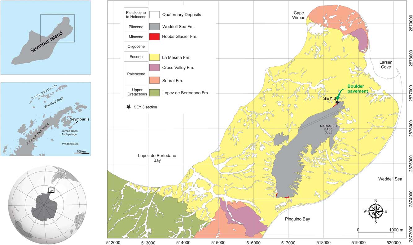
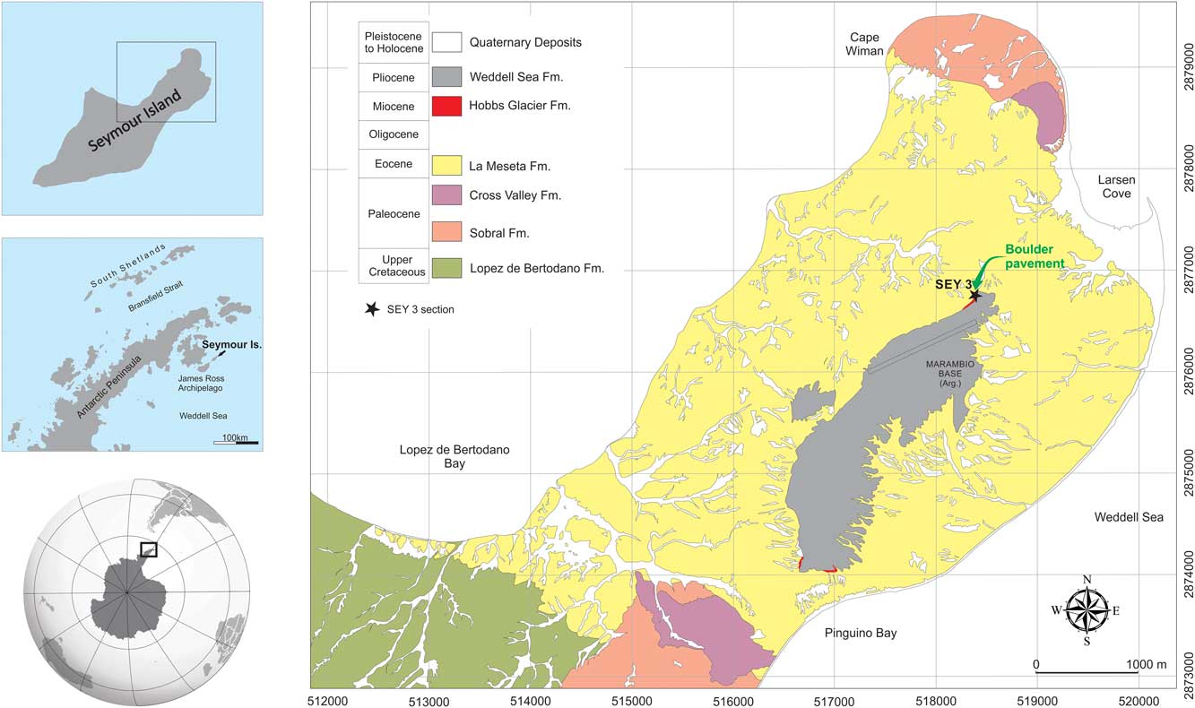
The infill of the James Ross basin is traditionally divided in three main units (e.g. Pirrie et al. Reference Pirrie, Duane and Riding1992): Gustav Group (Lower to Upper Cretaceous), Marambio Group (Upper Cretaceous–Palaeocene) and Seymour Island Group (Palaeocene–early Oligocene). In Seymour Island, the eastward dipping formations of the Marambio Group are unconformably overlain by the Palaeogene formations of the Seymour Island Group, which occupies the northern half of the island. In this region, the Cross Valley Formation is restricted to a small area around Cape Wiman, while the La Meseta Formation occurs widely (Fig. 1).
Partial geological map of Seymour Island (Isla Marambio) (based on Montes et al. Reference Montes, Nosal, Santillana, Marenssi and Olivero2008) showing the location of the SEY 3 point where the boulder pavement was found.
The up to 800 m thick section of the Eocene La Meseta Formation is composed mainly of fossiliferous shallow-marine fine sandstones with some shelly carbonate concretions and dispersed pebbles accumulated in an incised valley (Porebski Reference Porebski1995, Marenssi et al. Reference Marenssi, Santillana and Rinaldi1998). The available geochemical and palaeontological data indicate alternating cold and warm climatic conditions during the deposition of the unit (Ivany Reference Ivany2007).
At the central portion of the northern half of the island there is a km-sized plateau (so-called La Meseta) which is the culminating point and most prominent relief feature of the island (Malagnino et al. Reference Malagnino, Olivero, Rinaldi and Spikermanny1981). On its high slopes, at least two Neogene formations are recognized (see Fig. 1): the Miocene Hobbs Glacier Formation (Marenssi et al. Reference Marenssi, Casadio and Santillana2010) and the Pliocene Weddell Sea Formation (Gazdzicki et al. Reference Gazdzicki, Tatur, Hara and del Valle2004). Oddly, these formations are not formally assigned to any group.
The Hobbs Glacier Formation rests on an erosional unconformity on top of La Meseta Formation, comprising a lower member composed of a mud-silt with dispersed clasts and an upper member composed of mainly massive sands (Marenssi et al. Reference Marenssi, Casadio and Santillana2010). The thickness of the unit is quite variable ranging from 1 to 8 m, according to its basement palaeo-relief. Based on the presence of facetted clasts and marine fauna (bivalves in living position), Marenssi et al. (Reference Marenssi, Casadio and Santillana2010) interpreted these deposits as records of the re-sedimentation of glacially derived debris in a marine environment.
The topmost unit is the Weddell Sea Formation, which unconformably covers the Hobbs Glacier or La Meseta formations and marks the top of the plateau. This unit is composed of pebble to boulder-sized disoriented and often striated erratics, round or angular, immersed in a silty clay matrix, which is interpreted as terrestrial melt-out till (Gazdzicki et al. Reference Gazdzicki, Tatur, Hara and del Valle2004).
Description of the boulder pavement
The boulder pavement lies in the northern portion of the plateau, near to SEY 3 section (64°14'05.2''S, 56°37'12.7''W) at the base of the Hobbs Glacier Formation, resting on top of the La Meseta Formation (Fig. 1). The Hobbs Glacier Formation was previously identified there by Montes et al. (Reference Montes, Nosal, Santillana, Marenssi and Olivero2008) based on detailed (1:20 000 scale) geological mapping.
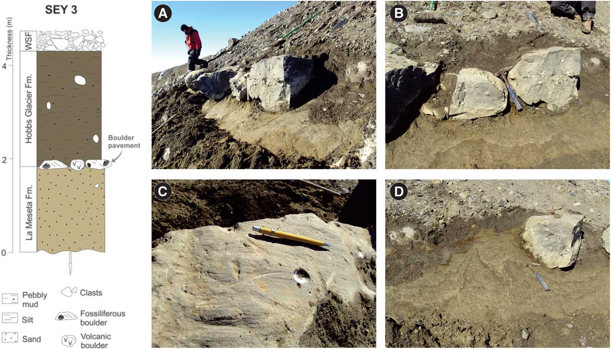
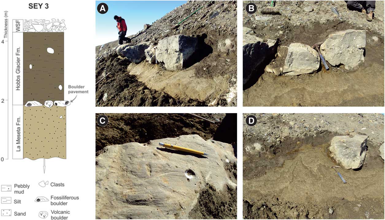
The excavation of the contact zone exposed at least eight boulders up to 60 cm wide spaced from centimetres up to a metre apart, forming a pavement which seems to extend laterally, but discontinuously, along the north-west edge of the plateau (Fig. 2).
Simplified stratigraphic section of the SEY 3 point where the boulder pavement was found and illustrative photos. a. & b. General view of the boulder pavement at section SEY-3. Note size of boulders and their upper faceted surface. Lighter=La Meseta Formation, darker=Hobbs Glacier Formation. c. Three intersecting striae on a boulder upper surface (mean direction: south-east). d. Irregular and v-shaped deformation below the clasts of the boulder pavement. Clasts are immersed on La Meseta Formation sands and covered by silts of the Hobbs Glacier Formation.
The clasts that make up the pavement are predominantly of ochre to brownish massive sandstones highly cemented with carbonate and hosting a plethora of fossil bivalves. The source of these clasts is easy to track since these fossiliferous carbonate concretions are very common in the upper portion of the La Meseta Formation. A single boulder of fine to medium grained vesicular volcanic rock was also found and its provenance (whether the James Ross Volcanic Group or the Antarctic Peninsula Volcanic Group) remains unclear.
The clasts have a sharply cut upper face that varies in extent and contains one to three sets of parallel or slightly intersecting sets of striae (Fig. 2). The striae on all boulders show consistent directions with little variation between N85–105E. The sense of movement of glacial erosion was toward E–SE, as indicated by small stoss-and-lee structures carved in the upper face of some clasts. Nevertheless, the clasts do not show a bullet shape and their long axes show no preferential orientation, as is common in terrestrial boulder pavements.
The sand deposits under and between the boulders show v-shaped deformation features, which seem to have been created by vertical downward deformation of the sands of the underlying La Meseta Formation (Fig. 2). Other features found along the contact between Hobbs Glacier and La Meseta formations around the area include fractures, intercalation of the sediments (glaciotectonism?) and possibly periglacial features (sand wedges).
Discussion
Glacial boulder pavements are horizontal or planar, one clast thick concentration of clasts that may occur intercalated (intratill pavements) or between two superposed tills (intertill pavements) (Clark Reference Clark1991, Benn & Evans Reference Benn and Evans1998). Clasts found in pavements vary in size from pebbles to large boulders and are usually angular to round. Most clasts have bevelled tops bearing parallel, consistently oriented striae, often together with other glacial erosion features (e.g. crescentic marks, chatter marks; Rocha-Campos et al. Reference Rocha-Campos, Farjallat and Yoshida1969) and may have their long axes oriented with striae. In plain view, boulder pavements resemble stone-paved roads, hence the name.
Some of the features observed in the Seymour Island boulder pavement provide clues to interpreting its origin: i) no subglacial diamict (lodgement till) was identified with the boulder pavement, since beds below and above consist, respectively, of shallow-marine pebbly sands (La Meseta Formation) and marine pebbly mud (Hobbs Glacier Formation), ii) the boulders show no preferential orientation of its long axis, and iii) up to three sets of striae are shown on top of the boulders, showing slightly different but consistent directions.
Terrestrial boulder pavements are usually associated with lodgement till deposits and show mainly bullet shaped striated clasts with strong long axes orientation, a typical feature of transport at the glacier base (Brookfield et al. Reference Brookfield, Merritt and McMillan2010). In contrast, the features of intertidal boulder pavements are related to washing out of fine sediments and the concentration of boulder lags in shallow seas, followed by multicyclic abrasion and transport by grounded ice shelves (Dione Reference Dione1981, Eyles Reference Eyles1988, Reference Eyles1994, Eyles & Lagoe Reference Eyles and Lagoe1990). In this case, since the ice cover is raised and grounded repeatedly the boulders could show divergent scratch alignments and have neither their long axes oriented nor the typical bullet shape (Eyles Reference Eyles1988, Reference Eyles1994, Brookfield et al. Reference Brookfield, Merritt and McMillan2010).
Therefore, we conclude that the Seymour Island boulder pavement shows tidal-marine characteristics, which are consistent with the environmental context of the Hobbs Glacier Formation (Marenssi et al. Reference Marenssi, Casadio and Santillana2010). In short, the origin of the boulder pavement on Seymour Island would have involved the generation of a lag concentration of clasts by winnowing of fines of a subglacial till by tidal action, erosion and striation of clasts by a floating ice shelf advancing on the lag. Curiously, such marine boulder (lag) pavements in front of receding glaciers are common features in the modern environments of the South Shetland Islands archipelago.
In comparison with the more intensively glaciated area of the Peninsula that has been subject to intense investigation related to its Cenozoic palaeoclimatic record (Jonkers et al. Reference Jonkers, Lirio, del Valle and Kelley2002, Smith & Anderson Reference Smith and Anderson2010, Davies et al. Reference Davies, Glasser, Carrivick, Hambrey, Smellie and Nyvit2013), Seymour Island and other islands are interpreted as exhibiting the correlative glaciomarine record of the palaeoclimatic changes that affected West Antarctica (Hjort et al. Reference Hjort, Ingólfsson, Moller and Lirio1997). Generally, the monotonous neocenozoic sedimentary record preserved around the Seymour Island plateau is less variable than the equivalent glacigenic sequences exposed on Ross Island, for example (Smith & Anderson Reference Smith and Anderson2010). These glacigenic features, including boulder pavements, are associated with till-rich deposits typical of terrestrial glacial deposits (Davies et al. Reference Davies, Glasser, Carrivick, Hambrey, Smellie and Nyvit2013).
Conclusion
The boulder pavement identified in the base of the Hobbs Glacier Formation at the northern tip of the Seymour Island plateau shows characteristics of tidal-marine environments, which is consistent with the palaeogeographical context of such unit. Within this context, the genesis of the boulder pavement would involve two phases: i) generation of a lag concentration of clasts by winnowing of fines by tidal or sea action and ii) striation of clasts by a floating ice shelf advancing on the lag.
We consider that the recognition of a marine tidal-controlled boulder pavement in the Cenozoic sequence of Seymour Island is relevant for understanding the climatic evolution of the James Ross basin. This finding could help to constrain the extent of the ice during the Miocene and reveal the relative proximity of the shoreface, which is useful to envisage the palaeogeographical scenario of the Antarctic Peninsula Region during such times. Regarding the tectonic and stratigraphic evolution of the Seymour Island Cenozoic units, the identification of such tidal features is also important since they record a new episode of emersion of the James Ross basin deposits, which may have been tectonically or eustatically controlled.
Acknowledgements
We thank the chiefs and personnel of the Marambio Station, Fuerza Aerea Argentina (Dotaciones 2011–12) for their wonderful hospitality and cooperation during fieldwork on Seymour Island. We also thank Dr Sergio Marenssi, Dr Rodolfo Del Valle, Dr Jorge Santillana and Mr Jorge Luski from the Instituto Antartico Argentino for their kind support, and two anonymous reviewers and Dr Cliff Atkins (editor of Antarctic Science) whose suggestions contributed to improve this manuscript. This research was financed by the Conselho Nacional de Desenvolvimento Científico e Tecnológico (CNPq – PROANTAR, Proc. No. 5570362009-7).
Author contribution
ACR-C, MK, WD, PRS and FMC contributed equally to fieldwork, data analysis and interpretation.