Introduction
Grassland ecosystems covering some 25% of the Earth’s landmass play critical roles in carbon sequestration, retain high biodiversity, act as valuable habitats and provide resources for livestock globally (Suttie et al. Reference Suttie, Reynolds and Batello2005). However, human exploitation, including conversion to croplands, fragmentation and over-grazing, have caused massive losses of grassland habitats over the last century (Ceballos et al. Reference Ceballos, Davidson, List, Pacheco, Manzano-Fischer and Santos-Barrera2010). Almost half of global grasslands may have been degraded (Bardgett et al. Reference Bardgett, Bullock, Lavorel, Manning, Schaffner and Ostle2021). This loss has also affected the grassland-dependent fauna, including c. 5% of global birds and c. 6% of mammalian biodiversity (Ceballos et al. Reference Ceballos, Davidson, List, Pacheco, Manzano-Fischer and Santos-Barrera2010). This problem is particularly acute in regions where significant amounts of grasslands and associated biodiversity exist outside the protected area network (Karanth et al. Reference Karanth, Nichols, Karanth, Hines and Christensen2010). Implementing necessary management is often challenging in these regions owing to a lack of appropriate information on the status, distribution and significance of the grasslands and associated fauna (Karanth et al. Reference Karanth, Nichols, Karanth, Hines and Christensen2010).
India currently retains some of the most biodiversity-rich savanna-grassland habitats within the subcontinent, characterized predominantly by C4 grasses and a woody layer of deciduous/evergreen trees (Ratnam et al. Reference Ratnam, Bond, Fensham, Hoffmann, Archibald and Lehmann2011). Covering c. 24% of the total landmass of India (Rawat & Adhikari Reference Rawat and Adhikari2015), these grasslands have been considered as wastelands since the colonial period, resulting in systematic management lapses (Vanak Reference Vanak2019, Lahiri et al. Reference Lahiri, Roy and Fleischman2022). Subsequent unprecedented anthropogenic pressures (habitat encroachment and rampant plantation programmes) have led to major conservation challenges regarding grasslands and grassland-dependent fauna (Vanak Reference Vanak2019). One such landscape that has undergone extensive grassland decline is that of the Terai and upper Gangetic Plains in northern India. Among the most biodiversity-rich areas in India (Johnsingh et al. Reference Johnsingh, Ramesh, Qureshi, David, Goyal and Rawat2004), this area has undergone massive habitat modification (cropland conversion, plantations, establishment of human settlements, etc.; Johnsingh et al. Reference Johnsingh, Ramesh, Qureshi, David, Goyal and Rawat2004) post-independence and retains one of the country’s highest human densities (Registrar General & Census Commissioner of India 2011). Currently, the grasslands are found along the basins of the Sharda–Ghagra (Terai region) and Ganges rivers (upper Gangetic Plains) as fragmented patches within the states of Uttarakhand and Uttar Pradesh (Government of India Planning Commission 2006, Paul et al. Reference Paul, Sarkar, Patil, Ghosh, Talukdar and Kumar2020). While most of these grassland habitats retain many threatened species like one-horned rhinoceros, swamp deer and hog deer (Qureshi et al. Reference Qureshi, Sawarkar, Rahmani and Mathur2004), the two basins experience very different management regimes. A significant part of the grassland habitats in the Sharda basin lies within protected areas, while a large portion of the grasslands in the Ganges basin is unprotected (Paul et al. Reference Paul, Sarkar, Patil, Ghosh, Talukdar and Kumar2020). The upper Gangetic Plains grasslands along the Ganges have been identified and mapped, and reports of swamp deer and other fauna (hog deer, smooth-coated otter, fishing cat, sarus crane, black-necked stork and bar-headed goose; Paul et al. Reference Paul, Pandav, Mohan, Habib, Nigam and Mondol2018, Reference Paul, Sarkar, Patil, Ghosh, Talukdar and Kumar2020) indicate their importance as critical wildlife habitats. However, the lack of detailed knowledge regarding the status of these grasslands is hampering management plans, even though this area has been identified as an important landscape for grassland fauna and represents the western-most distribution of the grassland-obligate swamp deer (Rawat & Adhikari Reference Rawat and Adhikari2015). Furthermore, the complexities associated with a highly dynamic landscape that represents a multi-state mosaic of protected (Hastinapur Wildlife Sanctuary (HWLS) in Uttar Pradesh and Jhilmil Jheel Conservation Reserve (JJCR) in Uttarakhand) and non-protected areas call for a detailed understanding of the current and historical status and ecological importance of these grassland habitats.
We combined field and geographical information system (GIS)-based tools to evaluate the status of the grasslands of the upper Gangetic Plains in the present and over the last 30 years. We conducted extensive field surveys (2015–2016) and mapped all the grassland patches (using visual classification) and other important land-use and land-cover (LULC) classes along the Ganges river between Haridwar (Uttarakhand) and Garhmukteshwar (Uttar Pradesh) in 2015. We then visually mapped the same LULC classes in the years 1985, 1995 and 2005 on a GIS domain using the 2015 information as a reference and quantified the changes in habitat during this period. Furthermore, we used radiotelemetry and habitat suitability modelling to understand swamp deer habitat use patterns and to identify suitable habitats in the study area. The swamp deer (Rucervus duvaucelii; categorized as Vulnerable on the International Union for Conservation of Nature (IUCN) Red List, listed in Appendix I of the Convention on International Trade in Endangered Species of Wild Fauna and Flora (CITES) and listed on Schedule I of the Wildlife Protection Act, 1972; Duckworth et al. Reference Duckworth, Kumar, Pokharel, Baral and Timmins2015) was selected as a focal species due to its obligate grassland-dwelling nature, high susceptibility to extinction (Karanth et al. Reference Karanth, Nichols, Karanth, Hines and Christensen2010) and grassland flagship status (Paul et al. Reference Paul, Pandav, Mohan, Habib, Nigam and Mondol2018). We speculated that the grassland habitats would shrink during the 1985–2015 timeframe, leading to possible swamp deer use of other LULC classes currently. Furthermore, we discuss the conservation implications of the results and suggest management actions to ensure the long-term conservation of this ecosystem.
Materials and methods
Study area and design
This study was conducted in part of the northern swamp deer habitat along the Ganges river covering the states of Uttarakhand and Uttar Pradesh (29°79'99"N, 78°21'71"E to 28°77'34"N, 78°13'57"E). The entire area covers c. 3173 km2 between JJCR in Uttarakhand and HWLS in Uttar Pradesh. The study area is 53% protected (1677 km2 in HWLS and JJCR) and 47% (1496 km2) unprotected. The Ganges river flows through the centre of the study area (c. 180 km length) and is joined by its tributaries Banganga and Solani in Uttar Pradesh. This region has been identified as the only major swamp deer habitat along the Ganges (Paul et al. Reference Paul, Pandav, Mohan, Habib, Nigam and Mondol2018, Reference Paul, Sarkar, Patil, Ghosh, Talukdar and Kumar2020) and is amongst the most densely human-populated areas in India (1164 people/km2 compared to the national average of 382 people/km2; Registrar General & Census Commissioner of India 2011). The study extended up to a distance of 8 km from either bank of these three rivers (Fig. S1). Agricultural fields, villages, townships, grassland patches, scrubland and forests make up the majority of the mosaic in this human-dominated region. Despite human dominance, this area harbours diverse flora (Saccharum spontaneum, Saccharum bengalense, Imperata cylindrica, Cynodon dactylon, Typha angustata, Phragmites karka and Arundo donax) as well as fauna (Paul et al. Reference Paul, Pandav, Mohan, Habib, Nigam and Mondol2018). The entire study design aimed to use different methods (Fig. S2) to determine (1) grassland status and change detection and (2) current habitat usage by swamp deer.
Grassland status and change detection
Initial searches in Google Earth revealed the following broad land-use types: cropland, grassland, waterbody, settlement, forest and scrubland. A stratified random sampling approach was then adopted where 3253 km along both banks of the Ganges, Banganga and Solani (180, 66 and 70 km stretches, respectively) were surveyed on foot or by tractor, vehicle or boat during April–June of 2015 and 2016. The coordinates of different LULC classes were recorded as ground points (survey design modified from Paul et al. Reference Paul, Pandav, Mohan, Habib, Nigam and Mondol2018). We collected a total of 656 GPS points for training, representing six different LULC classes, since the landscape is heterogeneous and dynamic (Fig. S3; Tripathi et al. Reference Tripathi, Ramachandran, Tripathi, Badola and Hussain2022, Tiwari et al. Reference Tiwari, Mishra, Singh and Singh2023).
We downloaded Landsat images (United States Geological Survey) for 2015 (Landsat 8) with a 30m resolution (Fig. S4 & Table S1) and performed atmospheric corrections (see details in Appendix S1). We generated spectral profiles for the six LULC classes (one GPS location per class) using standard false colour composite band combination (Fig. S5; Khan et al. Reference Khan, Chatterjee, Akbari, Bhatti, Dinda and Mitra2017). We then visually interpreted the Landsat images by digitizing the vectors (as polygons) on top of the images using image representations of key elements (size, tone, texture, shape and pattern) of different LULC classes and field knowledge (656 GPS points). This visual classification was chosen because extensive field information was available, and the classification was done at a scale of 1:50 000 (Puig et al. Reference Puig, Hyman and Bolaños2002) and the six above-mentioned LULC classes were categorized. Furthermore, we randomly selected 100 points (covering all of the LULC classes) for validation in the field and assessed the accuracy through κ statistics (Verma et al. 2020; see details in Appendix S1). The total area of different LULC classes was calculated in ArcGIS 10.2.2.
Similarly, the LULC maps of 2005 (Linear Imaging Self-Scanning Sensor (LISS) III), 1995 (LISS I) and 1985 (Landsat 4 Thematic Mapper (TM)) were generated through visual interpretation using reference ground data points of each class from 2015 (Fig. S4 & Table S1). For LISS III and LISS I, images were rescaled to 30m resolution. We calculated the area and net decadal changes for each LULC class between 1985 and 2015. As the majority of changes in the landscape were restricted to grassland and cropland, we focused our analysis on the changes to these two LULC classes. Using the ‘Union’ tool in ArcGIS 10.2.2, a matrix was generated for interpreting the interchange of selected LULC classes (grassland, cropland and waterbody).
Northern swamp deer ranging pattern, habitat use and suitability
Standard approaches of radio-collaring (darting from vehicle, elephant back, hides, etc.) are extremely challenging regarding swamp deer due to their specific habitat preferences (Qureshi et al. Reference Qureshi, Sawarkar, Rahmani and Mathur2004) and sensitivity to human presence. We used the drive-net method (Locke et al. Reference Locke, Hess, Mosley, Cook, Hernandez and Parker2004) to capture and collar two apparently healthy adult female swamp deer (GPS satellite collars) in JJCR during May–June 2018 (see details in Appendix S1). The collared animals were monitored, respectively, for 14 months (Female 1; 4998 GPS locations) and 11 months (Female 2; 3792 GPS locations), using both on-ground tracking and satellite information.
Using the Brownian Bridge Movement Model (BBMM), we estimated the home ranges of collared swamp deer during May 2018–July 2019. We selected a fine-scale grid cell size of 30 m as we did not have any prior information on swamp deer movement patterns. We prepared 50% and 95% BBMMs to represent the core area of use, time of activity and the standard home range size using the ‘BBMM’ package (Nielson et al. Reference Nielson, Sawyer and McDonald2015) in R software (Horne et al. Reference Horne, Garton, Krone and Lewis2007). Furthermore, we plotted these home ranges within the different LULC classes of the study area.
We plotted the proportion of all GPS locations from both collared individuals in each LULC class for an initial analysis to obtain a qualitative idea of habitat selection without considering habitat availability. We further assessed swamp deer habitat selection (taking habitat availability into account) using Ivlev’s electivity index (Equation 1; Ivlev Reference Ivlev1961):
 $${\rm{Ivlev's\;index}} = \left( {u - a} \right)/\left( {u + a} \right)$$
where u is the proportion of GPS points in a particular LULC class (use) and a is the proportion of a particular LULC class available (availability). We defined a part of the entire study area (depending on the extent of GPS points of swamp deer) as habitat availability for first-order selection (landscape level), whereas the 95% and 50% BBMM home ranges were considered for second-order selection (home range of the individual; Buskirk & Millspaugh Reference Buskirk and Millspaugh2006). We also plotted the proportional use versus availability of different LULC classes (grassland, cropland and waterbody) at the three levels (landscape, 95% BBMM and 50% BBMM). We calculated Ivlev’s index at three levels using the seasonal data (summer (March–June), monsoon (July–October), winter (November–February)). To understand swamp deer temporal habitat use in different LULC classes, we conducted a temporal trajectory path continuity analysis (Lyons et al. Reference Lyons, Turner and Getz2013, Qi & Du Reference Qi and Du2013; see details in Appendix S1).
In the non-protected areas, we deployed camera traps around the core home ranges of the collared animals to understand human–swamp deer temporal overlaps. To increase the photograph capture rate, infrared motion-sensor cameras (Cuddeback, Green Bay, WI, USA) were strategically placed covering grassland trails, grassland–cropland interfaces and areas between two small grassland fragments. The camera-trapping was conducted in three sessions between July 2018 and May 2019, with a total effort of 376 trap-nights (see details in Appendix S1). We calculated the temporal overlap between humans and swamp deer using the ‘CamTrap’ package in R (parameters; deltatime >15 min, overlap estimator used = Dhat4, 95% confidence interval (CI) of overlap generated by bootstrapping 999 samples; Niedballa et al. Reference Niedballa, Sollmann, Courtiol and Wilting2016, Vilella et al. Reference Vilella, Ferrandiz-Rovira and Sayol2020). The significance in temporal activity differences between swamp deer and humans was assessed using the Watson U 2 test (Rubio et al. Reference Rubio, Castro-Arellano, Mills, List, Ávila-Flores and Suzán2017).
We conducted habitat suitability analyses at the level of the entire study area because our inferences regarding swamp deer home ranges and habitat use are based on just two collared individuals. For this, we modelled habitat suitability using MaxEnt software version 3.3.3k (Phillips et al. Reference Phillips, Anderson and Schapire2006) using 70 spatially filtered points from this study and earlier recorded swamp deer presence data (1 point/km2) and five covariates (i.e. the six LULC classes, annual precipitation, human population density, nightlight and distance from water; see details in Appendix S1 & Tables S2 & S3). To assess important variables, a Jackknife analysis was performed (Phillips Reference Phillips2017). We used receiver operating characteristic (ROC) area under curve (AUC) values to assess the qualitative characterization of the model (Phillips et al. Reference Phillips, Anderson and Schapire2006). The AUC value of a model ranges from 0 to 1, where the 0.9–1.0 range is considered a good fit (Hemsing Reference Hemsing2010). The minimum probability of MaxEnt logistic prediction was set to ‘10 percentile training presence Logistic threshold’ (Sharma et al. Reference Sharma, Arunachalam, Bhavsar and Kala2018) as mentioned in the outputs given by the MaxEnt software. We pooled all of the prediction probabilities (based on the 10th percentile training presence logistic threshold value) to create areas with high and low suitability based on the mid-value of the prediction range (Paul et al. Reference Paul, Sarkar, Patil, Ghosh, Talukdar and Kumar2020). Furthermore, we assessed the total area of suitable habitat for swamp deer both inside and outside protected areas and identified the important areas that need management attention.
Results
Temporal land-use and land-cover change during 1985–2015
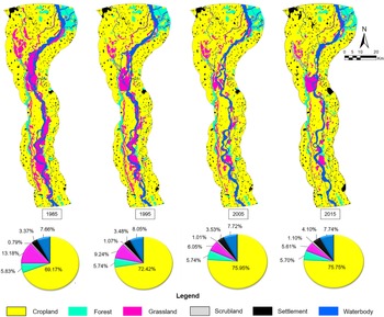
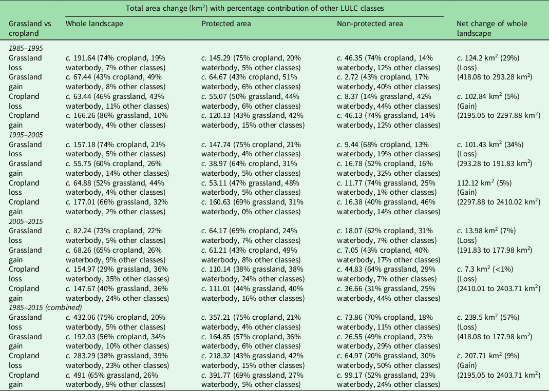
Our 656 field-collected data points representing the cropland, grassland, forest, waterbody, settlement and scrubland LULC classes helped to visually classify the Landsat image. Ground-truthing showed an overall accuracy of 90% (κ coefficient 0.88; Table S4). In 2015, cropland was the dominant LULC class (76%), followed by waterbody (7%), forest (6%), grassland (6%), settlement (4%) and scrubland (1%). There had been an increase in cropland from 69% (1985) to 76% (2015), whereas the grassland had declined from 13% (1985) to 5% (2015; Fig. 1). Grassland–cropland changes within the protected areas (c. 1636 km2 within HWLS) and non-protected areas (c.1496 km2 area) showed that c. 193 km2 and c. 47 km2 of grassland area were lost, respectively, during 1985–2015. Thus, a net reduction of 57% in grassland occurred over the whole landscape, 46% within protected areas and 11% within non-protected areas. JJCR (c. 41 km2 area covering 1% of the landscape) was not considered in this analysis as it was designated as a protected area in 2005 (Sinha & Chandola Reference Sinha and Chandola2006). Cropland showed corresponding increases of c. 173 km2 and c. 34 km2 within and outside protected areas, respectively. Overall, a net gain of 9.0% in cropland occurred in the landscape: 7.5% inside protected areas and 1.5% outside protected areas. The majority of this grassland loss was attributed to cropland conversion (74%) followed by waterbody (20%) and other classes (6%), whereas the increase in cropland was due to grassland loss (65%) followed by waterbody (26%) and other classes (9%; Table 1).
Land-use and land-cover (LULC) patterns in the study area over three decades (1985–2015). Pie charts show the percentages of the different LULC classes at each interval.

Changes in grassland and cropland areas and the major land-use and land-cover (LULC) classes (grassland/cropland/waterbody) contributing to these changes during 1985–2015. Decade-wise and overall, changes are presented within the whole landscape, protected areas (Hastinapur Wildlife Sanctuary only) and non-protected areas.

Swamp deer ranging pattern, habitat use and suitability
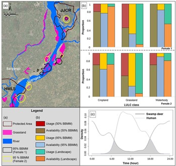
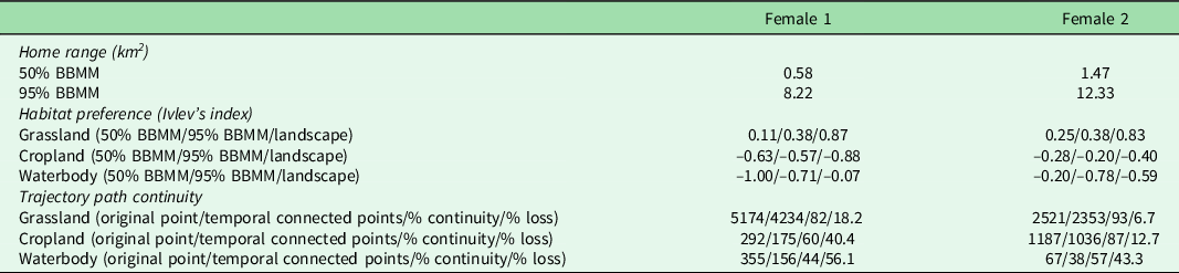
The average 95% BBMM home range of the individuals was 10.27 km2, covering grassland (32%), cropland (30%) and waterbody (25%) habitats. However, the average intensive-use area (50% BBMM home range) was 1.02 km2 (Fig. 2a & Table 2), and this consisted of 62% grassland, 29% cropland and 1% waterbody, indicating intensive use of the small grassland patches as core habitats.
Swamp deer home-range and habitat-use patterns ascertained through radiotelemetry. (a) Spatial representation of two female swamp deer home ranges (95% BBMM). (b) Proportion of use vs availability of grassland, waterbody and cropland classes for two collared females at different scales (landscape, 50% and 95% BBMM). (c) Temporal segregation between swamp deer and humans. BBMM = Brownian Bridge Movement Model; HWLS = Hastinapur Wildlife Sanctuary; JJCR = Jhilmil Jheel Conservation Reserve; LULC = land-use and land-cover.

Details of swamp deer (n = 2 females) home ranges (50% and 95% Brownian Bridge Movement Models (BBMMs)), habitat preferences (Ivlev’s Index) and temporal continuity of trajectory paths. The habitat preferences have been calculated at three scales (landscape level, 50% and 95% BBMM), and trajectory path analysis was conducted for major land-use and land-cover classes (grassland, cropland and waterbody).

The qualitative analysis of habitat selection (not considering availability) for both the collared individuals suggested 81% of GPS locations were within grassland habitats, followed by cropland (15%) and waterbody (4%). Ivlev’s index indicated that both animals preferred grassland habitats and avoided forests, scrublands, settlements and waterbodies, with some sporadic use of cropland. At the landscape level (1714 km2 area between JJCR and Bijnor Barrage considered as habitat availability for first-order selection), the Ivlev’s index values for grassland were highest for both individuals (Female 1 = 0.87, Female 2 = 0.83) when compared to 95% BBMM (Female 1 = 0.38, Female 2 = 0.38) and 50% BBMM (Female 1 = 0.11, Female 2 = 0.25; both second-order selections; Table 2). Similar trends were observed for the proportion of use versus availability analyses (Fig. 2b). When Ivlev’s index was calculated using seasonal data, grassland showed the highest value across all seasons at all scales, except in the cases of 50% BBMM during monsoon for the two individuals (Female 1 = 0.3 for cropland and 0.17 for grassland, respectively; Female 2 = 0.02 and –0.02 for cropland and grassland, respectively; Table S5).
Further analysis revealed that grassland had the highest temporal continuity followed by cropland and waterbody (Table 2). Camera-trapping captured 403 and 157 photographs of swamp deer and humans, respectively. The data indicated the presence of small groups (3–4 individuals/group) within both the collared individuals’ core habitat regions, which were also important rutting and fawning grounds (Fig. S6b,c). Swamp deer activities were temporally separated (frequency = 0.94, 6:00 p.m.–6:00 a.m.) from those of humans (frequency = 0.95, 7:00 a.m.–4:00 p.m.; U 2 = 7.41 p < 0.001), with a 21% overlap (Dhat4 = 0.21, 95% CI = 0.16–0.26; Fig. 2c).
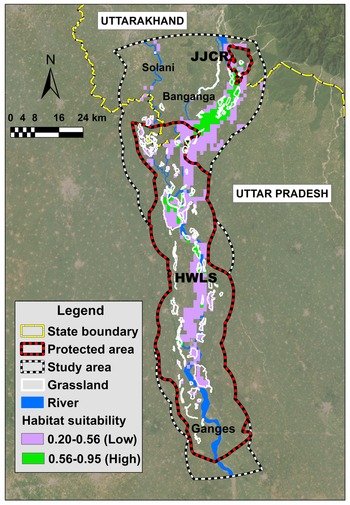
MaxEnt results indicated that most of the suitable swamp deer habitats are along the Ganges, Solani and Banganga rivers. Based on the model predictions, only c. 17% of the entire study area was found to be suitable as swamp deer habitat. The highly suitable areas (prediction probability between 0.56 and 0.93) consisted of c. 117 km2, mainly between JJCR and Bijnor Barrage along the Ganges (c. 4% of study area), whereas the low-suitability areas (prediction probability between 0.20 and 0.56) consisted of c. 420 km2 (c. 13%) around the Solani river and south of Bijnor Barrage (Fig. 3). Furthermore, c. 46 km2 (39%) and c. 71 km2 (61%) of highly suitable habitats, respectively, were present in protected and non-protected areas. LULC classes (26.8%) and distance from water (25.4%) were the most critical predictors of swamp deer habitat suitability. Of all LULC classes, grassland contributed most to the habitat suitability (predicted suitability = 0.77, AUC = 0.904; Figs S7 & S8).
Habitat suitability map for swamp deer representing both high- and low-suitability areas in the upper Gangetic Plains. HWLS = Hastinapur Wildlife Sanctuary; JJCR = Jhilmil Jheel Conservation Reserve.

Discussion
Our study presents probably the most exhaustive quantitative assessment of the grassland habitat status in the upper Gangetic Plains. The c. 418 km2 of grassland in 1985 had declined to c. 178 km2 of grassland in 2015 (57% loss), mostly due to conversion to cropland (accounting for c. 74% of grassland loss), supporting our hypothesis. Field surveys, radio-collaring, camera-trapping and habitat suitability analysis together revealed that the existing fragmented grassland patches are highly preferred and critical breeding/fawning grounds for swamp deer (Fig. S6b,c). Given that currently c. 5% of the study area is grassland habitat, these patches are essential for future swamp deer survival.
Some critical components of this study, such as habitat mapping and change detection, were dependent on accurate LULC classification. We decided to use visual interpretation of Landsat imagery as this has exhibited quality similar to that of digital classification for the analysis of medium-resolution satellite data, particularly when the number of LULC categories is low and detailed information on the study area is available (Puig et al. Reference Puig, Hyman and Bolaños2002). Our study landscape had only six major LULC categories and our intensive survey efforts generated geo-referenced locations of these categories that provided good-quality LULC classification. However, it is important to point out that during our analyses some habitat types were merged within the six classes (e.g., orchards as cropland, plantations as forest, river sandbars as waterbody), as these class covers were very low or could not be differentiated in the historical images. We suggest that future efforts consider a more detailed digital LULC classification for fine-scale analyses.
The greatest loss of grassland occurred during 1985–1995 (c. 125 km2), followed by 1995–2005 (c. 102 km2) and 2005–2015 (c. 14 km2; Table 1); however, 1995–2005 showed the greatest percentage loss (34% loss in grassland), closely followed by 1985–1995 (29% loss; Table 1). Earlier reports corroborate this pattern of less reduction in grassland habitats during the last decade (Tsarouchi et al. Reference Tsarouchi, Mijic, Moulds and Buytaert2014), possibly due to more colonization of grasslands under the influence of various potential factors (e.g., frequent shifting in river courses, flooding patterns, changes in patterns of water release from dams) and better management (e.g., the establishment of JJCR in 2006 and the recognition of the importance of Banganga wetlands; Sinha & Chandola Reference Sinha and Chandola2006). We only examined the habitat loss for the last 30 years, but there is evidently a long history of such losses in this region. Until the 1940s–1950s, this region was dominated by swampy grassland habitat, very high incidences of malaria infestation and low human density, but following the introduction of DDT and new malarial drugs to combat mosquitoes (post-World War II) and the resettlement of people from the erstwhile East Pakistan (Johnsingh et al. Reference Johnsingh, Ramesh, Qureshi, David, Goyal and Rawat2004), this region experienced a major population boom. Continuous encroachment on land for settlement and agricultural requirements has led to a severe loss of grassland habitats, and this has also affected the protected areas of this landscape. For example, our analyses indicate an alarming loss of 193 km2 of grassland habitat in the last three decades within the boundary of HWLS (c. 80% of total loss; Table 1). Created in 1986 to protect swamp deer and other Gangetic fauna exclusively, HWLS is completely human-dominated (population density of 673/km2 in 2010), and the resulting anthropogenic pressures offer limited scope for proper conservation of grasslands (Wildlife Institute of India 2009, Registrar General & Census Commissioner of India 2011).
The habitat mapping showed that despite intensive anthropogenic pressures, c. 13% of the total grassland is found outside protected areas between JJCR and HWLS. We believe that certain natural (e.g., flooding, shifting river courses) as well as anthropogenic factors (e.g., seasonal dewatering effects of barrages and encroachments) have possibly caused the regeneration of newer grassland habitats, making this riverine system extremely dynamic (Midha & Mathur Reference Midha and Mathur2014, Hazarika et al. Reference Hazarika, Das and Borah2015). Our analyses captured a decadal temporal snapshot of the LULC classes between 1985–2015, but deciphering the exact sequence of events causing between-class replacements during this period was beyond the scope of the current study. We recorded frequent temporal changes of grassland areas resulting from river flow dynamics (Fig. S9) in Rauli Ghat region (15.52 km2 in 2015) located c. 9 km upstream of Bijnor Barrage. A detailed, comprehensive analysis of Google Earth imagery of this representative area over four time intervals (7.90 km2 in 2005, 8.71 km2 in 2010, 15.52 km2 in 2015 and 5.91 km2 in 2020) revealed continuous grassland changes, possibly resulting from Ganges river course changes (between 2005 and 2015) and conversion to cropland (between 2015 and 2020). Another potential concern for the grasslands is plantation policies as part of existing forestry practices. Plantations of Eucalyptus spp., Terminalia arjuna and Senegalia catechu (Birdlife International 2013) can reduce encroachment threats, but they alter evapotranspiration, habitat quality, soil properties, vegetation composition and grassland-associated fauna (Rawat & Adhikari Reference Rawat and Adhikari2015). Therefore, plantations should be avoided in management plans for core grassland areas.
The intensive use of the fragmented grassland patches and sporadic use of waterbody/cropland outside the protected areas by collared individuals provide strong support for the obligatory grassland dependence of swamp deer. This study also provides insights into active migration routes, stopover sites and habitat-use patterns in this highly human-dominated landscape. The grassland patches between JJCR and HWLS (Amichand, Nangal, Ranjeetpur, Sukhapur, etc.) are heavily used by swamp deer but are under severe pressure from land encroachment and overgrazing, requiring immediate protection (Fig. S6a,f,g). Multiple analyses confirm the high preference for grassland by swamp deer despite its very low availability at the landscape level. The high value of Ivlev’s index for cropland (50% BBMM) during monsoon can be attributed to dense vegetation cover (both cropland and grassland) and waterlogging in many areas (less disturbance). These areas also act as transit routes, facilitate movement and represent occasional foraging sites (Ahmed Reference Ahmed2007, Srivastava et al. Reference Srivastava, Singh and Verma2021). However, these croplands (particularly sugarcane) cannot serve as prime swamp deer habitats due to their seasonal availability (Athreya et al. Reference Athreya, Odden, Linnell, Kishnaswamy and Karanth2013). The temporal trajectory path continuity analysis further confirms these patterns. Even though temporal continuity was highest within grassland for both individuals, fragmented grassland with interspersed cropland and waterbody may result in more such use in other classes (as observed in the case of Female 2, with 87% temporal continuity in cropland).
A focused camera-trapping exercise revealed small groups (four to five individuals) inside these patches, supporting existing swamp deer ecology of summer congregations and seasonal movements in small groups to different landscapes (Martin Reference Martin1977, Ahmed Reference Ahmed2007), probably to maximize resource use and reduce confrontation with people (Punjabi & Rao Reference Punjabi and Rao2017). These results also showed temporal segregation with humans, as has been observed previously for other herbivores in human-dominated landscapes (Wilson et al. Reference Wilson, Ridlon, Gaynor, Gaines, Stier and Halpern2020). Although these conclusions are drawn from only two female radio-collared individuals, the use of other associated approaches (camera-trapping, habitat suitability analysis) helped us to substantiate these patterns. Future efforts should aim to obtain more radio-collaring (specifically males) and camera-trap information from other areas to confirm these findings.
The highly suitable areas predicted by MaxEnt have already been identified as ‘Priority Conservation Areas’ by Paul et al. (Reference Paul, Sarkar, Patil, Ghosh, Talukdar and Kumar2020), but unlike that earlier study the availability of the accurate grassland position data and fine-scale location data enables us to obtain a better understanding of the characteristics of these grassland patches. For example, our quantification reveals that c. 64% of the grassland patches are suitable swamp deer habitats situated along the Ganges and Solani rivers. Furthermore, the majority of the highly suitable areas (c. 61% of the 117km2 area) are found in the unprotected areas between JJCR and HWLS, as HWLS lost c. 193 km2 of habitat between 1985 and 2015. We found that most of the non-suitable grasslands are severely fragmented and situated away from the rivers, indicating the importance of the riverine system for swamp deer movement.
These results have important implications for critical management interventions regarding the remaining grassland habitats in the upper Gangetic Plains. First, loss of most of the grassland (c. 57% reduction over 30 years) to cropland warrants immediate attention. As a significant proportion of the most suitable habitat is situated at the border between Uttarakhand and Uttar Pradesh, a joint grassland management plan is required for uniform implementation of any actions. There are important interventions that could be implemented to manage the existing faunal biodiversity in this area. Protection and recovery of the highly suitable areas (e.g., Amichand, Nangal, Ranjeetpur and Sukhapur) from encroachment and over-grazing could help them to serve as critical swamp deer fawning and breeding grounds and form a ‘dynamic corridor’ between JJCR and HWLS. Attention should be given to poaching of the species, including generating detailed information on the extent of poaching pressure across these habitats. The migratory routes for the swamp deer mostly fall outside protected areas, rendering them vulnerable to poaching. Although poaching occurs sporadically (Paul et al. Reference Paul, Pandav, Mohan, Habib, Nigam and Mondol2018), we recommend stronger vigilance in the grasslands by the state forest departments through involving local communities to gather poaching incidence details and to take appropriate action. Reassessment of the plantation policy and management is needed in light of the urgency of this grassland conservation.
India is a signatory to the Bonn Challenge and the United Nations Convention to Combat Desertification (UNCCD), where it pledged to bring 13 million ha of land under restoration by 2020, and an additional 8 million ha by 2030 through afforestation programmes (Lahiri et al. Reference Lahiri, Roy and Fleischman2022). However, policy decisions need to ensure that such afforestation does not happen at the cost of these biodiversity-rich grassland habitats. Attention to appropriate management of these grassland habitats and anthropogenic activities within HWLS is required. Despite its conservation status, HWLS hosts a large number of human settlements and experiences various forms of anthropogenic pressure (fishing, livestock grazing, fuel wood/fodder collection, agricultural conversion of the sandy riverbanks and commercial extraction of sand and grass for construction; Khan & Abbasi Reference Khan and Abbasi2015). Conservation in such densely populated areas with a high dependency on natural resources is challenging because of the complicated decisions involved in resource allocation, but this might be circumvented by involving local communities through participatory management and by providing alternative livelihood options. Recent work has led to actions towards the reappropriation of the HWLS boundary (Mondol et al. Reference Mondol, Pandav, Kumar, Paul and Saha2019) to ensure minimal exploitation of the habitats and to promote better management. However, the legal follow-up and habitat management need to be effectively implemented and monitored. This would require a collaborative effort with other government departments (e.g., Ministry of Agriculture and Farmers Welfare, Ministry of Housing and Urban Affairs, Department of Water Resources, River Development and Ganga Rejuvenation and Department of Revenue) to strategize on appropriate plantation management, on the distribution of minimum numbers of agricultural licences along rivers, on reviewing land tenure/revenue records and on the release of water from dams/barrages, among other factors.
The remaining grassland habitats also require different management regimes involving actions such as appropriate burning and water-level control for their long-term survival. Their persistence will also ensure the viability of grassland faunal biodiversity (Fig. S6d,e). Approximately 20 million ha of grassland have been lost during the last century in India (Government of India Planning Commission 2006), of which c. 6 million ha were lost during 2005–2015 (Lahiri et al. Reference Lahiri, Roy and Fleischman2022).
The quantitative information from the present study could be considered as a model of how to generate more information about grasslands in non-protected areas and to help restore this highly vulnerable ecosystem (Sala et al. Reference Sala, Van Vuuren, Pereira, Lodge, Alder and Dobson2005). At a larger policy level, strong decisions are needed to change the commonly used ‘wasteland’ nomenclature associated with grasslands and to recognize them as important ecological resources in India and more widely.
Supplementary material
The supplementary material for this article can be found at https://doi.org/10.1017/S0376892923000140.
Acknowledgements
We acknowledge the forest departments of Uttarakhand, Uttar Pradesh and the Ministry of Environment, Forest and Climate Change, Government of India (MoEF&CC), Government of India, for providing necessary permits. Our thanks to the forest department officials, especially the Divisional Forest Officer, Haridwar Forest Division, and local community members for their assistance in fieldwork. We acknowledge help from Vinod Thakur, Tista, Suvankar, Dr Sarbesh, Shiv, Shrushti, Kaushal, Sultan, Nimisha, Rakesh, Debanjan, Prajak, Chitrapal, Imam, Ranju, Bhura, Annu, Juri, Inam, Ammi, the masters students of the Wildlife Institute of India (XVI batch) and people from Gendikhata and Tantwala. We appreciate the technical help from Dr Gautam, Aishwariya and Shaheer (GIS work). We thank the Director, Dean and Research Coordinator of WII for their support. We also thank the editor and reviewer for their contributions to improving the quality of the manuscript.
Author contribution
SP: conceptualization, methodology, data curation, formal analysis, writing – original draft, writing – review and editing. SS: methodology, data curation, formal analysis, writing – review and editing. PN: methodology, writing – review and editing, resources, supervision. SKZ: methodology, writing – review and editing, resources. NP: methodology, writing – review and editing, resources, supervision. ASK: methodology, data curation, formal analysis, writing – review and editing. MK: conceptualization, writing – review and editing, resources, supervision. BH: methodology, witing – review and editing, resources. DM: conceptualization, writing – review and editing, supervision. BP: conceptualization, writing – review and editing, funding acquisition, resources, supervision, project administration. SM: conceptualization, writing – original draft, writing – review and editing, funding acquisition, resources, supervision, project administration, investigation.
Financial support
This work was funded by Uttarakhand Forest Department, Uttar Pradesh Forest Department, MoEF&CC, Government of India and Conservation Force. SP was awarded Department of Science and Technology INSPIRE Research Fellowship (IF150680) and SM was supported by Department of Science and Technology INSPIRE Faculty Award (IFA12-LSBM-47).
Competing interests
The authors declare none.
Ethical standard
The authors assert that all procedures contributing to this work comply with the ethical standards of the relevant national and institutional guides on the care and use of laboratory animals.
Research permission
All required permissions for fieldwork and sampling were provided by the Uttarakhand (1575/C-32, 978/6-32/56) and Uttar Pradesh forest departments (2233/23-2-12; 3438/23-2-12). The radio-collaring permission was provided by MoEF&CC, Government of India and Uttarakhand Forest Department (1-76/2017WL).
Data availability
Data are not yet made public because they contain sensitive information about a vulnerable species (primary locations of swamp deer and its habitat collected from radio-collaring and survey data) in a human-dominated landscape. We already archived the data (R codes for analysing BBMM and temporal activity overlap; Excel files of raw LULC area matrix and species locations used for the MaxEnt model as well as the raw MaxEnt output file) in the ‘Figshare’ repository (private link: https://figshare.com/s/fd0dcdfcda95add8d192).