INTRODUCTION
The Proyecto Arqueológico Costa del Soconusco (PACS) focused on a 3 × 17.5 km area bounded by the Pacific Ocean on the southwest and by the Guatemalan border on the southeast (Figure 1). Most of this area is dense mangrove forest. Although previous opportunistic surveys had identified several sites within this area (e.g., Rosenswig Reference Rosenswig2002), the overall distribution, density, and functional characteristics of archaeological deposits were completely unknown. The PACS project sought to develop an understanding of change over time in the intensity of human use and nature of activities pursued by people who exploited this zone. In the present paper, the goal is to address whether trends in occupation intensity or functional shifts within the mangrove zone may be related to demographic, political, and economic changes evident during the Formative period at the major piedmont center of Izapa.
Map of eastern Soconusco showing locations and zones mentioned in text. Rio Naranjo coastal plain survey based on Coe and Flannery (Reference Coe and Flannery1967) and Love (Reference Love2002b); Cuauhtemoc coastal plain survey based on Rosenswig (Reference Rosenswig2008); low-hills light detection and ranging (LiDAR) survey based on Rosenswig et al. (Reference Rosenswig, López-Torrijos and Antonelli2015); piedmont LiDAR survey based on Rosenswig et al. (Reference Rosenswig, López-Torrijos, Antonelli and Mendelsohn2013); and Mazatan zone based on Blake et al. (Reference Blake, Clark, Voorhies, Michaels, Love, Pye, Demarest and Arroyo1995) and Pye et al. (Reference Pye, Hodgson, Clark and Lesure2011). Map by Neff.

Until recently, identification of archaeological contexts within the mangrove zone was based on opportunistic exploration and informant testimony. The advent of airborne light detection and ranging (LiDAR), however, with its ability to map topography through even dense forest cover, has permitted the first systematic documentation of archaeological deposits within this densely forested, swampy zone. The study reported here capitalized on this new capability, using LiDAR to identify topographic relief beneath the mangrove-forest canopy. Figure 2 shows the digital elevation model (DEM) derived from LiDAR survey. A total of 203 features presumed to be archaeological mounds were identified initially on the LiDAR imagery. The mounds occur in eight clusters, as indicated in Figure 2. Individual mounds were named with a prefix indicating the mound cluster and a sequential number. We visited 132 mounds identified from LiDAR imagery one or more times during the project. With just one exception, all of the mounds visited during fieldwork turned out to contain dense surface and/or subsurface archaeological remains.
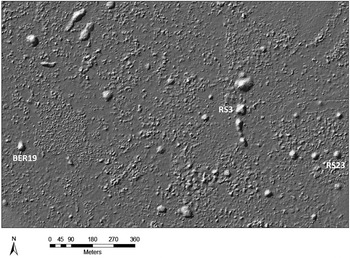
Ground digital elevation model (DEM) derived from light detection and ranging (LiDAR) data from the PACS study area. White indicates higher elevations, the small white dots being archaeological mounds. Labels indicate mound-cluster names. Areas enclosed by white rectangles are shown as groundshade images in Figure 3 (lower right) and Figure 4 (upper left). Image by Neff.

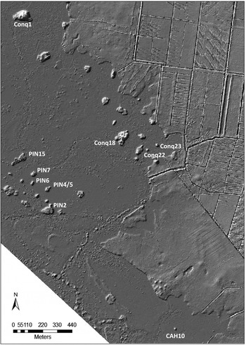
PACS fieldwork took place over the course of four years, from July 2011 through June 2015. After clearing footpaths or water routes to mounds identified on the LiDAR imagery, the initial phase of investigation at most mounds consisted of surface collection and excavation of one to eight shovel test pits. Many mounds were also cleared of vegetation, so that they could be surveyed with a magnetometer and ground-penetrating radar (GPR). The surface collections, shovel tests, and magnetometer/GPR surveys provided a basis for selecting twelve mounds for systematic excavation. Excavations began as 2 × 2, 1 × 2, or 1 × 4 m units, and, in many cases, the excavations were extended in order to expose features encountered in the original excavations. Mounds at which systematic excavations were carried out are labeled in Figures 3 and 4.
Groundshade image derived from light detection and ranging (LiDAR) data for parts of the Rancho Soledad and Bermudez mound clusters. Labeled mounds were sampled with systematic test excavations, as discussed in the text. Image by Neff.

Groundshade image derived from LiDAR data for parts of the Piñuela, Conquista Campesina, and Cahuacan mound clusters. Labeled mounds, except PIN15, were sampled with systematic test excavations, as discussed in the text. Image by Neff.

The surface surveys, shovel tests, and systematic excavations generated various kinds of samples that bear on questions about occupation history central to the PACS project. Most important here are the ceramic collections from stratigraphic tests along with associated charcoal samples for 14C dating. Sediment samples and samples of what appeared to be natural concrete nodules also figure in the discussion presented later on.
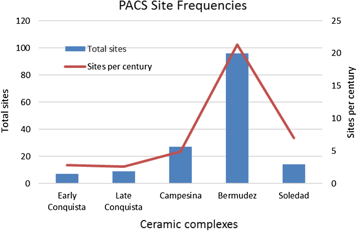
Figure 5 summarizes the Formative-period demographic history of the PACS study area as gleaned from surface collections, shovel tests, and systematic excavations. Five Formative-period ceramic complexes recognized in the area provide a basis for tracking changes in the number of occupied sites through time. Normalized site counts, also shown, differ little in overall trend from the raw site counts. Both indicate initial human settlement during the Early Formative period, with increasing site numbers thereafter, until a dramatic decline during the Terminal Formative. A detailed occupation history of the region appears in the following section.

As part of the focus on landscape-level changes, sediments were also sampled outside of archaeological contexts. Unfortunately, most of the sediment cores from the PACS study area were problematic because of large 14C date reversals, shallow depth, or oxidized/sandy texture. PACS13-2, however, extracted from a salt flat just off the southeastern edge of PIN7 (Figures 1 and 4), showed no radiocarbon-date reversals and mostly fine-textured sediments. Two earlier cores from mangrove contexts in Guatemala (OCC001 and TIL016 in Figure 1) also contain a record of landscape changes relevant to issues addressed here.
OCCUPATION HISTORY OF THE EASTERN SOCONUSCO MANGROVES
Outlines of the ways in which humans utilized the lower-coastal mangrove-estuary zone of the Pacific coast have been known for some time. Humans were exploiting subsistence resources of the estuaries as early as 5500 cal b.c., as indicated by dense accumulations of shell in the Chantuto zone, approximately 50 kilometers north of the PACS study area (Voorhies Reference Voorhies1976, Reference Voorhies2004, Reference Voorhies2015; Voorhies et al. Reference Voorhies, Kennett, Jones and Wake2002). Coastal-plain forest clearance is also detectable during the Archaic period, in sediment cores obtained both north of the PACS study area, in Chiapas (Kennett et al. Reference Kennett, Piperno, Jones, Neff, Voorhies, Walsh and Culleton2010), and south of the study area, in Guatemala (Neff et al. Reference Neff, Pearsall, Jones, Arroyo, Collins and Freidel2006). Early Formative village sites dating between 1800 and 1000 cal b.c. are known from a wide area of the Pacific littoral, from the Isthmus of Tehuantepec to western El Salvador (Arroyo Reference Arroyo1994, Reference Arroyo, Barnett and Hoopes1995; Clark Reference Clark and Fowler1991, Reference Clark1994; Clark and Blake Reference Clark, Blake, Brumfiel and Fox1994; Coe Reference Coe1961; Coe and Flannery Reference Coe and Flannery1967; Lowe Reference Lowe1975; Pailles H. Reference Pailles H.1980; Pye Reference Pye1995; Pye et al. Reference Pye, Hodgson, Clark and Lesure2011; Shook and Hatch Reference Shook and de Hatch1979), and sediment cores from several locations in Guatemala carry a signal of Early Formative land clearance (Neff et al. Reference Neff, Pearsall, Jones, Arroyo, Collins and Freidel2006). Later deposits of the Middle, Late, and Terminal Formative are also documented at a number of locations in or adjacent to the mangrove zone, mainly to the southeast of the PACS study area, in Guatemala (Arroyo Reference Arroyo1994; Bove Reference Bove1989; Coe Reference Coe1961; Coe and Flannery Reference Coe and Flannery1967; Love Reference Love, Love, Hatch and Escobedo2002a, Reference Love2002b, Reference Love2007; Nance Reference Nance1992).
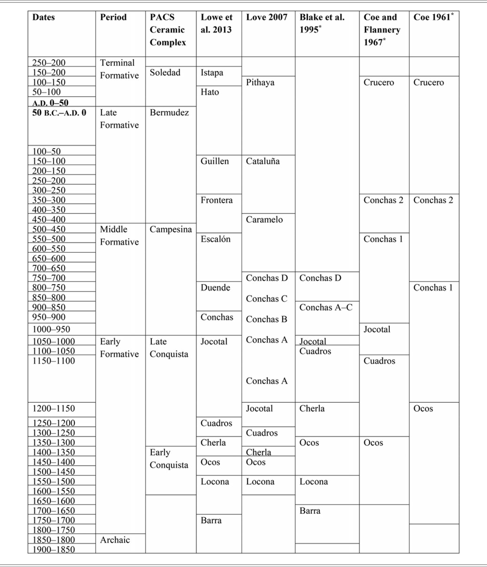
To some extent, the patterns of human impacts documented elsewhere on the Pacific coast are recapitulated within the PACS study area (Table 1). What makes the PACS study area especially interesting is that details for the complete Archaic and Formative sequence can now be filled-in for a zone that lies downstream from and within the sustaining area of a major center of Formative-period growth, Izapa (Figure 1).
Chronological alignment of periods, phases, and complexes discussed in the text.

*Phase boundaries were originally based on uncalibrated radiocarbon dates. Here, start and end dates were obtained by calibrating the original phase boundaries using OxCal 4.2 (Bronk Ramsey Reference Bronk Ramsey2009) using IntCall13 (Reimer et al. Reference Reimer, Bard, Bayliss, Beck, Blackwell, Ramsey, Buck, Cheng, Edwards, Friedrich, Grootes, Guilderson, Haflidason, Hajdas, Hatte, Heaton, Hoffmann, Hogg, Hughen, Kaiser, Kromer, Manning, Niu, Reimer, Richards, Scott, Southon, Staff, Turney and van der Plicht2013). Phase boundaries are adjusted to nearest half-century.
Archaic Period
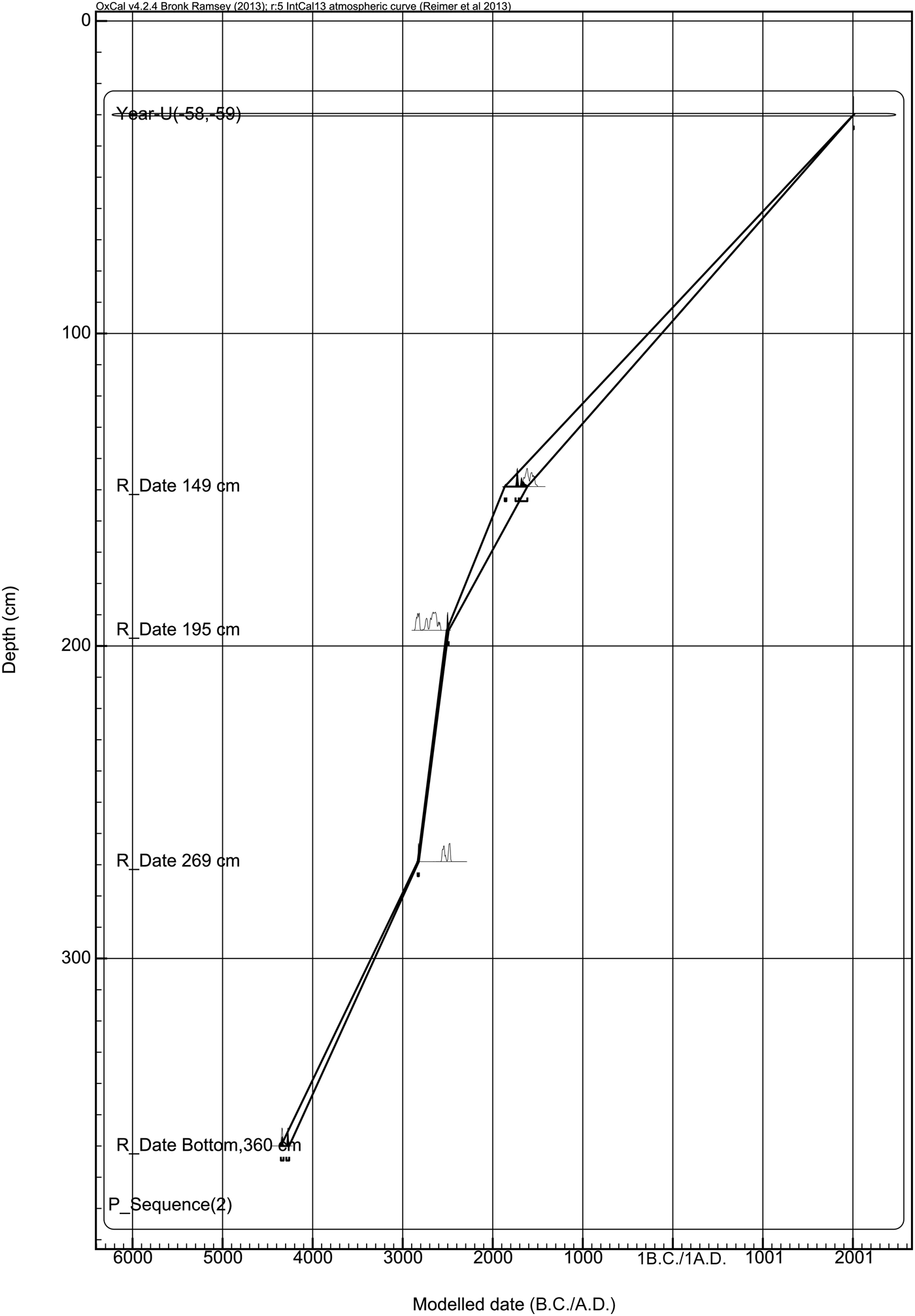
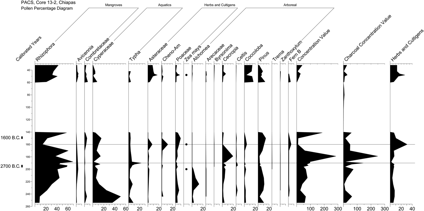
As elsewhere along the Pacific coast, the sedimentary record in the PACS study area shows a clear signal of human impacts during Archaic times. Core PACS13-2 penetrated sediments that extend back more than 6,000 years (Figure 6). Radiocarbon dates at 195 and 269 cm are indistinguishable, indicating that deposition was rapid between 3000 and 2000 cal b.c. Mangroves are dominant in the vicinity of the core during this interval (Figure 7), but terrestrial disturbance species are also present, including maize pollen in near-direct association with a 14C date of 2700 cal b.c. Charcoal is also present during this time interval, with a pronounced spike just above the 2700 cal b.c. date. Consistent with earlier results (Kennett et al. Reference Kennett, Piperno, Jones, Neff, Voorhies, Walsh and Culleton2010; Neff et al. Reference Neff, Pearsall, Jones, Arroyo, Collins and Freidel2006), PACS13-2 shows that Late Archaic people cleared garden plots on the coastal plain, increasing sediment delivery to the littoral zone.
Depth model (Bronk Ramsey Reference Bronk Ramsey2008) fit to the 14C dates from core PACS13-2. Calibration from Oxca. 4.2 (Bronk Ramsey Reference Bronk Ramsey2009) based on IntCal13 (Reimer et al. Reference Reimer, Bard, Bayliss, Beck, Blackwell, Ramsey, Buck, Cheng, Edwards, Friedrich, Grootes, Guilderson, Haflidason, Hajdas, Hatte, Heaton, Hoffmann, Hogg, Hughen, Kaiser, Kromer, Manning, Niu, Reimer, Richards, Scott, Southon, Staff, Turney and van der Plicht2013). Image by Neff.

Pollen percentage diagram from core PACS13-2, obtained from a salt flat approximately 20 meters off the southeast edge of PIN7 (Figure 4). Image by Neff.

Although Late Archaic populations are detectable in the littoral zone sedimentary record, as yet they remain invisible in the archaeological record of eastern Soconusco. Shell middens like those of the Chantuto zone (Voorhies Reference Voorhies2004) are absent within the PACS study area and, while one radiocarbon date calibrates to between 2200 and 2000 b.c., the date was out of stratigraphic order within an Early Formative deposit (see discussion below). Archaic-period sites are also unknown from the coastal plain and piedmont upstream from the PACS study area. Archaic-period populations thus appear to have been mobile, clearing the forest for crops and perhaps to enhance availability of game, but not investing sufficiently in domestic architecture or staying in one place long enough for their presence to be manifested archaeologically. Geomorphological conditions, such as high sedimentation rates and continued sea-level rise after 2000 cal b.c. may also be obscuring the Archaic-period archaeological record both on the coastal plain (Voorhies and Kennett Reference Voorhies and Kennett1995) and within the littoral zone.
Early Formative Period
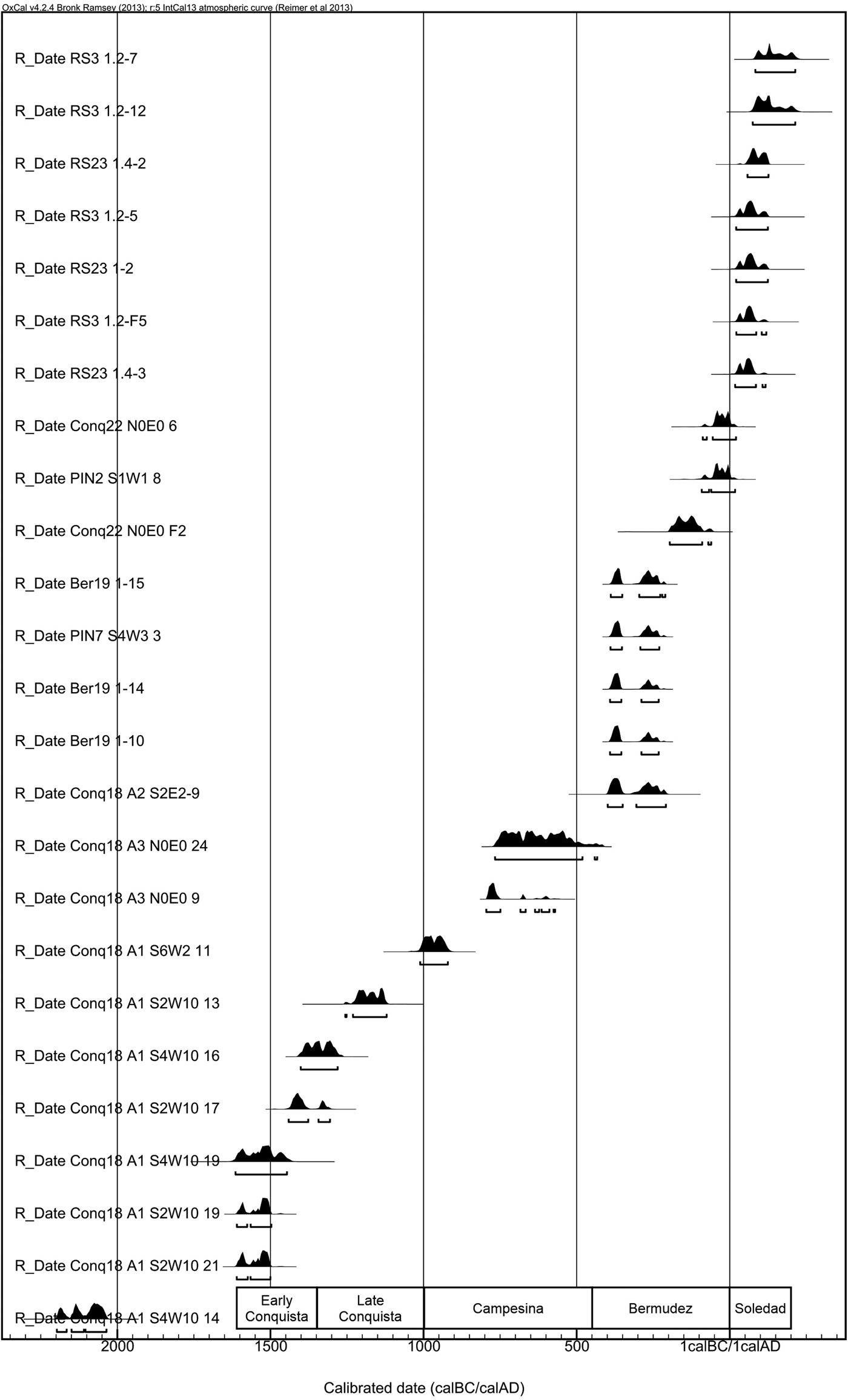
Two ceramic complexes are recognized for the earliest archaeological manifestations within the PACS study area (Burger Reference Burger2015). The Early Conquista complex corresponds to the early part of the Early Formative (Locona and Ocos phases in Table 1), while the Late Conquista complex corresponds to the late Early Formative Cuadros and Jocotal phases. Radiocarbon dates (Figure 8) place the former between about 1600 and 1350 cal b.c. and the latter between 1350 and 1000 cal b.c. The initial Early Formative Barra phase, recognized in the Mazatan region, about 25 kilometers northwest of the study area (Blake et al. Reference Blake, Clark, Voorhies, Michaels, Love, Pye, Demarest and Arroyo1995; Clark Reference Clark1994), so far is not recognizable in any of the PACS ceramic collections, and no 14C dates suggest an occupation beginning at 1800 cal b.c., the early limit assigned to the Barra phase. One 14C date from Conq18 falls between 2200 and 2000 cal b.c. (Figure 8), but this date comes from a relatively pure Late Conquista context and thus is interpreted as old wood that became incorporated into the late Early Formative deposit. Recent excavations by James Daniels (personal communication, 2017) at two Early Formative mounds in the Rancho Soledad mound cluster may have encountered pre-Early Conquista remains, thus pushing back the initial occupation of the PACS area by 100–200 years.
Calibrated 14C dates from Formative-period contexts in the PACS study area. Calibrations obtained from Oxcal 4.2 (Bronk Ramsey Reference Bronk Ramsey2009) using IntCal13 (Reimer et al. Reference Reimer, Bard, Bayliss, Beck, Blackwell, Ramsey, Buck, Cheng, Edwards, Friedrich, Grootes, Guilderson, Haflidason, Hajdas, Hatte, Heaton, Hoffmann, Hogg, Hughen, Kaiser, Kromer, Manning, Niu, Reimer, Richards, Scott, Southon, Staff, Turney and van der Plicht2013). Approximate start and end dates of complexes are at bottom. Image by Neff.

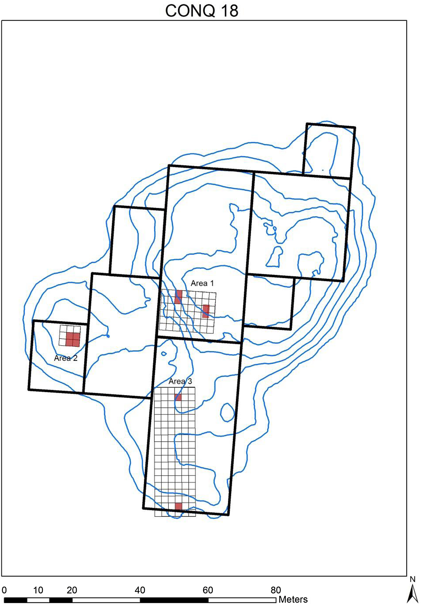
Early Conquista ceramics include many examples of types identified by Coe (Reference Coe1961; Coe and Flannery Reference Coe and Flannery1967) at La Victoria as diagnostic of the Ocos phase (Burger Reference Burger2015). Thin, red-rimmed tecomates predominate, often with specular red paint on the rims. Shallow, fine incising on both red and black surfaces is a common decorative mode. Deposits containing unmixed Early Conquista ceramics were found in the deepest layers of stratigraphic tests in the main platform at Conq18 (northwestern excavation block of Area 1 in Figure 9), which were below the water table but appeared to rest on sterile sediments. Levels immediately above the pure Early Conquista deposits contained a mixture of Early and Late Conquista diagnostics. In the Mazatan zone, Clark (Reference Clark1994), Blake (Blake et al. Reference Blake, Clark, Voorhies, Michaels, Love, Pye, Demarest and Arroyo1995), and their colleagues recognize a transitional phase, Cherla, between Ocos and Cuadros (Table 1), but neither the Conq18 excavation nor any other deposit investigated on the PACS project contained components that could be assigned to such a transitional phase.
Map of Conq18, showing locations of excavations discussed in the text (red shading). Black rectangles are areas covered by geophysical survey (magnetometer and ground-penetrating radar [GPR]). Map by Neff.

The Early Conquista deposits indicate occupation by people who harvested subsistence resources of the littoral zone. The intact, unmixed deposits at the bottom of the Conq18 Area 1 excavations contained domestic debris, such as shell and fish bones, obsidian flakes, and ground stone. The density of these deposits is consistent with the interpretation that they represent relatively long-term habitation by Early Formative villagers.
The broader distribution of Early Conquista occupations also suggests they were habitation sites. Early Conquista sherds were found in surface collections and shovel tests at three sites in the Rancho Soledad mound cluster, one site in the Bermudez mound cluster, and two sites in the Chical cluster (see Figure 2). These five sites are large, conical mounds situated close to the inland edge of the current mangrove forest. Like Conq18, their locations would have afforded access both to estuarine resources and garden plots on the coastal plain inland from the mangroves.
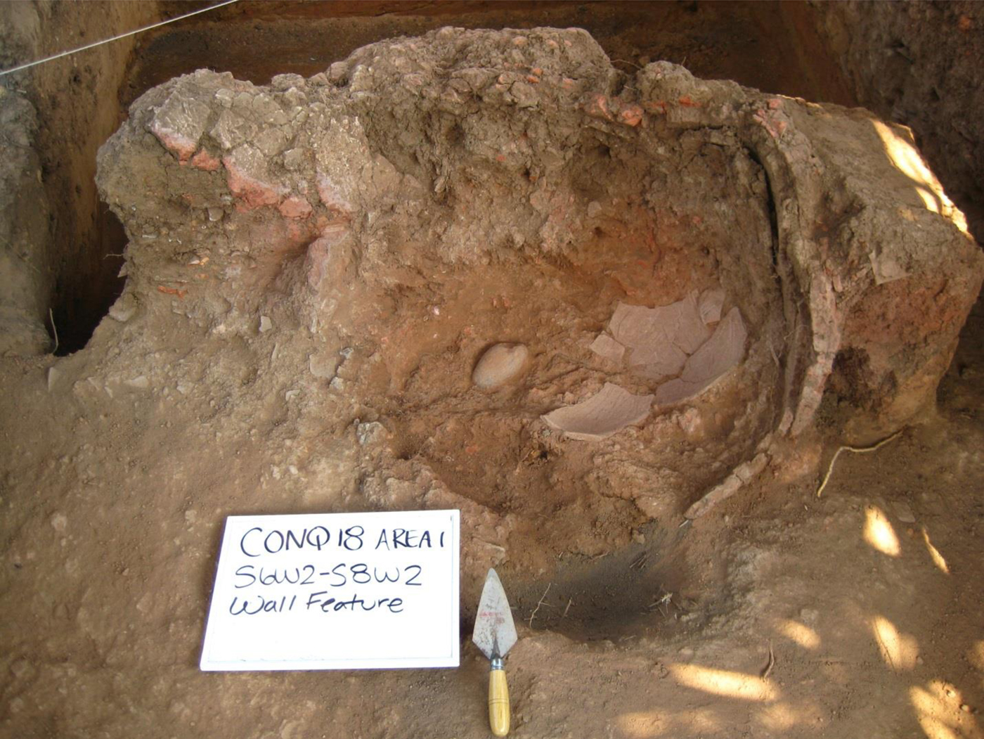
The Late Conquista complex is best known from excavations into the main platform at Conq18 (Area 1 in Figure 9), where it overlies Early Conquista deposits. Surface remains at this site also contain many Late Conquista ceramic diagnostics, and lower levels of excavations into the western and southern peninsulas (Figure 9, Areas 2 and 3) also encountered Late Conquista diagnostics. A notable feature of the Late Conquista deposits in Conq18 Area 1 is the alternating layers of gray-brown and fire-reddened sediments that extend down approximately three meters, roughly to the transition to levels dominated by the Early Conquista complex. The reddish layers appear to have been created by spreading out fire-affected sediment that may have been created by firing in circular pits, such as one found on the top of the Conq18 main platform (Figure 10; this is in the easternmost excavation within Area 1 in Figure 9).
Pit-firing feature from excavation in easternmost excavation in Area 1 of Conq18. A radiocarbon sample came from inside the bottom of this feature. The radiocarbon assay labeled “Conq18 A 1 S6W2 11” in Figure 8 came from inside the bottom of this feature. Photograph by Neff.

The Late Conquista complex is dominated by tecomates of the types Guamuchal Brushed and Suchiate Brushed (Burger Reference Burger2015), defined originally by Coe and Flannery (Reference Coe and Flannery1967), who placed them in the Cuadros and Jocotal phases of Salinas La Blanca. High frequencies of Guamuchal and Suchiate brushed tecomates were also observed in Cuadros and Jocotal assemblages at El Varal (Lesure Reference Lesure and Lesure2009a; Lesure and Wake Reference Lesure, Wake and Lesure2011), about 25 kilometers north of Conq18 (Figure 1).
Within the PACS study area, the Late Conquista complex also dominates deposits sampled by systematic excavation at Conq1, the largest mound encountered anywhere in the PACS study area (Figure 4). Although ceramic collections from the Conq1 excavations have not yet been studied carefully, they appear to show the same dominance of brushed tecomates as Conq18. Late Conquista sherds were also common in the surface collection and shovel test pits elsewhere in the Conquista Campesina mound cluster and at PIN15 (Figure 4). A dense surface scatter of Late Conquista sherds was also noted on the mangrove forest floor about 100 meters northwest of PIN15; this anomalous discovery, one of only a few non-mound archaeological deposits in the entire PACS study area, may have been a small, deflated mound. South of the Rio Cahuacan, Late Conquista diagnostics appear infrequently, mostly in surface collections dominated by Early Conquista diagnostics.
Like the Early Conquista complex, the Late Conquista complex is associated with various kinds of domestic debris, including shell, bone, obsidian flakes, and ground stone. This is consistent with observations at other Cuadros-Jocotal sites, such as Salinas La Blanca (Coe and Flannery Reference Coe and Flannery1967), El Varal (Lesure Reference Lesure and Lesure2009a, Reference Lesure and Lesure2009b; Lesure and Wake Reference Lesure, Wake and Lesure2011), and El Mesak (Pye Reference Pye1995; Pye et al. Reference Pye, Hodgson, Clark and Lesure2011). Lesure (Reference Lesure and Lesure2009a, Reference Lesure and Lesure2009b; Lesure and Wake Reference Lesure, Wake and Lesure2011) argues that El Varal was a habitation site, but that it was occupied for only part of the year by people who harvested estuarine resources and produced salt during the dry season. At El Mesak, in contrast, the Jocotal-phase mound, which contains floors, postholes, hearths, and storage pits, is argued to represent year-round occupation by specialist salt producers who also harvested subsistence resources of the estuary (Pye et al. Reference Pye, Hodgson, Clark and Lesure2011). Contrasting interpretations of these two Jocotal occupations may arise from the fact that the late Early Formative period was a time of variability and transition, as Lesure and Wake (Reference Lesure, Wake and Lesure2011) argue. Subsequent littoral-zone developments, discussed next, suggest that the mangrove forest was on its way to becoming a highly specialized pyro-industrial zone exploited by non-resident populations who provided crucial goods for interior populations.
Middle Formative Period
The Middle Formative Campesina complex corresponds to the Conchas phase of La Blanca (Love Reference Love2002b) and the Conchas, Duende, and Escalon phases of Izapa (Lowe et al. Reference Lowe, Ekholm and Clark2013). Three associated 14C dates span a range from approximately 1000 to 450 cal b.c. (Figure 8). The earliest date, from Conq18 Area 1, is from inside a circular firing feature (Figure 10) on the top of the main platform (easternmost excavation within Conq18 Area 1 in Figure 9). As discussed above, the Area 1 deposits are mostly Early Formative, this feature representing a relatively late event in the history of the main platform. The two later Campesina complex dates are associated with circular firing features in the northernmost excavation in Conq18 Area 3 (Figure 9). Because of a flat section of the 14C calibration curve, these two dates have very long 2-sigma calibrated ranges, but they certainly postdate 800 cal b.c.
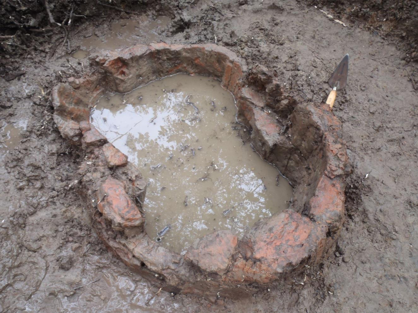
The Conq18 Area 3 firing features are associated with dense concentrations of large, coarse-textured ceramics designated Campesina Brown Coarse by Burger (Reference Burger2015). These hemispherical vessels have direct rims and a distinct thickening of the vessel wall that appears as a step on the exterior about six centimeters below the rim. Rim diameters are estimated at 45–55 centimeters. Association of these vessels with pit-firing features was confirmed by chance discovery of an identical firing pit on the floor of the mangrove forest just off the northern edge of PIN15 (Figure 4). This feature (Figure 11) consists of thick fired-clay walls that are hour-glass shaped in plan, the width at the constriction being less than the rim diameter of Campesina Brown Coarse sherds that filled the interior of the pit. The vessels, with their thickened bases, appear to have been designed to rest on the constricted portion of the firing pit, leaving access from the sides to add fuel to a fire underneath the vessel. This firing feature is well-designed to maintain constant heat, as would be required for production of salt by the sal cocida technique.
Pit-firing feature found on the mangrove-forest floor about five meters off the northern peninsula of PIN15 (see Figure 4). Walls were protruding above the forest floor when found. Cleaning of the interior recovered numerous sherds of Campesina Brown Coarse pottery, as discussed in the text. Photograph by Neff.

The sal cocida technique was widespread during historic times along the Pacific Coast according to Andrews (Reference Andrews1983), McBryde (Reference McBryde1945), Coe and Flannery (Reference Coe and Flannery1967), and others. According to these accounts, large colanders, sometimes made of old canoes, were used to leach brine out of salt-flat sediment. The brine was then boiled slowly in large ceramic ollas to form salt cakes. As noted above, Pye (Reference Pye1995; Pye et al. Reference Pye, Hodgson, Clark and Lesure2011) infers that specialized sal cocida salt production had begun at El Mesak by Jocotal times. The putative salt containers used in this case were exceptionally abundant, crude, tall, narrow, open jars called Mesak Jars (Pye Reference Pye1995). Arroyo (Reference Arroyo, Lohse and Valdez2004; Arroyo et al. Reference Arroyo, Neff, Features, Love, de Hatch and Escobedo2002) identified very similar vessels, designated Manglera, at late Early Formative sites along the coast further southeast in Guatemala. North of El Mesak, at El Varal and Conq18, specialized salt containers are absent during the late Early Formative, but the nature of late Early Formative deposits, especially the firing pits and abundant fire-reddened sediments, leads us, like Lesure and Wake (Reference Lesure, Wake and Lesure2011), to believe that salt was a dry-season focus of the late Early Formative mangrove-zone inhabitants.
The Middle Formative Campesina complex represents an improvement in salt-production technology over the more generalized, tecomate-based technology of the Late Conquista complex. Firing pits and large-orifice ceramic brine-boiling vessels were designed to work together efficiently, extracting salt with lower expenditure of labor and fuel. Lesure and Wake (Reference Lesure, Wake and Lesure2011) hypothesize a lack of strong selection on salt-vessel forms during Jocotal times, which permitted use of tecomates in some locations (El Varal and Conq18) and more appropriate, open forms elsewhere (El Mesak). Results from the PACS study area indicate that, by the Middle Formative, selective pressures on salt-production technology had become stronger, and had created a more efficient tool kit.
Since Campesina Brown Coarse vessels are components of a specialized salt-production tool kit, it is unsurprising that they are not found at the inland Middle Formative centers of Izapa and La Blanca. Correspondingly, diagnostic serving vessels of the Conchas, Duende, or Escalon phases (see Table 1) are rare or absent in the PACS study area. The divergence in ceramic assemblages reflects the increasing functional divergence between mangrove-zone production sites and interior political centers.
Although a few Campesina-complex diagnostics were identified in surface collections and shovel tests within the Chical, Bermudez, and Rancho Soledad mound clusters, the extremely dense Late Formative (Bermudez complex) deposits of these areas probably obscure the early stages of the Middle Formative salt industry in most parts of the PACS study area. Based on the PIN15 firing feature, many of these specialized features may have been constructed initially not on pre-existing mounds but at the level of the forest floor, so that most may be concealed beneath later debris. As shown by the Conq18 Area 3 excavations, deep deposits of superimposed firing features accumulated rapidly during the Middle Formative, and this process continued into the Late Formative, as discussed further below. If Campesina-complex remains are partially obscured by deep burial, the Campesina-complex site frequency shown in Figure 5 is an underestimate.
Late Formative Period
Radiocarbon dates for the Late Formative Bermudez complex fall between about 450 cal b.c. and cal a.d. 0 (Figure 8). The complex is almost ubiquitous in the PACS study area, surface collections and shovel tests having encountered Bermudez at 96 of the total 132 mounds visited (Figure 5). The excavated assemblage from BER19 (Figure 3) was pure Bermudez, and Conq18, Conq22, Conq23, PIN7, PIN4, PIN2, and PIN6 (Figure 4) all had Bermudez stratified under Terminal Classic (La Gloria complex) remains. CAH10 (Figure 4) had Bermudez at the bottom of a deposit that extended from Middle through Terminal Classic. The near ubiquity of Bermudez in surface collections, shovel-test, and systematic excavations strongly suggests a peak in human use of the estuary zone during the Late Formative.
Large, moderately well-made, open forms with reddish surface and paste are the main components of the Bermudez ceramic assemblage. These include most vessels in Burger's (Reference Burger2015) Bermudez Plain Group together with 86% of Decorated Group types Bermudez Brown on Brown Ribbed, Red on Red Ribbed, and Red on Brown Ribbed. These are similar to some of Love's (personal communication, 2012) Late and Terminal Preclassic types (Cataluña and Pithaya phases in Table 1) from Ujuxte. Coe and Flannery (Reference Coe and Flannery1967) also illustrate ribbed basins assigned to the Crucero phase that appear to be similar to the Bermudez-complex vessels. Lowe et al. (Reference Lowe, Ekholm and Clark2013; also see Lowe et al. Reference Lowe, Lee and Martinez E.1982) describe ribbed, red-slipped basins at Izapa, designated Tuzantan Red-Slipped and assigned to the Guillen phase (Late Preclassic), that seem similar to Bermudez-complex diagnostics, although the paste colors are distinct.
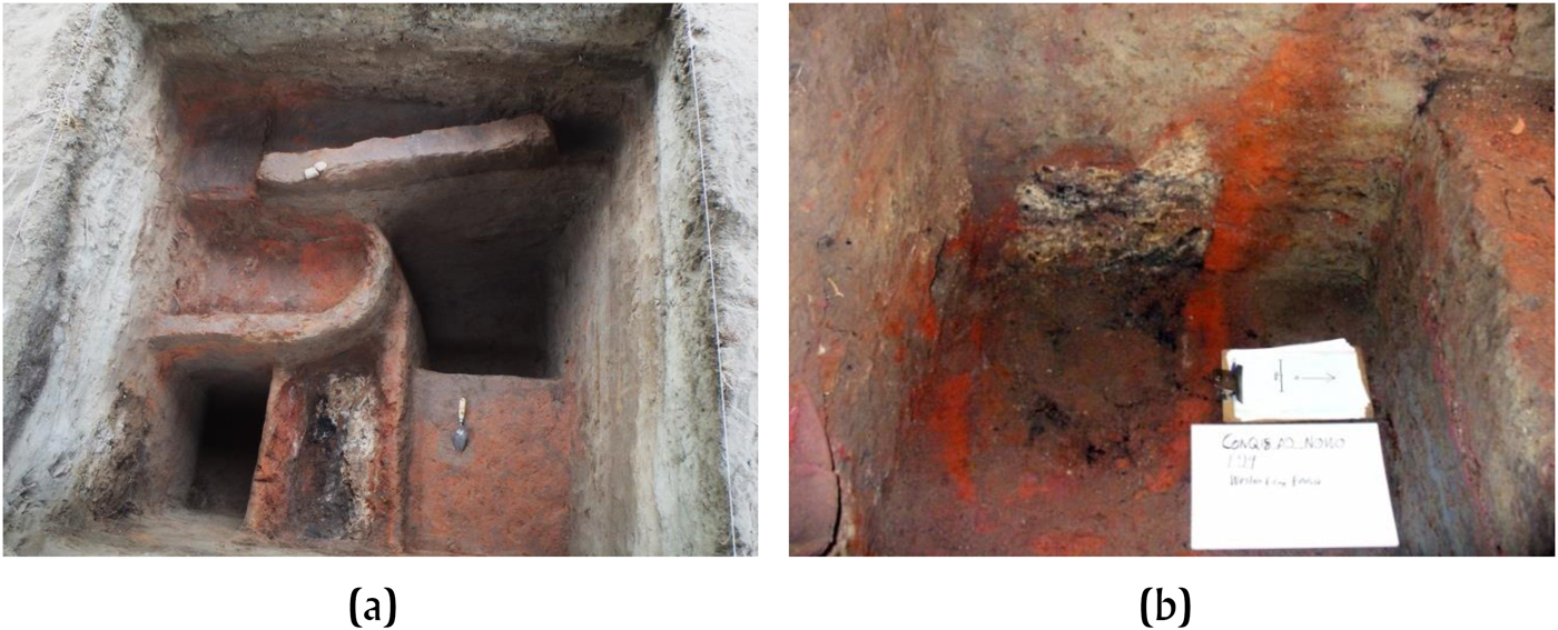
Based on excavations at Conq18 Area 2, Conq22, Conq23, PIN7, and Ber19 together with observations in shovel tests at many other sites, Bermudez-complex remains are strongly associated with pyro-technological activity (Figure 12). At the bottom of Conq18 Area 2 and at Conq23, the firing features are circular ash- and charcoal-filled pits similar to the earlier Middle Formative pits encountered in Conq18 Area 3 and described above. At PIN7, the core of the mound consists of superimposed, fire-reddened walls and troughs (Figure 12a); a fire-reddened wall and associated floor was also found at the bottom of the Conq22 excavation. At Ber19, a pure Bermudez deposit, mineralogical (Fourier-transform infrared spectroscopy [FTIR]) and elemental (x-ray fluorescence [XRF]) analysis of sediments show a strong signal of exposure to heat of the clay minerals together with admixture of ash-calcite into the sediments, both signals increasing markedly at about one meter depth in the excavation (Neff et al. Reference Neff, Bigney, Sakai, Burger, Garfin, George, Culleton and Kennett2016). Thus, very many, if not most, of the mounds in the PACS study area are formed by a core of firing features and fire-affected sediments accumulated during the Late Formative period.
Firing features in Bermudez Complex deposits. (a) PIN7 S14W2, view from top north side, looking south. (b) Conq18 Area 2, N0W0, inside bottom of unit, looking west. Photographs by Neff.

Low frequencies of shell, bone, obsidian, and ground stone relative to the extremely dense ceramics in Bermudez-complex deposits preclude interpreting them as habitation sites. Instead, both the ceramic inventory and characteristics of the deposits themselves are consistent with intensive pyro-industrial activity. Production of salt by the sal cocida technique, argued to have begun during the Early Formative period (Lesure and Wake Reference Lesure, Wake and Lesure2011; Pye Reference Pye1995; Pye et al. Reference Pye, Hodgson, Clark and Lesure2011) and to have become more specialized during the Middle Formative (see above) is the most likely activity undertaken at these mounds.
A possible objection to the hypothesis of intensive salt production during the Late Formative is that the Bermudez-complex vessels, while open and thus suitable for efficient evaporation of brine, are better made than vessels attributed to the sal cocida technology elsewhere. At Jocotal-phase El Mesak, Pye (Reference Pye1995; Pye et al. Reference Pye, Hodgson, Clark and Lesure2011) identifies the extremely crude Mesak Jars (called Manglera by Arroyo [Reference Arroyo, Lohse and Valdez2004]) as adaptations for production of salt cakes. Similarly, the Porvenir Coarse vessels attributed by Nance (Reference Nance1992) to salt production, like the El Gancho Coarse described below for the Soledad complex, are extremely crude, as if made for a single use. If the Bermudez vessels were designed for multiple salt-production episodes, however, greater investment in their production (and consequent better quality) would make sense. Evidence in favor of this hypothesis includes micro-archaeological comparison of the BER19 deposits with the Soledad-complex deposits at RS3 and RS23 (Neff et al. Reference Neff, Bigney, Sakai, Burger, Garfin, George, Culleton and Kennett2016), which is discussed below.
Terminal Formative
Radiocarbon dates for the Terminal Formative Soledad complex fall between approximately cal a.d. 0 and 250 (Figure 8). All seven dates for this complex come from excavations at two sites in the Rancho Soledad mound cluster, RS3 and RS23 (Figure 3). Surface collections and shovel testing encountered Soledad remains elsewhere in the Rancho Soledad cluster, but it does not occur elsewhere in the PACS study area. Thus, the Terminal Formative appears to represent a decline in human activity within the estuary zone compared to the Late Formative peak (Figure 5).
The Soledad-complex deposits in the PACS study area appear to be very similar to the Guzman Mound deposits excavated by Nance (Reference Nance1992) in neighboring Guatemala (near Salinas La Blanca in Figure 1). Like the Guzman Mound, the RS3 and RS23 deposits contain large quantities of crude, constricted-neck vessels designated Porvenir Coarse by Nance (Reference Nance1992) and El Gancho Coarse on the PACS project (Burger Reference Burger2015). The Soledad complex also includes other Terminal Formative diagnostics, such as red-rimmed Usulutan (Burger Reference Burger2015).
As mentioned above, Nance (Reference Nance1992) interprets the Guzman Mound as a sal cocida salt-production facility. This interpretation is based on functional attributes of the Porvenir Coarse vessels that dominate the assemblage, fire reddening of the sedimentary matrix, and the very low frequencies relative to ceramics of shell, bone, obsidian, and ground stone. Similar considerations underlie our interpretation of the RS3 and RS23 deposits: in addition to containing the same coarse pottery, neither deposit contained any shell, bone, or obsidian whatsoever, and each yielded only a single ground stone fragment.
The RS3 and RS23 sedimentary matrix in which cultural material is embedded is also fire reddened, like the Guzman Mound. Moreover, FTIR spectroscopy confirms that sediments from all excavation levels were exposed to temperatures in excess of 500° C (Neff et al. Reference Neff, Bigney, Sakai, Burger, Garfin, George, Culleton and Kennett2016). Additionally, concrete nodules that make up a major component of the deposits were confirmed by FTIR to be made up of a calcite-silicate mixture, i.e., concrete. Since there are no shells in the deposits and no limestone geological formations outcrop in eastern Soconusco, the concretions are most parsimoniously interpreted as the result of mixing of ash calcite generated by pyro-technological activity with silicates and water in the sedimentary matrix. Sherds were embedded in some of these nodules, confirming that they formed during cultural activity.
Microarchaeological study of the Ber19, RS3, and RS23 deposits (Neff et al. Reference Neff, Bigney, Sakai, Burger, Garfin, George, Culleton and Kennett2016) confirms that all three resulted from pyro-technological activity but also suggests some differences in formation processes between the Late Formative Bermudez deposits (Ber19) and the Terminal Formative Soledad deposits (RS3 and RS23). Whereas ash calcite (identified by FTIR) is concentrated in discrete layers and tends to occur in nodules at RS3 and RS23, it is well-mixed and uniformly high, especially in the intact deposits below one meter depth, at Ber19. Elemental calcium determined by XRF shows a very similar pattern to the FTIR indicators.
Formative-Period Anthropogenic Impacts in the PACS Study Area
Variable but generally increasing intensity of Formative-period exploitation of the mangrove zone, summarized above, must have impacted geomorphological, hydrological, and ecological characteristics of the zone. The PACS data provide some basis for inferring the nature of those impacts.
As noted previously, increased delivery of sediment to the lower coast as a result of coastal-plain forest clearance probably contributed to growth of the mangrove zone during Late Archaic times, leading to dominance of mangroves at the location of core PACS13-2 between 3000 and 1600 cal b.c. (Figures 6 and 7). Mangroves remain dominant, maize pollen is present, and pollen concentrations are still high in a sample from 140 cm depth, which dates to roughly 1400 cal b.c. based on the depth model (Figure 6). This is when Early Formative habitation sites such as Conq18 Area 1 were becoming established. Immediately above 140 cm, however, there is a ~90-centimeter layer of oxidized sediments that are devoid of pollen. The depth model (Figure 6) suggests that this ~90-cm layer was deposited between approximately 1400 cal b.c. and cal a.d. 1100. Thus, conditions appear to have changed dramatically soon after 1400 cal b.c., such that pollen was not preserved for the remainder of the Formative period and into Classic-period times. Core TIL016, in neighboring Guatemala (Figure 1), is similar to PACS13-2 in that it shows mangroves persisting along with disturbance indicators and maize pollen from Late Archaic into Early Formative times, then a hiatus in pollen deposition from approximately 1000 cal b.c. through cal a.d. 850 (Neff et al. Reference Neff, Pearsall, Jones, Arroyo, Collins and Freidel2006:Figure 9).
The layers devoid of pollen in PACS13-2 and TIL016 indicate periodic desiccation of the sediments, such that pollen and other organics were not preserved. Such conditions imply deforestation of the mangroves. This inference is consistent with the archaeological record of intensive pyro-technological activity beginning in late Early Formative times and peaking in the Late Formative. That is, intensive harvesting of the mangrove forest for fuel, which began around 1000 cal b.c., led in some locations to deforestation severe enough to leave sterile layers in the sedimentary record.
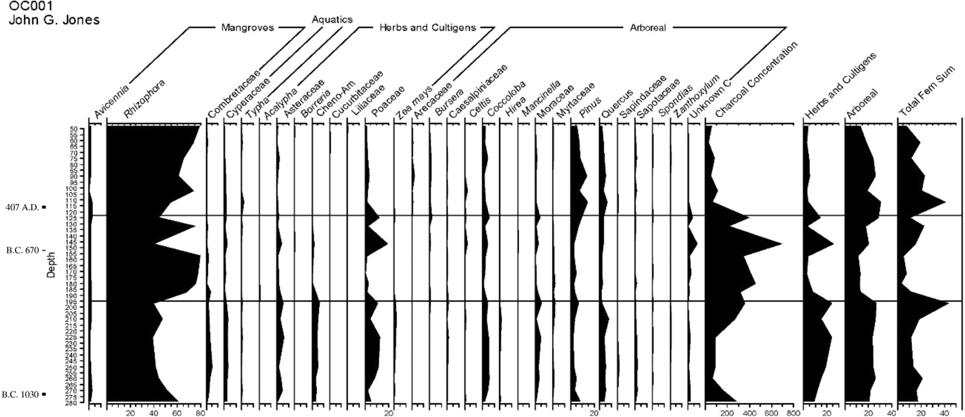
Core OC001 (Figure 13), also from the lower coast of southwest Guatemala (Figure 1), does not contain desiccated layers, but it too provides some support for the mangrove deforestation hypothesis. Mangroves are dominant throughout the core, but they are lowest (around 40 percent of total pollen) in basal layers, which date to between 1000 and 750 cal b.c. These basal layers, which are contemporaneous with the florescence of the Conchas-phase center of La Blanca (Love Reference Love2002b, Reference Love2007) and the nearby Conchas-phase occupation of La Victoria (Coe Reference Coe1961), also show high disturbance indicators and maize. Charcoal is also present in the basal layers but shows a marked rise after 800 cal b.c. and a peak at about 450 cal b.c. Interestingly, disturbance indicators and maize, which normally correlate well with charcoal concentration in Pacific coastal cores, decline at about 750 cal b.c., when charcoal is still increasing. Thus, the charcoal in core OC001 may not be purely a signal of coastal-plain agricultural clearance but also partly a signal of fuel-wood consumption within the mangrove zone. The record of high charcoal accumulation in OC001 extends from the Middle Formative through the Late and Terminal Formative, as does the evidence for intensive sal cocida salt production as summarized above. According to this interpretation, the fact that mangroves remain dominant at OC001 during a time when charcoal concentrations were high indicates that the immediate vicinity of the core was not being exploited for mangrove-wood fuel and that the charcoal was coming partly from fires in nearby areas, such as the PACS study area to the northwest or the Salinas La Blanca and Guzman Mound area to the east.
Pollen percentage diagram from Core OC001, obtained about 300 meters southwest of La Victoria (Figure 1) in 2000. This diagram previously published by Neff et al. (Reference Neff, Pearsall, Jones, Arroyo, Collins and Freidel2006:Figure 10). Image by Neff.

Another Formative-period anthropogenic impact worth mentioning was the addition of topographic relief to the otherwise flat, swampy mangrove-estuary zone. The LiDAR imagery (Figures 2–4) shows the large number of mounds in the study area, virtually 100 percent of which are human habitation and production sites. Archaeological work indicates that these mounds began to accumulate during the Early and Middle Formative period, and that most of their growth in number and size took place during the Late Formative. These high spots on the landscape provided places for the activities of later people and currently provide islands of biological diversity within the mangrove ecosystem.
DISCUSSION
Based on the evidence summarized above, occupation of the PACS study area began abruptly, around 1600 cal b.c., when villagers who favored thin, red-rimmed tecomates began to occupy single locations that quickly grew into the large, conical mounds where Early Conquista-complex remains are found. Similar wetland-focused early village sites are widespread along the Pacific coast, from Mazatan (Blake et al. Reference Blake, Clark, Voorhies, Michaels, Love, Pye, Demarest and Arroyo1995; Clark Reference Clark1994; Lesure Reference Lesure2009c; Lesure and Wake Reference Lesure, Wake and Lesure2011) and the lower coast of southwest Guatemala (Coe Reference Coe1961; Coe and Flannery Reference Coe and Flannery1967; Love Reference Love2002b) to the central coast of Guatemala and western Pacific El Salvador (Arroyo Reference Arroyo1994, Reference Arroyo, Barnett and Hoopes1995, Reference Arroyo2000, Reference Arroyo, Lohse and Valdez2004; Morgan Reference Morgan and Lesure2011).
What adaptive shifts led to the spread of Early Formative villages around 1600 cal b.c.? Neff et al. (Reference Neff, Pearsall, Jones, Arroyo, Collins and Freidel2006) point to the emergence of a productive subsistence system that coupled technological improvements in estuarine-resource extraction with horticultural production on the coastal plain. Lesure and Wake (Reference Lesure, Wake and Lesure2011) make a complementary argument that invention of more efficient food preparation technology, namely the neckless jar or tecomate, may also have contributed to the success of the Early Formative adaptation. The growing body of evidence from lower coastal sediment cores, such as PACS13-2 and TIL016, leads us to propose that a third, complementary perspective needs to be considered: increased erosion resulting from coastal plain forest clearance and consequent increased sediment delivery to the littoral zone may have contributed to expansion of mangroves, thus helping to create a productive lower-coastal environment that could be colonized by early settled villagers who still lacked sufficiently productive agricultural staples to permit sedentary residence without supplementation from estuarine-resource exploitation. In effect, we hypothesize that Late Archaic horticultural practices helped create a lower-coastal ecosystem capable of supporting the larger, archaeologically visible populations of the Early Formative.
Beyond the estuarine zone, Early Formative remains are also present on the coastal plain just inland from the mangroves. The most prominent example is Mazatan (Figure 1), where villages appeared on the coastal plain during the Barra and Locona phases (Clark Reference Clark1994; Pye et al. Reference Pye, Hodgson, Clark and Lesure2011). Closer to the PACS study area, Rosenswig (Reference Rosenswig2008, Reference Rosenswig and Lesure2011) documents coastal plain contexts of the Barra and Locona phases at Cuauhtemoc (Figure 1), while Love (Reference Love2002b) reports several Locona-Ocos sites just east of the Rio Suchiate. Further inland, at Izapa, mound fill includes a few sherds (five) assignable to the Barra phase (1800–1600 cal b.c.), along with more substantial numbers of Locona- and Ocos-phase sherds (Clark and Lowe Reference Clark, Lowe, Lowe, Ekholm and Clark2013:70). Thus, while initial Early Formative occupation was focused within and adjacent to the mangrove-estuary zone, pottery-using villagers had begun to settle inland as far as the piedmont by 1600 cal b.c.
Occupation intensity increased both in the mangrove zone and further inland during late Early Formative times. In the PACS study area, Late Conquista-complex deposits are widespread and form the largest mounds of the area (Conq1 and Conq18 in Figure 4). In the Mazatan zone, an Olmec colony was established at Canton Corralito around 1400 cal b.c. (Cheetham Reference Cheetham2010) and the Jocotal phase saw a dramatic increase in overall occupation, with an especially large center established at Ojo de Agua (Pye et al. Reference Pye, Hodgson, Clark and Lesure2011). The coastal plain inland from the PACS study area (the Cuauhtemoc coastal plain survey in Figure 1) also shows increased site density during Jocotal times (Rosenswig Reference Rosenswig2008, Reference Rosenswig and Lesure2011). At Izapa, Cuadros and Jocotal sherds are much more common in mound fill than earlier Locona and Ocos sherds (Lowe et al. Reference Lowe, Lee and Martinez E.1982, Reference Lowe, Ekholm and Clark2013). Only the low-hills area surveyed by Rosenswig et al. (Reference Rosenswig, Mendelsohn, Antonelli, Lieske and Cortés2014, Reference Rosenswig, López-Torrijos and Antonelli2015; see Figure 1) shows no clear increase in site density during Cuadros or Jocotal times.
Regional population growth at the end of the Early Formative preceded and may be implicated causally in a shift toward functional differentiation among ecological zones of eastern Soconusco. The evidence for this shift is the contrast between Late Conquista deposits, which contain domestic debris, and Campesina deposits, which contain little or no domestic debris and instead are dominated by a special salt-production tool kit (Figure 11). This evidence indicates that, sometime between approximately 1000 and 800 cal b.c., human use of the mangroves changed from harvesting subsistence resources along with production of salt (as argued by Lesure and Wake Reference Lesure, Wake and Lesure2011) to an exclusive concentration on salt production.
Growing regional population would have selected for the emergence of specialized production within the mangrove zone in two ways. First, a growing interior population increasingly dependent on agriculture would have created growing demand for dietary salt supplements, thus creating an opportunity for people positioned to fulfill the demand. Second, overexploitation of resources by the large late Early Formative population would have reduced local subsistence opportunities for mangrove dwellers. The farming population that needed salt included the Conchas phase people of La Blanca (Love Reference Love2002b; Love and Guernsey Reference Love, Guernsey and Lesure2011) and the Cuauhtemoc zone (Rosenswig Reference Rosenswig and Lesure2011) as well as the Conchas, Duende, and Escalon people of Izapa (Lowe et al. Reference Lowe, Ekholm and Clark2013; Lowe et al. Reference Lowe, Lee and Martinez E.1982). This evolutionary process played out among late Early Formative estuarine populations; evidence includes the fact that the two locations where Middle Formative salt installations have been found (Conq18 Area 3 and PIN15) also have abundant Late Conquista remains. Our hypothesis here is that a specialist salt-producer niche was created by selection originating in demographic and anthropogenic environmental changes at the beginning of the Middle Formative period.
Specialized pyro-industrial activity in the mangrove zone mushroomed during the Late Formative, as shown by ubiquity and density of Bermudez-complex remains in the PACS study area. In contrast to the estuary zone, the adjacent coastal plain was almost abandoned during the Late Formative, judging from the Cuauhtemoc coastal plain survey (Rosenswig Reference Rosenswig2008), and La Blanca also declined in importance (Love Reference Love2002b). There was no widespread regional abandonment, since Ujuxte, further east on the coastal plain (Figure 1), rose to prominence during the Late Formative (Love Reference Love, Love, Hatch and Escobedo2002a, Reference Love2007). Likewise, on the piedmont upstream from the PACS study area, Izapa went through a major Late Formative growth spurt that culminated in the Guillen-phase apogee, when population was at a maximum and most of the sculptural corpus was probably carved (Clark and Lowe Reference Clark, Lowe, Lowe, Ekholm and Clark2013). Late Formative demographic trends on the lower coast are thus coordinated with Izapa, the mangrove-estuary zone serving as a specialized industrial zone for the larger eastern Soconusco region centered on Izapa.
Based on microarchaeological study of one Bermudez-complex deposit (Ber19) and the nature of the artifactual assemblage, Late Formative industrial sites are argued to have been used continuously and intensively (Neff et al. Reference Neff, Bigney, Sakai, Burger, Garfin, George, Culleton and Kennett2016). Such a pattern is consistent with stability and sustained high output by a Late Formative salt industry that supplied salt needed by the piedmont agricultural population centered at Izapa. The sedimentary record, which shows persistent or repeated desiccation throughout the Formative period (PACS13-2 and TIL016) or sustained high charcoal deposition from Middle into Late Formative times (OC001), also accords with the hypothesis of sustained high consumption of fuel wood for salt production.
Terminal Formative salt production departed from the Late Formative pattern of sustained high output. The micro-archaeology of RS3 and RS23 (Neff et al. Reference Neff, Bigney, Sakai, Burger, Garfin, George, Culleton and Kennett2016) together with the exceptionally crude salt-production assemblages at these sites and the Guzman Mound (Nance Reference Nance1992) are consistent with periodic use by producers who made salt-evaporation vessels on the spot, for a single production episode. The shift from Late Formative sustained production to Terminal Formative episodic production suggests diminished demand for salt, presumably as a result of demographic contraction among the interior agricultural populace. This Terminal Formative contraction is part of a widespread collapse that affected the Pacific coast and adjacent highlands between approximately cal a.d. 100 and 250 (Clark and Lowe Reference Clark, Lowe, Lowe, Ekholm and Clark2013; Love Reference Love2007). Although the Classic-period occupation history of the PACS study area is beyond the scope of this paper, it is worth mentioning that only one small site (CAH10 in Figure 4) has a deposit assignable to the interval between cal a.d. 250 and 800.
CONCLUSION
The emergence of complexity, whether in multi-cellular organisms, eusocial insect societies, or complex human societies, entails a shift from functional redundancy to functional differentiation and specialization. In the case of complex human society in eastern Soconusco, an outline of how, when, and why this shift occurred is now taking shape.
Functional redundancy characterized Archaic-period forager-horticulturalists as well as the people who colonized the mangroves during the Early Formative period. The abundance and diversity of domestic debris in Early Conquista contexts (e.g., Conq18 Area 1) supports this inference. It also accords with evidence from nearby Early Formative sites such as La Victoria (Coe Reference Coe1961) and Cuauhtemoc (Rosenswig Reference Rosenswig and Lesure2011). Late Early Formative sites also appear to be residential (Coe and Flannery Reference Coe and Flannery1967; Lesure Reference Lesure2009c): despite differences in ceramic assemblages compared to inland sites (tecomate- versus dish-dominance), Lesure and Wake (Reference Lesure, Wake and Lesure2011) interpret the site of El Varal to be a Cuadros-Jocotal dry-season camp for groups that moved seasonally between interior and mangrove locations. The Conq18 and Conq1 deposits are consistent with this interpretation. Thus, within eastern Soconusco, there is no evidence of functional differentiation up through the end of the Early Formative period, approximately 1000 cal b.c.
A specialized salt-production tool kit and near absence of domestic debris signals a shift to specialized production within the mangrove zone at the beginning of the Middle Formative. Elsewhere in eastern Soconusco, monumentality, the specialty of political aspirants, emerged roughly at the same time at La Blanca (Love Reference Love2002b; Love and Guernsey Reference Love, Guernsey and Lesure2011), with Izapa eclipsing La Blanca as a political-ritual center sometime after 800 cal b.c. (Clark and Lowe Reference Clark, Lowe, Lowe, Ekholm and Clark2013; Pye et al. Reference Pye, Hodgson, Clark and Lesure2011). Contrasts between the ceramic inventories at littoral zone sites and interior political-ritual centers highlight the patterns of functional differentiation that emerged at this time. Other kinds of functional specialization were certainly present, but they are not as easily recognized archaeologically. To summarize, at the level of the region (eastern Soconusco), pyro-industrial specialization (salt and possibly ceramics) arose as a specialty of the lower-coastal zone, where fuel wood was abundant and subsistence opportunities were limited, while interior populations specialized in agricultural production and political ritual. Complex society persisted in eastern Soconusco for approximately 1,000 years, the littoral zone continuing to provide salt for the burgeoning agricultural population until demographic contraction began to affect the region during the Terminal Formative period, roughly cal a.d. 100–250.
RESUMEN
La zona de manglares y esteros al sur de Izapa contiene un registro de actividades humanas durante tiempos arcaicos y formativos, que ha sido investigado recientemente por el Proyecto Arqueológico Costa del Soconusco (PACS). No se encuentran contextos arqueológicos del arcaico, pero el registro sedimentario contiene evidencia que poblaciones de la planicie costera cortaban el bosque tropical durante estos tiempos, lo que aumentaba el abastecimiento de sedimentos a los esteros, contribuyendo a una expansión del área de mangle. Pobladores del formativo temprano colonizaban la zona alrededor de 1600 a.C. (calibrada), y sus números crecían durante la segunda mitad del formativo temprano. Condiciones ambientales y demográficas favorecían un cambio hacía el uso especializado de la zona alrededor de 1000 a.C. (calibrada), cuando instalaciones de carácter piro-industrial se encuentran dentro de áreas utilizadas anteriormente por poblaciones del formativo temprano. El producto más probable de estas fábricas era sal, que necesitaban los pobladores agrícolas del formativo medio de La Blanca, Cuauhtemoc, y otras zonas de la planicie costera. En base de esta evidencia, se puede fechar el origen de sociedades complejas dentro de la región del Soconusco a los inicios del formativo medio. La industria de sal creció hacia un apogeo durante el formativo tardío, lo que coincide con el florecimiento más impresionante de Izapa. El carácter de la industria de sal parece cambiar hacia episodios cortos pero intensivos durante el formativo terminal. Este cambio parece coincidir con una contracción demográfica en Izapa y otras partes de la planicie costera y pie de monte.
ACKNOWLEDGMENTS
We were fortunate to receive NSF funding for this project (BCS-1115361). The paper benefited tremendously from comments by an anonymous reviewer of an earlier version. Thanks to Rob Rosenswig and Julia Guernsey for inviting our participation in this special section and to Rob for providing key pieces of information for the final version of the paper. We also thank Michael Love, who spent several days in 2012 reviewing and commenting on our ceramic collections from the first season. PACS project members who bailed out the project in early 2013 include, in addition to Paul Burger, Tim Garfin, Ulises Villavicencio, Elizabeth Niespolo, and Isabela Kott. The first season (2011–2012) crew included Scott Bigney, Richard George, and Evan Zufah. The 2014–2015 seasons benefited from the expertise of Sachiko Sakai and Marx Navarro Castillo. Throughout, we enjoyed the hospitality of Jorge Hernandez Carmona and Lubia Barrios Arista, along with their grandson, Manuel.