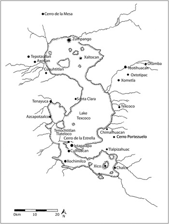
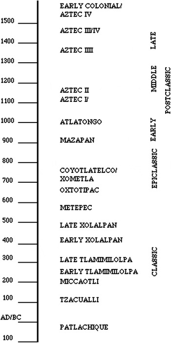
Central Mexico is a key region for the study of the development of early states and urbanism. In the 1950s, George Brainerd initiated investigations at the site of Cerro Portezuelo in the eastern Basin of Mexico to assess the continuities and discontinuities that followed the demise of the great Early Classic (a.d. 100–550/650) city of Teotihuacan (Figure 1). The artifacts and records from Brainerd's project at Cerro Portezuelo are one of the largest excavated collections from the eastern Basin of Mexico spanning the Late-Terminal Preclassic (ca. 200 b.c.–a.d. 100) to Postclassic periods (a.d. 550/650–1521) (see Figure 2). Cerro Portezuelo extends from the northern flanks of a hill and onto the edge of a deep soil alluvial plain near a pass to the southeast Basin of Mexico. Underlying Brainerd's project was a larger question: Why had the Basin of Mexico been home to a series of unusually large and influential pre-Hispanic cities and states (Nicholson Reference Nicholson1962; Nicholson and Hicks Reference Nicholson and Hicks1973)? Six decades of research have produced new understandings of the Classic and Postclassic periods and new theoretical perspectives on state formation, collapse, and regeneration. But some old questions persist.
The Basin of Mexico.

Basin of Mexico chronology.

Teotihuacan emerged about 2,000 years ago as the dominant city and state in central Mexico, and for centuries its size and influence were unparalleled in Mesoamerica. In spite of much productive research at Teotihuacan itself and regional surveys of the basin and adjoining areas, until recently archaeologists had carried out few excavations at sites in Teotihuacan's immediate hinterlands. Because of Cerro Portezuelo's long occupation that began in the Late/Terminal Formative period (ca. 600 b.c.–a.d. 100) and continued beyond the Spanish Conquest, it is a strategic site to investigate the dynamics of state formation, involving episodes of centralization and fragmentation over this long span (Cowgill Reference Cowgill, Nichols and Pool2012; Marcus Reference Marcus, Feinman and Marcus1998). Looking at these dynamics from the hinterlands, we see how Cerro Portezuelo, situated in often-contested territory, shifted its interactions as regional power centers changed over its long history. The jockeying for power that ensued after the Teotihuacan state fragmented provided an opportunity for Cerro Portezuelo to expand and become the center of one of the largest Epiclassic city-state clusters in the Basin of Mexico. Then, during another, later episode of political fragmentation following Tula's breakup, Cerro Portezuelo appears to have lost its status as a political center.
The current project of analysis of artifacts and excavation and survey data from Cerro Portezuelo seeks to advance understanding of the Teotihuacan state by examining the nature of relations between the Early Classic city and its immediate hinterlands and the change from the Teotihuacan state system to Postclassic city-state organization. Here we review the history of research concerning Cerro Portezuelo and discuss the current research project reported in the articles that comprise this Special Section. Our research complements recent investigations at other Classic hinterland sites (for example, Carballo and Pluckhahn Reference Carballo and Pluckhahn2007; Charlton et al. Reference Charlton, García Chávez, Charlton, Cabrera, Olvera, Rodríguez, Gallut and Peralta2005; García Chávez Reference García Chávez1991, Reference García Chávez and Gallut2002), contributes to a renewed interest in the Epiclassic and Early Postclassic periods along with studies of Aztec city-state development, and adds a hinterland perspective to general understandings of early state formation, collapse, and regeneration.
CERRO PORTEZUELO EXCAVATIONS AND COLLECTIONS IN THE 1950s
During a 1953 survey of Classic and Postclassic sites in the northern basin, Tolstoy made collections at a “very large site” with both Classic and Postclassic pottery on the lower slopes of Cerro Portezuelo and the adjacent valley floor 5 km east of Chimalhuacan (Tolstoy Reference Tolstoy1958:73). Based on Tolstoy's recommendations, Brainerd, of the University of California, Los Angeles (UCLA), selected Cerro Portezuelo for a major excavation project. He was interested in the Classic to Postclassic transition and the degree of cultural continuity or discontinuity between Teotihuacan and Tula (Hicks and Nicholson Reference Hicks and Nicholson1964:492).
Brainerd (Reference Brainerd1951) accomplished important work on chronology and ceramic seriation in Yucatan, and he felt that the ceramic chronology for the Basin of Mexico needed rethinking. With support from the Wenner Gren Foundation, Brainerd started fieldwork at Cerro Portezuelo in 1954. He defined a site area of 1.8 km2 along the lower slopes of Portezuelo (or Xolhuango) hill and the valley floor. Two mound groups on either side of a deep, recent barranca marked the site center. Hicks (Reference Hicks2013) describes small mounds and masonry visible on the surface of the upper part of the site, but erosion and plowing had obliterated surface architecture below the hill. The Epiclassic artifact scatter was fairly continuous to the east, but Brainerd designated this as a separate site—San Antonio.
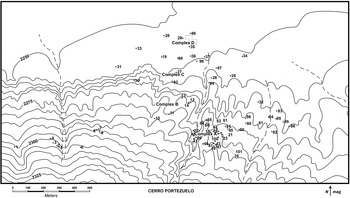
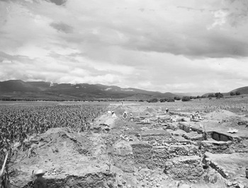
The first field season focused on chronology. To recover a large sample of pottery from different periods, Brainerd's crews dug test units or “trenches” (usually 2 × 3 m) in different areas of the site and conducted more extensive excavations in two places where they encountered complex architecture (Figure 3). Frederic Hicks joined the project for its second field season in 1955 when they focused on excavations of architecture (Figure 4). To obtain larger artifact samples, in 1955 the stratigraphic trenches were enlarged to 5 × 5 m. If excavators found complex architecture, they subdivided the 5 × 5 m grid into quarters (i.e., 2.5 × 2.5 m). In all, Brainerd's project excavated 67 test trenches, besides the larger-scale excavations (Hicks Reference Hicks2013). They designated the expanded excavations as “complexes:” Complexes A and B consisted mostly of Epiclassic remains; Complex C (Trench 93) unexpectedly uncovered a Classic period platform mound in an area that lacked surface indications of architecture; and, Complex D (Trenches 35 and 96) revealed Postclassic house remains. Hicks (Reference Hicks2013) describes the excavated architecture in detail. Artifact analyses draw primarily on the collections from the architectural excavations.
Cerro Portezuelo, showing the location of Brainerd's excavations.

Cerro Portezuelo Trench 93, looking east.

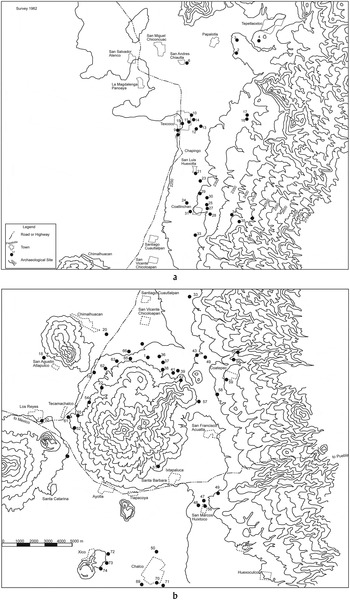
Brainerd died in 1956, and a planned third season at Cerro Portezuelo was never undertaken. Henry B. Nicholson joined the UCLA faculty in 1957 and took over the project. Nicholson, Clement W. Meighan, and David Pendergast conducted limited excavations at the site in 1958. Hicks began working with Nicholson in 1961 to complete analyses of artifacts and excavation data. In 1962, with support from the National Science Foundation, Nicholson and Hicks continued work with the excavation data and artifacts from Brainerd's project. In addition, they surveyed 74 sites in the eastern and southern Basin of Mexico between Tepetlaoxtoc to the north and Xico to the south to gather information on the geographic extent of the ceramic complexes defined for Cerro Portezuelo (Figure 5). They made random and nonrandom surface collections at most sites.
Hicks and Nicholson's site survey in the eastern and southern Basin of Mexico, which includes: (a) the Texcoco region, and, (b) the Chalco region.

Hicks and Nicholson (Reference Hicks and Nicholson1964) published a preliminary outline of the site's occupational history. At the 1973 Annual Meeting of the Society for American Archaeology, they presented a paper on the Classic period occupation (Nicholson and Hicks Reference Nicholson and Hicks1973). The objective of Nicholson and Hicks' work was to complete a final report on the archaeological investigations at Cerro Portezuelo. As their individual research agendas moved in other directions, they never compiled the final report but, once retired, Hicks resumed work on it. His first-hand knowledge of the project and artifact studies, especially of ceramics, provided an important springboard for the current studies.
CERRO PORTEZUELO ARCHIVES AND COLLECTIONS
Artifacts, along with excavation records, photographs, maps, artifact analysis records, reports, and notes from the UCLA investigations at Cerro Portezuelo have been stored at the Fowler Museum. The field notes on the excavations vary in detail, but it has been possible to determine stratigraphic sequences within the excavations and the contexts of many artifacts. Not surprisingly, we have encountered problems working with data and collections made over half a century ago.
During the 1954 and 1955 field seasons (and Nicholson and Hicks' later survey) all “non-diagnostic,” “formless,” or plain body sherds were counted and then discarded after the number was recorded. Other artifacts were kept for further analysis, except for most of the burials and some objects that the Instituto Nacional de Antropología e Historia retained in Mexico. Provenience information was marked on pottery sherds with a rubber stamp and sometimes in pencil. All other artifacts were labeled with India ink. The India ink and pencil marks have preserved, but even by the 1960s, when Hicks completed tabulating the pottery, the stamping was no longer legible on about one-fourth of the sherds, and the problem has worsened with time. Nonetheless, we were able to identify substantial samples of pottery from all periods for which context could be determined. The collection also includes 130 ceramic vessels from burial contexts and caches that are especially useful in making comparisons with Teotihuacan, Tula, and other sites (Branstetter-Hardesty Reference Branstetter-Hardesty1978; Clayton Reference Clayton2013; Crider Reference Crider2013; Hicks and Nicholson Reference Hicks and Nicholson1964).
Following the end of fieldwork at the site, UCLA archaeologists and students continued studies of the artifacts. Although most of these studies were never published, the reports are part of the site archives at UCLA (for example, Anenberg Reference Anenberg1995; Branstetter-Hardesty Reference Branstetter-Hardesty1978; Erdman Reference Erdman1994; McBride Reference McBride1954–1966; Sidrys Reference Sidrys1977). After Hicks and Nicholson completed their analyses, the excavated artifacts were kept in large trays sorted by material and type. In the late 1990s, UCLA moved the archaeology collections to a new storage facility on the campus. An inventory was made of the Cerro Portezuelo collection before the artifacts were bagged, labeled by storage tray, and boxed. In 2000–2002, with support from a National Endowment for the Humanities Preservation and Access grant, Wendy Teeter, the archaeology curator of the Fowler Museum, and her staff organized and inventoried the site records, developed a finding aid to the Cerro Portezuelo archives (http://www.oac.cdlib.org/findaid/ark:/13030/kt50001959), and began curatorial work with the maps, drawings, and photographs.
A major goal of Brainerd's original project was to develop a chronological pottery typology for the site. He felt that such a typology should be, initially, a development independent of the excavation data. Thus provenience information was stamped on the excavated sherds, and then all sherds from the site were pooled. Brainerd then sorted the pottery into groups based on “recognizable features,” including color, paste, decoration, surface treatment, form, etc., and then grouped his “sorting categories” by time period. Building on Brainerd's work, Hicks and Nicholson (Reference Hicks and Nicholson1964) defined a series of types and variants whose complete descriptions and tabulation records are included in the project archives.
Archaeologists have had difficulty understanding the relationship of Cerro Portezuelo to other settlements because it was unclear how the Cerro Portezuelo pottery categories compared with more recent classifications. The ceramic types defined by Hicks and Nicholson had not been fully published, so it was important for us to find out how they compared with subsequent studies (Bey Reference Bey1986; Cobean Reference Cobean1990; Cobean and Mastache Reference Cobean, Mastache and Healan1989; Gamboa Cabezas Reference Gamboa Cabezas1998; García Chávez Reference García Chávez2004, Hodge and Minc Reference Hodge and Minc1990, Reference Hodge and Minc1991; López Pérez Reference López Pérez2003; Mastache et al. Reference Mastache, Cobean and Healan2002; Nicolás Careta Reference Nicolá Careta2003; Parsons Reference Parsons1971; Parsons et al. Reference Parsons, Brumfiel and Hodge1996; Rattray Reference Rattray2001; Sanders Reference Sanders and Sanders1986, Reference Sanders1994–96; Sanders and Evans Reference Sanders and Evans2001; Sanders et al. Reference Sanders, Parsons and Santley1979; Sugiura Reference Sugiura1990, Reference Sugiura and Manzanilla2005a, Reference Sugiura2005b, Reference Sugiura and Valverde2006; Whalen and Parsons Reference Whalen, Parsons, Parsons, Brumfiel, Parsons and Wilson1982). As we were beginning our project, Hicks (Reference Hicks2005) also prepared an extremely useful draft report describing the pottery categories.
Branstetter-Hardesty's (Reference Branstetter-Hardesty1978:213–214) application of instrumental neutron activation analysis (INAA) and X-ray fluorescence to clay sources and pottery from Cerro Portezuelo in the 1970s represented a path-breaking study. Her work determined that it is possible to chemically distinguish ceramic provenances in the Basin of Mexico and laid the basis for expanded provenance studies. She suggested that pottery was manufactured at Cerro Portezuelo throughout its occupation.
Building on Branstetter-Hardesty's work, Nichols (Nichols et al. Reference Nichols, Brumfiel, Neff, Hodge, Charlton and Glascock2002) chose Cerro Portezuelo for a pilot study to see how useful INAA of ceramics would be for a longitudinal comparison. She selected a sample of Epiclassic and Postclassic decorated serving wares and 19 raw clays originally collected by Branstetter-Hardesty for INAA at the Missouri University Research Reactor (MURR) (Nichols et al. Reference Nichols, Brumfiel, Neff, Hodge, Charlton and Glascock2002). Charlton, Neff, and Otis Charlton sampled additional clays from several deposits in the vicinity of Cerro Portezuelo (Neff and Glascock Reference Neff and Glascock1998; Nichols and Charlton Reference Nichols and Charlton2002) and Garraty (Reference Garraty2006, Reference Garraty2013) analyzed a sample of Aztec plainwares from Cerro Portezuelo for his dissertation on Aztec markets. Although no evidence of ceramic manufacturing was noted in Brainerd's excavations or in the collections, the INAA results not only confirmed Branstetter-Hardesty's conclusion that Classic and Postclassic ceramics were made of local clays, but also that the assemblage included significant imports from other areas of the Basin of Mexico and beyond.
THE CURRENT PROJECT
Nichols and Cowgill initiated the current project to use data from Cerro Portezuelo to address issues about the organization of the Teotihuacan state in its inner hinterland, its collapse, and the development of Postclassic city-state organization. We needed to analyze the field data and artifacts so they could be integrated with results of other projects in central Mexico. It was also important to determine when Cerro Portezuelo was first occupied and how similar or different its material culture and cultural practices were to Teotihuacan, Tula, Cholula, and later Aztec imperial centers. How did patterns of interaction change as Cerro Portezuelo grew into an Epiclassic center? Were Postclassic city-states only a breakdown product of the collapse of the regional state system, or did hinterland settlements contribute to the breakup of Teotihuacan? What was the nature of Cerro Portezuelo's relationship with the Early Postclassic centers of Tula and Cholula and then later with Aztec city-states and the imperial centers of Texcoco and Tenochtitlan? What do we learn by looking at changing interactions with Cerro Portezuelo, which sat near the border of the eastern and southern Basin of Mexico?
To address these questions, the current project has undertaken analyses of all the various types of artifacts and excavation and survey data in the Cerro Portezuelo collections. An immediate task concerned curation, archiving of site records, and organizing and inventorying the boxes of artifacts. As noted above, Wendy Teeter and her staff at UCLA organized and inventoried the records and artifact collections and had begun the task of repacking the collections in standard size archival boxes, which our project completed. UCLA temporarily loaned the collection for study to Arizona State University (ASU). We electronically scanned all site records (photographs, drawings, fieldnotes, reports, correspondence, etc.) and expanded the records inventory to include the large collection of drawings and photographs. Kristin Sullivan revised maps and drawings for accuracy and to make suitable versions for publication.
We have been able to make productive use of the Cerro Portezuelo collections because the excavation, survey, and analysis records have been kept with the artifacts. Nonetheless, we encountered some problems. The project archives lack some of Brainerd's notes—a fact we are aware of only through Hicks' first-hand knowledge of the project. Although we reconstructed the history of analyses of obsidian artifacts, including Nicholson's loan of them to Joseph Michels at Penn State for an early obsidian hydration study, we were unsuccessful in locating all of them. Nonetheless, Parry and Glascock (Reference Parry and Glasock2013) have gleaned valuable information from the remaining chipped stone tools. Excavated deposits were not screened, so little debitage was collected. Obtaining larger and more representative chipped stone collections from the site is a priority.
The excavations at Cerro Portezuelo predated the development of flotation and pollen recovery from archaeological contexts. At least one maize cob was found, and Biskowski and Watson's (Reference Biskowski and Watson2013) analysis of ground stone artifacts revealed the presence of agricultural implements, maguey scrapers, and hoes. Stone balls used as sling missiles in hunting or warfare also are present.
Animal bone also was not routinely collected in the 1950s, but Wendy Teeter's (Reference Teeter2013) examination of the remains in the collections sheds additional light on subsistence practices. The remains include tortoises valued for the shell as well as meat, wild turkey, ducks, rabbits and hares, deer, and giant pocket gophers that probably also were eaten. Badgers might have been valued for their fur and because they hunt rodents in cultivated fields. Dogs lived at the site along with people and some were incorporated in ritual interments.
Spindle whorls came into use in the Postclassic period at Cerro Portezuelo and elsewhere in central Mexico. Bone awls and needles provide further evidence of weaving and sewing as household activities. Household refuse also included bone pressure flakers and a possible maize husker, along with some bone debitage.
The study of mortuary practices and human skeletal remains has made important advances since the 1950s. For this project we were especially interested in the information they provide on cultural practices and affiliations, along with determining their geographic origins. Most of the burials excavated by Brainerd's project were left in Mexico, and we have not yet tracked them down. Of those in the available collection, most individuals spent their lives in the Cerro Portezuelo area. However, Cerro Portezuelo's rapid growth in the Epiclassic involved some movement of people from inside and outside the Basin of Mexico into the town (Spence et al. Reference Spence, White and Longstaffe2013).
Ceramics
Ceramics comprise the bulk of the Cerro Portezuelo collections, and they have been a major focus of our research. Although provenience data have been lost on more than a quarter of the sherds, because the rubber stamp ink used to mark them was not indelible, Sarah Clayton and Destiny Crider became very adept at reading faint traces of the stamped provenience codes. Fortunately, in the 1960s Hicks developed a modified type-variety scheme in his analysis of the pottery and prepared detailed tabulation forms that are part of the project archives. He recorded types and variants by provenience, and also tabulated how many in each category lacked provenience data as of the early 1960s.
In approaching the ceramic analyses, we began with a ceramic workshop in Mexico at the ASU-managed Teotihuacan Research Center to become familiar with current ceramic classifications. Thanks to the workshop's location, we were able to take advantage of collections from Teotihuacan, along with other Epiclassic and Postclassic sites, and to benefit from discussions with Mexican archaeologists and lab analysts.
We started our examination of the Cerro Portezuelo pottery with the vessels from burials and caches. Clayton (Reference Clayton2013) focused on Formative and Classic ceramics and their relationship to Teotihuacan pottery, while Crider (Reference Crider2013) studied the Epiclassic and Early Postclassic ceramics. Clayton was able to analyze all of the Preclassic and Classic pottery, but we realized that, given the size of the Epiclassic and Postclassic collections, we could not reanalyze every sherd. Crider examined substantial samples of pottery from all the types and variants defined by Hicks. As a result, we are now able to relate Hicks' pottery categories to other ceramic chronologies and also, in some cases, develop finer distinctions. Garraty expanded his studies to include Aztec decorated wares. Montoya's (Reference Montoya2008) study of figurines explored how they changed over the long time of occupation represented at Cerro Portezuelo.
Source Analyses
We employed composition analysis of ceramics and lithic artifacts from the site to see how interactions within the Basin of Mexico changed with the cycles of state formation from the Terminal Formative to the Early Colonial period, representing a time span of nearly 2,000 years. Parry and Glascock (Reference Parry and Glasock2013) discuss the chipped stone results, and Biskowski and his colleagues are conducting source studies of ground stone artifacts. By far the largest source study carried out by this project is of ceramics. The ceramic compositional results were generated by INAA at MURR, under the direction of Michael D. Glascock; Hector Neff undertook the statistical analysis of the data to define composition groups. The details of INAA at MURR are described in a number of publications (see Glascock Reference Glascock and Neff1992; Neff Reference Neff, Ciliberto and Spoto2000) and will not be repeated here. A total of 1,299 fragments of pottery and figurines, along with raw clay samples from Cerro Portezuelo, have now been analyzed. (In addition, 197 mostly Late Preclassic and Epiclassic sherds from Nicholson and Hicks' site survey of the eastern and southern Basin also were analyzed). The large database of ceramics and raw materials from the Basin of Mexico provides a basis for inferring provenance of the Cerro Portezuelo materials (Crider et al. Reference Crider, Nichols, Neff and Glascock2007; Hodge et al. Reference Hodge, Neff, Blackman, Minc and Neff1992, Reference Hodge, Neff, Blackman and Minc1993; Neff and Glascock Reference Neff and Glascock2000; Neff et al. Reference Neff, Glascock, Charlton, Charlton and Nichols2000; Neff and Hodge Reference Neff, Hodge and Hodge2008; Nichols et al. Reference Nichols, Brumfiel, Neff, Hodge, Charlton and Glascock2002; Ruvalcaba-Sil et al. Reference Ruvalcaba-Sil, Salamanca, Manzanilla, Miranda, Cañetas Ortega and López1999).
The present study builds on the earlier ceramic provenance research in the Basin of Mexico. As a first step, the Cerro Portezuelo analyses were compared to groups that had been established previously and linked to raw material resources sampled from throughout the basin (see Nichols et al. Reference Nichols, Brumfiel, Neff, Hodge, Charlton and Glascock2002).
The most basic pattern in the Basin of Mexico ceramic compositional data, borne out in multiple studies since 1992, divides the basin along north-south and east-west axes. In the south, ceramics made in the Chalco Basin can be reliably discriminated from ceramics produced in the Tenayuca-Tenochtitlan region, while in the north, ceramics made in the vicinity of Otumba (Teotihuacan Valley) can be discriminated from ceramics made to the west, in the Cuauhtitlan-Tultitlan region. A fifth group subsumes ceramics made in the vicinity of Texcoco, on the eastern shore of Lake Texcoco. As stressed elsewhere (for example, Nichols et al. Reference Nichols, Brumfiel, Neff, Hodge, Charlton and Glascock2002), the geomorphology of the Basin of Mexico complicates assignments of some specimens to subgroups, since compositions change gradually along the north-south and east-west axes. The Texcoco group, especially, includes a number of specimens that could be plausibly placed in the Chalco, Otumba, or Tenochtitlan groups.
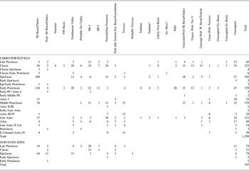
The Cerro Portezuelo analyses were compared to the five previously established groups using Mahalanobis distances from the group centroids calculated three different ways (Table 1). In the “raw” comparison, Mahalanobis distances of individual specimens from the five group centroids were calculated using base-10 logs of all measured elements except nickel, which shows relatively poor sensitivity and precision, and terbium, which has proven unreliable in basin studies carried out previously. The “best relative fit” (BRF) comparison involved adjusting all elements by the specimen's average ratio to the group mean—all group members having been similarly adjusted—and then calculating the Mahalanobis distances. As argued by Beier and Mommsen (Reference Beier and Mommsen1994), this practice compensates for dilution, such as higher silica (quartz) content in some samples, or weighing errors, which may inflate or deflate concentrations systematically. The third comparison was based on the four discriminant axes derived from a canonical discriminant analysis of the five established reference groups.
Counts of ceramics by period by composition group

The “chemical group assignments” were determined by considering all three Mahalanobis-distance calculations, plus the “best group” assignments (following publication of this article, the complete INAA dataset will be available at http://archaeometry.missouri.edu/datasets/datasets.html). Specimens showing much higher probabilities for one group than all others (for example, AZC064) were assigned to that group (Chalco in the case of AZC064). Some cases presented difficulties; AZC086, for instance, appears to be assignable to Texcoco based on the discriminant-axis comparison, but it was instead assigned to Chalco because the raw and BRF comparisons both clearly favor Chalco. Assignments to Texcoco were most problematic because of its intermediate position relative to the Teotihuacan Valley, western basin (Tenochtitlan), and southern basin (Chalco). However, since the vast majority of apparent misassignments for Texcoco group members are to the Chalco group, specimens assigned to Texcoco can be confidently assigned a provenance in the east and southeast basin (i.e., probably not too far from Cerro Portezuelo). Specimens that showed either conflicting evidence of provenance or very low probabilities of membership in all groups were left unassigned. In cases where the weight of evidence clearly favors one group over others, a “probable” assignment is indicated.
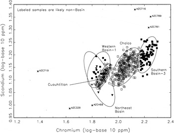
The Cerro Portezuelo assemblage contains ceramics originating in all of the major production zones of the Basin of Mexico identified in previous work (Figures 6–10). Consistent with earlier studies, north-south geographic trends in composition create the major axes of variation (principal components) in the Cerro Portezuelo data. Transition metals (including chromium and iron), show perhaps the clearest geographic gradients, with low values in the northern basin and progressively higher values toward the south. The most extreme “southerly” compositions (the highest transition metals) are in two newly defined groups, SB-3 and SB-4. WB-1, another group not recognized in previous studies, appears—based on low-transition metals—to derive from the northern basin.
Chromium and scandium log concentrations in several Basin of Mexico reference groups that were defined or enlarged in this study. Chromium shows a clear trend from low values in the north and west to higher values in the south and east (see Nichols et al. Reference Nichols, Brumfiel, Neff, Hodge, Charlton and Glascock2002). On this basis, Southern Basin-3 is inferred to represent production in the far southeastern basin, while Western Basin-1 and Northeast Basin are inferred to represent production in the northern and/or western basin. The Chalco and Cuauhtitlan groups plotted here consist of specimens defined in earlier studies. Ellipses represent a 90% confidence level for membership in the reference groups.

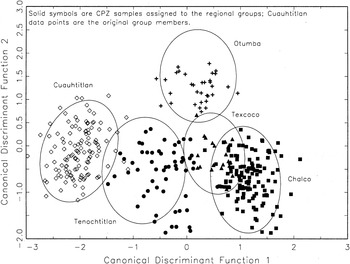
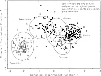
Scores on Canonical Discriminant Functions 1 and 2 for CPZ samples assigned to the various basin reference groups. Ellipses represent a 90% confidence level for membership in the previously defined basin reference groups. Solid symbols are new CPZ samples assigned to the reference groups, while the open diamonds are original Cuauhtitlan group members (no new CPZ samples were assigned to Cuauhtitlan).

Scores on Canonical Discriminant Functions 1 and 3 for CPZ samples assigned to the various basin reference groups. Ellipses represent a 90% confidence level for membership in the previously defined basin reference groups. Solid symbols are new CPZ samples assigned to the reference groups, while the open diamonds are original Cuauhtitlan group members (no new CPZ samples were assigned to Cuauhtitlan).

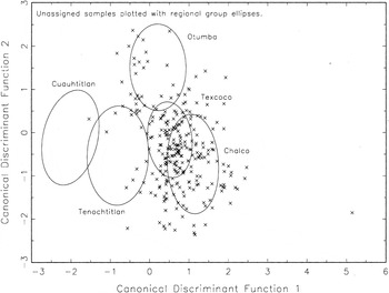
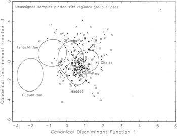
Scores on Canonical Discriminant Functions 1 and 2 for CPZ samples that were not assigned with confidence to the various basin reference groups. Ellipses represent a 90% confidence level for membership in the previously defined basin reference groups. Many of these samples, however, are assigned provisionally, as discussed in the text.

Scores on Canonical Discriminant Functions 1 and 2 for CPZ samples that were not assigned with confidence to the various basin reference groups. Ellipses represent a 90% confidence level for membership in the previously defined basin reference groups. Many of these samples, however, are assigned provisionally, as discussed in the text.

Within the northern basin, rare earth elements and hafnium appear to define an east-west gradient from low values in the Teotihuacan Valley to higher values in the Cuauhtitlan region, with WB-1 most closely affiliated with Cuauhtitlan. Based on uranium (higher values in the north) and iron (higher values in the south), the WB-1 group, while similar to Cuauhtitlan, may reflect a slightly more southerly derivation.
As discussed, the Texcoco group overlaps Tenochtitlan and especially Chalco, on most axes. Nonetheless, a canonical discriminant analysis (Figures 7–9) effects a reasonably good separation between the three groups, the main remaining overlap being between Chalco and Texcoco. A cautious interpretation of these observations is that, while the Texcoco group as a whole is probably dominated by ceramics made along the eastern shore of Lake Texcoco north of Cerro Portezuelo, provenance assignments for individual sherds should be considered tentative. Similarly, it is possible that some of the “Chalco group” sherds were, in fact, made farther north, in the Texcoco region.
Most pottery consumed at Cerro Portezuelo originated in the eastern or southeastern basin. With 440 analyses assigned to Chalco, 119 assigned to SB-3 and SB-4, and 73 assigned to Texcoco, a total of 632 are confidently attributable to this region. “Probable” assignments add 72 to the Chalco total and 30 to the Texcoco total, bringing the total “local” analyses to 734, approximately 57% of the total database.
While pottery consumption emphasized the most proximate production centers, a surprising number of pots consumed at Cerro Portezuelo originated in more distant regions of the basin. One hundred and three analyses are confidently attributed to the Tenochtitlan-Tenayuca region, and an additional 38 are probably derived from that region. Seventy-nine are confidently attributed to the Teotihuacan Valley, with an additional 47 probably originating there. The least well-represented region is Cuauhtitlan (Tultitlan), with only nine specimens attributed with confidence to the reference group, an additional 13 probably derived from somewhere in the northwest basin, and another 30 in WB-1, which probably originates somewhere in the northwest basin as well.
Finally, a small percentage of the Cerro Portezuelo assemblage probably originates outside the Basin of Mexico. Four of these are “Granular ware,” which has a very high-chromium, high-calcium, low-aluminum composition and whose origin is probably in the state of Guerrero. Other “likely non-basin” samples are plotted along with the basin reference groups; they are a mix of types that pertain primarily to Late Preclassic through Classic periods.
A key strength of the project is the large sample size—almost 1,300 individual analyses from Cerro Portezuelo (and nearly 200 analyses from other nearby sites), and all but 210 assigned to a compositional group with at least some level of confidence. With the long occupation history of Cerro Portezuelo, this data set preserves a detailed record of the consumption patterns of people living in the southeastern basin during 1,500 or more years. Combining these analyses with the other project studies provides a unique, long-term perspective on interaction patterns within the Basin of Mexico.
CERRO PORTEZUELO IN REGIONAL CONTEXT
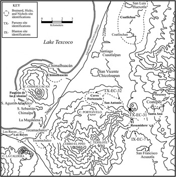
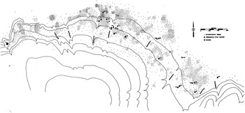
Parsons' (Reference Parsons1971:61, 75) survey of the eastern basin in 1967 covered Cerro Portezuelo (Figure 11). The high density of Epiclassic artifacts on the surface obscured the Classic period occupation, but Parsons (Reference Parsons1971:196) suggested a dispersed Early Classic occupation of about 60 ha. Cerro Portezuelo was anomalous compared to the Texcoco region as a whole, where in the Early Classic period the number, size, and density of sites decreased and most sites with Terminal Formative occupations declined (Parsons Reference Parsons1971). During the Classic period Parsons roughly estimated that there would have been around 300–900 (and perhaps as many as 1,200) people dispersed over the area of Cerro Portezuelo (designated by Parsons [1971:60–61, 66] as TX-EC-32 and TX-LC-18). As defined by Parsons, Cerro Portezuelo also includes the area to the east that Brainerd designated as the site of San Antonio (see Hicks and Nicholson Reference Hicks and Nicholson1964:498, Map 2). Further to the east, the survey found additional Classic and Epiclassic occupation over a 35 ha area with four pyramidal structures (Figure 12). Although Parsons (Reference Parsons1971:74–75), defined it as a separate settlement (TX-EC-31, TX-LC-17, and TX-ET-17), he thinks TX-EC-31 also was part of Cerro Portezuelo.
Surveys of the Cerro Portezuelo site area.

Map of Cerro Portezuelo based on Jeffrey Parsons (Reference Parsons1971) survey. Redrawn by Kristin Sullivan.

Still further east, Blanton (Reference Blanton1972:69) recorded another Classic-Postclassic settlement (Ix-EC-7, Ix-EC-8, Ix-ET-1, IX-LT-10, Ix-LT-11, and Ix-A-11) with a pyramid mound. Hicks and Nicholson (Reference Hicks and Nicholson1964:498, Map 2) called the site El Resumidero, but Blanton would include it as a further extension of Cerro Portezuelo. The surveys all point to the lower eastern slope of Cerro Portezuelo and adjoining plain as a significant focus of settlement in the Classic, Epiclassic, and Early Postclassic periods.
Sanders et al. (Reference Sanders, Parsons and Santley1979) and Mayer-Oakes (Reference Mayer-Oakes1959, Reference Mayer-Oakes1960) thought Cerro Portezuelo was a small administrative center under Teotihuacan. Parsons (Reference Parsons1971:196) was more cautious, noting that the surface concentrations of Early Classic pottery were generally light explaining that “we would tend to view TX-EC-32 as little more than a larger variant of our standard Classic villages in the Texcoco region.” By a.d. 450 (what Parsons called the Late Classic), the number and size of Classic sites in the Texcoco region declined further, except for Cerro Portezuelo, which may have grown slightly, perhaps to 80 ha. Since the time of Parsons' survey and his analysis of surface collections, archaeologists have gained a better understanding of the Teotihuacan ceramic chronology. Parsons' survey collections from Cerro Portezuelo and other Classic sites in the Texcoco region should be reanalyzed.
Late in Teotihuacan's history, probably around a.d. 550, the population declined dramatically and, by around a.d. 650, civic-ceremonial structures along the Avenue of the Dead were burned and idols were desecrated. Rattray (Reference Rattray2001:435) suggests the city was briefly abandoned. Cabrera Castro and Gómez Chávez (Reference Cabrera Castro, Gómez Chávez, Mastache, Cobean, García Cook and Hirth2008) report signs of rapid abandonment in the La Ventilla district, just outside the central core. The Teotihuacan state system fragmented. With the Basin of Mexico divided into a series of small polities during the Epiclassic period, the city-state became the dominant political form of the Postclassic period (Charlton and Nichols Reference Charlton, Nichols, Nichols and Charlton1997).
Cerro Portezuelo expanded significantly in size as the center of a nucleated settlement cluster separated from other such clusters (Sanders et al. Reference Sanders, Parsons and Santley1979:132). Parsons (Reference Parsons1971:258) estimates that the Epiclassic occupation covered 400 ha, with a population on the order of 12,000 people. His survey mapped 22 civic-ceremonial mounds, along with residential mounds and concentrations of stone rubble from buildings and artifacts (Figure 12). Some of the civic-ceremonial mounds formed plaza groups that Parsons suggests might represent barrio-like divisions. The Epiclassic public architecture Hicks (Reference Hicks2013) describes is consistent with Cerro Portezuelo's role as a city-state center.
The Early Postclassic saw another major shift in regional settlement patterns and political alignments. A higher proportion of people, especially in the southern basin, lived in hamlets and small villages than at any other time (Alden Reference Alden, Renfrew and Cooke1979; Charlton and Nichols Reference Charlton, Nichols, Nichols and Charlton1997:194–196; Sanders et al. Reference Sanders, Parsons and Santley1979:138). With a substantial Early Postclassic occupation, Cerro Portezuelo stands out as anomalous in the Texcoco region, where elsewhere population declined and was generally quite dispersed. Similarly, in the southern basin there was an equally abrupt shift from three-fourths of the population living in nucleated settlements during the Epiclassic to more than three-fourths dispersed in Early Postclassic hamlets and small villages (Parsons Reference Parsons1971:204; Parsons et al. Reference Parsons, Brumfiel, Parsons and Wilson1982:339).
Archaeologists have attributed these settlement shifts to the expansion of the “Toltec” state of Tula to the north of the Basin of Mexico and growth of Cholula to the southeast (Charlton and Nichols Reference Charlton, Nichols, Nichols and Charlton1997:194–198; Sanders et al. Reference Sanders, Parsons and Santley1979). However, Smith and Montiel (Reference Smith and Montiel2001) have challenged the status of Tula as an empire. Even those who see Tula as an expansionist state recognize that it did not politically unify all of the Basin of Mexico (Charlton and Nichols Reference Charlton, Nichols, Nichols and Charlton1997:195–196; Sanders et al. Reference Sanders, Parsons and Santley1979). The southern Basin of Mexico had close ties to Cholula.
Beginning in the Early Postclassic and continuing into the Middle Postclassic period, multiple ceramic complexes were present in the Basin of Mexico, mostly with nonoverlapping distributions (Parsons et al. Reference Parsons, Brumfiel and Hodge1996): (1) we find Aztec I, the earliest manifestation of Aztec Black-on-Orange decorated ware, and early Chalco-Cholula polychromes in the southern Chalco-Xochimilco region, at Xaltocan in the north central basin, and to the east at Cholula in Puebla; (2) Mazapan-Tollan (or Late Toltec) ceramics, however, dominate the eastern and northern basin (García Chávez Reference García Chávez2004; Nicolás Careta 2003; Sanders Reference Sanders and Sanders1986). Crider (Reference Crider2013; see also Nicolás Careta 2003) discusses the strong parallels between this ceramic complex and Early Postclassic pottery at Teotihuacan and Tollan pottery at Tula (García Chávez Reference García Chávez2004:353–354).
Sanders (Reference Sanders and Sanders1986) proposed two subdivisions of the Early Postclassic period in the Teotihuacan Valley. In his first subphase, the Valley was under the control of a small state centered at Teotihuacan. Sanders suggested that Mazapan Wavy-Line Red-on-Natural pottery painted with a multiple-brush technique was diagnostic of the first subphase and perhaps originated at Teotihuacan. López Pérez and Nicolás Careta (Reference López Pérez, Nicolás Careta and Manzanilla2005:285) also see its origins in the Teotihuacan Valley but with influences from the Bajío, as groups that included craft specialists continued moving into Teotihuacan during the Early Postclassic (Manzanilla Reference Manzanilla and Manzanilla2005). Bey (Reference Bey1986) indicates that Wavy-line Red-on-Natural, however, is more abundant in some parts of the Tula area than previously recognized.
The presence of “Toltec” orange and cream slipped wares (local imitations of Tollan phase pottery types at Tula) distinguishes Sanders' second, Atlatongo subphase that he thought marks the expansion of the Tula state in the Basin of Mexico. Since the ceramic chronology at Tula was not refined until after the conclusion of the Basin of Mexico settlement surveys, most researchers refer to the entire Early Postclassic ceramic complex in the eastern and northern basin as Mazapan-Tollan or Late Toltec. The Mazapan-Tollan complex occurs from Azcapotzalco north through the eastern basin, including Cerro Portezuelo, but does not extend much further south except at some sites in the southern basin where Mazapan and Aztec I/Chalco-Cholula co-occur (García Chávez Reference García Chávez2004:Figure 3.2; Parsons and Gorenflo Reference Parsons, Gorenflo, Martinez, Martos and Cobean2013). The spread of Tollan-style pottery indicates close ties between these areas of the Basin of Mexico and Tula. Crider (Reference Crider2011, Reference Crider2013) has been able to subdivide the phasing of Early Postclassic ceramics from Cerro Portezuelo, and this allows her to more closely explore Cerro Portezuelo's interactions with Tula and Cholula.
Previous INAA studies showed an increase in ceramic exchange between urban centers beginning in the Early Postclassic. For example, Xaltocan imported substantial amounts of Early Postclassic Aztec I/Chalco-Cholula pottery (Nichols et al. Reference Nichols, Brumfiel, Neff, Hodge, Charlton and Glascock2002). Despite growing market exchange in the Early Postclassic, strong political/ethnic barriers limited the movement of ceramics between sites with Aztec I ceramics and sites with Mazapan-Tollan pottery. The east-west division of market zones in the Basin of Mexico that Blanton (Reference Blanton, Berdan, Blanton, Boone, Hodge, Smith and Umberger1996:60) recognized for the Middle Postclassic period and Hassig (Reference Hassig1985:142–144) attributed to the Late Postclassic period is apparent in the Early Postclassic (Nichols et al. Reference Nichols, Brumfiel, Neff, Hodge, Charlton and Glascock2002). This east-west division was longstanding: it is evident in the Early Classic source data from Cerro Portezuelo and goes back to the Early Formative/Preclassic period (Grove Reference Grove2007).
Population dislocations and political fragmentation again followed the breakup of the Toltec state. By the twelfth century Aztec city-states can be detected archaeologically, and some were founded even earlier (Hodge Reference Hodge, Berdan, Blanton, Boone, Hodge, Smith and Umberger1996). Nicholson (Reference Nicholson1972:179–196) proposed that Cerro Portezuelo was the site of a Toltec center, Tlatzallan, which, according to documentary sources, continued to be occupied after the fall of Tula until it reportedly was abandoned in 1298 or 1350. However, there is enough Aztec II, III, Aztec III/IV, and Aztec IV Black-on-Orange pottery from the excavations at Cerro Portezuelo to establish that people lived at the site during the Middle and Late Postclassic and Early Colonial periods.
In the Middle Postclassic period, Cerro Portezuelo was no longer a city-state capital, as Chimalhuacan incorporated the settlement into its domain (Hodge Reference Hodge, Nichols and Charlton1997:216–217; Nicholson Reference Nicholson1972:159). Amid this volatile political situation, economic interactions intensified through market networks and tribute taking. The city-states of the Middle Postclassic were once thought to be associated with solar markets, but composition and stylistic studies of Early Aztec pottery indicate that goods moved through non-centralized market networks during the Middle Postclassic. Some of us see indications of the beginnings of Aztec market hierarchies at this time as exports from politically powerful centers expanded (Blanton Reference Blanton, Berdan, Blanton, Boone, Hodge, Smith and Umberger1996; Garraty Reference Garraty2006; Minc Reference Minc2006, Reference Minc2009; Nichols et al. Reference Nichols, Brumfiel, Neff, Hodge, Charlton and Glascock2002, Reference Nichols, Elson, Cecil, de Estrada, Glascock and Mikkelson2009).
The Late Postclassic incorporates the founding and growth of the Aztec empire. Around 1430 Netzahualcoyotl of Texcoco appointed the ruler of the Chimalhuacan altepetl, indicating that the lakeshore town and its hinterlands that included Cerro Portezuelo were part of the Acolhua confederation and the Aztec empire (Hodge and Blanton Reference Hodge, Blanton, Berdan, Blanton, Boone, Hodge, Smith and Umberger1996:230). Chimalhuacan maintained close ties to the rulers of Texcoco until the Spanish Conquest. The southeastern sector of the Texcoco region around Cerro Portezuelo became a sparsely occupied frontier between the Acolhua and Chalca confederations (Parsons Reference Parsons1971:229).
In addition to political consolidation, the Late Postclassic period also saw increasing interactions among elites across former city-state boundaries. This was one stimulus to expanding trade (Nichols et al. Reference Nichols, Elson, Cecil, de Estrada, Glascock and Mikkelson2009). Large amounts of goods moved through the market system as demonstrated by the ubiquity of obsidian tools and source studies of Aztec ceramics (Brumfiel and Hodge Reference Brumfiel, Hodge, Mastache, Parsons, Santley and Puche1996; Charlton et al. Reference Charlton, Charlton, Nichols, Neff, Pool and Bey2007; García Chávez Reference García Chávez2004; Garraty Reference Garraty2006; Hodge and Neff Reference Hodge, Neff and Brumfiel2005; Hodge et al. Reference Hodge, Neff, Blackman, Minc and Neff1992, Reference Hodge, Neff, Blackman and Minc1993; Ma Reference Ma2003; Minc Reference Minc1994, Reference Minc2006, Reference Minc2009; Minc et al. Reference Minc, Hodge, Blackman, Hodge and Smith1994; Neff et al. Reference Neff, Glascock, Charlton, Charlton and Nichols2000, Neff and Hodge Reference Neff, Hodge and Hodge2008; Nichols and Charlton Reference Nichols and Charlton2002; Nichols et al. Reference Nichols, Brumfiel, Neff, Hodge, Charlton and Glascock2002, Reference Nichols, Elson, Cecil, de Estrada, Glascock and Mikkelson2009). Debate persists over the degree to which political boundaries and regionalism toward the peripheries of the Basin of Mexico impeded the development of a fully integrated market system (Charlton Reference Charlton, Hodge and Smith1994; Charlton et al. Reference Charlton, Nichols and Charlton2000; Garraty Reference Garraty2006; Hodge Reference Hodge1992; Hodge et al. Reference Hodge, Neff, Blackman, Minc and Neff1992, Reference Hodge, Neff, Blackman and Minc1993; Minc Reference Minc2006, Reference Minc2009; Nichols et al. Reference Nichols, Brumfiel, Neff, Hodge, Charlton and Glascock2002, Reference Nichols, Elson, Cecil, de Estrada, Glascock and Mikkelson2009). The expansion of the market system and intensification of market exchange were key developments of the Postclassic. At the same time, the growth of Tenochtitlan and, to a lesser extent, Texcoco as imperial capitals and centers of craft production enlarged the market area for their products, including Aztec III Black-on-Orange pottery.
Nahua speakers continued to make earthenware pottery and obsidian tools after the Spanish Conquest while also adopting new technologies. Figurine production diminished under the gaze of the Catholic church, and the scale of exports from the Tenochtitlan region declined (Charlton et al. Reference Charlton, Charlton, Nichols, Neff, Pool and Bey2007; Garraty Reference Garraty2006, Reference Garraty2013; Nichols et al. Reference Nichols, Brumfiel, Neff, Hodge, Charlton and Glascock2002, Reference Nichols, Elson, Cecil, de Estrada, Glascock and Mikkelson2009).
DISCUSSION
Terminal Formative/Preclassic and Early ClassicFootnote 1
Most archaeologists see the highly primate settlement system that developed in concert with Teotihuacan's political integration of the Basin of Mexico as evidence of powerful rulers who created a highly centralized regional system, politically, economically, and ideologically (Blanton et al. Reference Blanton, Kowalewski, Feinman and Finsten1993:123; Charlton and Nichols Reference Charlton, Nichols, Nichols and Charlton1997:184, 188; Cowgill Reference Cowgill, Adams and MacLeod2000:263, 285, Reference Cowgill, Evans and Webster2001a:79, Reference Cowgill, Peregrine and Ember2001b:14, Reference Cowgill and Smith2003:38, Reference Cowgill and Stone2007; Millon Reference Millon and Berlo1992:222–223; Sanders et al. Reference Sanders, Parsons and Santley1979:108). Consequently, many archaeologists have interpreted the rapid resettlement of the Basin of Mexico that began perhaps as early as a.d. 200 as a state-directed recolonization program that included the founding of Cerro Portezuelo. The political advantages of having 50–60% of the basin's population, including large numbers of farmers, continuing to reside in the city apparently outweighed the economic inefficiencies of this primate system (Millon Reference Millon, Yoffee and Cowgill1988:103; Sanders et al. Reference Sanders, Parsons and Santley1979:128).
Such interpretations, however, have been based on very limited knowledge of the Teotihuacan state administrative structure. It has variously been called an empire, a city-state, a hegemonic city-state, and a regional state (Blanton et al. Reference Blanton, Kowalewski, Feinman and Finsten1993:135; Charlton and Nichols Reference Charlton, Nichols, Nichols and Charlton1997:184; Cowgill Reference Cowgill, Peregrine and Ember2001b:13, Reference Cowgill and Stone2007; Hassig Reference Hassig1992; Smith and Montiel Reference Smith and Montiel2001; Trigger Reference Trigger2003:97; Yoffee Reference Yoffee, Nichols and Charlton1997). Sanders et al. (Reference Sanders, Parsons and Santley1979:115) suggest that Teotihuacan's recolonization strategy was designed to break down former loyalties by avoiding previous centers and to maximize resource exploitation. Administration is thought to have come directly from Teotihuacan, in the case of areas close to the city, or through secondary centers in the case of more distant parts of the basin (Millon Reference Millon and Sabloff1981:222). Within this scheme, Cerro Portezuelo has been interpreted as a small administrative center.
The findings from our project—discussed in the following articles in this issue—raise questions about this model, especially as it applies to the southeast Basin of Mexico. Cerro Portezuelo's initial occupation was associated with Patlachique ceramics of the Early Terminal Formative/Preclassic period, not the Early Classic as previously thought (Clayton Reference Clayton2013; Hicks and Nicholson Reference Hicks and Nicholson1964:497; Montoya Reference Montoya2008; Parsons Reference Parsons1971:61–62). There may be more Formative occupation buried by deep soil below the base of the hill at Cerro Portezuelo. Some Tzacualli pottery also is present, indicating occupation in the Late Terminal Formative/Preclassic period. The preceding Late Formative was a period of settlement growth and expansion in the Basin of Mexico and the Texcoco region saw the development of small regional centers, each associated with a hinterland, while Cuicuilco in the southwestern basin became the first city. By 100 b.c. Teotihuacan had become the dominant center in the northeastern basin, competing with Cuicuilco.
We only know of the Patlachique/Tezoyuca Terminal Formative/Preclassic occupation at Cerro Portezuelo from the presence of pottery and figurines, but there is little to suggest that Teotihuacan founded the site. In fact, Cerro Portezuelo's economic affiliations and interactions at that time were primarily with the southern Texcoco region and southeast basin, the source of most of its pottery. Some imports came from the Teotihuacan Valley and the Tenochtitlan composition group, along with minor amounts perhaps from more distant areas. Clayton (Reference Clayton2013) thinks the Classic occupation at Cerro Portezuelo represents a continuation of its pre-Teotihuacan settlement, but Cerro Portezuelo shifted the focus of its interactions west to the Tenochtitlan/Azcapotzalco area and north to Teotihuacan. Although not larger than other Classic villages in the Texcoco region, construction during Early Tlamimilolpa (a.d. 200–275) of a complex of plastered platforms, 2 m high, with traces of mural paintings on their exteriors, along with offerings and burials, indicates the presence of elites with local administrative authority (Hicks Reference Hicks2013). Trade with Teotihuacan, and emulation of Teotihuacan style objects, architecture, and selected ritual practices, along with connections to the larger regional centers of Azcapotzalco and Cerro de la Estrella, probably enhanced the standing of Cerro Portezuelo's leaders and elites. Most other Classic sites in the southeast basin were small, perhaps seasonally occupied by farmers who lived at Teotihuacan (Sanders and Santley Reference Sanders, Santley, Vogt and Leventhal1983:262).
By a.d. 100 Teotihuacan was a primate center par excellence. This led archaeologists to see exchange relations between Teotihuacan and its inner hinterland organized as a solar market system, “with the flow of goods and materials restricted and hierarchical, moving into and out of the city through its settlement hierarchy….Administrative intervention in the exchange process may have been an important source of state revenues” (Millon Reference Millon, Yoffee and Cowgill1988:219–220; see also Sanders et al. Reference Sanders, Parsons and Santley1979:114). Santley (Reference Santley and Miller1983; Santley et al. Reference Santley, Kerley, Kneebone and Isaac1986; but compare Clark Reference Clark and Isaac1986) favored a dendritic central place system. Blanton et al. (Reference Blanton, Kowalewski, Feinman and Finsten1993:129) see the small size of regional centers, limited evidence of craft production outside Teotihuacan, and low hinterland population densities as evidence of underdevelopment caused by Teotihuacan's primate system. Millon (Reference Millon, Yoffee and Cowgill1988: 221) thinks that once this system was established it was maintained until Teotihuacan's collapse, around a.d. 650. Manzanilla (Reference Manzanilla and Berlo1992, Reference Manzanilla and Manzanilla1997) doubts that marketplace exchange and tribute systems were present in Classic period Teotihuacan. She proposes a “temple-centered” redistributive model wherein craft specialists and long-distance exchange were controlled by the Teotihuacan priesthood. In her view, it was the collapse of Teotihuacan that triggered greater separation of the political and economic realms, dominance of tributary states, and the development of marketplace exchange. Others, including the authors of this study, doubt that temple-centered redistribution could have been the only mode of exchange for city the size of Teotihuacan (Blanton et al. Reference Blanton, Kowalewski, Feinman and Finsten1993:212–213; Charlton Reference Charlton1978, Reference Charlton, de Tapia and Rattray1987; Cowgill Reference Cowgill, Peregrine and Ember2001b:15; Kurtz Reference Kurtz1987; Millon Reference Millon and Berlo1992:282; Sanders and Santley Reference Sanders, Santley, Vogt and Leventhal1983; Spence Reference Spence1981, Reference Spence and Folan1985, Reference Spence and Isaac1986, Reference Spence, de Tapia and Rattray1987; Trigger Reference Trigger2003:374, 403).
How centralized was the regional economy under Teotihuacan? We have learned from source analyses that Cerro Portezuelo imported as much pottery from the Tenochtitlan composition group as it did from the Teotihuacan Valley and also used locally made variants of many, but not all, types of Teotihuacan domestic wares (Clayton Reference Clayton2013). Azcapotzalco, the second largest Classic center in the Basin of Mexico, is a likely source of ceramics assigned to the Tenochtitlan composition group. It was a center of Aztec ceramic production, and ceramic manufacturing began at Azcapotzalco by the Early Classic period (Ma Reference Ma2003). Although archaeologists have debated the scale of Teotihuacan's obsidian industry, they have generally assumed that Teotihuacan dominated Early Classic prismatic blade production in the Basin of Mexico. Parry and Glascock (Reference Parry and Glasock2013), however, discovered that Cerro Portezuelo imported blades made of obsidian from Michoacan during the Classic period, as well as from the Pachuca source area controlled by Teotihuacan. Perhaps as much as one-third of the blades from excavated Early Classic contexts were made of Ucareo obsidian. According to Healan (Reference Healan1997:95), intensive use of the Ucareo source in Michoacan did not begin until what he calls the Late Classic period. (Future research should try to pin down when in the Classic period importation of Ucareo obsidian starts in the Basin of Mexico.) Although craft workshops concentrated in the city of Teotihuacan, this does not mean that craft production was centralized in the Basin of Mexico (Oka and Kusimba Reference Oka and Kusima2008:361).
Our ceramic studies provide additional evidence of multiple loci producing Teotihuacan-style ceramics in the Early Classic period (Ma Reference Ma2003; Ontalba et al. Reference Ontalba Salamanca, Ruvalcaba-Sil, Galindo, Manzanilla and Miranda2000). Along with exchange between hinterland settlements and Teotihuacan, lateral exchanges of ceramics also took place among smaller Early Classic centers in the basin. These data, and the presence of independent workshops at Teotihuacan, indicate the development of market exchange, at least within the Basin of Mexico, during the Classic period. Azcapotzalco likely became a regional center of craft production and exchange at this time.
Most models envision a Teotihuacan strategy of exerting strong political control over its hinterlands; however, was such control sustainable or desirable throughout Teotihuacan's hinterlands? Recent data paint a variegated pattern of relations between Teotihuacan and its inner hinterlands. Clayton's (Reference Clayton2009, Reference Clayton2013) comparison of Cerro Portezuelo with the Classic site of Axotlan in the northwest basin (García Chávez Reference García Chávez and Gallut2002) suggests that, although Cerro Portezuelo fell within Teotihuacan's orbit and probably paid tribute to Teotihuacan, Teotihuacan most likely administered the southeast basin through Cerro de la Estrella (Pérez Negrete Reference Pérez Negrete2004) or perhaps through Azcapotzalco (Sanders et al. Reference Sanders, Parsons and Santley1979). Cerro Portezuelo's material culture and domestic rituals were not as closely tied to Teotihuacan as were those of Axotlan in the northwest basin, which is a stronger candidate for settlement by Teotihuacanos or people closely linked to Teotihuacan (see also Healan [Reference Healan2012] for a discussion of Teotihuacan's presence in the Tula area). Apparently Teotihuacan saw the southeast basin as relatively marginal to its interests. This marginality afforded Cerro Portezuelo some autonomy and perhaps opened the door to challenges of Teotihuacan's control of its inner hinterlands by regional centers such as Cerro de la Estrella and Azcapotzalco, thus contributing to the collapse of its state system and the city (Hirth Reference Hirth and Hirth2000).
Epiclassic
State collapses often provide opportunities, and Cerro Portezuelo offers a case in point (Marcus Reference Marcus1992, Reference Marcus, Feinman and Marcus1998; Schwartz Reference Schwartz, Schwartz and Nichols2006:18). Within the political vacuum and instability caused by the breakup of the Teotihuacan state, Cerro Portezuelo expanded from a small local administrative center, not much different in size from Early Classic villages elsewhere in the Texcoco region, to one of the largest Epiclassic centers in the Basin of Mexico. Migration fueled much of this growth, but archaeologists disagree over the scale of population movements and how much migration accounts for the cultural changes that distinguish the Classic and Epiclassic periods in central Mexico. Some archaeologists working with regional settlement pattern data see a process of population dispersal and relocation from Teotihuacan, with some foreign groups, especially artisans, merchants, and “intermediate elites” moving into the Basin of Mexico to take advantage of opportunities created by the political, economic, and ideological vacuum brought about by Teotihuacan's collapse (Diehl Reference Diehl, Diehl and Berlo1989). Others, including Cowgill (Reference Cowgill2013, Reference Cowgill2014), find many problems with this model and see diverse lines of compelling evidence for a far more important role for migration and ethnic displacement (see views of the debate in Crider et al. [Reference Crider, Nichols, Neff and Glascock2007]; Moragas Segura [Reference Moragas Segura2005] and Solar Valverde [Reference Solar Valverde and Valverde2006]).
The excavated architecture at Cerro Portezuelo does not show a continuous Classic-Epiclassic occupation (Hicks Reference Hicks2013). The Classic period platform dug by Brainerd's project was abandoned in Early Xolalpan and then covered by soil eroded from the hill above. Early Epiclassic burials were subsequently dug into the Classic period platform. At least in this area of the site there was a hiatus between the Classic and Epiclassic occupations. Abandonment of cultivated fields on the hill above Cerro Portezuelo could have caused the erosion of the soil that obscured the Classic platform, as Parsons and Córdova (Reference Parsons and Cordova1997) think happened elsewhere in the Texcoco region during the Classic period. The lack of continuity in occupation in this area of the site and the appearance of new ceramic styles suggest to Cowgill (Reference Cowgill2013) that people abandoned Cerro Portezuelo and that those who subsequently reoccupied the site likely had a different ethnic identity.
Important to this debate is clarifying the question of a possible transitional (Oxtoticpac) ceramic complex between Metepec and Coyotlatleco ceramic styles (see Figure 2) in the Basin of Mexico proposed by Bennyhoff (Reference Bennyhoff1967) and Sanders (Reference Sanders and Sanders1986:371, Reference Sanders2002; Evans Reference Evans and Sanders1986). Rattray (Reference Rattray2001), however, was unable to recognize it in her extensive study of Teotihuacan pottery. Hicks and Nicholson (Reference Hicks and Nicholson1964:448) think a Proto-Coyotlatelco ceramic complex existed at Cerro Portezuelo. Possessing both Classic and Epiclassic artifacts and architecture, archaeologists have seen Cerro Portezuelo as a key site in these debates (Rattray Reference Rattray, Mastache, Parsons, Santley and Puche1996).
Crider (Reference Crider2011, Reference Crider2013) has refined the Epiclassic ceramic chronology by distinguishing an Early Epiclassic ceramic complex that preceded the Late or Coyotlatelco Epiclassic period. She thinks the Early Epiclassic at Cerro Portezuelo represents an initial phase (perhaps a transitional phase?) after the collapse of Teotihuacan that corresponds to Sanders' (Reference Sanders and Sanders1986) Oxtoticpac phase for the Teotihuacan Valley, while a Late Epiclassic Coyotlatleco complex equates with the Xometla phase in the Teotihuacan Valley, which is readily recognized by variants of Coyotlatleco Painted pottery found throughout the Basin of Mexico and in neighboring regions of the Toluca Valley and at Tula.
The breakup of the Teotihuacan state altered economic as well as political relations. Early Epiclassic pottery at Cerro Portezuelo was mostly locally made in the southeast Basin of Mexico. Ceramic imports declined dramatically and were limited to small amounts of Incised & Punctate pottery sourced to the Tenochtitlan composition group. Manufacturing of Pachuca source area obsidian greatly diminished in the Epiclassic period (Carballo Reference Carballo2005; Charlton and Spence Reference Charlton, Spence, Weigand and Gwynne1983:66; García Chávez et al. Reference García Chávez, Glascock, Elam and Iceland1990; Healan Reference Healan1997; Pastrana Reference Pastrana1998:240–254). This opened the door for even greater imports of obsidian from Michoacan, as we see at Cerro Portezuelo in the Epiclassic. Some specialized obsidian production continued at Teotihuacan using the local Otumba obsidian to manufacture bifaces that were exported to other centers in the basin, including Cerro Portezuelo and Azcapotzalco (Charlton and Spence Reference Charlton, Spence, Weigand and Gwynne1983:64–65; García Chávez Reference García Chávez1991:385–388; Nelson Reference Nelson2009; Rattray Reference Rattray1981, Reference Rattray, de Tapia and Rattray1987, Reference Rattray, Mastache, Parsons, Santley and Puche1996). Our findings are generally consistent with observations by other archaeologists who see an inward economic orientation in Epiclassic polities in the Basin of Mexico linked with political fragmentation, and perhaps due to trade barriers and political hostilities (Alden Reference Alden, Renfrew and Cooke1979; Charlton and Spence Reference Charlton, Spence, Weigand and Gwynne1983:66).
The painted Coyotlatelco (Red-on-Natural/Buff) decorative pottery style, a chronological marker of the Late Epiclassic, was broadly distributed in the Basin of Mexico and adjoining areas of the Toluca Valley and Tula region. Crider's analysis has added to recognition of significant local variation in the Coyotlatelco ceramic complex (García Chávez Reference García Chávez2004; López Pérez and Nicolás Careta Reference López Pérez, Nicolás Careta and Manzanilla2005; Mastache et al. Reference Mastache, Cobean and Healan2002:70; Ortega Cabrera Reference Ortega Cabrera1998; Rattray Reference Rattray1966, Reference Rattray, Mastache, Parsons, Santley and Puche1996; Solar Valverde Reference Solar Valverde and Valverde2006; Sugiura Reference Sugiura and Manzanilla2005a, Reference Sugiura2005b). Many have argued that the antecedents of the painted Coyotlatelco decorative pottery style are to be found northwest of the basin, in or near the Bajío (Beekman and Christensen Reference Beekman and Christensen2003; Bonfil Olivera Reference Bonfil Olivera and Manzanilla2005; Brambila Paz and Crespo Reference Brambila Paz, María Crespo and Manzanilla2005; Braniff Reference Braniff and Manzanilla2005; Cobean Reference Cobean1990:174–17; Cowgill Reference Cowgill1996:329; Crider et al. Reference Crider, Nichols, Neff and Glascock2007:127–129; Hirth Reference Hirth1998:459; Hirth and Cyphers Guillén Reference Hirth and Guillén1988:150; López Pérez and Nicolás Careta Reference López Pérez, Nicolás Careta and Manzanilla2005; Manzanilla Reference Manzanilla and Manzanilla2005; Manzanilla and López Reference Manzanilla1998; Manzanilla et al. Reference Manzanilla, López and Freter1996: Mastache and Cobean Reference Mastache, Cobean, Diehl and Berlo1989; Mastache et al Reference Mastache, Cobean and Healan2002:70–71; Nelson and Crider Reference Nelson, Crider and Manzanilla2005; Paredes Reference Paredes Gudiño1998, Reference Paredes Gudiño and Manzanilla2005; Rattray Reference Rattray, Mastache, Parsons, Santley and Puche1996, Reference Rattray1998). Hernandez and Healan (Reference Hernandez and Healan2012) make a strong case for the eastern Bajío. For some, Coyotlatelco painted pottery signals a movement of northwestern migrants into the Basin of Mexico after or just preceding Teotihuacan's decline and a process of cultural fusion or hybridity. Others see an ethnic shift and replacement of local populations (Rattray Reference Rattray, Mastache, Parsons, Santley and Puche1996; see also Beekman and Christensen (Reference Beekman and Christensen2003:144–145). Dating of possible prototypes of Coyotlatelco in the Bajío, however, is not secure (Fournier and Bolaños Reference Fournier, Bolaños, Kowalski and Kristin-Graham2007:504–505).
Others downplay a large-scale migration of groups from outside the Basin of Mexico in the change from the Classic to Postclassic and argue for a process of population dispersal from Teotihuacan to new or existing settlements (Gorenflo Reference Gorenflo and Storey2006:301–302; Sanders Reference Sanders2002; Sanders et al. Reference Sanders, Parsons and Santley1979:129). Sanders attributed the spread of Coyotlatelco to market forces, a factor also considered by Manzanilla, who thinks northern potters perhaps coming from the Tula area moved to Teotihuacan and introduced Coyotlatelco decorated pottery (López Pérez and Nicolás Careta Reference López Pérez, Nicolás Careta and Manzanilla2005; Manzanilla Reference Manzanilla and Manzanilla2005; see also Cyphers Reference Cyphers and Hirth2000; Fournier and Bolaños Reference Fournier, Bolaños, Kowalski and Kristin-Graham2007:510–511). There is a growing middle-ground view (not shared by Cowgill) that the Coyotlatelco ceramic complex in the Basin of Mexico incorporated both local and foreign elements during a period of population dispersal and migration and ethnic changes, but ‘the devil is in the details.’
The collapse of Teotihuacan engendered new ethnicities, along with shifting affiliations and alliances, and a rejection of the symbols of the Teotihuacan state (Crider Reference Crider2011). Centers established in the unrest of the Epiclassic provided a “substratum on which later Postclassic patterns of ethnic and commercial differences developed” (Neff and Hodge Reference Neff, Hodge and Hodge2008:215). Montoya (Reference Montoya2008) observed that the triangular quechquemitl represented on Epiclassic figurines differs from earlier Teotihuacan capes; some attribute the difference to west Mexican influences. On the other hand, she concluded that Epiclassic figurines at Cerro Portezuelo also show continuities with major Metepec/Xolalpan types at Teotihuacan. The deterioration in figurine quality noted by Montoya was perhaps caused by disruptions to ceramic craft industries at Teotihuacan and replacement by less experienced local producers.
Cowgill (Reference Cowgill2013) advocates moving away from the concept of derivation from Teotihuacan styles to more careful assessment of the degree of resemblance between Early Classic and the Epiclassic periods. This is the approach we have followed. Although most agree that at least Early Epiclassic ceramics contain a mix of foreign and local attributes, even within our own project analysts have reached different conclusions from their assessments: Cowgill finds few Teotihuacan Classic antecedents in Cerro Portezuelo Epiclassic pottery and lithics while others see more (Hicks and Nicholson Reference Hicks and Nicholson1964; López Pérez and Nicolás Careta Reference López Pérez, Nicolás Careta and Manzanilla2005; Nicolás Careta 2003; Sanders Reference Sanders2002; Sugiura Reference Sugiura2005b:103–123, Reference Sugiura and Valverde2006; see also Healan Reference Healan2012).
We also sought biogenetic data. Most of the Epiclassic burials excavated by Brainerd's project remained in Mexico, and we have not relocated them. Spence et al. (Reference Spence, White and Longstaffe2013) found that in the remains they analyzed most people buried at Cerro Portezuelo lived their lives in the local area. One Epiclassic man moved to Cerro Portezuelo after spending his childhood outside the Basin of Mexico.
Biogenetic analysis of a larger number of individuals is necessary before drawing firm conclusions. Also, determining if the hiatus between Metepec and Early Epiclassic occurred throughout Cerro Portezuelo, along with documenting the nature of Classic period residences, is a priority for future work at the site. Although we have not resolved how migration shaped the Epiclassic period, variations in Coyotlatelco ceramics provide clues about relations among Epiclassic polities. García Chávez (Reference García Chávez1991, Reference García Chávez2004:351–354) defined five spatial variants of Coyotlatelco that he thinks represent political divisions: Tula area, Toluca Valley, Azcapotzalco area, the Teotihuacan area that incorporates the northern Texcoco region, and the southeastern basin, including Cerro Portezuelo. Crider (Reference Crider2013) also sees strong resemblances between Cerro Portezuelo and Coyotlatleco pottery from other sites, including Chalco, in the southeast basin.
Stylistic patterns and source data indicate the most intensive interactions during the Epiclassic took place with adjoining and nearby polities within the Basin of Mexico. These interactions could well mark alliances or confederations among adjoining city-states with Cerro Portezuelo's Epiclassic affiliations lying with the southern basin (García Chávez Reference García Chávez2004:353; Charlton and Nichols Reference Charlton, Nichols, Nichols and Charlton1997; see also Crider Reference Crider2013). Thus city-state confederations that became a very important feature of Postclassic regional politics likely began, perhaps for self-defense, in the competitive political environment of the early Epiclassic period (Hirth Reference Hirth and Hirth2000:247).
To what degree in the Epiclassic period did economic relations fragment along with political relations? Because of Teotihuacan's size and primate settlement pattern, most researchers have assumed it exerted strong political control over the economy during the Early Classic period. The breakup of Teotihuacan disrupted its core-blade industry and exploitation of the Pachuca obsidian source area greatly diminished in the Epiclassic (Carballo Reference Carballo2005; Charlton and Spence Reference Charlton, Spence, Weigand and Gwynne1983:66; Healan Reference Healan1997; Pastrana Reference Pastrana1998:240–254). Some specialized obsidian production continued at Teotihuacan using the local Otumba obsidian to manufacture bifaces that were exported (Charlton and Spence Reference Charlton, Spence, Weigand and Gwynne1983:64–65; García Chávez Reference García Chávez1991:385–388; Nelson Reference Nelson2009; Rattray Reference Rattray1981, Reference Rattray, de Tapia and Rattray1987, Reference Rattray, Mastache, Parsons, Santley and Puche1996). Despite a contraction in some exchange networks, Cerro Portezuelo continued to import obsidian from Michoacan during the Epiclassic.
Earlier INAA of Coyotlatelco pottery from Chalco, from Teotihuacan and rural sites in the Teotihuacan Valley, and from Cerro Portezuelo found that most was locally produced with limited exchange between production zones in the basin (Crider et al. Reference Crider, Nichols, Neff and Glascock2007; Nichols et al. Reference Nichols, Brumfiel, Neff, Hodge, Charlton and Glascock2002). This led Nichols and Crider to suggest that a solar market system was associated with Epiclassic polities. INAA results from a much larger sample of ceramics now show that, during the Late Epiclassic, Cerro Portezuelo began to expand its economic interactions and imported small amounts of decorated pottery from the Texcoco area, the Teotihuacan Valley (7% of Red-on-Natural/Cream) and the Tenochtitlan area (10%). Nonetheless, the proportion of pottery at Cerro Portezuelo made in the southeast basin was significantly higher in the Epiclassic (70%) than in the Early Classic (31%) or at any time in the Postclassic (for example, 46% in the Early Postclassic), consistent with the solar market model. Political fragmentation and perhaps hostilities curtailed ceramic exchange in the immediate aftermath of Teotihuacan's collapse.
Early Postclassic
Commercial exchanges grew during the Early Postclassic period. There were multiple production zones in the Basin of Mexico, and Early Postclassic pottery and ceramic exchange expanded significantly in this period (Nichols et al. Reference Nichols, Brumfiel, Neff, Hodge, Charlton and Glascock2002, Reference Nichols, Elson, Cecil, de Estrada, Glascock and Mikkelson2009). Cerro Portezuelo's political and economic interactions underwent a marked shift. Its pottery and figurines show strong similarities to ceramics at Teotihuacan, the center of an Early Postclassic city-state, and to Tula, the Toltec capital. In an important breakthrough, Crider (Reference Crider2013) has identified new stylistic variants of some Early Postclassic pottery types and linked them to specific clay composition groups. INAA results nicely confirm her distinction between Matte Wavy-line Red-on-Natural found in the Teotihuacan Valley and Burnished Wavy-line Red-on-Natural at Cerro Portezuelo.
Early Postclassic pottery at Cerro Portezuelo made in the local production zone included types that are local imitations of Tollan ceramics at Tula. Cerro Portezuelo, however, also imported substantially more decorated pottery from other production zones than during the Epiclassic. The Teotihuacan Valley was the preferred source of imported decorated serving dishes including Matte Wavy-line, sloppy Red-on-Buff, X-stick Trailed, and Blanco Levantado. Sanders (Reference Sanders and Sanders1986:525) proposed that the entire Teotihuacan Valley was part of a small state centered at Teotihuacan, which Tula incorporated into its sphere. Perhaps this accounts for the expansion in ceramic production in the Teotihuacan Valley and the appeal of its decorated serving wares. From Sullivan's (Reference Sullivan2006) investigations we know of at least one workshop at Teotihuacan that manufactured Early Postclassic figurines. Cerro Portezuelo also slightly increased its imports from the Texcoco region, and for the first time it imported decorated pottery from the northwest basin. Only a minor amount of Early Postclassic pottery came from the Tenochtitlan-western basin group, continuing a decline that began in the Epiclassic. In the Basin of Mexico, the Postclassic trend of increasing commerce begins with the upswing in the Early Postclassic.
In a sample of ceramics from sites in the eastern and northern basin selected by Raúl García Chavez (Reference García Chávez2004:364), Macana Red-on-Brown and Polished Orange Jars, types diagnostic of the Tollan phase when Tula was at its height, were placed in a Tollan group. García Chavez (Reference García Chávez2004:364) suggested they were made in the Tula area, “[e]n este caso implicaría un fuerte control de la producción de esta mercancía.” On-going study of Early Postclassic pottery by Crider suggests that ceramics at Cerro Portezuelo assigned to northwest Basin of Mexico composition groups were made in the Tula area. Based on similarities in material culture and INAA results, Cerro Portezuelo's relations with Tula and the Teotihuacan Valley were at least as strong in the Early Postclassic as its relations had been with Teotihuacan during the Classic period.
As is the case at most sites with Mazapan-Tollan complex ceramics, Cerro Portezuelo imported a minor amount of Aztec I pottery. All of it came from Chalco. Thus, small amounts of pottery moved across political boundaries in the Early Postclassic, but most imports to Cerro Portezuelo came from production zones associated with Mazapan/Tollan complex pottery (Nichols and Charlton Reference Nichols and Charlton1996).
Middle and Late Postclassic: Aztec City-States
Cerro Portezuelo's affiliations with the eastern basin persisted in the Middle Postclassic. Amid the shifting alliances and hostilities that shaped Aztec city-state development, Cerro Portezuelo lost its status as a city-state center. Although reduced in size, the amount of Aztec II Black-on-Orange and Early Aztec Red ware pottery in the Cerro Portezuelo collections is substantial and indicates a larger Middle Postclassic occupation at the site than previously suspected. There is a general correspondence between the archaeological findings and Nicholson's (Reference Nicholson1972) identification of Cerro Portezuelo as a Toltec center from ethnohistoric sources. The site area was not completely abandoned after Cerro Portezuelo was absorbed into the Chimalhuacan altepetl. The growth of Chimalhuacan and its incorporation of Cerro Portezuelo were tied to widespread changes in the political economy. Chimalhuacan was strategically situated to take advantage of economic growth in the Postclassic period that involved the expansion of lakeshore trade and more intensive and specialized use of lacustrine, as well as agricultural, resources (Nichols et al. Reference Nichols, Elson, Cecil, de Estrada, Glascock and Mikkelson2009; Parsons Reference Parsons, Mastache, Parsons, Puche and Santley1996, Reference Parsons2006).
Cerro Portezuelo's political and economic interactions with the Texcoco region intensified in the Middle Postclassic period. As the importance of Texcoco and the Acolhua confederation grew, so did its production of pottery. Aztec II pottery at Cerro Portezuelo is stylistically similar to that found elsewhere in the Texcoco region, but Garraty (this issue) has identified two variants of Aztec II Black-on-Orange that are unusually common at Cerro Portezuelo and likely were made in the southern Acolhua region. Imports of Aztec II Black-on-Orange pottery from Texcoco are more common in the analyzed sample than that made in the southeastern basin. Red wares during the Early Postclassic exhibit a different distribution. Most were made in the southern Texcoco or Chalco regions or imported from the Tenochtitlan area.
During the Late Postclassic period the increased economic importance of the Tenochtitlan area as a ceramic exporter paralleled the political rise of the Triple Alliance. Cerro Portezuelo imported most of its Black-on-Orange pottery, with substantial amounts from the Tenochtitlan area that, in addition to Tenochtitlan-Tlatelolco, included three other known Aztec pottery-manufacturing centers: Huitzilopochco, Culhuacan, and Azcapotzalco (Gibson Reference Gibson1964:350–351)—and lesser amounts from the Texcoco region. Clearly, the political status of imperial centers influenced the scale of their ceramic industries and demand for their goods. Aztec III Black-on-Orange pottery from the Tenochtitlan production zone had a larger market area than that made in the Texcoco region or in any other part of the Basin of Mexico. In addition to the striking growth in pottery exports from the Tenochtitlan area was the increase in the total amount of pottery that was exchanged, clear documentation of how widely available pottery made in the Tenochtitlan production zone was even to commoner households at Cerro Portezuelo. But, in the wake of the destruction of Tenochtitlan, Texcoco became the major supplier of Aztec IV pottery to Cerro Portezuelo.
How do our findings fit with models that associate the growth of Postclassic commercialism, markets, and city-state organization with weakening state power after the collapse of regional states of the Classic period (Blanton Reference Blanton and Ortiz1983; Blanton et al. Reference Blanton, Kowalewski, Feinman and Finsten1993:212–213)? Small states or city-states and confederations of city-states became dominant political forms beginning in the Epiclassic. Cerro Portezuelo was the center of a settlement cluster isolated from others. Its size and the presence of public architecture are consistent with its role as an Epiclassic city-state capital that interacted most closely with the southeast Basin of Mexico. Hirth (Reference Hirth1998, Reference Hirth and Hirth2000) documents similar changes in the growth of commerce at Xochicalco in Morelos, one of the largest Epiclassic centers in the central highlands. In the Basin of Mexico we see both economic and political fragmentation in the immediate aftermath of Teotihuacan's collapse, with hostilities perhaps impeding ceramic trade between subregions or confederations. A marked increase in ceramic exchange between centers in the Basin of Mexico took place by the Early Postclassic, although a political-ethnic boundary impeded the movement of Aztec I and Mazapan-Tollan ceramics (Nichols et al. Reference Nichols, Brumfiel, Neff, Hodge, Charlton and Glascock2002, Reference Nichols, Elson, Cecil, de Estrada, Glascock and Mikkelson2009). Nearly one-third of the Mazapan Wavy-Line pottery from Cerro Portezuelo analyzed by INAA was imported from other production zones in the Basin of Mexico, principally the Teotihuacan Valley. In addition to expanded commerce and specialization, the Early Postclassic period saw a series of technological inventions that included a greater use of molds, innovations in manufacturing of serving vessels such as more transportable flat-bottom dishes and bowls that could be stacked, and improvements in firing (Bey Reference Bey1986:318–325; Parsons Reference Parsons, Mastache, Parsons, Puche and Santley1996:456).
During the Middle and Late Postclassic periods substantial amounts of pottery and other goods moved through markets, although archaeologists still debate the degree of regional market integration (Nichols et al. Reference Nichols, Elson, Cecil, de Estrada, Glascock and Mikkelson2009). Despite no longer being a city-state center, Cerro Portezuelo imported significant amounts of obsidian and Aztec pottery, both decorated and plain ware.The highest levels of ceramic imports of any pre-Hispanic period took place during the Late Postclassic even though by that time Cerro Portezuelo was only a village (Garraty Reference Garraty2013). On the one hand, data from Cerro Portezuelo largely conform to the model of market development proposed by Blanton et al. (Reference Blanton, Kowalewski, Feinman and Finsten1993) where the fragmentation of regional states of the Classic period prompted increased commerce across political boundaries. On the other hand, Teotihuacan's control over its hinterland economy was less than most models have assumed, and manufacturing and exchange were more decentralized in the Early Classic period than previously documented.
CONCLUDING THOUGHTS: SHIFTING ALLEGIANCES
Our analyses of the excavation data and artifacts from Cerro Portezuelo have led to some unexpected findings and revealed new details about relations between early cities and hinterlands that advance understanding processes of early state formation, collapse, and regeneration. In the Late/Terminal Formative/Preclassic (Patlachique/Tezoyuca) period, Cerro Portezuelo was part of the hinterlands of a small polity in the southwest part of the Texcoco region whose head town lay at the base of Cerro Chimalhuacan (Parsons Reference Parsons1971). This was a time of intense competition between peer polities, including between the expanding regional centers of Cuicuilco and Teotihuacan. Although Cerro Portezuelo's founding coincided with Teotihuacan's growth as a regional center, Teotihuacan's control apparently did not extend that far south.
The following Tzacualli or Late Terminal Formative/Preclassic period saw dramatic change with Teotihuacan's continued explosive growth and abandonment of most settlements in the Basin of Mexico. Clayton sees the Early Classic settlement at Cerro Portezuelo as a continuation of the preceding phase, although elites now were present at the site, as it became a very modest local administrative center. Our work indicates that Cerro Portezuelo was less important as an administrative center during the Early Classic period than some archaeologists had thought, and it developed strong ties to the southern/southeastern basin and Tenochtitlan-Azcapotzalco area, as well as to Teotihuacan.
Our findings support broader critiques of the notion that hinterlands were passive producers and consumers in early states (Stein Reference Stein1999). Viewed from the hinterlands, we see how Cerro Portezuelo altered its economic and social affiliations and interactions with shifting seats of political power in central Mexico. Teotihuacan's great size and highly primate settlement pattern, its numerous workshops, and its massive public architecture encouraged the view that Teotihuacan exerted strong centralized control of the Basin of Mexico's political economy. We found that Cerro Portezuelo developed strong exchange relations in the Classic with the Tenochtitlan-Azcapotzalco region and southern Basin of Mexico, as well as with Teotihuacan. High transportation costs made it impossible or at least undesirable for Teotihuacan to monopolize production of basic household goods. Composition studies show there were multiple production zones in the Basin of Mexico that manufactured ceramic types similar to those made in Teotihuacan workshops. Most of Cerro Portezuelo's pottery in the Early Classic and other periods came from the home production zone. Cerro Portezuelo's ceramic assemblage does not contain the full range of pottery found in the city and locally-made copies of some types were not of especially good quality. Branstetter-Hardesty (Reference Branstetter-Hardesty1978) concluded from her analyses that pottery was manufactured at Cerro Portezuelo beginning in the Classic period, although Brainerd's excavations did not reveal any evidence of workshops at the site.
Cerro Portezuelo imported prismatic blades of obsidian from the Pachuca source area controlled by Teotihuacan and also Ucareo obsidian either directly from Michoacan or through another center such as Azcapotzalco, where Ucareo obsidian is also present (García Chávez Reference García Chávez1991). Teotihuacan's grip on both obsidian working and on the regional economy, at least in the southeast basin, was less strong than has been assumed. The southeast basin's marginality afforded Cerro Portezuelo a degree of economic autonomy from Teotihuacan that it used to advantage when the great city collapsed.
Teotihuacan's concentration of population in the city had political and ideological advantages, but it underutilized the resources of the southern Basin of Mexico (Cowgill Reference Cowgill, Peregrine and Ember2001b:14; Sanders et al. Reference Sanders, Parsons and Santley1979:134). Millon (Reference Millon, Yoffee and Cowgill1988:137) suggests that perhaps the unwillingness of or inability of Teotihuacan's rulers to modify their strategy as conditions changed contributed to the city and state collapse. Such rigidity is an oft-cited vulnerability of states in the face of social and/or environmental stresses (Schwartz Reference Schwartz, Schwartz and Nichols2006). Environmental stress has been pointed to as a factor contributing to Teotihuacan's collapse (Manzanilla Reference Manzanilla, Inomata and Webb2003). According to recent paleoclimatic research, one of the driest periods of the Holocene occurred around a.d. 700–1200 (Metcalfe Reference Metcalfe1997, Reference Metcalfe2006; Metcalfe and Davies Reference Metcalfe and Davies2007; Metcalfe et al. Reference Metcalfe, O'Hara, Caballero and Davies2000, Reference Metcalfe, Davies, Braisby, Leng, Newton, Terrett and O'Hara2007). However, this is questioned by McClung de Tapia (Reference McClung de Tapia2009) because she sees no evidence for this in the Teotihuacan Valley, and by Elliott (Reference Elliott2007) for the Malpaso Valley in Zacatecas in northwestern Mesoamerica. Recent tree-ring data indicate that one of the worst megadroughts in Mesoamerica extended into central Mexico from a.d. 897–922, at the end of the Epiclassic period (Stahle et al. Reference Stahle, Diaz, Burnette, Parees, Heim, Fye, Soto, Therell, Cleaveland and Stahle2011). At the time Brainerd undertook his project, many methods now employed by archaeologists to obtain paleoenvironmental data were either not yet developed or not widely used. It is not clear whether deforestation from cultivation or the abandonment of fields above the site caused the erosion of soil from the hillside that covered the Classic platform at Cerro Portezuelo. Better dating of the archaeological record and obtaining local paleoenvironmental data should be a priority for future work at Cerro Portezuelo (Parsons Reference Parsons2006:73–74).
Archaeologists have long considered how social tensions factored in the collapse of Teotihuacan, including growing contrasts between rich and poor and interference by intermediate elites within the city, as well as at provincial centers. If other settlements in the western and southeastern basin—especially large centers such as Azcapotzalco and Cerro de la Estrella—imported significant amounts of goods such as obsidian from Michoacan and ceramics from non-Teotihuacan sources as did Cerro Portezuelo, this would have provided opportunities for local elites to divert resources/revenue away from Teotihuacan (Hirth Reference Hirth and Hirth2000; Hirth and Swezey Reference Hirth and Swezey1976:150; Manzanilla Reference Manzanilla, Inomata and Webb2003).
Economic and political interactions contracted following Teotihuacan's collapse and took place mostly between neighboring city-states. This contraction of exchange networks, however, also encouraged the growth of local production. As an Epiclassic regional center, Cerro Portezuelo continued to obtain some ceramic imports from the Tenochtitlan composition group and the Teotihuacan Valley. The Epiclassic set the stage for the dominance of city-states and confederations begun in a volatile and sometimes hostile political environment.
The strong parallels between many ceramic types of the Mazapan-Tollan complex of Teotihuacan and Tula are also evident at Cerro Portezuelo during the Early Postclassic period, This is exactly the opposite of the strategy employed by Xaltocan, which, despite continuity in population, reoriented its interactions away from Tula and the northwestern Basin of Mexico to the southern basin and Cholula during the Epiclassic-Early Postclassic transition (Brumfiel Reference Brumfiel and Blanton2005). This shift at Xaltocan, as at Cerro Portezuelo, was not just in elite interactions but also included commoner households, as seen in ceramics in domestic contexts. One form the interactions took was the market system. Brumfiel (Reference Brumfiel and Blanton2005) suggests that after the breakup of Teotihuacan's trade networks, Xaltocan shifted its focus to Cholula to gain access to cotton and lowland products, and as competition between Cholula and Tula increased, the boundaries hardened. As Tula's influence grew in the eastern Basin of Mexico, Cerro Portezuelo's interactions to the east and north intensified. Tula's influence on Cerro Portezuelo and the eastern basin might have begun to diminish prior to the collapse of the city (Crider Reference Crider2013). Difficulties with hinterlands likely contributed to the collapse of both Teotihuacan and Tula, but lacking any other immediate competitors, the Teotihuacan state was unusually long-lived for the ancient world.
For the rest of its occupation, Cerro Portezuelo continued its close ties to the eastern Basin of Mexico. However, the political and military volatility of the Middle Postclassic ended Cerro Portezuelo's position as a city-state center. Perhaps this was connected with Tula's decline, as suggested by ethnohistoric sources and/or the growing importance of lakeshore trade and lacustrine resources that gave Chimalhuacan an advantage. Although the Middle Postclassic was a time of intense political fragmentation, this was not accompanied by an economic contraction such as what immediately followed the collapse of the Teotihuacan state. Provenance studies indicate that substantial amounts of household goods continued to move through Middle Postclassic Aztec markets to reach even rural villages. No single Postclassic state ever dominated the central highlands for as long as Teotihuacan did, but by the Late Postclassic period, the growth of markets and tribute networks created the greatest regional economic integration of any pre-Hispanic period.
Seen from Cerro Portezuelo, the Teotihuacan state's control of the regional political economy no longer appears as centralized as it once did. Cerro Portezuelo turned its marginal status in the Early Classic to advantage to grow into one of the basin's largest Epiclassic centers, and then in the Early Postclassic it reestablished economic and perhaps political ties to the eastern Basin of Mexico and Teotihuacan and formed new linkages with Tula. Cerro Portezuelo's position then weakened, and it became a dependency of the lakeshore center of Chimalhuacan. Throughout its long history we see how Cerro Portezuelo strategically shifted its political and economic interactions and, perhaps, cultural affiliations.
Cerro Portezuelo also offers a good case for the value of older collections and their restudy. As elsewhere in the Basin of Mexico, much of the site area has been built over and is no longer accessible for archaeological investigation. Research begun by Sarah Clayton and her colleagues at Chicoloapan, immediately east of Cerro Portezuelo, will extend and update the work Brainerd began six decades ago.
RESUMEN
George Brainerd dirigió excavaciones en Cerro Portezuelo a mediados de los años 50 para entender la transición del periodo clásico al posclásico. Las preguntas que le interesaron investigar siguen vigentes hoy día. Reanalizamos los artefactos y datos del reconocimiento y las excavaciones realizados como parte del proyecto de Brainerd para entender el tipo de relación que existía entre la ciudad del periodo clásico temprano de Teotihuacan y sus provincias, además de la transición del gobierno por el estado teotihuacano a una organización política caracterizada por varias ciudades-estados durante el posclásico. Cerro Portezuelo gozaba de una larga historia que se extendía del periodo formativo tardío/terminal hasta el colonial temprano, convirtiéndolo en un sitio estratégico para la investigación de la dinámica de la formación de estados y los episodios de centralización y fragmentación que ocurrieron durante este largo lapso de tiempo. Aquí examinamos la historia de las investigaciones en Cerro Portezuelo, presentamos el proyecto actual que se reporta en los artículos que componen esta Sección Especial y resaltamos algunos de los hallazgos importantes del estudio, tales como la identificación de una ocupación durante el periodo formativo tardío/terminal-preclásico que sugiere que Cerro Portezuelo no fuera establecido por Teotihuacan. Resultados de los análisis químicos indican que, aunque los habitantes de Cerro Portezuelo importaban bienes de Teotihuacan, Tenochtitlan-Azcapotzalco era el área principal del que recibían cerámica durante el periodo clásico temprano. Además, la gente de Cerro Portezuelo importaba obsidiana del estado de Michoacan y de Pachuca, Hidalgo durante el periodo clásico temprano. Por consiguiente, Teotihuacan no dominó la economía regional hasta el grado que presumen algunos modelos de este estado temprano. Después de la caída de Teotihuacan, los habitantes de Cerro Portezuelo se enfocaron en el intercambio con la parte sur de la cuenca. Sin embargo, durante el posclásico temprano, volvió a surgir una interacción con el Valle de Teotihuacan conforme crecía la influencia de Tula. Aunque perdió su posición como un centro autónomo, Cerro Portezuelo mantenía relaciones estrechas con la región de Texcoco y la confederación acolhua durante el posclásico medio. Durante el posclásico tardío, mantenía relaciones con Tenochtitlan y fue habitado hasta el periodo colonial temprano.
ACKNOWLEDGMENTS
This paper is based upon work supported by the National Science Foundation under Grant Nos. 0514187 (Dartmouth College), 0513979 (Arizona State University), and 0504015T (MURR). The Claire Garber Goodman Fund, Dartmouth College, Rockefeller Center Urban Studies Grant, Dartmouth College, the School of Human Evolution and Social Change at Arizona State University, and the Archaeological Research Institute at Arizona State University have provided additional support. We also gratefully acknowledge the assistance of the Fowler Museum, UCLA, and Kristin Sullivan for her work on figures and translating the abstract.