A season in the Antarctic
In July 1819 the Imperial Russian Navy sent an expedition commanded by Captain Faddei Faddeyevich Bellingshausen to survey South Georgia and James Cook's ‘Sandwich Land’. Thereafter, in an almost verbatim copy of the instructions given to Cook in 1772 (and published in 1777), Bellingshausen was to use maximum effort over two seasons to search for ‘unknown land’ in the highest latitudes that he could reach. Departing Rio de Janeiro on 4 December 1819 the two sloops, HIMS Vostok and Mirnyi, sighted Willis Island [sic] and South Georgia on 27 December. (Unless otherwise noted, dates in the main text are given according to the Gregorian calendar in general use today. For the Julian or Old Style (O.S.) calendar that was used in the Russian Empire in Bellingshausen's lifetime, see below).
Having made an efficient running survey of the southwest coast of South Georgia the squadron turned south to investigate ‘Sandwich Land’. After adding three new islands, the Traversay group, to Cook's discovery, they spent ten days, from 8 January to 17 January 1820, on exploring and surveying the remainder of what they revealed were in fact the South Sandwich Islands.
According to Bellingshausen the expedition discovered nothing more in the Antarctic or sub-Antarctic that year, that is, between leaving the South Sandwich Islands and making landfall at the southeast corner of Tasmania on 5 April 1820. However they crossed the Antarctic Circle several times and saw a great deal of ice in high latitudes, and sometimes the ice resembled land, both in the height and extent of its cliffs, and from the fact that there was no question of sailing further south around or past it. Even in such cases, however, Bellingshausen noted that the sea retained the appearance of deep water (Bellingshausen Reference Bellingshausen1831 1: 173). Nor was the squadron able to anchor anywhere during that period (Simonov Reference Simonov1828).
Bellingshausen's negative conclusions about the passage from the South Sandwich Islands to Tasmania were confirmed by two of his shipmates. Able Seaman Yegor Kiselëv recorded during the cruise that the substantial bounty (about four years’ pay) offered for sightings of new land was awarded only twice, first for the Traversay Islands in December 1819 and second for the discovery of Peter I Island on 21 January 1821. Three cheers were given and a salute was fired to mark the second occasion (Kiselëv Reference Kiselëv and Andreyev1949: 55, 60). And Ivan Mikhailovich Simonov, the expedition's astronomer and only professional scientist, stated in his journal, extracts from which were published in 1822, that the South Sandwich Islands ‘were the last land we saw until New Holland’ (Simonov Reference Simonov1822: 177).
Historiography
Bellingshausen's evaluation of his first Antarctic season was repeated in his book (Bellingshausen Reference Bellingshausen1831), and for non-Russian readers first in translations and digests of one of Simonov's versions of his narrative (Simonoff Reference Simonoff1823, 1824a, 1824b; Simonow Reference Simonow1824) and then in a competent German summary of Bellingshausen's book (Lowe Reference Lowe1842). The account given by those sources was generally accepted in the nineteenth century (Montémont Reference Montémont1834: 431–448; ‘A.Z.’ 1837: 298–300; Krasheninnikov Reference Krasheninnikov and Bogdanovich1853; Anon. 1859: 741–742; Verne Reference Verne1881: 188–189; Fricker Reference Fricker1898: 38–41).
For more than four decades of the twentieth century the few Russian or Soviet scholars who published studies of the expedition remained of this opinion. Commentators such as Sergei Grigor'evich Grigor'ev (Reference Grigor'ev1915, Reference Grigor'ev1937), Yulii Mikhailovich Shokal'skii (Reference Shokal'skii1928, Reference Shokal'skii1939) and N. Vvedenskii (Reference Vvedenskii1940, Reference Vvedenskii1941) all accepted that during its first season of exploration the expedition had made significant discoveries and carried out important survey work at South Georgia and in the South Sandwich Islands, but that after leaving the latter group they had made no further Antarctic discoveries that year. As Shokal'skii, the internationally respected president of the State Geographical Society, expressed it:
After a long passage through the ice of the southern Pacific Ocean the ships of the Russian Antarctic Expedition finally, on 10 January 1821 [O.S. and ship's date] and for the first time below 60° S. in their two years voyage, caught sight through the mist of a dark mass which could at first have been mistaken for an enormous iceberg. Upon closer inspection, however, they were confident that they had indeed discovered their first Antarctic land. (Shokal'skii Reference Shokal'skii1939: 1393 [emphasis added]).
In 1946 Shokal'skii's successor as president of the Geographical Society, Lëv Semënovich Berg, confirmed this view of Bellingshausen's first season by highlighting the discovery of the Alexander I Coast in the second season, on 28 January 1821, as the first discovery of the Antarctic mainland (Berg Reference Berg1946: 109). A historian of exploration, Iosif Petrovich Magidovich, took the same position in his introduction to a translation of Cook's second voyage that was sent to press on 23 June 1948 (Magidovich Reference Magidovich, Cook and Magidovich1948: 33). Another example of the established Russian view of Bellingshausen followed eight days later (Kasimenko Reference Kasimenko1948: 18).
Then on 9 August 1948 the United States government sent an aide-memoire to seven of its allies which had territorial claims to sectors of the Antarctic continent, Argentina, Australia, Chile, France, New Zealand, Norway and the United Kingdom. The document proposed that they should renounce their separate claims and join the United States in forming an eight power condominium to assume collective sovereignty over Antarctica. The Soviet Union would in effect be excluded from the region.
From 1949 onwards a reassessment of the Bellingshausen expedition took place in the Soviet Union. Scholars and officials now began to claim that its participants had been the first people in the world to discover the mainland of Antarctica, having done so on 28 January 1820. On 10 February 1949, in a climate of national concern, the new Soviet view of Bellingshausen's first season was unveiled at a meeting of the Soviet Geographical Society (Pravda (Moscow) 11 February 1949; Izvestiya (Moscow) 11 February 1949). It was championed by the polar historian Aleksandr Ignat'evich Andreyev (Andreyev Reference Andreyev and Andreyev1949: 8; see also Pravda (Moscow) 1 April 1949), and by Rear-Admiral Yevgenii Yevgenevich Shvede, the editor of the second (Reference Shvede and Shvede1949) and third (Reference Shvede and Shvede1960) editions of Bellingshausen's book. One or two people seem to have abstained or even dissented from the revision to begin with (Bulkeley Reference Bulkeley2011: 145–146), but it soon became the new orthodoxy and has remained so ever since.
The first person, however, to take the view that Bellingshausen had probably set eyes on the mainland in 1820, albeit on 17 February rather than on 28 January, was the director of the Scott Polar Research Institute in Cambridge, Frank Debenham, who published an English translation of Bellingshausen's narrative in 1945. In the end, after making every allowance for the physical and cognitive difficulties that may have faced the Russians, Debenham concluded that they had narrowly missed discovering the mainland that year (Debenham Reference Debenham1945: xviii–xx).
When he reviewed Debenham's book in 1947, Shvede accepted its ‘seen but not discovered’ verdict without demur (Shvede Reference Shvede1947: 358). In 1949, however, he transferred Debenham's regrets for Bellingshausen's missed opportunity from the clear days of mid-February to the poor visibility of late January (Shvede Reference Shvede and Shvede1949: 26). But Shvede's rearrangement of Debenham was a minor matter. That part of his essay was an exercise in obfuscation, from which he concluded that the expedition had ‘discovered the mainland of Antarctica and thereby established the priority of our Nation in the matter’ (Shvede Reference Shvede and Shvede1949: 28). The evidence for this was an amalgam of three of Bellingshausen's best southings, none of which had included the recognition, recording and announcement that are the classic elements of geographical discovery, elements which were so clearly present, for example, in the case of Peter I Island (Shvede Reference Shvede and Shvede1949: 26). Shvede referred to the (similarly classic) British discovery of the South Shetland Islands in 1819, and to Bellingshausen's consequent exploration of their southern aspect in March 1821. But he neglected to mention that, in between those two events, William Smith and Edward Bransfield had also discovered a nearby part of the Antarctic mainland (Trinity Land) on 30 January 1820.
An important feature of the post-war ‘Bellingshausen campaign’ was the re-publication or first publication of narratives written by other expedition members: Lieutenant Mikhail Petrovich Lazarev, captain of the auxiliary ship Mirnyi; Midshipman Pavel Mikhailovich Novosil'skii, also on Mirnyi; and two members of the Vostok's company, the astronomer Simonov and seaman Kiselëv. An anthology was edited by Andreyev in 1949 and re-issued in a different form two years later (Sementovskii Reference Schomberg1951). The print-run was 25,000 copies each time and the editors allowed themselves a correspondingly popular style. That is, they mentioned that some of the longer texts were extracts but did not show where cuts had been made or say what they had been.
A more scholarly publication of primary sources for the expedition was the first volume of a three part collection of documents relating to the life of Lazarev (Samarov Reference Samarov1952). The Dokumenty, as it is known, included some of the same material as the anthology (above), but added many unpublished documents from the Naval Archives and similar sources, with details of their locations. Cuts in such documents were usually shown with ellipses and by including the word ‘From’ in their titles.
Reports
Notwithstanding the title of his book, Two seasons of exploration in the Southern Ice Ocean and a voyage around the world, Bellingshausen's voyage comprised three periods or seasons of exploration. The first, as we have seen, took place in the Southern Ocean between leaving Rio de Janeiro in December 1819 and arriving at Port Jackson (Sydney Harbour), in New South Wales, in April 1820. The second was carried out in New Zealand and the South Pacific between leaving Port Jackson in May and returning there in September 1820. And the third took place in the Southern Ocean between leaving Port Jackson again in November 1820 and reaching Rio de Janeiro in April 1821.
Bellingshausen sent four short reports back to St Petersburg from Portsmouth, Tenerife and Rio during his outward voyage. More importantly, each time he returned to port after one of his three periods of exploration he wrote a report on the expedition, in Russian, for the Minister of the Navy, His Excellency Jean Baptiste Prévost de Sansac, Marquis de Traversay. Those three longer reports all made it home and have been preserved in the Russian Naval Archives. They are especially interesting because they give us Bellingshausen's ‘first take’ on the expedition in his own words, whereas his later book was subjected to considerable editorial meddling between its completion in 1824 and its publication in 1831.
The first phase of exploration, that in which according to Andreyev, Shvede and others the mainland of Antarctica was discovered for the first time, was described for de Traversay in the fifth report, dated 20 April 1820. In conformity with his standing orders Bellingshausen had wasted no time, since that was the day after Mirnyi reached Port Jackson and rejoined Vostok, having been purposely detached by Bellingshausen five weeks earlier. However there was then a delay of five months before the next mail ship left for Europe. The fifth report almost certainly left Port Jackson only twelve days before Bellingshausen returned there on 21 September 1820, and arrived in London in the early part of February 1821. After crossing the Channel it was probably relayed overland, about 4,800 km on roads mired by the spring thaw, to St Petersburg (Y. Kaukiainen, personal communication, 2 March 2011). It arrived in the Russian Admiralty on the weekend of 21/22 April 1821, a year after it was written (Bellingshausen Reference Bellingshausen1820). (The date given by Belov (Reference Belov1961: 7) appears to be a misprint).
The minister then took the highly unusual step, for Russia in those days, of releasing the report to the press. The weekly periodical Syn’ Otechestva (Son of the Fatherland) published a summary of it, prepared in the ministry and misleadingly called an extract, plus a lightly edited extract from Bellingshausen's covering letter, two weeks after the package arrived (Bellingshausen Reference Bellingshausen1821b). A geographical almanac in Weimar, the Neue allgemeine geographische Ephemeriden, picked up the story (Anon. 1821b), as eventually did The Times (The Times (London) 10 October 1821). And two years later the fifth report was published in full in an unclassified journal of the Imperial Navy (Bellingshausen Reference Bellingshausen1823).
Both versions of the fifth report were listed in the imperfect but useful bibliography that was provided in the second edition of Bellingshausen's book (Bellingshausen Reference Bellingshausen and Shvede1949: 354–357). As the first expedition report to have been published, one might expect the Syn’ Otechestva version to have been included in Andreyev's 1949 anthology. It was not. Instead, a version of the second, 1823 text was published in the more exclusive Dokumenty (Samarov Reference Samarov1952: 144–149). A ‘From’ was placed in the title and an ellipsis in the text to show that a passage had been cut in page 148. Nor is the remaining text reliable. Someone, for example, has replaced the ‘Auckland Islands’, mentioned in the squadron's orders, with ‘Falkland Islands’, and then compounded the error with an explanatory note. (Renderings of ‘Thule’ as ‘Tumli’ and ‘Tummi’ in the 1823 version were more venial errors.)
The covering letter
There were no discrepancies between the summary of the fifth report, which appeared as part 1 of the article in Syn’ Otechestva, and the report itself, part of which is translated below. The first translation offered here therefore gives only the extract from Bellingshausen's covering letter, which formed part 2 in Syn’ Otechestva and which to the author's knowledge was not re-published until it was transcribed into modern Russian for the internet in 2009. The statement that no Antarctic land was discovered in 1820 was much longer in the covering letter than in the report, 188 words of Russian compared with 42, translated as paragraphs 2 and 4 below.
In the narrative of his second voyage Cook generally referred to icebergs as ‘ice islands’, a long established European phrase, and so did Bellingshausen in his book. Both men also used the newer expression ‘ice hill’, especially for icebergs found within an ice field rather than in open water (Cook Reference Cook1777 1: 24). Bellingshausen was six years old when the word ‘iceberg’ was first used in English for marine ice (Pennant Reference Pennant1784: clxxvii). But during his lifetime (1778–1852) it was not a Russian word and still had to be translated as a two word phrase. So he was using a modern technical expression when he mentioned ‘ice hills’ to his fellow officer de Traversay. But see the next section for further discussion.
The Julian date on the letter was equivalent to 20 April 1820. Two paragraph breaks have been added and some commas and semi-colons have been replaced with full points. Bellingshausen's miles were nautical miles, equivalent to 1.852 km; his foot was the same as the British foot.
Extract from a letter to the Minister of the Navy from Bellingshausen, Port Jackson, 8 April 1820.
As you will be kind enough to learn from my dispatch, our sloops were unremittingly within the ice. The people underwent great hardships from the violence of the winds which dominate those waters, and even more so from the thick gloom [and] the wet, thick snow which falls there so often and in such quantity. Both hoar frost and true frost accompanied us for most of the passage, and ice hills, some of them rising more than 400 feet above sea level and some with a circumference of up to 13 miles, were a constant threat, against which we had to protect ourselves with the greatest possible caution and the strictest watch. The slightest shock could overwhelm all our lives with inevitable destruction. The great height of those huge masses of ice above sea level is truly astounding, especially when one recalls that seven parts of them lie underwater. Your Excellency will readily comprehend from the above how cold it is in the vicinity of the South Pole.
I met with no signs of land at high latitudes. We saw many birds, but they were all oceanic and although of several species do not indicate the proximity of land. Some visit the polar circle, others never leave it, others dwell on its margins. The latter almost always accompanied us. They have no need of land, it seems, for they rest and sleep on the water and feed, from our observation, on dead whales, shrimps, molluscs and other marine creatures and plants. Added to which in our experience they can live a very long time without drinking. Even when wounded with smallshot they survived for 8 days without food or water.
The group of islands that were called Sandwich Land, and which have been discovered afresh by ourselves, appear to me no other than a range of underwater mountains, the peaks of which rise out of the water. Their bearing lines up with Clerke Rocks for a junction with Georgia, and thence via Wallis and Aurora Islands, discovered by the Spanish in 1794, on to the Falkland Islands, which are directly connected with America.
I cannot however suppose that they may be an extension of a southern mainland. Indeed, probing beyond Thule, their most southerly island, and as far as latitude 60° 27΄, in clear weather and with a clean horizon, I could see further south by up to 40 miles. That amounts to an additional sweep of, say, 100 miles south of the Thule Islands. Not a sign of land could be discerned. Indeed even the sea in those parts had an oceanic colour, which is quite distinct from its appearance in the vicinity of islands (Bellingshausen Reference Bellingshausen1821b).
The fifth report
The second translation offered here presents that part of Bellingshausen's fifth report, as published in 1823, in which he described the passage of the expedition from the South Sandwich Islands to Port Jackson in 1820. No date was given for the report in the 1823 edition. The squadron's thermometers were Réaumur and its barometers would have been calibrated in British inches. The sazhen was the six-foot naval sazhen, equivalent to a British fathom.
The passage translated starts about halfway through the text and stops four short paragraphs from the end. The last paragraph is the one that was omitted in its entirety in 1952. Its closing sentence is bizarre, perhaps a misprint, since Bellingshausen recorded lower temperatures on several days. There are other inconsistencies between the report and Bellingshausen's later book. One of the positions reached in February 1820, namely latitude 69° 7΄ 30΄΄ S and longitude 16° 15΄ E, was omitted from the book, possibly due to careless editing. The rig of the ship was described differently for the storms encountered in March 1820. And the narrative in the report can only be fully reconciled with that in the book if we suppose that in one or two places one was using the civil but the other the nautical version of the Julian calendar.
Calendars
By the end of the eighteenth century the calendar reform proposed by Pope Gregory XIII in 1582 had been adopted in most parts of Europe, but not in Russia. For the nineteenth century, twelve days should be added to the Julian dates in Russian texts to convert them into Gregorian dates. The days of the week were the same across Europe, just with different dates attached, and likewise 1820 was a leap year in both calendars. However Bellingshausen did not adjust his calendar to allow for the day gained by an east-about circumnavigation until 15 February 1821, about a month after entering the western hemisphere. His discovery dates for Peter I Island and the Alexander I Coast in January 1821 were not Julian but ‘Julian + 1’, and so only eleven days behind the Gregorian calendar rather than twelve.
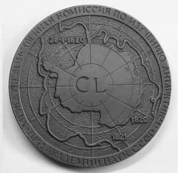
A possible complication was that unlike the Royal Navy the Imperial Navy still observed the old nautical day, which began at noon, twelve hours before the civil day began at midnight, and was divided into a 12-hour p.m. period followed by a 12-hour a.m. period. That meant that in its log books and other internal records anything that took place between noon and midnight was dated one day later than the civil date for the same event. In the 1960s a distinguished historian of polar exploration, Mikhail Ivanovich Belov, concluded that Bellingshausen had used the nautical calendar in the expedition's track charts which he (Belov) was editing, and raised the question of whether traces of it might exist in other documents arising from the expedition. At first Belov applied his nautical calendar hypothesis rather sweepingly to Bellingshausen's book as well as to the charts, and concluded that the date of the (putative) first discovery should be advanced from 28 to 27 January 1820 (Belov Reference Belov1961; Reference Belov1962). That inference was refuted (Lebedev Reference Lebedev1963), and Belov appeared to withdraw it with respect to Two seasons. . . (Belov Reference Belov1963: 19–29). In 1969 he dated the discovery simply to ‘the end of January 1820’ (Belov Reference Belov, Tolstikov, Avsyuk and Korotkevic h1969: 40). The following year, however, he revived the hypothesis in rather bizarre circumstances. On Wednesday, 28 January 1970, the Academy of Sciences and the Geographical Society held a ceremony in Leningrad to celebrate the 150th anniversary of the discovery, complete with a medal (Fig. 1) which enshrined the date as 28 January 1820 (Avsyuk and Kartashov Reference Avsyuk and Kartashov1968). In his lecture for the occasion Belov somewhat negated its purpose by giving the historic date as 27 January 1820 without a word of explanation (Belov Reference Belov1970: 203). Belov's dissent may have been the last outing for the nautical calendar hypothesis from an academically qualified source. Since then scholars have generally ignored it (Pasetskii Reference Pasetskii1981: 102; Koryakin Reference Koryakin and Bellingshausen2009: 16). Meanwhile Belov's original, sweeping application of the nautical calendar to all things Bellingshausen has become enshrined in popular belief, which prefers to think that Russians discovered Antarctica three days before the British, instead of only two. (The hypothesis does remain significant for anomalous passages in the texts.)
Medal issued by the Soviet Academy of Sciences for the 150th anniversary of the discovery of the Antarctic mainland (obverse).

Luckily for the present author, from the opening of his fifth report Bellingshausen made it clear for de Traversay that he was using the civil (Julian) calendar. One sentence, not translated here, even begins ‘On the night of 22/23 [December]’, a phrase that would be nonsensical for the nautical calendar. That said, the sentence in the report for 10 March 1820 (O.S.) may be nautical for the afternoon of 9 March, and the sentence in the report for 21 and 22 March (O.S.) in the latitude of Company Island may be the civil equivalent to one of the rare nautical passages in the book.
Ice
Bellingshausen had been familiar since childhood with the annual formation of marine and river ice in the eastern Baltic, but his recorded experience of marine ice as a sea officer, while serving on the Krusenstern expedition in 1805, was brief and superficial. However a detailed classification of polar marine ice was published at Edinburgh in 1818, and many of its categories were summarised in a book published at London in March 1819 (Scoresby Reference Sementovskii1818; Ross Reference Ross1819 1: lxiv–lxvi). Both are likely to have been among the ‘books from various booksellers’ that Bellingshausen and his officers bought while they were in London from 13 to 22 August 1819 (Bellingshausen Reference Bellingshausen1831 1: 55).
In the early nineteenth century icebergs were referred to in various European languages as ‘ice islands’, ‘ice hills’, ‘ice mountains’ and ‘icebergs’; the evolution of those expressions over 300 years is too complex to summarise here. Perhaps because it was an official document, perhaps under the influence of Cook, Bellingshausen generally used ‘ice island’ in the fifth report. He used the other Russian expression, ‘ice hill’ or ‘ice mountain’, only once and in Cook's preferred context for it, for icebergs observed inside an ice field. Bellingshausen (and later the editors of his book) may have been concerned that ‘ice hill’ would strike a frivolous note, since the phrase also meant an artificial sledge run, a popular form of winter recreation. The author has chosen ‘ice hill’ rather than ‘ice mountain’ to reflect Bellingshausen's respect for Cook and his generally cautious habits of thought. When Bellingshausen wanted to evoke the size of Antarctic icebergs he used a different word altogether (below).
The polymath Russian scientist Mikhail Vasil'evich Lomonosov had already used the terms ‘ice field’, ‘small ice’ and ‘ice hill’ in 1763 (Lomonosov Reference Lomonosov1952). Lomonosov's and Bellingshausen's ‘small ice’ was doubtless the same as Cook's and Ross's ‘loose ice’, but the author prefers not to overtranslate. Lomonosov also referred to ‘ice floes’ and ‘hummocks’, and so did Bellingshausen in his book but not in his reports. Other terms in Lomonosov's vocabulary, such as ‘great ice’, ‘upstanding ice’ and ‘flexible ice’, were not used by Bellingshausen.
Bellingshausen's ‘pieces of ice’ were probably not floes, in the sense of large and flattish fragments of an ice sheet, since he used both expressions in his book, presumably for different things. The Russian word suggests something broken or cut from a larger body. They were probably bergy bits or calf ice, the second of which was explained both by William Scoresby and by John Ross (above).
The expression ‘crowded ice’ was introduced by Scoresby (Reference Sementovskii1818: 324). Bellingshausen used a word that conveys the thickness or denseness of multiple objects, like trees or leaves.
The Russian Academy defined the word translated here as ‘compact’ (another Scoresby word) as ‘having no intervals’ (or ‘interstices’) (Anon. 1793: 911). It is related to a verb which means ‘to join (or place) things closely together (or side by side)’, but it is not the passive participle of that verb, so that the temptation to translate it into Cook's ‘packed ice’ has been resisted. Bellingshausen's ‘compact ice’ was clearly intended, however, to render Cook's ‘field-ice . . . [which] consists of many pieces of various sizes . . . packed close together’ (Reference Cook1777 1: 27). It bears no relation to Ross's ‘packs . . . of ice’ (Reference Ross1819 1: 38), which were smaller floating groups of ice floes. There is also a lexical connection between ‘compact ice’ and a phrase in Lomonosov about large ice floes becoming ‘tightly joined’ with frozen seas in winter (Lomonosov Reference Lomonosov1952: 481). The foreign term ‘pack ice’ may have been imported into Russian during Bellingshausen's lifetime, but the reading is inconclusive (Slovtsov Reference Slovtsov1834: 190). Even if it was, it did not come into wider use until the 1870s. So although ‘compact’ has been applied to a variety of ‘pack ice’ in a modern naval dictionary (Favorov Reference Favorov1994 2: 117), the latter would be an anachronistic translation for the former.
The notion that a ‘continent of ice’ might be encountered in one or other of the two polar regions was a commonplace of European thought at the time. For example it was said that Cook had met southern and northern ice continents on his second and third voyages (Lofft Reference Lofft1781: 216; Schomberg Reference Scoresby1802: 433). In Britain there was a vogue for the phrase just before the Bellingshausen expedition, much of it in response to a paper presented by Scoresby to the Wernerian Society in 1815 (Scoresby Reference Sementovskii1818: 294). The Russians could have purchased another example hot off the press during their visit to London (Freminville Reference Freminville1819: 84). But ‘continent of ice’ had two very different meanings. In most cases it was simply hyperbole. The so-called continents of ice could move around or break up, and several could be contained in an area the size of the Gulf of St Lawrence (Mitchill Reference Mitchill1807: 231).
In its second, more scientific sense the phrase was used by physical geographers and others for the theory that each of the earth's poles was surrounded by a permanent ice cap, an expression which had not yet been coined (Saint Pierre Reference Saint Pierre1784: 195; Crichton Reference Crichton1798: 401; Kant Reference Kant1801: 264). The theory was not universally accepted for the watery Antarctic (Malte-Brun Reference Malte-Brun1812: 430), but a purely hypothetical southern ice cap was strikingly illustrated in a contemporary atlas (Thomson Reference Thomson1817: 3, 7). On board Vostok the expedition's astronomer, for one, endorsed the notion of ‘impenetrable domes which cover the surface of the sea like a crust around both poles’ in an entry in his journal for 19 January 1820, three days after they were turned back by ‘compact ice’ for the first time (Simonov Reference Simonov1822: 178–181). However even such mighty planetary ‘cupolas’ were not thought to have the stable dimensions attributed to land masses; on the contrary they waxed in winter and waned in summer (Saint Pierre Reference Saint Pierre1784: 186–198). So by elevating ice caps into ‘continents’ the savants, of whom Immanuel Kant is the one most likely to have been studied by the then Midshipman Bellingshausen, were adding a decorative metaphor to an idea which had not, in the past, required one (Childrey Reference Childrey1661: 147–149; Lomonosov Reference Lomonosov1847 (1763): 464–465).
Because Russian has no definite or indefinite article it is not immediately clear whether Bellingshausen was claiming, in the fifth report, to have sighted ‘a continent of ice’, that is, an enormous but local body of ice in the first of the two senses just discussed, or ‘the continent of ice’, in other words the south polar ice-cap. But his repeated use of ‘this continent’ in the next sentence, which would have been unnecessary for a unique object, implies the former reading.
But not so fast. Like its English counterpart the Russian word for ‘continent’ was also used for smaller varieties of ‘mainland’ (Armstrong Reference Armstrong1971: 888). The two word phrase ‘main land’ was common, and ‘main’ could be applied to many other things. For a seventeenth century example of ‘main forest’ see (Cherkasov Reference Cherkasov1998: 22). Whether by analogy, by translating either Cook (Cook and King Reference Cook and King1784: 40), of which each ship had a copy, or Ross (below), or simply from normal Russian usage, Bellingshausen and Lazarev came by the phrase ‘main ice’, an expression which had been used in English since at least 1632, well before ‘continent of ice’ came along (James Reference James, Churchill and Churchill1704: 465). But ‘main ice’ had nothing necessarily to do with the proximity of land, main or otherwise. On the contrary, in 1819 John Ross carefully distinguished between ‘Land Ice, ice attached to the shore’, and: ‘Main Ice, a body of impenetrable ice detached from the land, but immoveable, and between which and the ice attached to land, are floes and lanes’ (Ross Reference Ross1819: lxvi – emphases original).
Almost certainly, it was their unfamiliarity with ‘main ice’ that drove previous translators to such shifts as ‘mother-icebergs’ where no word for ‘berg’ was actually present in the text (Bellingshausen Reference Bellingshausen and Debenham1945 2: 417).
The translator is also aware that the ‘x of y’ phrase structure in ‘continent of ice’, which is echoed at one point here by Bellingshausen, had featured in this context with ‘Mayne of Ice’ for Henry Hudson's fifth Arctic voyage of 1611 (Pricket Reference Pricket and Purchas1625: 597). Pricket's phrase was naturally reprinted (Clarke Reference Clarke1806: 105). And it has remained in use, though only for antique effect (Russell Reference Russell1887: 273; Stanley Reference Stanley1947: 16; Covino Reference Covino2005: 152). Its existence makes it difficult to provide a neutral translation of the Russian phrase, so that recourse must be had to the clumsy parallel expression ‘continent/main’.
The phrase about avoiding ice floes by repeatedly falling off the wind (‘bearing up’ or ‘away’) and then luffing back into it, and with it the manoeuvre itself, were probably inherited from Cook (Reference Cook1777 1: 42).
In addition to its Julian dates and its ice vocabulary, the sometimes awkward style of the text has been followed carefully in such matters as the use or omission of capitals, numerals and abbreviations. But two small liberties have been taken. First, in the naval fashion of his day Bellingshausen used abbreviations for the cardinal and intercardinal directions that were written in roman capital letters. It is impossible to capture the original foreignness of that usage in translation because three of the four letters, N, S and W, are the same in English. The fourth one, O, has therefore been translated as E. Second, for the first fifteen pages, out of eighteen, there were no paragraph breaks. Several have been inserted here, and in the same spirit some of Bellingshausen's (or his clerk's) relentless semi-colons have once again been replaced with full points.
Lastly, Bellingshausen was able to dispense with ‘floe’ in the fifth report because he could use the simpler (and vaguer) Russian alternative of putting ‘ice’ into the plural. Since English cannot follow him in that way, an extraneous ‘floe’ or ‘floes’ has sometimes been added. All such interpolations by the author have been placed in square brackets.
Bellingshausen's dispatch from Port Jackson concerning his voyage (extract).
Passing between Bristol and Montagu Islands I set course to the East. Though still sailing through ice, I tried to bear slightly to S. But the further South I came, the more ice islands I encountered. Between the 8th [January 1820] and the morning of the 9th, in dirty weather, we entered ice fields and small ice from which we could only emerge with difficulty by taking a Northerly course, and by repeatedly bearing up and then luffing again, in order to pass the ice. While doing so we could not avoid collisions, which cost us some of the copper at the bow. On Mirnyi sloop the underwater part of her stem was badly damaged in similar collisions, but fortunately the leak held steady.
Sailing on through the ice until the 11th, when it became less frequent, I began making South again. In heavy overcast I sailed on to S., meeting ice no less often than before. On the 16th I advanced to latitude S. 69° 25΄, longitude 2° 10΄ W., where I met compact ice at its fringes, where one [floe] would be dashed to pieces against another. Further in to the South, ice hills were visible at various places within it. From there I was resolved to sail with the ice in sight, in order to get further S., but a contrary wind from E. prevented me from executing my intention. After tacking a short distance East from 19th to 20th I once more moved S. but that time also I met compact ice at latitude S. 69° 20΄, longitude W. 0° 50΄. The wind remained in the East. In view of the violence of the Easterly I made for a somewhat lower latitude, hoping to meet shortly with the westerlies that dominate the middle latitudes in those parts.
On 1 February in latitude S. 64° 30΄, longitude E. 16° 15΄, having gained 17° to E., I turned S. once more in an easterly wind and finally between the 5th and 6th I reached latitude S. 69° 7΄ 30΄΄, longitude E. 16° 15΄. There, beyond the ice fields of small ice and the [ice] islands, a continent/main of ice was sighted, the edges of which had broken away perpendicularly, and which stretched as far as we could see, standing away Southwards like a coast. The flat ice islands that are located close to this continent/main are evidently just detached fragments of this continent/main, since their edges and upper surface resemble the continent/main.
From the 7th I turned S. again, but that time I met the ice sooner. Moreover the winds remained Easterlies throughout whenever one approached the South. For that reason, in order to make some easting, I turned N. again in an East wind in order to pick up the westerlies, and then make another drive to S. On the 14th, lying at latitude 66° 54΄, longitude 41° 33΄, I sighted several ice islands but could see no compact ice. At that point a heavy swell out of the NW and an exceptional calm obliged me to retreat North a little. On the 18th, however, a sudden storm blew up from the E. which carried us yet further North. That frustrated my intention, which had been to reach the latitude at which Captain Cook had met the ice, and then, after observing its present disposition, to bear East along that parallel, turning South wherever possible.
The gale continued until the 21st, after which date the wind consented to bear us East again, and I continued the voyage along a parallel between 62° and 63΄ [a misprint] South latitude. There were gales for most of the time until 27 February, as well as an almost unbroken overcast with snow and frost. Every day we encountered ice islands of various sizes. From the 27th to 1 March a SE wind pushed us some way North. But from that date to the 4th I sailed East through the ice islands in strong South and South-west winds, with snow and almost continual darkness and frost for our constant companions.
On the 4th, at latitude S. 60° 30΄, longitude E. 119° 00΄, I met an increasing number of ice islands, between which the sea was filled with numerous pieces of ice, so that in order to avoid them we were constantly obliged, now to bear away, now to luff up again. Such a passage, late in the season, with the nights growing longer, was extremely dangerous. There was a real risk of disaster, with the murk growing ever thicker and snow falling almost continually, so that even in the middle of the day one could hardly make out any objects more than 50 sazhens [183 m] away. Added to which the equinoctial season was approaching, during which there are storms for most of the time, in which it would be impossible to avoid disasters if we remained inside the ice, within which we had already been sailing for about two weeks, watching the ice islands grow ever more numerous and likewise the pieces of ice in amongst them.
Our passage had lasted 104 days by then, during which the people had endured great hardship, both from the constant gales and from the darkness and foul weather. Due to the frequent snow the sails and rigging were frozen solid for most of the time. From the same cause the steering became not just heavy, but extremely laborious. All those considerations, but mainly the crowded ice that was being encountered and the lengthening nights, persuaded me to foresake the higher latitudes for lower.
But in order for our new course also to be of some benefit to seafarers, I determined to survey a great expanse of ocean, some 10 degrees of latitude and 50 degrees of longitude in extent and hitherto unvisited, lying as it did between the courses taken by Captains Cook and Furneaux. To that end on 5th March I instructed Lieutenant Lazarev to steer 2 degrees South of Captain Furneaux's track and set my own course North of Captain Cook's track by the same amount. I had decided by this means to sweep for company island, discovered by the Spanish, and shown to the South of Vandiemen on Arrowsmith's chart.
On 9th March so great a storm arose that it was impossible to set even a single sail. I lay throughout in the worst possible position within the ice. On the 10th I braced up a single course sail and made between the ice islands. From that date to the 14th we had strong winds, but on the 14th there came a full storm, which rendered our passage within the ice a pretty unpleasant one. On the 16th we suffered another storm, but fortunately it did not last long. From the 21st to the 22nd, running down the latitude of Company island and continuing West of its position, I saw nothing. Nor did Lieutenant Lazarev, passing close to the same position. I conclude, therefore, that either its latitude was taken incorrectly, or the island simply does not exist. On 30th March we reached Port Jackson.
Throughout the length of the passage until we stood into harbour we were never afflicted with sickness. That would have been impossible but for the quality and abundance of our provisioning, both in foodstuffs and in the other necessaries conducive to good health. While Mirnyi sloop was still in high latitudes she lost one seaman who contracted nervous fever [typhoid].
I found no evidence anywhere for a great Southern land, although I held most of my course inside or near the polar circle, as much as the winds allowed. If such a land does exist, it must lie far within the ice and be covered by it, and there would be no way to recognise it. At high latitudes the barometer never rose above 29.35. The thermometer remained at or below the freezing point most of the time, at one time falling to 4° below (Bellingshausen Reference Bellingshausen1823).
Thus far the intrepid Bellingshausen, dictating to his clerk in Vostok's great cabin at anchor off Kirribilli Point, Port Jackson, in April 1820. But the year before he was born another explorer had deposed as follows:
I had now made the circuit of the Southern Ocean in a high latitude, and traversed it in such a manner as to leave not the least room for the possibility of there being a continent, unless near the pole, and out of the reach of navigation (Cook Reference Cook1777 2: 239).
Bellingshausen had not yet completed his own circuit, but his words are so close to those of his admired predecessor that they must have been chosen deliberately.
What he said next
On 21 September 1820 Bellingshausen returned to Port Jackson from the South Pacific and on 2 November he signed his sixth report to de Traversay. Once again there was a long delay, almost five months, before the next mail ship left for England. His sixth report made better time, however, reaching London in May and St Petersburg in June 1821.
What appears to be a summary of the sixth and seventh reports, from Port Jackson and Rio, with additional points possibly taken from (Anon. 1821a), was published at St Petersburg in September 1821, after the expedition had returned (Anon. 1821c). The only published versions of the texts of those two reports are those in the Dokumenty. The sixth was presented as an extract with three cuts marked in its text (Samarov Reference Samarov1952: 169–172). The seventh, dated from Rio 17 March 1821, had one cut marked but no ‘From’ in the title (Samarov Reference Samarov1952: 196–198). Neither the 1821 summary nor the versions published in 1952 added anything to the account of the expedition's first Antarctic phase of exploration, in 1820, that was given in the fifth report (above).
In particular, Bellingshausen did not use his later reports to qualify his statements in the fifth report and its covering letter (above), to the effect that during his first season, in 1820, he found no signs of land in the far south. He did, however, modify that conclusion slightly some years later. First, in the covering letter he had emphatically rejected all his sightings of birds as evidence for the proximity of land, and explained why. But eleven years later, in his book, he allowed that a few of the birds had been from land-dwelling species after all, especially some that were seen, but unfortunately not collected, between 19 and 25 February 1820 (Bellingshausen Reference Bellingshausen1831 1: 193–200). It was an interesting amendment, and there is no knowing why he made it. Presumably it resulted from talking to other expedition members or reading their journals. Dr Nikolai Alekseyevich Galkin, the surgeon on Mirnyi, had some knowledge of ornithology and may have been involved. But unfortunately the first part of his memoirs, covering the first phase of the expedition, was dispensed with by the editor of Syn’ Otechestva (Galkin Reference Galkin1822).
Bellingshausen also modified his account of what he saw on 17 February 1820. In the fifth report his description of the ‘continent of ice’ was unclear. Because he had just directed the reader's attention to the ice cliff, and then left out a word meaning ‘gradually’ or ‘increasingly’ which often accompanies the verb he used, he could be taken to mean something high and vertical which simply stretched away without getting any higher, like a city wall or the edge of a forest. The translation ‘standing away Southwards like a coast’ (above) reflects that admittedly cautious reading. In his book, however, he carefully revised the passage to explain that it was indeed the upper surface of the ice that had risen away towards the south. But there was more, and since this sentence appears for once to have been under-translated and generally overlooked it is worth giving in full:
To SSW the floes lie up against mountainous [or ‘hilly’] ice, which stands firm. Its edges were perpendicular and took the form of coves, and its upper surface rose in a slope to the South for a space the limits of which we could not make out from the cross-trees (Bellingshausen Reference Bellingshausen1831 I: 189).
His initial use of the present tense, to indicate a permanent situation, was enough in itself to make this passage significant.
Despite having witnessed such scenes Bellingshausen never changed his mind about what he saw as the main question, when and where he had discovered land. A St Petersburg journalist visited the squadron when it got back to Kronstadt in August 1821, heard what had been achieved and studied the maps of the cruise which were to be displayed before the Tsar a few days later. Just like Bellingshausen and (later) Simonov, he reported that the squadron had found nothing between leaving the South Sandwich Islands and reaching Australia (Anon. 1821a). That story went unchanged and unchallenged anywhere until 1949.
Temporary glasnost
Shvede was familiar with the fifth report. In his introduction to the second edition of Two seasons. . . he mentioned the important southing in February 1820 that was recorded only in the fifth report and not in the book (Shvede Reference Shvede and Shvede1949: 26). In the third edition he quoted the passage directly (Shvede Reference Shvede and Shvede1960: 37). By then the Soviet Union had secured its immediate political goals in Antarctica through the Antarctic Treaty, and over the next few years the negative passage about the 1820 season in the fifth report was mentioned a few times. The historian Belov and the geographer Vladimir L'vëvich Lebedev were prominent in this short-lived glasnost. Lebedev was the first to mention that Bellingshausen had denied discovering an Antarctic mainland in 1820 (Lebedev Reference Lebedev1960: 23–24). A year later he and Belov both quoted Bellingshausen's denial directly, either in part or in full, from the shorter report version rather than from the covering letter (Lebedev Reference Lebedev1961: 136; Belov Reference Belov1962: 106). Belov even drew attention to the close parallels between Bellingshausen's assessment of his first season and the earlier conclusions of James Cook, whom Shvede and others had taken every opportunity to compare unfavourably with Bellingshausen for the past thirteen years (Shvede Reference Shvede and Shvede1949: 26).
Despite acknowledging what they sometimes referred to as Bellingshausen's ‘reservation’ in the fifth report, Belov and Lebedev still conformed to the official paradigm of Russian priority. They needed to show, therefore, that Bellingshausen had discovered Antarctica in January 1820 even though he believed that he had not done so. They responded to the challenge with a ‘goalposts’ argument, which asserted that because much of the rocky Antarctic mainland is bordered with large and permanent or semi-permanent ice shelves, an encounter with such ice was tantamount to an encounter with the mainland, even if the explorers involved did not see things that way at the time. On other matters, however, the arguments of Belov and Lebedev diverged.
Belov appears to have felt that Bellingshausen's own modest account of 28 January 1820, which reduces to ‘icebergs in an ice field’, was not strong enough to support a claim to first discovery. His usual preference was to quote Lazarev's description of an encounter with ‘main ice’ on 28 January (Lazarev Reference Lazarev1918: 55), or 27 January according to Belov, and then to support that passage with Bellingshausen's sighting of ‘a continent of ice’ in mid-February 1820 (too late for first discovery) (Belov Reference Belov1961: 11, 13, Reference Belov1963: 45, Reference Belov1970: 204).
Lebedev also valued those two passages, but unlike Belov he regarded Bellingshausen's record of sighting icebergs on 28 January 1820 as a ‘successful observation’ of the Antarctic mainland in itself (Lebedev Reference Lebedev1960: 20, 14). He repeated the claim in response to an enquiry from New Zealand the following year. That article was published in English as well as Russian, and it shows that Lebedev liked to think of Bellingshausen's icebergs as ‘ice mountains’ at least, and perhaps as something more substantial (Lebedev Reference Lebedev1961: 162).
To understand Lebedev's thinking we need to step back once more to Cook, because at the time he was writing about Bellingshausen, Lebedev was also co-editing a translation of the new Hakluyt Society edition of Cook's second voyage. Cook used all three iceberg terms available to him, ‘islands’, ‘hills’ and ‘mountains’, but not indiscriminately. Most of his icebergs were called ‘ice islands’. He used ‘ice hill’ at two points, for icebergs seen inside an ice field. And he reserved ‘mountain’ either for an iceberg large enough to be mistaken for land, or else, with an added ‘huge’ or ‘prodigious’, to emphasise the vastness of Antarctic icebergs as compared with their Arctic counterparts (Cook Reference Cook and Beaglehole1961: 321, 323).
‘Ice island’ presented no difficulty to a translator. But the usual Russian word for elevated land, ‘gora’ (plural ‘gory’), covers anything from the Himalayas to the Sparrow Hills in Moscow, which rise only 70 m above the river. The word has even been used for ‘ice hills’ as small as three to five metres in height (Segodnya (Riga) 10 February 1922). But Lebedev and his colleagues took steps to avoid confusing Cook's ‘hills’ with his ‘mountains’. They allocated the rather more literary word ‘holm’, which means something like ‘hillock’ or ‘knoll’, not only for Cook's ‘ice hills’ but for most of his ordinary land hills as well. By straining the vocabulary in this way, ‘gory’ in polar contexts could be reserved for his ‘mountains of ice’ (Cook Reference Cook, Morozovskii and Lebedev1964: 285).
Lebedev may also have been influenced by the infrequency of Bellingshausen's use of ‘ice hills’ (‘gory’) for icebergs, which was touched on above. The fact remains that ‘ice gora’ was a normal Russian expression in the eighteenth and early nineteenth century, whereas ‘ice holm’ was rare. Only one, latish occurrence could be traced in this period (Wrangel Reference Wrangel1841: 315). For an appropriate translation of Cook, therefore, it might have been better to retain ‘gora’ for his ‘ice hills’ and to find another way to convey the impression of size that was intended with his less frequent ‘mountains of ice’. The Russian word ‘gromada’, for instance, meaning ‘huge mass’, was used for Arctic icebergs as early as 1817 and by Ferdinand von Wrangel on the next page after ‘holms’ (Karamzin Reference Karamzin1817: 235; Wrangel Reference Wrangel1841: 316). Added to which Bellingshausen used ‘gromada’ himself, more or less in Cook's sense of ‘ice mountain’, in the covering letter, where it was translated as ‘huge masses of ice’ above (Bellingshausen Reference Bellingshausen1821b). Lebedev knew that text because he cited it. To sum up, turning Cook's ice mountains into ‘gory’ and his ice hills into hillocks enabled Lebedev to nudge Bellingshausen's ‘gory’, the ice hills seen on 28 January 1820, towards the English word ‘mountains’, a designation which Lebedev then flagged up as ‘very important’ (Lebedev Reference Lebedev1960: 14). The point of this lengthy analysis will become clearer in the next section.
Lebedev quoted Bellingshausen's negative self-assessment again in 1963, but that year Belov restricted himself to a vague complaint about the cuts in published versions of primary documents (Lebedev Reference Lebedev1962: 177; Belov Reference Belov1963: 10). After 1964 (Yesakov Reference Yesakov1964: 61), the author has found only one further reference to Bellingshausen's own, politically inconvenient, opinion of his 1820 season. In the text volume of the Soviet Antarctic Atlas Belov argued that Bellingshausen's remarks were only meant to underline his inability to confirm the existence of Cook's hypothetical ‘Sandwich Land’, and were not directed at his search for Antarctic land in general (Belov Reference Belov, Tolstikov, Avsyuk and Korotkevic h1969: 39–40). Readers can evaluate that interpretation for themselves from the translations above.
The limits of the temporary glasnost accorded to Bellingshausen's denial that he discovered an Antarctic mainland in 1820 are evident in various ways. First, the issue was quickly dropped. Belov may have reprised it in 1969, but he did not trouble the anniversary celebration with it in 1970 (Belov Reference Belov, Tolstikov, Avsyuk and Korotkevic h1969; Reference Belov1970). After 1963 the journal of the Antarctic Commission of the Academy of Sciences, in which Lebedev's contributions had appeared, suddenly stopped publishing original research into the Bellingshausen expedition. For the next 45 years such work is far to seek in other Russian journals also. A rare example was concerned with the uncontroversial Pacific phase of the expedition (Kabo and Bondareva Reference Kabo and Bondareva1974). Next, the complete covering letter, with its more fulsome denial of an 1820 discovery, was never published; nor was the full text of the fifth report republished. Nor have they been to date. (The limited versions of both documents that appeared in Syn’ Otechestva in 1821 first resurfaced on the internet in 2009 and were finally reprinted while this article was being revised (Bellingshausen Reference Bellingshausen2009; Reference Bellingshausen, Tereshina and Zhemerova2011)). Thirdly, a facsimile of the fifth report has been on display at the Arctic and Antarctic Museum in St Petersburg for about fifty years, according to curators. But the exhibit does not contradict what has just been said. With the exception of two pages, 1 and 8, the rest are displayed in pairs with one page overlapping about half the following one. Few visitors are likely to read through such an interrupted text. Should they read it, they do not meet the words ‘I found no evidence anywhere for a great Southern land’, which happen to fall in the overlapped part of page 12. Just as they were in the Dokumenty (Samarov Reference Samarov1952), they have been redacted.
Discussion
Texts
Previous foreign commentators on the Bellingshausen expedition, such as Frank Debenham or A.G.E. Jones (Reference Jones1982), examined few primary sources apart from Two seasons. . . A translation of the 1831 edition of Two seasons. . . was completed for Debenham in the 1920s. It contains several errors, some of which may have crept in at the editorial stage, but its appearance in 1945 was a great achievement (Bellingshausen Reference Bellingshausen and Debenham1945). The most serious blunder, perhaps, came in the entry for 6 February 1820 (O.S.). A few lines after rendering ‘ice hills’ as ‘icebergs’ in the usual way the translation and its editor somehow managed to transform some more ‘ice hills’, which Bellingshausen specifically stated were just like the preceding ones, into ‘ice-covered mountains’ (Bellingshausen Reference Bellingshausen and Debenham1945: 128–129). Russian has a word for ‘ice-covered’ but Bellingshausen did not use it here. Debenham's introduction and notes were otherwise generally shrewd, but their limited scope reflected the dearth of scholarship on the expedition in the first half of the twentieth century.
Jones approached the Bellingshausen expedition in less fortunate circumstances. As Belov had pointed out, a comprehensive study was probably beyond the resources of a small research team, let alone successive individual efforts (Belov Reference Belov1963: 8). Jones's work reveals by default that, far from such a project, by the 1970s there were few if any Russian experts still working on the subject with whom he could correspond. Authorities differ as to whether the complete text of Simonov's shipboard journal survived, but if it did it had not been published. The fate of his unpublished astronomical and meteorological observations had not (and has not) been determined. The text of Kiselëv's journal was in dispute and in most versions heavily cut. Known textual problems in Two seasons. . . had not (and have not) been tackled in a scholarly edition. And historical questions such as the meanings of key expressions or the relevance of the naval calendar had been left where they stood in the 1960s, instead of being followed up in a rigorous and open-minded way. The combination of that situation with Jones's legitimate but narrow focus on the discovery question, and personal lack of Russian, gave rise to several difficulties.
If Jones had been better advised he would not have accepted Belov's substitution of 27 January for 28 January 1820 after it had been rejected by the Academy of Sciences. But his main difficulty lay in understanding the texts. A footnote shows that his translator or translators (the number is unclear) were content to read early nineteenth century prose as if it had been written in the twentieth century and as if every important word had only a single meaning (Jones Reference Jones1982: 104). There were several typos and minor slips, such as taking a noun for an adjective, but Jones's first real problem came, predictably, with icebergs.
Somehow, perhaps influenced by Lebedev's preference for ‘ice mountains’ or by Debenham's ‘ice-covered mountains’ and perhaps simultaneously misled by a literal translation of the Russian phrase for ‘ice hills’, Jones became persuaded that Bellingshausen had reported seeing, not icebergs or even ‘ice mountains’, but ‘icy mountains’ on 28 January 1820 (Jones Reference Jones1982: 92, emphasis added). He did not compare the text with Bellingshausen's descriptions of South Georgia, the Traversay Islands, and the Alexander I Coast. If he had done, he would have seen that although Bellingshausen sometimes gave details about where ice and snow were lying he never described real Antarctic mountains as merely ‘icy’. But luckily Jones discounted the idea that Bellingshausen had seen real mountains on 28 January 1820 anyway, because of the distances involved.
Jones proceeded to adopt the ‘ice shelf’ criterion for discovering the Antarctic mainland, which of course is perfectly legitimate. His assessment of 28 January 1820 was less so, however, because he not only relied on an overtranslation of Lazarev's ‘main ice’ into ‘continental ice’, but also preferred that presumed allusion to an ice shelf, not only above Bellingshausen's ‘icy mountains’ which he had discounted, but also above two other accounts of the day, neither of which mentioned an ice shelf or ice barrier (Jones Reference Jones1982: 92).
For the later probes of 1820 Jones was hampered by an overtranslation of the fifth report, which unlike Two seasons. . . (above) did not say in terms that what was seen on 5 February 1820 (O.S.) became ‘higher towards the south’ (Jones Reference Jones1982: 99). And curiously, he quoted Debenham's commentary on the so-called ‘ice-covered mountains’ at length, but neither discussed nor accepted his predecessor's interpretation. But those are side issues. Applying his ice-shelf criterion, Jones made a strong case for a post-Smith and Bransfield sighting in February 1820. Less convincingly, he went on to decide that ‘Bellingshausen was the first to sight the Antarctic continent’, in other words in January 1820 (Jones Reference Jones1982: 101). That meant he was pinning everything on Lazarev's solitary use of ‘main ice’ for 28 January 1820, a term that was sufficiently discussed above. Since Jones, another historian has concluded that Bellingshausen:
. . . sighted but did not recognize as land two coastal areas in Kronprinsesse Mårtha Kyst and Prinsesse Ragnhild Kyst (the first sighting was on 27 January 1820, three days before Edward Bransfield's discovery of Trinity Peninsula). . . (Headland Reference Headland1989: 115; see also Mills Reference Mills2003: 27).
That statement goes some way beyond Debenham and Jones, but apart from Belov for the date its Russian sources are unclear. Secondary sources of the calibre of Debenham, Jones and Headland can sometimes overawe the careless researcher (see for example Bulkeley Reference Bulkeley2011: 141). Primary sources, some treated here, tell a more complex tale.
Discovery
Discovery, as the word implies, consists not only in finding knowledge but also in sharing it. What remains untold remains undiscovered. Imperialist governments and profit hungry commercial companies sometimes restricted the dissemination of new geographical information because of its potential value. But unless those facts had been ‘discovered’ to them in the first place they could never have taken their selfish measures. Bransfield reported seeing ‘Trinity Land’ quite promptly (Mills Reference Mills2003: 27), for example, and the Antarctic Peninsula became familiar to mariners under that name (and others) in the 1820s (Webster Reference Webster1834: 135).
What Bellingshausen and his comrades saw in 1820 has often been discussed. What they told people about it was just as important and merits a separate assessment. Bellingshausen gave the coordinates for all his surveys and discoveries in a final report on the voyage that has never been published (Bellingshausen Reference Bellingshausen1821a). Most were quickly communicated to the world of learning. Their coordinates were published in French in the 1820s (Simonoff Reference Simonoff1823, 1824a; Sommer Reference Sommer1823; Krusenstern Reference Krusenstern1824, 1827). However Simonov did not claim discovery for the islands in the South Shetlands, ‘Borodino’, ‘Leipzig’, ‘Smolensk’ etc. which Bellingshausen so named when he charted them towards the end of the voyage. Bellingshausen described them carefully in his book, which included his chart of the group, dated 1821, in the Atlas volume (Hobbes Reference Hobbs1939: Plate VI). But neither in his final report (above) nor in the book did he claim them as discoveries. He had evidently needed a way to identify them as he surveyed them, and despite his celebrated encounter with the American sealer Nathaniel Palmer he probably did not have detailed information about prior British knowledge of the group. In 1824 Ivan Fedorovich Krusenstern turned to the British names for his Atlas de l'Océan Pacifique (Hobbes Reference Hobbs1939: Plate VII). This harmless instance of exploration overlap was to be used for cold war purposes in the twentieth century (Grigor'ev and Lebedev Reference Grigor'ev and Lebedev1950: 17; Shvede Reference Shvede1952: 23; compare Purdy Reference Purdy1822: 38–39 with map).
Turning to the matter of ice shelves, neither the report in Syn’ Otechestva nor Simonov gave any details of the encounters with ‘main ice’ or a ‘continent of ice’ in February, but as we have seen Bellingshausen reported them promptly himself and repeated them in his book (Reference Bellingshausen1823; Reference Bellingshausen1831). Since what was seen was duly recorded and communicated, the expedition's achievements in February 1820 are candidates for the status of discovery. The briefer exploration of ice fields in January 1820 is on less solid ground; first because Lazarev was the only witness, out of four, to claim that ‘main ice’ was encountered on 28 January 1820; second, because if he was using ‘main ice’ in its contemporary technical sense it was not or may not have been, in his opinion, land ice; and third, because instead of lodging his statement with an official custodian of knowledge such as the Imperial Navy he sent it privately to a friend and it was not published until 97 years later.
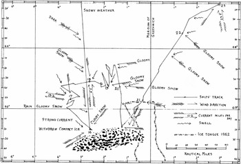
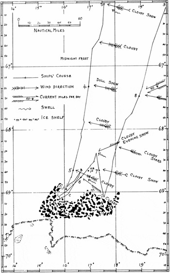
There are two documents that at first sight suggest that the ice exploration on 28 January 1820 may after all have been reported in terms that would qualify it as an ice-shelf discovery. The first is Lowe's rendering of what was seen that day as ‘eine dichte Eismauer’ (‘a compact ice-wall’) (Lowe Reference Lowe1842: 138). However Lowe's version of the February probes shows that he was not careful with his terminology, and his language may suggest an ice barrier simply because he had seen an early report of James Clark Ross's discovery of the Ross Ice Barrier. The second, more reliable document is Bellingshausen's track chart, a fair copy of which was drawn on several sheets and deposited with the Russian Admiralty soon after the expedition. At first glance the sections for 28 January and 17 February 1820 (Figs. 2, 3) suggest that Bellingshausen, the expert hydrographer, recorded the ice encountered on both days as fairly similar, even if Bellingshausen, the narrator, described it differently (Jones Reference Jones1982: 90, 96). Unfortunately not even the track chart is conclusive. Careful examination shows, first, that the expedition turned back before entering the ice in the first case but penetrated some distance within it on the second occasion; second, that even Bellingshausen was not above placing a large amount of ice on the chart that, without a helicopter, he cannot possibly have known was there; and third, that Bellingshausen may have drawn a swarm of massive ice islands at each position, but he did not depict a ‘continent of ice’, let alone the ‘continent of ice’, at either. His drawings appear, therefore, to conflate the ice he had seen at those points both with the large tabular icebergs he had seen to the north of them, and with the highly plausible 160 year old theory that he had brought along with him (Thomson Reference Thomson1817: 3, 7).
Bellingshausen's track chart for 28 (16) January 1820 (Jones Reference Jones1982: 90).

Bellingshausen's track chart for 17–18 (5–6) February 1820 (Jones Reference Jones1982: 96).

On balance then, the Russian expedition did not unambiguously (1) decide and, (2) place on record that it had encountered an ice shelf on 28 January 1820. But it did report coming up against a continent or main of ice in mid-February 1820. If we accept that ice shelves and ice tongues are part of the Antarctic mainland we should conclude that the Russians discovered the mainland independently in February 1820, but not in January.
Politics
Although no official Soviet documents have been cited in this article, there seems little room to doubt that the inconvenient paragraph in Bellingshausen's fifth report, and his even more inconvenient covering letter, were downplayed and largely disregarded during the cold war because the Soviet government wanted to claim that Russian seamen, not Spanish, Dutch, American or British seamen, had been the first people to discover the mainland of Antarctica. Not for the first or last time in human history, the past was subordinated to the needs of the present. At least, if there is another explanation for the facts presented above, the author has not been clever enough to guess what it may be.
The brevity of the Syn’ Otechestva version of Bellingshausen's fifth report may be the reason why it was not re-published in the Soviet Union. If the sensitive passages had been removed from both its sections only a stub would have been left. The full text, as published in 1823, could withstand a small cut and so could be included in the Dokumenty.
But, was there really a problem? The treatment of the fifth report, especially from 1949 to 1961, is now part of history itself, pertaining to a bygone era. But before we ascribe it to the insecure obsession with Russian superiority and priority in all things which was the cultural hallmark of late Stalinism, certain facts should be recalled. First, the United States did launch an attempt, in 1948, to secure exclusive western control over Antarctica. Second, in 1949 the Warsaw Pact had not even been thought of and the Chinese People's Republic had barely come into being. The Soviet Union was still almost as isolated on the world stage as she had been in 1935. And third, the Soviet Academy of Sciences did not receive an invitation to take part in the International Geophysical Year (IGY), which quickly became a far more effective vehicle for Soviet Antarctic policy than aggressive diplomacy, until the end of 1952 (Bulkeley Reference Bulkeley2008).
All that said, those who drew a veil over Bellingshausen's inconveniently negative evaluation of his first season were taking unnecessary precautions. Even if his views about 1820 had been fully and freely acknowledged the Soviet Union would have had, and Russia today still has, an indefeasible claim to political rights in Antarctica on two grounds: the Bellingshausen expedition taken as a whole, and her status as a permanent member of the UN Security Council. The IGY rapidly became a third. Added to which, when the United States and her allies finally conceded the Soviet Union's political point in the late 1950s, their decision was reached without paying any regard to Bellingshausen's supposed priority.
In the author's opinion, absolute historical priority in Antarctica was and is politically irrelevant. Antarctic historians have long been aware that an unidentified European voyage in the late sixteenth or very early seventeenth century may have reported seeing land somewhere south of Cape Horn at 64° S. The consensus has been that, if so, it was either the South Shetland Islands, which are part of the continent of Antarctica in a widely-used sense of the word, or the Antarctic Peninsula, which is part of the mainland of that continent (Balch Reference Balch1902: 40–53). A more recent review of the archival evidence for early Dutch and Spanish voyages in the region concluded that we are unlikely ever to know exactly what was reported or by whom (Berguño Reference Berguño1991: 152; for a more sceptical view, see Headland Reference Headland1989: 59–60). And for once, let history leave the matter there.
Conclusions
Eighteenth and nineteenth century maritime explorers evidently set themselves a ‘rock and dirt’ standard for discovery. There can be no objection to viewing the Bellingshausen expedition from an ice-shelf perspective instead, provided that the logical consequences of doing so are understood and accepted. The first consequence is that if Smith and Bransfield on the one hand and Bellingshausen on the other are now entered for different events so to speak, call them ‘rock mainland’ and ‘ice mainland’ respectively, there is no longer much point in dwelling on the order in which they completed them. Even if we do not accept that Bellingshausen discovered anything on 28 January 1820, we might still conclude that Bransfield's sighting ot the Antarctic Peninsula was of less historical significance than either Smith's earlier or Bellingshausen's later discoveries. If on the other hand, against the run of the evidence, we accept 28 January 1820 as an ice discovery of the mainland, we might still maintain, especially nowadays, that Smith's and Bransfield's rock is more substantial and enduring than Bellingshausen's ice. The effective reporting of the British discovery is another relevant consideration.
The other consequence of viewing Bellingshausen from an ice perspective is that his true rival turns out to be, not Bransfield, but Cook, who just like Bellingshausen reported seeing:
. . .solid ice in one continued compact body . . . [which] seemed to increase in height, as you traced it to the South; in which direction it extended beyond our sight (Cook Reference Cook1777 1: 267);
and furthermore went on to state:
That there may be a continent, or large tract of land, near the Pole, I will not deny; on the contrary I am of opinion there is; and it is probable that we have seen a part of it (Cook Reference Cook1777 2: 192).
which is more than Bellingshausen was prepared to say.
The possibility that Cook discovered the mainland of Antarctica has been rejected, mainly on the grounds of his recorded positions (Jones Reference Jones1982: 28–58). There seems to be no scientific consensus as to the effects of the Little Ice Age on Antarctic ice shelves, but all the same it is unfortunate that Jones did not take that factor into consideration. If he had done, he might have noticed that he was applying a tough ‘rock and dirt’ criterion to Cook but a more generous ‘ice shelf’ criterion to Bellingshausen (1982: 52–53, 101).
Lastly, Bellingshausen's work in the Pacific was thoroughly documented and analysed by Glynn Barratt in the last century (Reference Barratt1979, Reference Barratt1992). The story told here of the treatment of the fifth report is only one example of the research and publication deficit which continues, by contrast, to handicap the expedition's equally important Antarctic phases. Primary sources remain unpublished or only part published, issues unresolved, debates suspended. The last complete, scholarly edition in Russian of a previously part published Bellingshausen text was more than twenty years ago (Aristov Reference Aristov1990; but see also Govor and Massov Reference Govor and Massov2007: 52–75). Meanwhile public interest in the expedition continues to rise. A historical novel was published ten years ago (Fedorovskii Reference Fedorovskii2001), and two popular editions of Bellingshausen's narrative have appeared in the last four years. One can only hope that academic historians will soon come forward to meet the growing need for their services.
Bellingshausen has remained a largely unexamined political symbol for too long. If we look carefully at everything he said and the contemporary technical language he used to say it, we can start to rediscover a great Antarctic explorer on his own terms.
Acknowledgements
All Bellingshausen research today is indebted to the Russian State Library for making available a fully searchable scan of the first edition of Two seasons. . . This article could not have been written, either, without the online resources provided by Google Books, the Internet Archive, and Gallica, or the efficient copying services of the National Library of Australia and the Russian National Library. The Naval Historical Branch, Ministry of Defence, kindly provided clarification on the representation of the nautical calendar in early track charts, and Caedmon of Whitby felt sure that Jones would have been pleased that his maps were useful. On a more personal level, the author is grateful to Yrjö Kaukiainen, of the University of Helsinki, for his expert opinion on the route across Europe likely to have been taken by Bellingshausen's fifth report. And he would especially like to thank Irina Lukka, senior librarian at the Slavonic Library of the National Library of Finland, the bookseller Alexander Chekulayev of St Petersburg, and the historian Valentin Smirnov, also of St Petersburg, for their generous assistance. Needless to say none of those mentioned bears any responsibility for the hypotheses and interpretations advanced above.