

Introduction
The Late Chalcolithic period (c. 4500–3000 bc) in north Mesopotamia witnessed profound transformations: the emergence of proto-urban centres, the development of administrative technologies and the intensification of craft production all preceded the expansion of inter-regional networks culminating in the Uruk phenomenon; the appearance of southern Mesopotamian cultural elements across the region (Algaze Reference Algaze1993; Rothman Reference Rothman2001a; Stein Reference Stein1999a). Although interpretations have generated considerable debate, existing models share a fundamental limitation: they conflate temporal scales.
Algaze’s (Reference Algaze1993) ‘Uruk World System’ model proposed that southern Mesopotamian groups established colonial networks to exploit northern resources, treating 700 years of complex interaction as a single ‘expansion’ event. Stein (Reference Stein1999a) challenged this with alternative models by emphasizing ‘distance-parity’ and ‘trade diasporas’; however, these focus on synchronic ‘peer-polity interaction’ without adequately addressing the diachronic trajectories that produced the social structures enabling such interactions. Helwing (Reference Helwing1999) highlighted the concept of cultural ‘hybridisation’, which usefully describes outcomes but fails to explain how processes operating at different temporal rhythms produced such diverse regional responses. Recent studies emphasize indigenous northern complexity before southern contact (e.g. at Tell Brak: Oates et al. Reference Oates, McMahon, Karsgaard, Quntar and Ur2007 and Hamoukar: al-Quntar et al. Reference al-Quntar and Khalidi2011), yet these interpretations remain largely one-dimensional, focusing principally on Uruk expansion rather than placing it within longer-term historical processes. Recent ceramic network analysis confirms that LC 1 reflects gradual regionalization beginning in Ubaid 4 rather than a sudden cultural break, underscoring the need for diachronic frameworks integrating multiple temporal scales (Abu Jayyab & Gibbon Reference Abu Jayyab and Gibbon2022, 30–33).
This temporal conflation leads to a clear critical issue. Archaeologists often treat long-term processes unfolding over centuries or even millennia, such as urbanization, craft specialization, or the rise of administrative systems, as if they were directly comparable to, or even causally equivalent to, short-term events that take place over decades, like the establishment of colonies or the destruction of sites. As a result, explanatory models tend to favour one side over another: structure over agency, indigenous development over external contact, continuity over change. Yet the archaeological record shows that all these forces were at work simultaneously, operating on different temporal scales (Bintliff Reference Bintliff and Bintliff1991, 7–8).
This article explores an alternative framework for the Late Chalcolithic in northern Mesopotamia by integrating Fernand Braudel’s philosophy of history. As a cornerstone of the Annales School, Braudel challenged linear narratives by introducing a tripartite temporal perspective. At the base of this model lies the longue durée (geographical time), representing the near-static environmental forces underpinning human history over millennia. Intersecting this are the more rhythmic cycles of conjoncture, which track demographic shifts, economic patterns, and social evolution. Finally, the événement captures the immediate, often fleeting nature of specific historical events. Rather than treating these layers as fragmented sequences, Braudel’s concept of ‘histoire totale’ demands an understanding of their deep-seated interconnectedness, in which phenomena across all temporal scales occur simultaneously (Braudel Reference Braudel and Reynolds1972, 20–21).
The use of the Annales method in archaeology is applicable across various regions and periods. Barker (Reference Barker and Bintliff1991) employed Braudel’s paradigm to analyse settlement patterns in the Biferno valley, while Knapp (Reference Knapp and Knapp1992) applied it to the Bronze Age southern Levant. However, no study has systematically applied temporal plurality to the Uruk phenomenon, the defining issue in Late Chalcolithic archaeology. This represents a significant gap, as the Uruk debate exemplifies precisely the kind of temporal conflation that Annales methodology can resolve.
The Late Chalcolithic in northern Mesopotamia benefits from an Annales approach given its diverse archaeological record. The region’s geography, including the Jazira plains, eastern Anatolian highlands and Tigris–Euphrates valleys, influenced settlement patterns and subsistence strategies over the millennium, enabling ‘structural possibilities’. Medium-term social transformations—population growth and the rise of workshops and administrative practices during LC 1–2—shaped regional exchange networks and responses to southern influences. The Uruk phenomenon illustrates this conjoncture, as it unfolded over approximately 700 years (c. 3700–3000 bc) with varying cultural elements appearing in northern Mesopotamia. Specific historical events, like the establishment and abandonment of Uruk colonies, punctuated this long trajectory, highlighting the interplay between geographical structures and social developments.
This article examines north Mesopotamia—the Middle and Upper Tigris regions, the Middle and Upper Euphrates regions, the Altınova Plain, the Balikh basin, the Erbil Plain, and the Iraqi Jazira. This analysis draws upon excavation data from more than 30 sites and regional surveys (Fig. 1). According to the Santa Fe chronology, the Late Chalcolithic sequence comprises five phases (LC 1–5) (Figs 2–3) (Rothman Reference Rothman and Rothman2001b), spanning from c. 4500 bc (terminal Ubaid/LC 1) to c. 3000 bc (Late Uruk/LC 5). Particular attention is given to LC 1–2 (c. 4500–3700 bc), receiving less scholarly attention than subsequent Uruk-related phases, despite constituting over 700 years of cultural development. This neglect itself reflects the problem of temporal conflation, as this extended indigenous trajectory provides essential context for understanding later southern contact.
Map showing the main LC sites mentioned in the text (prepared in QGIS).
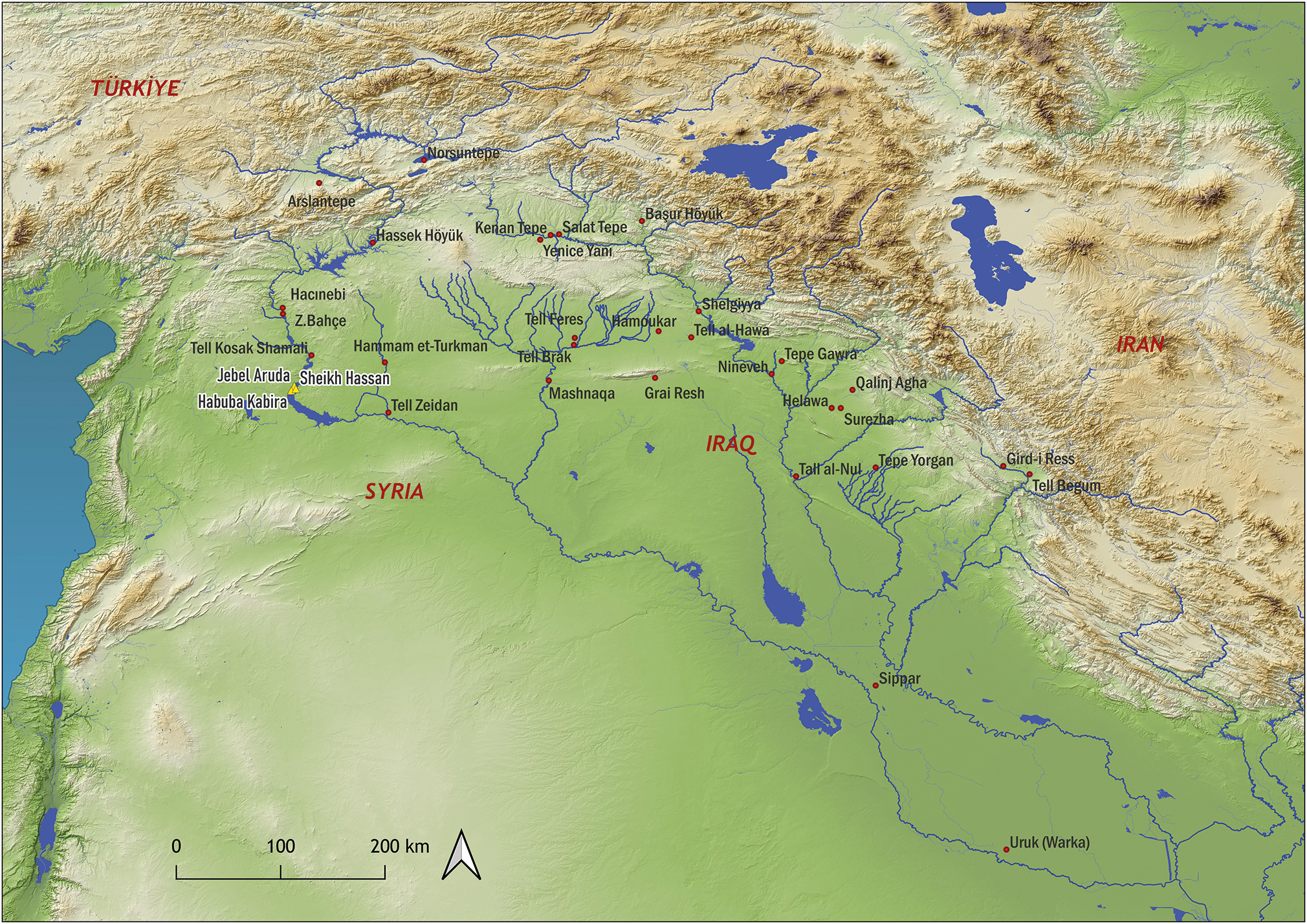
Figure 1 Long description
A map showing the main LC sites mentioned in the text, prepared in QGIS. The map covers a region including parts of modern-day Turkey, Syria, Iraq, and Iran. Key labeled locations include Arslantepe, Hassek Hoyuk, Tell Kosak Shamali, Hammam et-Turkman, Tell Brak, Tell Zeidan, Tell Brak, Nineveh, Tepe Gawra, Tall al-Nu, Sippar, and Uruk (Warka). The map highlights various archaeological sites and their spatial relationships within the region. The map uses a topographic style to show elevation and geographic features, with rivers and other natural features clearly marked. The purpose of the map is to illustrate the distribution of significant archaeological sites related to the Uruk World System model and subsequent research.
Northeast Mesopotamian sites and related LC levels. (After Rothman Reference Rothman and Rothman2001b, table 1.1.)
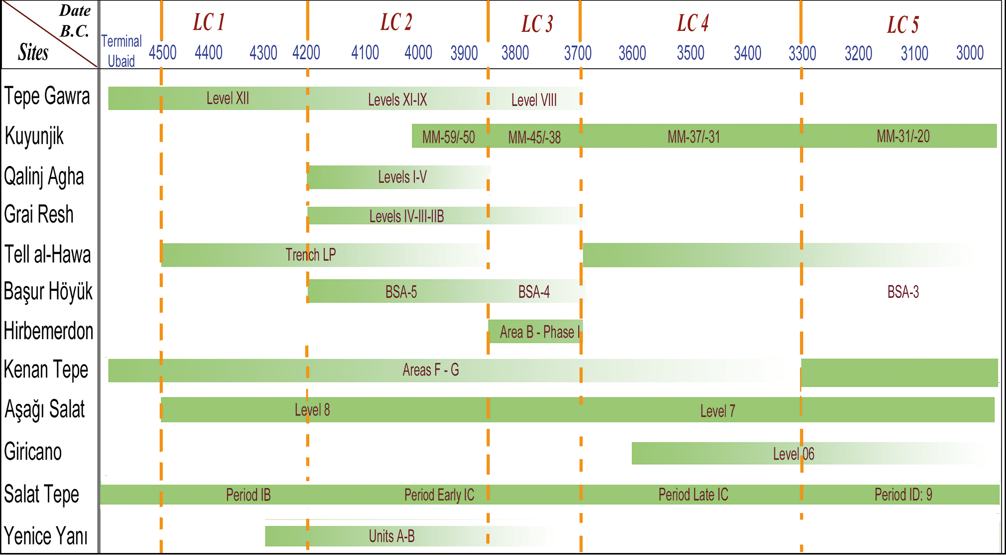
Northeast Mesopotamian sites and related LC levels. (After Rothman Reference Rothman and Rothman2001b, table 1.1.)
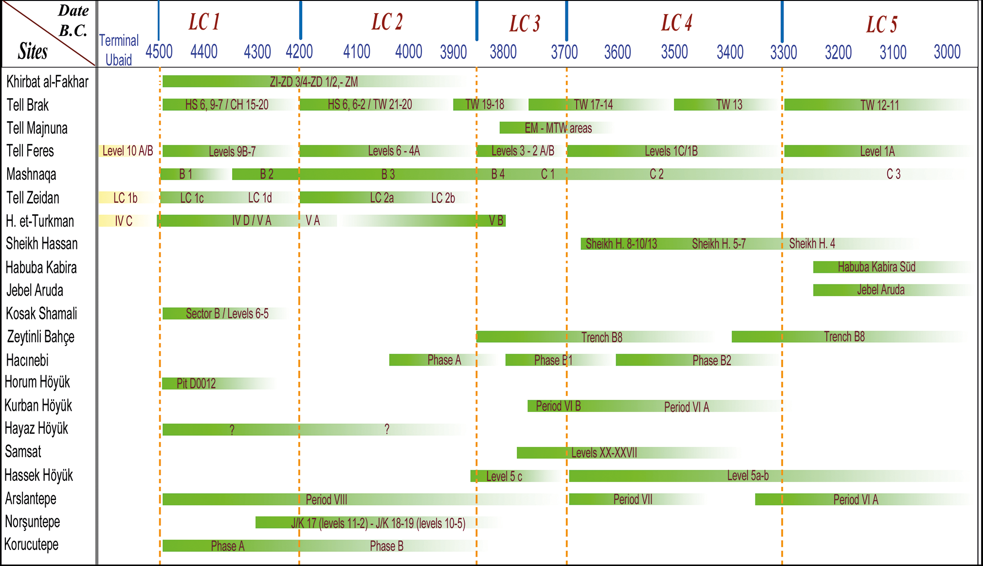
Figure 3 Long description
The table compares various archaeological sites and their corresponding levels and dates in northeast Mesopotamia. It has 21 rows and 11 columns. The columns are labeled with dates B.C. and levels LC 1 to LC 5. The rows are labeled with site names. Each cell contains specific data related to the site and level. Row 1: Khirbat al-Fakhar, ZI-ZD 3/4-ZD 1/2-ZM, HS 6-9/7/CH 15-20, HS 6-6/21-TW 20, TW 19-18, TW 17-14, TW 13, TW 12-11. Row 2: Tell Brak, Levels 9B-7, Levels 6-4A, Levels 3-2/A/B, Levels 1C/1B, Level 1A. Row 3: Tell Majnuna, B 1, B 2, B 3, B 4, C 1, C 2, C 3. Row 4: Tell Feres, LC 1b, LC 1c, LC 1d, LC 2a, LC 2b, IV C, IV D/IV A, VA, VB. Row 5: Mashnaga, IV C, IV D/IV A, VA, VB. Row 6: Sheikh Hassan, Sheikh H 8-10/13, Sheikh H 5-7, Sheikh H 4. Row 7: Habuba Kabira, Habuba Kabira Süd. Row 8: Jebel Aruda, Jebel Aruda. Row 9: Kosak Shamali, Sector B/Levels 6-5. Row 10: Zeytinli Bahçe. Row 11: Hacinebi, Phase A, Phase B1, Phase B2. Row 12: Horum Höyük, PD 0012. Row 13: Kurban Höyük, ?, ?, Period VI B, Period VI A. Row 14: Hayaz Höyük. Row 15: Samsat, Levels XX-XXVII, Level 5 c, Level 5a-b. Row 16: Hassek Höyük, Period VII, Period VII, Period VI A. Row 17: Arslantepe, Period VII, Period VI A. Row 18: Norşuntepe, JK 17 (levels 11-2)-JK 18-19 (levels 10-5), Phase A, Phase B. Row 19: Korucutepe.
In this study, the term ‘Uruk’ is used as a heuristic label for southern Mesopotamian cultural elements, including architectural styles, ceramic assemblages, administrative technologies and iconographic conventions in northern Mesopotamia during LC 4–5 (c. 3500–3000 bc). The term is debated; some prefer the neutral designation LC 4–5 to avoid implying cultural unity or directionality (Potts Reference Potts2004; Rothman Reference Rothman and Rothman2001b; Stein Reference Stein1999a). Similarly, ‘expansion’ and ‘colony’ are retained as descriptive conveniences for well-recognized archaeological phenomena rather than theoretical commitments to core–periphery models (Butterlin Reference Butterlin, Domenici and Marchetti2018; Nissen Reference Nissen and Rothman2001). The documented varied regional responses confirm that any simplistic reading of these terms is inadequate.
The Annales paradigm and archaeological interpretation
The approach adopted here belongs to a broader conversation in archaeological theory about multi-scalar temporality. Bailey’s (Reference Bailey2007) ‘time perspectivism’ argues that different timescales bring different processes into focus, though without formally classifying them into Braudel’s three levels, and Lucas (Reference Lucas2005) has emphasized the palimpsest character of the archaeological record as inherently multi-temporal. The present study retains Braudel’s tripartite framework as an explicit analytical scaffold precisely because the Late Chalcolithic dataset rewards such formal differentiation.
Braudel’s paradigm offers archaeology several advantages. Firstly, this framework facilitates the integration of different forms of evidence across multiple timescales, including environmental data and settlement patterns (longue durée), changes in production organization and demographic trends (conjoncture), as well as specific events such as site destructions (événements). Secondly, it goes beyond archaeological determinism by acknowledging that they do not entirely dictate human behaviour, although structures enable and constrain action. Subsequently, it approaches social transformation as the result of complex interactions operating across time scales, rather than as the result of isolated causes (Bintliff Reference Bintliff and Bintliff1991, 7–8).
Longue durée can be defined as the slowest-moving aspect of history, concerned with the relationships between humans and the environment. Changes at this level are imperceptible within individual lifespans or even generations; they unfold across centuries or even millennia. For Braudel, the longue durée was not merely descriptive geography; it examined how environmental and geographical structures constrained and enabled human action over extended periods (Braudel Reference Braudel and Reynolds1972, 20).
Conjoncture occupies an intermediate temporal position, characterized by ‘slow but perceptible rhythms’ (Braudel Reference Braudel and Reynolds1972, 20). This level addresses histories of groups and social structures across generations or centuries. At this scale, social transformations become visible, though their causes and consequences may only be understood by reference to slower-moving longue durée structures.
Événement represents history’s most rapid rhythm: discrete events and individual actions, characterized as ‘brief, rapid, nervous fluctuations’ (Braudel Reference Braudel and Reynolds1972, 21). Events have meaning only within broader conjunctural and structural contexts, representing critical points at which longer-term processes crystallize into observable action.
Translating Braudel’s temporal framework into concrete archaeological parameters requires explicit methodological grounds. At the longue durée scale, indicators include environmental and geomorphological data, settlement location patterns relative to water sources and agricultural potential, and the distribution of raw material sources, all of which change imperceptibly within human lifespans but exert continuous structuring effects on human behaviour (Bintliff Reference Bintliff and Bintliff1991, 7; Knapp Reference Knapp and Knapp1992, 6). In north Mesopotamia, river systems, rainfall isohyets and highland mineral resources constitute the primary longue durée parameters, visible through the persistent correlation between settlement density and environmental affordances across the Late Chalcolithic sequence.
At the conjoncture scale, indicators include demographic trends visible through changes in settlement size and density, shifts in ceramic production organization from household to workshop contexts, the emergence of administrative technologies such as stamp seals and clay sealings, and the development of mortuary differentiation. These processes unfold across generations and centuries, becoming visible only through diachronic analysis of multiple stratigraphic sequences (Bintliff Reference Bintliff and Bintliff1991, 7–8).
At the événement scale, indicators include discrete episodes of destruction, foundation deposits, mass burials, monumental construction projects and site abandonments—moments when longer-term conjunctural processes crystallize into observable, datable actions. Crucially, événements derive their historical significance only from their conjunctural and structural contexts: a site destruction is meaningless without understanding the medium-term social tensions that produced it (Braudel Reference Braudel and Reynolds1972, 21).
Historians of the Annales school identified mentalités as shared cultural frameworks that shape human action over long periods. A key example is medieval Christianity, which influenced European social life for centuries. In northern Mesopotamia, a similar cultural system is evident through cosmological and administrative symbols. For instance, stamp seal iconography featuring lions, bulls and geometric motifs persisted across regions like Tepe Gawra and Tell Brak, despite geographical distances and time. Moreover, the tripartite architectural tradition from the late Ubaid through LC 2 reveals a long-lasting spatial conception of social and ritual organization. These shared systems formed a Mesopotamian mentalité that structured social interaction and legitimized authority well before contact with southern Uruk (Table 1).
Temporal scales, operating factors and key examples in the Late Chalcolithic of northern Mesopotamia.
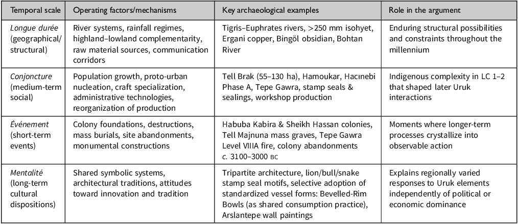
Table 1 Long description
A table with four rows and four columns. The columns are labeled Temporal scale, Operating factors/mechanisms, Key archaeological examples, and Role in the argument. The rows are labeled Longue durée (geographical/structural), Conjoncture (medium-term social), Événement (short-term events), and Mentalité (long-term cultural dispositions). Row 1: Longue durée (geographical/structural), River systems, rainfall regimes, highland-lowland complementarity, raw material sources, communication corridors, Tigris-Euphrates rivers, >250 mm isohyet, Ergani copper, Bingöl obsidian, Bohtan River, Enduring structural possibilities and constraints throughout the millennium. Row 2: Conjoncture (medium-term social), Population growth, proto-urban nucleation, craft specialization, administrative technologies, reorganization of production, Tell Brak (55-130 ha), Hamoukar, Hacinebi Phase A, Tepe Gawra, stamp seals & sealings, workshop production, Indigenous complexity in LC 1-2 that shaped later Uruk interactions. Row 3: Événement (short-term events), Colony foundations, destructions, mass burials, site abandonments, monumental constructions, Habuba Kabira & Sheikh Hassan colonies, Tell Majnuna mass graves, Tepe Gawra Level VIII fire, colony abandonments c. 3100-3000 BC, Moments where longer-term processes crystallize into observable action. Row 4: Mentalité (long-term cultural dispositions), Shared symbolic systems, architectural traditions, attitudes toward innovation and tradition, Tripartite architecture, lion/bull/snake motifs, selective adoption of standardized vessel forms: Bevelled-Rim Bowls (as shared consumption practice), Arslantepe wall paintings, Explains regionally varied responses to Uruk elements independently of political or economic dominance.
Notably, these temporal levels are not distinct categories, but intertwined aspects of a single, unified historical process. A comprehensive historical examination must address all three temporal scales simultaneously, examining how rapid events emerge from, and potentially transform, slower-moving social and geographical structures.
Regional and chronological framework
Longue durée: geographical structures as enduring constraints
Northern Mesopotamia encompasses diverse regions extending from the Zagros piedmont eastward to the upper Euphrates valley westward, and from the Taurus foothills northward to the boundary between rain-fed and irrigated agriculture southward. This study focuses on several sub-regions: the Erbil Plain and the Iraqi Jazira; the upper Tigris basin; the Khabur and Balikh basins; the middle and upper Euphrates valleys; and the Altınova plain. Each region has distinctive environmental characteristics that have profoundly influenced settlement location, subsistence strategies and resource exploitation, not as deterministic forces but as longue durée structures that create enduring possibilities and constraints.
The Tigris and Euphrates basins create an essential geographical niche, providing not only water for agriculture and consumption but also major communication routes linking highland resource zones with lowland agricultural areas. This multifunctional role persisted continuously throughout the Late Chalcolithic, enabling exchange, communication and cultural transmission across millennia. Unlike southern Mesopotamia, where irrigation agriculture was essential, most of north Mesopotamia receives sufficient rainfall (above 250 mm annually) to support rain-fed agriculture. However, precipitation decreases southward toward the 200 mm isohyet (Tamburrino Reference Tamburrino and Mays2010: 29), resulting in distinct agricultural regimes and settlement possibilities. This rain-fed capacity represents a longue durée advantage: northern communities were not dependent on labour-intensive irrigation systems, enabling various forms of social organization and settlement dispersal.
The dual function of these river systems, serving as both agricultural enablers and communication corridors, constituted a longue durée structure throughout the Late Chalcolithic. Evidence for riverine navigation in Mesopotamia dates back to the sixth millennium bc (Broodbank Reference Broodbank2013, 290). An Ubaid-period clay boat model from Mashnaqa demonstrates that river travel was an established practice (McIntosh Reference McIntosh2017, 206), while a fragment of a reed boat from Hacınebi, dated to c. 3800 bc (Schwartz Reference Schwartz2002, 617), suggests continuity into the Late Chalcolithic. These rivers facilitated not merely local movement but also extensive communication networks connecting diverse regions over hundreds of kilometres.
Although archaeological evidence cannot provide a comprehensive map of overland communication routes, two routes documented from later periods appear to have maintained almost unchanged for millennia, suggesting longue durée persistence. One route originated at Sippar in the south, continued along the River Tigris to Nineveh, passed westward to Tell Brak and northward through the Harran Plain, while another followed the River Euphrates in a north–south direction (Bossuyt et al. Reference Bossuyt, Broze and Ginsburg2001, 374).
Each of these routes enhanced the strategic advantage of settlements at the intersections within this network. The distribution of specific materials demonstrates the long-term operation of river-based networks: Sprig Ware was distributed along the Tigris river valley from Tepe Gawra westward to Tell al-Hawa and northward to the Cizre Plain and Başur Höyük during LC 3–5, demonstrating Uruk materials circulating densely along the Euphrates. These are not coincidences but reflect the longue durée structural advantages of riverine routes.
The highlands of eastern Anatolia provided crucial mineral resources: copper ores at Ergani Maden, obsidian sources at Bingöl and Nemrut Dağ, timber, and various stone types. These highland resources exerted a continuous influence throughout the period, creating exchange networks linking lowland groups to highland sources that persisted regardless of political changes or cultural transformations. The permanent complementarity between resource-rich highlands and agriculturally productive lowlands represents another longue durée structure, creating what might be termed ‘structural interdependence’ that no individual community or political entity could transcend.
According to the Santa Fe chronology, the Late Chalcolithic spans approximately 1500 years (c. 4500 to 3000 bc) (Rothman Reference Rothman and Rothman2001b, table 1.1). LC 1 (c. 4500–4200 bc) witnessed the gradual abandonment of Ubaid-style painted pottery in favour of mass-produced plain wares, including ubiquitous Coba bowls, and hand-made mineral-tempered scraped vessels (Garstang Reference Garstang1908). This transition was not uniform across the region: analysis of potting traditions across northern and southern Mesopotamia shows that different sub-regions distanced themselves from the shared Ubaid interaction sphere at different rates and through different mechanisms, with the eastern Khabur bridging connections between Tigris and Euphrates traditions while Iraqi Kurdistan developed distinct highland-oriented assemblages (Abu Jayyab & Gibbon Reference Abu Jayyab and Gibbon2022, 28–9). The slow wheel (tournette) facilitated greater standardization of pottery. In LC 2 (c. 4200–3700 bc) the indigenous development continued with increasing social complexity: the expansion of proto-urban centres such as Tell Brak (55 ha) and Hamoukar; the emergence of administrative technologies, including stamp seals and clay sealings; craft specialization, evidenced by workshops; and intensified long-distance exchange. Pottery assemblages included widely distributed diagnostic types such as hammerhead bowls, casseroles and chaff-faced wares (Stein Reference Stein2012, 140).
LC 3 (c. 3700–3500 bc) marked a transitional phase of indigenous developments that continued alongside the emergence of Uruk materials from southern Mesopotamia. At Tell Brak, bevelled-rim bowls (hereafter BRBs) appeared in level 16, dated c. 3600 bc or earlier (Oates & Oates Reference Oates and Oates1991). Tell Brak expanded to approximately 130 ha (Oates et al. Reference Oates, McMahon, Karsgaard, Quntar and Ur2007, 597), while settlement patterns across sub-regions intensified. LC 4 (c. 3500–3300 bc) coincided with the establishment of the Uruk enclave in the middle Euphrates valley, as evidenced by Tell Sheikh Hassan, Habuba Kabira and Jebel Aruda, which displayed complete southern Mesopotamian cultural assemblages (Algaze Reference Algaze1993; Stein Reference Stein1999a). LC 5 (c. 3300–3000 bc) saw the high density of distribution of Uruk-related materials across north Mesopotamia, from Nineveh and Başur Höyük eastward to numerous Euphrates valley sites, and witnessed complex interaction patterns between indigenous northern societies and southern-derived cultural elements before the abandonment of the Euphrates colony and the general Uruk decline (Algaze et al. Reference Algaze, Hammer and Parker2012; Sağlamtimur & Kalkan Reference Sağlamtimur and Kalkan2015).
Indigenous developments: LC 1–2 as conjoncture
The LC 1–2 (c. 4500–3700 bc) encompass over 700 years of indigenous cultural development, a span equivalent to the entire Uruk phenomenon. Yet these centuries have received considerably less scholarly attention than subsequent Uruk-related phases, reflecting the analytical bias toward external contact over indigenous trajectories. This extended period witnessed significant transformations that we interpret as conjoncture: medium-term social processes unfolding across generations, creating the complex societies that would subsequently interact with southern Mesopotamian polities.
Tell Brak and the emergence of urban complexity
Tell Brak provides exceptional evidence for early urbanization as conjoncture, a medium-term process rather than a sudden event. LC 2 occupation may have covered approximately 55 ha across the central mound (Ur et al. Reference Ur, Karsgaard and Oates2007, 1188), representing demographic nucleation that required generations to develop and social innovations to sustain. The ‘Basalt Threshold Building’ in Level 20 represents monumental architecture, suggesting socio-political complexity (McMahon Reference McMahon, Bonatz and Martin2013, 75; Oates et al. Reference Oates, McMahon, Karsgaard, Quntar and Ur2007, 588), not only as an elite display but also as the materialization of social hierarchies emerging gradually through conjunctive-scale processes.
A western building on Level 20 contained workshops manufacturing ceramics, flint and obsidian tools, shell and obsidian inlays and beads, alongside the processing of staple goods, representing a fundamental conjoncture-scale transformation in production organization: a gradual shift towards more organized, workshop-based production contrasting to purely household-based manufacture. The LC 2 pottery at Tell Brak and Hamoukar reveals that despite shared pottery types, technological traditions diverged: Brak utilized updraft kilns and sophisticated surface treatments, while Hamoukar relied on open firing and pit kilns, reflecting regionally distinct conjoncture-scale trajectories in production organization. Simultaneously, a broader shift toward standardization occurred across LC 2; vessel diversity at Hamoukar halved, from fourteen types to seven by LC 3, as chaff tempering increased and painted decoration disappeared. Such demand-driven reorganization indicates that production shifts operated as a regional conjoncture rather than a site-specific development (Al Quntar & Abu Jayyab Reference Al Quntar, Abu Jayyab, McMahon, Crawford and Postgate2015, 95–106). Such transformation did not occur suddenly but unfolded across generations as communities experimented with labour specialization, established training systems and created social mechanisms to coordinate production. Specifically, standardized hemispherical clay spindle whorls suggest organized textile production (McMahon Reference McMahon, Bonatz and Martin2013, 75–6), indicating not only technical standardization but also a social reorganization of gendered labour, whereby textile production traditionally associated with household contexts was brought under institutional coordination.
Clay sealings, some used multiple times, indicate multi-level control of goods, bureaucratic practices requiring conceptual innovations in record-keeping, social agreements about property and authority and the institutionalization of administrative roles. Seal iconography, including lion–animal combats, snakes and vultures, has parallels at Tepe Gawra, Hamoukar and Hacınebi (McMahon Reference McMahon, Bonatz and Martin2013, 77–8), suggesting shared symbolic systems or mentalité among northern communities. This iconographic similarity across vast distances raises crucial questions about cultural transmission and social networks operating at conjoncture scale: how did communities hundreds of kilometres apart develop similar symbolic worlds? The answer likely involves the longue durée of riverine networks that enable sustained interaction across generations, creating shared cultural horizons.
These conjoncture-scale administrative developments were inextricably linked to longue durée structures. Tell Brak’s riverine position along the Khabur corridor fostered interaction networks facilitating shared symbolic and administrative practices across vast distances. Ceramic network analysis confirms this structural advantage: the eastern Khabur, with Brak at its core, functioned as a mediating boundary zone between the Tigris basin and northwestern traditions. Ultimately, this strategic position within the Khabur headwaters directly enabled the proto-urban nucleation during LC 2 (Abu Jayyab & Gibbon Reference Abu Jayyab and Gibbon2022, 29, 32).
Northeast Mesopotamia: differential trajectories and longue durée constraints
During LC 1-2, archaeological evidence in northeastern Mesopotamia indicates three key conjunctural-scale developments, though with significant regional variation reflecting longue durée geographical positions. First, architectural continuity with the Ubaid tradition persisted through tripartite buildings at major centres. At Tepe Gawra XII–XI, multi-function buildings combined domestic, craft production, ritual and storage activities (Rothman Reference Rothman and Rothman2001c, 371–3; Rothman & Blackman Reference Rothman and Blackman2003, 6). Similar structures appeared at Grai Resh level IIB (c. 4250-3850 bc) with specialized workshop areas, and at Qalinj Agha I–V (Kepinski Reference Kepinski2011, 56; Lupton Reference Lupton1996, 33; Peyronel & Vacca Reference Peyronel and Vacca2015, 98). This architectural conservatism across centuries represents a form of mentalité, reflecting persistent cultural preferences for spatial organization transcending individual building events.
Second, craft specialization emerged, as evidenced by bead workshops at Grai Resh, containing hundreds of calcite, bone, shell, flint and obsidian beads alongside stamp seals (Kepinski Reference Kepinski2011, 56), providing material evidence for the conjunctive-scale process of occupational differentiation. In the upper Tigris basin, Salat Tepe IB revealed pottery workshops with quadrangular storage units (Ökse Reference Ökse2015, 18; Ökse et al. Reference Ökse, Görmüş, Koizumi, Meier and Soyukaya2012, 180), while Başur Höyük produced rectangular structures with storage vessels (Sağlamtimur & Kalkan Reference Sağlamtimur and Kalkan2015, 59).
Third, long-distance exchange intensified dramatically during LC 2, reflecting a conjoncture fundamentally shaped by longue durée geographical structures. Tepe Gawra XII yielded obsidian from Van region, lapis lazuli from Badakshan and gold from Taurus resources (Rothman Reference Rothman2002, 81). The presence of lapis lazuli from Afghanistan, over 2000 km distant, demonstrates exchange networks operating at scales previously unrecognized for this period, suggesting down-the-line exchange mechanisms sustained across generations. Sprig Ware was distributed widely from Tepe Gawra westward to Tell al-Hawa and northward to the Cizre Plain and Başur Höyük (Rothman Reference Rothman and Rothman2001c, 371–3), indicating ceramic traditions moving along river corridors. Tell al-Hawa, dominating the north Jazira plain at approximately 50 ha, contained clay sealings with stamp seal impressions connecting it to broader administrative practices at Qalinj Agha and Norşuntepe (Ball et al. Reference Ball, Tucker and Wilkinson1989, 32; Lupton Reference Lupton1996, 28; Wilkinson & Tucker Reference Wilkinson and Tucker1995), evidencing that bureaucratic implications were not isolated developments but shared conjoncture across the region.
Social differentiation becomes archaeologically visible through mortuary practices and elite architecture, événements that nevertheless reflect longer conjoncture processes of status formation. At Qalinj Agha, infant jar burials contained exotic grave goods including gold beads and obsidian spatulae (Lupton Reference Lupton1996, 32), while elite residences featured wall paintings, female figurines and altars (Peyronel & Vacca Reference Peyronel and Vacca2015, 98). The circular ‘round house’ at Tepe Gawra XI contains domestic artefacts, mace heads and game stones suggesting occupation by elevated-status individuals (Rothman & Blackman Reference Rothman and Blackman2003, 6–9).
The sequence reveals conjoncture in action, showing a gradual evolution from LC 1–2 complexity toward concrete hierarchical systems. The ‘White House’, ‘Round House’ and ‘Central Warehouse’ materialize this evolving organization across generations. Sophisticated bureaucratic tools, including stamp seals and sealings, alongside exotic materials like lapis lazuli, gold and obsidian, demonstrate the socio-economic levels achieved through these medium-term developments. However, this highly developed cultural system ends with a destructive événement: the destruction of level VIIIA by fire (c. 3700–3600 bc). This conflagration has been associated with competition over new exchange opportunities, possibly resulting in internal conflict or ‘resentment’ (Rothman Reference Rothman2002). The événement of destruction crystallizes longer conjoncture processes, including emerging social stratification, intensifying exchange networks and competing political factions, demonstrating how medium-term transformations can culminate in rapid, traumatic historical moments. This sequence underscores the analytical value of temporal plurality: Tepe Gawra’s longue durée position along exchange routes facilitated a conjoncture of accumulating complexity, which eventually triggered the événement of destruction. Integrating all three levels is essential; none alone can adequately explain the centre’s rise or collapse.
The Upper Tigris basin shows a more elementary development than the Iraqi Jazira, a pattern explicable through longue durée geography. Surrounded by mountains (the Taurus, Zagros, Mardin and Karacadağ ranges) creating natural barriers, the Upper Tigris remained relatively isolated, limiting the intensity of interregional interaction compared with more accessible regions such as the Khabur basin or the Iraqi Jazira. At Yenice Yanı, LC sequences produced household debris, decorated conical loom weights evidencing textile production, alongside ceramics combining Ubaid-derived painted types with Coba bowls (Bernbeck & Costello Reference Bernbeck, Costello, Doonan and Tuna2011, 660; Bernbeck et al. Reference Bernbeck, Costello and Ünal2004, 118).
Northwest Mesopotamia and middle Euphrates: contrasting conjonctures
Northwest Mesopotamia witnessed particularly significant developments during LC 2, creating ‘precocious complexity’. In the Khabur basin, Khirbat al-Fakhar (Hamoukar) served as a primary centre for obsidian production and trade, with obsidian accounting for 97% of lithic assemblages sourced from the Van region. This extreme specialization, which is nearly exclusively focused on a single material, represents a conjunctural-scale economic transformation: the community reoriented its entire productive economy around exploiting its strategic position along obsidian distribution networks, a process that required generations to establish trading relationships, develop technical expertise and create social mechanisms for managing concentrated wealth. Extended-family houses contained multiple rooms for various purposes, including obsidian workshops and textile production (al-Quntar et al. Reference al-Quntar and Khalidi2011, 154–6, 162; Khalidi et al. Reference Khalidi, Gratuze and Boucetta2009, 890).
Tell Feres provides well-preserved architectural sequences from the terminal Ubaid through LC 2, revealing conjoncture in action. Level 9 (LC 1) contained a communal structure with a central hall and numerous Coba bowls associated with communal meals, evidencing commensality practices that created and reinforced social bonds. Level 8 produced pottery kilns, suggesting specialized production, while level 6 (early LC 2) displayed a regular spatial distribution, suggesting proto-urban organization or systematic planning. This architectural regularity implies centralized decision-making and coordinated construction, which reflect social capacities that developed gradually across conjoncture timeframes. Obsidian derived from Bingöl A, Nemrut Dağ and Ararat sources (Baldi Reference Baldi2012, 130–31; Vallet & Baldi Reference Vallet, Baldi, Kanjou and Tsuneki2016, 94–7) demonstrate access to multiple highland sources along longue durée exchange corridors.
In the Balikh basin, Tell Zeidan (12.5 ha) provides critical evidence for the transition from the Terminal Ubaid to LC 1: a building with niched and buttressed walls, suggesting a public or temple function, alongside 15 pinched clay sealings indicating administrative activity (Stein Reference Stein2010, 110). The bureaucratic paraphernalia emerging contemporaneously with those at Tell Brak suggests a regional conjuncture in administrative innovation. Evidence for long-distance exchange includes bitumen hafted flint for sickle blades (source 70 km south), obsidian (5% of chipped stone, from Bingöl or Nemrut Dağ) and a stone stamp seal depicting a deer with stylistic affinities to Tepe Gawra, suggesting shared symbols among leaders (Stein Reference Stein2009, 134–5). Hammam et-Turkman VB’s imposing building, dated c. 4230–3940 bc, featured triple recessed niches flanked by storage rooms, with parallels at Tepe Gawra and Uruk, suggesting central economic functions (Meijer Reference Meijer and Van Loon1988, 76; Wright & Rupley Reference Wright, Rupley and Rothman2001, 99). Tell Kosak Shamali provides pottery workshop in LC 1 (levels 6–5, c. 4300 bc), with two well-preserved large kilns suggesting mass production, situated away from domestic areas, indicating specialized involvement (Nishiaki Reference Nishiaki, Kanjou and Tsuneki2016, 76–8), a spatial segregation of production reflecting social differentiation of labour.
The relationship between northern and southern Mesopotamian chronologies is complex, illustrated by Hammam et-Turkman. Level VB’s monumental building, dated around 3200 bc based on ceramics, has a calibrated date of 4090 bc (Akkermans Reference Akkermans1988). Its design resembles typical Uruk temples, although the associated ceramics belong to the local Amuq F tradition rather than the southern Uruk repertoire. Unique to northern Mesopotamia, it may indicate southern architectural influence, while maintaining indigenous ceramic tradition, raising questions about whether it reflects early or later cultural exchange. This underscores the need for refined chronologies to differentiate between large-scale cultural shifts and localized adoptions.
In the Middle Euphrates Valley, Hacınebi (3.3 ha) provides exceptional evidence for indigenous complexity before Uruk contact, which is crucial for demonstrating that sophisticated social organization existed independently of southern influence. Phase A (LC 2, c. 4050–3800 bc) comprises handmade, chaff-tempered Amuq F-related local Anatolian pottery (Stein Reference Stein and Rothman2001, 270). Architectural remains reveal pre-existing social complexity as a conjoncture: storerooms with administrative and metallurgical activities; a monumental stone enclosure wall (Wall 68), standing 3.3 m high with 2 m wide niches, from the first quarter of the fourth millennium bc (Pearce Reference Pearce, Marro and Hauptmann2000, 115); and a massive mudbrick building suggesting a public function (Stein & Mısır Reference Stein and Mısır1994, 152–3). The construction of this 3.3 m high wall represents an événement in the form of a specific construction, materializing longer conjoncture processes of political centralization and labour mobilization capacity.
Mortuary practices reveal social stratification as conjoncture: infant jar burials, one containing a miniature vessel, a copper ring and two silver earrings, which are extremely rare in southeast Anatolia. The deposition of precious metals with infants suggests ascribed rather than achieved status, indicating hereditary inequality developed across generations. Bureaucratic paraphernalia included stamp seals and seal impressions depicting animals and geometric motifs, suggesting record-keeping for goods, taxes, or tribute (Stein Reference Stein and Rothman2001, 273–5).
Long-distance exchanges demonstrating participation in longue durée networks include chlorite (250 km away in Diyarbakır), cowrie shell beads (Mediterranean), obsidian from diverse sources (Nemrut, Bingöl, Göllüdağ, Gutansar) and silver earrings likely from the Altınova Plain. This material diversity reveals Hacınebi’s strategic position, with access to multiple longue durée exchange corridors including highland Anatolia, Mediterranean coast and Mesopotamian linkages. This geographical advantage enabled the conjoncture of wealth accumulation and political complexity. Metallurgical activities appear decentralized: copper artefacts, casting moulds, crucibles, slags and a tuyere indicate on-site processing of copper of Ergani (Stein Reference Stein and Rothman2001, 266–77; Stein et al. Reference Stein, Edens and Edens1998, 167), suggesting metallurgical knowledge was widely distributed rather than tightly controlled.
Altınova and Malatya Plains: metallurgy and highland–lowland complementarity
In the Malatya Plain, Arslantepe VIII (c. 4300–4000 bc, LC 1–2) provides evidence of conjunctural developments in highland contexts. Multiple architectural phases contained domestic structures with kitchens, storage rooms and wall paintings. Phase 3 produced infant jar burials, clay spindle whorls, bone awls, pendants and several seals and sealings, suggesting administrative tools. Plain simple ware constituted nearly the entire assemblage, with characteristic scraping associated with Coba bowls common in northern Mesopotamia reflecting ceramic connections demonstrating participation in widespread northern traditions despite the highland location (Balossi-Restelli Reference Balossi-Restelli, Kühne, Czichon and Kreppner2008, 24; Reference Balossi-Restelli2012, 238–42).
In the neighbouring Altınova Plain, Norşuntepe revealed LC 2 levels featuring a multicellular, tripartite building with red-and-black wall paintings, copper ores and slags, and smelting furnaces, indicating copper production associated with the Ergani deposits, 30 km south, in the first half of the fourth millennium bc (Hauptmann Reference Hauptmann1975, 37–8; Reference Hauptmann1982, 29–31). This represents a crucial conjoncture: communities near copper sources developed specialized metallurgical expertise over generations, creating knowledge and productive capacities, positioning them as significant participants in regional exchange networks, though the nature and intensity of this participation varied according to local social and environmental conditions. The longue durée geographical proximity to Ergani created enduring structural advantages that these communities exploited through medium-term social and technical innovations.
Clay bullae and stamp seals depicting geometric and figural motifs, alongside contemporaries at Tepe Gawra, suggest some degree of administrative activity (Hauptmann Reference Hauptmann1976, 55), evidence that such practices were not confined to lowland ‘urban’ centres but emerged across diverse ecological zones, indicating conjunctive-scale administrative emergence as a regional phenomenon. Ceramics included Wide Flower Pots, chaff-faced wares and Sprig Ware, with a wide distribution from Shelgiyya to Tepe Gawra and the Cizre Plain (Gülçur & Marro Reference Gülçur, Marro and Marro2012, 310–23), demonstrating participation in longue durée riverine distribution networks despite the highland position.
Conjoncture synthesis: indigenous complexity as medium-term process
As summarized in Table 2, 700 years before intensive Uruk contact, northern Mesopotamian communities developed substantial social complexity, with population nucleation, production reorganization and administrative innovation unfolding across all sub-regions to create a regionally differentiated landscape whose established practices shaped subsequent Uruk interactions.
Indigenous developments during LC 1–2: regional synthesis.
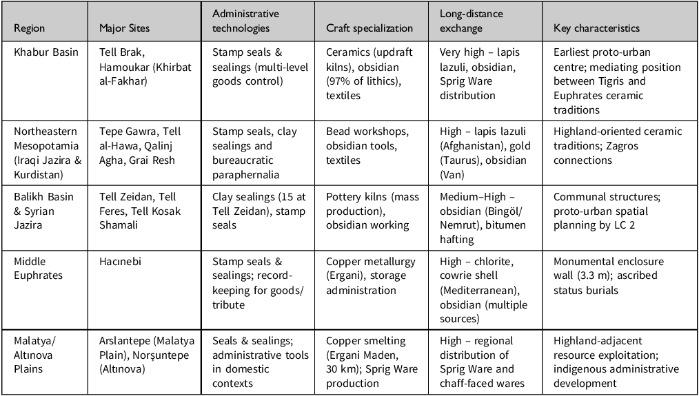
Table 2 Long description
A table comparing regional developments in ancient Mesopotamia during LC 1-2. The table has six rows and six columns. Column headers are Region, Major Sites, Administrative technologies, Craft specialization, Long-distance exchange, and Key characteristics. Row 1: Khabur Basin, Tell Brak, Hamoukar (Khirbat al-Fakhar), Stamp seals & sealings (multi-level goods control), Ceramics (updraft kilns), obsidian (97% of lithics), textiles, Very high – lapis lazuli, obsidian, Sprig Ware distribution, Earliest proto-urban centre; mediating position between Tigris and Euphrates ceramic traditions. Row 2: Northeastern Mesopotamia (Iraqi Jazira & Kurdistan), Tepe Gawra, Tell al-Hawa, Qalinj Agha, Grai Resh, Stamp seals, clay sealings and bureaucratic paraphernalia, Bead workshops, obsidian tools, textiles, High – lapis lazuli (Afghanistan), gold (Taurus (Van)), obsidian, Highland-oriented ceramic traditions; Zagros connections. Row 3: Balikh Basin & Syrian Jazira, Tell Zeidan, Tell Feres, Tell Kosak Shamali, Clay sealings (15 at Tell Zeidan), stamp seals, Pottery kilns (mass production), obsidian working, Medium-High – obsidian (Bingöl/Nemrut), bitumen hafting, Communal structures; proto-urban spatial planning by LC 2. Row 4: Middle Euphrates, Hacinebi, Stamp seals & sealings; record-keeping for goods/tribute, Copper metallurgy (Ergani), storage administration, High – chlorite, cowrie shell (Mediterranean), obsidian (multiple sources), Monumental enclosure wall (3.3 m); ascribed status burials. Row 5: Malatya/Altinova Plains, Arslantepe (Malatya Plain), Norşuntepe (Altinova), Seals & sealings; administrative tools in domestic contexts, Copper smelting (Ergani Maden, 30 km); Sprig Ware production, High – regional distribution of Sprig Ware and chaff-faced wares, Highland-adjacent resource exploitation; indigenous administrative development.
Crucially, these developments were not uniform but varied regionally, as explained by longue durée geographical structures. The Khabur basin and Iraqi Jazira, with accessible riverine corridors and productive agricultural potential, experienced the most intensive urbanization and administrative development. The upper Tigris basin, isolated by mountains, remained more rudimentary, despite participation in exchange networks. The middle Euphrates valley, at the boundary between reliable rain-fed agriculture and marginal conditions, developed differently; sites such as Hacınebi show substantial complexity, yet in contexts emphasizing exchange relationships rather than intensive agricultural production. Highland zones such as the Altınova Plain developed specialized metallurgical expertise, exploiting longue durée proximity to mineral resources.
These regional variations confirm that conjoncture processes operated within longue durée geographical constraints: communities could not transcend their environmental positions but could exploit them, producing a landscape of complex societies whose administrative practices, craft specialization and exchange networks shaped subsequent Uruk interactions by LC 3.
The Uruk Phenomenon as conjoncture: LC 3–5 periods
Southern Mesopotamia: the Uruk conjoncture
In southern Mesopotamia, the Uruk period (c. 4150–3100 bc) saw significant developments culminating in state formation and urbanization, itself a conjunctive-scale process unfolding over a millennium. Uruk/Warka reached 100 ha during Middle Uruk (c. 3800–3350 bc) and 250 ha during Late Uruk (c. 3350–3100 bc), becoming the largest site in the southern lowlands (Pollock Reference Pollock and Rothman2001, 191–2), a demographic concentration far exceeding that of northern centres, yet reflecting similar conjunctural processes of nucleation and social reorganization. Environmental conditions such as declining sea level, increasing aridity from c. 3500 bc and population growth led communities to establish settlements near riversides and arable land, accelerating the construction of complex irrigation canals (Adams Reference Adams1981; Kennett & Kennett Reference Kennett and Kennett2006, 90–91). These environmental pressures represent longue durée processes (e.g. climatic change), triggering conjunctural responses (e.g. irrigation intensification, settlement reorganization).
Administrative technologies emerged: clay tokens, cylinder seals with bullae and the earliest numerical tablets in Eanna IV, ultimately giving rise to pictographic writing (Nissen et al. Reference Nissen, Damerow and Englund1993, 13–14). These innovations represented a conjuncture comparable to northern administrative developments, yet with distinctive southern characteristics (cylinder seals versus stamp seals, numerical notation).
The ‘Uruk expansion’ brought southern cultural elements to northern Mesopotamia during the mid-fourth millennium bc, introducing architecture, ceramic technology and typology, glyptic styles and ideological aspects across the high plains from northern Syria to eastern Anatolia (Frangipane Reference Frangipane and Rothman2001; Schwartz Reference Schwartz and Rothman2001; Stein Reference Stein1999a). However, conceptualizing this as ‘expansion’ risks temporal conflation: the phenomenon spanned approximately 700 years (c. 3700–3000 bc) with multiple phases, regional variations and fluctuating intensities, characteristics of conjoncture rather than événement (Lewis Reference Lewis2025). New data from Girdi Qala and Logardan reinforce this conjoncture reading: southern cultural elements appear as early as late LC 2, predating Euphrates colonies by centuries. This suggests that ‘Uruk’ contact was an extended process of uneven diffusion across multiple temporal waves, rather than a sudden event (Baldi Reference Baldi, Baldi, Iamoni, Peyronel and Sconzo2022). This medium-term character is confirmed by the gradual nature of preceding transitions; just as the Ubaid dissolution proceeded through incremental regionalization (LC 1), the intensification of southern contact during LC 3-5 built upon pre-existing northern structures. Consequently, cultural change in this region operated at a conjoncture rather than an événement scale, shaped by a long-term interaction between southern developments and northern complexity (Abu Jayyab & Gibbon Reference Abu Jayyab and Gibbon2022).
Northeast Mesopotamia: abandonment, continuity and selective adoption
Recent surveys on the Rania Plain fundamentally revise our understanding of regional settlement dynamics. Instead of a size-based hierarchy, LC urbanism in the Zagros foothills comprised networks of functionally differentiated smaller sites, a form of ‘dispersed urbanism’ shaped by localized forces. This model emerged independently of top-down centralization and defies frameworks derived from the large plains of western Mesopotamia (Skuldbøl & Colantoni Reference Skuldbøl, Colantoni, Baldi, Iamoni, Peyronel and Sconzo2022, 3–22). During LC 3–5 in northeast Mesopotamia a prominent événement punctuates the longer trajectory appears: Iraqi Jazira sites, including Tepe Gawra, Helawa, Grai Resh and Qalinj Agha, were abandoned in early LC 3 (Peyronel & Vacca Reference Peyronel and Vacca2015, 95; Rothman Reference Rothman and Rothman2001c, 381). This marks a discrete historical moment, whereby communities decided to abandon established settlements, likely within a generation or two. Yet understanding this événement requires reference to the conjoncture: which medium-term processes created conditions in which abandonment became necessary or attractive? Possible factors include environmental degradation, political instability, or reorientation towards emerging centres, representing explanations that require conjunctive-scale analysis but manifest as rapid événements.
At surviving sites, trajectories continued to be modified. Tepe Gawra VIII (c. 3700–3600 bc) revealed substantial craft areas producing seals, beads and obsidian tools in buildings. A central warehouse with sealings depicting bulls, dogs and snakes suggests a single-authority-controlled goods flow, indicating the involvement of political actors in large-scale networks (Rothman Reference Rothman and Rothman2001c, 390; Rothman & Peasnall Reference Rothman and Peasnall1999, 110)—administrative intensification representing conjoncture continuation from LC 2 practices.
Recent surveys in Iraqi Kurdistan provide new insights into regional dynamics. Tell Helawa (Erbil Plain) shows a continuous LC 1–3 sequence, where local administrative systems developed independently of southern contact. This conjoncture trajectory suggests Uruk elements were incorporated into, rather than replacing, established local frameworks (Peyronel & Vacca Reference Peyronel and Vacca2015; Vacca & Peyronel Reference Vacca, Peyronel, Baldi, Iamoni, Peyronel and Sconzo2022). On the Selevani Plain, 234 LC sites follow wadi systems and perennial springs, reflecting a longue durée adaptation to hydrology that is distinct from that of the Khabur or Jazira plains (Iamoni & Sconzo Reference Iamoni, Sconzo, Baldi, Iamoni, Peyronel and Sconzo2022). Furthermore, LC 1 ceramic network confirms distinct highland potting traditions. The presence of Dalma impressed wares indicates sustained Zagros engagement, reflecting a longue durée positioning at the highland-lowland interface (Abu Jayyab & Gibbon Reference Abu Jayyab and Gibbon2022). Sites including Tall al-Nul, Gird-i Ress, Tepe Yorgan, Tell Begum, Gurga Chiya and Surezha yielded BRBs, bottles and drooping spouts. Nineveh/Kuyunjik re-occupied and sustained growth, while Nineveh 4 (Late Uruk, LC 5) represents completely ‘classic Uruk’ wares with typical materials: pottery, accounting practices, glyptic, iconography (Frangipane Reference Frangipane2009, 33; Rothman Reference Rothman and Rothman2001c, 383), indicating evidence for intensive southern adoption distinguishing Nineveh from sites with selective incorporation.
Recent research refines this landscape by describing the Uruk presence as a ‘mosaic’ of varying settlement patterns. While the northern Tigris remains largely ephemeral, Nineveh is a notable exception. In contrast, new data from Erbil and Sulaymaniyah suggest a more deeply rooted presence than previously recognized, confirmed by petrographic analysis at Gird-i Shamlu and Gurga Chiya. Southern-style vessels, including BRBs, were manufactured using regional clays, indicating that Uruk influence operated through the local adoption of forms rather than importation. Such a pattern aligns with the conjoncture framework, in which communities actively selected and reproduced cultural elements rather than receiving them (Lewis Reference Lewis, Baldi, Iamoni, Peyronel and Sconzo2022, 65–84). This evidence confirms that the selective incorporation of southern materials was part of a highly regionalized process of urbanization, in which local factors and pre-existing prehistoric centres played a strategic role in the emergence of socio-economic complexity (Conati Barbaro et al. Reference Conati Barbaro, Moscone, Iamoni, Bonacossi and Qasim2019; Lewis Reference Lewis2025).
In northern Jazira, settlements increased from 47 (Ubaid) to 68 (late fourth millennium bc), though southern Uruk materials appeared at only seven sites (Wilkinson Reference Wilkinson1990, 56; Wilkinson & Tucker Reference Wilkinson and Tucker1995, 43–4), evidencing conjoncture-scale demographic growth continued independent of Uruk contact, while cultural influence remained geographically restricted.
In the Upper Tigris basin, 61 LC sites were recorded, showing increased settlement density characterized by the Amuq F Chaff-Faced assemblage (Brancato Reference Brancato2017, 55; Marro Reference Marro2010, 37), demonstrating that indigenous ceramic traditions remained dominant despite the Uruk presence elsewhere. Başur Höyük provides exceptional LC 5 evidence, including a possible city wall, public buildings on pebble-stone platforms, drainage infrastructure similar to that at Habuba Kabira, and structures containing typical southern Mesopotamian clay nails and stone eye inlays (Sağlamtimur & Ozan Reference Sağlamtimur and Ozan2013, 514; Sağlamtimur et al. Reference Sağlamtimur, Ozan, Baştürk, Batıhan, Aydoğan and Baş2018). An updated analysis of the Başur Höyük assemblage confirms both the intensity and the selective nature of Uruk adoption. Cylinder seals and cretulae, alongside typical LC 5 ceramics, indicate that administrative practices were integrated into an indigenous institutional framework rather than imported wholesale (Aydoğan et al. Reference Aydoğan, Batıhan, Sağlamtimur, Baldi, Iamoni, Peyronel and Sconzo2022). Pottery is predominantly mineral-tempered, with mould-made chaff-tempered BRBs predominating alongside hammerhead and carinated bowls (Sağlamtimur & Kalkan Reference Sağlamtimur and Kalkan2015, 62), an assemblage suggesting intensive Uruk adoption comparable to that at Nineveh. Başur’s position near the Bohtan River provided longue durée advantages: access to highland resources and riverine communication routes, explaining why this site, rather than others, became a major Uruk centre.
Not all Upper Tigris communities produced Uruk components: Hirbemerdon Tepe and Kenan Tepe detected no genuine Uruk assemblage, but early and late chaff-faced hammerhead bowls and casseroles (Creekmore Reference Creekmore2007, 94–5; Nanucci Reference Nanucci and Laneri2016, 18–19), evidence that communities made choices about cultural adoption reflecting mentalité and local circumstances rather than being passively influenced.
Northwest Mesopotamia: Tell Brak and the earliest contact
Tell Brak provides the earliest evidence of Uruk-related contact, with five BRBs in Level 16, dated c. 3600 bc or earlier (Oates & Oates Reference Oates and Oates1993, 181), an événement marking the first appearance of southern materials in northern contexts. Their find spot in the ‘feasting hall’, with large ovens and faunal remains for large-scale meat consumption, suggests that consumption shifted from household to standard levels (Oates et al. Reference Oates, McMahon, Karsgaard, Quntar and Ur2007, 594–5), representing conjunctive-scale transformation in commensality practices, possibly facilitating Uruk contact.
Tell Brak’s LC 3 (Area TW Levels 17–14) yields chaff-faced ware with wide distribution, while various symbols incised and impressed on vessels, related to pictography before Uruk IV (Oates & Oates Reference Oates and Oates1993, 172–4). These are the evidence for indigenous administrative innovations contemporaneous with, yet independent of, southern developments. Levels 13–12 (LC 4–5) contained local assemblage alongside southern types, including large BRBs with parallels at colony sites and Eanna precinct at Warka (Oates & Oates Reference Oates and Oates1997, 291), cylinder seals, and reserved slip jars with drooping spouts similar to those in Habuba Kabira and Warka (Oates & Oates Reference Oates1993, 171; Reference Oates and Oates1997, 292).
At Tell Majnuna, 450 m north of Tell Brak, three large mass graves were filled episodically in c. 3800–3600 bc, containing a minimum of 143 individuals (McMahon et al. Reference McMahon, Oates and Al-Quntar2007, 155–6; Reference McMahon, Sołtysiak and Weber2011, 205–12). It appears as a traumatic événement whose causes remain debated, but suggests a violent conflict or mass mortality event during the transitional LC 3 period.
Surface collection around Leilan revealed pottery assemblages predominantly local in character, with southern Uruk types recorded at only 5 of 28 sites (Brustolon & Rova Reference Brustolon and Rova2007, 32). Survey around Tell Hamoukar revealed southern Uruk types at 5 sites and local Late Chalcolithic types at 12 sites, while excavated houses yielded no southern Uruk pottery except for a single BRB (Gibson et al. Reference Gibson, Maktash and Franke2002, 53; Ur Reference Ur2002, 65, 67). Overall evidence, including a possible defensive wall, seals, and large ovens, suggests that local state-level polities existed before Uruk contact (Gibson & Maktash Reference Gibson and Maktash2000, 477), demonstrating the indigenous conjoncture towards political complexity continued independently of southern influence.
Middle Euphrates: événements of colonial foundation
The drier marginal Middle Euphrates zone witnessed the establishment of Uruk centres at Tell Sheikh Hassan, Habuba Kabira/Tell Qannas and Jebel Aruda, which are clear événements of colonial foundation. Tell Sheikh Hassan revealed rich southern Mesopotamian materials in 17 sequences dated c. 3680–3200 bc, including pottery, architectural types and record-keeping paraphernalia (Oates Reference Oates1993, 414; Stein Reference Stein1999b, 18; Wright & Rupley Reference Wright, Rupley and Rothman2001, 105). The foundation at c. 3600 bc on virgin soil represents a purposeful decision by specific groups, which is a discrete événement whose causes lie in the intersection of longue durée riverine geography, conjoncture-scale southern organizational capacity and specific historical circumstance.
Habuba Kabira and Jebel Aruda display southern materials, including architectural plans and elements (brick types, cone wall mosaics), pottery production technology and forms and administrative and economic equipment (bullae, tokens, numerical tablets), distinguishing them from local northern contemporaries (Algaze Reference Algaze1993, 25–9; Stein Reference Stein1999b, 15). These sites represent ‘total transplants’ of southern culture, not merely trade posts but complete communities with southern architecture, material culture and, presumably, social organization.
Choosing this specific zone for colonial settlement raises crucial questions that a temporal-plurality framework helps resolve. Over six centuries (c. 3600–3000 bc), southern groups repeatedly selected this marginal region along the middle Euphrates despite its environmental challenges, a pattern that calls for an explanation beyond simple resource-exploitation models. This ‘zone of uncertainty’ experienced drought and limited rainfall, making it unsuitable for intensive agriculture or animal husbandry (Wilkinson et al. Reference Wilkinson, Galiatsatos, Lawrence, Ricci, Dunford and Philip2012, 143, 172). Yet immediately north of this zone, dense settlement patterns extend back to the sixth millennium bc, demonstrating that environmental unsuitability alone cannot explain the colonial preference.
The answer lies in strategic positioning rather than subsistence potential—a longue durée geographical advantage. This location functioned as a critical control point and crossing point (Wilkinson et al. Reference Wilkinson, Galiatsatos, Lawrence, Ricci, Dunford and Philip2012, 173), situated between north Mesopotamia and the highland resources (timber, copper, obsidian), and the wider western exchange networks documented as far as the Amuq plain (Schwartz Reference Schwartz and Rothman2001). For transporting heavy materials like timber, the Euphrates offered superior navigability compared to the Tigris; overland transport was impractical for such loads. This riverine advantage represents a longue durée structural possibility that southern polities exploited through conjoncture-scale organizational developments.
The sparsely inhabited steppe of southern Middle Euphrates is suitable for mobile pastoralists rather than sedentary communities (Porter Reference Porter2012), allowing colonial foundations to proceed without confronting established indigenous polities. Here, the absence of prior conjoncture created opportunities for new événements. Thus, the colonial foundations at Tell Sheikh Hassan (c. 3600 bc), Habuba Kabira and Jebel Aruda (c. 3500 bc) represent strategic exploitation of longue durée geography within a conjoncture of southern expansion. The six-century persistence of this strategy demonstrates the systematic exploitation of structural possibilities, in which événements were shaped by both geography and political-economic developments.
Between the Birecik and Carchemish dams, sites yielded varied Uruk evidence revealing diverse modes of interaction. Zeytinli Bahçe shows marked adoption of a southern pottery assemblage during Middle Uruk, while LC 5 demonstrates reinterpreted LC 3 material culture, creating hybridized assemblages (Frangipane Reference Frangipane, Matthiae, Pinnock, Nigro and Marchetti2010, 188–91), suggesting that communities actively negotiated cultural elements rather than passively accepting them, reflecting mentalité and agency.
Hacınebi B2 (LC 4, 3600–3300 bc) shows continuity in material culture alongside the appearance of Uruk materials, including a nearly complete southern repertoire: pottery types, production techniques, cone wall mosaics, seals, bullae and tokens. The nearly complete Uruk assemblage is interpreted as indicating the establishment of a ‘trading enclave’ at the corner of the northeast mound (Stein Reference Stein1999b, 6, 16; Stein Reference Stein and Rothman2001, 280; Stein & Edens Reference Stein and Edens1999, 167–8), suggesting an événement in which the southern merchant community established a presence within the indigenous settlement, creating a bicultural site with local and southern zones operating simultaneously.
The Hassek Höyük pottery combination—local forms with southern production techniques and the adoption of southern forms in chaff-tempered types—associates with hybridization (Helwing Reference Helwing1999), representing conjunctural-scale cultural mixing rather than événement replacement.
Upper Euphrates: Arslantepe and indigenous political elaboration
Arslantepe VII (LC 3–4) reveals a critical transitional conjoncture preceding the palatial period. Elite residences and Temple D document the gradual institutionalization of hierarchy, where workshop manufacture increased relative to household production (Balossi-Restelli Reference Balossi-Restelli, Baldi, Iamoni, Peyronel and Sconzo2022). Period VI A (c. 3400–3100 bc) witnessed a more concrete system with imposing interconnected buildings (Frangipane Reference Frangipane2016), representing a conjoncture of intensified indigenous centralization, from Period VIII onwards and climaxing during the Uruk period. Metallurgy also reached its peak, with sophisticated production linked to the southern Caucasus and Black Sea (Frangipane Reference Frangipane, Maner, Horowitz and Gilbert2017). This evidence confirms that longue durée highland–lowland complementarity created opportunities for specialized production, exploited through conjoncture innovations.
A large courtyard lies between the substantial building with thick walls (Building 37, or ‘audience building’) and Temple B (Frangipane et al. Reference Frangipane, Manuelli, Vignola, Steadman and McMahon2017, 72). The corridor wall displays a red-and-black wall painting depicting two bull-like animal figures, ‘lozenge’ motifs, and a human figure pulling a cart or plough which are the themes commonly carved on Uruk seals, suggesting hybrid iconography (Frangipane Reference Frangipane2016, 12), representing a mentalité negotiation: an indigenous community selectively adopting southern symbolic elements while maintaining local artistic traditions.
Unlike earlier temples, Temples A and B were less publicly accessible, suggesting that they were reserved for a small number of high-status individuals. A transformation in ritual access represents a conjuncture toward a more exclusive, hierarchical religious organization. South of Temple B, three interconnected buildings served as storage and meal-distribution facilities controlled by prominent agents (Frangipane Reference Frangipane2012, 29–31), demonstrating the materialization of centralized economic control, characteristic of emerging state-level organization.
Symbolic systems and mentalité
Shared symbolic systems appear in seal iconography across LC 1–3. Similar motifs—lions, bulls, snakes, geometric designs—depicted on stamp seals across north Mesopotamia—from Tepe Gawra to Tell Brak, Hacınebi, and Arslantepe—suggest a common symbolic language or shared ideological frameworks (Frangipane Reference Frangipane2012; McMahon Reference McMahon, Bonatz and Martin2013; Stein Reference Stein and Rothman2001). This iconographic similarity across vast distances likely reflects the intersection of longue durée—river systems that provide communication networks—and conjoncture—sustained interaction that creates shared cultural horizons.
The adoption and adaptation of Uruk elements during LC 3–5 reveal mentalité flexibility and agency. At some sites, southern elements were adopted wholesale: Nineveh and Başur Höyük exhibit ‘classic Uruk’ assemblages, suggesting that communities embraced southern material culture in its entirety. At other sites, hybridization occurred, combining local and southern features and demonstrating active negotiation of mentalité. At Zeytinli Bahçe, following abandonment during LC 3, pottery forms associated with Uruk were reinterpreted in LC 5 (Frangipane Reference Frangipane, Matthiae, Pinnock, Nigro and Marchetti2010, 188–91). In turn, these communities, upon returning to the site after a hiatus, selectively adopted southern forms but modified them to local aesthetic and functional preferences. This reflects mentalité as an active cultural process: the creation of new identity from inspired material and the establishment of new authenticity through creative synthesis rather than through extensive adoption or rejection.
These varied responses cannot be explained by longue durée geography alone—communities in similar environmental positions responded differently—nor can conjoncture social structures fully account for the variation. Instead, mentalité proves crucial: communities held different attitudes towards innovation versus tradition, different conceptions of identity regarding their relationship with southern Mesopotamia, and different political calculations about alliances and resistance. The wall painting at Arslantepe depicting a plough-pulling scene exemplifies this negotiation: the theme derives from southern Mesopotamian iconography, yet its execution in the painted medium on an architectural surface represents indigenous Anatolian tradition, neither extensive adoption nor rejection, but creative synthesis.
BRBs represent another aspect of shared mentalité across an exceptionally wide geographical area during LC 3–5. Their presence in significant quantities at numerous sites, together with their highly standardized size and form, suggests their specific functions within Late Chalcolithic communities. However, their precise use remains debated—proposed functions include bread moulds, ration containers, or vessels for specific consumption practices, possibly related to institutionalized commensality or beer production (Nissen Reference Nissen, Adams and Nissen1972). Regardless of their exact function, the widespread adoption of this distinctive southern Mesopotamian vessel form across diverse northern communities, even those showing minimal other Uruk influence, demonstrates mentalité operating independently of political or economic dominance.
Discussion: total history of the Late Chalcolithic
The foregoing analysis reveals multiple temporal rhythms operating simultaneously in north Mesopotamia during the Late Chalcolithic—precisely the phenomenon Braudel’s paradigm addresses. By examining continuity and change through longue durée, conjoncture and événement, a more comprehensive histoire totale emerges than previous interpretations have provided.
At the longue durée scale, geography and the environment exerted continuous influence throughout the millennium. The Tigris–Euphrates river systems were fundamental structures shaping settlement location, subsistence strategies and inter-regional communication. North Mesopotamia’s reliable rainfall (mostly exceeding 250 mm annually) permitted rain-fed agriculture, creating fundamentally different settlement possibilities compared with irrigation-dependent southern Mesopotamia. This enabled dispersed settlement patterns and reduced dependence on centralized water management—a longue durée constraint that created opportunities for forms of social organization not found in the south.
The highland-lowland distinction represents another crucial longue durée aspect. Highland zones provided timber, stone, and metal ores unavailable in the lowlands, creating permanent complementarity. Sites with easy highland access, including Arslantepe in the Malatya Plain, Başur Höyük near the Bohtan tributaries and Norşuntepe near Ergani, could exploit these advantages throughout the period. Conversely, geographical isolation constrained development: the upper Tigris basin, surrounded by mountains, remained relatively low in cultural complexity compared with more accessible regions such as the Iraqi Jazira or the Khabur basin.
Annales historiography often contrasts the lowlands as areas of state order with the mountains as refuges of resistance. In northern Mesopotamia, this pattern is more nuanced. While lowland plains like the Iraqi Jazira and Khabur basin saw intensive urban nucleation and Uruk contact, highland-adjacent communities were not zones of disorder. Arslantepe and Norşuntepe developed sophisticated administrative systems and specialized metallurgy independently of lowland influences. Thus, the Mesopotamian record modifies the classical Annales schema. Highland-adjacent zones functioned as alternative centres of conjoncture complexity, shaped by longue durée access to mineral resources rather than agricultural surplus.
At the conjoncture scale, the regional patterns of indigenous complexity documented in Table 2 reveal ‘slow but perceptible rhythms’ of social transformation across LC 1–3. Population nucleation, production reorganization and administrative innovation unfolded independently across sub-regions, creating complex social structures subsequently shaping Uruk interactions.
The Uruk phenomenon itself represents the most visible conjoncture during LC 3–5, unfolding over approximately 700 years with significant regional variability. As summarized in Table 3, interaction patterns ranged from full colonial transplants in the Middle Euphrates to selective adoption in the upper Tigris and creative synthesis in the upper Euphrates.
Regional variability of Uruk interaction (LC 3–5).
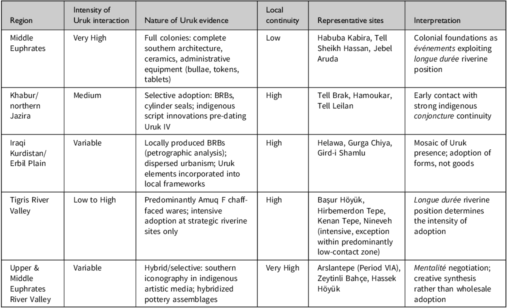
Table 3 Long description
A table comparing the intensity of Uruk interaction across different regions, detailing the nature of evidence, local continuity, representative sites, and interpretations. The table has six rows and five columns. The columns are labeled Region, Intensity of Uruk interaction, Nature of Uruk evidence, Local continuity, Representative sites, and Interpretation. Row 1: Middle Euphrates, Very High, Full colonies: complete southern architecture, ceramics, administrative equipment (bullae, tokens, tablets), Low, Habuba Kabira, Tell Sheikh Hassan, Jebel Aruda, Colonial foundations as evenements exploiting longue duree riverine position. Row 2: Khabur/northern Jazira, Medium, Selective adoption: BRBs, cylinder seals; indigenous script innovations pre-dating Uruk IV, High, Tell Brak, Hamoukar, Tell Leilan, Early contact with strong indigenous conjoncture continuity. Row 3: Iraqi Kurdistan/Erbil Plain, Variable, Locally produced BRBs (petrographic analysis); dispersed urbanism; Uruk elements incorporated into local frameworks, High, Helawa, Gurga Chiya, Gird-i Shamlu, Mosaic of Uruk presence; adoption of forms, not goods. Row 4: Tigris River Valley, Low to High, Predominantly Amuq F chaff-faced wares; intensive adoption at strategic riverine sites only, High, Basur Hoyuk, Hirbemerdon Tepe, Kenan Tepe, Nineveh (intensive, exception within predominantly low-contact zone), Longue duree riverine position determines the intensity of adoption. Row 5: Upper & Middle Euphrates River Valley, Variable, Hybrid/selective: southern iconography in indigenous artistic media; hybridized pottery assemblages, Very High, Arsiantepe (Period VIA), Zeytinli Bahce, Hassek Hoyuk, Mentalite negotiation; creative synthesis rather than wholesale adoption.
Crucially, these three temporal levels did not operate in isolation. The longue durée of riverine networks created the structural preconditions for conjoncture-scale indigenous complexity, which in turn shaped the specific événements of colonial foundation: southern groups selected the Middle Euphrates precisely because its longue durée geographical advantages intersected with a conjoncture of southern organizational capacity and an absence of prior conjoncture in the target zone.
At the événement scale, discrete historical actions punctuate the longer trajectory. The establishment of Uruk colonies represents the clearest événements. Tell Sheikh Hassan, founded c. 3600 bc on virgin soil, constitutes a discrete historical action by specific groups who transported southern Mesopotamian architecture, ceramic technologies and administrative practices to this location. The subsequent establishment of Habuba Kabira and Jebel Aruda, perhaps two centuries later during LC 5, represents additional événements. The abandonment of these colonies at c. 3100–3000 bc constitutes another événement, as do the site destructions, mass graves at Tell Majnuna, and monumental construction projects documented throughout the sequence, representing all moments when longer-term processes crystallized into observable action.
This multi-temporal approach resolves the Uruk debate by demonstrating that Algaze, Stein, and recent scholarship each address different temporal scales, all of which are partially correct but incomplete. It reveals northern communities as active participants rather than passive peripheries, and exposes patterns invisible to single-scale analyses.
Temporal plurality offers a productive framework for studying global cultural contact. The contrast between regions east and west of the Euphrates illustrates this transferable pattern. Western regions, including the Khabur and Balikh valleys, were characterized by intensive Uruk contact and proto-urban centres in rain-fed zones. Conversely, eastern regions—the Upper Tigris and Zagros foothills—maintained stronger Ubaid-derived continuity, experiencing uneven Uruk contact. This asymmetry is explicable through longue durée geography. Western regions occupied accessible riverine corridors, while eastern communities followed trajectories shaped by Zagros resources. This parallels Annales-informed studies of the Maya collapse. Iannone (Reference Iannone2014) demonstrated that longue durée positioning, such as access to water and proximity to trade, determined how Maya communities responded to conjunctural pressures. Ultimately, longue durée geography does not determine outcomes, but structures the range of responses available. In northern Mesopotamia, as in the Maya lowlands, only the interaction of environment and agency across temporal scales explains the archaeological record.
Conclusion
Continuity and change in the Late Chalcolithic of north Mesopotamia operated simultaneously across multiple temporal rhythms. This analysis demonstrates that existing interpretations of the Uruk phenomenon have committed a fundamental temporal fallacy, conflating processes operating at different temporal wavelengths into a single explanatory framework.
Geography and environment exerted continuous influence across the millennium (longue durée). The Tigris–Euphrates river system, rain-fed agricultural potential, and highland–lowland complementarity created enduring structural possibilities. Indigenous social developments during LC 1–3 unfolded across generations (conjoncture). Population growth led to the formation of proto-urban centres at Tell Brak, Hamoukar and Tell al-Hawa. Production organization transformed from a household to a workshop.
The Uruk phenomenon itself represents conjoncture rather than événement. Spanning approximately 700 years with multiple phases and regional variations, Uruk contact constitutes an extended medium-term process. Regional interaction patterns varied dramatically: intensive in the middle Euphrates valley, moderate in the Iraqi Jazira and Khabur basin, minimal in the upper Tigris basin and the Balikh valley.
At the événement level, discrete historical actions punctuate this trajectory. The establishment and abandonment of the Uruk colony, site destructions and monumental construction projects represent moments when longer-term processes crystallized. Crucially, these temporal levels operated simultaneously rather than sequentially.
This multi-temporal approach resolves long-standing debates while revealing patterns invisible to single-scale analyses. The longue durée role of rivers as communication networks, the conjoncture of indigenous northern complexity and the événements of colonial foundation operated together. Recognising that ‘history is a unification of diverse times with different speeds’ (Braudel Reference Braudel and Reynolds1972, 21) transforms interpretation, revealing the past not as a linear sequence but as a plurality of times with different speeds.
Acknowledgements
I would like to express my deepest gratitude to Assoc. Prof. Dr Marie Henriette Gates, whose profound guidance not only shaped my understanding of Fernand Braudel’s historical framework but truly transformed the way I perceive both history and life.

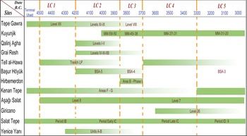
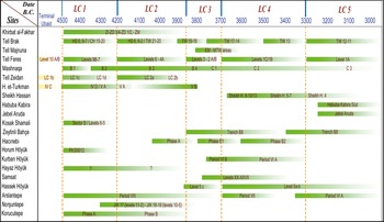
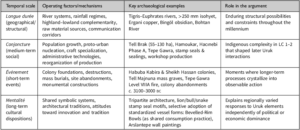
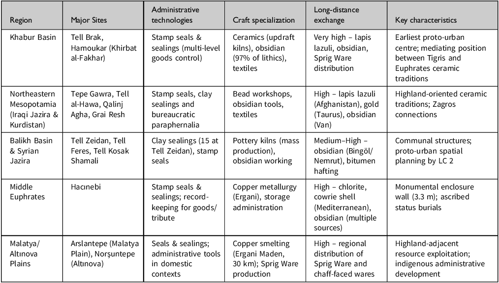
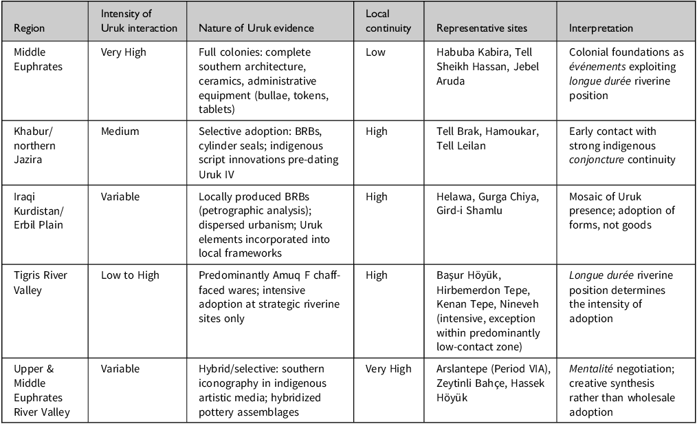

 Open access

